Warm Wisconsin
Easy as 3.141592653589..
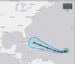
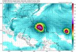
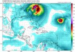
Here is what we know now about Irma
Irma is still very small (25 mile wide Hurricane force winds) but should grow in the next 72 hours
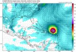
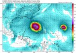
Irma is powerful and organized and will fluctuate in strength for the next 48 hours till it settles on a Cat 3/4.
Edit: Yes this can grow to a Cat 5 in the next week. I was just saying a Cat 3/4 before it turns north.
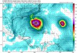
The big question is when will Irma turn north! The models and forecasts have had to keep adjusting west over the last few days. 30-40 miles difference will make a HUGE difference in where this storm will go.
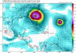
The chances of this storm going "out to sea" are being reduced by the hour, but are NOT at zero.
The chances of this storm going into the gulf are as small as it going to sea.
Almost every model run at the moment has the storm from Florida to Washington DC. However, yesterday they had it going out to sea. (At least the Euro)
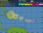
Update:
The storm is growing as expected.
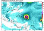
The models are now starting to move to west, but in my opinion to far west. (Models and not NHC forecast) Three days ago the Euro had this going out to Sea, and now it's suggesting a Gulf of Mexico storm.
These models are bi-polar IMHO.
I will still stick with my forecast above - Florida to North Carolina with a slight chance of out to sea.
Gulf of Mexico is a very slight chance.
Still to much uncertainty at this point to know 100%. We might have to wait till Tuesday to know for sure.