WEATHER Official Hurricane Irma Thread- Woo Free

dstraito

TB Fanatic
I have always been fascinated by weather,especially strong hurricanes. One of the metrics I look at is the millibar pressure. I honk Ilma was the lowest with 882 mb. Anytime it gets close to 900 I pay close attention to. I think Irma right now is around 969mb.

Another interesting thing is how the different water temperatures affect storms.

This one for sure deserves watching.
 

Ragnarok

On and On, South of Heaven
Keep all woo off this thread, including but not limited to: talking cats, weather control, MKUltra, HAARP, aliens, conspiracy theories of any and all kinds, and chemtrails.

I mean it. I'll boot anyone off this thread who post that kind of thing.

Gonna be a short thread...

:D
 
Not too many post-hurricane storm paths through the Midwest over the last 164 years (1851-2015), but I was surprised to see that at some point in the past there was a post-hurricane storm path that actually tracked into Hudson Bay. This link (http://www.nhc.noaa.gov/climo/images/1851_2015_allstorms.jpg) saves to a VERY large graphic (65.9 MB) which gives you a fighting chance at following the path of a particular hurricane (no hurricane names, though). Here's the graphic in a much smaller size showing that whatever else hurricanes do they virtually NEVER track in a straight line, so taking the current path of Irma, projecting it in a straight line, then claiming it's definitely going into the Gulf is more an exercise in fantasy than anything remotely related to science.

Damn, that's a lot of spaghetti.
 

Texican

Live Free & Die Free.... God Freedom Country....
Guys,

Have been thinking and praying about Hurricane Irma.

This could turn into a ferocious hurricane that makes Hurricane Harvey pale in comparison.

Prayers to have Hurricane Irma continue to go to the south/southwest or diminish in intensity are needed. Do not have a good feeling about this.

God help us.

Texican....
An American Christina....
Live Free and Die Free....
 

Virtualco

Panic Early - Panic Often
Thanks for that flood insurance update summerthyme. Kinda explains maybe why my homeowners agent hasn't returned my email. I'm here is Cape Coral watching Irma with interest. It's kinda funny I just started kayaking at the first of August, have two with life jackets and stuff. After seeing the people in Houston area I think I am glad I have those. Just in case. But actually if I am smart about the hurricane situation I will be gone from here if a hit looks like it will happen.

My home is 12' above sea level and a direct hit Cat 2 would cause flooding here.

Thanks goodness I got a pickup, even being a short bed Ford Sport Tac it will still be able to haul important stuff out of dodge.

And thank goodness for this thread and board...
 

bw

Fringe Ranger
I just started kayaking at the first of August, have two with life jackets and stuff. After seeing the people in Houston area I think I am glad I have those. Just in case.

While you're prepping, collect a couple lengths of PVC pipe or an equivalent, and some long bungees, so you can make a double-hull out of your two kayaks with a couple feet distance between them. Then you've got something that won't be tippy, can carry two people or you and a good deal of gear in the second boat or strapped on the outrigger pipes. Just in case.
 

TerryK

TB Fanatic
thanks Warm Wisconsin, your first post on this thread would make a great sticky on a general Hurricane prep thread on Main.
It has every hurricane weather resource one can imagine. Add in some great checklists and procedures and we would have a great sticky thread.
People who go to TB2K everyday could have all the weather info they need with one click.
 

Racing22

Crew Chief
Posted by Joe Bastardi, right now projected to go over Bahamas and hit at border of S.C and N.C.

Showing 884 pressure, that's pretty low.
 

Attachments

  • joe2.jpg
    joe2.jpg
    167.3 KB · Views: 438

shane

Has No Life - Lives on TB
Here's a prediction I'll stick my neck out on...

With Harvey floods displacing homeowners and water and fuel shortages, etc. so fresh in everyone's mind,
when it dawns on east coast people that Irma could be playing in a town near them soon, many more are
gonna prep much bigger and much sooner than in the past. Could well be whole lot more than ever before.

That alone has the potential of becoming a disruption crisis unto itself, as it unleashes a contagious panic
prepping stampede with inevitable shortages.

If from past experiences you'd been safe not getting serious about topping off your hurricane supplies till
3-4 days out when track better known, you might want to re-think that and get-r-done now. The pickings
could be really thin and unusually hectic then, with tons more players, if you dare to wait & see this time.

Might turn out that my favorite saying could be especially appropriate next week...

Panic Early, Beat the Rush!

- Shane
 
Last edited:

Lilbitsnana

On TB every waking moment
from S2K
Sun Sep 03, 2017 4:15 pm
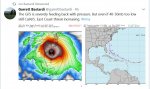
Irma 's size is growing . . .
From 5 PM Advisory:

Hurricane-force winds extend outward up to 35 miles (55 km) from the
center and tropical-storm-force winds extend outward up to 140 miles
(220 km).


At 11 AM, those distances were 25 and 80 miles, respectively.

from NHC

000
WTNT31 KNHC 032050
TCPAT1

BULLETIN
Hurricane Irma Advisory Number 18
NWS National Hurricane Center Miami FL AL112017
500 PM AST Sun Sep 03 2017

...HURRICANE WATCHES ISSUED FOR PORTIONS OF THE LEEWARD ISLANDS...
...NOAA HURRICANE HUNTER AIRCRAFT EN ROUTE TO IRMA...


SUMMARY OF 500 PM AST...2100 UTC...INFORMATION
----------------------------------------------
LOCATION...17.6N 49.8W
ABOUT 790 MI...1275 KM E OF THE LEEWARD ISLANDS
MAXIMUM SUSTAINED WINDS...115 MPH...185 KM/H
PRESENT MOVEMENT...W OR 260 DEGREES AT 14 MPH...22 KM/H
MINIMUM CENTRAL PRESSURE...969 MB...28.62 INCHES


WATCHES AND WARNINGS
--------------------
CHANGES WITH THIS ADVISORY:

The government of Antigua has issued a Hurricane Watch for the
islands of Antigua, Barbuda, Anguilla, Montserrat, St. Kitts, and
Nevis.

The government of the Netherlands has issued a Hurricane Watch for
the islands of Saba, St. Eustatius, and Sint Maarten.

The government of France has issued a Hurricane Watch for St.
Martin and Saint Barthelemy.

SUMMARY OF WATCHES AND WARNINGS IN EFFECT:

A Hurricane Watch is in effect for...
* Antigua, Barbuda, Anguilla, Montserrat, St. Kitts, and Nevis
* Saba, St. Eustatius, and Sint Maarten
* Saint Martin and Saint Barthelemy

Interests in the remainder of the Leeward Islands, the British and
U.S. Virgin Islands, and Puerto Rico should monitor the progress of
Irma. Additional Hurricane and Tropical Storm Watches may be
required for portions of this area on Monday.

For storm information specific to your area, please monitor
products issued by your national meteorological service.


DISCUSSION AND 48-HOUR OUTLOOK
------------------------------
At 500 PM AST (2100 UTC), the center of Hurricane Irma was located
near latitude 17.6 North, longitude 49.8 West. Irma is moving toward
the west near 14 mph (22 km/h). A westward to west-southwestward
motion with some reduction in forward speed is expected through
Monday night. On the forecast track, the center of Irma is
forecast to approach the northern Leeward Islands late Tuesday.

Maximum sustained winds are near 115 mph (185 km/h) with higher
gusts. Irma is a category 3 hurricane on the Saffir-Simpson
Hurricane Wind Scale. Some strengthening is forecast during the
next 48 hours.

Hurricane-force winds extend outward up to 35 miles (55 km) from the
center and tropical-storm-force winds extend outward up to 140 miles
(220 km).

The estimated minimum central pressure is 969 mb (28.62 inches).


HAZARDS AFFECTING LAND
----------------------
WIND: Hurricane conditions are possible within the watch area by
Tuesday night, with tropical storm conditions possible by late
Tuesday.


NEXT ADVISORY
-------------
Next intermediate advisory at 800 PM AST.
Next complete advisory at 1100 PM AST.

$$
Forecaster Brown
 

2x2

Inactive
Not much worried Irma will slap us here but she could cause crop damage affecting can goods price and quantity. Started the annual pre-winter stock up schtick early.
Complete daily menu for minimum of 6 months, with a stash-o-cash backing another 6 months or more if needed. Will finish up this week.
Will be watching store shelves and prices for hints. Bad feelings this time. Spring of 2018 has bothered me for a long time. Will be happy to be wrong.
 

BornFree

Came This Far
Posted by Joe Bastardi, right now projected to go over Bahamas and hit at border of S.C and N.C.

Showing 884 pressure, that's pretty low.

I really have not seen any professional forecaster other than Bastardi calling the point of land fall yet. We shall see if he jumped the gun.
 

Krayola

Veteran Member
Thanks for that flood insurance update summerthyme. Kinda explains maybe why my homeowners agent hasn't returned my email.
I have worked for several major insurance carriers. I remember when Hurricane Andrew and Hurricane Hugo hit (both really bad storms) the insurance carrier I worked for stopped writing any new business for that area during the days leading up to the storm.

Once the meteorologists were able to narrow down a projected path for the storm, the insurance companies refused to write any more new policies for people in that area. So if you lived in the area they would not sell you a policy to insure your home or your car.

If anyone is thinking of writing new insurance, get it now because you may not be able to get it in a few more days if you are in the projected path of this storm. This only pertains to insurance that protects physical property.

If you already have a policy and you just want to update it with new items, etc. I am not sure if this applies to you. (Although, that may be why your agent hasn't replied to your email, Virtualco.)
 

shane

Has No Life - Lives on TB

ontheright

TROPIC LIGHTNING GO 25th
Ryan Maue‏Verified account
@RyanMaue
Follow
More
Last 9 ECMWF forecasts for Hurricane #Irma
It's spread like ensemble spaghetti exemplifying run-to-run uncertainty.

DI1SuJlV4AAqTad.jpg
 

ontheright

TROPIC LIGHTNING GO 25th
Michael Ventrice‏Verified account
@MJVentrice
Follow
More
These are the highest windspeed forecasts I've ever seen in my 10 yrs of Atlantic hurricane forecasting. #Irma is another retiree candidate.

DIl4y_QW0AAzmUH.jpg
 

Virtualco

Panic Early - Panic Often
Thanks Krayola, I will call Tuesday on flood insurance. Could be they are extremely busy also.

Neat tip bw! That could tend to make a stable set-up.
 

psychgirl

Has No Life - Lives on TB
Sooo. We are driving to Athens, GA next Saturday to see my mom, in an Alzheimer's assisted living home.... She's getting bad, the trip has been planned for a month. I live in Indiana.

Will this Irma cause us trouble if it hits NC or near there???
 

Txkstew

Veteran Member
This is my first post on this thread. I just couldn't mentally handle another disaster. God I hope it doesn't come this way, but I wouldn't wish dealing with this on anyone else. My late ex wife used to rebuke these storms in the name of Jesus. It worked most of the time until she passed away. Lets do the same.
 
Not much worried Irma will slap us here but she could cause crop damage affecting can goods price and quantity. Started the annual pre-winter stock up schtick early.
Complete daily menu for minimum of 6 months, with a stash-o-cash backing another 6 months or more if needed. Will finish up this week.
Will be watching store shelves and prices for hints. Bad feelings this time. Spring of 2018 has bothered me for a long time. Will be happy to be wrong.

Complete daily menu, sounds well organized.
Is this something you could share, perhaps in the prep rooms?
 

Beach

Veteran Member
Sooo. We are driving to Athens, GA next Saturday to see my mom, in an Alzheimer's assisted living home.... She's getting bad, the trip has been planned for a month. I live in Indiana.

Will this Irma cause us trouble if it hits NC or near there???

Athens is fairly inland. If it hits in NC Athens will be on the good side of the storm as far as winds go. Rain could be a different story. I wouldn't change my plans if I were you.
 

summerthyme

Administrator
_______________
Thanks Krayola, I will call Tuesday on flood insurance. Could be they are extremely busy also.

Neat tip bw! That could tend to make a stable set-up.

Just remember, flood insurance- if it's available in your area, and it should be given how close to sea level you are- will NOT cover you for Irma, unless it stalls out to sea for 3 weeks or so... there is generally a 30 day waiting period for flood insurance to take effect. I suspect that's because otherwise, people wouldn't bother having it until 3 days before a hurricane hits, and then they'd cancel just as soon as possible- until the next one shows up! Human nature... but DUMB human nature.

Summerthyme
 

Lilbitsnana

On TB every waking moment
So...

Half of the continental US is at risk...

The EURO ensemble had added the Gulf (as far over to western MS) back into the forecast late last night or early this morning; I saw it mentioned around 5 AM.

At that time, the GFS had not, don't know if they have now or not.
 

Lilbitsnana

On TB every waking moment
The EURO ensemble had added the Gulf (as far over to western MS) back into the forecast late last night or early this morning; I saw it mentioned around 5 AM.

At that time, the GFS had not, don't know if they have now or not.


Just looked and yes, the GFS has added it back into the mix.


http://www.weathernerds.org/tc_guidance/images/AL11_2017090300_ECENS.png?8695221


http://www.weathernerds.org/tc_guidance/images/AL11_2017090312_GEFS.png?86041613


ETA: still LOTS of time for things to change
 

ontheright

TROPIC LIGHTNING GO 25th
Track Hurricane Irma‏ @Track_Irma 3m3 minutes ago
More
Official #Irma 8PM Update: Maintaining 115 mph winds. Pressure is down to 959 mb due to recon data. Still moving W 14 mph #hurricane
 

Lilbitsnana

On TB every waking moment
Quote Originally Posted by Lilbitsnana View Post
The EURO ensemble had added the Gulf (as far over to western MS) back into the forecast late last night or early this morning; I saw it mentioned around 5 AM.

At that time, the GFS had not, don't know if they have now or not.

Lilbitsnana said:
Just looked and yes, the GFS has added it back into the mix.


http://www.weathernerds.org/tc_guida...NS.png?8695221


http://www.weathernerds.org/tc_guida...S.png?86041613


ETA: still LOTS of time for things to change


Anything from EUR yet ? Been looking but have seen nada

the top link was the EURO ensemble, the bottom link was GFS.


you can see them side by side at this link:

http://www.weathernerds.org/tc_guidance/storm.html?tcid=AL11

http://www.weathernerds.org/tc_guidance/storm.html?tcid=AL11

ETA: at link above, there are several tabs that can be clicked to see various data and maps.
 
Last edited:

Meemur

Voice on the Prairie / FJB!
Will this Irma cause us trouble if it hits NC or near there???

It's too soon to tell, Psychgirl. Suggestion: proceed as if you are still going on the trip, pack and so on, but don't make a firm decision until Friday when the models will be more accurate. You might be able to go or you might decide that now is not the best time.

So sorry to hear about your mom! That must be rough!
 

Vegas321

Live free and survive
Here is a couple of maps from the GFS 18Z of hour 162 and 204. The models have been pushing the storm sightly south and further west then previous runs. It's looking like the Northern Antilles will get hit with PR getting some piece of Irma. It's getting clearer that the Bahamas chain could get nailed with a strengthening Irma. From that point, it's way beyond certain from the Keys to NC/VA or, OTS. I suspect the NE will most likely not get the fury of Irma. But even that is way beyond ATM.
 

Attachments

  • gfs_mslp_wind_watl_28.jpg
    gfs_mslp_wind_watl_28.jpg
    102.7 KB · Views: 238
  • gfs_mslp_wind_watl_35.jpg
    gfs_mslp_wind_watl_35.jpg
    103.2 KB · Views: 238

shane

Has No Life - Lives on TB
Joe Bastardi‏Verified account @BigJoeBastardi 3h3 hours ago

I will be on @jessebwatters tonight at 8 pm, most likely in the B block which I think is 8:15
 
Top