WEATHER Official Hurricane Irma Thread- Woo Free

bw

Fringe Ranger
Neat tip bw! That could tend to make a stable set-up.

I've righted a kayak when it flipped, but you don't want to be doing that in nasty water. I've righted in a harbor that had a creosote contamination, and the crap coming out of my sinuses for the next week made a real strong impression on me. I've made doubles out of canoes (not kayaks) when I was camping as a kid, and it's a trip!

Get the parts and try it out in advance. You don't have to get in the water, just hook it all up and be confident that you have a workable rig. It might save your butt.

You're gonna need a strong J-stroke or bevel stroke to make that work. If you're good in a canoe, this is a snap.
 

CGTech

Has No Life - Lives on TB
Here's a question i can't find an answer to... the lowest MB on record is 870mb with Tip..... how low is it theoretically possible for the MB on a hurricane to go? And how low can we measure?
 

Vegas321

Live free and survive
Just for giggles... Here is the HMON 18Z Model at hour 126. Yes you are seeing a pressure of 857mb. (that would be a World record BTW,) and Max winds of 157.1 kt. (180 MPH w/200 mph wind gusts.) Oh the doom!!! :D
 

Attachments

  • hmon_mslp_wind_11L_43.png.273767c79329228bf11744ab789408cb.jpg
    hmon_mslp_wind_11L_43.png.273767c79329228bf11744ab789408cb.jpg
    147.6 KB · Views: 418

Wise Owl

Deceased
That's too much doom for a Sunday night when Lil Fat boy is playing with his toys across the pacific.......

Yikes!

And you realize if that thing got that big and hit the east coast and went north, you would also get smacked. Not just NH and Maine, etc.
 

TorahTips

Membership Revoked
Remember, a lot of times the islands rip a hurricane to shreds. If it continues southward, there is a chance it will hit Cuba, Jamaica, Hispaniola, or even just the lesser islands. They may cause serious disorganization.
 

Wise Owl

Deceased
In the meantime, Harvey is here! Heavy rain for the past hour now and looks like according to radar it will still be around for the next while. I have two dogs that are needing to potty very soon and that will mean towels to dry them and ME! Yeesh....... I know it rained harder in Texas but, you would have thought it lost some of that on the way up here to Maine!
 

Krayola

Veteran Member
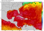
Just remember, flood insurance- if it's available in your area, and it should be given how close to sea level you are- will NOT cover you for Irma, unless it stalls out to sea for 3 weeks or so... there is generally a 30 day waiting period for flood insurance to take effect.
Summerthyme
^^ The above is correct. If you do not have a flood policy now, you can't get coverage in time for Irma. Also, note that homeowner policies do not cover flood. Although they will cover wind damage from hurricanes.

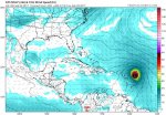
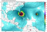
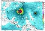
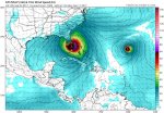
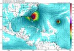
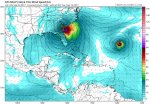
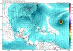
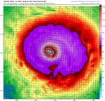
Here's a prediction I'll stick my neck out on...

With Harvey floods displacing homeowners and water and fuel shortages, etc. so fresh in everyone's mind,
when it dawns on east coast people that Irma could be playing in a town near them soon, many more are
gonna prep much bigger and much sooner than in the past. Could well be whole lot more than ever before.

That alone has the potential of becoming a disruption crisis unto itself, as it unleashes a contagious panic
prepping stampede with inevitable shortages.
- Shane
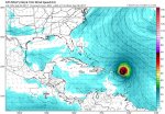
^^ I wonder if that is what happened with hurricane Rita in Texas.

As everyone knows, Katrina was a huge disaster that played out on live TV. I think Katrina put the fear of God into everyone so when Rita came along a few weeks later, everybody decided to haul butt out of there and hit the roads causing huge massive grid lock.

Maybe the gridlock would have happened anyway but I do wonder if the fear of what had just happened in New Orleans was a huge factor. Of course, I could be wrong. I wasn't there.

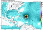
Also, wanted to note that I agree with Shane's assessment of Joe Bastardi. I haven't been following Joe's forecasts as much since he left Accuweather. However, I noticed some years ago that he was forecasting hurricane trajectories (sorry can't remember exact storms but it was some of the big ones we've had over the last decade or so) and his forecasts would come out several days before other people were able to narrow down the path. And sure enough, he usually nailed where it was gonna hit. He amazed me several times. He was accurate and he had the info on where it would hit way before everyone else did.

So I would definitely pay attention to what he is saying, especially if I lived in a hurricane-prone area.
 

Vegas321

Live free and survive
That's too much doom for a Sunday night when Lil Fat boy is playing with his toys across the pacific.......

Yikes!

And you realize if that thing got that big and hit the east coast and went north, you would also get smacked. Not just NH and Maine, etc.

Personally, i'm not worried about the North East ATM. One thing is for curtain, someone is going to get slammed. Even before the EC becomes a threat.

With the Hurricane Hunters going into Irma. Last i've seen, surface winds were at 99kt, 115 MPH CAT 3. They should be able to get that data into the 0Z run and beyond. Like to see how the dynamics of the Models handle it.
 

Txkstew

Veteran Member
In the meantime, Harvey is here! Heavy rain for the past hour now and looks like according to radar it will still be around for the next while. I have two dogs that are needing to potty very soon and that will mean towels to dry them and ME! Yeesh....... I know it rained harder in Texas but, you would have thought it lost some of that on the way up here to Maine!

Try to get two full size dogs to pee in 10 inches of standing water while it rains. They will eventually. I know.
 

shane

Has No Life - Lives on TB
As everyone knows, Katrina was a huge disaster that played out on live TV. I think Katrina put the fear of God into everyone so when Rita came along a few weeks later, everybody decided to haul butt out of there and hit the roads causing huge massive grid lock.

Maybe the gridlock would have happened anyway but I do wonder if the fear of what had just happened in New Orleans was a huge factor. Of course, I could be wrong. I wasn't there.

You got it right, fear of Rita causing a Katrina in Houston had literally millions hitting roads. Not all got stuck in grid lock...

We had blue skies 120 miles away in Gonzales throughout Rita event but exodus from Houston cleaned us out of all fuel,
food and clogged our roads to impassable, here and all over most every town north and west of Houston. Memorable...

- Shane
 

Txkstew

Veteran Member
[QUOTE I wonder if that is what happened with hurricane Rita in Texas.

As everyone knows, Katrina was a huge disaster that played out on live TV. I think Katrina put the fear of God into everyone so when Rita came along a few weeks later, everybody decided to haul butt out of there and hit the roads causing huge massive grid lock.

Maybe the gridlock would have happened anyway but I do wonder if the fear of what had just happened in New Orleans was a huge factor. Of course, I could be wrong. I wasn't there. [/QUOTE]

I was there for Rita. Yes, watching the Katrina aftermath, made me into the Prepper that I am today. My first prep items are labeled in Oct 2005. One month later, I was evacuating with those preps. I haven't let off since.
 

Wise Owl

Deceased
Try to get two full size dogs to pee in 10 inches of standing water while it rains. They will eventually. I know.

Would NOT happen with our two. One is a 100lb malamute and the other a 70lb labradoodle. But, both a squatters......females. No way Ashly the mal would sit in water to pee. Probably Sophie either. That would mean a cold wee wee..........eeeeeeeeewwwwwwww mom, really? You want me to do what???????????????? No way. Ain't happening. I would end up like Old as Dirt and bleaching the kitchen floor!
 

Suzieq

Veteran Member
Just for giggles... Here is the HMON 18Z Model at hour 126. Yes you are seeing a pressure of 857mb. (that would be a World record BTW,) and Max winds of 157.1 kt. (180 MPH w/200 mph wind gusts.) Oh the doom!!! :D
attachment.php


Wow! That's one scary hurricane.
 

packyderms_wife

Neither here nor there.
Keep all woo off this thread, including but not limited to: talking cats, weather control, MKUltra, HAARP, aliens, conspiracy theories of any and all kinds, and chemtrails.

I mean it. I'll boot anyone off this thread who post that kind of thing.

Ahem.... could you open the other thread back up and put it in the Alt News forum, pretty please. :whistle::whistle::whistle: The cat has an, ahem, proclamation to make.
 

Vegas321

Live free and survive
Here is a current Sea Surface Temps in the Western Atlantic. You got a lot of jet fuel around the Bahama's and very warm Gulf Stream up to Hatteras. Irma is about to enter warmer waters just east of the Northern Antilles in the next 12/24 hours. I think Irma is currently in 27/28*C waters.
 

Attachments

  • cdas-sflux_sst_watl_1.jpg
    cdas-sflux_sst_watl_1.jpg
    71.1 KB · Views: 306

Lilbitsnana

On TB every waking moment
attachment.php


Wow! That's one scary hurricane.


it's a forecast image, it is what the models "THINK" it will be like and where it thinks it will be, it is not what it really is at the moment and current location is not even close to the location that image shows.

BULLETIN
Hurricane Irma Advisory Number 19
NWS National Hurricane Center Miami FL AL112017
1100 PM AST Sun Sep 03 2017

...MAJOR HURRICANE IRMA EXPECTED TO BE NEAR THE NORTHERN LEEWARD
ISLANDS TUESDAY NIGHT...


SUMMARY OF 1100 PM AST...0300 UTC...INFORMATION
-----------------------------------------------
LOCATION...17.2N 51.0W
ABOUT 710 MI...1145 KM E OF THE LEEWARD ISLANDS
MAXIMUM SUSTAINED WINDS...115 MPH...185 KM/H
PRESENT MOVEMENT...WSW OR 255 DEGREES AT 14 MPH...22 KM/H
MINIMUM CENTRAL PRESSURE...961 MB...28.38 INCHES
 
Last edited:

fairbanksb

Freedom Isn't Free
I would just ask to pray to which ever god you choose to this storm turn out sea. The vast majority of my extended family live along the N.E. coast of FL. There not much of an escape from a penninsula as long as FL is.
 

vestige

Deceased
I would just ask to pray to which ever god you choose to this storm turn out sea. The vast majority of my extended family live along the N.E. coast of FL. There not much of an escape from a penninsula as long as FL is.

Keep an eye on its path and get the hell out early if necessary.

^^^Sane option^^^
 

Vegas321

Live free and survive
GFS 0Z at hour 60 and 78. PR getting raked.
 

Attachments

  • gfs_mslp_wind_watl_11.jpg
    gfs_mslp_wind_watl_11.jpg
    100.6 KB · Views: 237
  • gfs_mslp_wind_watl_14.jpg
    gfs_mslp_wind_watl_14.jpg
    100.9 KB · Views: 232

Vegas321

Live free and survive
GFS 0Z at hour 96 and 114
 

Attachments

  • gfs_mslp_wind_watl_17.jpg
    gfs_mslp_wind_watl_17.jpg
    103.8 KB · Views: 226
  • gfs_mslp_wind_watl_20.jpg
    gfs_mslp_wind_watl_20.jpg
    104.9 KB · Views: 225

Vegas321

Live free and survive
GFS 0Z at hour 132. Looks REAL close to a landfall on CUBA
 

Attachments

  • gfs_mslp_wind_watl_23.jpg
    gfs_mslp_wind_watl_23.jpg
    103.5 KB · Views: 214

Vegas321

Live free and survive
GFS 0Z at hour 138. Looks like the southern eyewall hitting Cuba. The Eye may be on 5-10 miles off the coast.
 

Attachments

  • gfs_mslp_wind_watl_24.jpg
    gfs_mslp_wind_watl_24.jpg
    105.4 KB · Views: 213

Vegas321

Live free and survive
GFS 0Z at hour 150 and 156. Makes landfall JUST on the coast of Cuba then at 156 turns north.
 

Attachments

  • gfs_mslp_wind_watl_26.jpg
    gfs_mslp_wind_watl_26.jpg
    103.6 KB · Views: 211
  • gfs_mslp_wind_watl_27.jpg
    gfs_mslp_wind_watl_27.jpg
    103.1 KB · Views: 211

Vegas321

Live free and survive
GFS 0Z at hour 168 and 174. The Keys and South FLA get annihilated with a CAT 5
 

Attachments

  • gfs_mslp_wind_watl_29.jpg
    gfs_mslp_wind_watl_29.jpg
    104.7 KB · Views: 196
  • gfs_mslp_wind_watl_30.jpg
    gfs_mslp_wind_watl_30.jpg
    103.3 KB · Views: 194

Vegas321

Live free and survive
GFS 0Z at hour 180 and 186. The whole east coast up to Palm Beach will have 150+ winds lowering to a CAT 4 135 mph winds around Orlando to Daytona Beach.
 

Attachments

  • gfs_mslp_wind_watl_32.jpg
    gfs_mslp_wind_watl_32.jpg
    106.1 KB · Views: 191
  • gfs_mslp_wind_watl_31.jpg
    gfs_mslp_wind_watl_31.jpg
    103.7 KB · Views: 187

Vegas321

Live free and survive
GFS 0Z at hour 192 still a CAT4/3 winds on the east 125+MPH
 

Attachments

  • gfs_mslp_wind_watl_33.jpg
    gfs_mslp_wind_watl_33.jpg
    106.4 KB · Views: 189

Vegas321

Live free and survive
GFS 0Z at hour 198. Just north of Jacksonville/GA line Strong CAT 3 with 115+ winds.
 

Attachments

  • gfs_mslp_wind_watl_34.jpg
    gfs_mslp_wind_watl_34.jpg
    104 KB · Views: 186

Vegas321

Live free and survive
GFS 0Z at hour 204 and 210. Heading towards Atlanta too Eastern TN as a Cat 2/1.

Hows that for Doom boys and girls??? :dvl1:
 

Attachments

  • gfs_mslp_wind_watl_35.jpg
    gfs_mslp_wind_watl_35.jpg
    103.3 KB · Views: 182
  • gfs_mslp_wind_watl_36.jpg
    gfs_mslp_wind_watl_36.jpg
    105 KB · Views: 183
Top