WEATHER Official Hurricane Irma Thread- Woo Free

Warm Wisconsin

Easy as 3.141592653589..
This thread is for discussing Hurricane Irma

I will post some links to do your own investigation

Please PM me links you want added to this list. I'm sure I will add more as I think of them too

Wxman57 has some great links on his website:
http://wxman57.com/hurricane.html

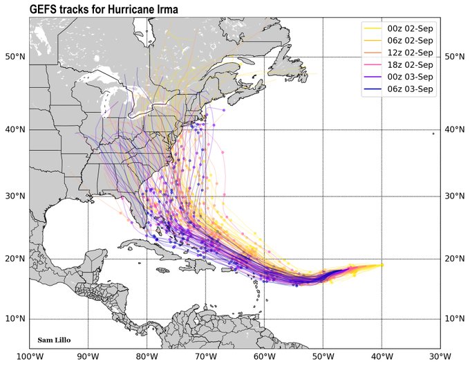
For spaghetti plots, this is a pretty good link:
https://www.sfwmd.gov/weather-radar/hurricane-model-plots

a couple more good ones for general information
https://stormpulse.com/
http://hurricanetrack.com/

Good overall info page

http://spaghettimodels.com

Here is the model verification page, for those interested.

http://www.wpc.ncep.noaa.gov/html/model2.shtml

Latest water vapor and IR loops

http://www.esl.lsu.edu/imagery/atmosphere/?region=tropics&channel=ir

This link you can check out the different ensembles for yourself

https://www.tropicaltidbits.com/analysis/models/

Official NHC main Atlantic page

http://www.nhc.noaa.gov

If you want to see the hundreds of different information layers that go into models -start clicking around this website

https://www.fnmoc.navy.mil/wxmap_cgi/index.html?tab=tropical#tropical

Bearpaws link which has a lot of info.(has the latest advisories on top too)

http://www.bearpawsweather.com/tropical/index.html

Another great site to see satellite loops and other maps

http://www.intellicast.com/Storm/Hurricane/AtlanticSatellite.aspx?animate=true


Links are great but BW's actions below are a great suggestion

If you're personally at risk from Irma, the perfect way for you to spend Sunday is doing what many in Houston now desperately wished they had done.

Take your digital camera, go room to room in your house, open every cabinet, and take pictures of everything you own. Get all the furniture and rugs, all the knickknacks. Get close enough to record the make and model of electronics. Spread out your iThis and iThat and take a picture. Do it in the garage and any outbuildings. Get inside and outside shots of the house in general.

Don't do this with your iThingy unless you have the ability to move masses of pictures off it easily.

Then take all the shots, zip them up, and save them. That means send the zip file to family members across country, or to friends, or upload to the cloud. There are services that will send large files, if your zip file is too big for your email.

If you get hit by a storm, you won't have to struggle to remember all the stuff you have, as you meet with the insurance adjuster.
 
Last edited:

Dennis Olson

Chief Curmudgeon
_______________
Keep all woo off this thread, including but not limited to: talking cats, weather control, MKUltra, HAARP, aliens, conspiracy theories of any and all kinds, and chemtrails.

I mean it. I'll boot anyone off this thread who post that kind of thing.
 

colonel holman

Veteran Member
Keep all woo off this thread, including but not limited to: talking cats, weather control, MKUltra, HAARP, aliens, conspiracy theories of any and all kinds, and chemtrails.

I mean it. I'll boot anyone off this thread who post that kind of thing.

Thank God, and DO

Can you just imagine the epic disaster of this one veering into Gulf and inundate Texas coast again?
 

Dennis Olson

Chief Curmudgeon
_______________
The problem is that the Irma thread was started way too soon. With no hard news to report, speculation and related woo was all there was to talk about. Realistically, the Irma thread should have been started right about, well, now.
 

Bolt

FJB
Thank you for starting a thread for Irma and especially for the links. Irma is definitely going to be one to watch. Wherever she ends up, it's not going to be good. The current WSW trend is a bit nerve rattling, but it has a long way to go with many, many variables.

From NWS, The 5:00AM discussion:

Hurricane Irma Discussion Number 16
NWS National Hurricane Center Miami FL AL112017
500 AM AST Sun Sep 03 2017

Irma's convective pattern has improved slightly overnight. Very
cold cloud tops completely encircle the eye, which has warmed and
become a bit clearer in infrared satellite images. The initial
intensity is raised to 100 kt based on a blend of the latest
subjective and objective Dvorak estimates.

Irma has been losing latitude since yesterday due to strong high
pressure to its north, and the initial motion is now west-
southwestward
, or 255/13 kt. The hurricane is likely to continue
moving on this trajectory for the next 36 hours, after which time it
should gradually turn toward the west and then west-northwest on
days 3-5 when it reaches the western extent of the ridge. The new
NHC track forecast is very similar to the previous one during the
first 48 hours, showing Irma bottoming out around 16.5N. However,
the track guidance has shifted westward after 48 hours, delaying a
turn toward the west-northwest, and this required a corresponding
westward shift in the official forecast toward the multi-model
consensus at the end of the forecast period. It should be noted
that the official forecast still lies to the east of some of the
better-performing models, such as the ECMWF, HWRF, and HCCA, so
additional adjustment are possible in subsequent advisories.
 

colonel holman

Veteran Member
It has had far more time and distance to establish a huge momentum of strengthening before it makes any landfall. Conditions that will determine its track are still out in the pacific, taking their time tomget to Atlantic, thus allowing northern atlantic pressures to mess with the storm track
 

Hfcomms

EN66iq
I'll post this one again.

Forecast track of best performing models.
5-Days out, average error about 65 miles.


0_ms3.png


This is a consensus among current models blending their results and discounting the outliers.
 

Firebird

Has No Life - Lives on TB
I have a motorcycle trip planned for next weekend to the Smoky Mountains from Florida, this storm bears a close watch.
 

Terrwyn

Veteran Member
They keep showing it turning to the North on the models. But looking at those charts, it looks like Irma will go directly into the gulf.
 

mzkitty

I give up.
Hurricane Irma's forecast eyes Bahamas — it's still uncertain but be prepared, officials say

September 3, 2017

Hurricane Irma regained its status as a major Category 3 storm early Sunday as it continued a westward march toward the eastern islands of the Caribbean.

Forecasters said the storm, with top winds of 115 miles an hour, was about 945 miles east of the islands of Barbuda and Antigua, and more than 2,100 miles from South Florida, as of 5 a.m. Sunday.

The storm was moving west-southwest at 15 miles an hour. Some additional strengthening is forecast through Monday night.

There are no coastal watches or warnings in effect.

The strength of Hurricane Irma has fluctuated through the weekend, carrying winds of 130 miles an hour on Friday before subsiding to around 110 mph Saturday morning.

Irma was still days away from the eastern perimeter of the Caribbean, and its potential impact there is uncertain.

Equally uncertain is whether Irma will have an impact on Florida or the U.S. East Coast, but forecaster Dave Roberts at the National Hurricane Center said the storm should be monitored closely.

The latest forecast cone puts the eye of the storm near the southeastern Bahamas at 2 a.m. Friday.

But hurricane forecaster Dan Brown cautioned, “Don’t infer too much from where the end of the cone is pointed.

Relatively small scale changes in the storm’s direction and behavior when far out to sea can mean big differences in the storm’s future track, he said.

“There are limits to predictability,” Brown said.

Still, “a storm headed in the general direction of Florida and the Southeast U.S. is something people should pay attention to,” said Brown. “It is not time to panic. But it is the peak of the hurricane season and a holiday weekend is a good time to stock up on hurricane supplies.”

Hurricane-force winds extend outward up to 25 miles from Irma’s center, and tropical-storm-force winds extend outward up to 80 miles, forecasters said.

The new forecast track is similar to the previous one during the first 48 hours that indicated a turn to the west-northwest. That turn may now be delaying, meaning the storm could be further west before curving north, forecasters said.

Irma is the ninth named storm of the 2017 season.

http://www.sun-sentinel.com/news/weather/hurricane/fl-reg-hurricane-irma-sunday-20170903-story.html
 

Attachments

  • irma 2.jpg
    irma 2.jpg
    58.9 KB · Views: 1,049

bw

Fringe Ranger
If you're personally at risk from Irma, the perfect way for you to spend Sunday is doing what many in Houston now desperately wished they had done.

Take your digital camera, go room to room in your house, open every cabinet, and take pictures of everything you own. Get all the furniture and rugs, all the knickknacks. Get close enough to record the make and model of electronics. Spread out your iThis and iThat and take a picture. Do it in the garage and any outbuildings. Get inside and outside shots of the house in general.

Don't do this with your iThingy unless you have the ability to move masses of pictures off it easily.

Then take all the shots, zip them up, and save them. That means send the zip file to family members across country, or to friends, or upload to the cloud. There are services that will send large files, if your zip file is too big for your email.

If you get hit by a storm, you won't have to struggle to remember all the stuff you have, as you meet with the insurance adjuster.
 

nomifyle

TB Fanatic
Keep all woo off this thread, including but not limited to: talking cats, weather control, MKUltra, HAARP, aliens, conspiracy theories of any and all kinds, and chemtrails.

I mean it. I'll boot anyone off this thread who post that kind of thing.

Thanks, I get tired of reading the sky is falling for every thing that happens.


Judy
 
Last edited:

Warm Wisconsin

Easy as 3.141592653589..
If you're personally at risk from Irma, the perfect way for you to spend Sunday is doing what many in Houston now desperately wished they had done.

Take your digital camera, go room to room in your house, open every cabinet, and take pictures of everything you own. Get all the furniture and rugs, all the knickknacks. Get close enough to record the make and model of electronics. Spread out your iThis and iThat and take a picture. Do it in the garage and any outbuildings. Get inside and outside shots of the house in general.

Don't do this with your iThingy unless you have the ability to move masses of pictures off it easily.

Then take all the shots, zip them up, and save them. That means send the zip file to family members across country, or to friends, or upload to the cloud. There are services that will send large files, if your zip file is too big for your email.

If you get hit by a storm, you won't have to struggle to remember all the stuff you have, as you meet with the insurance adjuster.

I added this suggestion to the OP. Very good thoughts in your post.
 

Warm Wisconsin

Easy as 3.141592653589..
Here is what we know now about Irma

Irma is still very small (25 mile wide Hurricane force winds) but should grow in the next 72 hours

Irma is powerful and organized and will fluctuate in strength for the next 48 hours till it settles on a Cat 3/4.

Edit: Yes this can grow to a Cat 5 in the next week. I was just saying a Cat 3/4 before it turns north.

The big question is when will Irma turn north! The models and forecasts have had to keep adjusting west over the last few days. 30-40 miles difference will make a HUGE difference in where this storm will go.

The chances of this storm going "out to sea" are being reduced by the hour, but are NOT at zero.

The chances of this storm going into the gulf are as small as it going to sea.

Almost every model run at the moment has the storm from Florida to Washington DC. However, yesterday they had it going out to sea. (At least the Euro)
 
Last edited:

Hfcomms

EN66iq
NOAA%20Gulfstream%20IV-SP%20taking%20off%20from%20Lakeland%20Linder%20Regional%20Airport%20in%20August%202017_NOAA%20photo%20by%20LT%20Kevin%20Doremus.jpg


000
NOUS42 KNHC 021445
REPRPD
WEATHER RECONNAISSANCE FLIGHTS
CARCAH, NATIONAL HURRICANE CENTER, MIAMI, FL.
1045 AM EDT SAT 02 SEPTEMBER 2017
SUBJECT: TROPICAL CYCLONE PLAN OF THE DAY (TCPOD)
VALID 03/1100Z TO 04/1100Z SEPTEMBER 2017
TCPOD NUMBER.....17-093

I. ATLANTIC REQUIREMENTS
1. HURRICANE IRMA

FLIGHT ONE -- NOAA 42 FLIGHT TWO -- NOAA 42
A. 03/2100Z A. 04/0900Z
B. NOAA2 0111A IRMA B. NOAA2 0211A IRMA
C. 03/1900Z C. 04/0700Z
D. 17.5N 49.0W D. 17.2N 51.0W
E. 03/2030Z TO 04/0030Z E. 04/0830Z TO 04/1230Z
F. SFC TO 10,000 FT F. SFC TO 10,000 FT

2. SUCCEEDING DAY OUTLOOK:
A. BEGIN 6 HRLY FIX MISSIONS ON HURRICANE IRMA AT 04/1800Z
NEAR 17.2N 52.5W.
B. A G-IV SYNOPTIC SURVEILLANCE MISSION AROUND IRMA
WITH TAKEOFF OF 04/1730Z.


They're concerned enough that they moved their Gulfstream G-IV reconnaissance jet down to Puerto Rico so they can start early flights on Irma. Once they get physical data from the Hurricane they will get better resolution from the computer models.
 

Hognutz

Has No Life - Lives on TB
If you're personally at risk from Irma, the perfect way for you to spend Sunday is doing what many in Houston now desperately wished they had done.

Take your digital camera, go room to room in your house, open every cabinet, and take pictures of everything you own. Get all the furniture and rugs, all the knickknacks. Get close enough to record the make and model of electronics. Spread out your iThis and iThat and take a picture. Do it in the garage and any outbuildings. Get inside and outside shots of the house in general.

Don't do this with your iThingy unless you have the ability to move masses of pictures off it easily.

Then take all the shots, zip them up, and save them. That means send the zip file to family members across country, or to friends, or upload to the cloud. There are services that will send large files, if your zip file is too big for your email.

If you get hit by a storm, you won't have to struggle to remember all the stuff you have, as you meet with the insurance adjuster.

Excellent idea!
 

Bolt

FJB
They're concerned enough that they moved their Gulfstream G-IV reconnaissance jet down to Puerto Rico so they can start early flights on Irma. Once they get physical data from the Hurricane they will get better resolution from the computer models.

I believe the first flight is at 4PM today.
 

Buick Electra

TB2K Girls with Guns
If you're personally at risk from Irma, the perfect way for you to spend Sunday is doing what many in Houston now desperately wished they had done.

Take your digital camera, go room to room in your house, open every cabinet, and take pictures of everything you own. Get all the furniture and rugs, all the knickknacks. Get close enough to record the make and model of electronics. Spread out your iThis and iThat and take a picture. Do it in the garage and any outbuildings. Get inside and outside shots of the house in general.

Don't do this with your iThingy unless you have the ability to move masses of pictures off it easily.

Then take all the shots, zip them up, and save them. That means send the zip file to family members across country, or to friends, or upload to the cloud. There are services that will send large files, if your zip file is too big for your email.

If you get hit by a storm, you won't have to struggle to remember all the stuff you have, as you meet with the insurance adjuster.

Quick comment...GOOD ADVISE but if you don't have FEMA flood insurance, which I don't b/c I'm in Central IL and not on a flood plane, I don't think my insurance would cover ANY damage.
 

shane

Has No Life - Lives on TB
Guy I look to first, his latest this morning...

Joe Bastardi‏Verified account @BigJoeBastardi 39m39 minutes ago

DIznWreXkAAlkVI.jpg

Joe Bastardi‏Verified account @BigJoeBastardi 1h1 hour ago

While there is a chance Irma misses my major concern remains that the two most likely options are bad or worst

- Shane
 

Meemur

Voice on the Prairie / FJB!
Thanks for reposting your map and the new ones, HFComms.

While photographing and checking your supplies, also make sure that you have current photos of your pets, perhaps post those to Facebook or put them in a cloud. Also check on pet preps: extra food, crates, make copies of medical records, etc.
 

bw

Fringe Ranger
Quick comment...GOOD ADVISE but if you don't have FEMA flood insurance, which I don't b/c I'm in Central IL and not on a flood plane, I don't think my insurance would cover ANY damage.

When you're on vacation and your house gets cleaned out, this tells you what was stolen. This isn't about floods, it's about documenting what you have. I mention it in this thread because Irma is a teaching opportunity. My wife and I live a hundred feet above sea level near Seattle and we're not worried about water at all, but we do this every year or so.
 

Jonas Parker

Hooligan
If Irma tracks to the average of all the models, we're going to get clobbered. I've seen this before with Hurricane Rita in 2005. We'll be making a BIG grocery run this week!

No WOO, Dennis, just fact...
 

Vegas321

Live free and survive
GFS is now running... GFS 12Z at hour 78 and 108.
 

Attachments

  • gfs_mslp_wind_watl_14.jpg
    gfs_mslp_wind_watl_14.jpg
    104.1 KB · Views: 918
  • gfs_mslp_wind_watl_19.jpg
    gfs_mslp_wind_watl_19.jpg
    103.8 KB · Views: 914

summerthyme

Administrator
_______________
Quick comment...GOOD ADVISE but if you don't have FEMA flood insurance, which I don't b/c I'm in Central IL and not on a flood plane, I don't think my insurance would cover ANY damage.

It would also be an excellent time for people to call their insurance agent and double check what their policies actually cover! Too late to put flood insurance in place that would protect against Irma (it generally needs to have been in place 30 days ahead of damage occurring), but if you aren't CERTAIN what your policy covers- find out!

That also includes making sure it covers more unusual preps, as well as possibly PM's you have stashed... I'm far from an expert, but I know there are often dollar limits on items (I put my expensive knitting and sewing machines on as separate items in our "all hazards" coverage) My biggest concern would be OPSEC... it's sort of hard to keep preps a secret if you have them listed individually on your insurance policy, ya know?

Summerthyme
 

Warthog

Black Out
There's predictions of 190 mph sustained winds at the center as she approaches the east coast!!!! That would have an impact as far west as Ohio in the wind department, depending on where or if she comes ashore. The eastern power grid could also go down and we have blackout situations far inland.
 

tanstaafl

Has No Life - Lives on TB
When is it forecasted to be in the Midwest? Going south on the 11th and don't need any hassles.

Not too many post-hurricane storm paths through the Midwest over the last 164 years (1851-2015), but I was surprised to see that at some point in the past there was a post-hurricane storm path that actually tracked into Hudson Bay. This link (http://www.nhc.noaa.gov/climo/images/1851_2015_allstorms.jpg) saves to a VERY large graphic (65.9 MB) which gives you a fighting chance at following the path of a particular hurricane (no hurricane names, though). Here's the graphic in a much smaller size showing that whatever else hurricanes do they virtually NEVER track in a straight line, so taking the current path of Irma, projecting it in a straight line, then claiming it's definitely going into the Gulf is more an exercise in fantasy than anything remotely related to science.
 

Attachments

  • hurricanes - 1851-2015 (small graphic).jpg
    hurricanes - 1851-2015 (small graphic).jpg
    139.2 KB · Views: 804

packyderms_wife

Neither here nor there.
Not too many post-hurricane storm paths through the Midwest over the last 164 years (1851-2015), but I was surprised to see that at some point in the past there was a post-hurricane storm path that actually tracked into Hudson Bay. This link (http://www.nhc.noaa.gov/climo/images/1851_2015_allstorms.jpg) saves to a VERY large graphic (65.9 MB) which gives you a fighting chance at following the path of a particular hurricane (no hurricane names, though). Here's the graphic in a much smaller size showing that whatever else hurricanes do they virtually NEVER track in a straight line, so taking the current path of Irma, projecting it in a straight line, then claiming it's definitely going into the Gulf is more an exercise in fantasy than anything remotely related to science.

Typically what we experience here, pre, during, or post hurricane is a marked increase in humidity, after Katrina came ashore the humidity here was just oppressive!
 
Top