
You are using an out of date browser. It may not display this or other websites correctly.
You should upgrade or use an alternative browser.
You should upgrade or use an alternative browser.
- Status
- Not open for further replies.

Angel Lady
Deceased
Jarhead, I just want to tell you thank you for all the hard work that you do with posting all the info on the storms. I just moved to Tennessee from Florida a few months ago and I still have a whole lot of family in Florida. So, I like to keep up with these storms. Your post make it easy. Thanks again.
Angel Lady
Angel Lady

Jarhead
Has No Life - Lives on TB
000
WTNT34 KNHC 030249
TCPAT4
BULLETIN
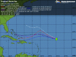
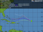
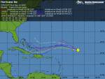
TROPICAL STORM IKE ADVISORY NUMBER 7
NWS TPC/NATIONAL HURRICANE CENTER MIAMI FL AL092008
1100 PM AST TUE SEP 02 2008
...IKE HEADING TOWARD THE WESTERN ATLANTIC...A CYCLONE TO CAREFULLY
WATCH OVER THE NEXT FEW DAYS...
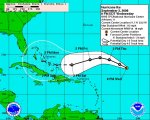
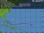
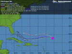
AT 1100 PM AST...0300Z...THE CENTER OF TROPICAL STORM IKE WAS
LOCATED NEAR LATITUDE 19.9 NORTH...LONGITUDE 47.9 WEST OR ABOUT 930
MILES...1500 KM...EAST-NORTHEAST OF THE LEEWARD ISLANDS.
IKE IS MOVING TOWARD THE WEST-NORTHWEST NEAR 17 MPH...28 KM/HR. A
MOTION BETWEEN THE WEST-NORTHWEST AND WEST WITH LITTLE CHANGE IN
FORWARD SPEED IS EXPECTED DURING THE NEXT FEW DAYS.
MAXIMUM SUSTAINED WINDS ARE NEAR 65 MPH...100 KM/HR...WITH HIGHER
GUSTS. SOME STRENGTHENING IS FORECAST DURING THE NEXT 24 HOURS AND
IKE COULD BECOME A HURRICANE ON WEDNESDAY.
TROPICAL STORM FORCE WINDS EXTEND OUTWARD UP TO 140 MILES...220 KM
FROM THE CENTER.
ESTIMATED MINIMUM CENTRAL PRESSURE IS 996 MB...29.41 INCHES.
REPEATING THE 1100 PM AST POSITION...19.9 N...47.9 W. MOVEMENT
TOWARD...WEST-NORTHWEST NEAR 17 MPH. MAXIMUM SUSTAINED WINDS...65
MPH. MINIMUM CENTRAL PRESSURE...996 MB.
THE NEXT ADVISORY WILL BE ISSUED BY THE NATIONAL HURRICANE CENTER AT
500 AM AST.
$$
FORECASTER AVILA
WTNT34 KNHC 030249
TCPAT4
BULLETIN
TROPICAL STORM IKE ADVISORY NUMBER 7
NWS TPC/NATIONAL HURRICANE CENTER MIAMI FL AL092008
1100 PM AST TUE SEP 02 2008
...IKE HEADING TOWARD THE WESTERN ATLANTIC...A CYCLONE TO CAREFULLY
WATCH OVER THE NEXT FEW DAYS...
AT 1100 PM AST...0300Z...THE CENTER OF TROPICAL STORM IKE WAS
LOCATED NEAR LATITUDE 19.9 NORTH...LONGITUDE 47.9 WEST OR ABOUT 930
MILES...1500 KM...EAST-NORTHEAST OF THE LEEWARD ISLANDS.
IKE IS MOVING TOWARD THE WEST-NORTHWEST NEAR 17 MPH...28 KM/HR. A
MOTION BETWEEN THE WEST-NORTHWEST AND WEST WITH LITTLE CHANGE IN
FORWARD SPEED IS EXPECTED DURING THE NEXT FEW DAYS.
MAXIMUM SUSTAINED WINDS ARE NEAR 65 MPH...100 KM/HR...WITH HIGHER
GUSTS. SOME STRENGTHENING IS FORECAST DURING THE NEXT 24 HOURS AND
IKE COULD BECOME A HURRICANE ON WEDNESDAY.
TROPICAL STORM FORCE WINDS EXTEND OUTWARD UP TO 140 MILES...220 KM
FROM THE CENTER.
ESTIMATED MINIMUM CENTRAL PRESSURE IS 996 MB...29.41 INCHES.
REPEATING THE 1100 PM AST POSITION...19.9 N...47.9 W. MOVEMENT
TOWARD...WEST-NORTHWEST NEAR 17 MPH. MAXIMUM SUSTAINED WINDS...65
MPH. MINIMUM CENTRAL PRESSURE...996 MB.
THE NEXT ADVISORY WILL BE ISSUED BY THE NATIONAL HURRICANE CENTER AT
500 AM AST.
$$
FORECASTER AVILA
Jarhead
Has No Life - Lives on TB
000
WTNT44 KNHC 030251
TCDAT4
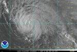
TROPICAL STORM IKE DISCUSSION NUMBER 7
NWS TPC/NATIONAL HURRICANE CENTER MIAMI FL AL092008
1100 PM EDT TUE SEP 02 2008
THE OVERALL CLOUD PATTERN IS A LITTLE MORE SYMMETRIC AND THE OUTFLOW
IS EXCELLENT IN ALL QUADRANTS. HOWEVER...IKE LACKS AN INNER CORE
AND DEEP CONVECTION IS LIMITED TO A CYCLONICALLY CURVED BAND MAINLY
TO THE WEST OF THE CENTER. AN EARLIER QUIKSCAT PASS DID NOT SHOW
ANY WINDS HIGHER THAN 45 KNOTS BUT DVORAK T-NUMBERS CONTINUE TO
SUGGEST THAT THE WINDS ARE 55 KNOTS..AND THIS NUMBER IS USED FOR THE
INITIAL INTENSITY. SINCE THE SHEAR IS EXPECTED TO BE LIGHT FOR A
DAY OR SO...A GRADUAL INTENSIFICATION IS FORECAST AND IKE COULD
BECOME A HURRICANE ANYTIME SOON. IN 2 TO 3 DAYS... A STRONG
EASTERLY SHEAR IS FORECAST TO DEVELOP AND COULD DELAY THE
INTENSIFICATION PROCESS. HOWEVER...EASTERLY SHEAR IS NOT AS
NEGATIVE AS WESTERLY SHEAR FOR A CYCLONE TO INTENSIFY. ALTHOUGH
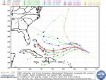
BOTH GFDL AND HWRF MAKE IKE AN INTENSE CYCLONE IN THE VICINITY OF
THE BAHAMAS IN FIVE DAYS...THE OFFICIAL FORECAST IS MORE
MODERATE...AND IS A BLEND OF THE SHIPS AND THE DYNAMICAL MODELS.
IKE IS SOUTH OF A STRONG SUBTROPICAL RIDGE AND IS MOVING TOWARD THE
WEST-NORTHWEST OR 285 DEGREES AT 15 KNOTS. GLOBAL MODELS EXPAND AND
BUILD THE RIDGE WESTWARD...AND THIS PATTERN SHOULD FORCE IKE ON A
GENERAL WESTWARD TRACK. THE RIDGE BECOMES SO STRONG BY THE END OF
THE FORECAST PERIOD THAT MODELS TURN IKE ON A SLIGHT WEST-SOUTHWEST
TRACK. THIS SHIFT IS REFLECTED IN THE OFFICIAL FORECAST. WITH THE
EXCEPTION OF THE UK MODEL...WHICH MOVES IKE WITH A MORE
WEST-NORTHWEST TRACK...THE REST OF THE GUIDANCE IS TIGHTLY
CLUSTERED PLACING THE CYCLONE IN THE SOUTH/CENTRAL BAHAMAS IN FIVE
DAYS. THE FACT THAT MOST OF THE DYNAMICAL MODELS ARE IN GOOD
AGREEMENT INCREASES THE CONFIDENCE IN THE TRACK FORECAST.
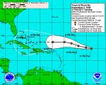
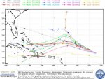
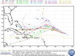
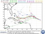
FORECAST POSITIONS AND MAX WINDS
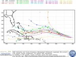
INITIAL 03/0300Z 19.9N 47.9W 55 KT
12HR VT 03/1200Z 20.3N 50.3W 65 KT
24HR VT 04/0000Z 21.0N 53.5W 70 KT
36HR VT 04/1200Z 22.0N 56.5W 75 KT
48HR VT 05/0000Z 22.5N 59.5W 80 KT
72HR VT 06/0000Z 22.5N 64.5W 85 KT
96HR VT 07/0000Z 22.5N 70.0W 90 KT
120HR VT 08/0000Z 22.1N 76.0W 95 KT
$$
FORECASTER AVILA
.
WTNT44 KNHC 030251
TCDAT4
TROPICAL STORM IKE DISCUSSION NUMBER 7
NWS TPC/NATIONAL HURRICANE CENTER MIAMI FL AL092008
1100 PM EDT TUE SEP 02 2008
THE OVERALL CLOUD PATTERN IS A LITTLE MORE SYMMETRIC AND THE OUTFLOW
IS EXCELLENT IN ALL QUADRANTS. HOWEVER...IKE LACKS AN INNER CORE
AND DEEP CONVECTION IS LIMITED TO A CYCLONICALLY CURVED BAND MAINLY
TO THE WEST OF THE CENTER. AN EARLIER QUIKSCAT PASS DID NOT SHOW
ANY WINDS HIGHER THAN 45 KNOTS BUT DVORAK T-NUMBERS CONTINUE TO
SUGGEST THAT THE WINDS ARE 55 KNOTS..AND THIS NUMBER IS USED FOR THE
INITIAL INTENSITY. SINCE THE SHEAR IS EXPECTED TO BE LIGHT FOR A
DAY OR SO...A GRADUAL INTENSIFICATION IS FORECAST AND IKE COULD
BECOME A HURRICANE ANYTIME SOON. IN 2 TO 3 DAYS... A STRONG
EASTERLY SHEAR IS FORECAST TO DEVELOP AND COULD DELAY THE
INTENSIFICATION PROCESS. HOWEVER...EASTERLY SHEAR IS NOT AS
NEGATIVE AS WESTERLY SHEAR FOR A CYCLONE TO INTENSIFY. ALTHOUGH
BOTH GFDL AND HWRF MAKE IKE AN INTENSE CYCLONE IN THE VICINITY OF
THE BAHAMAS IN FIVE DAYS...THE OFFICIAL FORECAST IS MORE
MODERATE...AND IS A BLEND OF THE SHIPS AND THE DYNAMICAL MODELS.
IKE IS SOUTH OF A STRONG SUBTROPICAL RIDGE AND IS MOVING TOWARD THE
WEST-NORTHWEST OR 285 DEGREES AT 15 KNOTS. GLOBAL MODELS EXPAND AND
BUILD THE RIDGE WESTWARD...AND THIS PATTERN SHOULD FORCE IKE ON A
GENERAL WESTWARD TRACK. THE RIDGE BECOMES SO STRONG BY THE END OF
THE FORECAST PERIOD THAT MODELS TURN IKE ON A SLIGHT WEST-SOUTHWEST
TRACK. THIS SHIFT IS REFLECTED IN THE OFFICIAL FORECAST. WITH THE
EXCEPTION OF THE UK MODEL...WHICH MOVES IKE WITH A MORE
WEST-NORTHWEST TRACK...THE REST OF THE GUIDANCE IS TIGHTLY
CLUSTERED PLACING THE CYCLONE IN THE SOUTH/CENTRAL BAHAMAS IN FIVE
DAYS. THE FACT THAT MOST OF THE DYNAMICAL MODELS ARE IN GOOD
AGREEMENT INCREASES THE CONFIDENCE IN THE TRACK FORECAST.
FORECAST POSITIONS AND MAX WINDS
INITIAL 03/0300Z 19.9N 47.9W 55 KT
12HR VT 03/1200Z 20.3N 50.3W 65 KT
24HR VT 04/0000Z 21.0N 53.5W 70 KT
36HR VT 04/1200Z 22.0N 56.5W 75 KT
48HR VT 05/0000Z 22.5N 59.5W 80 KT
72HR VT 06/0000Z 22.5N 64.5W 85 KT
96HR VT 07/0000Z 22.5N 70.0W 90 KT
120HR VT 08/0000Z 22.1N 76.0W 95 KT
$$
FORECASTER AVILA
.
Attachments
Jarhead
Has No Life - Lives on TB
000
WTNT34 KNHC 030834
TCPAT4
BULLETIN
TROPICAL STORM IKE ADVISORY NUMBER 8
NWS TPC/NATIONAL HURRICANE CENTER MIAMI FL AL092008
500 AM AST WED SEP 03 2008
...IKE CONTINUES WEST-NORTHWESTWARD...HAS NOT STRENGTHENED
RECENTLY...
AT 500 AM AST...0900Z...THE CENTER OF TROPICAL STORM IKE WAS LOCATED
NEAR LATITUDE 20.6 NORTH...LONGITUDE 49.6 WEST OR ABOUT 835 MILES...
1340 KM...EAST-NORTHEAST OF THE LEEWARD ISLANDS.
IKE IS MOVING TOWARD THE WEST-NORTHWEST NEAR 18 MPH...30 KM/HR...AND
A GRADUAL TURN TOWARD THE WEST IS EXPECTED OVER THE NEXT 48 HOURS.
SATELLITE IMAGES INDICATE THAT THE MAXIMUM SUSTAINED WINDS REMAIN
NEAR 65 MPH...100 KM/HR...WITH HIGHER GUSTS. IKE IS FORECAST TO
BECOME A HURRICANE LATER TODAY...AND CONTINUE TO STRENGTHEN OVER THE
NEXT COUPLE OF DAYS.
TROPICAL STORM FORCE WINDS EXTEND OUTWARD UP TO 140 MILES...220 KM
FROM THE CENTER.
ESTIMATED MINIMUM CENTRAL PRESSURE IS 996 MB...29.41 INCHES.
REPEATING THE 500 AM AST POSITION...20.6 N...49.6 W. MOVEMENT
TOWARD...WEST-NORTHWEST NEAR 18 MPH. MAXIMUM SUSTAINED WINDS...65
MPH. MINIMUM CENTRAL PRESSURE...996 MB.
THE NEXT ADVISORY WILL BE ISSUED BY THE NATIONAL HURRICANE CENTER AT
1100 AM AST.
$$
FORECASTER PASCH
Jarhead
Has No Life - Lives on TB
000
WTNT44 KNHC 030835
TCDAT4
TROPICAL STORM IKE DISCUSSION NUMBER 8
NWS TPC/NATIONAL HURRICANE CENTER MIAMI FL AL092008
500 AM EDT WED SEP 03 2008
IKE'S CLOUD PATTERN HAS NOT CHANGED SIGNIFICANTLY IN ORGANIZATION
AND UPPER-LEVEL OUTFLOW REMAINS FAIRLY STRONG AROUND THE
STORM...WITH AN OUTFLOW CHANNEL DEVELOPING OVER THE SOUTHEAST
QUADRANT. THE TROPICAL CYCLONE CONTINUES TO LACK A WELL-DEFINED
INNER CORE AND...UNTIL THIS INNER CORE BECOMES ESTABLISHED...
STRENGTHENING WILL BE SLOW. HOWEVER...ONCE AN EYEWALL BECOMES
DEFINED THE RATE OF INTENSIFICATION SHOULD INCREASE. THE ONLY
OBVIOUS IMPEDIMENT TO STRENGTHENING IS AN INCREASE IN NORTHEASTERLY
SHEAR AROUND 48 HOURS AS FORECAST BY THE GLOBAL MODELS. THE
OFFICIAL INTENSITY FORECAST IS THE SAME AS IN THE PREVIOUS
ADVISORY. THIS IS NEAR THE HIGH END OF MUCH OF OUR NUMERICAL
GUIDANCE...ALTHOUGH THE HWRF SHOWS A SIGNIFICANTLY STRONGER
HURRICANE NEAR THE END OF THE PERIOD.
THERE HAS BEEN SOME SLIGHT ACCELERATION AND THE LATEST GEOSTATIONARY
SATELLITE AND MICROWAVE FIXES REQUIRE A BIT OF A NORTHWARD
ADJUSTMENT TO THE TRACK. INITIAL MOTION IS AROUND 285/16. THE
TRACK FORECAST FOR THE NEXT 1-2 DAYS SEEMS STRAIGHTFORWARD AS A
SUBTROPICAL RIDGE TO THE NORTH OF IKE CONTINUES TO PUSH THE STORM
TOWARD THE WEST-NORTHWEST AND WEST. LATER IN THE FORECAST
PERIOD...THERE IS MORE UNCERTAINTY. THE GLOBAL MODELS DEPICT A
BUILDING OF THE MID-TROPOSPHERIC RIDGE TO THE NORTH AND NORTHWEST
OF IKE IN 3 TO 5 DAYS...AND THIS WOULD FORCE A TURN TOWARD THE
LEFT. HOWEVER THE TRACK MODELS DIFFER ON HOW MUCH THE TROPICAL
CYCLONE WILL TURN. THE GFDL AND DEEP-LAYER BAM ARE THE
SOUTHERNMOST AND BRING IKE OVER HISPANIOLA WHEREAS THE U.K. MET
OFFICE GLOBAL MODEL...WHICH IS ALSO A CREDIBLE MODEL...TAKES THE
CYCLONE TO MUCH HIGHER LATITUDES. ASIDE FROM A SLIGHT NORTHWARD
ADJUSTMENT TO ACCOUNT FOR THE NORTHWARD SHIFT OF THE RECENT
TRACK...THE OFFICIAL FORECAST IS QUITE SIMILAR TO THE PREVIOUS ONE
AND LIES NEAR THE LATEST DYNAMICAL TRACK MODEL CONSENSUS.
FORECAST POSITIONS AND MAX WINDS
INITIAL 03/0900Z 20.6N 49.6W 55 KT
12HR VT 03/1800Z 21.3N 52.2W 65 KT
24HR VT 04/0600Z 22.2N 55.1W 70 KT
36HR VT 04/1800Z 22.8N 58.0W 75 KT
48HR VT 05/0600Z 23.2N 60.8W 80 KT
72HR VT 06/0600Z 23.0N 66.0W 85 KT
96HR VT 07/0600Z 22.5N 71.0W 90 KT
120HR VT 08/0600Z 22.5N 76.0W 95 KT
$$
FORECASTER PASCH
Attachments

Jarhead
Has No Life - Lives on TB
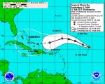
Crown Weather Services
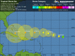
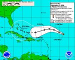
Tropical Weather Discussion
Issued: Wednesday, September 3, 2008 545 am EDT
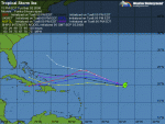
Tropical Storm Ike:
Ike continues to maintain an excellent satellite presentation and banding features have become more organized in a centralized area of deep convection. In addition, the entire system is rather symmetrical in shape. Ike has maximum sustained winds of 65 mph and it appears that the environmental conditions are quite favorable for development ahead of Ike. A ridge of high pressure near Ike is now located to the southeast of the storm and is providing divergence aloft. Wind shear values are 10 knots or less and these wind shear values are forecast to remain at 10 knots or less right into this weekend. I expect steady intensification for the next several days and Ike may be a Category 3 hurricane by Monday morning.
Ike is tracking to the west-northwest at a forward speed of 18 mph. The track forecast for the next couple of days is pretty straightforward as a ridge of high pressure to the north of Ike will push the storm on a west to west-northwest course. By this weekend, there is more uncertainty. The global models depict a building of a ridge of high pressure to the north and northwest of Ike this weekend and this would force a turn toward the west-southwest and perhaps even southwest. The track model guidance differ on how much the storm will turn. The GFDL and BAMD models are the southernmost and bring Ike over Hispaniola, whereas the UKMET model takes Ike to a much higher latitude. The model consensus forecasts Ike to be located in the southeastern Bahamas by late this weekend into early next week and this may end up being close to reality.
The next tropical weather discussion will be issued by 7 am EDT Thursday morning.
Prepared by Rob Lightbown, Crown Weather Services
Disclaimer: All forecasts herein are made to the best ability of the forecaster.
Tropical Weather Discussion
Issued: Wednesday, September 3, 2008 545 am EDT
Tropical Storm Ike:
Ike continues to maintain an excellent satellite presentation and banding features have become more organized in a centralized area of deep convection. In addition, the entire system is rather symmetrical in shape. Ike has maximum sustained winds of 65 mph and it appears that the environmental conditions are quite favorable for development ahead of Ike. A ridge of high pressure near Ike is now located to the southeast of the storm and is providing divergence aloft. Wind shear values are 10 knots or less and these wind shear values are forecast to remain at 10 knots or less right into this weekend. I expect steady intensification for the next several days and Ike may be a Category 3 hurricane by Monday morning.
Ike is tracking to the west-northwest at a forward speed of 18 mph. The track forecast for the next couple of days is pretty straightforward as a ridge of high pressure to the north of Ike will push the storm on a west to west-northwest course. By this weekend, there is more uncertainty. The global models depict a building of a ridge of high pressure to the north and northwest of Ike this weekend and this would force a turn toward the west-southwest and perhaps even southwest. The track model guidance differ on how much the storm will turn. The GFDL and BAMD models are the southernmost and bring Ike over Hispaniola, whereas the UKMET model takes Ike to a much higher latitude. The model consensus forecasts Ike to be located in the southeastern Bahamas by late this weekend into early next week and this may end up being close to reality.
The next tropical weather discussion will be issued by 7 am EDT Thursday morning.
Prepared by Rob Lightbown, Crown Weather Services
Disclaimer: All forecasts herein are made to the best ability of the forecaster.
Jarhead
Has No Life - Lives on TB
000
WTNT34 KNHC 031442
TCPAT4
BULLETIN
TROPICAL STORM IKE ADVISORY NUMBER 9
NWS TPC/NATIONAL HURRICANE CENTER MIAMI FL AL092008
1100 AM AST WED SEP 03 2008
...IKE ALMOST A HURRICANE...
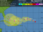
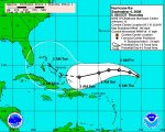
AT 1100 AM AST...1500Z...THE CENTER OF TROPICAL STORM IKE WAS
LOCATED NEAR LATITUDE 20.8 NORTH...LONGITUDE 51.2 WEST OR ABOUT 740
MILES...1190 KM...EAST-NORTHEAST OF THE LEEWARD ISLANDS.
IKE IS MOVING TOWARD THE WEST-NORTHWEST NEAR 18 MPH...30 KM/HR...AND
THIS GENERAL MOTION IS EXPECTED TO CONTINUE THROUGH THURSDAY...
FOLLOWED BY A TURN TO THE WEST ON FRIDAY...TAKING IKE
OVER THE OPEN WATERS OF THE WEST-CENTRAL ATLANTIC DURING THE NEXT
COUPLE OF DAYS. IT IS TOO EARLY TO DETERMINE WHAT IF ANY LAND AREAS
MIGHT BE DIRECTLY AFFECTED BY IKE.
MAXIMUM SUSTAINED WINDS HAVE INCREASED TO NEAR 70 MPH...110
KM/HR...WITH HIGHER GUSTS. STRENGTHENING IS FORECAST DURING THE
NEXT DAY OR TWO...AND IKE IS FORECAST TO BECOME A HURRICANE LATER
TODAY.
TROPICAL STORM FORCE WINDS EXTEND OUTWARD UP TO 140 MILES...220 KM
FROM THE CENTER.
ESTIMATED MINIMUM CENTRAL PRESSURE IS 991 MB...29.26 INCHES.
REPEATING THE 1100 AM AST POSITION...20.8 N...51.2 W. MOVEMENT
TOWARD...WEST-NORTHWEST NEAR 18 MPH. MAXIMUM SUSTAINED WINDS...70
MPH. MINIMUM CENTRAL PRESSURE...991 MB.
THE NEXT ADVISORY WILL BE ISSUED BY THE NATIONAL HURRICANE CENTER AT
500 PM AST.
$$
FORECASTER KNABB
WTNT34 KNHC 031442
TCPAT4
BULLETIN
TROPICAL STORM IKE ADVISORY NUMBER 9
NWS TPC/NATIONAL HURRICANE CENTER MIAMI FL AL092008
1100 AM AST WED SEP 03 2008
...IKE ALMOST A HURRICANE...
AT 1100 AM AST...1500Z...THE CENTER OF TROPICAL STORM IKE WAS
LOCATED NEAR LATITUDE 20.8 NORTH...LONGITUDE 51.2 WEST OR ABOUT 740
MILES...1190 KM...EAST-NORTHEAST OF THE LEEWARD ISLANDS.
IKE IS MOVING TOWARD THE WEST-NORTHWEST NEAR 18 MPH...30 KM/HR...AND
THIS GENERAL MOTION IS EXPECTED TO CONTINUE THROUGH THURSDAY...
FOLLOWED BY A TURN TO THE WEST ON FRIDAY...TAKING IKE
OVER THE OPEN WATERS OF THE WEST-CENTRAL ATLANTIC DURING THE NEXT
COUPLE OF DAYS. IT IS TOO EARLY TO DETERMINE WHAT IF ANY LAND AREAS
MIGHT BE DIRECTLY AFFECTED BY IKE.
MAXIMUM SUSTAINED WINDS HAVE INCREASED TO NEAR 70 MPH...110
KM/HR...WITH HIGHER GUSTS. STRENGTHENING IS FORECAST DURING THE
NEXT DAY OR TWO...AND IKE IS FORECAST TO BECOME A HURRICANE LATER
TODAY.
TROPICAL STORM FORCE WINDS EXTEND OUTWARD UP TO 140 MILES...220 KM
FROM THE CENTER.
ESTIMATED MINIMUM CENTRAL PRESSURE IS 991 MB...29.26 INCHES.
REPEATING THE 1100 AM AST POSITION...20.8 N...51.2 W. MOVEMENT
TOWARD...WEST-NORTHWEST NEAR 18 MPH. MAXIMUM SUSTAINED WINDS...70
MPH. MINIMUM CENTRAL PRESSURE...991 MB.
THE NEXT ADVISORY WILL BE ISSUED BY THE NATIONAL HURRICANE CENTER AT
500 PM AST.
$$
FORECASTER KNABB
Jarhead
Has No Life - Lives on TB
000
WTNT44 KNHC 031500
TCDAT4
TROPICAL STORM IKE DISCUSSION NUMBER 9
NWS TPC/NATIONAL HURRICANE CENTER MIAMI FL AL092008
1100 AM EDT WED SEP 03 2008
IKE IS WRAPPING UP SOME SOLID CONVECTIVE BANDING AS VIEWED IN
VISIBLE IMAGERY...AND SINCE A PARTIAL OVERPASS SEVERAL HOURS AGO
FROM AMSR-E SUGGESTED A MICROWAVE EYE WAS FORMING...WE MIGHT SEE AN
EYE IN THE VISIBLE BEFORE TOO MUCH LONGER. SUBJECTIVE DVORAK
T-NUMBERS AT 1200 UTC WERE A CONSENSUS 4.0...BUT OBJECTIVE NUMBERS
ARE A LITTLE LOWER...SO THE INTENSITY IS SET TO 60 KT FOR NOW. IN
ANY CASE...IKE IS ON THE CUSP OF BEING A HURRICANE AND SHOULD BE
ONE LATER TODAY. THE UNDERLYING OCEAN TEMPERATURES WILL ONLY GET
WARMER ALONG THE FORECAST TRACK...MAXIMIZING BEYOND 48 HOURS NEAR
29 CELSIUS...WHICH WOULD FAVOR A STRENGTHENING TREND THROUGHOUT THE
FIVE-DAY PERIOD. DURING THE NEXT COUPLE OF DAYS...HOWEVER...IKE
MIGHT ENCOUNTER A LITTLE INCREASE IN WIND SHEAR FROM THE NORTH
BEHIND THE MID-LATITUDE TROUGH THAT WILL BE TRAVERSING THE
NORTHWESTERN ATLANTIC. THE OBJECTIVE GUIDANCE DOES NOT FORECAST
ANY WEAKENING AS A RESULT...BUT NONE OF THE MODELS FORECAST ROBUST
STRENGTHENING...UNTIL IKE HEADS FARTHER WEST...ESCAPES THE
SHEAR...AND MOVES OVER EVEN WARMER WATERS NEAR THE GREATER
ANTILLES. STEADY STRENGTHENING IS FORECAST AT DAYS 3-5 IN LINE
WITH MOST OF THE INTENSITY MODELS...AND IKE COULD REACH MAJOR
HURRICANE STATUS BEFORE FIVE DAYS PASS.
IKE CONTINUES WEST-NORTHWESTWARD OR 285/16 ALONG THE SOUTHWESTERN
PERIPHERY OF A MID-LEVEL RIDGE OVER THE CENTRAL ATLANTIC. THE
MODELS FORECAST IKE TO BEND A LITTLE TO THE RIGHT AROUND THAT
RIDGE...BUT IN A COUPLE OF DAYS IT WILL RUN INTO A RIDGE BUILDING
OVER THE WESTERN ATLANTIC. NEARLY ALL OF THE MODELS AGREE THAT
THIS PATTERN WILL FORCE IKE WEST-SOUTHWESTWARD AND EVENTUALLY
WESTWARD AROUND THE SOUTHERN PERIPHERY OF THAT FEATURE...BUT THEY
DO NOT AGREE ON THE EXACT LATITUDE OR THE SPEED OF THAT WESTWARD
MOTION. THE CONSENSUS HAS SLOWED DOWN A LITTLE LATE IN THE
FIVE-DAY PERIOD...AND SO HAS THE OFFICIAL FORECAST TRACK...BUT
OTHERWISE THE NEW TRACK IS SIMILAR TO THE PREVIOUS ONE...EXCEPT FOR
A LITTLE MORE NORTHWARD PROGRESS WITHIN THE NEXT COUPLE OF DAYS.
FORECAST POSITIONS AND MAX WINDS
INITIAL 03/1500Z 20.8N 51.2W 60 KT
12HR VT 04/0000Z 21.7N 53.7W 65 KT
24HR VT 04/1200Z 23.1N 56.8W 70 KT
36HR VT 05/0000Z 23.8N 59.4W 70 KT
48HR VT 05/1200Z 24.0N 62.0W 70 KT
72HR VT 06/1200Z 22.5N 67.0W 80 KT
96HR VT 07/1200Z 22.0N 71.5W 90 KT
120HR VT 08/1200Z 22.5N 75.5W 100 KT
$$
FORECASTER KNABB
Attachments
Last edited:

Jarhead
Has No Life - Lives on TB
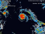
From Weather Underground....
Posted by: JeffMasters, 9:38 AM EDT on September 03, 2008
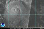
Ike
Tropical Storm Ike continues getting organized over the middle Atlantic, and has the potential to become a large and dangerous Cape Verdes-type hurricane by Monday, when it is expected to be in the southeastern Bahama Islands. Visible satellite loops show that heavy thunderstorm activity is starting to wrap around the core of the storm, and Ike has about 50% of an eyewall built. Upper-level outflow is good, and Ike is in a very favorable upper-level wind environment, with an upper-level anticyclone overhead, and wind shear less than 10 knots. Ike has moistened the atmosphere around it enough to wall off a large amount of dry air that surrounds it.
Rather cool sea surface temperatures (SSTs) of 27.5°C. SSTs will quickly warm to 29°C over the next two days, but the shear is forecast to increase to 20-35 knots Thursday through Friday. The SHIPS model responds by strengthening Ike only to a Category 1 hurricane today, then weakening it to a tropical storm during the higher shear, then strengthening it again to a Category 1 hurricane by Saturday.
The HWRF and GFDL models do not predict the shear will affect Ike as much Thursday and Friday, and intensify the storm into a Category 2 or higher hurricane by Sunday. The HWRF makes Ike a Category 4 hurricane in the eastern Bahama Islands on Monday, and the GFDL has Ike hitting eastern Cuba as a Category 2 or 3 hurricane on Monday. I expect Ike to be a hurricane by Thursday morning, and a Category 3 or higher hurricane by Monday.
The longer term fate of Ike is highly uncertain. The ECMWF and GFS models both forecast that Hanna will be strong enough to create a weakness in the ridge of high pressure steering Ike to the west. Ike will then follow Hanna's path, recurving northwards. the timing of this recurvature is critical, as the GFS shows that Ike will miss the U.S., while the ECMWF forecasts a strike in South Florida on Tuesday, then another landfall in North Carolina later in the week. If Hanna is not as strong or is faster-moving than these models expect, Ike may not recurve. Instead, Ike will cross Cuba or move through the Florida Straits, eventually emerging into the Gulf of Mexico to cause havoc there. This is my current expectation.
Posted by: JeffMasters, 9:38 AM EDT on September 03, 2008
Ike
Tropical Storm Ike continues getting organized over the middle Atlantic, and has the potential to become a large and dangerous Cape Verdes-type hurricane by Monday, when it is expected to be in the southeastern Bahama Islands. Visible satellite loops show that heavy thunderstorm activity is starting to wrap around the core of the storm, and Ike has about 50% of an eyewall built. Upper-level outflow is good, and Ike is in a very favorable upper-level wind environment, with an upper-level anticyclone overhead, and wind shear less than 10 knots. Ike has moistened the atmosphere around it enough to wall off a large amount of dry air that surrounds it.
Rather cool sea surface temperatures (SSTs) of 27.5°C. SSTs will quickly warm to 29°C over the next two days, but the shear is forecast to increase to 20-35 knots Thursday through Friday. The SHIPS model responds by strengthening Ike only to a Category 1 hurricane today, then weakening it to a tropical storm during the higher shear, then strengthening it again to a Category 1 hurricane by Saturday.
The HWRF and GFDL models do not predict the shear will affect Ike as much Thursday and Friday, and intensify the storm into a Category 2 or higher hurricane by Sunday. The HWRF makes Ike a Category 4 hurricane in the eastern Bahama Islands on Monday, and the GFDL has Ike hitting eastern Cuba as a Category 2 or 3 hurricane on Monday. I expect Ike to be a hurricane by Thursday morning, and a Category 3 or higher hurricane by Monday.
The longer term fate of Ike is highly uncertain. The ECMWF and GFS models both forecast that Hanna will be strong enough to create a weakness in the ridge of high pressure steering Ike to the west. Ike will then follow Hanna's path, recurving northwards. the timing of this recurvature is critical, as the GFS shows that Ike will miss the U.S., while the ECMWF forecasts a strike in South Florida on Tuesday, then another landfall in North Carolina later in the week. If Hanna is not as strong or is faster-moving than these models expect, Ike may not recurve. Instead, Ike will cross Cuba or move through the Florida Straits, eventually emerging into the Gulf of Mexico to cause havoc there. This is my current expectation.


Jarhead
Has No Life - Lives on TB
000
WTNT34 KNHC 032046
TCPAT4
BULLETIN
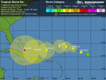
HURRICANE IKE ADVISORY NUMBER 10
NWS TPC/NATIONAL HURRICANE CENTER MIAMI FL AL092008
500 PM AST WED SEP 03 2008
...IKE BECOMES THE FIFTH HURRICANE OF THE 2008 ATLANTIC SEASON...
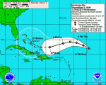
AT 500 PM AST...2100Z...THE CENTER OF HURRICANE IKE WAS LOCATED NEAR
LATITUDE 21.6 NORTH...LONGITUDE 52.7 WEST OR ABOUT 670 MILES...1080
KM...EAST-NORTHEAST OF THE LEEWARD ISLANDS.
IKE IS MOVING TOWARD THE WEST-NORTHWEST NEAR 18 MPH...30
KM/HR....AND THIS GENERAL MOTION IS EXPECTED TO CONTINUE TONIGHT
AND EARLY THURSDAY...FOLLOWED BY A TURN TO THE WEST ON THURSDAY
NIGHT AND FRIDAY...TAKING IKE OVER THE OPEN WATERS OF THE
WEST-CENTRAL ATLANTIC DURING THE NEXT COUPLE OF DAYS. IT IS TOO
EARLY TO DETERMINE WHAT IF ANY LAND AREAS MIGHT EVENTUALLY BE
AFFECTED BY IKE.
MAXIMUM SUSTAINED WINDS HAVE INCREASED TO NEAR 80 MPH...130
KM/HR...WITH HIGHER GUSTS. IKE IS A CATEGORY ONE HURRICANE ON THE
SAFFIR-SIMPSON HURRICANE SCALE. SOME ADDITIONAL STRENGTHENING IS
FORECAST DURING THE NEXT DAY OR TWO.
HURRICANE FORCE WINDS EXTEND OUTWARD UP TO 35 MILES...55 KM...FROM
THE CENTER...AND TROPICAL STORM FORCE WINDS EXTEND OUTWARD UP TO 160
MILES...260 KM.
THE ESTIMATED MINIMUM CENTRAL PRESSURE IS 984 MB...29.06 INCHES.
REPEATING THE 500 PM AST POSITION...21.6 N...52.7 W. MOVEMENT
TOWARD...WEST-NORTHWEST NEAR 18 MPH. MAXIMUM SUSTAINED WINDS...80
MPH. MINIMUM CENTRAL PRESSURE...984 MB.
THE NEXT ADVISORY WILL BE ISSUED BY THE NATIONAL HURRICANE CENTER AT
1100 PM AST.
$$
FORECASTER KNABB
WTNT34 KNHC 032046
TCPAT4
BULLETIN
HURRICANE IKE ADVISORY NUMBER 10
NWS TPC/NATIONAL HURRICANE CENTER MIAMI FL AL092008
500 PM AST WED SEP 03 2008
...IKE BECOMES THE FIFTH HURRICANE OF THE 2008 ATLANTIC SEASON...
AT 500 PM AST...2100Z...THE CENTER OF HURRICANE IKE WAS LOCATED NEAR
LATITUDE 21.6 NORTH...LONGITUDE 52.7 WEST OR ABOUT 670 MILES...1080
KM...EAST-NORTHEAST OF THE LEEWARD ISLANDS.
IKE IS MOVING TOWARD THE WEST-NORTHWEST NEAR 18 MPH...30
KM/HR....AND THIS GENERAL MOTION IS EXPECTED TO CONTINUE TONIGHT
AND EARLY THURSDAY...FOLLOWED BY A TURN TO THE WEST ON THURSDAY
NIGHT AND FRIDAY...TAKING IKE OVER THE OPEN WATERS OF THE
WEST-CENTRAL ATLANTIC DURING THE NEXT COUPLE OF DAYS. IT IS TOO
EARLY TO DETERMINE WHAT IF ANY LAND AREAS MIGHT EVENTUALLY BE
AFFECTED BY IKE.
MAXIMUM SUSTAINED WINDS HAVE INCREASED TO NEAR 80 MPH...130
KM/HR...WITH HIGHER GUSTS. IKE IS A CATEGORY ONE HURRICANE ON THE
SAFFIR-SIMPSON HURRICANE SCALE. SOME ADDITIONAL STRENGTHENING IS
FORECAST DURING THE NEXT DAY OR TWO.
HURRICANE FORCE WINDS EXTEND OUTWARD UP TO 35 MILES...55 KM...FROM
THE CENTER...AND TROPICAL STORM FORCE WINDS EXTEND OUTWARD UP TO 160
MILES...260 KM.
THE ESTIMATED MINIMUM CENTRAL PRESSURE IS 984 MB...29.06 INCHES.
REPEATING THE 500 PM AST POSITION...21.6 N...52.7 W. MOVEMENT
TOWARD...WEST-NORTHWEST NEAR 18 MPH. MAXIMUM SUSTAINED WINDS...80
MPH. MINIMUM CENTRAL PRESSURE...984 MB.
THE NEXT ADVISORY WILL BE ISSUED BY THE NATIONAL HURRICANE CENTER AT
1100 PM AST.
$$
FORECASTER KNABB
Jarhead
Has No Life - Lives on TB
000
WTNT44 KNHC 032100
TCDAT4
HURRICANE IKE DISCUSSION NUMBER 10
NWS TPC/NATIONAL HURRICANE CENTER MIAMI FL AL092008
500 PM EDT WED SEP 03 2008
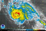
AS ANTICIPATED...IKE HAS CONTINUED TO STRENGTHEN AND ALL
SATELLITE-BASED ESTIMATES SAY IT HAS BECOME A HURRICANE. SINCE THE
1800 UTC DVORAK ESTIMATES OF 65 KT...AN EYE HAS BECOME APPARENT IN
LATE-DAY VISIBLE IMAGERY...SO THE INTENSITY IS SET TO 70 KT. THE
CYCLONE IS INTENSIFYING WITHIN A COCOON OF NEARLY ZERO VERTICAL
WIND SHEAR...IN BETWEEN THE DEEP-LAYER LOW OVER THE NORTHWESTERN
ATLANTIC AND AN UPPER-LEVEL TROUGH DOMINATING THE EASTERN PORTION
OF THE BASIN. WATER VAPOR IMAGERY REVEALS THAT THE UPPER-LEVEL
NORTHERLIES ALONG THE WESTERN FLANK OF THE EASTERN TROUGH ARE
STARTING TO JUST SLIGHTLY RESTRICT IKE'S OUTFLOW. GLOBAL MODELS
FORECAST THE SHEAR TO INCREASE FROM THE EAST...BUT PROBABLY NOT
QUICKLY ENOUGH TO HALT IKE'S INTENSIFICATION TREND IN THE SHORT
TERM. THE NEW OFFICIAL FORECAST SHOWS AN INTERMEDIATE INTENSITY
PEAK AT 24 HOURS PRIOR TO THE ONSET OF THE SHEAR...FOLLOWED BY
SLIGHT WEAKENING UNTIL THE SHEAR ABATES AFTER IKE GETS FARTHER
WEST. BY THAT TIME...IN ABOUT 72 HOURS...OCEAN AND ATMOSPHERIC
FACTORS BECOME QUITE CONDUCIVE FOR INTENSIFICATION...AND THE
DYNAMICAL MODELS GFDL AND HWRF...FORECAST A MAJOR HURRICANE BY DAYS
4 AND 5...WHICH IS ALSO SHOWN IN THE OFFICIAL FORECAST. LONG-RANGE
INTENSITY FORECASTS ARE RATHER UNCERTAIN...HOWEVER...AND THE
INTENSITY PROBABILITY TABLE INCLUDED IN THIS ADVISORY PACKAGE
INDICATES THAT THERE IS ROUGHLY A 50 PERCENT CHANCE THAT IKE WILL
BE A MAJOR HURRICANE FOUR AND FIVE DAYS FROM NOW. IF IKE IS WEAKER
THAN THE OFFICIAL FORECAST AT DAYS 3-5...THEN THE
STATISTICAL-DYNAMICAL MODELS SHIPS AND LGEM WILL TURN OUT TO BE
MORE ACCURATE.
THE HURRICANE CONTINUES HEADING WEST-NORTHWESTWARD OR 290/16. AS
THE LARGE AND DEEP-LAYER LOW CURRENTLY JUST OFF THE NORTHEAST
U.S. COAST DEPARTS TO THE NORTHEAST...MID-LEVEL RIDGING WILL BUILD
OVER THE WESTERN ATLANTIC...WHICH WILL PUSH IKE GENERALLY WESTWARD
DURING THE NEXT SEVERAL DAYS. UNDULATIONS IN THE TRACK ARE
LIKELY THOUGH. IKE SHOULD CONTINUE WEST-NORTHWESTWARD UNTIL THE
WESTERN ATLANTIC RIDGE FORMS...AFTER WHICH THE TROPICAL CYCLONE
WILL GRADUALLY ROUND THAT RIDGE. THE BIG QUESTION AT LONGER RANGES
IS IF AND WHEN IKE WILL ROTATE AROUND THE WESTERN PERIPHERY OF THAT
RIDGE...WHICH WILL DETERMINE WHETHER IKE DIRECTLY AFFECTS ANY LAND
AREAS. THE MODELS DO NOT PROVIDE AN UNANIMOUS ANSWER...WHICH IS
NOT SURPRISING THIS FAR IN ADVANCE. ALL OF THE MODELS DO SHOW THE
BEGINNINGS OF A MOTION NORTH OF DUE WEST BY DAY 5...BUT IT IS TOO
EARLY TO DETERMINE IF THIS IS THE START OF RECURVATURE...OR IF
ENOUGH RIDGING WILL REMAIN BEYOND DAY 5 TO KEEP IKE MOVING
GENERALLY WESTWARD.
FORECAST POSITIONS AND MAX WINDS
INITIAL 03/2100Z 21.6N 52.7W 70 KT
12HR VT 04/0600Z 22.6N 55.1W 75 KT
24HR VT 04/1800Z 23.8N 57.9W 85 KT
36HR VT 05/0600Z 24.3N 60.4W 80 KT
48HR VT 05/1800Z 23.8N 63.1W 80 KT
72HR VT 06/1800Z 22.5N 68.0W 90 KT
96HR VT 07/1800Z 22.5N 72.0W 100 KT
120HR VT 08/1800Z 23.5N 76.0W 100 KT
$$
FORECASTER KNABB
WTNT44 KNHC 032100
TCDAT4
HURRICANE IKE DISCUSSION NUMBER 10
NWS TPC/NATIONAL HURRICANE CENTER MIAMI FL AL092008
500 PM EDT WED SEP 03 2008
AS ANTICIPATED...IKE HAS CONTINUED TO STRENGTHEN AND ALL
SATELLITE-BASED ESTIMATES SAY IT HAS BECOME A HURRICANE. SINCE THE
1800 UTC DVORAK ESTIMATES OF 65 KT...AN EYE HAS BECOME APPARENT IN
LATE-DAY VISIBLE IMAGERY...SO THE INTENSITY IS SET TO 70 KT. THE
CYCLONE IS INTENSIFYING WITHIN A COCOON OF NEARLY ZERO VERTICAL
WIND SHEAR...IN BETWEEN THE DEEP-LAYER LOW OVER THE NORTHWESTERN
ATLANTIC AND AN UPPER-LEVEL TROUGH DOMINATING THE EASTERN PORTION
OF THE BASIN. WATER VAPOR IMAGERY REVEALS THAT THE UPPER-LEVEL
NORTHERLIES ALONG THE WESTERN FLANK OF THE EASTERN TROUGH ARE
STARTING TO JUST SLIGHTLY RESTRICT IKE'S OUTFLOW. GLOBAL MODELS
FORECAST THE SHEAR TO INCREASE FROM THE EAST...BUT PROBABLY NOT
QUICKLY ENOUGH TO HALT IKE'S INTENSIFICATION TREND IN THE SHORT
TERM. THE NEW OFFICIAL FORECAST SHOWS AN INTERMEDIATE INTENSITY
PEAK AT 24 HOURS PRIOR TO THE ONSET OF THE SHEAR...FOLLOWED BY
SLIGHT WEAKENING UNTIL THE SHEAR ABATES AFTER IKE GETS FARTHER
WEST. BY THAT TIME...IN ABOUT 72 HOURS...OCEAN AND ATMOSPHERIC
FACTORS BECOME QUITE CONDUCIVE FOR INTENSIFICATION...AND THE
DYNAMICAL MODELS GFDL AND HWRF...FORECAST A MAJOR HURRICANE BY DAYS
4 AND 5...WHICH IS ALSO SHOWN IN THE OFFICIAL FORECAST. LONG-RANGE
INTENSITY FORECASTS ARE RATHER UNCERTAIN...HOWEVER...AND THE
INTENSITY PROBABILITY TABLE INCLUDED IN THIS ADVISORY PACKAGE
INDICATES THAT THERE IS ROUGHLY A 50 PERCENT CHANCE THAT IKE WILL
BE A MAJOR HURRICANE FOUR AND FIVE DAYS FROM NOW. IF IKE IS WEAKER
THAN THE OFFICIAL FORECAST AT DAYS 3-5...THEN THE
STATISTICAL-DYNAMICAL MODELS SHIPS AND LGEM WILL TURN OUT TO BE
MORE ACCURATE.
THE HURRICANE CONTINUES HEADING WEST-NORTHWESTWARD OR 290/16. AS
THE LARGE AND DEEP-LAYER LOW CURRENTLY JUST OFF THE NORTHEAST
U.S. COAST DEPARTS TO THE NORTHEAST...MID-LEVEL RIDGING WILL BUILD
OVER THE WESTERN ATLANTIC...WHICH WILL PUSH IKE GENERALLY WESTWARD
DURING THE NEXT SEVERAL DAYS. UNDULATIONS IN THE TRACK ARE
LIKELY THOUGH. IKE SHOULD CONTINUE WEST-NORTHWESTWARD UNTIL THE
WESTERN ATLANTIC RIDGE FORMS...AFTER WHICH THE TROPICAL CYCLONE
WILL GRADUALLY ROUND THAT RIDGE. THE BIG QUESTION AT LONGER RANGES
IS IF AND WHEN IKE WILL ROTATE AROUND THE WESTERN PERIPHERY OF THAT
RIDGE...WHICH WILL DETERMINE WHETHER IKE DIRECTLY AFFECTS ANY LAND
AREAS. THE MODELS DO NOT PROVIDE AN UNANIMOUS ANSWER...WHICH IS
NOT SURPRISING THIS FAR IN ADVANCE. ALL OF THE MODELS DO SHOW THE
BEGINNINGS OF A MOTION NORTH OF DUE WEST BY DAY 5...BUT IT IS TOO
EARLY TO DETERMINE IF THIS IS THE START OF RECURVATURE...OR IF
ENOUGH RIDGING WILL REMAIN BEYOND DAY 5 TO KEEP IKE MOVING
GENERALLY WESTWARD.
FORECAST POSITIONS AND MAX WINDS
INITIAL 03/2100Z 21.6N 52.7W 70 KT
12HR VT 04/0600Z 22.6N 55.1W 75 KT
24HR VT 04/1800Z 23.8N 57.9W 85 KT
36HR VT 05/0600Z 24.3N 60.4W 80 KT
48HR VT 05/1800Z 23.8N 63.1W 80 KT
72HR VT 06/1800Z 22.5N 68.0W 90 KT
96HR VT 07/1800Z 22.5N 72.0W 100 KT
120HR VT 08/1800Z 23.5N 76.0W 100 KT
$$
FORECASTER KNABB
Attachments


Wil
Veteran Member
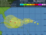
It's a Cat 3:
BULLETIN
HURRICANE IKE SPECIAL ADVISORY NUMBER 11
NWS TPC/NATIONAL HURRICANE CENTER MIAMI FL AL092008
800 PM AST WED SEP 03 2008
...IKE BECOMES THE THIRD MAJOR HURRICANE OF THE SEASON...
AT 800 PM AST...0000Z...THE EYE OF HURRICANE IKE WAS LOCATED NEAR
LATITUDE 21.7 NORTH...LONGITUDE 53.2 WEST OR ABOUT 645 MILES...1035
KM...EAST-NORTHEAST OF THE LEEWARD ISLANDS.
IKE IS MOVING TOWARD THE WEST-NORTHWEST NEAR 18 MPH...30 KM/HR...AND
THIS GENERAL MOTION IS EXPECTED TO CONTINUE TONIGHT AND EARLY
THURSDAY...FOLLOWED BY A TURN TO THE WEST ON THURSDAY NIGHT AND
FRIDAY...TAKING IKE OVER THE OPEN WATERS OF THE WEST-CENTRAL
ATLANTIC DURING THE NEXT COUPLE OF DAYS. IT IS TOO EARLY TO
DETERMINE WHAT IF ANY LAND AREAS MIGHT EVENTUALLY BE AFFECTED BY
IKE.
MAXIMUM SUSTAINED WINDS ARE NEAR 115 MPH...185 KM/HR...WITH HIGHER
GUSTS. IKE IS A DANGEROUS CATEGORY THIRD HURRICANE ON THE
SAFFIR-SIMPSON HURRICANE SCALE. SOME FLUCTUATIONS IN INTENSITY
ARE EXPECTED DURING THE NEXT DAY OR TWO.
HURRICANE FORCE WINDS EXTEND OUTWARD UP TO 35 MILES...55 KM...FROM
THE CENTER...AND TROPICAL STORM FORCE WINDS EXTEND OUTWARD UP TO 160
MILES...260 KM.
THE ESTIMATED MINIMUM CENTRAL PRESSURE IS 960 MB...28.35 INCHES.
REPEATING THE 800 PM AST POSITION...21.7 N...53.2 W. MOVEMENT
TOWARD...WEST-NORTHWEST NEAR 18 MPH. MAXIMUM SUSTAINED WINDS...115
MPH. MINIMUM CENTRAL PRESSURE...960 MB.
THE NEXT ADVISORY WILL BE ISSUED BY THE NATIONAL HURRICANE CENTER AT
1100 PM AST.
$$
FORECASTER BROWN/BLAKE
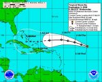
Carp, that one intensified fast from a cat 1 to a cat 3!! 
115 mph winds, and if the NHC's current forecast holds true, it looks as if it could clip South Florida then head into the GOM.
And then there's Hanna, who in true female fashion seems to be taking her good ol' time making up her mind as to what she wants to do.
Heads up gang...
115 mph winds, and if the NHC's current forecast holds true, it looks as if it could clip South Florida then head into the GOM.
And then there's Hanna, who in true female fashion seems to be taking her good ol' time making up her mind as to what she wants to do.
Heads up gang...
Last edited:
Jarhead
Has No Life - Lives on TB
000
WTNT44 KNHC 032346
TCDAT4
HURRICANE IKE SPECIAL DISCUSSION NUMBER 11
NWS TPC/NATIONAL HURRICANE CENTER MIAMI FL AL092008
800 PM EDT WED SEP 03 2008
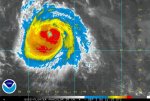
THIS SPECIAL ADVISORY IS TO UPDATE THE INTENSITY OF IKE. SATELLITE
IMAGES INDICATE THAT IKE HAS BEEN RAPIDLY INTENSIFYING AND HAS
DEVELOPED AN EYE THAT IS SURROUNDED BY VERY COLD CLOUD TOPS.
SPECIAL CLASSIFICATION PERFORMED BY TAFB AND SAB BOTH YIELD
T-NUMBERS OF 5.5. IN FACT...THE DATA T-NUMBERS FROM BOTH AGENCIES
WERE SLIGHTLY HIGHER AND RAW ADT ESTIMATES FROM UW-CIMSS HAVE BEEN
RUNNING BETWEEN ABOUT 6.0-6.5 DURING THE LAST 2-3 HOURS. THE
INITIAL INTENSITY IS THEREFORE INCREASED TO 100 KT...MAKING IKE A
CATEGORY THREE HURRICANE. THE INTENSITY FORECAST HAS BEEN RAISED
THROUGHOUT THE PERIOD...BUT AS WITH ALL INTENSE HURRICANES...SOME
FLUCTUATIONS IN INTENSITY SHOULD BE EXPECTED.
NO CHANGES WERE MADE TO THE TRACK FORECAST...AND ONLY MINOR CHANGES
WERE REQUIRED TO THE WIND RADII.
FORECAST POSITIONS AND MAX WINDS
INITIAL 04/0000Z 21.7N 53.2W 100 KT
12HR VT 04/0600Z 22.6N 55.1W 110 KT
24HR VT 04/1800Z 23.8N 57.9W 115 KT
36HR VT 05/0600Z 24.3N 60.4W 115 KT
48HR VT 05/1800Z 23.8N 63.1W 110 KT
72HR VT 06/1800Z 22.5N 68.0W 110 KT
96HR VT 07/1800Z 22.5N 72.0W 115 KT
120HR VT 08/1800Z 23.5N 76.0W 115 KT
$$
FORECASTER BROWN
WTNT44 KNHC 032346
TCDAT4
HURRICANE IKE SPECIAL DISCUSSION NUMBER 11
NWS TPC/NATIONAL HURRICANE CENTER MIAMI FL AL092008
800 PM EDT WED SEP 03 2008
THIS SPECIAL ADVISORY IS TO UPDATE THE INTENSITY OF IKE. SATELLITE
IMAGES INDICATE THAT IKE HAS BEEN RAPIDLY INTENSIFYING AND HAS
DEVELOPED AN EYE THAT IS SURROUNDED BY VERY COLD CLOUD TOPS.
SPECIAL CLASSIFICATION PERFORMED BY TAFB AND SAB BOTH YIELD
T-NUMBERS OF 5.5. IN FACT...THE DATA T-NUMBERS FROM BOTH AGENCIES
WERE SLIGHTLY HIGHER AND RAW ADT ESTIMATES FROM UW-CIMSS HAVE BEEN
RUNNING BETWEEN ABOUT 6.0-6.5 DURING THE LAST 2-3 HOURS. THE
INITIAL INTENSITY IS THEREFORE INCREASED TO 100 KT...MAKING IKE A
CATEGORY THREE HURRICANE. THE INTENSITY FORECAST HAS BEEN RAISED
THROUGHOUT THE PERIOD...BUT AS WITH ALL INTENSE HURRICANES...SOME
FLUCTUATIONS IN INTENSITY SHOULD BE EXPECTED.
NO CHANGES WERE MADE TO THE TRACK FORECAST...AND ONLY MINOR CHANGES
WERE REQUIRED TO THE WIND RADII.
FORECAST POSITIONS AND MAX WINDS
INITIAL 04/0000Z 21.7N 53.2W 100 KT
12HR VT 04/0600Z 22.6N 55.1W 110 KT
24HR VT 04/1800Z 23.8N 57.9W 115 KT
36HR VT 05/0600Z 24.3N 60.4W 115 KT
48HR VT 05/1800Z 23.8N 63.1W 110 KT
72HR VT 06/1800Z 22.5N 68.0W 110 KT
96HR VT 07/1800Z 22.5N 72.0W 115 KT
120HR VT 08/1800Z 23.5N 76.0W 115 KT
$$
FORECASTER BROWN
Attachments
Amanda Blue
Inactive
That looks like one scary storm! I hope it doesn't come my way. I'm definitely leaving town for a while if it does. aacckk!!!!
IM Benedict
Inactive
What, if any, is the probability that Ike will interact with Hanna? Will Ike's outflow grow enough to wrap into that of Hanna?
IM Benedict watching and praying
IM Benedict watching and praying
Amanda Blue
Inactive
I just saw it's up to a category 4 now with winds of 135!
Lilbitsnana
On TB every waking moment
I just saw it's up to a category 4 now with winds of 135!
Yeah, I was trying to catch up with reading on s2k about it being a 2 and the thread header changed! Have to read more and see if it's expected to be a fish, sadly probably not, sigh.
Jarhead
Has No Life - Lives on TB
000
WTNT34 KNHC 040253
TCPAT4
BULLETIN
HURRICANE IKE ADVISORY NUMBER 12
NWS TPC/NATIONAL HURRICANE CENTER MIAMI FL AL092008
1100 PM AST WED SEP 03 2008
...IKE BECOMES AN EXTREMELY DANGEROUS CATEGORY FOUR HURRICANE...
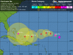
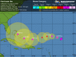
AT 1100 PM AST...0300Z...THE CENTER OF HURRICANE IKE WAS LOCATED
NEAR LATITUDE 22.1 NORTH...LONGITUDE 54.1 WEST OR ABOUT 610 MILES...
980 KM...NORTHEAST OF THE LEEWARD ISLANDS.
IKE IS MOVING TOWARD THE WEST-NORTHWEST NEAR 17 MPH...28 KM/HR...AND
THIS GENERAL MOTION IS EXPECTED TO CONTINUE THROUGH EARLY
THURSDAY...FOLLOWED BY A TURN TO THE WEST ON THURSDAY NIGHT AND
FRIDAY...TAKING IKE OVER THE OPEN WATERS OF THE WEST-CENTRAL
ATLANTIC DURING THE NEXT COUPLE OF DAYS. IT IS TOO EARLY TO
DETERMINE WHAT IF ANY LAND AREAS MIGHT EVENTUALLY BE AFFECTED BY
IKE.
MAXIMUM SUSTAINED WINDS HAVE INCREASED TO NEAR NEAR 135 MPH...215
KM/HR...WITH HIGHER GUSTS. IKE IS AN EXTREMELY DANGEROUS CATEGORY
FOUR HURRICANE ON THE SAFFIR-SIMPSON HURRICANE SCALE. SOME
FLUCTUATIONS IN INTENSITY ARE EXPECTED DURING THE NEXT DAY OR
TWO.
HURRICANE FORCE WINDS EXTEND OUTWARD UP TO 35 MILES...55 KM...FROM
THE CENTER...AND TROPICAL STORM FORCE WINDS EXTEND OUTWARD UP TO 160
MILES...260 KM.
ESTIMATED MINIMUM CENTRAL PRESSURE IS 948 MB...27.99 INCHES.
REPEATING THE 1100 PM AST POSITION...22.1 N...54.1 W. MOVEMENT
TOWARD...WEST-NORTHWEST NEAR 17 MPH. MAXIMUM SUSTAINED WINDS...135
MPH. MINIMUM CENTRAL PRESSURE...948 MB.
THE NEXT ADVISORY WILL BE ISSUED BY THE NATIONAL HURRICANE CENTER AT
500 AM AST.
$$
FORECASTER BROWN
WTNT34 KNHC 040253
TCPAT4
BULLETIN
HURRICANE IKE ADVISORY NUMBER 12
NWS TPC/NATIONAL HURRICANE CENTER MIAMI FL AL092008
1100 PM AST WED SEP 03 2008
...IKE BECOMES AN EXTREMELY DANGEROUS CATEGORY FOUR HURRICANE...
AT 1100 PM AST...0300Z...THE CENTER OF HURRICANE IKE WAS LOCATED
NEAR LATITUDE 22.1 NORTH...LONGITUDE 54.1 WEST OR ABOUT 610 MILES...
980 KM...NORTHEAST OF THE LEEWARD ISLANDS.
IKE IS MOVING TOWARD THE WEST-NORTHWEST NEAR 17 MPH...28 KM/HR...AND
THIS GENERAL MOTION IS EXPECTED TO CONTINUE THROUGH EARLY
THURSDAY...FOLLOWED BY A TURN TO THE WEST ON THURSDAY NIGHT AND
FRIDAY...TAKING IKE OVER THE OPEN WATERS OF THE WEST-CENTRAL
ATLANTIC DURING THE NEXT COUPLE OF DAYS. IT IS TOO EARLY TO
DETERMINE WHAT IF ANY LAND AREAS MIGHT EVENTUALLY BE AFFECTED BY
IKE.
MAXIMUM SUSTAINED WINDS HAVE INCREASED TO NEAR NEAR 135 MPH...215
KM/HR...WITH HIGHER GUSTS. IKE IS AN EXTREMELY DANGEROUS CATEGORY
FOUR HURRICANE ON THE SAFFIR-SIMPSON HURRICANE SCALE. SOME
FLUCTUATIONS IN INTENSITY ARE EXPECTED DURING THE NEXT DAY OR
TWO.
HURRICANE FORCE WINDS EXTEND OUTWARD UP TO 35 MILES...55 KM...FROM
THE CENTER...AND TROPICAL STORM FORCE WINDS EXTEND OUTWARD UP TO 160
MILES...260 KM.
ESTIMATED MINIMUM CENTRAL PRESSURE IS 948 MB...27.99 INCHES.
REPEATING THE 1100 PM AST POSITION...22.1 N...54.1 W. MOVEMENT
TOWARD...WEST-NORTHWEST NEAR 17 MPH. MAXIMUM SUSTAINED WINDS...135
MPH. MINIMUM CENTRAL PRESSURE...948 MB.
THE NEXT ADVISORY WILL BE ISSUED BY THE NATIONAL HURRICANE CENTER AT
500 AM AST.
$$
FORECASTER BROWN
Jarhead
Has No Life - Lives on TB
000
WTNT44 KNHC 040257
TCDAT4
HURRICANE IKE DISCUSSION NUMBER 12
NWS TPC/NATIONAL HURRICANE CENTER MIAMI FL AL092008
1100 PM EDT WED SEP 03 2008
IKE HAS RAPIDLY INTENSIFIED THIS EVENING. AN EYE BECAME APPARENT IN
CONVENTIONAL SATELLITE IMAGERY SHORTLY AFTER 2100 UTC. SINCE THAT
TIME THE EYE HAS BECOME MORE DISTINCT WITH A RING OF VERY COLD
CLOUDS TOPS SURROUNDING IT. THE LATEST DVORAK DATA T-NUMBERS WERE
T6.0 AND RAW ADT ESTIMATES FROM UW-CIMSS HAVE AVERAGED T6.2 SINCE
2045 UTC. BASED ON THESE ESTIMATES THE INITIAL INTENSITY IS SET
AT 115 KT...MAKING IKE A CATEGORY FOUR HURRICANE. SOME ADDITIONAL
STRENGTHENING IS POSSIBLE DURING THE NEXT 12 HOURS OR SO...THIS
WILL LARGELY BE CONTROLLED BY EYE-WALL REPLACEMENT CYCLES. HOWEVER
BOTH THE GLOBAL MODELS AND SHIPS GUIDANCE INDICATE INCREASING
NORTHEASTERLY SHEAR IN ABOUT 24 HOURS AND IT IS DIFFICULT TO
PREDICT HOW AN INTENSE HURRICANE LIKE IKE WILL BE AFFECTED BY THIS
SHEAR. THE NHC INTENSITY FORECAST INDICATES SOME WEAKENING BETWEEN
24-72 HOURS DUE TO THE SHEAR...BUT NOT AS MUCH AS INDICATED BY THE
SHIPS GUIDANCE. AT DAYS 4 AND 5...IT APPEARS THAT THE SHEAR WILL
DECREASE SO RE-STRENGTHENING IS PREDICTED AT THAT TIME.
THE INITIAL MOTION ESTIMATE IS 295/15. THE TRACK GUIDANCE AGREES
ON A CONTINUED WEST-NORTHWESTWARD MOTION DURING THE NEXT 24 HOURS.
DURING THE MIDDLE PORTION OF THE FORECAST PERIOD...A MID-LEVEL
RIDGE IS EXPECTED TO BUILD TO THE NORTH OF THE CYCLONE...AND THE
MODELS UNANIMOUSLY RESPOND BY TURNING IKE WEST-SOUTHWESTWARD. THE
LINGERING QUESTION THAT REMAINS AT THE LONGER RANGE IS WHEN IKE
WILL MOVE AROUND THE WESTERN PERIPHERY OF THE RIDGE. THE
MODEL SPREAD REMAINS QUITE LARGE AT DAYS 4 AND 5. THE GFDL IS ON
THE LEFT SIDE OF THE GUIDANCE WITH A TRACK NEAR HISPANIOLA AND
EASTERN CUBA...WHILE THE GFS AND UKMET SHOW A POSITION TO THE
NORTHEAST OF THE BAHAMAS. FOR NOW...THE OFFICIAL TRACK IS BETWEEN
THESE POSSIBLE SOLUTIONS AND IS IN BEST AGREEMENT WITH THE
HWRF...THE 12Z ECMWF...AND THE MODEL CONSENSUS.
FORECAST POSITIONS AND MAX WINDS
INITIAL 04/0300Z 22.1N 54.1W 115 KT
12HR VT 04/1200Z 23.1N 56.2W 115 KT
24HR VT 05/0000Z 24.0N 58.7W 105 KT
36HR VT 05/1200Z 24.3N 61.0W 105 KT
48HR VT 06/0000Z 23.8N 63.6W 100 KT
72HR VT 07/0000Z 22.5N 68.5W 100 KT
96HR VT 08/0000Z 22.5N 72.0W 110 KT
120HR VT 09/0000Z 24.0N 75.5W 115 KT
$$
FORECASTER BROWN
Attachments

IM Benedict
Inactive
Jarhead
Has No Life - Lives on TB
000
WTNT34 KNHC 040837
TCPAT4
BULLETIN
HURRICANE IKE ADVISORY NUMBER 13
NWS TPC/NATIONAL HURRICANE CENTER MIAMI FL AL092008
500 AM AST THU SEP 04 2008
...IKE EVEN STRONGER AS IT CONTINUES WEST-NORTHWESTWARD...
AT 500 AM AST...0900Z...THE CENTER OF HURRICANE IKE WAS LOCATED NEAR
LATITUDE 22.7 NORTH...LONGITUDE 55.8 WEST OR ABOUT 550 MILES...885
KM...NORTHEAST OF THE LEEWARD ISLANDS.
IKE IS MOVING TOWARD THE WEST-NORTHWEST NEAR 17 MPH...28 KM/HR...AND
A GRADUAL TURN TOWARD THE WEST AND WEST-SOUTHWEST IS EXPECTED OVER
THE NEXT 48 HOURS. ON THIS TRACK THE HURRICANE WILL CONTINUE TO
MOVE OVER THE OPEN WATERS OF THE WEST-CENTRAL ATLANTIC DURING THE
NEXT COUPLE OF DAYS. IT IS TOO EARLY TO DETERMINE WHAT LAND AREAS
MIGHT EVENTUALLY BE AFFECTED BY IKE.
SATELLITE IMAGES INDICATE THAT IKE HAS INTENSIFIED SOME MORE.
MAXIMUM SUSTAINED WINDS ARE ESTIMATED TO BE NEAR 145 MPH...230
KM/HR...WITH HIGHER GUSTS. THIS IS AN EXTREMELY DANGEROUS CATEGORY
FOUR HURRICANE ON THE SAFFIR-SIMPSON HURRICANE SCALE. IT IS
EXPECTED THAT IKE WILL MAINTAIN CATEGORY FOUR OR CATEGORY THREE
INTENSITY OVER THE NEXT 48 HOURS.
HURRICANE FORCE WINDS EXTEND OUTWARD UP TO 35 MILES...55 KM...FROM
THE CENTER...AND TROPICAL STORM FORCE WINDS EXTEND OUTWARD UP TO 140
MILES...220 KM.
ESTIMATED MINIMUM CENTRAL PRESSURE IS 935 MB...27.61 INCHES.
REPEATING THE 500 AM AST POSITION...22.7 N...55.8 W. MOVEMENT
TOWARD...WEST-NORTHWEST NEAR 17 MPH. MAXIMUM SUSTAINED WINDS...145
MPH. MINIMUM CENTRAL PRESSURE...935 MB.
THE NEXT ADVISORY WILL BE ISSUED BY THE NATIONAL HURRICANE CENTER AT
1100 AM AST.
$$
FORECASTER PASCH
Jarhead
Has No Life - Lives on TB
000
WTNT44 KNHC 040838
TCDAT4
HURRICANE IKE DISCUSSION NUMBER 13
NWS TPC/NATIONAL HURRICANE CENTER MIAMI FL AL092008
500 AM EDT THU SEP 04 2008
SATELLITE IMAGES INDICATE THAT IKE HAS INTENSIFIED FURTHER...WITH
THE EYE EMBEDDED IN EVEN COLDER CLOUD TOPS THAN BEFORE. THE LATEST
DVORAK DATA T-NUMBERS ARE UP TO 6.5 WHICH SUPPORTS AN INTENSITY OF
125 KT...AND THIS IS USED FOR THE CURRENT ADVISORY. IN SUCH
INTENSE HURRICANES...FLUCTUATIONS IN STRENGTH DUE TO INNER-CORE
EVOLUTIONS SUCH AS EYEWALL REPLACEMENTS ARE NEARLY IMPOSSIBLE TO
PREDICT. HOWEVER...THE SHIPS MODEL SHOWS OVER 30 KT OF VERTICAL
SHEAR ON IKE WITHIN THE NEXT 24-36 HOURS DUE TO A STRENGTHENING
UPPER-LEVEL HIGH TO THE NORTHWEST OF THE HURRICANE. THIS
LARGE-SCALE ENVIRONMENTAL INFLUENCE SHOULD INDUCE SOME WEAKENING...
AND THAT IS WHAT IS INDICATED IN THE OFFICIAL WIND SPEED FORECAST.
LATER ON IN THE FORECAST PERIOD...SOME RE-STRENGTHENING IS PROBABLE
AS THE SHEAR WEAKENS AND THE THERMODYNAMIC ENVIRONMENT IS EXPECTED
TO BE FAVORABLE. THE OFFICIAL FORECAST MIGHT BE CONSERVATIVE BUT
IT REFLECTS OUR LACK OF SKILL IN FORECASTING TROPICAL CYCLONE
INTENSITY IN 3-5 DAYS.
IKE CONTINUES TO MOVE WEST-NORTHWESTWARD OR AROUND 290/15. THERE
HAS BEEN LITTLE CHANGE TO THE TRACK FORECAST OR FORECAST REASONING.
A DEEP-LAYER HIGH IS DEPICTED BY THE GLOBAL MODELS TO BUILD TO THE
NORTHWEST OF THE HURRICANE WITHIN THE NEXT COUPLE OF DAYS. THIS
WOULD LIKELY CAUSE THE HEADING OF IKE TO BEND WESTWARD TO
WEST-SOUTHWESTWARD. LATE IN THE FORECAST PERIOD IT IS EXPECTED
THAT IKE WILL HAVE PASSED THE CENTER OF THE HIGH...AND TURN BACK
TOWARD THE WEST AND WEST-NORTHWEST. THE BIG QUESTIONS IS HOW THE
HURRICANE RESPONDS TO THE WEAKNESS IN THE MID-TROPOSPHERIC RIDGE
OVER THE SOUTHEASTERN U.S. AROUND DAY 5. LOOKING AT THE VARIOUS
TRACK MODELS IN THIS TIME FRAME...WE SEE THAT THE ECMWF IS THE
WESTERNMOST AND THE GFS IS THE NORTHEASTERNMOST. THE OFFICIAL
TRACK FORECAST LIES BETWEEN THESE EXTREMES AND LEANS TOWARD THE
ECMWF. THIS IS A LITTLE TO THE LEFT OF THE DYNAMICAL MODEL
CONSENSUS AND QUITE SIMILAR TO THE PREVIOUS NHC FORECAST.
BECAUSE OF THE UNCERTAINTIES IN 4- AND 5-DAY TRACK FORECASTS...IT IS
STILL TOO EARLY TO SAY WHAT LAND AREAS ARE LIKELY TO BE IMPACTED BY
THIS HURRICANE.
FORECAST POSITIONS AND MAX WINDS
INITIAL 04/0900Z 22.7N 55.8W 125 KT
12HR VT 04/1800Z 23.5N 57.7W 125 KT
24HR VT 05/0600Z 24.0N 60.2W 115 KT
36HR VT 05/1800Z 24.0N 62.6W 110 KT
48HR VT 06/0600Z 23.4N 64.9W 110 KT
72HR VT 07/0600Z 22.5N 69.5W 115 KT
96HR VT 08/0600Z 23.0N 73.5W 115 KT
120HR VT 09/0600Z 25.0N 76.5W 115 KT
$$
FORECASTER PASCH
Attachments

- Status
- Not open for further replies.