FlyLadyFan
Inactive
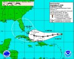
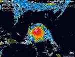
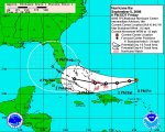
Wonder if Ike will cross over the peninsula and carry on in the Gulf.
Thanks again, Jarhead.
FLF
.
Thanks again, Jarhead.
FLF
.

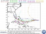
This one I may just board up the house and get out of the way for awhile.
The problem is if I head north I just don't want this storm following me up the turnpike. I'll wait till Saturday or Sunday to get a better handle on it, before I decide on what I'll do.

I think, well at least I hope that was a joke Jar. Can't get much more "real time" than this...What "Live Feed" are you referring to?


Wonder if Ike will cross over the peninsula and carry on in the Gulf.
Thanks again, Jarhead.
FLF
.

HUSH, FLF!
Don't even THINK to suggest another gulf storm!
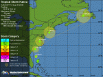
Folks, looking at tropical storm Hannah's track up the east coast, I am wondering how this will affect southern Florida's evacuation possibilities if needed from Ike?
This is starting to look like a really bad situation.
garnetgirl


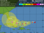
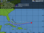
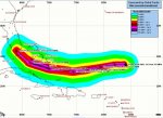
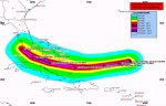
There are flights planned today to look at Ike and perhaps get a better feel for where it might go.
Check the following for active tropical storms, including the latest on Ike and Hanna:
http://www.storm2k.org/phpbb2/viewforum.php?f=59&sid=0311e156c93792622468c7792f46cc63
I think, well at least I hope that was a joke Jar. Can't get much more "real time" than this...
Keep up the great job!
Let us know if you need some relief. We'll get somebody like Kickapoo in here to sub for a while...
Where is Kick anyway???
Told ya I jinxed us all here on the Gulf by getting that new metal roof put on. It's all my fault. This one I'm worried about. This one told me he is coming to Bama. LOL
Looks like I'll be running up to West Blockton after all. At least I can fish for a day or two up there before it starts raining.