
You are using an out of date browser. It may not display this or other websites correctly.
You should upgrade or use an alternative browser.
You should upgrade or use an alternative browser.
- Status
- Not open for further replies.
Jarhead
Has No Life - Lives on TB
Ike grows in size and strength
Posted by: JeffMasters, on September 10, 2008
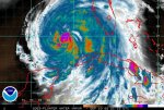
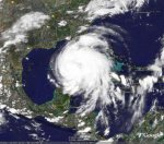
Hurricane Ike has grown into a very large and powerful Category 2 hurricane. At 2 pm EDT, the Hurricane Hunters found maximum winds had increased to 100 mph.
This increase in winds was a reaction to the 10 mb drop in pressure noted in the past 12 hours. The most recent pressure measured--958 mb at 3:09 pm EDT--was actually a 1 mb increase from the 10 am reading, indicating that Ike's intensity has likely leveled off for now.
Visible satellite loops show that Ike has ingested some dry air from the west, which is visible as a spiral dark streak that wraps into the core of the storm. The small 11-mile diameter eye occasionally pops into view, and is exhibiting the unusual behavior of orbiting around in a large circle within the hurricane. Hurricane Wilma of 2005--the strongest hurricane on record--exhibited this behavior during its intensification phase, as well. However, Wilma was not sucking in dry air at the time, and Ike is not likely to approach Wilma's ferocity.
A large spiral band surrounding Ike's inner eye is attempting to close off and form a new outer eyewall with a diameter of 100 miles. The power struggle between the small inner eyewall and the large outer spiral band will likely go on until Thursday, resulting in little intensification of Ike this evening. By Thursday, the power struggle will likely be over, and Ike will probably resume intensification. If the small eyewall wins, Ike could intensify rapidly to a Category 4 hurricane; if the large spiral band takes over as the new eyewall and the inner eyewall crumbles, we can expect more gradual intensification to a Category 3 hurricane.
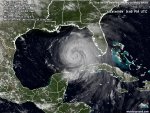
Ike continues to grow in size, and its tropical storm force winds extend out almost as far as Katrina's did. This large wind field is already starting to pile up a formidable storm surge. Tides are already running 2-4 feet above normal along the Gulf Coast from Louisiana to the west coast of Florida.
Visible satellite loops show that Ike has good upper-level outflow channels open to the north and the south. Outflow and cloud cover are restricted on the storm's west side, where dry air and wind shear of 10-15 knots are affecting the storm.
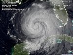
All indications are that Ike will intensify into a major hurricane that will bring widespread destruction to a large stretch of the Texas coast. I expect Ike will generate a 10-15 foot storm surge along a 100-mile stretch of Texas coast from the eye landfall location, northwards.
I urge Texas residents to take this storm very seriously and heed any evacuation orders given. Most of you living along the coast have never experienced a major hurricane, and Ike is capable of causing high loss of life in storm surge-prone areas.
Tropical storm force winds will spread over the Texas coast beginning Friday afternoon, and evacuations must be completed by Friday morning. All airports in eastern Texas will be forced to close Friday night, and will probably remain closed most of Saturday. Ike has a good chance of becoming the most destructive hurricane in Texas history--though not the most powerful.
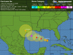
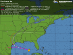
Track forecast for Ike
The latest 12Z (8am EDT)) computer models are in even less agreement than the previous set of runs.
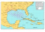
There has been a northward shift in several models, most notably the GFDL, which now has Ike making landfall at Galveston as a strong Category 3 hurricane. With a trough of low pressure expected to turn Ike northwestward close to landfall time, slight variations in the timing of this trough among the models is causing a large spread in landfall locations.
Given the recent trend in the models to take Ike farther north, I would expect more of the models in future runs may be joining the GFDL in predicting a Galveston landfall. The cone of uncertainty still covers the entire Texas coast, and residents of southwestern Louisiana are also at risk.
I recommend Texas residents consult NHC's wind probability product to determine their odds of getting hurricane force winds. At 11 am EDT, NHC called for these odds of getting hurricane force winds at various Texas cities:
Brownsville: 9%
Corpus Christi: 17%
Port O'Connor: 24%
Freeport: 23%
Galveston: 20%
Houston: 13%
As you can see, Port O'Connor is considered the most likely city in Texas to receive hurricane force winds. I believe the percentages for the cities above except Brownsville and Corpus Christi are too low, and should be bumped up by 5-10%.
Intensity forecast for Ike
The intensity forecast remains the same. Water temperatures are a warm 29.5°C in the Gulf of Mexico, and wind shear is expected to be modest, 10-15 knots, for the remainder of Ike's life. Ike will be crossing over two regions of high heat content associated with the Loop Current and a Loop Current eddy, and Ike has the capability of intensifying right up to landfall. This is the forecast of the HWRF model, which has Ike hitting Port O'Connor as a Category 4 hurricane with 145 mph winds. The weakest I think Ike will be at landfall is Category 2 hurricane with 100 mph winds.
Storm surge risk
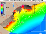
We've put together today a page of storm surge risks for the Texas coast. These images show the maximum storm tide (storm surge plus an adjustment for hitting at high tide) expected from a mid-strength hurricane of each Saffir-Simpson Category hitting anywhere along the coast of Texas at high tide. These so-called "MOMs" (Maximum Of the Maximum Envelope Of Waters) are computed using NOAA's SLOSH storm surge model. A sample image is shown in Figure 1 for a Category 4 hurricane affecting the Galveston area. A storm of this magnitude is expected to bring a maximum 22 foot storm tide (storm surge plus a 2-foot adjustment in case it hits at high tide) to Galveston.
A maximum 28-foot storm tide could affect the built-up areas along the east side of Houston. Note that most Category 4 hurricanes making a direct hit on Galveston will bring a significantly lower storm surge than the worst-case 22-foot scenario pictured here.
For example, the Great Galveston Hurricane of 1900 was a Category 4 storm that hit the city head-on, but generated a storm surge of only 15 feet. Even so, this hurricane was the deadliest disaster in American history, killing an estimated 8,000-12,000 people. Since then, Galveston has built its seawall to a height of 17 feet, which would probably withstand a direct hit by Ike at Category 4 strength.
For storm surge evacuation zone information, consult the Texas Division of Emergency Management.
Ike is a large storm, and will probably attain Category 3 or higher status over the Gulf of Mexico. This will set in motion a huge volume of water that will pile up into a large storm surge once Ike reaches the shallow Continental Shelf waters off the coast of Texas. Even if Ike weakens significantly before landfall, I am still expecting the storm to bring a storm surge 10-15 feet to a 100 mile long stretch of Texas coast from the eye northwards along the Texas coast. High tide on Saturday morning along the Texas coast is at 2am CDT. The range between low tide and high tide along the Texas coast is about 2 feet.
Jeff Masters
Figure 1. The maximum storm tide (storm surge plus an adjustment for hitting at high tide) expected from a mid-strength (145 mph) Category 4 hurricane hitting anywhere along the coast of Texas at high tide. This so-called "MOM" (Maximum Of the Maximum Envelope Of Waters) is computed using NOAA's SLOSH storm surge model. The plot above IS NOT the expected storm tide everywhere along the coast from a hit by Hurricane Ike. The plot is the MAXIMUM high water for a worst-case scenario Category 4 hurricane moving at the worst possible angle at the worst possible forward speed. As such, this plot is the combination of SLOSH runs from over 50 different simulated hurricanes approaching the coast at different angles and different forward speeds. The maximums plotted here are only possible along a 20-mile stretch of the coast on the north side of Ike's eyewall. SLOSH model runs are advertised as being in error by plus or minus 20%. Image credit: NOAA.
Posted by: JeffMasters, on September 10, 2008
Hurricane Ike has grown into a very large and powerful Category 2 hurricane. At 2 pm EDT, the Hurricane Hunters found maximum winds had increased to 100 mph.
This increase in winds was a reaction to the 10 mb drop in pressure noted in the past 12 hours. The most recent pressure measured--958 mb at 3:09 pm EDT--was actually a 1 mb increase from the 10 am reading, indicating that Ike's intensity has likely leveled off for now.
Visible satellite loops show that Ike has ingested some dry air from the west, which is visible as a spiral dark streak that wraps into the core of the storm. The small 11-mile diameter eye occasionally pops into view, and is exhibiting the unusual behavior of orbiting around in a large circle within the hurricane. Hurricane Wilma of 2005--the strongest hurricane on record--exhibited this behavior during its intensification phase, as well. However, Wilma was not sucking in dry air at the time, and Ike is not likely to approach Wilma's ferocity.
A large spiral band surrounding Ike's inner eye is attempting to close off and form a new outer eyewall with a diameter of 100 miles. The power struggle between the small inner eyewall and the large outer spiral band will likely go on until Thursday, resulting in little intensification of Ike this evening. By Thursday, the power struggle will likely be over, and Ike will probably resume intensification. If the small eyewall wins, Ike could intensify rapidly to a Category 4 hurricane; if the large spiral band takes over as the new eyewall and the inner eyewall crumbles, we can expect more gradual intensification to a Category 3 hurricane.
Ike continues to grow in size, and its tropical storm force winds extend out almost as far as Katrina's did. This large wind field is already starting to pile up a formidable storm surge. Tides are already running 2-4 feet above normal along the Gulf Coast from Louisiana to the west coast of Florida.
Visible satellite loops show that Ike has good upper-level outflow channels open to the north and the south. Outflow and cloud cover are restricted on the storm's west side, where dry air and wind shear of 10-15 knots are affecting the storm.
All indications are that Ike will intensify into a major hurricane that will bring widespread destruction to a large stretch of the Texas coast. I expect Ike will generate a 10-15 foot storm surge along a 100-mile stretch of Texas coast from the eye landfall location, northwards.
I urge Texas residents to take this storm very seriously and heed any evacuation orders given. Most of you living along the coast have never experienced a major hurricane, and Ike is capable of causing high loss of life in storm surge-prone areas.
Tropical storm force winds will spread over the Texas coast beginning Friday afternoon, and evacuations must be completed by Friday morning. All airports in eastern Texas will be forced to close Friday night, and will probably remain closed most of Saturday. Ike has a good chance of becoming the most destructive hurricane in Texas history--though not the most powerful.
Track forecast for Ike
The latest 12Z (8am EDT)) computer models are in even less agreement than the previous set of runs.
There has been a northward shift in several models, most notably the GFDL, which now has Ike making landfall at Galveston as a strong Category 3 hurricane. With a trough of low pressure expected to turn Ike northwestward close to landfall time, slight variations in the timing of this trough among the models is causing a large spread in landfall locations.
Given the recent trend in the models to take Ike farther north, I would expect more of the models in future runs may be joining the GFDL in predicting a Galveston landfall. The cone of uncertainty still covers the entire Texas coast, and residents of southwestern Louisiana are also at risk.
I recommend Texas residents consult NHC's wind probability product to determine their odds of getting hurricane force winds. At 11 am EDT, NHC called for these odds of getting hurricane force winds at various Texas cities:
Brownsville: 9%
Corpus Christi: 17%
Port O'Connor: 24%
Freeport: 23%
Galveston: 20%
Houston: 13%
As you can see, Port O'Connor is considered the most likely city in Texas to receive hurricane force winds. I believe the percentages for the cities above except Brownsville and Corpus Christi are too low, and should be bumped up by 5-10%.
Intensity forecast for Ike
The intensity forecast remains the same. Water temperatures are a warm 29.5°C in the Gulf of Mexico, and wind shear is expected to be modest, 10-15 knots, for the remainder of Ike's life. Ike will be crossing over two regions of high heat content associated with the Loop Current and a Loop Current eddy, and Ike has the capability of intensifying right up to landfall. This is the forecast of the HWRF model, which has Ike hitting Port O'Connor as a Category 4 hurricane with 145 mph winds. The weakest I think Ike will be at landfall is Category 2 hurricane with 100 mph winds.
Storm surge risk
We've put together today a page of storm surge risks for the Texas coast. These images show the maximum storm tide (storm surge plus an adjustment for hitting at high tide) expected from a mid-strength hurricane of each Saffir-Simpson Category hitting anywhere along the coast of Texas at high tide. These so-called "MOMs" (Maximum Of the Maximum Envelope Of Waters) are computed using NOAA's SLOSH storm surge model. A sample image is shown in Figure 1 for a Category 4 hurricane affecting the Galveston area. A storm of this magnitude is expected to bring a maximum 22 foot storm tide (storm surge plus a 2-foot adjustment in case it hits at high tide) to Galveston.
A maximum 28-foot storm tide could affect the built-up areas along the east side of Houston. Note that most Category 4 hurricanes making a direct hit on Galveston will bring a significantly lower storm surge than the worst-case 22-foot scenario pictured here.
For example, the Great Galveston Hurricane of 1900 was a Category 4 storm that hit the city head-on, but generated a storm surge of only 15 feet. Even so, this hurricane was the deadliest disaster in American history, killing an estimated 8,000-12,000 people. Since then, Galveston has built its seawall to a height of 17 feet, which would probably withstand a direct hit by Ike at Category 4 strength.
For storm surge evacuation zone information, consult the Texas Division of Emergency Management.
Ike is a large storm, and will probably attain Category 3 or higher status over the Gulf of Mexico. This will set in motion a huge volume of water that will pile up into a large storm surge once Ike reaches the shallow Continental Shelf waters off the coast of Texas. Even if Ike weakens significantly before landfall, I am still expecting the storm to bring a storm surge 10-15 feet to a 100 mile long stretch of Texas coast from the eye northwards along the Texas coast. High tide on Saturday morning along the Texas coast is at 2am CDT. The range between low tide and high tide along the Texas coast is about 2 feet.
Jeff Masters
Figure 1. The maximum storm tide (storm surge plus an adjustment for hitting at high tide) expected from a mid-strength (145 mph) Category 4 hurricane hitting anywhere along the coast of Texas at high tide. This so-called "MOM" (Maximum Of the Maximum Envelope Of Waters) is computed using NOAA's SLOSH storm surge model. The plot above IS NOT the expected storm tide everywhere along the coast from a hit by Hurricane Ike. The plot is the MAXIMUM high water for a worst-case scenario Category 4 hurricane moving at the worst possible angle at the worst possible forward speed. As such, this plot is the combination of SLOSH runs from over 50 different simulated hurricanes approaching the coast at different angles and different forward speeds. The maximums plotted here are only possible along a 20-mile stretch of the coast on the north side of Ike's eyewall. SLOSH model runs are advertised as being in error by plus or minus 20%. Image credit: NOAA.
Attachments

lafrteacher
Inactive
I think it will hit western LA. My kids are calling it "Hurricane Icky" 
The weather forecasters were very sure about Gustav's forecast, and it was accurate. They are guessing on this one. If Ike stays slow (right now moving NW at 8 mph), it will hit LA. If it speeds up, it will hit TX.
The weather forecasters were very sure about Gustav's forecast, and it was accurate. They are guessing on this one. If Ike stays slow (right now moving NW at 8 mph), it will hit LA. If it speeds up, it will hit TX.
Last edited:
Jarhead
Has No Life - Lives on TB
I think it will hit western LA. My kids are calling it "Hurricane Icky"
The weather forecasters were very sure about Gustav's forecast, and it was accurate. They are guessing on this one. If Ike stays slow (right now moving NW at 8 mph), it will hit LA. If it speeds up, it will hit TX.
That's the way I'm seeing it too. They know Ike will turn to the NNW/N, the question is "How Soon".
Jarhead

PS... You're very welcome, mole..
lafrteacher
Inactive
That's the way I'm seeing it too. They know Ike will turn to the NNW/N, the question is "How Soon".
Jarhead
The nightmare scenario is Ike hitting New Orleans. They wouldn't even have 24 hours to evacuate.
Jarhead
Has No Life - Lives on TB
The nightmare scenario is Ike hitting New Orleans. They wouldn't even have 24 hours to evacuate.
The sad part is that many would not evac. this time.

Jarhead
Jarhead
Has No Life - Lives on TB
Ike forecast to be Category 4 hurricane at landfall
(CNN) -- Mandatory evacuations were ordered in some Texas Gulf Coast counties Wednesday ahead of Hurricane Ike, which is expected to hit the coast Saturday.
The storm could swell to a dangerous Category 4 but is currently a Category 2 hurricane, forecasters said.
As of 5 p.m. ET, Ike had top sustained winds near 100 mph and was about 720 miles (1,155 km) east of Brownsville, Texas, and about 370 miles (590 km) south-southeast of the mouth of the Mississippi River, the hurricane center said.
Hurricane-force winds extended out up to 90 miles (50 km) from the storm's center, and tropical storm-force winds extended out up to 205 miles (335 km), forecasters reported.
About 15,000 residents were leaving Galveston's Brazoria County Wednesday after a mandatory evacuation order was issued at 10 a.m. CT (11 a.m. ET) governing one ZIP code -- 77541 -- and residents throughout the county with special needs.
Galveston City Manager Steve LeBlanc issued a warning to residents of the city's West End, citing forecasters' estimates that the area could get tides of 6 feet above normal if the storm arrives there. The West End is the area of Galveston most susceptible to flooding, LeBlanc said. iReport.com: Are you getting ready for Ike? Share photos, video
Other Brazoria residents were being allowed to remain as of 6 p.m. ET. Officials are expected to provide another update later Wednesday.
In Matagorda County, southwest of Galveston, officials ordered a mandatory evacuation for all areas except the cities of Bay City and Van Vleck.
The evacuation must be completed by at 6 p.m. (7 p.m. ET) Thursday. Galveston is likely to experience a high tidal surge, officials said, urging people living in low-lying areas or mobile homes to get out soon.
"One of the things that the public has to understand if they decide to stay, there will be a period of time during this storm when they will absolutely be on their own," Brazoria County Sheriff Charles Wagner said.
"There will be no medical services; there will be no fire department; there will be no law enforcement, groceries, gasoline, drugs, electricity."
The center issued a tropical storm warning from the Mississippi River's mouth to Cameron, Louisiana, and a hurricane watch from Cameron to Port Mansfield, Texas, about 60 miles south of Brownsville. Tropical storm warnings mean winds of 39 to 73 mph (63 to 118 kmh) are expected within a day, and a hurricane watch means winds of 74 and higher are expected within 36 hours.
"Hurricane Ike is now in the Gulf of Mexico and making its approach toward our coast," Gov. Rick Perry said in a statement. "The next few days will be crucial for residents to follow the direction of local leaders and to take the necessary steps to protect themselves and their families."
Perry put 7,500 National Guard members on standby this week, his office said, and issued a disaster declaration for 88 counties.
"If anything, this 2008 hurricane season has demonstrated that we have to be prepared at all times. Hurricanes do not occur at convenient times or with sufficiently timed intervals," he said.
About 1,350 buses, several ambulances and paramedic buses were available to support evacuations. The vehicles were positioned near Houston, Matagorda County, Nueces County and Victoria County, the governor's office said.
President Bush declared an emergency in the state, making federal funds available for the state to prepare for the storm.
Corpus Christi officials also began the evacuation process for residents with special needs, supplying buses to transport them out of town.
Perhaps more important to many in Texas, dozens of high school football games in cities and towns along the coast were rescheduled from Friday to Thursday night to avoid playing in the storm, CNN affiliate KGBT-TV reported.
The National Hurricane Center indicated that Ike would probably come ashore Saturday along the Texas coast between Galveston and Brownsville as a major hurricane with winds up to 130 mph. But forecasters stressed the unpredictability of the storm, which could change course at the last minute.
"It's very frustrating for all of us," Galveston Mayor Lyda Ann Thomas said. "We're on alert, and we will continue to monitor this storm. I wish we could be clearer about where it's going."
Thomas warned residents to stock up on nonperishable items, including pet food and diapers, and to prepare for going without electricity.
http://www.cnn.com/2008/US/weather/09/10/hurricane.ike/index.html
night driver
ESFP adrift in INTJ sea
He is down to 947 mb as of late this evening....
And he's got the whole dang Gulf to cross.....
Houston, Galveston, SA, DALLAS even best prep up.
And he's got the whole dang Gulf to cross.....
Houston, Galveston, SA, DALLAS even best prep up.
I've had really bad feelings about this one for a couple days now. And it's *Galveston* which keeps coming to mind. Probably read one too many stories about the bad 'cane which hit there, in what? Late 1800's? This storm has me a bit spooked, and it's the only one (so far) this year which had me feeling this way.
Stay SAFE, guys. If you're anywhere in the potential track of this one, be ready to get OUT!
Summerthyme
Stay SAFE, guys. If you're anywhere in the potential track of this one, be ready to get OUT!
Summerthyme
I've had really bad feelings about this one for a couple days now. And it's *Galveston* which keeps coming to mind.
Summerthyme
Watch your mouth, girl...

Yeah, this one has a bunch of us glued tv on the right, TB/Jarhead in front, and a radio earphone in the left ear....
Truck & auto are ready for BO for the wife & kids/grands, if Ike moves much more north, tomorrow early pm is go.
Jarhead
Has No Life - Lives on TB
000
WTNT34 KNHC 102349
TCPAT4
BULLETIN
HURRICANE IKE INTERMEDIATE ADVISORY NUMBER 39A
NWS TPC/NATIONAL HURRICANE CENTER MIAMI FL AL092008
700 PM CDT WED SEP 10 2008
...IKE CONTINUES NORTHWESTWARD TOWARD THE CENTRAL GULF...
A TROPICAL STORM WARNING REMAINS IN EFFECT FROM THE MOUTH OF THE
MISSISSIPPI RIVER WESTWARD TO EAST OF CAMERON LOUISIANA. A
TROPICAL STORM WARNING MEANS THAT TROPICAL STORM CONDITIONS ARE
EXPECTED WITHIN THE WARNING AREA WITHIN THE NEXT 24 HOURS. A
TROPICAL STORM WARNING ALSO REMAINS IN EFFECT FROM WEST OF KEY WEST
TO THE DRY TORTUGAS.
A HURRICANE WATCH REMAINS IN EFFECT FROM CAMERON WESTWARD TO PORT
MANSFIELD TEXAS. HURRICANE CONDITIONS ARE POSSIBLE WITHIN THE
WATCH AREA BY FRIDAY.
FOR STORM INFORMATION SPECIFIC TO YOUR AREA...INCLUDING POSSIBLE
INLAND WATCHES AND WARNINGS...PLEASE MONITOR PRODUCTS ISSUED
BY YOUR LOCAL WEATHER OFFICE.
AT 700 PM CDT...0000Z...THE CENTER OF HURRICANE IKE WAS LOCATED NEAR
LATITUDE 24.7 NORTH...LONGITUDE 86.3 WEST OR ABOUT 700 MILES...1125
KM...EAST OF BROWNSVILLE TEXAS AND ABOUT 345 MILES...555 KM...
SOUTH-SOUTHEAST OF THE MOUTH OF THE MISSISSIPPI RIVER.
IKE IS MOVING TOWARD THE NORTHWEST NEAR 8 MPH...13 KM/HR. A TURN
BACK TOWARD THE WEST-NORTHWESTWARD IS EXPECTED TONIGHT OR EARLY ON
THURSDAY...AND A GENERAL WEST-NORTHWESTWARD MOTION OVER THE CENTRAL
AND WESTERN GULF OF MEXICO IS EXPECTED ON THURSDAY AND FRIDAY.
MAXIMUM SUSTAINED WINDS ARE NEAR 100 MPH...160 KM/HR...WITH HIGHER
GUSTS. IKE IS A CATEGORY TWO HURRICANE ON THE SAFFIR-SIMPSON
HURRICANE SCALE. IKE IS EXPECTED TO BECOME A MAJOR HURRICANE BY
THURSDAY.
IKE IS A LARGE TROPICAL CYCLONE. HURRICANE FORCE WINDS EXTEND
OUTWARD UP TO 115 MILES...185 KM...FROM THE CENTER...AND TROPICAL
STORM FORCE WINDS EXTEND OUTWARD UP TO 205 MILES...335 KM.
THE LATEST MINIMUM CENTRAL PRESSURE REPORTED BY AN AIR FORCE
RECONNAISSANCE AIRCRAFT WAS 947 MB...27.96 INCHES.
COASTAL STORM SURGE FLOODING ALONG THE COASTS OF CUBA AND IN THE
FLORIDA KEYS SHOULD CONTINUE TO SUBSIDE TONIGHT. COASTAL STORM
SURGE FLOODING OF 3 TO 5 FEET ABOVE NORMAL TIDE LEVELS...ALONG WITH
LARGE AND DANGEROUS WAVES...CAN BE EXPECTED WITHIN THE TROPICAL
STORM WARNING AREA. ABOVE NORMAL TIDES OF 2 TO 4 FEET ARE EXPECTED
ELSEWHERE ALONG MUCH OF THE NORTHERN COAST OF THE GULF OF MEXICO
DURING THE NEXT DAY OR SO...BUT WILL BE INCREASING ALONG THE
WESTERN GULF COAST AS IKE APPROACHES.
IKE IS EXPECTED TO PRODUCE TOTAL RAINFALL ACCUMULATIONS OF 6 TO 12
INCHES OVER WESTERN CUBA...WITH ISOLATED MAXIMUM AMOUNTS OF UP TO
20 INCHES POSSIBLE. THESE RAINS ARE LIKELY TO CAUSE
LIFE-THREATENING FLASH FLOODS AND MUD SLIDES OVER MOUNTAINOUS
TERRAIN. RAINFALL AMOUNTS OF 1 TO 2 INCHES ARE POSSIBLE OVER
EXTREME SOUTHERN LOUISIANA AND OVER THE EXTREME NORTHERN YUCATAN
PENINSULA.
REPEATING THE 700 PM CDT POSITION...24.7 N...86.3 W. MOVEMENT
TOWARD...NORTHWEST NEAR 8 MPH. MAXIMUM SUSTAINED WINDS...100 MPH.
MINIMUM CENTRAL PRESSURE...947 MB.
THE NEXT ADVISORY WILL BE ISSUED BY THE NATIONAL HURRICANE CENTER AT
1000 PM CDT.
$$
FORECASTER KNABB/BERG
Jarhead
Has No Life - Lives on TB
Link to radar animation .....
http://www.wunderground.com/tropical/tracking/at200809_radar.html#a_topad
http://www.wunderground.com/tropical/tracking/at200809_radar.html#a_topad
Jarhead
Has No Life - Lives on TB
000
WTUS84 KLIX 110015
HLSLIX
URGENT - IMMEDIATE BROADCAST REQUESTED
HURRICANE IKE LOCAL STATEMENT
NATIONAL WEATHER SERVICE NEW ORLEANS LA
715 PM CDT WED SEP 10 2008
...TROPICAL STORM WARNINGS ARE NOW IN EFFECT FROM THE MOUTH OF THE
MISSISSIPPI RIVER WESTWARD TO CAMERON LOUISIANA...
.AT 700 PM CDT...0000Z...THE CENTER OF HURRICANE IKE WAS LOCATED
NEAR LATITUDE 24.7 NORTH...LONGITUDE 86.3 WEST OR ABOUT
700 MILES...1125 KM...EAST OF BROWNSVILLE TEXAS AND ABOUT
345 MILES...555 KM... SOUTH-SOUTHEAST OF THE MOUTH OF THE
MISSISSIPPI RIVER.
IKE IS MOVING TOWARD THE NORTHWEST NEAR 8 MPH...13 KM/HR. A TURN
BACK TOWARD THE WEST-NORTHWESTWARD IS EXPECTED TONIGHT OR EARLY
ON THURSDAY...AND A GENERAL WEST-NORTHWESTWARD MOTION OVER THE
CENTRAL AND WESTERN GULF OF MEXICO IS EXPECTED ON THURSDAY AND
FRIDAY.
MAXIMUM SUSTAINED WINDS ARE NEAR 100 MPH...160 KM/HR...WITH
HIGHER GUSTS. IKE IS A CATEGORY TWO HURRICANE ON THE SAFFIR-
SIMPSON HURRICANE SCALE. IKE IS EXPECTED TO BECOME A MAJOR
HURRICANE BY THURSDAY.
IKE IS A LARGE TROPICAL CYCLONE. HURRICANE FORCE WINDS EXTEND
OUTWARD UP TO 115 MILES...185 KM...FROM THE CENTER...AND TROPICAL
STORM FORCE WINDS EXTEND OUTWARD UP TO 205 MILES...335 KM.
THE LATEST MINIMUM CENTRAL PRESSURE REPORTED BY AN AIR FORCE
RECONNAISSANCE AIRCRAFT WAS 947 MB...27.96 INCHES.
LAZ069-120015-
/O.CON.KLIX.TR.W.1009.000000T0000Z-000000T0000Z/
LOWER PLAQUEMINES-
715 PM CDT WED SEP 10 2008
...TROPICAL STORM WARNING REMAINS IN EFFECT...
...NEW INFORMATION...
AT 700 PM CDT...0000Z...THE CENTER OF HURRICANE IKE WAS LOCATED
NEAR LATITUDE 24.7 NORTH...LONGITUDE 86.3 WEST OR ABOUT
700 MILES...1125 KM...EAST OF BROWNSVILLE TEXAS AND ABOUT
345 MILES...555 KM... SOUTH-SOUTHEAST OF THE MOUTH OF THE
MISSISSIPPI RIVER.
IKE IS MOVING TOWARD THE NORTHWEST NEAR 8 MPH...13 KM/HR. A TURN
BACK TOWARD THE WEST-NORTHWESTWARD IS EXPECTED TONIGHT OR EARLY
ON THURSDAY...AND A GENERAL WEST-NORTHWESTWARD MOTION OVER THE
CENTRAL AND WESTERN GULF OF MEXICO IS EXPECTED ON THURSDAY AND
FRIDAY.
MAXIMUM SUSTAINED WINDS ARE NEAR 100 MPH...160 KM/HR...WITH
HIGHER GUSTS. IKE IS A CATEGORY TWO HURRICANE ON THE SAFFIR-
SIMPSON HURRICANE SCALE. IKE IS EXPECTED TO BECOME A MAJOR
HURRICANE BY THURSDAY.
IKE IS A LARGE TROPICAL CYCLONE. HURRICANE FORCE WINDS EXTEND
OUTWARD UP TO 115 MILES...185 KM...FROM THE CENTER...AND TROPICAL
STORM FORCE WINDS EXTEND OUTWARD UP TO 205 MILES...335 KM.
THE LATEST MINIMUM CENTRAL PRESSURE REPORTED BY AN AIR FORCE
RECONNAISSANCE AIRCRAFT WAS 947 MB...27.96 INCHES.
...AREAS AFFECTED...
THIS STATEMENT RECOMMENDS ACTIONS TO BE TAKEN BY PERSONS IN...
SOUTHEAST LOUISIANA.
...WATCHES/WARNINGS...
PLEASE LISTEN TO NOAA WEATHER RADIO OR GO TO WEATHER.GOV ON THE
INTERNET FOR MORE INFORMATION ABOUT THESE ADDITIONAL HAZARDS.
COASTAL FLOOD WARNING.
...PRECAUTIONARY/PREPAREDNESS ACTIONS...
PERSONS IN AREAS OUTSIDE OF THE HURRICANE PROTECTION LEVEES SHOULD
RUSH TO COMPLETION ALL ACTIONS TO PROTECT PROPERTY AND EQUIPMENT
EXPOSED TO SALT WATER INUNDATION. ALSO...LOOSE ITEMS SHOULD BE
TIED DOWN OR BROUGHT INDOORS TO AVOID BECOME PROJECTILES IN HIGH
WINDS.
...STORM SURGE AND STORM TIDE...
TIDES ARE ABOUT TWO FEET ABOVE NORMAL THIS AFTERNOON AND WILL
CONTINUE TO INCREASE 3 TO 5 FEET ABOVE NORMAL THURSDAY AND REMAIN
ANOMALOUSLY HIGH INTO SATURDAY BEFORE SLOWLY ABATING LATE SATURDAY
INTO SUNDAY.
...WINDS...
EAST WINDS 35 TO 45 MPH WITH GUSTS TO 55 MPH CAN BE EXPECTED IN
THE EXTREME LOWER PART OF PLAQUEMINES PARISH MAINLY BELOW HEAD OF
PASSES AFTER SUNRISE THURSDAY...BECOMING SOUTHEAST 25 TO 35 MPH
GUSTS TO 45 MPH LATE THURSDAY...SOUTHEAST 20 TO 25 MPH GUSTS 35 MPH
THURSDAY NIGHT AND FRIDAY.
FARTHER INLAND ABOVE HEAD OF PASSES...EAST WINDS 20 T0 30 MPH
GUSTS 40 MPH THURSDAY BECOMING SOUTHEAST 20 TO 25 MPH GUSTS 35 MPH
LATER THURSDAY. IF THE TRACK OF HURRICANE IKE IS ADJUSTED
NORTHWARD...THEN TROPICAL STORM FORCE WINDS WILL SPREAD FARTHER
INLAND THAN INDICATED.
...PROBABILITY OF HURRICANE/TROPICAL STORM CONDITIONS...
FOR BURAS LA...
THERE IS A 39 PERCENT CHANCE OF WINDS 34 KT /39 MPH/ OR GREATER...
MOST LIKELY TO BEGIN BETWEEN 2 PM AND 2 PM THU.
THERE IS A 3 PERCENT CHANCE OF WINDS 64 KT /74 MPH/ OR GREATER...
MOST LIKELY TO BEGIN BETWEEN 2 AM AND 2 AM FRI.
...INLAND FLOODING...
RAINFALL AMOUNTS GENERALLY 1 TO 2 INCHES IS EXPECTED FROM FAST
MOVING OUTER BANDS THURSDAY AND FRIDAY. LOCALIZED FLOODING FROM
TORRENTIAL RAINFALL IS POSSIBLE BUT WIDESPREAD FLOODING IS NOT
ANTICIPATED AT THIS TIME...ON THE CURRENT FORECAST TRACK OF IKE.
...TORNADOES...
ISOLATED TORNADOES ARE POSSIBLE IN SQUALLS THAT WILL BE MOVING
ONSHORE AS OUTER BANDS FROM HURRICANE IKE. THE PRIMARY THREAT WILL
BE DURING THE DAY THURSDAY AND CONTINUING INTO FRIDAY AFTERNOON.
...NEXT UPDATE...
THIS STATEMENT WILL BE UPDATED AROUND 1030 PM CDT.
$$
Jarhead
Has No Life - Lives on TB
Crown Weather Services
Tropical Weather Discussion
Issued: Wednesday, September 10, 2008 640 pm EDT
--------------------------------------------------------------------------------
Reconnaissance aircraft data late this afternoon indicates that Ike has two well-defined wind maxima of roughly equal strength. Recon aircraft also found maximum winds of 100 mph and a central pressure of 958 millibars.
The wind radius associated with Ike is already extremely large and takes up the entire eastern 1/2 of the Gulf of Mexico.
Ike has also created minor surge flooding along Florida's west coast some 250 miles from the center. The environmental conditions in the Gulf of Mexico remain favorable for strengthening, including light shear and strongly diffluent upper-level outflow for the next couple of days.
All of the intensity models forecast Ike to become at least a Category 3 hurricane with the GFDL and HWRF models forecasting Ike to intensify to Category 4 strength and make landfall at Category 4 strength.
I expect Ike will strengthen to a mid to upper Category 3 hurricane (120 to 130 mph) within the next 24 hours and then potentially strength to a upper Category 3 or low end Category 4 hurricane (130 to 140 mph) by late Thursday night or during the day Friday. I then am forecasting Ike to maintain upper Category 3 or low end Category 4 strength (130 to 140 mph) right through landfall, which is anticipated to be around dawn Saturday morning. I want to explicitly state that this is a VERY DANGEROUS situation. A borderline Category 3-Category 4 hurricane is forecast to make landfall on the Texas coast around dawn Saturday morning.
Ike is currently tracking northwest at a forward speed of 8 mph. Ike is currently moving northwestward toward a weakness in the ridge of high pressure. This ridge of high pressure is forecast to build in over the day or two, which should cause Ike to turn more west-northwest until Ike approaches a trough of low pressure forecast to cover the western United States by Friday.
All of the latest track model guidance turns Ike northward to varying degrees just as Ike is making landfall. There has been a northward shift in some of the guidance, particularly the GFDL and GFS models. It is to be expected that subtle changes in the model evolution of the western trough of low pressure and the ridge of high pressure over the southeastern United States will lead to guidance flip flops over the next day or two, so the key will be to follow any overall model trends and not to any particular model.
Ok, here is my thinking this evening:
My thinking from this morning for a landfall area has not really changed a whole lot in spite of the dramatic shifts northward of the GFDL model. I continue to follow the European model and I think Ike will end up making landfall somewhere between Corpus Christi and Galveston around dawn Saturday morning.
This area is centered right on an area around Port O' Connor, Matagorda and Port Lavaca. I anticipate Ike to make landfall as a borderline Category 3-Category 4 hurricane with winds of 130 to 140 mph.
The forecast track of Ike is by no means set in stone and everyone along the entire Texas coast into southwestern Louisiana should be preparing for a major hurricane landfall. Ike is also expected to be a very large storm in overall size and some effects from the storm will be felt all over the Gulf of Mexico.
A Hurricane Watch is now in effect from Cameron, Louisiana to Port Mansfield, Texas.
Residents under evacuation orders, please complete your preparations and leave. This is a very serious hurricane threat. A large and destructive storm surge will cross the middle and upper Texas coast. Failure to evacuate may result in loss of life.
Let me lay out the potential destruction caused by a Category 3 and a Category 4 hurricane:
Category 3 Hurricane: Structural damage to small residences and utility buildings with a minor amount of wall failures. Damage to shrubbery and trees with foliage blown off trees and large trees blown down. Mobile homes and poorly constructed signs are destroyed. Low-lying escape routes are cut by rising water 3 to 5 hours before arrival of the center of the hurricane. Flooding near the coast destroys smaller structures with larger structures damaged by battering from floating debris. Terrain continuously lower than 5 feet above mean sea level may be flooded inland 8 miles or more.
Category 4 Hurricane: Extensive wall failures with some complete roof structure failures on small residences. Shrubs, trees, and all signs are blown down. Complete destruction of mobile homes. Extensive damage to doors and windows. Low-lying escape routes may be cut by rising water 3 to 5 hours before arrival of the center of the hurricane. Major damage to lower floors of structures near the shore. Terrain lower than 10 feet above sea level may be flooded requiring massive evacuation of residential areas as far inland as 6 miles.
As already stated, this is an extremely large hurricane and the effects will be very far reaching. Tropical storm force winds will extend outward up to 220 miles at landfall with hurricane force winds extending outward up to 90 miles. Ike's very strong winds will extend well inland due to the hurricane's accelerating speed at landfall.
Damaging hurricane force winds are likely in an area bounded in the following line: Freeport to Giddings to Gonzales to Rockport. Tropical storm force winds will likely extend inland to Dallas and Tyler and quite possibly into southeastern Oklahoma.
In conclusion, this is a VERY DANGEROUS situation. A borderline Category 3-Category 4 hurricane is forecast to make landfall on the central Texas coast near Port O' Connor, Matagorda and Port Lavaca around dawn Saturday morning. Residents under evacuation orders, please complete your preparations and leave. This is a very serious hurricane threat. A large and destructive storm surge will cross the middle and upper Texas coast. Failure to evacuate may result in loss of life.
The next tropical weather discussion will be issued by 7 am EDT Thursday morning. Just a quick note: Starting on Thursday morning and continuing through landfall, I will be issuing 3 discussions on Hurricane Ike per day.
Prepared by Rob Lightbown, Crown Weather Services
Jarhead
Has No Life - Lives on TB
I was thinking (which is always dangerous), with the length of this thread (12 pages) getting a little long in the tooth, and members on dial-up having a looong wait to load it, I would start a "Hurricane Ike Daily Thread" starting tonight with the 11PM updates, with a link to this thread.
What say you all???
Jarhead
What say you all???
Jarhead
Jarhead
Has No Life - Lives on TB
Jarhead, I say go for it. This thing is getting close to doing it's damage. We need to make it easier for folks to follow developments.
When you get ready to start the new thread, notify & we'll close this one.
Thanks
OK. We'll start with the 11PM update tonight (10 CDT) and go with "Hurricane Ike Update for Thursday/ Sept 11", Friday, Saturday, etc.
I'll both post and PM for this thread to be closed.
Thanks,
Jarhead
Caplock50
I am the Winter Warrior
Jarhead, I have a lot of kinfolk down there on the Texas coast. And I stand a mighty good change of being up to my eyeballs in people and problems real soon. So I, too, will take the time *now* to say thank you for your labors. A daughter called and we talked about 'Ike'. I went to "The Weather Channel" on the net, to try to get info. Yours has them beat 12 ways to Sunday. So you have earned the right to brag a bit. Enjoy!
And again...THANK YOU!! Big time.
And again...THANK YOU!! Big time.
Jarhead
Has No Life - Lives on TB
000
WTUS84 KCRP 110227 AAA
HLSCRP
URGENT - IMMEDIATE BROADCAST REQUESTED
HURRICANE IKE LOCAL STATEMENT...UPDATED
NATIONAL WEATHER SERVICE CORPUS CHRISTI TX
927 PM CDT WED SEP 10 2008
...HURRICANE IKE IS MOVING NORTHWEST ACROSS THE EASTERN GULF OF
MEXICO...
GMZ230-235-250-255-270-275-110830-
/O.CON.KCRP.HU.A.0001.000000T0000Z-000000T0000Z/
BAYS AND WATERWAYS FROM BAFFIN BAY TO PORT ARANSAS-
BAYS AND WATERWAYS FROM PORT ARANSAS TO PORT O'CONNOR-
COASTAL WATERS BAFFIN BAY TO PORT ARANSAS OUT 20 NM-
COASTAL WATERS PORT ARANSAS TO MATAGORDA SHIP CHANNEL OUT 20 NM-
WATERS BAFFIN BAY TO PORT ARANSAS 20 TO 60 NM-
WATERS PORT ARANSAS TO MATAGORDA SHIP CHANNEL 20 TO 60 NM-
927 PM CDT WED SEP 10 2008
...HURRICANE WATCH REMAINS IN EFFECT...
...NEW INFORMATION...
AT 700 PM CDT...0000Z...THE CENTER OF HURRICANE IKE WAS LOCATED
NEAR LATITUDE 24.7 NORTH...LONGITUDE 86.3 WEST OR ABOUT 700
MILES... 1125 KM...EAST OF BROWNSVILLE TEXAS AND ABOUT 345
MILES...555 KM... SOUTH-SOUTHEAST OF THE MOUTH OF THE MISSISSIPPI
RIVER.
IKE IS MOVING TOWARD THE NORTHWEST NEAR 8 MPH...13 KM/HR. A TURN
BACK TOWARD THE WEST-NORTHWESTWARD IS EXPECTED TONIGHT OR EARLY
ON THURSDAY...AND A GENERAL WEST-NORTHWESTWARD MOTION OVER THE
CENTRAL AND WESTERN GULF OF MEXICO IS EXPECTED ON THURSDAY AND
FRIDAY.
MAXIMUM SUSTAINED WINDS ARE NEAR 100 MPH...160 KM/HR...WITH
HIGHER GUSTS. IKE IS A CATEGORY TWO HURRICANE ON THE SAFFIR-
SIMPSON HURRICANE SCALE. IKE IS EXPECTED TO BECOME A MAJOR
HURRICANE BY THURSDAY.
...AREAS AFFECTED...
THIS STATEMENT RECOMMENDS ACTION TO BE TAKEN BY THOSE WITH INTERESTS
IN THE MIDDLE TEXAS COASTAL WATERS FROM PORT OCONNOR TO BAFFIN
BAY.
...WATCHES/WARNINGS...
A HURRICANE WATCH IS IN EFFECT FOR THE MIDDLE TEXAS COASTAL
WATERS FROM PORT OCONNOR TO BAFFIN BAY.
...STORM INFORMATION...
AT 700 PM CDT...0000Z...THE CENTER OF HURRICANE IKE WAS LOCATED
NEAR LATITUDE 24.7 NORTH...LONGITUDE 86.3 WEST OR ABOUT 700
MILES... 1125 KM...EAST OF BROWNSVILLE TEXAS. IKE IS MOVING TOWARD
THE NORTHWEST NEAR 8 MPH...13 KM/HR. A TURN BACK TOWARD THE WEST-
NORTHWESTWARD IS EXPECTED TONIGHT OR EARLY ON THURSDAY. MAXIMUM
SUSTAINED WINDS ARE NEAR 100 MPH...160 KM/HR...WITH HIGHER GUSTS.
...PRECAUTIONARY/PREPAREDNESS ACTIONS...
MARINERS SHOULD HAVE COMPLETED THEIR PREPARATIONS FOR IKE TO
COMPLETION. SMALL CRAFT ARE ADVISED TO REMAIN IN PORT.
...STORM SURGE AND STORM TIDE...
TIDES CONTINUE TO RUN 1 TO 2 FEET ABOVE NORMAL. SWELLS FROM IKE
WILL BEGIN TO AFFECT THE MID TEXAS COAST ON THURSDAY. THIS WILL
CAUSE MINOR FLOODING OF AREA BEACHES ESPECIALLY DURING PEAK HIGH
TIDE AS THE TIDE INCREASES TO 3 FEET ABOVE NORMAL. IN
ADDITION...DANGEROUS RIP CURRENTS ARE EXPECTED. BEACH ACCESS
ROADS IN NUECES COUNTY ARE EXPECTED TO BE CLOSED THURSDAY. HIGH
TIDE AT PORT O'CONNOR WILL BE AT 929 AM THURSDAY. HIGH TIDE AT
THE PORT ARANSAS JETTIES WILL BE AT 404 AM THURSDAY. STORM SURGE
OF 12 TO 18 FEET IS EXPECTED ALONG AND TO THE RIGHT OF WHERE THE
CENTER OF THE HURRICANE CROSSES THE COAST ON FRIDAY.
...WINDS...
TROPICAL STORM FORCE WINDS ARE EXPECTED FRIDAY MORNING. HURRICANE
FORCE WINDS ARE EXPECTED FRIDAY EVENING.
...NEXT UPDATE...
THE NEXT STATEMENT WILL BE ISSUED AROUND 1100 PM CDT.
$$
fairbanksb
Freedom Isn't Free
I have been looking at the satellite loop and it almost looks as if it stalled. Either that or it slowed down some more.
Jarhead
Has No Life - Lives on TB
This will be the last post for this thread. The 11PM updates will be on the "Hurricane Ike Daily " thread.
I will attach a link ASAP.
Thanks,
Jarhead
LINK to New Thread....http://www.timebomb2000.com/vb/showthread.php?p=3004660#post3004660
I will attach a link ASAP.
Thanks,
Jarhead
LINK to New Thread....http://www.timebomb2000.com/vb/showthread.php?p=3004660#post3004660
- Status
- Not open for further replies.