Ike emerges into the Gulf;
Texas at high risk of a major hurricane strike
Posted by: JeffMasters, 4:10 PM EDT on September 09, 2008
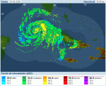
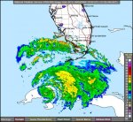
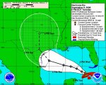
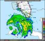
Hurricane Ike has completed its final traverse of Cuba, and is now over the warm waters of the Gulf of Mexico. All indications are that Ike will intensify into a very dangerous major hurricane that will hit the Texas coast Friday night or Saturday.
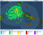
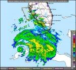
Key West radar shows that the inner eyewall of Ike has collapsed, but satellite loops show that Ike has maintained a large, well-organized circulation during its passage of Cuba. The 4 pm EDT center fix from the Hurricane Hunters found a central pressure of 968 mb, which is characteristic of a Category 2 hurricane. Passage over Cuba did not disrupt the storm enough to keep Ike from intensifying into a major hurricane over the Gulf of Mexico.
The capital of Havana missed the worst of Ike, and reported highest sustained winds of just 40 mph, gusting to 58 mph, at 8 am this morning. Ike killed four people in Cuba yesterday--the first hurricane deaths in Cuba this year. Cuba put in place its usual massive evacuation plan for Ike, evacuating 1.2 million residents. Considering the number of people affected and the violence of Category 4 Gustav and Category 3 Ike, Cuba's low death toll this year is a remarkable achievement.
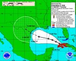
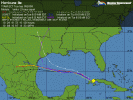
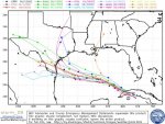
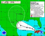
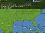
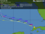
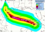
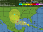
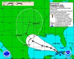
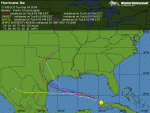
Track forecast for Ike
A trough of low pressure is currently passing to the north of Ike, and this trough has been able to turn Ike north of due west. Ike is now moving west-northwest, and this motion is expected to continue today. By Wednesday, Ike is expected to take a more westerly motion again, as high pressure to the north builds in. As Ike approaches Texas on Friday, a new trough of low pressure is expected to pass to the north, potentially turning Ike to the northwest.
The latest 12Z (8am EDT) computer models have come into much better agreement. All of the major models foresee a landfall between Corpus Christi and Galveston. Landfall would occur late Friday night or early Saturday morning, and tropical storm force winds would arrive at the coast on Friday morning. Given the inability of the models to agree until now, this landfall is certainly not a "sure thing", and the cone of uncertainty covers the entire coast of Texas. Data from the NOAA jet will go into tonight's 00Z (8 pm EDT) model runs, which will be available first thing Wednesday morning. That set of model runs should give us a pretty good idea of where Ike will go. I'm sure emergency managers are not eager to call for an evacuation of Houston, after the debacle of the evacuation for Hurricane Rita in 2005. Over 110 people died in the evacuation--far more than died in the storm. Still, there is a significant chance that an evacuation of large stretches of the Texas coast--including portions of Houston--will have to be ordered on Wednesday or Thursday.
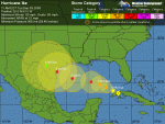
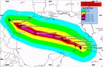
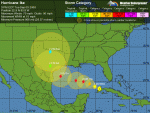
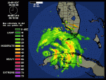
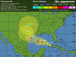
Intensity forecast for Ike
Ike survived the passage of Cuba well, and remains a large a well-organized hurricane. Significant strengthening will not occur until early Wednesday morning, since the storm has to build a new eyewall. Water temperatures are a warm 29.5°C in the Gulf of Mexico, and wind shear is expected to be modest, 10-15 knots.
Ike will be crossing over two regions of high heat content associated with the Loop Current and a Loop Current eddy.
The GFDL and HWRF models show Ike responding to these favorable conditions by intensifying to a Category 4 hurricane on Thursday. The wind shear for Friday has changed, and we are expecting wind shear to remain around 15 knots, which is still low enough to allow intensification. There is much higher oceanic heat content off the Texas coast than was present off the Louisiana coast for Gustav. Thus, it is less likely that Ike will significantly weaken as it approaches the coast.
The GFDL and HWRF models predict landfall in southern Texas as a Category 4 hurricane Friday night. The SHIPS model is less aggressive, and foresees a Category 1 hurricane at landfall.
Given the impressive appearance of Ike on satellite imagery, and the forecasts of high heat content and low shear along its path, I would be surprised if Ike hit as anything weaker than a Category 2 hurricane with 100 mph winds. Here's my rough probability break-down for Ike's strength at landfall, I forecast a 50% chance Ike will be a major hurricane at landfall:
Category 1 or weaker: 20%
Category 2: 30%
Category 3: 30%
Category 4 or 5: 20%
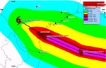
Texas is highly vulnerable to storm surge
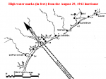
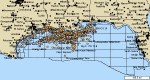
The Texas coast is highly vulnerable to large storm surges, due to the long expanse of shallow Continental Shelf waters offshore. The shallow depths allow large the swirling winds of the hurricane to pile up huge mounds of water, which then sweep inland when the hurricane makes landfall. Even Category 1 hurricanes are capable of generating 15 foot storm surges along some sections of the Texas coast. For example, the August 29, 1942 hurricane hit near Port O'Conner, Texas as a Category 1 storm with 80 mph winds. However, this hurricane had been a Category 3 storm with 115 mph winds the day before landfall, allowing it to pile up a large storm surge over the Continental Shelf just offshore the central Texas coast. The storm weakened suddenly in the 12 hours before landfall, but brought a storm surge characteristic of a Category 2 or 3 hurricane to shore. A 10-15 foot storm surge came ashore over a 100-mile stretch of coast between Port O'Conner and Freeport (Figure 1). Typical maximum storm surge values from a Category 4 hurricane hitting the central Texas coast at high tide are much higher, about 20-25 feet.
A realistic worse-case scenario for Texas
There is a significant chance that Ike will be the worst hurricane to hit Texas in over 40 years. The latest run of the HWRF and GFDL models paint a realistic worst-case scenario for Texas.
These models bring Ike to the coast as a Category 4 hurricane (which I give a 20% probability of happening).
The HWRF predicts a 170-mile stretch of coast will receive hurricane force winds of 74 mph or greater. A 100-mile stretch of coast will receive winds of Category 3 strength and higher, 115 mph. Hurricane force winds will push inland up to 50 miles, along a 50-mile wide region where the eyewall makes landfall. A 100-mile stretch of Texas coast will receive a storm surge of 10-15 feet, with bays just to the right of where the eye makes landfall receiving a 20-25 foot storm surge. This is what Hurricane Carla of 1961 did to Texas. Carla was a Category 4 hurricane with 145 mph winds at landfall, and drove a 10 foot or higher storm surge to a 180-mile stretch of Texas coast. A maximum storm surge of 22 feet was recorded at Port Lavaca, Texas. Despite the fact that the center of Carla hit over 120 miles southwest of Houston, the hurricane drove a 15-foot storm surge into the bays along the south side of the city.
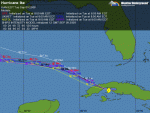
Elsewhere in the tropics
A area of disturbed weather near 10N, 21W, about 300 miles south of the Cape Verdes Islands, has changed little today. This morning's QuikSCAT pass showed a sloppy circulation and some 25 mph winds in heavy thunderstorms to the south. The region is currently under about 20 knots of shear, but shear is expected to decline over the disturbance as it moves west-northwest at 10-15 mph this week. No models currently predict development of this disturbance, but it is worth keeping an eye on. The disturbance will be near the northern Lesser Antilles Islands 7-8 days from now.
The remains of Tropical Storm Josephine are no longer a threat.
I'll have an update tonight by 9pm EDT, with the latest model runs for Ike, and more storm surge info for Texas.
Jeff Masters
Figure 4. High water marks from the August 29, 1942 hurricane along the Texas coast. Image credit: "Characteristics of the Hurricane Storm Surge", by D. Lee Harris, U.S. Weather Bureau, 1963.