penumbra
centrist member
000
WTNT44 KNHC 060259
TCDAT4
HURRICANE IKE DISCUSSION NUMBER 20
NWS TPC/NATIONAL HURRICANE CENTER MIAMI FL AL092008
1100 PM EDT FRI SEP 05 2008
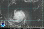
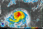
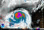
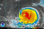
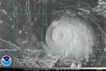
THE EYE OF IKE BRIEFLY RE-APPEARED AROUND 0000 UTC. SINCE THAT
TIME AN INTERMITTENT WARM SPOT HAS BEEN SEEN IN THE CENTRAL DENSE
OVERCAST IN CONVENTIONAL SATELLITE IMAGERY. THE LATEST MICROWAVE
IMAGERY FROM JUST PRIOR TO 0000 UTC INDICATED THAT THE EYE HAD A
SMALL OPENING IN THE NORTHWESTERN QUADRANT...OTHERWISE THE
INNER-CORE REMAINS WELL INTACT. SUBJECTIVE AND OBJECTIVE DVORAK
INTENSITY ESTIMATES ARE BETWEEN T5.5 AND 6.0...AND THE ADVISORY
INTENSITY WILL REMAIN 100 KT...OR AT THE LOWER END OF THOSE
ESTIMATES. ANOTHER AIR FORCE RESERVE HURRICANE HUNTER AIRCRAFT IS
SCHEDULED TO INVESTIGATE IKE AROUND 0600 UTC...WHICH SHOULD PROVIDE
A MORE ACCURATE ASSESSMENT OF IKE'S STRENGTH.
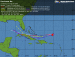
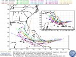
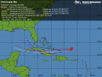
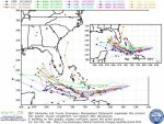
IKE CONTINUES TO MOVE BRISKLY WEST-SOUTHWESTWARD AT ABOUT 14 KT.
IKE IS BEING STEERED IN THAT DIRECTION DUE TO A MID-LEVEL RIDGE THAT
EXTENDS FROM NEAR BERMUDA SOUTHWESTWARD BETWEEN IKE AND HANNA.
THIS RIDGE IS FORECAST TO GRADUALLY SHIFT NORTHWARD DURING THE NEXT
COUPLE OF DAYS. AS THIS HAPPENS...IKE IS EXPECTED TO GRADUALLY TURN
MORE WESTWARD. THE TRACK GUIDANCE HAS COME INTO BETTER AGREEMENT
ON THIS SOLUTION...AND HAS ONCE AGAIN SHIFTED SOUTH AND WESTWARD.
IN FACT...MOST OF THE RELIABLE GUIDANCE NOW TAKES HANNA EITHER OVER
OR ALONG THE NORTH COAST OF CUBA. THE NEW TRACK HAS BEEN SHIFTED
SOUTH AND WESTWARD OF THE PREVIOUS ADVISORY...AND IT IS ALSO A
LITTLE FASTER. IT SHOULD BE NOTED...THAT THE DYNAMICAL MODEL
CONSENSUS AND SEVERAL OF THE INDIVIDUAL MODELS ARE SOUTHWEST
OF THE 4 AND 5 DAY NHC POSITIONS AND IF THIS TREND CONTINUES
SOME ADDITIONAL WESTWARD SHIFT COULD BE REQUIRED.
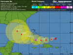
THE NORTHEASTERLY SHEAR CURRENTLY DISRUPTING THE HURRICANE IS
FORECAST TO ABATE DURING THE NEXT 12 TO 24 HOURS. SINCE
IKE...STILL APPEARS TO BE A VERY HEALTHY HURRICANE...LITTLE IF ANY
ADDITIONAL WEAKENING IS EXPECTED BEFORE IT REACHES THE SOUTHEASTERN
BAHAMAS. BEYOND 36 HOURS...THE SHEAR IS FORECAST TO BE VERY LIGHT
AND THE ONLY NEGATIVE FACTOR FOR STRENGTHENING WILL BE POSSIBLE LAND
INTERACTION. WITH THE OFFICIAL TRACK PREDICTION ALONG THE NORTHERN
COAST OF CUBA...IT SHOWS ONLY SLIGHT WEAKENING DUE TO LAND.
HOWEVER...IKE COULD BE WEAKER THAN SHOWN BELOW IF THE CENTER
MOVES OVER CUBA...AND CONVERSELY COULD BE A LITTLE STRONGER IF IT
REMAINS OVER WATER.
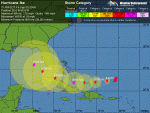
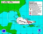
FORECAST POSITIONS AND MAX WINDS
INITIAL 06/0300Z 22.6N 65.6W 100 KT
12HR VT 06/1200Z 22.3N 67.6W 100 KT
24HR VT 07/0000Z 22.0N 70.3W 100 KT
36HR VT 07/1200Z 21.9N 72.8W 105 KT
48HR VT 08/0000Z 21.9N 75.3W 115 KT
72HR VT 09/0000Z 22.9N 79.6W 110 KT
96HR VT 10/0000Z 24.5N 82.5W 110 KT
120HR VT 11/0000Z 26.0N 84.5W 115 KT
$$
FORECASTER BROWN/AVILA
WTNT44 KNHC 060259
TCDAT4
HURRICANE IKE DISCUSSION NUMBER 20
NWS TPC/NATIONAL HURRICANE CENTER MIAMI FL AL092008
1100 PM EDT FRI SEP 05 2008
THE EYE OF IKE BRIEFLY RE-APPEARED AROUND 0000 UTC. SINCE THAT
TIME AN INTERMITTENT WARM SPOT HAS BEEN SEEN IN THE CENTRAL DENSE
OVERCAST IN CONVENTIONAL SATELLITE IMAGERY. THE LATEST MICROWAVE
IMAGERY FROM JUST PRIOR TO 0000 UTC INDICATED THAT THE EYE HAD A
SMALL OPENING IN THE NORTHWESTERN QUADRANT...OTHERWISE THE
INNER-CORE REMAINS WELL INTACT. SUBJECTIVE AND OBJECTIVE DVORAK
INTENSITY ESTIMATES ARE BETWEEN T5.5 AND 6.0...AND THE ADVISORY
INTENSITY WILL REMAIN 100 KT...OR AT THE LOWER END OF THOSE
ESTIMATES. ANOTHER AIR FORCE RESERVE HURRICANE HUNTER AIRCRAFT IS
SCHEDULED TO INVESTIGATE IKE AROUND 0600 UTC...WHICH SHOULD PROVIDE
A MORE ACCURATE ASSESSMENT OF IKE'S STRENGTH.
IKE CONTINUES TO MOVE BRISKLY WEST-SOUTHWESTWARD AT ABOUT 14 KT.
IKE IS BEING STEERED IN THAT DIRECTION DUE TO A MID-LEVEL RIDGE THAT
EXTENDS FROM NEAR BERMUDA SOUTHWESTWARD BETWEEN IKE AND HANNA.
THIS RIDGE IS FORECAST TO GRADUALLY SHIFT NORTHWARD DURING THE NEXT
COUPLE OF DAYS. AS THIS HAPPENS...IKE IS EXPECTED TO GRADUALLY TURN
MORE WESTWARD. THE TRACK GUIDANCE HAS COME INTO BETTER AGREEMENT
ON THIS SOLUTION...AND HAS ONCE AGAIN SHIFTED SOUTH AND WESTWARD.
IN FACT...MOST OF THE RELIABLE GUIDANCE NOW TAKES HANNA EITHER OVER
OR ALONG THE NORTH COAST OF CUBA. THE NEW TRACK HAS BEEN SHIFTED
SOUTH AND WESTWARD OF THE PREVIOUS ADVISORY...AND IT IS ALSO A
LITTLE FASTER. IT SHOULD BE NOTED...THAT THE DYNAMICAL MODEL
CONSENSUS AND SEVERAL OF THE INDIVIDUAL MODELS ARE SOUTHWEST
OF THE 4 AND 5 DAY NHC POSITIONS AND IF THIS TREND CONTINUES
SOME ADDITIONAL WESTWARD SHIFT COULD BE REQUIRED.
THE NORTHEASTERLY SHEAR CURRENTLY DISRUPTING THE HURRICANE IS
FORECAST TO ABATE DURING THE NEXT 12 TO 24 HOURS. SINCE
IKE...STILL APPEARS TO BE A VERY HEALTHY HURRICANE...LITTLE IF ANY
ADDITIONAL WEAKENING IS EXPECTED BEFORE IT REACHES THE SOUTHEASTERN
BAHAMAS. BEYOND 36 HOURS...THE SHEAR IS FORECAST TO BE VERY LIGHT
AND THE ONLY NEGATIVE FACTOR FOR STRENGTHENING WILL BE POSSIBLE LAND
INTERACTION. WITH THE OFFICIAL TRACK PREDICTION ALONG THE NORTHERN
COAST OF CUBA...IT SHOWS ONLY SLIGHT WEAKENING DUE TO LAND.
HOWEVER...IKE COULD BE WEAKER THAN SHOWN BELOW IF THE CENTER
MOVES OVER CUBA...AND CONVERSELY COULD BE A LITTLE STRONGER IF IT
REMAINS OVER WATER.
FORECAST POSITIONS AND MAX WINDS
INITIAL 06/0300Z 22.6N 65.6W 100 KT
12HR VT 06/1200Z 22.3N 67.6W 100 KT
24HR VT 07/0000Z 22.0N 70.3W 100 KT
36HR VT 07/1200Z 21.9N 72.8W 105 KT
48HR VT 08/0000Z 21.9N 75.3W 115 KT
72HR VT 09/0000Z 22.9N 79.6W 110 KT
96HR VT 10/0000Z 24.5N 82.5W 110 KT
120HR VT 11/0000Z 26.0N 84.5W 115 KT
$$
FORECASTER BROWN/AVILA