Jarhead
Has No Life - Lives on TB
Crown Weather Services
Tropical Weather Discussion
Issued: Thursday, September 4, 2008
--------------------------------------------------------------------------------
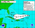
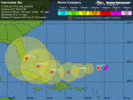
Hurricane Ike:
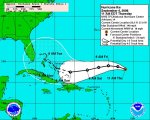
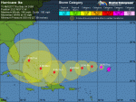
Of much more concern now is Hurricane Ike. This hurricane has undergone major intensification over the last 24 hours and as of early this morning is a powerful 145 mph Category 4 hurricane. Satellite imagery shows an eye embedded in very cold cloud tops. The latest SHIPS intensity model shows 30 knots or more of wind shear over Ike within the next 24 to 36 hours due to a strengthening high pressure system to the northwest of the hurricane. This large-scale environmental influence should knock Ike down to a Category 3 hurricane by late Friday.
After Saturday, some restrengthening is probable as the shear weakens and the thermodynamic environment is expected to be favorable and Ike may strengthen back up to a Category 4 hurricane by later Sunday or Monday.
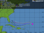
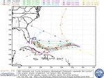
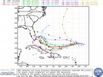
Ike is tracking west-northwest at a forward speed of 17 mph. A ridge of high pressure is forecast by the global models to build to the northwest of Ike within the next couple of days. This weather pattern would likely cause the heading of Ike to bend to the west and even west-southwest.
By Monday and Tuesday, it is expected that Ike will have passed the center of the high and turn back to a west to west-northwest heading.
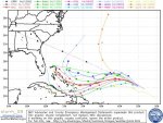
One very large question is how Ike responds to the weakness in the ridge of high pressure over the southeastern United States on Tuesday.
The European model is the westernmost model and forecasts Ike to track right up the east coast of Florida from Miami to Daytona Beach on Tuesday and Wednesday.
The GFS model is the most eastern model and keeps the hurricane offshore and does not make landfall.
The Canadian model is somewhere in the middle and forecasts a hurricane to track up the US East Coast from Tuesday evening to Friday evening.
Based on this and looking at the two extremes, the middle approach of the Canadian model may be best for now, however, either one of these scenarios could occur in the end and all interests along the entire US East Coast should pay close attention to the progress of Hurricane Ike.
The next tropical weather discussion will be issued by 7 am EDT Friday morning.
Tropical Weather Discussion
Issued: Thursday, September 4, 2008
--------------------------------------------------------------------------------
Hurricane Ike:
Of much more concern now is Hurricane Ike. This hurricane has undergone major intensification over the last 24 hours and as of early this morning is a powerful 145 mph Category 4 hurricane. Satellite imagery shows an eye embedded in very cold cloud tops. The latest SHIPS intensity model shows 30 knots or more of wind shear over Ike within the next 24 to 36 hours due to a strengthening high pressure system to the northwest of the hurricane. This large-scale environmental influence should knock Ike down to a Category 3 hurricane by late Friday.
After Saturday, some restrengthening is probable as the shear weakens and the thermodynamic environment is expected to be favorable and Ike may strengthen back up to a Category 4 hurricane by later Sunday or Monday.
Ike is tracking west-northwest at a forward speed of 17 mph. A ridge of high pressure is forecast by the global models to build to the northwest of Ike within the next couple of days. This weather pattern would likely cause the heading of Ike to bend to the west and even west-southwest.
By Monday and Tuesday, it is expected that Ike will have passed the center of the high and turn back to a west to west-northwest heading.
One very large question is how Ike responds to the weakness in the ridge of high pressure over the southeastern United States on Tuesday.
The European model is the westernmost model and forecasts Ike to track right up the east coast of Florida from Miami to Daytona Beach on Tuesday and Wednesday.
The GFS model is the most eastern model and keeps the hurricane offshore and does not make landfall.
The Canadian model is somewhere in the middle and forecasts a hurricane to track up the US East Coast from Tuesday evening to Friday evening.
Based on this and looking at the two extremes, the middle approach of the Canadian model may be best for now, however, either one of these scenarios could occur in the end and all interests along the entire US East Coast should pay close attention to the progress of Hurricane Ike.
The next tropical weather discussion will be issued by 7 am EDT Friday morning.