Jarhead
Has No Life - Lives on TB
000
WTUS84 KEWX 121522
HLSEWX
URGENT - IMMEDIATE BROADCAST REQUESTED
HURRICANE IKE LOCAL STATEMENT
NATIONAL WEATHER SERVICE AUSTIN/SAN ANTONIO TX
1022 AM CDT FRI SEP 12 2008
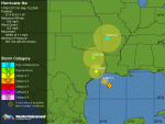
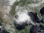
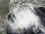
...DANGEROUS HURRICANE IKE HEADED FOR THE UPPER TEXAS COAST...
.AT 1000 AM CDT...1500Z...THE CENTER OF HURRICANE IKE WAS LOCATED
NEAR LATITUDE 27.2 NORTH...LONGITUDE 92.6 WEST OR ABOUT
295 MILES... 480 KM...EAST OF CORPUS CHRISTI TEXAS AND ABOUT
195 MILES...320 KM ...SOUTHEAST OF GALVESTON TEXAS.
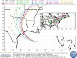
IKE IS MOVING TOWARD THE WEST-NORTHWEST NEAR 12 MPH...19 KM/HR. A
TURN TOWARD THE NORTHWEST IS EXPECTED LATER TODAY...WITH A TURN
TOWARD THE NORTH EXPECTED ON SATURDAY. ON THE FORECAST TRACK...
THE CENTER OF IKE WILL BE VERY NEAR THE UPPER TEXAS COAST BY LATE
TODAY OR EARLY SATURDAY. HOWEVER...BECAUSE IKE IS A VERY LARGE
TROPICAL CYCLONE...WEATHER WILL BEGIN TO DETERIORATE ALONG THE
COASTLINE SOON.
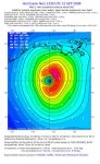
MAXIMUM SUSTAINED WINDS REMAIN NEAR 105 MPH...165 KM/HR...WITH
HIGHER GUSTS. IKE IS A CATEGORY TWO HURRICANE ON THE SAFFIR-
SIMPSON SCALE BUT COULD REACH THE COAST AS A CATEGORY THREE...
MAJOR HURRICANE. STRONGER WINDS...ESPECIALLY IN GUSTS...ARE
LIKELY ON HIGH RISE BUILDINGS.
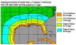
IKE REMAINS A VERY LARGE TROPICAL CYCLONE. HURRICANE FORCE WINDS
EXTEND OUTWARD UP TO 120 MILES...195 KM...FROM THE CENTER...AND
TROPICAL STORM FORCE WINDS EXTEND OUTWARD UP TO 275 MILES...
445 KM.
ESTIMATED MINIMUM CENTRAL PRESSURE FROM A RECONNAISSANCE AIRCRAFT
IS 954 MB...28.17 INCHES.
TXZ193-194-209-223>225-121930-
/O.CON.KEWX.TI.W.0001.080913T0000Z-080914T0000Z/
BASTROP-LEE-FAYETTE-GONZALES-DE WITT-LAVACA-
1022 AM CDT FRI SEP 12 2008
...TROPICAL STORM WIND WARNING REMAINS IN EFFECT FROM 7 PM THIS
EVENING TO 7 PM CDT SATURDAY...
...AREAS AFFECTED...
THIS STATEMENT RECOMMENDS ACTIONS TO BE TAKEN BY PERSONS IN...
BASTROP...DE WITT...FAYETTE...GONZALES...LAVACA AND LEE COUNTIES
OF SOUTH CENTRAL TEXAS.
...WATCHES/WARNINGS...
A TROPICAL STORM WIND WARNING IS IN EFFECT FOR BASTROP...DE WITT...
FAYETTE...GONZALES...LAVACA AND LEE COUNTIES SOUTH CENTRAL TEXAS
FOR THIS EVENING THROUGH SATURDAY AFTERNOON.
...PRECAUTIONARY/PREPAREDNESS ACTIONS...
MINOR DAMAGE WILL OCCUR TO MANY MOBILE HOMES. POORLY CONSTRUCTED
HOMES MAY RECEIVE SOME WALL DAMAGE AND PARTIAL ROOF REMOVAL. A FEW
HOUSES MAY HAVE MINOR DAMAGE TO ROOF SHINGLES AND SIDING. A FEW
POOL CAGES AND LANAI SCREENS WILL BE DAMAGED. UNSECURED
LIGHTWEIGHT ITEMS MAY BECOME PROJECTILES...CAUSING ADDITIONAL
DAMAGE. SOME ELECTRICAL WIRES WILL BE BLOWN DOWN...AND LOCAL POWER
OUTAGES ARE LIKELY. MOST NEWLY PLANTED TREES AND SHRUBS WILL BE
DAMAGED OR UPROOTED. SOME ROTTING SMALL TREES WILL BE
UPROOTED...AND ROTTEN LARGE BRANCHES WILL SNAP. NUMEROUS SMALL
TWIGS WILL SEPARATE FROM TREES.
...WINDS...
TROPICAL STORM FORCE NORTH TO NORTHWEST WINDS OF 39 TO 50 MPH
WITH GUSTS TO 60 MPH CAN BE EXPECTED. WINDS WILL SLOWLY TAPER OFF
SATURDAY AFTERNOON AS IKE MOVES INTO NORTHEASTERN TEXAS.
...INLAND FLOODING...
IKE IS EXPECTED TO PRODUCE RAINFALL AMOUNTS OF 3 TO 5 INCHES WITH
ISOLATED AMOUNTS TO NEAR 6 INCHES OVER EASTERN PARTS OF SOUTH
CENTRAL TEXAS TONIGHT THROUGH SATURDAY. THIS MAY CAUSE LOCALIZED
FLOODING.
...TORNADOES...
ISOLATED TORNADOES ARE POSSIBLE OVER EASTERN PORTIONS OF SOUTH
CENTRAL TEXAS ON SATURDAY.
...NEXT UPDATE...
THIS STATEMENT WILL BE UPDATED NO LATER THAN 2 PM CDT.
$$
WTUS84 KEWX 121522
HLSEWX
URGENT - IMMEDIATE BROADCAST REQUESTED
HURRICANE IKE LOCAL STATEMENT
NATIONAL WEATHER SERVICE AUSTIN/SAN ANTONIO TX
1022 AM CDT FRI SEP 12 2008
...DANGEROUS HURRICANE IKE HEADED FOR THE UPPER TEXAS COAST...
.AT 1000 AM CDT...1500Z...THE CENTER OF HURRICANE IKE WAS LOCATED
NEAR LATITUDE 27.2 NORTH...LONGITUDE 92.6 WEST OR ABOUT
295 MILES... 480 KM...EAST OF CORPUS CHRISTI TEXAS AND ABOUT
195 MILES...320 KM ...SOUTHEAST OF GALVESTON TEXAS.
IKE IS MOVING TOWARD THE WEST-NORTHWEST NEAR 12 MPH...19 KM/HR. A
TURN TOWARD THE NORTHWEST IS EXPECTED LATER TODAY...WITH A TURN
TOWARD THE NORTH EXPECTED ON SATURDAY. ON THE FORECAST TRACK...
THE CENTER OF IKE WILL BE VERY NEAR THE UPPER TEXAS COAST BY LATE
TODAY OR EARLY SATURDAY. HOWEVER...BECAUSE IKE IS A VERY LARGE
TROPICAL CYCLONE...WEATHER WILL BEGIN TO DETERIORATE ALONG THE
COASTLINE SOON.
MAXIMUM SUSTAINED WINDS REMAIN NEAR 105 MPH...165 KM/HR...WITH
HIGHER GUSTS. IKE IS A CATEGORY TWO HURRICANE ON THE SAFFIR-
SIMPSON SCALE BUT COULD REACH THE COAST AS A CATEGORY THREE...
MAJOR HURRICANE. STRONGER WINDS...ESPECIALLY IN GUSTS...ARE
LIKELY ON HIGH RISE BUILDINGS.
IKE REMAINS A VERY LARGE TROPICAL CYCLONE. HURRICANE FORCE WINDS
EXTEND OUTWARD UP TO 120 MILES...195 KM...FROM THE CENTER...AND
TROPICAL STORM FORCE WINDS EXTEND OUTWARD UP TO 275 MILES...
445 KM.
ESTIMATED MINIMUM CENTRAL PRESSURE FROM A RECONNAISSANCE AIRCRAFT
IS 954 MB...28.17 INCHES.
TXZ193-194-209-223>225-121930-
/O.CON.KEWX.TI.W.0001.080913T0000Z-080914T0000Z/
BASTROP-LEE-FAYETTE-GONZALES-DE WITT-LAVACA-
1022 AM CDT FRI SEP 12 2008
...TROPICAL STORM WIND WARNING REMAINS IN EFFECT FROM 7 PM THIS
EVENING TO 7 PM CDT SATURDAY...
...AREAS AFFECTED...
THIS STATEMENT RECOMMENDS ACTIONS TO BE TAKEN BY PERSONS IN...
BASTROP...DE WITT...FAYETTE...GONZALES...LAVACA AND LEE COUNTIES
OF SOUTH CENTRAL TEXAS.
...WATCHES/WARNINGS...
A TROPICAL STORM WIND WARNING IS IN EFFECT FOR BASTROP...DE WITT...
FAYETTE...GONZALES...LAVACA AND LEE COUNTIES SOUTH CENTRAL TEXAS
FOR THIS EVENING THROUGH SATURDAY AFTERNOON.
...PRECAUTIONARY/PREPAREDNESS ACTIONS...
MINOR DAMAGE WILL OCCUR TO MANY MOBILE HOMES. POORLY CONSTRUCTED
HOMES MAY RECEIVE SOME WALL DAMAGE AND PARTIAL ROOF REMOVAL. A FEW
HOUSES MAY HAVE MINOR DAMAGE TO ROOF SHINGLES AND SIDING. A FEW
POOL CAGES AND LANAI SCREENS WILL BE DAMAGED. UNSECURED
LIGHTWEIGHT ITEMS MAY BECOME PROJECTILES...CAUSING ADDITIONAL
DAMAGE. SOME ELECTRICAL WIRES WILL BE BLOWN DOWN...AND LOCAL POWER
OUTAGES ARE LIKELY. MOST NEWLY PLANTED TREES AND SHRUBS WILL BE
DAMAGED OR UPROOTED. SOME ROTTING SMALL TREES WILL BE
UPROOTED...AND ROTTEN LARGE BRANCHES WILL SNAP. NUMEROUS SMALL
TWIGS WILL SEPARATE FROM TREES.
...WINDS...
TROPICAL STORM FORCE NORTH TO NORTHWEST WINDS OF 39 TO 50 MPH
WITH GUSTS TO 60 MPH CAN BE EXPECTED. WINDS WILL SLOWLY TAPER OFF
SATURDAY AFTERNOON AS IKE MOVES INTO NORTHEASTERN TEXAS.
...INLAND FLOODING...
IKE IS EXPECTED TO PRODUCE RAINFALL AMOUNTS OF 3 TO 5 INCHES WITH
ISOLATED AMOUNTS TO NEAR 6 INCHES OVER EASTERN PARTS OF SOUTH
CENTRAL TEXAS TONIGHT THROUGH SATURDAY. THIS MAY CAUSE LOCALIZED
FLOODING.
...TORNADOES...
ISOLATED TORNADOES ARE POSSIBLE OVER EASTERN PORTIONS OF SOUTH
CENTRAL TEXAS ON SATURDAY.
...NEXT UPDATE...
THIS STATEMENT WILL BE UPDATED NO LATER THAN 2 PM CDT.
$$


") Looks like St. Louis is expected to have heavy rain on Saturday into Sunday - but clearing by Sunday night.
Looks like St. Louis is expected to have heavy rain on Saturday into Sunday - but clearing by Sunday night.