WEATHER Hurricane Ike Daily Thread for Thursday/ 9-11-08

Status
Not open for further replies.
Does anyone have the 8 zip codes that have been ordered mandatory evacuation? I've heard of them but can't tell if Pearland is on the list. The eye shows going to the west of there and the bay is just east of the city. I need to tell my sister to get out of there now.

She left during Rita to come to Dallas, but they had to go to Corpus instead as they sat in the same place on the highway for 3 hours.

She said they'd never leave again due to that situation.
 

The Traveler

Veteran Member
Got this from Storm2k

Does anyone have the 8 zip codes that have been ordered mandatory evacuation? I've heard of them but can't tell if Pearland is on the list. The eye shows going to the west of there and the bay is just east of the city. I need to tell my sister to get out of there now.

She left during Rita to come to Dallas, but they had to go to Corpus instead as they sat in the same place on the highway for 3 hours.

She said they'd never leave again due to that situation.

Harris County Judge Ed Emmett called for mandatory evacuations of low-lying areas starting at noon today. Those residents are in evacuation zones A and B, specifically ZIP codes 77058, 77059, 77062, 77520, 77546, 77571, 77586 and 77598.
 

sassy

Veteran Member
Does anyone have the 8 zip codes that have been ordered mandatory evacuation? I've heard of them but can't tell if Pearland is on the list. The eye shows going to the west of there and the bay is just east of the city. I need to tell my sister to get out of there now.

She left during Rita to come to Dallas, but they had to go to Corpus instead as they sat in the same place on the highway for 3 hours.

She said they'd never leave again due to that situation.

* 77058
* 77059
* 77062
* 77520
* 77546
* 77571
* 77586
77598

Those ZIP codes are zones A and B of the county's evacuation plan. It is possible that residents in those areas could be affected by the storm surge.
 

sassy

Veteran Member
Just got home. Wow, things are pretty wild out there! But everyone is calm.

Son got the plywood. He and my hubby will be boarding up the house this evening.

My job was to get a new chainsaw blade - done.
Get my meds refilled - done.
Get more whatever - done.
Top off tank - done.
Get cash - done.

The store was out of water, very low on can goods, very few packages of toilet paper, no tuna, no canned chicken or soup!

I don't know if this is a good idea or not - seems corny right now but
I am going to bake cookies, cook a pot of butter beans with sausage and some cabbage with bacon. Oh, and make cornbread.


BTW Thanks everyone out there praying!
 

gisgaia

Veteran Member
The KHOU link that Jarhead posted above is very good - live coverage from Houston:

http://www.khou.com/video/?nvid=178826&live=yes&noad=yes

The Belo company in Texas runs as station on cable called "TXCN" and they show news continously from the major Texas cities 24/7 ... however since yesterday they've been doing full live coverage of KHOU so I've been watching nonstop past 24 hours now.

Here's what I know from what's been on there this morning:

> All officials speaking live this morning are emphasizing how they are now very behind schedule for such a large-scale evacuation as this one is now beoming ... that the focus on Corpus Christi being the forecasted landfall yesterday has now put them on very short notice. They are still debating on when or if to start up the "Contra-flow" plans for freeways to all out outbound in Houston... that it can be a real serious problem for people trying to get home & fetch their families after they get off work later today.

> Gov Perry had news conf about 2 hrs ago (11 am CDT) - he said that he has now been informed, according to latest estimates of this storm's intensification - etc, that 1.5 million people could die if they are not evacuated immediately from the highest danger areas (surge areas?) as this storm comes in Friday night. (I definitely sensed that there is more to this story as he & all the officials around him all looked spooked)

> Currently, they are stressing that everyone outside the official evacuation areas in Houston (mandatory zones due to have surge flooding over 15 feet) should just stay put and get ready to hunker down (See my note) The reason for this is because those in extreme danger down south of the city along the low areas (south of Friendswood & NASA regions) and then the outlying coastal regions MUST get out now as a top priority!!!

[My note: having worked as a disaster coordinator for Red Cross in past years, it is important that people with serious medical issues or newborns, etc get OUT of the area, even if they are not in surge zone - as these could die or have serious complications from exposure that occurs in the post -disaster phase. That is like what we saw with Katrina when so many were stranded and were not being "rescued" promptly. There are some folks of all ages that would be quickly endangered (life or death) if stranded more than a day or so without electricity, AC, water & meds, shelter, and essential services. Medical: heart patients, diabetics, elderly or disabled that are homebound or bed-ridden, adults & children with serious disabilities / medical impairments.

> Earlier this morning they showed a map of the expected *heavy* damage zone (= no power for weeks, trees down, roofs missing - etc) around Houston if Ike comes in there - especially with the right-front quadrant sweeping directly over the Houston metro region & going north right up I-45. That zone map went up as far north as A&M University and extended east to Huntsville and then circled southeast towards Louisiana border.

> Right now on KHOU the local officials are talking of fuel shortage issues, that everyone CANNOT just go top off their tanks or there is not going to be adequate fuel for those in the areas that absolutely must evacuate! Something about how that happened in 1973 ... they are monitoring all emergency fueling stations and trying to plan for afternoon rush hour.

Phone call from Houston relatives .. .more shortly!
 
Earlier this morning they showed a map of the expected *heavy* damage zone (= no power for weeks, trees down, roofs missing - etc) around Houston if Ike comes in there - especially with the right-front quadrant sweeping directly over the Houston metro region & going north right up I-45. That zone map went up as far north as A&M University and extended east to Huntsville and then circled southeast towards Louisiana border.

I'd love to see that map if anyone could find & post it.
 

blueberry

Inactive
I don't know if this is a good idea or not - seems corny right now but
I am going to bake cookies, cook a pot of butter beans with sausage and some cabbage with bacon. Oh, and make cornbread.

Doesn't sound corny to me! Having food ready to eat is always a good thing.

Stay safe, everybody.
 

Red Baron

Paleo-Conservative
_______________
Looks like a case of fixating on only the center of the forecast track and not on the "cone of uncertainty".

It's called a cone of uncertainty for a reason. For the media and public officials to focus only on the center is very dangerous.

Additionally,

Not the local gas shortage crap again. Didn't anyone learn from Katrina and the last evacuation of Houston? The oil companies and the National Guard need to station fuel tankers all along the evacuation routes.
 

DustMusher

Deceased
My dear friends and rescue associates are about 10 miles south of Brenham about an hour SSW of Texas A&M. Because of the number of the dogs on their property (19 Malamutes) they have no option but SIP.

Their daughter's family and her dogs (also a rescuer) are also SIP - I just talked to her - she is near NASA. Expressways I45S is stop and go. Surface streets are jammed -- all 3 lanes of one road were jammed by people trying to get into Home Depot.

My DD teaches at A&M and had to drive into College Station from Austin then return tonight.

I am getting ready for tropical storm winds (news is saying 40 -50 MPH IF it hits near Galvaston or south.

Not gonna be posting much. Reading a lot, though!

When I decided to be a Sheepdog, I didn't realize how much effort goes into calming a paniced flock and reinforcing the Sheepdogs in training.

DM
 

Rubythedane

Contributing Member
We're riding this one out like Rita

We live in Northwest Jefferson county and plan on riding this one out like we did in Rita. All the schools are closed and another mandatory evac has been called for my county and surrounding counties.

We added a hurricane/laundry room after sleeping under the stairwell when Rita hit. Hubby built it out of steel bolted to the foundation, it's air conditioned by a small window unit that can easily be powered by our generator. We prepared well for gustav and haved all our hurricane preps (including plenty of fuel for the genny). We did board-up some windows this time on the south side of the house.

We own so many animals (4 dogs one of which is a great dane & 4 cats) that it's not practical for us to evacuate unless my hubby builds an animal trailer.

Just heard that the shoulder evac lanes have been opened up on the evac routes out of the area. Don't know when or if contra-flow will be activated.

I'll post some updates if anyone is interested for as long as the power lasts.
 

Haybails

When In Doubt, Throttle Out!
We live in Northwest Jefferson county and plan on riding this one out like we did in Rita. All the schools are closed and another mandatory evac has been called for my county and surrounding counties.

We added a hurricane/laundry room after sleeping under the stairwell when Rita hit. Hubby built it out of steel bolted to the foundation, it's air conditioned by a small window unit that can easily be powered by our generator. We prepared well for gustav and haved all our hurricane preps (including plenty of fuel for the genny). We did board-up some windows this time on the south side of the house.

We own so many animals (4 dogs one of which is a great dane & 4 cats) that it's not practical for us to evacuate unless my hubby builds an animal trailer.

Just heard that the shoulder evac lanes have been opened up on the evac routes out of the area. Don't know when or if contra-flow will be activated.

I'll post some updates if anyone is interested for as long as the power lasts.

Definately interested here. Thanx.

But, most of all, Stay safe!!

HB
 
I got my extra water and batteries etc this morning. The grocery store was packed. School dist just called and said no school tomorrow. Hubby told all his people at work to stay home tomorrow, he said several left early to head out before 45 becomes a parking lot. Tomorrow is gonna be a very long day.
Hoping for the best!
 

gisgaia

Veteran Member
Earlier this morning they showed a map of the expected *heavy* damage zone (= no power for weeks, trees down, roofs missing - etc) around Houston if Ike comes in there - especially with the right-front quadrant sweeping directly over the Houston metro region & going north right up I-45. That zone map went up as far north as A&M University and extended east to Huntsville and then circled southeast towards Louisiana border.

I'd love to see that map if anyone could find & post it.

--------------------------

Dancer, go check out that KHOU website - likely have it on there.

Right now watching KHOU live, the forecaster is going over that map and pointing out each area - county by county + towns ... he is saying there will likely be roofs off and trees / power poles down all the way north up to Brenham & College Station - cause there will be winds sustained 60-80 mph as Ike comes inland, very powerfull ... something about unusual characteristics (why?)

Saying in Conroe winds could top @ 70 mph but that is if the eyewall passes off further west, otherwise it would be higher like 90-100mph. Now he's showing towns of Cypress & Katy = winds would be @ 95 mph.... and that Wharton - El Campo could be around 90 mph if the eyewall passes directly over them.

Sugarland, Pearland & Friendswood may have winds of 90-100 mph but areas just west of there (pointing to Fort Bend County) could be even higher @ 110 mph. That areas more south towards beach will be worse ---> Freeport + Angleton @ 110-120 mph sustained.

He is saying all his estimates are per the latest projected landfall at this time but if there is even a bit of a wobble to the east, where eyewall comes in over west end of Galveston Island & moves up directly over areas like Friendswood & Clearlake (where NASA Johnson Command Center is based) then there is going to be unbelievable catastrophes taking place.

Folks, this scenario, even as it is right now, is very, very dangerous! If only you could see the extensive area of chemical plants & huge refineries that line the corridor between Houston & Galveston along the ship channel for miles & miles. Even without a direct eyewall hit in that corridor, the force of the surge + tornadoes dipping down in the feeder bands along with heavy flooding damaging those facilities could lead to explosions or bizarre toxic gas releases or ??? I've seen way too much bad stuff happen to people that didn't take things serious till too late ... we would certainly would be getting the heck outta Dodge in those parts.

BRB ... got hot news for other parts of Texas to add !
 

Rubythedane

Contributing Member
Texas A & M has cancelled Friday classes.

DustMusher-Got a call from my son saying classes cancelled @ a A & M on Friday.
 
Thanks gisgaia, you always give the best reports!

Also, Houston Bay and ship channel problems. Won't the bay overflow into towns (surge) like Friendswood & Pearland? It will make the NOLA Katrina mess look like kindergarten play.

This could be the devistation someone had predicted for Sept. 12th????

Texas City will be hit hard and we all know the refineries there could pose many a problem.

This could be the fustercluck of all fustercluks. FUBAR to the max in more way than you could ever think.
 

Army Girl

Inactive
Do you think flights going into San Antonio scheduled for friday evening will be affected? Is San Antonio going to see any of this storm damage?
 

gisgaia

Veteran Member
Okay, back for a few more minutes then I have to go into disaster prep mode even here in DFW !!

(Thanks for the nice compliment, D-Dancer, I love this board ;))

ALERT -- CNN announced just now @ 2:10pm CDT they are fixing to do a special update coming up next, will be showing where they think there will be heavy damage around the Houston region (outlying areas) with estimates of wind speeds etc.

Wait a sec ... another phone call incoming
 

RedheadGI

Contributing Member
Dear Lord! God Bless all in harm's way!

"HURRICANE IKE LOCAL STATEMENT
NATIONAL WEATHER SERVICE HOUSTON/GALVESTON TX
120 PM CDT THU SEP 11 2008...

....LIFE THREATENING INUNDATION LIKELY!

ALL NEIGHBORHOODS...AND POSSIBLY ENTIRE COASTAL COMMUNITIES...
WILL BE INUNDATED DURING HIGH TIDE. PERSONS NOT HEEDING
EVACUATION ORDERS IN SINGLE FAMILY ONE OR TWO STORY HOMES WILL
FACE CERTAIN DEATH. MANY RESIDENCES OF AVERAGE CONSTRUCTION
DIRECTLY ON THE COAST WILL BE DESTROYED. WIDESPREAD AND
DEVASTATING PERSONAL PROPERTY DAMAGE IS LIKELY ELSEWHERE. VEHICLES
LEFT BEHIND WILL LIKELY BE SWEPT AWAY. NUMEROUS ROADS WILL BE
SWAMPED...SOME MAY BE WASHED AWAY BY THE WATER. ENTIRE FLOOD PRONE
COASTAL COMMUNITIES WILL BE CUTOFF. WATER LEVELS MAY EXCEED 9 FEET
FOR MORE THAN A MILE INLAND. COASTAL RESIDENTS IN MULTI-STORY
FACILITIES RISK BEING CUTOFF. CONDITIONS WILL BE WORSENED BY
BATTERING WAVES. SUCH WAVES WILL EXACERBATE PROPERTY DAMAGE...WITH
MASSIVE DESTRUCTION OF HOMES...INCLUDING THOSE OF BLOCK
CONSTRUCTION. DAMAGE FROM BEACH EROSION COULD TAKE YEARS TO
REPAIR."

http://www.srh.noaa.gov/wwamap/wwatxtget....
 

Jarhead

Has No Life - Lives on TB
000
WTNT34 KNHC 111755
TCPAT4
BULLETIN
HURRICANE IKE INTERMEDIATE ADVISORY NUMBER 42A
NWS TPC/NATIONAL HURRICANE CENTER MIAMI FL AL092008
100 PM CDT THU SEP 11 2008

...LARGE HURRICANE IKE MOVING SLOWLY THROUGH THE CENTRAL GULF OF
MEXICO...

A HURRICANE WARNING IS IN EFFECT FROM MORGAN CITY LOUISIANA TO
BAFFIN BAY TEXAS. HURRICANE CONDITIONS COULD REACH THE COAST WITHIN
THE WARNING AREA BY LATE FRIDAY.

A TROPICAL STORM WARNING AND A HURRICANE WATCH ARE IN EFFECT FROM
SOUTH OF BAFFIN BAY TO PORT MANSFIELD TEXAS.

A TROPICAL STORM WARNING IS IN EFFECT FROM EAST OF MORGAN CITY
TO THE MISSISSIPPI-ALABAMA BORDER...INCLUDING THE CITY OF NEW
ORLEANS AND LAKE PONTCHARTRAIN.

FOR STORM INFORMATION SPECIFIC TO YOUR AREA...INCLUDING POSSIBLE
INLAND WATCHES AND WARNINGS...PLEASE MONITOR PRODUCTS ISSUED
BY YOUR LOCAL WEATHER OFFICE.

AT 100 PM CDT...1800Z...THE CENTER OF HURRICANE IKE WAS LOCATED
NEAR LATITUDE 25.8 NORTH...LONGITUDE 88.8 WEST OR ABOUT 440 MILES...
710 KM...EAST-SOUTHEAST OF CORPUS CHRISTI TEXAS AND ABOUT 470 MILES
...760 KM...EAST-SOUTHEAST OF GALVESTON TEXAS.

IKE HAS MADE A SMALL JOG TO THE NORTHWEST OVER THE PAST FEW
HOURS...BUT IS GENERALLY MOVING TOWARD THE WEST-NORTHWEST NEAR 10
MPH...17 KM/HR. A GENERAL WEST-NORTHWESTWARD MOTION IS EXPECTED
OVER THE NEXT DAY OR SO...AND THE CENTER OF IKE SHOULD BE VERY NEAR
THE TEXAS COAST BY LATE FRIDAY. HOWEVER...BECAUSE IKE IS A VERY
LARGE TROPICAL CYCLONE...WEATHER WILL DETERIORATE ALONG THE
COASTLINE LONG BEFORE THE CENTER REACHES THE COAST.

MAXIMUM SUSTAINED WINDS ARE NEAR 100 MPH...160 KM/HR...WITH HIGHER
GUSTS. IKE IS A CATEGORY TWO HURRICANE ON THE SAFFIR-SIMPSON SCALE.
IKE IS FORECAST TO BECOME A MAJOR HURRICANE PRIOR TO REACHING THE
COASTLINE.

IKE REMAINS A VERY LARGE TROPICAL CYCLONE. HURRICANE FORCE WINDS
EXTEND OUTWARD UP TO 115 MILES...185 KM...FROM THE CENTER...AND
TROPICAL STORM FORCE WINDS EXTEND OUTWARD UP TO 275 MILES...445 KM.

THE LATEST MINIMUM CENTRAL PRESSURE ESTIMATED FROM AIRCRAFT
RECONNAISSANCE DATA IS 952 MB...28.11 INCHES.

COASTAL STORM SURGE FLOODING OF UP TO 20 FT ABOVE NORMAL TIDE
LEVELS...ALONG WITH LARGE AND DANGEROUS BATTERING WAVES...CAN BE
EXPECTED NEAR AND TO THE EAST OF WHERE THE CENTER OF IKE MAKES
LANDFALL. COASTAL STORM SURGE FLOODING OF 5 TO 7 FEET ABOVE NORMAL
TIDE LEVELS...ALONG WITH LARGE AND DANGEROUS WAVES...CAN BE
EXPECTED WITHIN THE TROPICAL STORM WARNING AREA ALONG THE NORTHERN
GULF COAST. ABOVE NORMAL TIDES IN THE EASTERN GULF OF MEXICO SHOULD
GRADUALLY SUBSIDE OVER THE NEXT DAY OR SO.

IKE IS EXPECTED TO PRODUCE RAINFALL AMOUNTS OF 5 TO 10 INCHES ALONG
THE CENTRAL AND UPPER TEXAS COAST AND OVER PORTIONS OF SOUTHWESTERN
LOUISIANA...WITH ISOLATED MAXIMUM AMOUNTS OF 15 INCHES POSSIBLE.
RAINFALL AMOUNTS OF 1 TO 2 INCHES ARE POSSIBLE OVER PORTIONS OF THE
YUCATAN PENINSULA.

REPEATING THE 100 PM CDT POSITION...25.8 N...88.8 W. MOVEMENT
TOWARD...WEST-NORTHWEST NEAR 10 MPH. MAXIMUM SUSTAINED WINDS...100
MPH. MINIMUM CENTRAL PRESSURE...952 MB.

THE NEXT ADVISORY WILL BE ISSUED BY THE NATIONAL
HURRICANE CENTER AT 400 PM CDT.

$$
FORECASTER FRANKLIN
 

Jarhead

Has No Life - Lives on TB
Tracking and Models...
 

Attachments

  • 1.gif
    1.gif
    34.1 KB · Views: 154
  • 2.gif
    2.gif
    31 KB · Views: 154
  • 3.gif
    3.gif
    39.3 KB · Views: 153

Reborn

Seeking Aslan's Country
Thanks to everyone who is keeping us up to date on this hurricane. My prayers are with everyone of you! Please don't take any unnecessary chances. If in doubt, get out. Stay safe!!! Praying...
 

Jarhead

Has No Life - Lives on TB
Image Updated: 7:40 PM GMT on September 11, 2008
 

Attachments

  • 1.jpg
    1.jpg
    175 KB · Views: 154
  • 2.jpg
    2.jpg
    124.1 KB · Views: 152

Lonestar

Contributing Member
I just want to thank everyone for the great job of keeping us informed. My brother lives in Brazoria Co. and I've been trying to get through to him but can't. All the lines are clogged. He's in bad health and I'm afraid he won't leave. We grew up in Galveston and we've seen many hurricanes and I'm sure he'll probably think there's nothng to worry about. I also have a neice in Beaumont and she says they will stay... they left for Gustav and it kind of fizzled out so I guess they figure they'll be ok now. They are well prepared though with supplies and generators.
I appreciate everyone's efforts to keep us informed with all the links and eyewitness accounts. I feel like I can keep track of my family this way.
My daughter just called me from work and one of her co-workers has a family member enroute to this area (Central Texas) from Houston and says he has been stranded on the freeway for hours due to traffic and near rioting around them due to gas shortages. I don't know how much truth is in that, it's just been passed on by a friend.
Thanks to all for a grat job!
 

Red Baron

Paleo-Conservative
_______________
"HURRICANE IKE LOCAL STATEMENT
NATIONAL WEATHER SERVICE HOUSTON/GALVESTON TX
120 PM CDT THU SEP 11 2008...

....LIFE THREATENING INUNDATION LIKELY!

ALL NEIGHBORHOODS...AND POSSIBLY ENTIRE COASTAL COMMUNITIES...
WILL BE INUNDATED DURING HIGH TIDE. PERSONS NOT HEEDING
EVACUATION ORDERS IN SINGLE FAMILY ONE OR TWO STORY HOMES WILL
FACE CERTAIN DEATH. MANY RESIDENCES OF AVERAGE CONSTRUCTION
DIRECTLY ON THE COAST WILL BE DESTROYED. WIDESPREAD AND
DEVASTATING PERSONAL PROPERTY DAMAGE IS LIKELY ELSEWHERE. VEHICLES
LEFT BEHIND WILL LIKELY BE SWEPT AWAY. NUMEROUS ROADS WILL BE
SWAMPED...SOME MAY BE WASHED AWAY BY THE WATER. ENTIRE FLOOD PRONE
COASTAL COMMUNITIES WILL BE CUTOFF. WATER LEVELS MAY EXCEED 9 FEET
FOR MORE THAN A MILE INLAND. COASTAL RESIDENTS IN MULTI-STORY
FACILITIES RISK BEING CUTOFF. CONDITIONS WILL BE WORSENED BY
BATTERING WAVES. SUCH WAVES WILL EXACERBATE PROPERTY DAMAGE...WITH
MASSIVE DESTRUCTION OF HOMES...INCLUDING THOSE OF BLOCK
CONSTRUCTION. DAMAGE FROM BEACH EROSION COULD TAKE YEARS TO
REPAIR."

http://www.srh.noaa.gov/wwamap/wwatxtget....

OMG

I hope Houston and Galveston didn't wait too long to evacuate.

Way too much attention was spent on Corpus Christi because it was in the center of the forecast track.

Well, the track changes and other areas on the Gulf Coast may have waited too long.

I would expect that sensible people take note and leave when they get home from work this evening. The traffic is going to be horrible but at least evacuating at night means you won't bake in the hot sun.

Also keep a close eye on local gasoline supplies for the evacuees. This has been a big problem in the past.
 

Jarhead

Has No Life - Lives on TB
000
WTUS84 KHGX 111826 CCA
HLSHGX

URGENT - IMMEDIATE BROADCAST REQUESTED
HURRICANE IKE LOCAL STATEMENT...CORRECTED
NATIONAL WEATHER SERVICE HOUSTON/GALVESTON TX
125 PM CDT THU SEP 11 2008

...HURRICANE IKE HEADED FOR THE UPPER TEXAS COAST...

.AT 100 PM CDT...THE CENTER OF HURRICANE IKE WAS LOCATED NEAR
LATITUDE 25.8 NORTH...LONGITUDE 88.8 WEST OR ABOUT 470 MILES
EAST-SOUTHEAST OF GALVESTON TEXAS.

IKE HAS MADE A SMALL JOG TO THE NORTHWEST OVER THE PAST FEW
HOURS...BUT IS GENERALLY MOVING TOWARD THE WEST-NORTHWEST NEAR
10 MPH. A GENERAL WEST-NORTHWESTWARD MOTION IS EXPECTED OVER THE
NEXT DAY OR SO...AND THE CENTER OF IKE SHOULD BE VERY NEAR THE
TEXAS COAST BY LATE FRIDAY. HOWEVER...BECAUSE IKE IS A VERY LARGE
TROPICAL CYCLONE...WEATHER WILL DETERIORATE ALONG THE COASTLINE
LONG BEFORE THE CENTER REACHES THE COAST.

MAXIMUM SUSTAINED WINDS ARE NEAR 100 MPH...WITH HIGHER GUSTS. IKE
IS A CATEGORY TWO HURRICANE ON THE SAFFIR-SIMPSON SCALE. IKE IS
FORECAST TO BECOME A MAJOR HURRICANE PRIOR TO REACHING THE
COASTLINE.

IKE REMAINS A VERY LARGE TROPICAL CYCLONE. HURRICANE FORCE WINDS
EXTEND OUTWARD UP TO 115 MILES FROM THE CENTER...AND TROPICAL
STORM FORCE WINDS EXTEND OUTWARD UP TO 275 MILES.

THE LATEST MINIMUM CENTRAL PRESSURE ESTIMATED FROM AIRCRAFT
RECONNAISSANCE DATA IS 952 MB...28.11 INCHES.

GMZ330-335-350-355-370-375-121830-
/O.CON.KHGX.HU.W.0001.000000T0000Z-000000T0000Z/
GALVESTON BAY-MATAGORDA BAY-
WATERS FROM FREEPORT TO THE MATAGORDA SHIP CHANNEL 20 NM TO 60 NM-
WATERS FROM FREEPORT TO THE MATAGORDA SHIP CHANNEL OUT 20 NM-
WATERS FROM HIGH ISLAND TO FREEPORT 20 TO 60 NM-
WATERS FROM HIGH ISLAND TO FREEPORT OUT 20 NM-
125 PM CDT THU SEP 11 2008

...HURRICANE WARNING REMAINS IN EFFECT...

...NEW INFORMATION...

NO CHANGES.

...AREAS AFFECTED...

THIS STATEMENT RECOMMENDS ACTIONS TO BE TAKEN BY PERSONS IN THE
FOLLOWING COUNTIES OR MARINE AREAS:

GALVESTON BAY...MATAGORDA BAY...WATERS FROM FREEPORT TO THE
MATAGORDA SHIP CHANNEL 20 NM TO 60 NM...WATERS FROM FREEPORT TO
THE MATAGORDA SHIP CHANNEL OUT 20 NM...WATERS FROM HIGH ISLAND
TO FREEPORT 20 TO 60 NM...WATERS FROM HIGH ISLAND TO FREEPORT
OUT 20 NM.

...WATCHES/WARNINGS...

NO ADDITIONAL HAZARDS ARE IN EFFECT.

...PRECAUTIONARY/PREPAREDNESS ACTIONS...

MARINERS SHOULD BE COMPLETING PREPARATIONS FOR THE PASSAGE OF A
MAJOR HURRICANE THROUGH THE TEXAS COASTAL WATERS. A HURRICANE
WARNING IS NOW IN EFFECT. PREPARATIONS SHOULD BE RUSHED TO
COMPLETION.

...WINDS...

TROPICAL STORM FORCE WINDS ARE EXPECTED TO BEGIN AFFECTING THE
20 TO 60 NAUTICAL MILE WATERS LATE TONIGHT...THE NEARSHORE WATERS
MID MORNING FRIDAY...AND THE BAYS EARLY FRIDAY AFTERNOON.
HURRICANE FORCE WINDS OF 70 TO 100 KNOTS WILL REACH THE COASTAL
WATERS EARLY FRIDAY EVENING AND PERSIST THROUGH EARLY SATURDAY.

SWELLS ASSOCIATED WITH HURRICANE IKE ARE ALREADY AFFECTING THE
COASTAL WATERS. SEAS WILL BUILD TO 5 TO 7 FEET NEARSHORE...8 TO
12 FEET OFFSHORE BY THIS EVENING. SEAS WILL CONTINUE INCREASING
THROUGH FRIDAY. SEAS WILL PEAK AT 15 TO 35 FEET FRIDAY NIGHT.

...TORNADOES...

WATERSPOUTS ARE POSSIBLE FRIDAY THROUGH SATURDAY AS IKE PASSES
THROUGH.

...NEXT UPDATE...

THE NEXT HURRICANE LOCAL STATEMENT WILL BE ISSUED AROUND 530 PM CDT.

$$

TXZ200-213-214-235>238-121830-
/O.COR.KHGX.HU.W.1009.000000T0000Z-000000T0000Z/
BRAZORIA-CHAMBERS-GALVESTON-HARRIS-JACKSON-LIBERTY-MATAGORDA-
125 PM CDT THU SEP 11 2008

...HURRICANE WARNING REMAINS IN EFFECT...

...NEW INFORMATION...

UPDATED PREPAREDNESS SECTION WITH NEW EVACUATION INFORMATION.
UPDATED WINDS SECTION.

...AREAS AFFECTED...

THIS STATEMENT RECOMMENDS ACTIONS TO BE TAKEN BY PERSONS IN THE
FOLLOWING COUNTIES OR MARINE AREAS:

BRAZORIA...CHAMBERS...GALVESTON...HARRIS...JACKSON...LIBERTY...
MATAGORDA.

...WATCHES/WARNINGS...

NO ADDITIONAL HAZARDS ARE IN EFFECT.

...PRECAUTIONARY/PREPAREDNESS ACTIONS...

CURRENT EVACUATION INFORMATION:

BRAZORIA COUNTY:

MANDATORY EVACUATIONS HAVE BEEN ORDERED FOR THE ENTIRE COUNTY
WITH THE EXCEPTION OF THE CITIES OF PEARLAND...ALVIN...MANVEL...
AND ANGLETON.

RESIDENTS IN THE COASTAL AREAS AND THOSE REQUIRING TRANSPORTATION
FROM BRAZORIA COUNTY TO BELL COUNTY MUST RUSH THEIR PREPARATIONS
TO COMPLETION BY 10 AM TODAY.


CHAMBERS COUNTY:

A MANDATORY EVACUATION HAS BEEN ORDERED FOR THE ENTIRE COUNTY
EFFECTIVE IMMEDIATELY.


GALVESTON COUNTY:

A MANDATORY EVACUATION HAS BEEN ORDERED FOR ALL OF GALVESTON
ISLAND. THIS ORDER GOES INTO EFFECT AT NOON TODAY.

A MANDATORY EVACUATION IS IN EFFECT FOR BOLIVAR PENINSULA...
OMEGA BAY...SAN LEON...BACLIFF...FREDDIESVILLE...TIKI ISLAND...
KEMAH...AND CLEAR LAKE SHORES. THE MANDATORY EVACUATION OF CLEAR
LAKE SHORES BEGINS AT 2 PM.

SPECIAL NEEDS EVACUATION IS ALSO TAKING PLACE.

BUSES ARE AVAILABLE FOR FOR CITIZENS THAT NEED ASSISTANCE WITH
EVACUATIONS. BUSES ARE AVAILABLE AT THE FOLLOWING PICKUP POINTS:

BACLIFF COMMUNITY CENTER: 4500 10TH STREET...BACLIFF...77518
DICKINSON COMMUNITY CENTER: 2417 HWY 3...DICKINSON...77539
HITCHCOCK LIBRARY...8005 BARRY AVENUE...HITCHCOCK...77563
CRYSTAL BEACH ANNEX...941 NOBLE CARL DRIVE...CRYSTAL BEACH...77650

CITIZENS SHOULD ALSO CONSIDER EVACUATING IF THEY LIVE IN AREAS
SUBJECT TO FLOODING OR IN MOBILE HOMES. IF YOU DECIDE TO
EVACUATE...PLEASE REMEMBER TO PACK YOUR DISASTER KIT AND
IMPORTANT PAPERS.

THE GALVESTON-BOLIVAR FERRY WILL CEASE OPERATIONS AT 11 PM
TONIGHT.

SCHOOL CLOSINGS...THE FOLLOWING SCHOOL DISTRICTS WILL BE CLOSED
THROUGH FRIDAY...HIGH ISLAND...HITCHCOCK...SANTA FE...CLEAR
CREEK...FRIENDSWOOD...GALVESTON AND DICKINSON. THE FOLLOWING
DISTRICTS WILL BE CLOSED ON FRIDAY...LA MARQUE AND TEXAS CITY.

THE BOLIVAR S.U.D. HAS INDICATED THEY WILL CEASE WATER SERVICE TO
THE PENINSULA AT 5 PM TODAY.

UNIVERSITY OF TEXAS MEDICAL BRANCH HOSPITAL IN GALVESTON MAY
BEGIN A COMPLETE EVACUATION OF THE HOSPITAL FACILITIES THIS
MORNING. THE EMERGENCY ROOM WILL STAY OPEN.


HARRIS COUNTY:

A MANDATORY EVACUATION HAS BEEN ORDERED FOR ZIP CODE 77507 IN THE
PASADENA AREA.

A MANDATORY EVACUATION HAS BEEN ORDERED FOR THE FOLLOWING ZIP
CODES...77058...77059...77062...77520...77546...77571...77586...
AND 77598.

PERSONS THROUGHOUT HARRIS COUNTY THAT LIVE IN MOBILE HOMES OR
HIGH RISES SHOULD CONSIDER EVACUATING DUE TO THE HIGH THREAT OF
DAMAGING WINDS.

FOR HARRIS COUNTY GOVERNMENT WORKERS...ESSENTIAL WORKERS ONLY
REPORT ON FRIDAY.

FOR RESIDENTS IN THE MANDATORY EVACUATION ZIP ZONES WHO HAVE
SPECIAL NEEDS AND ARE NOT REGISTERED...PLEASE CALL 311.

THERE WILL BE NO TRASH SERVICE ON FRIDAY DUE TO THE EXPECTED
HIGH WINDS.

SOUTHWEST AIRLINES IS SUSPENDING FLIGHTS INTO AND OUT OF HOBBY
AIRPORT BEGINNING AT 9 AM FRIDAY.


JACKSON COUNTY:

A MANDATORY EVACUATION HAS BEEN ORDERED FOR THE ENTIRE COUNTY.

SCHOOLS WILL BE CLOSED TODAY AND FRIDAY.


MATAGORDA COUNTY:

A MANDATORY EVACUATION HAS BEEN ORDERED FOR PEOPLE WHO LIVE AND
WORK SOUTH OF HIGHWAY 35. THIS MANDATORY EVACUATION INCLUDES THE
COMMUNITIES OF PALACIOS...ASHBY-BUCKEYE...EL MATON...
COLLEGEPORT...MATAGORDA...WADSWORTH...SARGENT...CEDAR LANE...
CHINQUAPIN...TRES PALACIOS OAKS...AND TIDEWATER OAKS. BLESSING
IS ALSO INCLUDED IN THE MANDATORY EVACUATION EVEN THOUGH IT IS
NORTH OF HIGHWAY 35.

THESE EVACUATIONS MUST BE COMPLETED BY 6 PM TODAY.

MATAGORDA COUNTY OFFICIALS ARE RECOMMENDING A VOLUNTARY
EVACUATION OF RESIDENTS NORTH OF HIGHWAY 35 AND IN BAY CITY AND
VAN VLECK FOR THOSE LIVING IN LOW LYING AREAS AND MANUFACTURED
HOMES THAT ARE NOT PROPERLY TIED DOWN.

IT IS RECOMMENDED YOU EVACUATE WITH YOUR PETS. BE SURE TO TAKE A
PET CARRIER...LEASH...VACCINATION RECORDS...AND FOOD FOR YOUR
PET. IF YOU EVACUATE TO A SHELTER...YOUR PETS WILL BE BOARDED AT
A SEPARATE FACILITY.

BE SURE TO START YOUR EVACUATION WITH A FULL TANK OF GAS.

IF YOU HAVE NO MEANS OF TRANSPORTATION OR CANNOT FIND ANYONE TO
HELP YOU EVACUATE AND NEED ASSISTANCE...YOU CAN CONTACT
979-245-3056 OR 979-244-5318. YOU SHOULD COME TO THE BAY CITY
SERVICE CENTER OR KC HALL IN PALACIOS.

RESIDENTS OF MATAGORDA COUNTY WHO NEED SHELTER CAN EVACUATE TO
THE SHELTER HUB IN AUSTIN. SIGNS IN AUSTIN WILL DIRECT EVACUEES
TO OPEN SHELTERS.

ALL SCHOOLS IN MATAGORDA COUNTY WILL BE CLOSED TODAY AND FRIDAY.
PALACIOS SCHOOL DISTRICT WILL ALSO BE CLOSED ON MONDAY SEPTEMBER
15TH.

...STORM SURGE AND STORM TIDE...

TIDE LEVELS WILL BEGIN RISING FRIDAY MORNING AND WILL EXCEED
5 FEET ABOVE MEAN LOWER LOW WATER ALONG THE UPPER TEXAS COAST AND
ALONG THE SHORELINES OF THE BAYS BY MID TO LATE MORNING FRIDAY.
WATER LEVELS WILL RISE RAPIDLY BY LATE AFTERNOON FRIDAY AS THE
STORM SURGE MOVES IN WITH WATER LEVELS PEAKING FRIDAY NIGHT AND
EARLY SATURDAY. MAXIMUM STORM TIDE LEVELS ARE HIGHLY DEPENDENT ON
THE TRACK OF THE STORM AND VARIATIONS IN THE TRACK OF ONLY 15
MILES CAN MAKE DIFFERENCES OF SEVERAL FEET MORE OR LESS FROM SOME
OF THESE VALUES.

MAXIMUM WATER LEVELS FORECAST:

SHORELINE OF MATAGORDA AND GALVESTON BAYS...15 TO 20 FEET

GULF-FACING COASTAL AREAS FROM MATAGORDA TO HIGH ISLAND INCLUDING
GALVESTON ISLAND...12 TO 16 FEET

LIFE THREATENING INUNDATION LIKELY!

ALL NEIGHBORHOODS...AND POSSIBLY ENTIRE COASTAL COMMUNITIES...
WILL BE INUNDATED DURING HIGH TIDE. PERSONS NOT HEEDING
EVACUATION ORDERS IN SINGLE FAMILY ONE OR TWO STORY HOMES WILL
FACE CERTAIN DEATH. MANY RESIDENCES OF AVERAGE CONSTRUCTION
DIRECTLY ON THE COAST WILL BE DESTROYED. WIDESPREAD AND
DEVASTATING PERSONAL PROPERTY DAMAGE IS LIKELY ELSEWHERE. VEHICLES
LEFT BEHIND WILL LIKELY BE SWEPT AWAY. NUMEROUS ROADS WILL BE
SWAMPED...SOME MAY BE WASHED AWAY BY THE WATER. ENTIRE FLOOD PRONE
COASTAL COMMUNITIES WILL BE CUTOFF. WATER LEVELS MAY EXCEED 9 FEET
FOR MORE THAN A MILE INLAND. COASTAL RESIDENTS IN MULTI-STORY
FACILITIES RISK BEING CUTOFF. CONDITIONS WILL BE WORSENED BY
BATTERING WAVES. SUCH WAVES WILL EXACERBATE PROPERTY DAMAGE...WITH
MASSIVE DESTRUCTION OF HOMES...INCLUDING THOSE OF BLOCK
CONSTRUCTION. DAMAGE FROM BEACH EROSION COULD TAKE YEARS TO
REPAIR.

HIGH TIDE TIMES:

MORGANS POINT...
THU 2:50 PM.
FRI 2:52 PM.
SAT 2:59 PM.
CLEAR LAKE ENTRANCE...
THU 10:34 AM.
FRI 10:36 AM.
SAT 10:43 AM.
EAGLE POINT...
FRI 8:25 AM.
SAT 8:32 AM.
PORT BOLIVAR...
THU 12:24 PM.
FRI 4:45 AM.
FRI 1:52 PM.
SAT 4:52 AM.
SAT 3:00 PM.
GALVESTON CHANNEL...
THU 12:10 PM.
FRI 4:31 AM.
FRI 1:38 PM.
SAT 4:38 AM.
SAT 2:46 PM.
GALVESTON PLEASURE PIER...
THU 11:04 AM.
FRI 3:25 AM.
FRI 12:32 PM.
SAT 3:32 AM.
SAT 1:40 PM.
JAMAICA BEACH...
THU 2:48 PM.
FRI 7:09 AM.
FRI 4:16 PM.
SAT 7:16 AM.
SAT 5:24 PM.
SAN LUIS PASS...
THU 12:01 PM.
FRI 4:22 AM.
FRI 1:29 PM.
SAT 4:29 AM.
SAT 2:37 PM.
FREEPORT...
THU 11:26 AM.
FRI 3:47 AM.
FRI 12:54 PM.
SAT 3:54 AM.
SAT 2:02 PM.
PORT O CONNOR...
THU 9:29 AM.
FRI 10:15 AM.
SAT 2:01 PM.

NOTE...TIDE LEVELS ARE REFERENCED FROM THE MEAN LOWER LOW WATER.

...WINDS...

PERSONS WHO HAVE NOT EVACUATED SHOULD PLAN TO SHELTER IN PLACE IN
A WELL BUILT STRUCTURE DURING THE PERIOD OF TROPICAL STORM FORCE
WINDS. IT IS IMPERATIVE THAT PERSONS WHO LIVE IN MOBILE HOMES OR
POORLY-BUILT STRUCTURES SHOULD EVACUATE TO A SAFER LOCATION SUCH
AS A WELL BUILT HOME. PERSONS WHO LIVE IN HIGH RISES SHOULD
CONSIDER EVACUATING AS WINDS CAN BE STRONGER AT THE TOP OF A HIGH
RISE THAN AT GROUND LEVEL.

TROPICAL STORM FORCE WINDS IN EXCESS OF 39 MPH ARE EXPECTED TO
REACH THE COASTAL COUNTIES FRIDAY EARLY AFTERNOON...AND SPREAD
INLAND TO THE HOUSTON AREA BY LATE FRIDAY AFTERNOON. WINDS OF AT
LEAST TROPICAL STORM FORCE WILL THEN POSSIBLY LAST ABOUT
24 HOURS.

DEPENDING ON THE EVENTUAL TRACK AND STRENGTH OF IKE...HURRICANE
FORCE WINDS WILL REACH THE COASTAL COUNTIES AROUND MIDNIGHT
FRIDAY NIGHT...AND THE HOUSTON METRO AREA BETWEEN 2 AM AND 6 AM
SATURDAY. HURRICANE FORCE WINDS MAY LAST FOR UP TO 12 HOURS.

PEAK WIND GUSTS OF 100 TO 115 MPH WILL BE POSSIBLE ACROSS THE
ENTIRE AREA. WIND SPEEDS IN EXCESS OF 115 MPH WILL BE POSSIBLE
NEAR WHERE THE CENTER OF THE STORM COMES ONSHORE.

VERY DANGEROUS WINDS WILL PRODUCE WIDESPREAD DAMAGE AND
DESTRUCTION OF MOBILE HOMES IS LIKELY.

STRUCTURAL DAMAGE WILL INCLUDE THE MAJORITY OF MOBILE HOMES BEING
SEVERELY DAMAGED. THOSE THAT SURVIVE WILL BE UNINHABITABLE UNTIL
REPAIRED. HOUSES OF POOR TO AVERAGE CONSTRUCTION WILL HAVE MAJOR
DAMAGE...INCLUDING PARTIAL WALL COLLAPSE AND ROOFS BEING LIFTED
OFF. MANY WILL BE UNINHABITABLE. WELL CONSTRUCTED HOUSES WILL
INCUR MINOR DAMAGE TO SHINGLES...SIDING...GUTTERS...AS WELL AS
BLOWN OUT WINDOWS. UP TO ONE QUARTER OF GABLED ROOFS WILL FAIL.

PARTIAL ROOF FAILURE IS EXPECTED AT INDUSTRIAL PARKS...ESPECIALLY
TO THOSE BUILDINGS WITH LIGHT WEIGHT STEEL AND ALUMINUM
COVERINGS. OLDER LOW RISING APARTMENT ROOFS MAY ALSO BE TORN
OFF...AS WELL AS RECEIVING SIDING AND SHINGLE DAMAGE. UP TO ONE
QUARTER OF ALL GLASS IN HIGH RISE OFFICE BUILDINGS WILL BE BLOWN
OUT. AIRBORNE DEBRIS WILL CAUSE DAMAGE...INJURY...AND POSSIBLE
FATALITIES.

NATURAL DAMAGE WILL INCLUDE ALL TREES WITH ROTTING BASES BECOMING
UPROOTED OR SNAPPED. NEARLY ALL LARGE BRANCHES WILL SNAP. BETWEEN
ONE QUARTER AND ONE HALF OF HEALTHY SMALL TO MEDIUM SIZED TREES
WILL BE SNAPPED OR UPROOTED...MOST COMMON WHERE THE GROUND IS
SATURATED. UP TO THREE QUARTERS OF NEWLY PLANTED GROUND CROPS
WILL BE DAMAGED.

...INLAND FLOODING...

WIDESPREAD RAINFALL OF 2 TO 4 INCHES WITH ISOLATED TOTALS OF 6 TO
10 INCHES WILL BE POSSIBLE FRIDAY THROUGH SATURDAY. SIGNIFICANT
FLOODING WILL BE POSSIBLE IN AREAS OF HEAVIEST RAINFALL.

...TORNADOES...

THE THREAT FOR TORNADOES WILL INCREASE RAPIDLY BEGINNING LATE
FRIDAY AND CONTINUE THROUGH LATE SATURDAY AS IKE MOVES ONSHORE.
YOU SHOULD PLAN TO SEEK SHELTER IN AN INTERIOR ROOM ON THE LOWEST
FLOOR AWAY FROM WINDOWS.

...NEXT UPDATE...

THE NEXT HURRICANE LOCAL STATEMENT WILL BE ISSUED AROUND 530 PM
CDT.

$$
 

Rubythedane

Contributing Member
Formal evacuation routes

http://traffic.houstontranstar.org/cctv/transtar/

The link above goes to traffic cameras monitoring real time conditions. Click the regional tab for areas other than Houston.

Local news here in Beaumont has been reminding everyone that only the formal evac routes due north are supplied with gas and porta poties.


I10 is a lousy choice for an evac route. Numerous backups.
 

NWPhotog

Veteran Member
Texans flee low-lying areas as Ike turns toward Freeport

Galveston mayor urges citywide evacuation


Hurricane Ike's turn toward the Houston area spurred emergency officials today to call for a mandatory evacuation of residents in areas that will be subject to a massive storm surge.

Galveston Mayor Lyda Ann Thomas also expanded the evacuation order there to cover the entire island. In addition, Chambers County, which initially had ordered only the evacuation of low-lying businesses and homes, this morning ordered the entire county to evacuate by noon, and a voluntary evacuation has been called for in Liberty County.

Harris County Judge Ed Emmett declared a state of disaster in the county and called for mandatory evacuations of low-lying areas, starting at noon today. Those residents are in evacuation zones A and B, specifically ZIP codes 77507, 77058, 77059, 77062, 77520, 77546, 77571, 77586 and 77598.

The total population of that territory is about 245,000 residents, county officials said, and about 13,000 have said they need help evacuating.

Emmett asked all other Harris County residents to prepare to shelter in place, saying residents whose homes could be inundated by storm surges needed time and room to get to safety.

``The winds will blow and they'll howl and we'll get a lot of rain, but if you lose power and need to leave, you can do that later,'' he said.

If the hurricane remains on its current track, Emmett said, a 15-foot storm surge could hit areas around Galveston Bay.

"We're not talking about gently rising water," he said. "We're talking about a surge that will come into your homes."

People who need assistance in evacuating should call 311. Those who already have registered for assistance by calling the previous 211 number do not need to re-register, officials said.

Ike's march through the Gulf of Mexico now appears headed toward Freeport, in Brazoria County, forcing mandatory evacuations in at least three counties south and east of Houston.

Thomas said the decision to evacuate came after watching Ike through the night.

``This has been a hard call to make,'' she said, ``But we are making this call to save lives.''

Galveston County Judge Jim Yarbrough said a move north by Ike led to the decision. ``When we saw that last movement, we thought, if it's going to make an error, it's going to come toward us,'' he said.

Ike's erratic behavior dramatically changed emergency plans in Galveston in less than a day. At noon Wednesday, Thomas said she did not expect to call for a mandatory evacuation, but asked residents on the island's low-lying western end to leave voluntarily.

By 5 p.m. Wednesday, that request had become mandatory and Thomas called for a voluntary evacuation of the eastern end of the island, the 10 miles protected by a 17-foot sea wall.

Residents who need assistance evacuating Galveston Island are urged to arrive at the Island Community Center, 4700 Broadway, by 2 p.m. today, the mayor's office announced.

Officials said 75 buses will take evacuees to shelters in Austin. Water will be provided on the buses.

The evacuees also include 355 patients -- 51 of them newborns -- from hospitals at Galveston's University of Texas Medical Branch.

Hospitals from as far away as Fort Worth and Arkansas loaned UTMB ambulances and specially trained nurses to help move the babies to hospitals in San Antonio and Austin, said Joan Richardson, UTMB's emergency preparedness officer.

The 27 newborns with the most serious problems, many of them in incubators or attached to breathing machines and other specialized equipment, were to be flown out in fixed-wing aircraft, Richardson said.

``They are the most fragile of patients and generally on respirators,'' she said.

In Harris County, Emmett said a decision on when to facilitate the evacuation by shifting the area's highways to exclusively outbound traffic will be made after this evening's rush hour.

His declaration of a state of disaster effectively gives him the authority to control evacuations and rescue efforts, as well as the closure of county facilities.

The declaration also is aimed at preventing local merchants from trying to take advantage of Hurricane Ike by increasing prices for emergency supplies.

Harris County Attorney Mike Stafford said the declaration allows his office to sue merchants or contractors who charge excessive fees. The state of disaster will remain in effect for seven days, unless extended by Commissioners Court.

Houston Mayor Bill White this morning urged all employers to give their employees the day off on Friday unless their presence is essential. He also called on all school districts that have not already suspended classes on Friday to do so.

Patients at the University of Texas Medical Branch were being prepared this morning for evacuation from Galveston Island, where a mandatory evacuation had been ordered earlier for only on the western end, and state aircraft began making a visual sweep of the Texas coastline to look at where more efforts could be made to remove residents from the area.

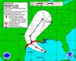
"The bottom line: It continues to move to the east and to the north, with impact along the Brazoria-Matagorda County line," said Walt Zaleski, meteorologist at the National Weather Service's Fort Worth office, late Wednesday. "That doesn't mean it will continue to do that."

But if it does, the Houston-Galveston area would be on what is considered the rougher, "dirty side" of a Category 4 hurricane, bringing with it storm surges of up to 20 feet in some areas.

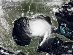
At 10 a.m. today, the storm was 470 miles east-southeast of Galveston, moving at 10 mph on a west-northwesterly track, according to the National Weather Service. Maximum sustained winds were near 100 mph, with higher gusts.

Although it has not strengthened appreciably this morning, Ike has continued to grow in size. Hurricane-force winds were extending 115 miles outward from its center, the weather service reported, and tropical storm-force winds were extending 275 miles out.

"This is a big storm," Zaleski said.

Mandatory evacuations have been called for Brazoria County and areas south of Texas 35 and the Blessing area of Matagorda County.

Mayor White this morning urged residents to use today's good weather to clear their yards and patios of furniture, grills and other items that could become projectiles in hurricane-force winds.

They also should gather all the supplies they would need to ride out the storm if they haven't done so already, he said.

Even though it may appear that the storm's eye is heading toward landfall relatively far from here, Houston-area residents should take the storm seriously, White added.

"The exact location of where the eye crosses the coast may not be as important with a storm this size that has a storm surge this broad and winds this strong along the Texas coast," White said.

Harris County Commissioners Court held an emergency meeting at 10:30 a.m. today to discuss plans to shut down most county operations on Friday. Emmett does not have the authority to make that decision on his own.

Houston-area residents who live near bayous but are not in the ZIP codes under the mandatory evacuation order should use common sense in deciding whether to leave or shelter in place, White said.

"If (during) every storm that's come through here in the last 30 years their house has flooded, then when something is coming down like this, they ought to be thinking about what to do," White said. "But we do not have a mandatory evacuation area for everybody who lives along a particular bayou."

By late Wednesday afternoon, state and county officials, huddled together on a conference call, tried to make sense out of Ike's sudden 50-mile jump to the north and its widening cone. However, Jack Colley, chief of the Governor's Division of Emergency Management, assured city, county and state officials that no area along the coast would be without resources to get residents out.

''We're not going to chase Ike,'' he said. ''We're trying to position, reposition, reorganize."

Since Hurricane Rita in 2005, Colley's network of public officials and private business, particularly those from the grocery and fuel industries, has been tested with several smaller storms and emergencies. The strategy is simple: Once a hurricane or tropical storm is 120 hours away from Texas, a countdown clock begins.

Colley's team begins moving fuel and supplies to areas expected to be hit and then gradually pulling back and supplying the evacuation routes. The idea is that no one wants to see a repeat of the disastrous Hurricane Rita evacuation, in which it took too long to contraflow the highways — routing all traffic away from the storm — and too many Texans evacuated, choking the state's prized highway system and depleting all gas stations for days.

Ike is expected to be the biggest test for Texas since Rita. Despite being in a region already fatigued by the number of storm alerts and near misses, Ike's uncertain path has grabbed the attention of most residents in the Houston-Galveston area.

''I think, with each little ratchet up in our direction, people are going 'That's going to change things,' '' said Emmett.

Some residents debated whether to stay or go.

Bingo Cosby, owner of a surf shop in Surfside Beach, said Wednesday that he planned to ride out the blow. "I'm going to go upstairs above my shop with my two guns and protect my property," he said.

"Besides, the storm isn't coming here," he said confidently. "I went out on the jetty last night and prayed that it would just turn around."

But Darrin Hebert, who lives in Freeport and works for a sandblasting company, said he was getting out of town. "I've never left for a storm before," he said, "but I just got the feeling that this is going to be the bad one."

Hebert hitched a ride to Angleton, where people without their own transportation were boarding buses headed for shelters.

Rush on hurricane supplies
The number of people evacuating is expected to intensify today.

To ease any crush of traffic, the Texas Department of Transportation cleared debris and opened extra lanes for traffic heading away from the coast.

In the event Ike gets mean, 7,500 National Guard troops have been activated and are moving into position, and 1,350 passenger buses are standing by to help evacuations.

Gov. Rick Perry ordered state agencies to continue to gear up for the storm and advised citizens to stay alert.

A rush on hurricane supplies was reported at several coastal-area stores, as shoppers stocked up on batteries, bottled water and plywood to cover windows.

"A lot of people are getting edgy," said Javier Moreno, an assistant store manager at a Home Depot in Corpus Christi.

As trucks pulled in with more wood, passengers were lined up waiting for it, he said.

Nueces County Judge Loyd Neal said there would be no mandatory evacuation, but people should take steps to ensure their safety.

"If you want to get out of harm's way, do it now," Neal said.

Residents were told they would be on their own during the hurricane and neither the Red Cross nor the government would be operating shelters before the storm.

Hundreds leave Corpus
Buses to San Antonio were provided free of charge to all those who could not make it out of town on their own.

Manuel Castellanos, 48, and his girlfriend Grace Garcia, 43, were among the hundreds of Corpus Christi residents who gathered at a downtown senior citizens center to board evacuation buses.

Clutching a white stuffed bear, Castellanos said he and Garcia decided to flee their low-lying home on the city's South Side because "there's no telling what may happen. I don't want to take no chances."

In Chambers County, officials ordered residents to evacuate the flood-prone areas bordering Galveston and Trinity Bay.

"We are expecting a possible 4-foot to 8-foot storm surge that could put some areas underwater," said Ryan Holzaepfel, who heads the county's emergency management.


Contributing to this report were the Associated Press and Chronicle staff writers Dane Schiller in Houston, Richard Stewart in Brazoria County, Cindy Horswell in Chambers County, Rick Dunham in Washington and San Antonio Express-News writer Lisa Sandberg in Corpus Christi.


http://www.chron.com/disp/story.mpl/metropolitan/5993388.html
 

NWPhotog

Veteran Member
Perry warns Texans in Ike's path: Get out now

USTIN — Gov. Rick Perry today urged coastal residents in Hurricane Ike's path to evacuate immediately, describing it as a storm that could swamp houses in Galveston and other areas to at least their eves.

"My message to Texans is, in the projected impact area, finish your preparations because this is a storm that can have extraordinary impact on them, on their personal belongings," Perry said. "It's on its way."

While the storm presently is a Category 2 hurricane, Perry said it could be at Category 4 level by the time it makes landfall on Saturday.

"I want to emphasize what a dangerous storm this is going to be," he said. "The latest estimates show Ike is going to be coming to shore in the next 48 hours, packing winds in excess of 120 mph and a storm surge of 14 feet or more. And I want to emphasize the more."

Jack Colley, chief of the Governor's Division of Emergency Management, described the storm as hitting like a tidal wave.

"This is a surge tsunami," he said. "This is not rising water. This is water that goes beyond rising."

Regardless of whether Ike is at Category 3 or 4 when it crosses the coast, Colley said, much of Galveston Island will be inundated.

He added that the storm has made nine major changes in course, so most of the coast should be prepared for evacuation.

National Weather Service forecaster Walt Zaleski said the storm also may have major impacts in the San Antonio, Austin and Waco areas because of a high potential for tornadoes in its outer bands.

"These are not going to be your typical Texas tornadoes that are half a mile to a mile wide," Zaleski said. "These are going to be small, short-lived, fast-moving, invisible, often shrouded in rainfall."

Zaleski said tropical storm- force winds of 40-50 mph extend 250 miles from the storm's center.

"This is a big storm," he said. "This is one of the biggest storms we've seen in a while, in terms of its girth."

Perry said this morning that 2,650 government officials listened on a conference call to prepare for the storm. He said he has activated 7,500 members of the National Guard.

The governor said there also are 1,300 buses and 100 ambulances helping to evacuate those who cannot do it themselves. Additionally, six C-130 aircraft from the Texas State Guard are participating in the evacuation of Galveston.

Several lessons that have been learned from Hurricane Rita, in September 2005, have resulted in a plan to move gasoline to retailers in evacuation zones, Perry said, and wristbands will be used to help the state keep track of evacuees' location.

Perry also noted that global positioning satellite systems were put on the evacuation buses so that, when Ike changed direction, the buses could be redirected from Corpus Christi to Galveston.

He said Galveston Mayor Lyda Ann Thomas ordered the evacuation of the island after viewing a slide showing projections of the inundation of her city.

"If your house has an eve that's 14 feet, it would be completely under water," Perry said. "That's the type of surge we're talking about all through Galveston and all the way up into the (Houston) Ship Channel."

If a Category 5 storm went up the Ship Channel with no evacuation, Perry said, the estimated death toll would be 1.5 million people.

He stressed that the impact of Ike could also be devastating if people do not follow evacuation orders.

"I cannot over-emphasize the danger that is facing us," he said. "It's going to cause some substantial damage. It's going to knock out power. It's going to cause massive flooding.

"There is a point in time when Mother Nature can overwhelm you with her power, but hopefully, this is not the case."


http://www.chron.com/disp/story.mpl/metropolitan/5995957.html
 

gisgaia

Veteran Member
BRKG: INFO RE NATIONAL GASOLINE SHORTAGE ?!

[Gasoline info on down in bold I added]

CNN on now, saying this storm is NOT going to make a sudden right-hand turn like others have in past. He is showing how the storm is going to make sort of a curve a bit towards downtown Houston as soon as it makes landfall near the area of Angleton (west of Galveston) ... saying that the "bad side" of the storm, the east side (right-hand side) of the eye with 120mph winds is going to be on the Galveston/Houston side of the storm ... that this is very, very bad situation. (He adds all this is based on what is expected - if the current forecast holds true)

Another report CNN --- saying things on I-45 are going into chaos, everyone is suddenly realizing they need to get out of town, people trying to cut into lines, people with many gas cans to fill extra, etc.
===================

Regarding San Antonio-Austin areas, Dallas-Ft Worth, etc ... this is what I've heard so far from TV + some insider friends & relatives working in EMS system around the state:

> When Gov Perry had conf. this morning on KHOU, there was also segment with the Regional Director of the NWS from Fort Worth who is there helping them with managing things (can't recall his name). That man talked of how there will be tornadoes hitting sudden & without warnings in areas like San Antonio all the way up into Dallas as the hurricane bands start moving in on Friday afternoon, way before the eyewall comes on land. Also very high wind gusts and heavy storms in these bands too .... there are special warnings of this here in DFW now on the NWS scanner right now saying for all residents here to immediately prepare!

-------------------------

> On KHOU now is live report saying gas stations in Houston are going dry and huge lines are forming. Showing lines of people like 100+ in stores trying to buy basics.

> In areas off towards beach regions things are completely shutting down - no fast food or gas stations open now ... some areas are empty towns
,,,,,,,

BREAKING KHOU: "Gas is suddenly going up to $4.00/per gallon WHOLESALE price" which will boost retail price likely up to $4.50/gallon (Whuh-oh ... not good timing)

KHOU has switched to a LIVE briefing with officials from Fed Gov't:

FEMA on KHOU now ... it is Chertoff of Homeland Security on live now, he's saying that this storm is serious, not to take it lightly, it is large and powerful, carrying much water in it. And Prez Bush is being briefed on status of preps, blah blah,,, storm has complicated things due to suddenly moving direction in past 24 hours. They are planning:
--Using overhead imagery per UAV's to assess damage before/after
--Bringing in much rescue equipment to stage for immediately afterwards

Next is FEMA Director, saying similar stuff about how they are preparing & staging in advance, to heed evac orders, etc. Having video-conferences with local officials, state gov't.... critical for everyone to follow local authorities. Hurricane force winds may be over much of state of Texas by Saturday afternoon ... could be widespread situations all over. That they are moving in millions of liters of water, millions of MRE's, 100 generators are here and 87 more on the way.

Coast Guard head is now on stage - talking of how they are getting ready and working with other agencies - the usual stuff, closing ports, vessels being put to sea, securing ships, preparing for mass disasters, setting up control-command centers (yes, Houston being a major port & chemical/oil refining region is a huge maritime concern!). Activitating 250 reservists to deploy...

Health - Human Services: They are now helping to evac hospitals & nursing homes throughout region & ongoing. Some facilities are right now being changed from the original plan to "shelter-in-place" to full evacuation and all this happening this afternoon. He is emphasizing to public how any people with special needs need to access the emergency system in their area so to be placed in special shelters being set up and not try to shelter in place.

Another man is on ... he is in a civilian suit (edit: adding - I think he is from the DOE) ... he is talking very fast, low voice + hard to hear: saying ... that many Refineries already are or soon will be being shut down today ... that there will be fuel impacts because of this ... ---- wait ---- he is saying something about how there will be problems and supplies may be replenished when refineries come back on line in Louisiana (HUH ???????? ) ... that crude stock may need to be released from Strategic Reserves ...

[ OK, somebody help me here ... was this man talking about gasoline shortages due to this storm ,,, I never actually heard him say that word out loud but I thinking that is what he was referring to with "refined product" term - yes ? .... Anyone else watching this KHOU live right now ... need help keeping up! ]

---> Chertoff back on with phone question that I missed & his answer: He is saying that this storm is bigger than Katrina ... that Mother Nature is going to win this game.

Phone Q from man @ Dow Jones NewsWire to a Mr Jones (DOE?): "You were saying that fuel is going to be interuppted ... regional or across country and what is timeline? :

(OK - this is the man in suit who spoke about refineries = gasoline: His A --> "I'm talking about refined product ... and the size of this storm and the extent of impact ... it will, it could extend from regional up to East Coast and the mid-Atlantic ... that part of country relies on Gulf of Mexico ... could expect this due to length of pipeline.


{{I cannot type fast enough to capture their exact words - so may not be accurate at all ... if anyone can find a transcript of this we need it posted STAT! }}

Q from Reuters for the DOE "... there were pending requests for oil loans from Gustoff, have you responded to those (SPR loans?) ...
A: suit man, he is talking about their response .. .too fast to keep up ,,, "there have been 2 more requests this afternoon"

--Another question on phone from anon man: re what is DOE man saying about oil/gasoline prices & oil-chemical products?

DOE Man's A: ---> "I will not speak to prices... it will be a 1-2 hit .. the midwest & eastern parts of the country are dependent on piping operations to those parts of the country ... this will depend on damage, delivery pipes damage and refineries damaged, don't know - could be signficant ... speaking of how this happened with Gustav some --- that this storm has the potential to create such problems ,,,

========================

KHOU on now with Fed conference update over,,, talking of how there may be fuel shortages of gasoline & diesel in various parts of the country because of this storm ... discussion between the reporter on this.

I must head out now ... someone that has time can maybe keep updating.

Oh, KHOU showing how IKE is having some dry air inflow into the northwest side of storm and this is weakening it perhaps, pressure is going up some.

(I think there are efforts being made via chemtrails/HAARP or ??? to decrease the power of the storm as this is definitely a threat to U.S. national security if gasoline refining is hampered for lengthy period!)

========================

Texas prepares for an ominous Hurricane Ike
By JUAN A. LOZANO – 54 minutes ago
http://ap.google.com/article/ALeqM5jG1m4XT341oCKXPMIZlKffdhP9vwD934M7VG0

HOUSTON (AP) — Authorities in the Houston area and along the Southeast Texas Gulf Coast ordered hundreds of thousands of people to evacuate Thursday as Hurricane Ike lumbered toward the coast and threatened to grow even stronger.

Traffic was building on roadways leading away from low-lying areas in Galveston County, and officials urged residents to finish storm preparations quickly. Some gas stations were running out of fuel as residents scurried to leave.

"It's a big storm. I cannot overemphasize the danger that is facing us," Gov. Rick Perry said at a news conference. "It's going to do some substantial damage. It's going to knock out power. It's going to cause massive flooding."

Forecasters issued a hurricane warning for the Texas Gulf Coast from the Louisiana state line to near Corpus Christi. The warning, which also extended east along much of the Louisiana coast to Morgan City, means hurricane conditions could reach the coast by late Friday with the front edge of the storm before its powerful center hits land over the weekend.

In Houston, gleaming skyscrapers, the nation's biggest refinery and NASA's Johnson Space Center lie in areas that could be vulnerable to wind and floodwaters if Ike crashes ashore as a major hurricane.

Ike is expected to become at least a Category 3 storm, with winds upward of 111 mph, before it comes ashore, the National Hurricane Center in Miami said. Some forecasts indicate Ike could grow to a Category 4, with winds of at least 131 mph. Emergency officials warned it could drive a storm surge as high as 18 feet.

If current projections of the storm's path hold up, the area surrounding Houston — home to about 4 million people — would be lashed by the eastern or "dirty" side of the storm, said meteorologist Jeff Masters, co-founder of San Francisco-based Weather Underground. This stronger side often has punishing rains, walloping storm surge and tornadoes.

Authorities were hoping to avoid the traffic gridlock of three years ago, when Hurricane Rita threatened the area, and urged people who don't live in eight specific zip codes in the low-lying areas and near Galveston Bay to remain at home.

"We are still saying: Please shelter in place, or to use the Texas expression, hunker down," said Harris County Judge Ed Emmett, the county's chief administrator. "For the vast majority of people who live in our area, stay where you are. The winds will blow and they'll howl and we'll get a lot of rain but if you lose power and need to leave, you can do that later."

Evacuation orders were also issued for all of Jefferson and Orange counties, an area home to more than 320,000 people between Houston and the Louisiana state line, and part of San Patricio County farther south.

In Tierra Grande, a low-lying rural neighborhood, or colonia, south of Corpus Christi, residents struggled with the cost of evacuation and the strong pull to stay with their homes and animals. Few, if any, appeared to be leaving.

Diana Acevedo said she and her family considered leaving their double-wide trailer, but they had called around and it was too late to find a place to stay. Looking out at a rickety swingset and tricycle in the front yard, Acevedo said they would pick up loose items today and perhaps board windows like some of her neighbors.

"I think it's going to get really bad," she said. In previous heavy rains, water filled with sewage from flooded septic tanks has lapped near her door, more than two feet off the ground.

Galveston Mayor Lyda Ann Thomas extended a mandatory evacuation that had covered the west side of the island, unprotected by a seawall, to the entire island.

She said the city, virtually destroyed by a hurricane in 1900 that killed more than 6,000 people and remains the nation's worst natural disaster, will not open shelters. She advised those who chose to ignore the order to have supplies like food, water and medicine and secure their homes.

"This is a very hard call for me to make but our intent is to save lives," she said. "We believe it is best for people to leave."

In Louisiana, where Labor Day's Hurricane Gustav was blamed for 29 deaths, officials closed flood gates and state offices along the coast.

"Today would be a good time for folks to fuel up their cars, just to make sure they have sufficient supplies," Gov. Bobby Jindal said, adding the state corrections department had evacuated about 1,400 prisoners from Cameron and Calcasieu parishes in the state's southwest.

Ike was a Category 2 storm as of 2 p.m. EDT Thursday with top sustained winds near 100 mph, the National Hurricane Center said. It was over the Gulf's energizing warm waters about 440 miles east-southeast of Corpus Christi and moving west-northwest near 10 mph after ravaging homes in Cuba and killing dozens of people in the Caribbean.

The Port of Houston, the nation's second largest port, planned to shut down operations Thursday afternoon and remain closed until Monday.

The oil and gas industry also watched the storm closely, fearing damage to the very heart of its operations.

Refineries on the upper Texas coast account for one-fifth of U.S. refining capacity. Exxon Mobil Corp.'s plant in Baytown, outside Houston, is the nation's largest refinery. Exxon Mobil, Valero Energy Corp., ConocoPhillips and Marathon Oil Co. were among the companies halting operations as the storm closed in.

Refineries are built to withstand high winds, but flooding can disrupt operations and — as happened in Louisiana after Hurricane Gustav — power outages can shut down equipment for days or weeks.

Supply concerns sent wholesale gasoline prices soaring to record levels between $4 and $5 a gallon Thursday. That means retailers will pay more for gasoline, and consumers can expect hikes at the pump. How much gas prices rise, analysts say, depends largely on how long refineries remain shuttered after the storm passes.

Dow Chemical Co. was shutting down its enormous Freeport facility, home to 75 plants producing some 27 billion pounds of chemical or chemical products each year, and its 139-acre LaPorte site, said Dow spokesman David Winder.

Associated Press writers Melinda Deslatte in Baton Rouge, Michael Graczyk in Houston, John Porretto in Houston, Monica Rhor in Houston, Kelley Shannon in Dallas, Michelle Roberts in San Antonio and Christopher Sherman in Corpus Christi contributed to this report.
////////// END
 
Last edited:

NWPhotog

Veteran Member
Chambers County scrambles for evacuation buses after companies renege

Chambers County Judge Jimmy Sylvia said today he is searching for buses to relocate about 170 residents from the county's two nursing homes after bus companies reneged on contracts to do the job.

Sylvia, who issued a mandatory evacuation order for the county today, said he has put in a request for buses from state emergency officials but not had a reply yet.

He did not identify the bus companies.

"I have no idea what will happen. I made the request and that's all I can do," he said. "The state's in a tough spot because they had all that staging to the south and now it's moving our way."

He compared this hurricane to Rita that forced evacuations across almost the entire Texas coast and then struck near Chambers County on the border between Texas and Louisiana.

He said some of the nursing home residents are too ill to be moved by bus and would have to use ambulances.

If no buses are found, he said the nursing home residents might have to "hunker down where they are" at Anahuac Healthcare in Anahuac and the Arboretum in Winnie.

He said the hospital in Anahuac plans to remain open during the storm, and the county's jail population also is not going to be relocated.

County officials at first had recommended evacuating only low-lying areas such as Smith Point, Oak Island and two subdivisions in Beach City.

But officials changed their minds when they learned the storm surge was now projected to be 20 to 25 feet instead of 4 to 8 feet.

He said some of the homes in Smith Point are only 2 1/2 feet above sea level, for example, and could be completely submerged under 17 or more feet water.

http://www.chron.com/disp/story.mpl/front/5995802.html
 

BlueNewton

Veteran Member
"HURRICANE IKE LOCAL STATEMENT
NATIONAL WEATHER SERVICE HOUSTON/GALVESTON TX
120 PM CDT THU SEP 11 2008...

....LIFE THREATENING INUNDATION LIKELY!

ALL NEIGHBORHOODS...AND POSSIBLY ENTIRE COASTAL COMMUNITIES...
WILL BE INUNDATED DURING HIGH TIDE. PERSONS NOT HEEDING
EVACUATION ORDERS IN SINGLE FAMILY ONE OR TWO STORY HOMES WILL
FACE CERTAIN DEATH. MANY RESIDENCES OF AVERAGE CONSTRUCTION
DIRECTLY ON THE COAST WILL BE DESTROYED. WIDESPREAD AND
DEVASTATING PERSONAL PROPERTY DAMAGE IS LIKELY ELSEWHERE. VEHICLES
LEFT BEHIND WILL LIKELY BE SWEPT AWAY. NUMEROUS ROADS WILL BE
SWAMPED...SOME MAY BE WASHED AWAY BY THE WATER. ENTIRE FLOOD PRONE
COASTAL COMMUNITIES WILL BE CUTOFF. WATER LEVELS MAY EXCEED 9 FEET
FOR MORE THAN A MILE INLAND. COASTAL RESIDENTS IN MULTI-STORY
FACILITIES RISK BEING CUTOFF. CONDITIONS WILL BE WORSENED BY
BATTERING WAVES. SUCH WAVES WILL EXACERBATE PROPERTY DAMAGE...WITH
MASSIVE DESTRUCTION OF HOMES...INCLUDING THOSE OF BLOCK
CONSTRUCTION. DAMAGE FROM BEACH EROSION COULD TAKE YEARS TO
REPAIR."

http://www.srh.noaa.gov/wwamap/wwatxtget....

This is THE most terrifying weather warning I have ever soon. Unbelievable.

Sassy, I hate to be critical but all those things you have to get done, except for topping off the gas tanks--they are basic prep items and should have already been done by now!! Yikes! We have to do better than that! Sorry. That just concerns me. Be safe.
 

BlueNewton

Veteran Member
"Diana Acevedo said she and her family considered leaving their double-wide trailer, but they had called around and it was too late to find a place to stay. Looking out at a rickety swingset and tricycle in the front yard, Acevedo said they would pick up loose items today and perhaps board windows like some of her neighbors."

She is staying in a trailer and will MAYBE board her windows? She has NO idea.... Well, I suppose if the trailer is gone, she won't have wasted time boarding the windows if she just blows it off. This woman has clearly never experienced and major hurricane. :whistle:
 

Rubythedane

Contributing Member
Those nursing homes in the article are at a real risk

If no buses are found, he said the nursing home residents might have to "hunker down where they are" at Anahuac Healthcare in Anahuac and the Arboretum in Winnie.

BAD NEWS those nursing homes are way too close to the coast to "hunker down". I hope we don't see a repeat of what happened with that New Orleans area nursing home that flooded.
 

The Traveler

Veteran Member
This is THE most terrifying weather warning I have ever soon. Unbelievable.

Sassy, I hate to be critical but all those things you have to get done, except for topping off the gas tanks--they are basic prep items and should have already been done by now!! Yikes! We have to do better than that! Sorry. That just concerns me. Be safe.

+1. I have lived near the coast in the Houston Metro most of my life, and have followed storms since I was a kid. I have never seen that before and it gave me chills. I pray all that need to leave will go and the ones that stay stay safe.
 

gisgaia

Veteran Member
Last update from me for this time as must go run must-do errands:

KHOU is saying that some of the roads running right along coastal areas are now becoming flooded as the water is rising along the shoreline regions... that the road called "Blue Highway" going between Surfside & Galveston is now closed and is underwater.

They are saying that there will be tropical-force winds hitting coastal areas and into Houston by tomorrow after lunch and that cars will be blown off bridges like the one connecting Galveston to mainland ... so not much time left to evacuate if you are in a dangerous (life or death!) SURGE area or a high-risk person with special needs (medical) that should not try to hunker down from the winds, etc.

Another item they have repeated in past hour is that areas further north, like even Friendswood & Pearland, could have some surge flooding + very dangerous winds sustained over 100 mph for several hours with the current forecast of landfall as it is. That if the storm jogs just even a little bit to the east, then things will even be worse for all areas south of Houston running along I-45.

Also, reporters now talking of how Houston & region airports are going to be shutting down by morning Friday and that chaos is starting to occur in all sorts of unexpected ways as people begin trying to get out any way they can or obtain essential prep supplies at the last minute.

From what I'm gathering, many other city areas like San Antonio & Dallas are making plans for disasters and cancelling big events, etc. Just had a phone call from local in Dallas that gas stations there are running dry as the people coming in from areas south are lining up to refuel and that many have not made plans on where to stay and just floundering about as they try to figure out which direction to head!
 

Jarhead

Has No Life - Lives on TB
000
WTNT34 KNHC 112047
TCPAT4
BULLETIN
HURRICANE IKE ADVISORY NUMBER 43
NWS TPC/NATIONAL HURRICANE CENTER MIAMI FL AL092008
400 PM CDT THU SEP 11 2008

...IKE HEADED FOR THE NORTHWESTERN GULF OF MEXICO...

A HURRICANE WARNING IS IN EFFECT FROM MORGAN CITY LOUISIANA TO
BAFFIN BAY TEXAS. HURRICANE CONDITIONS COULD REACH THE COAST WITHIN
THE WARNING AREA BY LATE FRIDAY.

A TROPICAL STORM WARNING AND A HURRICANE WATCH ARE IN EFFECT FROM
SOUTH OF BAFFIN BAY TO PORT MANSFIELD TEXAS.

A TROPICAL STORM WARNING IS IN EFFECT FROM EAST OF MORGAN CITY
TO THE MISSISSIPPI-ALABAMA BORDER...INCLUDING THE CITY OF NEW
ORLEANS AND LAKE PONTCHARTRAIN.

FOR STORM INFORMATION SPECIFIC TO YOUR AREA...INCLUDING POSSIBLE
INLAND WATCHES AND WARNINGS...PLEASE MONITOR PRODUCTS ISSUED
BY YOUR LOCAL WEATHER OFFICE.

AT 400 PM CDT...2100Z...THE CENTER OF HURRICANE IKE WAS LOCATED NEAR
LATITUDE 26.0 NORTH...LONGITUDE 89.4 WEST OR ABOUT 510 MILES...820
KM...EAST-SOUTHEAST OF CORPUS CHRISTI TEXAS AND ABOUT 400 MILES...
645 KM...EAST-SOUTHEAST OF GALVESTON TEXAS.

IKE IS MOVING TOWARD THE WEST-NORTHWEST NEAR 10 MPH...17 KM/HR...AND
THIS MOTION IS EXPECTED TO CONTINUE FOR THE NEXT 24 HOURS...WITH A
TURN TO THE NORTHWEST EXPECTED LATE FRIDAY. ON THE FORECAST
TRACK...THE CENTER OF IKE WILL BE VERY NEAR THE UPPER-TEXAS COAST
BY LATE FRIDAY. HOWEVER...BECAUSE IKE IS A VERY LARGE TROPICAL
CYCLONE...WEATHER WILL DETERIORATE ALONG THE COASTLINE LONG BEFORE
THE CENTER REACHES THE COAST.

MAXIMUM SUSTAINED WINDS ARE NEAR 100 MPH...160 KM/HR...WITH HIGHER
GUSTS. IKE IS A CATEGORY TWO HURRICANE ON THE SAFFIR-SIMPSON SCALE.
IKE IS FORECAST TO BECOME A MAJOR HURRICANE PRIOR TO REACHING THE
COASTLINE.

HURRICANE FORCE WINDS EXTEND OUTWARD UP TO 115 MILES...185 KM...FROM
THE CENTER...AND TROPICAL STORM FORCE WINDS EXTEND OUTWARD UP TO 275
MILES...445 KM.

THE LATEST MINIMUM CENTRAL PRESSURE ESTIMATED FROM AIRCRAFT
RECONNAISSANCE DATA WAS 950 MB...28.05 INCHES.

COASTAL STORM SURGE FLOODING OF UP TO 20 FT ABOVE NORMAL TIDE
LEVELS...ALONG WITH LARGE AND DANGEROUS BATTERING WAVES...CAN BE
EXPECTED NEAR AND TO THE EAST OF WHERE THE CENTER OF IKE MAKES
LANDFALL...EXCEPT AT THE HEADS OF BAYS...WHERE SURGE FLOODING OF UP
TO 25 FT COULD OCCUR. COASTAL STORM SURGE FLOODING OF 6 TO 8 FEET
ABOVE NORMAL TIDE LEVELS...ALONG WITH LARGE AND DANGEROUS
WAVES...CAN BE EXPECTED WITHIN THE TROPICAL STORM WARNING AREA
ALONG THE NORTHERN GULF COAST. ABOVE NORMAL TIDES IN THE EASTERN
GULF OF MEXICO SHOULD GRADUALLY SUBSIDE OVER THE NEXT DAY OR SO.

IKE IS EXPECTED TO PRODUCE RAINFALL AMOUNTS OF 5 TO 10 INCHES ALONG
THE MIDDLE AND UPPER TEXAS COAST AND OVER PORTIONS OF SOUTHWESTERN
LOUISIANA...WITH ISOLATED MAXIMUM AMOUNTS OF 15 INCHES POSSIBLE.

REPEATING THE 400 PM CDT POSITION...26.0 N...89.4 W. MOVEMENT
TOWARD...WEST-NORTHWEST NEAR 10 MPH. MAXIMUM SUSTAINED WINDS...100
MPH. MINIMUM CENTRAL PRESSURE...950 MB.

AN INTERMEDIATE ADVISORY WILL BE ISSUED BY THE NATIONAL HURRICANE
CENTER AT 700 PM CDT FOLLOWED BY THE NEXT COMPLETE ADVISORY AT 1000
PM CDT.

$$
FORECASTER FRANKLIN
 

Jarhead

Has No Life - Lives on TB
000
WTNT44 KNHC 112051
TCDAT4
HURRICANE IKE DISCUSSION NUMBER 43
NWS TPC/NATIONAL HURRICANE CENTER MIAMI FL AL092008
500 PM EDT THU SEP 11 2008

A PAIR OF DROPSONDES THIS AFTERNOON IN THE SOUTHEASTERN QUADRANT
FINALLY PROVIDED SOME HARD DATA TO SUPPORT THE ADVISORY
INTENSITY...WITH LOWER-LAYER MEAN WINDS OF 96 KT...WHICH ADJUST TO
80 KT AT THE SURFACE. AIRCRAFT DATA INDICATE THAT THE SMALL INNER
WIND MAXIMUM HAS ALL BUT DISSIPATED...AND THE INNERMOST RADIUS OF
MAXIMUM WINDS IS NOW AROUND 60 NMI. FLIGHT LEVEL WINDS WINDS THERE
ARE ABOUT 100 KT...AND NEARLY THAT STRONG OUT TO AT LEAST 100 NMI.
AS THE INNER WIND MAXIMUM DISSIPATED...THE MINIMUM PRESSURE ROSE TO
ABOUT 954 MB...BUT HAS SINCE FALLEN TO 950 MB.

THE INTENSITY GUIDANCE HAS COME DOWN SINCE THIS MORNING...ALTHOUGH
THE GFDL STILL MAKES IKE A MAJOR HURRICANE. FACTORS INHIBITING
DEVELOPMENT INCLUDE THE LARGE BROAD WIND FIELD...STRONG WINDS OVER
AREAS OF LIMITED OCEAN HEAT CONTENT ALONG AND NORTH OF THE PATH OF
IKE...AND AN UPPER-LEVEL RIDGE OVER TEXAS THAT IS FORCING DESCENT
AND CREATING DRY AIR AHEAD OF THE PATH OF THE HURRICANE. INDEED...
CONVECTION ON THE WEST SIDE OF IKE HAS BEEN RATHER THIN FOR MUCH OF
THE DAY. HOWEVER...THIS LATTER UPPER FEATURE IS FORECAST TO SLIDE
NORTHEASTWARD AS IKE ENTERS THE NORTHWESTERN GULF...AND IN THIS
CONFIGURATION WOULD PROVIDE AN UPPER PATTERN MORE CONDUCIVE TO
STRENGTHENING RIGHT BEFORE LANDFALL. CURRENTLY THE OUTFLOW IS VERY
WELL ESTABLISHED TO THE NORTHEAST AND SOUTHWEST OF THE CENTER. THE
OFFICIAL FORECAST IS UNCHANGED FROM THE PREVIOUS ADVISORY AND IS IN
BEST AGREEMENT WITH THE GFDL GUIDANCE.

IKE IS MOVING WEST-NORTHWESTWARD AROUND THE PERIPHERY OF A RIDGE OF
HIGH PRESSURE EXTENDING FROM THE WESTERN ATLANTIC WESTWARD OVER THE
SOUTHEASTERN UNITED STATES. A DEEP LAYER TROUGH CURRENTLY EXTENDS
INTO THE SOUTHWESTERN STATES...AND IKE IS EXPECTED TO GENTLY RECURVE
BETWEEN THESE TWO FEATURES IN 48-72 HOURS. THE OBJECTIVE GUIDANCE
HAS SHIFTED SLIGHTLY TO THE RIGHT...AND IS RATHER TIGHTLY CLUSTERED
THROUGH LANDFALL. AS THE UPPER HIGH OVER TEXAS MOVES
NORTHEASTWARD...A SLIGHT BEND OF THE TRACK TO THE LEFT IS EXPECTED
PRIOR TO THE BEGINNING OF RECURVATURE. THE OFFICIAL FORECAST HAS
BEEN NUDGED SLIGHTLY TO THE RIGHT...BUT IS STILL JUST LEFT OF THE
MODEL CONSENSUS. IT IS WORTH NOTING THAT THE AVERAGE 36-HOUR
OFFICIAL FORECAST ERROR IS ABOUT 80 NMI.

BECAUSE OF THE VERY LARGE EXPANSE OF HURRICANE FORCE WINDS...IKE
WILL CREATE A STORM SURGE WELL IN EXCESS OF WHAT WOULD NORMALLY BE
ASSOCIATED WITH A STORM OF ITS INTENSITY.


FORECAST POSITIONS AND MAX WINDS

INITIAL 11/2100Z 26.0N 89.4W 85 KT
12HR VT 12/0600Z 26.6N 90.9W 90 KT
24HR VT 12/1800Z 27.6N 93.0W 95 KT
36HR VT 13/0600Z 29.0N 95.0W 105 KT
48HR VT 13/1800Z 31.5N 95.5W 65 KT...INLAND
72HR VT 14/1800Z 37.0N 90.5W 30 KT...INLAND
96HR VT 15/1800Z...ABSORBED IN FRONTAL ZONE

$$
FORECASTER FRANKLIN
 

Attachments

  • 1.jpg
    1.jpg
    57.9 KB · Views: 89
Status
Not open for further replies.
Top