WEATHER Hurricane Ike Daily Thread for Thursday/ 9-11-08

Status
Not open for further replies.
:eek:
Those wind forecasts are skeerin' me a bit! I'm 86 miles inland, distance from my driveway to Stewart beach. School dist is open today yet several dist north of us are closed, go figure. Even Huntsville and Shepherd school's closed.
This sucks, we just put a new roof on the house in June and Hubby built a new storage shed, just finished last weekend. :boohoo:
Rita downed several of the trees here, none hit the house, but we were on the clean side!!
 

BlueNewton

Veteran Member
Sassy,

I feel your pain. I have family on the west end of Galveston Island. And I actually experienced Alicia there in 1983. That is not something I would easily forget. My car was dumped into the swimming pool. Hunker down!!
 

Jarhead

Has No Life - Lives on TB
Coastal Watches/Warnings and 3-Day Track Forecast Cone
 

Attachments

  • 1.jpg
    1.jpg
    49.3 KB · Views: 245

Jarhead

Has No Life - Lives on TB
Houston-Galveston Could Face Major Damage From Ike
Thursday, September 11, 2008
A/P


HOUSTON — Gleaming skyscrapers, the nation's biggest refinery and NASA's Johnson Space Center lie in areas that could be vulnerable to wind and damaging floodwaters if Hurricane Ike crashes ashore as a major hurricane.

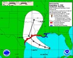
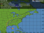
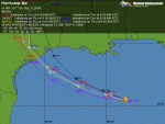
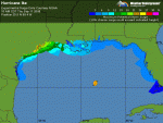
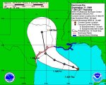
Forecasters expect the storm to make landfall this weekend somewhere between Corpus Christi and Houston, creating the potential for heavy punishment for Houston even if it's not hit directly.

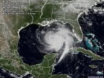
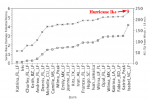
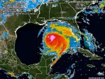
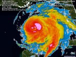
Some forecasts say Ike could strengthen to a fearsome Category 4 hurricane with winds of at least 131 mph over the Gulf of Mexico, and emergency officials warned it could drive a storm surge as high as 18 feet.

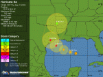
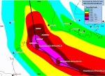
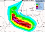
If current projections of the storm's path hold up, the area surrounding Houston — home to about 4 million people — would be lashed by the eastern or "dirty" side of the storm, said meteorologist Jeff Masters, co-founder of San Francisco-based Weather Underground. This stronger side of the storm often packs heavy rains, walloping storm surge and tornadoes.

"I expect a lot of damage in Houston from this storm," said Masters, adding that Ike could cause a "huge storm surge" affecting at least 100 miles of the Texas coast.

Houston officials were expecting some flooding, the question is how much.

Patrick Trahan, spokesman for the city of Houston, told The Associated Press early Thursday that "based on the current forecast (we) would expect to see some flooding based solely on the surge in some low-lying areas."

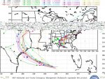
Four counties south and east of Houston have announced mandatory or voluntary evacuations, and authorities began moving weak and chronically ill patients by bus to San Antonio, about 190 miles from Houston. About 1 million people live in the coastal counties between Corpus Christi and Galveston.

But no immediate evacuations were ordered in Harris County, which includes Houston.

The Galveston-Houston area could be on the edge of hurricane-force wind gusts, even if the storm makes land 100 miles to the southwest as some forecasts say is likely, said forecaster Joe Bartosik. Storm surges in the Houston-Galveston area could reach 10 to 14 feet in a Category 3 storm, and as much as 20 feet for a Category 4, said Bartosik, senior meteorologist with WeatherBug, a private weather company with 1,500 weather stations along the Gulf Coast.

The surge in Galveston Bay could push floodwaters into Houston, damaging areas that include the nation's biggest refinery and NASA's Johnson Space Center.

Diana Rangel, a lifelong resident of Freeport, which is under a mandatory evacuation order in Brazoria County, said it is better that she, her family and other residents on the Texas coast, leave.

"We don't want to get stuck out here (in flood waters)," she said Wednesday as she filled her car with gasoline at a convenience store in Freeport overrun with other vehicles waiting in line to fill up.

The oil and gas industry also watched the storm closely, fearing damage to the very heart of its operations.

Texas is home to 26 refineries that account for one-fourth of U.S. refining capacity, and most are clustered along the Gulf Coast in such places as Houston, Port Arthur and Corpus Christi. Exxon Mobil Corp.'s plant in Baytown, outside Houston, is the nation's largest refinery. Dow Chemical has a huge operation just north of Corpus Christi.

Refineries are built to withstand high winds, but flooding can disrupt operations and — as happened in Louisiana after Hurricane Gustav — power outages can shut down equipment for days or weeks. An extended shutdown could lead to higher gasoline prices.

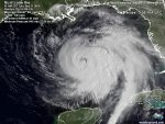
At 2 a.m. EDT, Ike was a Category 2 storm with winds near 100 mph. It was about 645 miles east of Brownsville, Texas, and was moving west-northwest near 9 mph, after ravaging homes in Cuba and killing dozens of people in the Caribbean.

http://www.foxnews.com/story/0,2933,420783,00.html
 

Jarhead

Has No Life - Lives on TB
William

I'll see your "like" and raise you a "hike"..... :)
.
 

Attachments

  • 1.jpg
    1.jpg
    45.9 KB · Views: 201

Jarhead

Has No Life - Lives on TB
This is insanity.....

From CNN....

"In Galveston, city officials ordered mandatory evacuations for part of the island town beginning at 7 a.m. CT (8 a.m. ET) Thursday. The rest of the town will be under a voluntary evacuation order. Only residents will be required to evacuate on the western end of the island.

Mayor Lyda Ann Thomas defended this decision, saying current models call for Galveston to be hit with winds and rain only equivalent to a Category 1 hurricane.

"We do not intend to evacuate Galveston Island," she said. "It's the last thing we want to do. Our job is to protect lives and property, [and] right now we feel that sheltering in place is the best action for our citizens to take."

Anyone have an update???

Jarhead
:usm:

Link...http://www.cnn.com/2008/US/weather/09/11/hurricane.ike.texas/index.html
 

Anjou

Inactive
This is insanity.....

"We do not intend to evacuate Galveston Island," she said. "It's the last thing we want to do. Our job is to protect lives and property, [and] right now we feel that sheltering in place is the best action for our citizens to take."

Too high now, too much uncertainty, too little time to get folks off the island if they decide later.
 
Our local news said they WERE evacuating Galveston Island, and Houston had to wait until the Galveston people were out and safe BEFORE they could leave.

I have family in Pearland (So of Houston) which I hope are headed this way.
 
The west end of Galveston has no protection whatsoever. The wall built for protection (which is not now as high as it used to be) stops short of the west end. There are houses directly on the beach on west end. In the city the houses are across the wall and across the street, much higher and off the beach.

I spent a few weeks on West Galveston Beach a few years back. It's going to be destroyed.
 

BlueNewton

Veteran Member
The Galveston Seawall was once a very high solid wall offering rather good protection from storms. Over time, the tides have displaced sand around the island (a sand bar, really) so that the beach in front of most of the wall is now gone and the sand level (under water) is now about 8 to 15 feet higher than it once was. The Seawall is, in effect, no longer a wall at all. Those behind it in most locations now have no protection, just like those further west on the beach, itself.

Alicia had sustained winds of 115 miles per hour. Imagine that the day before, when we went out to fill up the cars, my poor dog could not cross the Seawall street due to winds blowing so hard. She was like a kite on her leash, practically. Our legs in shorts were streaked with red from the flying sand. It was like being sand blasted. Remember, this was the day BEFORE it hit. Afterwards, traffic lights on the Seawall, itself, which were on the sidewalk, were no longer facing traffic in some places but had been bent/rotated by the wind and faced away from the water from where the wind had been blowing. Traffic light posts on Broadway, the other main east-west road through town, reach out over the traffic. They had been bent down and touched the ground in some places. One road up to the Seawall had completely collapsed in a pit.

Last I heard, Ike had sustained winds of 127 per hour.
 

Jarhead

Has No Life - Lives on TB
000
WTNT34 KNHC 111449
TCPAT4
BULLETIN
HURRICANE IKE ADVISORY NUMBER 42
NWS TPC/NATIONAL HURRICANE CENTER MIAMI FL AL092008
1000 AM CDT THU SEP 11 2008

...IKE CONTINUES TO GROW IN SIZE BUT HAS NOT STRENGTHENED YET...
...HURRICANE WARNING ISSUED FOR NORTHWESTERN GULF COAST...

AT 10 AM CDT...1500 UTC...A HURRICANE WARNING HAS BEEN ISSUED FROM
MORGAN CITY LOUISIANA TO BAFFIN BAY TEXAS. HURRICANE CONDITIONS
COULD REACH THE COAST WITHIN THE WARNING AREA BY LATE FRIDAY.

AT 10 AM CDT...A TROPICAL STORM WARNING HAS BEEN ISSUED FROM SOUTH
OF BAFFIN BAY TO PORT MANSFIELD TEXAS. A HURRICANE WATCH REMAINS
IN EFFECT FOR THIS AREA.

A TROPICAL STORM WARNING REMAINS IN EFFECT FROM EAST OF MORGAN CITY
TO THE MISSISSIPPI-ALABAMA BORDER...INCLUDING THE CITY OF NEW
ORLEANS AND LAKE PONTCHARTRAIN.

FOR STORM INFORMATION SPECIFIC TO YOUR AREA...INCLUDING POSSIBLE
INLAND WATCHES AND WARNINGS...PLEASE MONITOR PRODUCTS ISSUED
BY YOUR LOCAL WEATHER OFFICE.

AT 1000 AM CDT...1500Z...THE CENTER OF HURRICANE IKE WAS LOCATED
NEAR LATITUDE 25.5 NORTH...LONGITUDE 88.4 WEST OR ABOUT 580 MILES...
930 KM...EAST-SOUTHEAST OF CORPUS CHRISTI TEXAS AND ABOUT 470 MILES
...760 KM...EAST-SOUTHEAST OF GALVESTON TEXAS.

IKE IS MOVING TOWARD THE WEST-NORTHWEST NEAR 10 MPH...17 KM/HR. A
GENERAL WEST-NORTHWESTWARD MOTION IS EXPECTED OVER THE NEXT DAY OR
SO...AND THE CENTER OF IKE SHOULD BE VERY NEAR THE COAST BY LATE
FRIDAY. HOWEVER...BECAUSE IKE IS A VERY LARGE TROPICAL
CYCLONE...WEATHER WILL DETERIORATE ALONG THE COASTLINE LONG BEFORE
THE CENTER REACHES THE COAST.

MAXIMUM SUSTAINED WINDS ARE NEAR 100 MPH...160 KM/HR...WITH HIGHER
GUSTS. IKE IS A CATEGORY TWO HURRICANE ON THE SAFFIR-SIMPSON SCALE.
IKE IS FORECAST TO BECOME A MAJOR HURRICANE PRIOR TO REACHING THE
COASTLINE.

IKE REMAINS A VERY LARGE TROPICAL CYCLONE. HURRICANE FORCE WINDS
EXTEND OUTWARD UP TO 115 MILES...185 KM...FROM THE CENTER...AND
TROPICAL STORM FORCE WINDS EXTEND OUTWARD UP TO 275 MILES...445 KM.

THE LATEST MINIMUM CENTRAL PRESSURE REPORTED BY A NOAA HURRICANE
HUNTER AIRCRAFT WAS 945 MB...27.91 INCHES.

COASTAL STORM SURGE FLOODING OF UP TO 20 FT ABOVE NORMAL TIDE
LEVELS...ALONG WITH LARGE AND DANGEROUS BATTERING WAVES...CAN BE
EXPECTED NEAR AND TO THE EAST OF WHERE THE CENTER OF IKE MAKES
LANDFALL. COASTAL STORM SURGE FLOODING OF 5 TO 7 FEET ABOVE NORMAL
TIDE LEVELS...ALONG WITH LARGE AND DANGEROUS WAVES...CAN BE
EXPECTED WITHIN THE TROPICAL STORM WARNING AREA ALONG THE NORTHERN
GULF COAST. ABOVE NORMAL TIDES IN THE EASTERN GULF OF MEXICO SHOULD
GRADUALLY SUBSIDE OVER THE NEXT DAY OR SO.

IKE IS EXPECTED TO PRODUCE RAINFALL AMOUNTS OF 5 TO 10 INCHES ALONG
THE CENTRAL AND UPPER TEXAS COAST AND OVER PORTIONS OF SOUTHWESTERN
LOUISIANA...WITH ISOLATED MAXIMUM AMOUNTS OF 15 INCHES POSSIBLE.
RAINFALL AMOUNTS OF 1 TO 2 INCHES ARE POSSIBLE OVER PORTIONS OF THE
YUCATAN PENINSULA.

REPEATING THE 1000 AM CDT POSITION...25.5 N...88.4 W. MOVEMENT
TOWARD...WEST-NORTHWEST NEAR 10 MPH. MAXIMUM SUSTAINED WINDS...100
MPH. MINIMUM CENTRAL PRESSURE...945 MB.

AN INTERMEDIATE ADVISORY WILL BE ISSUED BY THE NATIONAL HURRICANE
CENTER AT 100 PM CDT FOLLOWED BY THE NEXT COMPLETE ADVISORY AT 400
PM CDT.

$$
FORECASTER FRANKLIN
 

Jarhead

Has No Life - Lives on TB
000
WTNT44 KNHC 111506
TCDAT4
HURRICANE IKE DISCUSSION NUMBER 42
NWS TPC/NATIONAL HURRICANE CENTER MIAMI FL AL092008
1100 AM EDT THU SEP 11 2008

DATA FROM AIR FORCE AND NOAA AIRCRAFT INDICATE THAT IKE IS
MAINTAINING AN ATYPICAL WIND STRUCTURE...CHARACTERIZED BY A VERY
BROAD WIND FIELD WITH MULTIPLE WIND MAXIMA AND RELATIVELY LITTLE
TRANSPORT OF WINDS ALOFT DOWN TO THE SURFACE. THE NOAA AIRCRAFT
REPORTED MAXIMUM FLIGHT-LEVEL WINDS OF 103 KT 100 NMI
NORTH-NORTHEAST OF THE CENTER...BUT SFMR AND DROPSONDE DATA
INDICATE THAT THE SURFACE WINDS IN THAT AREA WERE ONLY AROUND 65
KT. IN FACT...THERE HAS BEEN NOTHING AT THE SURFACE RECENTLY THAT
QUITE SUPPORTS THE CURRENT 85 KT ADVISORY INTENSITY.

FORECASTING CHANGES IN THE WIND STRUCTURE OF TROPICAL CYCLONES IS
EVEN MORE CHALLENGING THAN FORECASTING THE INTENSITY...BUT IKE HAS
PLENTY OF TIME FOR ONE OF THE OUTER MAXIMA TO CONTRACT AND FOR THE
WINDS TO TRY TO CATCH UP TO THE CENTRAL PRESSURE...CURRENTLY ABOUT
945 MB. ALTHOUGH OUTFLOW CONTINUES TO BE RESTRICTED TO THE
NORTHWEST...IT IS STRONG ELSEWHERE AND THE SHEAR IS EXPECTED TO
REMAIN LIGHT. ONE INHIBITING FACTOR COULD BE UPWELLING/MIXING OF
COOLER WATER AHEAD OF THE PATH OF IKE DUE TO THE UNUSUALLY LARGE
EXPANSE OF STRONG WINDS. THE OBJECTIVE GUIDANCE NEAR LANDFALL
RANGES FROM A CATEGORY FOUR FROM THE GFDL TO CATEGORY TWO FROM THE
SHIPS MODEL...ABOUT THE ERROR ONE CAN EXPECT FROM AN OFFICIAL
FORECAST ONE TO TWO DAYS OUT. THE OFFICIAL FORECAST ROUGHLY SPLITS
THE DIFFERENCE BETWEEN THESE GUIDANCE MODELS...AND ANTICIPATES THAT
IKE WILL BE A MAJOR HURRICANE AT LANDFALL.

THE INITIAL MOTION IS 290/9. THERE HAS BEEN LITTLE CHANGE TO THE
TRACK FORECAST THINKING THROUGH LANDFALL...WITH IKE EXPECTED TO
MAINTAIN A WEST-NORTHWESTWARD HEADING UNTIL VERY NEAR
LANDFALL...WHEN IT SHOULD GENTLY TURN TO THE RIGHT AT THE WESTERN
PERIPHERY OF THE SUBTROPICAL RIDGE. THE OFFICIAL FORECAST REMAINS
NEAR THE MODEL CONSENSUS...WITH THE ECMWF ON THE RIGHT AND THE GFS
TO THE LEFT. ONCE AGAIN...GIVEN THE TYPICAL FORECAST ERRORS FOR A
48 HOUR FORECAST...AND THE LARGE SIZE OF THE WIND FIELD...IT IS
IMPORTANT NOT TO FOCUS ON THE EXACT FORECAST TRACK.


FORECAST POSITIONS AND MAX WINDS

INITIAL 11/1500Z 25.5N 88.4W 85 KT
12HR VT 12/0000Z 25.9N 90.0W 90 KT
24HR VT 12/1200Z 26.6N 92.0W 95 KT
36HR VT 13/0000Z 27.8N 94.2W 105 KT
48HR VT 13/1200Z 29.5N 95.9W 100 KT...INLAND
72HR VT 14/1200Z 34.5N 94.0W 35 KT...INLAND
96HR VT 15/1200Z 38.0N 85.0W 25 KT...EXTRATROPICAL
120HR VT 16/1200Z...ABSORBED

$$
FORECASTER FRANKLIN
 

Attachments

  • 1.jpg
    1.jpg
    52.2 KB · Views: 175

Jarhead

Has No Life - Lives on TB
Tracking and Models...
 

Attachments

  • 1.gif
    1.gif
    33.7 KB · Views: 176
  • 2.gif
    2.gif
    38.5 KB · Views: 175
  • 3.gif
    3.gif
    31.8 KB · Views: 173
  • 4.jpg
    4.jpg
    79.3 KB · Views: 175

Jarhead

Has No Life - Lives on TB
000
WTNT24 KNHC 111445
TCMAT4
HURRICANE IKE FORECAST/ADVISORY NUMBER 42
NWS TPC/NATIONAL HURRICANE CENTER MIAMI FL AL092008
1500 UTC THU SEP 11 2008

AT 10 AM CDT...1500 UTC...A HURRICANE WARNING HAS BEEN ISSUED FROM
MORGAN CITY LOUISIANA TO BAFFIN BAY TEXAS. HURRICANE CONDITIONS
COULD REACH THE COAST WITHIN THE WARNING AREA BY LATE FRIDAY.

AT 10 AM CDT...A TROPICAL STORM WARNING HAS BEEN ISSUED FROM SOUTH
OF BAFFIN BAY TO PORT MANSFIELD TEXAS. A HURRICANE WATCH REMAINS
IN EFFECT FOR THIS AREA.

A TROPICAL STORM WARNING REMAINS IN EFFECT FROM EAST OF MORGAN CITY
TO THE MISSISSIPPI-ALABAMA BORDER...INCLUDING THE CITY OF NEW
ORLEANS AND LAKE PONTCHARTRAIN.

HURRICANE CENTER LOCATED NEAR 25.5N 88.4W AT 11/1500Z
POSITION ACCURATE WITHIN 10 NM

PRESENT MOVEMENT TOWARD THE WEST-NORTHWEST OR 290 DEGREES AT 9 KT

ESTIMATED MINIMUM CENTRAL PRESSURE 945 MB
MAX SUSTAINED WINDS 85 KT WITH GUSTS TO 105 KT.
64 KT.......100NE 100SE 30SW 60NW.
50 KT.......150NE 150SE 90SW 140NW.
34 KT.......230NE 240SE 150SW 180NW.
12 FT SEAS..330NE 240SE 240SW 400NW.
WINDS AND SEAS VARY GREATLY IN EACH QUADRANT. RADII IN NAUTICAL
MILES ARE THE LARGEST RADII EXPECTED ANYWHERE IN THAT QUADRANT.

REPEAT...CENTER LOCATED NEAR 25.5N 88.4W AT 11/1500Z
AT 11/1200Z CENTER WAS LOCATED NEAR 25.3N 88.0W

FORECAST VALID 12/0000Z 25.9N 90.0W
MAX WIND 90 KT...GUSTS 110 KT.
64 KT...100NE 100SE 30SW 60NW.
50 KT...150NE 150SE 90SW 140NW.
34 KT...230NE 240SE 150SW 180NW.

FORECAST VALID 12/1200Z 26.6N 92.0W
MAX WIND 95 KT...GUSTS 115 KT.
64 KT...100NE 100SE 50SW 60NW.
50 KT...150NE 150SE 90SW 140NW.
34 KT...230NE 240SE 150SW 180NW.

FORECAST VALID 13/0000Z 27.8N 94.2W
MAX WIND 105 KT...GUSTS 130 KT.
64 KT...100NE 100SE 50SW 60NW.
50 KT...150NE 150SE 90SW 120NW.
34 KT...230NE 240SE 150SW 160NW.

FORECAST VALID 13/1200Z 29.5N 95.9W...INLAND
MAX WIND 100 KT...GUSTS 120 KT.
50 KT...120NE 125SE 75SW 90NW.
34 KT...180NE 240SE 120SW 120NW.

FORECAST VALID 14/1200Z 34.5N 94.0W...INLAND
MAX WIND 35 KT...GUSTS 45 KT.
34 KT... 75NE 75SE 50SW 50NW.

EXTENDED OUTLOOK. NOTE...ERRORS FOR TRACK HAVE AVERAGED NEAR 225 NM
ON DAY 4 AND 300 NM ON DAY 5...AND FOR INTENSITY NEAR 20 KT EACH DAY

OUTLOOK VALID 15/1200Z 38.0N 85.0W...EXTRATROPICAL
MAX WIND 25 KT...GUSTS 35 KT.

OUTLOOK VALID 16/1200Z...ABSORBED

REQUEST FOR 3 HOURLY SHIP REPORTS WITHIN 300 MILES OF 25.5N 88.4W

NEXT ADVISORY AT 11/2100Z

$$
FORECASTER FRANKLIN
 

Jarhead

Has No Life - Lives on TB
Category 2 Ike is larger and more powerful than Katrina

Posted by: JeffMasters, 11:32 AM EDT on September 11, 2008

Hurricane Ike's winds remain at Category 2 strength, but Ike is a freak storm with extreme destructive storm surge potential. Ike's pressure fell rapidly last night to 944 mb, but the hurricane did not respond to the pressure change by increasing its maximum winds in the eyewall.
Instead, Ike responded by increasing the velocity of its winds away from the eyewall, over a huge stretch of the Gulf of Mexico. Another very unusual feature of Ike is the fact that the surface winds are much slower than the winds being measured aloft by the Hurricane Hunters.
Winds at the surface may only be at Category 1 strength, even though Ike has a central pressure characteristic of a Category 3 or 4 storm. This very unusual structure makes forecasting the future intensity of Ike nearly impossible.
The possibilities range from a Category 1 storm at landfall--as predicted by the HWRF model--to a Category 4 storm at landfall, as predicted by the GFDL.

Ike is now larger than Katrina was, both in its radius of tropical storm force winds--275 miles--and in it radius of hurricane force winds--115 miles. For comparison, Katrina's tropical storm and hurricane force winds extended out 230 and 105 miles, respectively.
Ike's huge wind field has put an extraordinarily large volume of ocean water in motion. When this swirling column of water hits the shallow waters of the Continental Shelf, it will be be forced up into a large storm surge which will probably rival the massive storm surge of Hurricane Carla of 1961.
Carla was a Category 4 hurricane with 145 mph winds at landfall, and drove a 10 foot or higher storm surge to a 180-mile stretch of Texas coast. A maximum storm surge of 22 feet was recorded at Port Lavaca, Texas.
Despite the fact that the center of Carla hit over 120 miles southwest of Houston, the hurricane drove a 15-foot storm surge into the bays along the south side of the city.
I don't expect Ike will reach Category 4 strength, thus its maximum surge is not likely to reach the extreme values above 20 feet seen in Hurricane Carla. Like Carla, though, Ike will probably inundate a 180-mile stretch of Texas coast from Port O'Connor to just north of Galveston with a 10-15 foot storm surge.
This will occur even if Ike is a Category 1 storm at landfall. The latest experimental storm surge forecast From NOAA's SLOSH model (Figure 1) shows a 10% chance that Ike's storm surge will exceed 15-21 feet at Galveston. The Galveston sea wall is 17 feet high, so may get overtopped.

The amount of water Ike has put in motion is about 50% greater than what Katrina did, and thus we can expect Ike's storm surge damage will be similar to or greater than Katrina's.
The way we can estimate this damage potential is to compute the total energy of Ike's surface winds (kinetic energy). To do this, we must look at how strong the winds are, and factor in the areal coverage of these winds. Thus, we compute the Integrated Kinetic Energy (IKE) by squaring the velocity of the wind and summing over all regions of the hurricane with tropical storm force winds or higher.
This "Integrated Kinetic Energy" was recently proposed by Dr. Mark Powell of NOAA's Hurricane Research Division as a better measure of the destructive power of a hurricane's storm surge than the usual Category 1-5 Saffir-Simpson scale. For example, Hurricane Katrina hit Mississippi as a strong Category 3 hurricane, yet its storm surge was more characteristic of a Category 5 storm.
Dr. Powell came up with a new scale to rate potential storm surge damage based on IKE (not to be confused with Hurricane Ike!) The new scale ranges from 1-6. Katrina and Wilma at their peaks both earned a 5.1 on this scale (Figure 2). At 9:30am EDT this morning, Ike earned a 5.6 on this scale, the highest kinetic energy of any Atlantic storm in the past 40 years.

All this energy is also going into the waves in the Gulf of Mexico, and the offshore oil rigs can expect to receive a terrific battering. At 8:50am CDT, waves at the Buoy 42001 180nm south of Louisiana were 28 feet and growing. NOAA's Wavewatch III model is predicting wave heights up to 13 meters from Ike on Friday. For comparison, Hurricane Ivan of 2004 generated 27 meter high waves in the Gulf of Mexico.
Surf heights of 15 feet have been reported at beaches along the Florida Panhandle, and tides are also running extremely high. Tides are 2-4 feet above normal along the Gulf Coast from Louisiana to the west coast of Florida, and one foot above normal in Galveston. The water level will continue to rise as Ike approaches Texas, and NOAA's experimental storm surge forecast is calling for a 10% chance that the storm tide from Ike will reach 24-27 feet on the south and east sides of Houston.

What should Texas residents do?
We must assume Ike will intensify to a Category 3 hurricane by landfall, which would likely do $20-$30 billion in damage. The chances of hundreds of people being killed in this storm is high if people do not heed evacuation orders to leave low-lying areas threatened by high storm surges. Ike's storm surge is going to be affect a huge area and be tremendously destructive.

I recommend Texas residents consult NHC's wind probability product to determine their odds of getting hurricane force winds.

For storm surge evacuation zone information, consult the Texas Division of Emergency Management.

For storm surge heights, consult our Storm surge risk for the Texas coast page.

I'll have much more in this afternoon's blog, including a look at the rest of the tropics. We've got a new area of disturbed weather to watch, Invest 91L.

Jeff Masters


Figure 2. Comparison of the potential damage from storm surge and waves on a scale of 1 to 6 (left scale, and corresponding to little "x" marks on the plot), as a function of total Integrated Kinetic Energy in Tera-joules (IKE, on the right scale, corresponding to the little squares on the plot). Hurricane Ike at 9:30am EDT had an IKE of 180--50% higher than the value of 122 Katrina had at landfall in Mississippi. Ike's amount of wind energy can generate storm surge and wave damage rated at 5.7 on a scale of 1 to 6, worse than Katrina. Image credit:"Tropical Cyclone Destructive Potential by Integrated Kinetic Energy" by Mark Powell and Timothy Reinhold.
 

Attachments

  • 1.png
    1.png
    35.4 KB · Views: 163

Haybails

When In Doubt, Throttle Out!
Opening a new thread for the updates on Hurricane Ike. The 11 PM advisories to follow.

Thanks,

Jarhead
:usm:

Link to old Hurricane Ike thread..... http://www.timebomb2000.com/vb/showthread.php?p=3004665&posted=1#post3004665

I'm driving to San Antonio Saturday the 13th to spend time with my bro before his surgery. I'll be there for a week (I always take the kids down to Corpus Christi and Port Aransas to swim in the gulf). While I don't think San Antonio is 'directly' in the path, I'll try to post any observations when I return.


HB
 

Jarhead

Has No Life - Lives on TB
I'm driving to San Antonio Saturday the 13th to spend time with my bro before his surgery. I'll be there for a week (I always take the kids down to Corpus Christi and Port Aransas to swim in the gulf). While I don't think San Antonio is 'directly' in the path, I'll try to post any observations when I return.

HB

Rodger that HB. Thanks...

Jarhead
:usm:
 

Jarhead

Has No Life - Lives on TB
000
WTUS84 KBRO 111548
HLSBRO

URGENT - IMMEDIATE BROADCAST REQUESTED
HURRICANE LOCAL STATEMENT
NATIONAL WEATHER SERVICE BROWNSVILLE TX

1048 AM CDT THU SEP 11 2008

...A HURRICANE WATCH CONTINUES FOR THE TEXAS GULF COAST...

.AT 10 AM CDT...THE CENTER OF HURRICANE IKE WAS LOCATED NEAR
LATITUDE 25.5 NORTH...LONGITUDE 88.4 WEST OR ABOUT 580 MILES EAST
SOUTHEAST OF CORPUS CHRISTI TEXAS AND ABOUT 470 MILES EAST-
SOUTHEAST OF GALVESTON TEXAS.

IKE IS MOVING TOWARD THE WEST-NORTHWEST NEAR 10 MPH. A GENERAL
WEST-NORTHWEST MOTION OVER THE CENTRAL AND WESTERN GULF OF MEXICO
IS EXPECTED IN THE NEXT DAY OR TWO. ON THIS TRACK THE CENTER WILL
BE APPROACHING THE NORTHWESTERN GULF OF MEXICO COAST LATE FRIDAY.

MAXIMUM SUSTAINED WINDS ARE NEAR 100 MPH...WITH HIGHER GUSTS. IKE
IS A CATEGORY TWO HURRICANE ON THE SAFFIR-SIMPSON SCALE...AND IT
COULD INTENSIFY INTO A CATEGORY THREE HURRICANE OVER THE NEXT DAY
OR TWO.

IKE IS A LARGE TROPICAL CYCLONE. HURRICANE FORCE WINDS EXTEND
OUTWARD UP TO 115 MILES FROM THE CENTER...AND TROPICAL STORM
FORCE WINDS EXTEND OUTWARD UP TO 255 MILES.

AN AIR FORCE HURRICANE HUNTER PLANE REPORTED A MINIMUM CENTRAL
PRESSURE OF 945 MILLIBARS...OR 27.91 INCHES.

GMZ135-155-175-112215-
/O.NEW.KBRO.TR.W.0002.080911T1548Z-000000T0000Z/
/O.CON.KBRO.HU.A.0002.000000T0000Z-000000T0000Z/
LAGUNA MADRE FROM 5 NM NORTH OF PORT MANSFIELD TO BAFFIN BAY TX-
COASTAL WATERS FROM BAFFIN BAY TO PORT MANSFIELD OUT 20 NM-
WATERS FROM BAFFIN BAY TO PORT MANSFIELD EXTENDING FROM 20 TO
60 NM-
1048 AM CDT THU SEP 11 2008

...TROPICAL STORM WARNING IN EFFECT...
...HURRICANE WATCH REMAINS IN EFFECT...

...NEW INFORMATION...

A TROPICAL STORM WARNING IS IN EFFECT FOR THE LOWER TEXAS COAST
FROM PORT MAINFIELD TO BAFFIN BAY.

...AREAS AFFECTED...

THIS STATEMENT RECOMMENDS ACTIONS TO BE TAKEN BY PERSONS IN...
THE LOWER TEXAS GULF WATERS AND THE LAGUNA MADRE NORTH OF PORT
MANSFIELD.

...WINDS...

SUSTAINED TROPICAL STORM FORCE WINDS ARE EXPECTED TO MOVE INTO
THE LOWER TEXAS GULF AND BAY WATERS EAST OF KENEDY COUNTY
STARTING FRIDAY AFTERNOON AND EVENING WITH THESE CONDITIONS
PERSISTING INTO SATURDAY MORNING...AND EVENTUALLY DIMINISHING ON
SATURDAY AFTERNOON AND EVENING. WIND GUSTS UP TO HURRICANE FORCE
ARE ALSO POSSIBLE FROM FRIDAY AFTERNOON THROUGH SATURDAY MORNING.
SMALL CRAFT SHOULD REMAIN IN PORT BEGINNING THURSDAY NIGHT.

...PROBABILITY OF HURRICANE/TROPICAL STORM CONDITIONS...

THE PROBABILITY OF TROPICAL STORM FORCE WINDS FOR THE LOWER
TEXAS BAY AND GULF WATERS EAST OF KENEDY COUNTY WILL RANGE FROM
40 TO 50 PERCENT FROM FRIDAY AFTERNOON AND EVENING THROUGH
SATURDAY MORNING. THE PROBABILITY OF HURRICANE FORCE WINDS FOR
THIS SAME AREA AND TIME PERIOD WILL RANGE FROM 5 TO 10 PERCENT.

...NEXT UPDATE...

THIS STATEMENT WILL BE UPDATED AROUND 4 PM THIS AFTERNOON.

$$
 

Jarhead

Has No Life - Lives on TB
Wind Swath Forecast Updated: 11 am EDT/10 am CDT September 11, 2008
.
 

Attachments

  • 1.jpg
    1.jpg
    42.7 KB · Views: 154

Amazed

Does too have a life!
The new scale ranges from 1-6. Katrina and Wilma at their peaks both earned a 5.1 on this scale (Figure 2). At 9:30am EDT this morning, Ike earned a 5.6 on this scale, the highest kinetic energy of any Atlantic storm in the past 40 years.
:shkr:
 

Maranatha

Redeemed
We're feeling the effects in NW FL

We live on a shallow bay. Our pier is almost totally under water and getting beaten by the waves. Saw a couple of sections of someone else's pier go floating by earlier this morning. Much more of this and we will probably have some major damage. Haven't been out to check the seawall.

Heard that Hwy 98 is closed from Destin to San Destin and that one lane of the Causeway in Mobile is closed.

Praying for safety for all those in the path of Ike.

MARANATHA
 

Texas Writer

Veteran Member
While most of the devastation will occur in the coastal area, those of us directly in Ike's track as he turns northeast after making landfall may be in for a rough time, as well.

Everyone from Lufkin up to Texarkana, and from Tyler to Shreveport may sustain considerable damage due to high winds, flooding and maybe tornadoes.

I suggest that those along the path make preparations, too, and that's everyone from RodeoRector to BuckSarge. You, too, Caplock.
 

Caplock50

I am the Winter Warrior
Jarhead, as I've tried to say on other threads,...you 'weather-watcher' guys will never know how much we others appreciate your efforts. Words fail. I got family that have decided to run from the storm, mostly due to your efforts alone. Just saying thanks seems so inadequate...but what more can I do?

I will be a bit scarce while they are here, and, if Houston takes a bad hit, I'll have them here for a good while, too. I don't think my preps will survive very well. Ah well...this is what I've been prepping for...the survival of my grandkids.


Prayers for all in 'harm's way'.

Later.
 

Jarhead

Has No Life - Lives on TB
000
WTUS84 KHGX 111634
HLSHGX

URGENT - IMMEDIATE BROADCAST REQUESTED
HURRICANE IKE LOCAL STATEMENT
NATIONAL WEATHER SERVICE HOUSTON/GALVESTON TX
1134 AM CDT THU SEP 11 2008

...HURRICANE IKE HEADED FOR THE UPPER TEXAS COAST...

.AT 1000 AM CDT THE CENTER OF HURRICANE IKE WAS LOCATED
NEAR LATITUDE 25.5 NORTH...LONGITUDE 88.4 WEST OR ABOUT
470 MILES EAST-SOUTHEAST OF GALVESTON TEXAS.

IKE IS MOVING TOWARD THE WEST-NORTHWEST NEAR 10 MPH.
A GENERAL WEST-NORTHWESTWARD MOTION IS EXPECTED OVER THE NEXT DAY
OR SO...AND THE CENTER OF IKE SHOULD BE VERY NEAR THE COAST BY
LATE FRIDAY. HOWEVER...BECAUSE IKE IS A VERY LARGE TROPICAL
CYCLONE...THE WEATHER WILL DETERIORATE ALONG THE COASTLINE LONG
BEFORE THE CENTER REACHES THE COAST.

MAXIMUM SUSTAINED WINDS ARE NEAR 100 MPH WITH HIGHER GUSTS.
IKE IS A CATEGORY TWO HURRICANE ON THE SAFFIR-SIMPSON SCALE.
IKE IS FORECAST TO BECOME A MAJOR HURRICANE PRIOR TO REACHING
THE COASTLINE.

IKE REMAINS A VERY LARGE TROPICAL CYCLONE. HURRICANE FORCE WINDS
EXTEND OUTWARD UP TO 115 MILES FROM THE CENTER...AND
TROPICAL STORM FORCE WINDS EXTEND OUTWARD UP TO 275 MILES.

THE LATEST MINIMUM CENTRAL PRESSURE REPORTED BY A NOAA HURRICANE
HUNTER AIRCRAFT WAS 945 MB...27.91 INCHES.

GMZ330-335-350-355-370-375-121645-
/O.UPG.KHGX.HU.A.0001.000000T0000Z-000000T0000Z/
/O.NEW.KHGX.HU.W.0001.080911T1634Z-000000T0000Z/
GALVESTON BAY-MATAGORDA BAY-
WATERS FROM FREEPORT TO THE MATAGORDA SHIP CHANNEL 20 NM TO 60 NM-
WATERS FROM FREEPORT TO THE MATAGORDA SHIP CHANNEL OUT 20 NM-
WATERS FROM HIGH ISLAND TO FREEPORT 20 TO 60 NM-
WATERS FROM HIGH ISLAND TO FREEPORT OUT 20 NM-
1134 AM CDT THU SEP 11 2008

...HURRICANE WARNING IN EFFECT...

...NEW INFORMATION...

HURRICANE WATCH UPGRADED TO A HURRICANE WARNING.
UPDATED WINDS AND TORNADOES SECTIONS.

...AREAS AFFECTED...

THIS STATEMENT RECOMMENDS ACTIONS TO BE TAKEN BY PERSONS IN THE
FOLLOWING COUNTIES OR MARINE AREAS:

GALVESTON BAY...MATAGORDA BAY...WATERS FROM FREEPORT TO THE
MATAGORDA SHIP CHANNEL 20 NM TO 60 NM...WATERS FROM FREEPORT TO
THE MATAGORDA SHIP CHANNEL OUT 20 NM...WATERS FROM HIGH ISLAND
TO FREEPORT 20 TO 60 NM...WATERS FROM HIGH ISLAND TO FREEPORT
OUT 20 NM.

...WATCHES/WARNINGS...

NO ADDITIONAL HAZARDS ARE IN EFFECT.

...PRECAUTIONARY/PREPAREDNESS ACTIONS...

MARINERS SHOULD BE COMPLETING PREPARATIONS FOR THE PASSAGE OF A
MAJOR HURRICANE THROUGH THE TEXAS COASTAL WATERS. A HURRICANE WARNING
IS NOW IN EFFECT. PREPARATIONS SHOULD BE RUSHED TO COMPLETION.

...STORM SURGE AND STORM TIDE...

MAXIMUM WATER LEVELS FORECAST:
SHORELINE OF MATAGORDA BAY...15 TO 20 FEET
COASTAL AREAS FROM MATAGORDA TO HIGH ISLAND...12 TO 16 FEET
SHORELINE OF GALVESTON BAY...17 FEET

...WINDS...

TROPICAL STORM FORCE WINDS ARE EXPECTED TO BEGIN AFFECTING THE
20 TO 60 NAUTICAL MILE WATERS LATE TONIGHT...THE NEARSHORE WATERS
MID MORNING FRIDAY...AND THE BAYS EARLY FRIDAY AFTERNOON. HURRICANE
FORCE WINDS OF 70 TO 100 KNOTS WILL REACH THE COASTAL WATERS EARLY
FRIDAY EVENING AND PERSIST THROUGH EARLY SATURDAY.

SWELLS ASSOCIATED WITH HURRICANE IKE ARE ALREADY AFFECTING THE COASTAL
WATERS. SEAS WILL BUILD TO 5 TO 7 FEET NEARSHORE...8 TO 12 FEET OFFSHORE
BY THIS EVENING. SEAS WILL CONTINUE INCREASING THROUGH FRIDAY. SEAS WILL
PEAK AT 15 TO 35 FEET FRIDAY NIGHT.

...TORNADOES...

WATERSPOUTS ARE POSSIBLE FRIDAY THROUGH SATURDAY AS IKE PASSES THROUGH.

...NEXT UPDATE...

THE NEXT HURRICANE LOCAL STATEMENT WILL BE ISSUED AROUND 2 PM CDT.

$$
 

The Traveler

Veteran Member
My wife just called...

While most of the devastation will occur in the coastal area, those of us directly in Ike's track as he turns northeast after making landfall may be in for a rough time, as well.

Everyone from Lufkin up to Texarkana, and from Tyler to Shreveport may sustain considerable damage due to high winds, flooding and maybe tornadoes.

I suggest that those along the path make preparations, too, and that's everyone from RodeoRector to BuckSarge. You, too, Caplock.

from an area about an hour south of Shreveport and said they are forecasting tropical force winds in the area. Just an update from the Mets in that part of the country.
 
Ike's pushing a large storm surge. Some parts of the Florida Panhandle are flooding and roads being closed. Panama City, Fl. has flooding in the downtown area from the Bay. I last saw this during Hurricane Opal in 1995, when my business took 3' of storm surge.Offshore waves are at 27+ feet.
 
Status
Not open for further replies.
Top