Crown Weather Services
Tropical Weather Discussion
Issued: Thursday, September 11, 2008 725 am EDT
--------------------------------------------------------------------------------
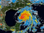
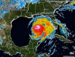
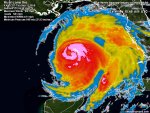
Ike is an unusual storm, to say the least. Reconnaissance aircraft have not found an increase in winds with Ike overnight and they remain at 100 mph, which is anomalously low for the reported central pressure.
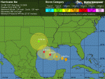
The central pressure being reported by Hurricane Hunter aircraft is 946 millibars and this pressure would normally correspond to a borderline category 3/4 hurricane. Ike has a very large wind field, particularly on the north side of the storm. However, it continues to have a small inner core with an eye just under 10 miles in diameter.
There has been a double wind maximum, although hurricane hunter observations suggest that the outer wind band is beginning to contract. The global models are still forecasting a favorable upper level environment right up to and through landfall and Ike is forecast to strengthen to at least mid to upper Category 3 strength and possibly low end Category 4 strength with 130 to 140 mph winds prior to landfall.
It should be noted that the GFDL and HWRF models continue to forecast that Ike will peak at Category 4 strength during the day Friday and potentially make landfall at that strength.
I still think Ike will strengthen today to Category 3 strength and then strengthen some more tonight into Friday and reach borderline Category 3-Category 4 strength (130 to 140 mph winds) sometime on Friday. I then am forecasting Ike to maintain borderline Category 3-Category 4 strength (130 to 140 mph) right through landfall, which is now forecast to occur around 5 am Eastern/4 am Central Time Saturday morning.
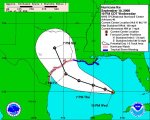
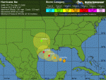
I want to explicitly state that this is a VERY DANGEROUS situation. A borderline Category 3-Category 4 hurricane is forecast to make landfall somewhere between Matagorda and Galveston early Saturday morning.
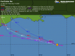
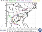
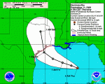
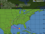
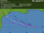
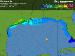
Ike has turned back to the west-northwest and is moving at a forward speed of 9 mph. The track model guidance are in good agreement on a continued west-northwest motion today through Friday to the south of a strong ridge of high pressure that extends from the southeastern United States to Texas.
The model guidance forecast that the portion of the ridge of high pressure over Texas will weaken on Friday night and Saturday and this would likely cause Ike to turn to the northwest and north. There continues to be some disagreement among the models as to how soon and how sharp of a turn will occur.
The HWRF model forecasts a landfall near Calhoun County, while the GFDL model, consensus models and the European model forecast a landfall in Brazoria County. The GFS model is forecasting a landfall near Matagorda and Port O' Connor early Saturday morning.
Here is my thinking as of this morning: I agree wholeheartedly with the National Hurricane Center and am thinking that Ike will come ashore somewhere between San Antonio Bay and Galveston early Saturday morning around 5 am Eastern/4 am Central.
This area is centered right on Matagorda and Brazoria Counties. I anticipate Ike to make landfall as a borderline Category 3-Category 4 hurricane with winds of 130 to 140 mph. The forecast track of Ike is still somewhat uncertain and all interests along the entire Texas coast into southwestern Louisiana should be preparing for a major hurricane landfall. Ike is also expected to be a very large storm in overall size and its effects will be felt all over the Gulf of Mexico.
A Hurricane Watch remains in effect from Cameron, Louisiana to Port Mansfield, Texas.
Residents that are under mandatory evacuation orders, please complete your preparations and leave. This is a very serious hurricane threat. A large and destructive storm surge will cross the middle and upper Texas coast. Failure to evacuate may result in loss of life.
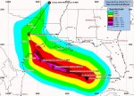
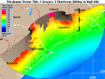
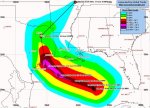
Storm Surge Forecast: The following storm surge forecasts are based on the current forecast track and forecast intensity for Hurricane Ike. The surge forecasts are subject to change based on any future changes in the forecast. If the track shifts eastward, the these surge levels may be increased dramatically for the Galveston Bay region.
Surge levels will exceed 5 feet above normal along the upper Texas coast beginning Friday morning. Maximum surge levels will occur on Friday night through Saturday morning. The maximum surge levels are highly dependent on the track of the storm and variations of only 15 miles can make differences of 5 to 10 feet more or less from some of these values.
Maximum surge forecast:
Shoreline of Matagorda Bay: 15 to 20 feet.
Coastal areas from Matagorda to High Island, including the shores of Galveston Bay: 12 to 16 feet
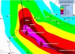
Wind Forecast: Tropical storm force winds in excess of 40 mph are expected to reach the coast of Texas around noon Friday. Winds of at least tropical storm force will then last for about 24 hours straight.
Depending on the eventual track and strength of Ike, hurricane force winds are expected to reach the coastal counties from Port O' Connor to Sabine Pass before midnight Friday evening. Hurricane force winds will then last for about 12 hours.
Peak winds of 100 to 130 mph are expected across coastal areas from Matagorda to High Island, especially where the eyewall makes landfall. This area does include Freeport, Galveston and Houston!!
This is what to expect in terms of wind damage across coastal areas of Matagorda, Brazoria, Galveston and Chambers Counties: Widespread damage and destruction of mobile homes is likely.
Structural damage will include the majority of mobile homes being severely damaged. Those that survive will be uninhabitable until repaired. Houses of poor to average construction will have major damage, including partial wall collapse and roofs being lifted off. Many will be uninhabitable.
Well constructed houses will incur minor damage to shingles, siding, gutters, as well as blown out windows. Up to one quarter of gabled roofs will fail.
Partial roof failure is expected at Industrial Parks, especially to those buildings with light weight steel and aluminum coverings.
Older low rising apartment roofs may also be torn off, as well as receiving siding and shingle damage. Up to one quarter of all glass in high rise office buildings will be blown out. Airborne debris will cause damage, injury and possible fatalities.
Natural damage will include all trees with rotting bases becoming uprooted or snapped. Nearly all large branches will snap. Between one quarter and one half of healthy small to medium sized trees will be snapped or uprooted, most common where the ground is saturated.
Across those areas inland from the coast, including areas along and east of Interstate 45 as far inland as 100 to 125 miles: Poorly constructed or unsecured mobile homes will be destroyed. Others will have substantial damage to roofs, walls and windows, and will likely be uninhabitable until repaired. Houses of poor to average construction will have partial wall and roof failure, as well as blown out windows. Unsecured light to moderate weight outdoor items will become projectiles, causing additional damage. Many areas will have power outages, hundreds of wires will fall, transformers will pop, and some power poles will be pulled down.
Rotting large trees will be uprooted, most common on saturated ground. Numerous large branches of healthy trees will snap. Up to one half of newly planted crops will be damaged.
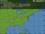
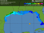
As already stated, this is an extremely large hurricane and the effects will be very far reaching. Tropical storm force winds will extend outward up to 260 miles at landfall with hurricane force winds extending outward up to 120 miles. Ike's very strong winds will extend well inland due to the hurricane's accelerating speed at landfall. Damaging hurricane force winds are likely as far inland as 150 miles from the coast. Areas roughly along and east of Interstate 45 up to 150 miles inland will experience hurricane force winds. Tropical storm force winds will likely extend inland to Dallas and Tyler and quite possibly into southeastern Oklahoma.
In conclusion, this is a VERY DANGEROUS hurricane. A borderline Category 3-Category 4 hurricane is forecast to make landfall on the Texas coast somewhere in Matagorda or Brazoria Counties around 5 am Eastern/4 am Central Time Saturday morning. Residents under evacuation orders, please complete your preparations and leave. This is a very serious hurricane threat. A large and destructive storm surge will cross the middle and upper Texas coast. Failure to evacuate may result in loss of life.
The next update on Hurricane Ike will be issued by 2 pm EDT/1 pm CDT This Afternoon.
Prepared by Rob Lightbown, Crown Weather Services