
You are using an out of date browser. It may not display this or other websites correctly.
You should upgrade or use an alternative browser.
You should upgrade or use an alternative browser.
WEATHER Hurricane Ike Daily Thread For Saturday 9-13-08
- Thread starter Jarhead
- Start date
-
- Tags
- disaster hurricane ike
breezyhill
Veteran Member
KHOU reporting that a couple in Chrystal Beach called the fire dept. for rescue. They are on the second floor of thier 2 story home, waist deep in water. fire dept told can't get to them.
I hope they prepped with an axe in the attic

bh
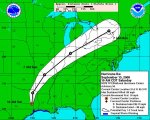
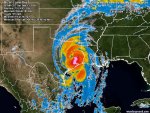
HURRICANE IKE DISCUSSION NUMBER 49
NWS TPC/NATIONAL HURRICANE CENTER MIAMI FL AL092008
500 AM EDT SAT SEP 13 2008
THE 40 NM WIDE EYE OF IKE MADE LANDFALL ON THE UPPER TEXAS COAST
JUST AFTER 0700 UTC. AIRCRAFT AND RADAR DATA INDICATE THAT THE
LANDFALL INTENSITY WAS 95 KT...CATEGORY 2 ON THE SAFFIR SIMPSON
SCALE. SURFACE OBSERVATIONS SUGGEST THE LANDFALL PRESSURE WAS NEAR
952 MB. THE STORM HAS NOT YET HAD TIME TO SIGNIFICANTLY WEAKEN...
SO 95 KT IS THE INITIAL INTENSITY FOR THIS ADVISORY. IKE SHOULD
WEAKEN AS THE CENTER MOVES FARTHER INLAND...WITH THE CYCLONE
FORECAST TO DROP BELOW HURRICANE STRENGTH BY LATE SATURDAY
AFTERNOON AND BELOW TROPICAL STORM STRENGTH ON SUNDAY. IKE IS
EXPECTED TO LOSE TROPICAL CHARACTERISTICS BY 48 HR AND BE ABSORBED
INTO A FRONTAL ZONE THEREAFTER.
THE INITIAL MOTION IS A RATHER WOBBLY 325/11. IKE IS ROUNDING THE
WESTERN PERIPHERY OF A DEEP-LAYER RIDGE OVER THE SOUTHEASTERN
UNITED STATES...AND IT SHOULD RECURVE AND ACCELERATE INTO THE
WESTERLIES DURING THE NEXT 24-36 HR. ALL GUIDANCE AGREES WITH THIS
SCENARIO...WITH THE GUIDANCE SHOWING A LITTLE SPREAD IN THE FORWARD
SPEED AFTER RECURVATURE. THE NEW FORECAST TRACK IS NUDGED A LITTLE
TO THE EAST OF THE PREVIOUS TRACK AND LIES NEAR THE CENTER OF THE
GUIDANCE ENVELOPE.
EVEN THOUGH IKE HAS MADE LANDFALL...IT REMAINS A VERY LARGE AND
DANGEROUS HURRICANE WITH EFFECTS FELT AT LONG DISTANCES FROM THE
CENTER. WATER LEVELS ALONG PORTIONS OF THE UPPER TEXAS AND
SOUTHWESTERN LOUISIANA COASTS MAY CONTINUE TO RISE FOR SEVERAL MORE
HOURS. ADDITIONALLY...HURRICANE-FORCE WINDS MAY OCCUR WELL INLAND
NEAR AND TO THE EAST OF THE CENTER OF IKE.
PRELIMINARY LOCAL STORM REPORT
NATIONAL WEATHER SERVICE HOUSTON/GALVESTON TX
204 AM CDT SAT SEP 13 2008
..TIME.. ...EVENT... ...CITY LOCATION... ...LAT.LON...
..DATE.. ....MAG.... ..COUNTY LOCATION.. ST.. ...SOURCE....
..REMARKS..
0145 AM HURRICANE GALVESTON 29.23N 94.89W
09/13/2008 GALVESTON TX EMERGENCY MNGR
6 FT OF WATER IN THE DOWNTOWN GALVESTON COUNTY
COURTHOUSE
---------
PRELIMINARY LOCAL STORM REPORT
NATIONAL WEATHER SERVICE HOUSTON/GALVESTON TX
246 AM CDT SAT SEP 13 2008
..TIME.. ...EVENT... ...CITY LOCATION... ...LAT.LON...
..DATE.. ....MAG.... ..COUNTY LOCATION.. ST.. ...SOURCE....
..REMARKS..
0245 AM HURRICANE ANAHUAC 29.76N 94.68W
09/13/2008 CHAMBERS TX STORM CHASER
102 MPH WIND GUST REPORTED AT ANAUAC BY UAH MOBILE
RADAR TEAM
--------
PRELIMINARY LOCAL STORM REPORT
NATIONAL WEATHER SERVICE HOUSTON/GALVESTON TX
1145 PM CDT FRI SEP 12 2008
..TIME.. ...EVENT... ...CITY LOCATION... ...LAT.LON...
..DATE.. ....MAG.... ..COUNTY LOCATION.. ST.. ...SOURCE....
..REMARKS..
1100 PM STORM SURGE GALVESTON 29.23N 94.89W
09/12/2008 E11 FT GALVESTON TX EMERGENCY MNGR
UTMB HOSPITAL FIRST FLOOR FLOODED
---------
NATIONAL WEATHER SERVICE HOUSTON/GALVESTON TX
204 AM CDT SAT SEP 13 2008
..TIME.. ...EVENT... ...CITY LOCATION... ...LAT.LON...
..DATE.. ....MAG.... ..COUNTY LOCATION.. ST.. ...SOURCE....
..REMARKS..
0145 AM HURRICANE GALVESTON 29.23N 94.89W
09/13/2008 GALVESTON TX EMERGENCY MNGR
6 FT OF WATER IN THE DOWNTOWN GALVESTON COUNTY
COURTHOUSE
---------
PRELIMINARY LOCAL STORM REPORT
NATIONAL WEATHER SERVICE HOUSTON/GALVESTON TX
246 AM CDT SAT SEP 13 2008
..TIME.. ...EVENT... ...CITY LOCATION... ...LAT.LON...
..DATE.. ....MAG.... ..COUNTY LOCATION.. ST.. ...SOURCE....
..REMARKS..
0245 AM HURRICANE ANAHUAC 29.76N 94.68W
09/13/2008 CHAMBERS TX STORM CHASER
102 MPH WIND GUST REPORTED AT ANAUAC BY UAH MOBILE
RADAR TEAM
--------
PRELIMINARY LOCAL STORM REPORT
NATIONAL WEATHER SERVICE HOUSTON/GALVESTON TX
1145 PM CDT FRI SEP 12 2008
..TIME.. ...EVENT... ...CITY LOCATION... ...LAT.LON...
..DATE.. ....MAG.... ..COUNTY LOCATION.. ST.. ...SOURCE....
..REMARKS..
1100 PM STORM SURGE GALVESTON 29.23N 94.89W
09/12/2008 E11 FT GALVESTON TX EMERGENCY MNGR
UTMB HOSPITAL FIRST FLOOR FLOODED
---------
BULLETIN - EAS ACTIVATION REQUESTED
TORNADO WARNING
NATIONAL WEATHER SERVICE LAKE CHARLES LA
514 AM CDT SAT SEP 13 2008
THE NATIONAL WEATHER SERVICE IN LAKE CHARLES HAS ISSUED A
* TORNADO WARNING FOR...
NORTHEASTERN JASPER COUNTY IN SOUTHEAST TEXAS...
THIS INCLUDES...KIRBYVILLE...JASPER...
NEWTON COUNTY IN SOUTHEAST TEXAS...
THIS INCLUDES...TOLEDO BEND DAM...NEWTON...DEWEYVILLE...CALL...
BURKEVILLE...BON WEIR...
EXTREME NORTHEASTERN ORANGE COUNTY IN SOUTHEAST TEXAS...
WESTERN BEAUREGARD PARISH IN SOUTHWEST LOUISIANA...
THIS INCLUDES...MERRYVILLE...FIELDS...
NORTHWESTERN CALCASIEU PARISH IN SOUTHWEST LOUISIANA...
THIS INCLUDES STARKS...
SOUTHWESTERN VERNON PARISH IN WEST CENTRAL LOUISIANA...
* UNTIL 600 AM CDT
* AT 513 AM CDT...NATIONAL WEATHER SERVICE DOPPLER RADAR INDICATED A
SEVERE THUNDERSTORM CAPABLE OF PRODUCING A TORNADO 8 MILES
SOUTHEAST OF STARKS...OR ABOUT NEAR VINTON...MOVING NORTH AT 90
MPH.
* THE TORNADO WILL BE NEAR...
FIELDS BY 520 AM CDT...
BON WEIR BY 530 AM CDT...
NEWTON BY 540 AM CDT...
7 MILES WEST OF BURKEVILLE BY 545 AM CDT...
THE SAFEST PLACE TO BE DURING A TORNADO IS IN A SMALL INTERIOR ROOM.
GET UNDER A WORKBENCH OR OTHER PIECE OF STURDY FURNITURE...SEEK
SHELTER ON THE LOWEST FLOOR OF THE BUILDING IN AN INTERIOR HALLWAY OR
ROOM SUCH AS A CLOSET. USE BLANKETS OR PILLOWS TO COVER YOUR BODY AND
ALWAYS STAY AWAY FROM WINDOWS.
IF IN MOBILE HOMES OR VEHICLES...EVACUATE THEM AND GET INSIDE A
SUBSTANTIAL SHELTER. IF NO SHELTER IS AVAILABLE...LIE FLAT IN THE
NEAREST DITCH OR OTHER LOW SPOT AND COVER YOUR HEAD WITH YOUR HANDS.
A TORNADO WATCH REMAINS IN EFFECT UNTIL 1000 AM CDT SATURDAY MORNING
FOR SOUTHWESTERN LOUISIANA AND SOUTHEAST TEXAS.
The far northern band is just now hitting here. No sustained winds yet, but high gusts about every thirty seconds or so, I'm guessing 50-60 mph. I don't figure I'll have power much longer. Thanks for all the updates Red Baron.
Houston still haspower through most of the city.
Maybe the power will hold at your location!
PRELIMINARY LOCAL STORM REPORT
NATIONAL WEATHER SERVICE HOUSTON/GALVESTON TX
555 AM CDT SAT SEP 13 2008
..TIME.. ...EVENT... ...CITY LOCATION... ...LAT.LON...
..DATE.. ....MAG.... ..COUNTY LOCATION.. ST.. ...SOURCE....
..REMARKS..
0551 AM HURRICANE HOUSTON 29.77N 95.39W
09/13/2008 HARRIS TX BROADCAST MEDIA
GLASS BROKEN OUT OF HIGH RISE BUILDINGS IN DOWN TOWN
HOUSTON. METAL COMING OFF OF BUILDINGS WITH AT LEAST 10
TO 15 FLOORS DAMAGED.
-
PUBLIC INFORMATION STATEMENT
NATIONAL WEATHER SERVICE HOUSTON/GALVESTON TX
550 AM CDT SAT SEP 13 2008
...ONALASKA NOAA WEATHER RADIO TRANSMITTER IS INOPERABLE...
THE NOAA WEATHER RADIO TRANSMITTER AT ONALASKA IS INOPERABLE.
REPAIRS WILL NOT BEGIN UNTIL AFTER THE STORM ENDS. WE APOLOGIZE
FOR THE INCONVENIENCE.
-
PRELIMINARY LOCAL STORM REPORT
NATIONAL WEATHER SERVICE HOUSTON/GALVESTON TX
523 AM CDT SAT SEP 13 2008
..TIME.. ...EVENT... ...CITY LOCATION... ...LAT.LON...
..DATE.. ....MAG.... ..COUNTY LOCATION.. ST.. ...SOURCE....
..REMARKS..
0500 AM HURRICANE DICKINSON 29.45N 95.07W
09/13/2008 GALVESTON TX NWS EMPLOYEE
ESTIMATED WIND GUST OF 72 MPH AT HGX NWS OFFICE
NATIONAL WEATHER SERVICE HOUSTON/GALVESTON TX
555 AM CDT SAT SEP 13 2008
..TIME.. ...EVENT... ...CITY LOCATION... ...LAT.LON...
..DATE.. ....MAG.... ..COUNTY LOCATION.. ST.. ...SOURCE....
..REMARKS..
0551 AM HURRICANE HOUSTON 29.77N 95.39W
09/13/2008 HARRIS TX BROADCAST MEDIA
GLASS BROKEN OUT OF HIGH RISE BUILDINGS IN DOWN TOWN
HOUSTON. METAL COMING OFF OF BUILDINGS WITH AT LEAST 10
TO 15 FLOORS DAMAGED.
-
PUBLIC INFORMATION STATEMENT
NATIONAL WEATHER SERVICE HOUSTON/GALVESTON TX
550 AM CDT SAT SEP 13 2008
...ONALASKA NOAA WEATHER RADIO TRANSMITTER IS INOPERABLE...
THE NOAA WEATHER RADIO TRANSMITTER AT ONALASKA IS INOPERABLE.
REPAIRS WILL NOT BEGIN UNTIL AFTER THE STORM ENDS. WE APOLOGIZE
FOR THE INCONVENIENCE.
-
PRELIMINARY LOCAL STORM REPORT
NATIONAL WEATHER SERVICE HOUSTON/GALVESTON TX
523 AM CDT SAT SEP 13 2008
..TIME.. ...EVENT... ...CITY LOCATION... ...LAT.LON...
..DATE.. ....MAG.... ..COUNTY LOCATION.. ST.. ...SOURCE....
..REMARKS..
0500 AM HURRICANE DICKINSON 29.45N 95.07W
09/13/2008 GALVESTON TX NWS EMPLOYEE
ESTIMATED WIND GUST OF 72 MPH AT HGX NWS OFFICE
PRELIMINARY LOCAL STORM REPORT
NATIONAL WEATHER SERVICE HOUSTON/GALVESTON TX
611 AM CDT SAT SEP 13 2008
..TIME.. ...EVENT... ...CITY LOCATION... ...LAT.LON...
..DATE.. ....MAG.... ..COUNTY LOCATION.. ST.. ...SOURCE....
..REMARKS..
0610 AM HURRICANE HOBBY AIRPORT 29.64N 95.28W
09/13/2008 HARRIS TX TRAINED SPOTTER
HOBBY OBSERVER ESTIMATED 74 MPH SUSTAINED WINDS GUSTING
TO 92 MPH
Knell
Deceased
KHOU has a reporter in the hotel on Galveston where all the media is staying. The windows on the upper floors have broken, others are leaking, until it's raining in the stairwells. The upper floors have been evacuated. He showed one wall that is cracked and leaking at the top and bottom and the wall is bowing with the wind.
PRELIMINARY LOCAL STORM REPORT
NATIONAL WEATHER SERVICE HOUSTON/GALVESTON TX
629 AM CDT SAT SEP 13 2008
..TIME.. ...EVENT... ...CITY LOCATION... ...LAT.LON...
..DATE.. ....MAG.... ..COUNTY LOCATION.. ST.. ...SOURCE....
..REMARKS..
0626 AM HURRICANE TOMBALL 30.10N 95.62W
09/13/2008 HARRIS TX EMERGENCY MNGR
ROOF COLLASPE OF A NURSING HOME NEAR TOMBALL.
KHOU has a reporter in the hotel on Galveston where all the media is staying. The windows on the upper floors have broken, others are leaking, until it's raining in the stairwells. The upper floors have been evacuated. He showed one wall that is cracked and leaking at the top and bottom and the wall is bowing with the wind.
KHOU just showed water bubbling up through the floor at the hotel...
Knell
Deceased
Very heavy gusts here now. Power if flickering and I'm having some minor brown outs. Internet connection is off and on.
Stay safe, Amaryllis!

mole
Doomer Granny
morning everyone,
well, it is daybreak and Ike is over land and STILL a hurricane.
Seems I got a excited a little prematurely yesterday about this monster not tracking directly over us. We are getting local warnings of potential wind gusts of 39-73 mph and instructions to prepare for power outages.
A small local update: We made a run to Wally World late last night and took a quick drive around the I-30 corridor. Every hotel/motel parking lot is packed and we were told that rates are through the roof. The shelves at Wal-mart were extremely bare but the stockers were busy replenishing. All the water was gone, batteries, flashlights, cereal, and the can goods aisle were trashed and picked clean. Not very many people out and about that time of night, but the employees looked shell shocked.
Gas prices are still under $4 per gallon for all types as far as we could tell...that may have changed this morning.
Hubby just called and said that there was a line of about 7-8 power trucks from Springfield (?) heading south on HWY 82 this morning. I am assuming that is Springfield Missouri, but am not sure.
We have battened down the hatches here and are pretty much prepped and ready. Stay safe everyone and I will report back anything that goes on in this neck of the woods.
If I am not online when Jarhead gets back, someone get that sweetheart his morning coffee.
and Red Baron, thanks for all you have done over the night time hours. Great job and much appreciated!!
Deep Blue Dragon
Senior Member
In Bryan we're having the rain bands go through now; wind is blowing 30-40 mph sustained and gusting in the 60's. Heavy rain comes in waves. The trees are swaying wildly but so far only small limbs are coming down. The power is on here at the moment.
DD was up late following reports on Galveston. When she gets up this morning I'll ask if she knows anything about folks that stayed down there (like her landlord). Her landlord's house is right next door to her rental house; her roommate called him mid-day yesterday and the house was still OK then (it is a few blocks inland from the seawall). What the news is showing this morning isn't looking good. If I learn anything more I'll post it here (if the power stays on, that is).
DD was up late following reports on Galveston. When she gets up this morning I'll ask if she knows anything about folks that stayed down there (like her landlord). Her landlord's house is right next door to her rental house; her roommate called him mid-day yesterday and the house was still OK then (it is a few blocks inland from the seawall). What the news is showing this morning isn't looking good. If I learn anything more I'll post it here (if the power stays on, that is).
Harriet The Spy
Contributing Member
People Trapped in Houses in Galveston In Rising Waters
WHOU has report of a man and his daughter from Surfside neighborhood in Galveston who had to wade through neck-high waters to escape their flooded home and reach relative security at the Galveston Island Convention Center. Man said he passed several neighbors who were trapped in their houses on the way to Convention Center. Not good.
Link to report: http://www.khou.com/video/news-index.html?nvid=282425
:::Praying for all folks affected by this hurricane.:::
Jarhead
Has No Life - Lives on TB
000
WTNT34 KNHC 131441
TCPAT4
BULLETIN
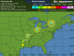
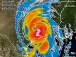
HURRICANE IKE ADVISORY NUMBER 50
NWS TPC/NATIONAL HURRICANE CENTER MIAMI FL AL092008
1000 AM CDT SAT SEP 13 2008
...IKE SLOWLY WEAKENING AS IT MOVES FARTHER INLAND OVER SOUTHEASTERN
TEXAS...
...IKE STILL A HEAVY RAINFALL AND TORNADO THREAT...
AT 10 AM CDT...1500 UTC...THE HURRICANE WARNING FROM EAST OF SARGENT
TEXAS EASTWARD TO MORGAN CITY LOUISIANA HAS BEEN REPLACED BY A
TROPICAL STORM WARNING.
AT 10 AM CDT...THE HURRICANE WARNING HAS BEEN DISCONTINUED FROM
SARGENT TEXAS WESTWARD ALONG THE CENTRAL TEXAS COAST.
FOR STORM INFORMATION SPECIFIC TO YOUR AREA...INCLUDING POSSIBLE
INLAND WATCHES AND WARNINGS...PLEASE MONITOR PRODUCTS ISSUED
BY YOUR LOCAL WEATHER OFFICE.
AT 1000 AM CDT...1500Z...THE CENTER OF HURRICANE IKE WAS LOCATED
NEAR LATITUDE 31.0 NORTH...LONGITUDE 95.3 WEST OR NEAR TRINITY
TEXAS. THIS POSITION IS ALSO ABOUT 20 MILES...35 KM...
NORTH-NORTHEAST OF HUNTSVILLE TEXAS...AND ABOUT 35 MILES...60 KM...
WEST-SOUTHWEST OF LUFKIN TEXAS.
IKE IS MOVING TOWARD THE NORTH NEAR 16 MPH...26 KM/HR. A TURN TOWARD
THE NORTH-NORTHEAST IS EXPECTED LATER TODAY...WITH A TURN TOWARD
THE NORTHEAST AND AN INCREASE IN FORWARD SPEED EXPECTED TONIGHT AND
SUNDAY. ON THE FORECAST TRACK...THE CENTER OF IKE IS FORECAST TO
MOVE THROUGH EASTERN AND NORTHEASTERN TEXAS TODAY...AND INTO
WESTERN ARKANSAS TONIGHT.
MAXIMUM SUSTAINED WINDS HAVE DECREASED TO NEAR 80 MPH...130
KM/HR...WITH HIGHER GUSTS. IKE IS A CATEGORY ONE HURRICANE ON THE
SAFFIR-SIMPSON SCALE. ADDITIONAL WEAKENING IS EXPECTED AS THE
CENTER MOVES FARTHER INLAND. HOWEVER...IKE COULD REMAIN A
HURRICANE INTO THIS AFTERNOON.
HURRICANE FORCE WINDS EXTEND OUTWARD UP TO 45 MILES...75 KM...FROM
THE CENTER...AND TROPICAL STORM FORCE WINDS EXTEND OUTWARD UP TO 230
MILES...370 KM. A WIND GUST TO 56 MPH...91 KM/HR...WAS REPORTED
DURING THE PAST HOUR IN LUFKIN TEXAS.
THE ESTIMATED MINIMUM CENTRAL PRESSURE IS 964 MB...28.47 INCHES.
DURING THE PAST HOUR...A PRESSURE VALUE OF 968.5 MB...28.60
INCHES...WAS REPORTED AT HUNTSVILLE TEXAS TO THE WEST OF THE CENTER
OF HURRICANE IKE.
COASTAL STORM SURGE FLOODING OF UP TO 15 FEET ABOVE NORMAL TIDES...
WITH POSSIBLY UP TO 20 FEET IN BAYS AND RIVERS WELL INLAND...ALONG
WITH LARGE AND DANGEROUS WAVES...CAN BE EXPECTED ALONG THE UPPER
TEXAS AND SOUTHWESTERN LOUISIANA COASTS. THE SURGE EXTENDS A
GREATER THAN USUAL DISTANCE FROM THE CENTER DUE TO THE LARGE SIZE
OF THE CYCLONE. AUTOMATED TIDE GAGES ARE STILL REPORTING STORM
SURGES VALUES OF TO 12 FT ABOVE NORMAL TIDE LEVELS ALONG THE UPPER
TEXAS AND SOUTHWESTERN LOUISIANA COASTAL AREAS.
IKE IS EXPECTED TO PRODUCE RAINFALL AMOUNTS OF 5 TO 10 INCHES OVER
EASTERN TEXAS AND EXTREME SOUTHWESTERN LOUISIANA...WITH ISOLATED
AMOUNTS OF 15 INCHES POSSIBLE. RAINFALL AMOUNTS OF 3 TO 6 INCHES...
WITH MAXIMUM AMOUNTS OF 8 INCHES...ARE POSSIBLE ACROSS SOUTHEASTERN
OKLAHOMA...WESTERN ARKANSAS...SOUTHERN AND EASTERN MISSOURI...
ILLINOIS...NORTHERN INDIANA...AND SOUTHERN LOWER MICHIGAN THROUGH
SUNDAY.
A THREAT FOR TORNADOES EXISTS THROUGH TONIGHT OVER PORTIONS OF
EASTERN AND SOUTHEASTERN TEXAS...SOUTHERN AND WESTERN
LOUISIANA...MUCH OF ARKANSAS...AND SOUTHERN MISSOURI.
REPEATING THE 1000 AM CDT POSITION...31.0 N...95.3 W. MOVEMENT
TOWARD...NORTH NEAR 16 MPH. MAXIMUM SUSTAINED WINDS...80 MPH.
MINIMUM CENTRAL PRESSURE...964 MB.
AN INTERMEDIATE ADVISORY WILL BE ISSUED BY THE NATIONAL HURRICANE
CENTER AT 100 PM CDT FOLLOWED BY THE NEXT COMPLETE ADVISORY AT 400
PM CDT.
$$
FORECASTER STEWART
WTNT34 KNHC 131441
TCPAT4
BULLETIN
HURRICANE IKE ADVISORY NUMBER 50
NWS TPC/NATIONAL HURRICANE CENTER MIAMI FL AL092008
1000 AM CDT SAT SEP 13 2008
...IKE SLOWLY WEAKENING AS IT MOVES FARTHER INLAND OVER SOUTHEASTERN
TEXAS...
...IKE STILL A HEAVY RAINFALL AND TORNADO THREAT...
AT 10 AM CDT...1500 UTC...THE HURRICANE WARNING FROM EAST OF SARGENT
TEXAS EASTWARD TO MORGAN CITY LOUISIANA HAS BEEN REPLACED BY A
TROPICAL STORM WARNING.
AT 10 AM CDT...THE HURRICANE WARNING HAS BEEN DISCONTINUED FROM
SARGENT TEXAS WESTWARD ALONG THE CENTRAL TEXAS COAST.
FOR STORM INFORMATION SPECIFIC TO YOUR AREA...INCLUDING POSSIBLE
INLAND WATCHES AND WARNINGS...PLEASE MONITOR PRODUCTS ISSUED
BY YOUR LOCAL WEATHER OFFICE.
AT 1000 AM CDT...1500Z...THE CENTER OF HURRICANE IKE WAS LOCATED
NEAR LATITUDE 31.0 NORTH...LONGITUDE 95.3 WEST OR NEAR TRINITY
TEXAS. THIS POSITION IS ALSO ABOUT 20 MILES...35 KM...
NORTH-NORTHEAST OF HUNTSVILLE TEXAS...AND ABOUT 35 MILES...60 KM...
WEST-SOUTHWEST OF LUFKIN TEXAS.
IKE IS MOVING TOWARD THE NORTH NEAR 16 MPH...26 KM/HR. A TURN TOWARD
THE NORTH-NORTHEAST IS EXPECTED LATER TODAY...WITH A TURN TOWARD
THE NORTHEAST AND AN INCREASE IN FORWARD SPEED EXPECTED TONIGHT AND
SUNDAY. ON THE FORECAST TRACK...THE CENTER OF IKE IS FORECAST TO
MOVE THROUGH EASTERN AND NORTHEASTERN TEXAS TODAY...AND INTO
WESTERN ARKANSAS TONIGHT.
MAXIMUM SUSTAINED WINDS HAVE DECREASED TO NEAR 80 MPH...130
KM/HR...WITH HIGHER GUSTS. IKE IS A CATEGORY ONE HURRICANE ON THE
SAFFIR-SIMPSON SCALE. ADDITIONAL WEAKENING IS EXPECTED AS THE
CENTER MOVES FARTHER INLAND. HOWEVER...IKE COULD REMAIN A
HURRICANE INTO THIS AFTERNOON.
HURRICANE FORCE WINDS EXTEND OUTWARD UP TO 45 MILES...75 KM...FROM
THE CENTER...AND TROPICAL STORM FORCE WINDS EXTEND OUTWARD UP TO 230
MILES...370 KM. A WIND GUST TO 56 MPH...91 KM/HR...WAS REPORTED
DURING THE PAST HOUR IN LUFKIN TEXAS.
THE ESTIMATED MINIMUM CENTRAL PRESSURE IS 964 MB...28.47 INCHES.
DURING THE PAST HOUR...A PRESSURE VALUE OF 968.5 MB...28.60
INCHES...WAS REPORTED AT HUNTSVILLE TEXAS TO THE WEST OF THE CENTER
OF HURRICANE IKE.
COASTAL STORM SURGE FLOODING OF UP TO 15 FEET ABOVE NORMAL TIDES...
WITH POSSIBLY UP TO 20 FEET IN BAYS AND RIVERS WELL INLAND...ALONG
WITH LARGE AND DANGEROUS WAVES...CAN BE EXPECTED ALONG THE UPPER
TEXAS AND SOUTHWESTERN LOUISIANA COASTS. THE SURGE EXTENDS A
GREATER THAN USUAL DISTANCE FROM THE CENTER DUE TO THE LARGE SIZE
OF THE CYCLONE. AUTOMATED TIDE GAGES ARE STILL REPORTING STORM
SURGES VALUES OF TO 12 FT ABOVE NORMAL TIDE LEVELS ALONG THE UPPER
TEXAS AND SOUTHWESTERN LOUISIANA COASTAL AREAS.
IKE IS EXPECTED TO PRODUCE RAINFALL AMOUNTS OF 5 TO 10 INCHES OVER
EASTERN TEXAS AND EXTREME SOUTHWESTERN LOUISIANA...WITH ISOLATED
AMOUNTS OF 15 INCHES POSSIBLE. RAINFALL AMOUNTS OF 3 TO 6 INCHES...
WITH MAXIMUM AMOUNTS OF 8 INCHES...ARE POSSIBLE ACROSS SOUTHEASTERN
OKLAHOMA...WESTERN ARKANSAS...SOUTHERN AND EASTERN MISSOURI...
ILLINOIS...NORTHERN INDIANA...AND SOUTHERN LOWER MICHIGAN THROUGH
SUNDAY.
A THREAT FOR TORNADOES EXISTS THROUGH TONIGHT OVER PORTIONS OF
EASTERN AND SOUTHEASTERN TEXAS...SOUTHERN AND WESTERN
LOUISIANA...MUCH OF ARKANSAS...AND SOUTHERN MISSOURI.
REPEATING THE 1000 AM CDT POSITION...31.0 N...95.3 W. MOVEMENT
TOWARD...NORTH NEAR 16 MPH. MAXIMUM SUSTAINED WINDS...80 MPH.
MINIMUM CENTRAL PRESSURE...964 MB.
AN INTERMEDIATE ADVISORY WILL BE ISSUED BY THE NATIONAL HURRICANE
CENTER AT 100 PM CDT FOLLOWED BY THE NEXT COMPLETE ADVISORY AT 400
PM CDT.
$$
FORECASTER STEWART
Jarhead
Has No Life - Lives on TB
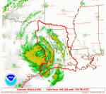
SEL2
URGENT - IMMEDIATE BROADCAST REQUESTED
TORNADO WATCH NUMBER 902
NWS STORM PREDICTION CENTER NORMAN OK
940 AM CDT SAT SEP 13 2008
THE NWS STORM PREDICTION CENTER HAS ISSUED A
TORNADO WATCH FOR PORTIONS OF
SOUTHWESTERN ARKANSAS
WESTERN LOUISIANA
EASTERN TEXAS
COASTAL WATERS
EFFECTIVE THIS SATURDAY MORNING AND EVENING FROM 940 AM UNTIL 700
PM CDT.
TORNADOES...HAIL TO 0.5 INCH IN DIAMETER...THUNDERSTORM WIND
GUSTS TO 70 MPH...AND DANGEROUS LIGHTNING ARE POSSIBLE IN THESE
AREAS.
THE TORNADO WATCH AREA IS APPROXIMATELY ALONG AND 75 STATUTE
MILES EAST AND WEST OF A LINE FROM 65 MILES NORTH OF SHREVEPORT
LOUISIANA TO 45 MILES SOUTH SOUTHEAST OF LAKE CHARLES LOUISIANA.
FOR A COMPLETE DEPICTION OF THE WATCH SEE THE ASSOCIATED WATCH
OUTLINE UPDATE (WOUS64 KWNS WOU2).
REMEMBER...A TORNADO WATCH MEANS CONDITIONS ARE FAVORABLE FOR
TORNADOES AND SEVERE THUNDERSTORMS IN AND CLOSE TO THE WATCH
AREA. PERSONS IN THESE AREAS SHOULD BE ON THE LOOKOUT FOR
THREATENING WEATHER CONDITIONS AND LISTEN FOR LATER STATEMENTS
AND POSSIBLE WARNINGS.
OTHER WATCH INFORMATION...THIS TORNADO WATCH REPLACES TORNADO
WATCH NUMBER 900. WATCH NUMBER 900 WILL NOT BE IN EFFECT AFTER
940 AM CDT.
DISCUSSION...TORNADO THREAT WILL REMAIN ENHANCED FOR MUCH OF THE DAY
ACROSS WW TO THE EAST AND JUST NORTH OF HURRICANE IKE SHIFTING NWD
ACROSS ERN TX. EXTREME LOW LEVEL SHEAR IN PLACE WILL MAINTAIN
FAVORABLE CONDITIONS FOR TORNADOES AS HEATING INCREASES THROUGH THE
DAY...WITH GREATEST THREAT ACROSS FAR ERN TX INTO WRN LA...SPREADING
INTO SWRN AR AND POSSIBLY FAR SERN OK LATER TODAY. THREAT APPEARS
TO BE DIMINISHING TO THE SOUTH OF IKE AS WLY LOW LEVEL FLOW LIMITS
HELICITY.
AVIATION...TORNADOES AND A FEW SEVERE THUNDERSTORMS WITH HAIL
SURFACE AND ALOFT TO 0.5 INCH. EXTREME TURBULENCE AND SURFACE
WIND GUSTS TO 60 KNOTS. A FEW CUMULONIMBI WITH MAXIMUM TOPS TO
550. MEAN STORM MOTION VECTOR 19050.
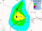
Attachments
Jarhead
Has No Life - Lives on TB
000
WTNT44 KNHC 131500
TCDAT4
HURRICANE IKE DISCUSSION NUMBER 50
NWS TPC/NATIONAL HURRICANE CENTER MIAMI FL AL092008
1100 AM EDT SAT SEP 13 2008
IKE IS CONTINUING TO GRADUALLY WIND DOWN AS A HURRICANE AS IT MOVES
FARTHER INLAND TOWARD EASTERN TEXAS. MAXIMUM DOPPLER VELOCITIES
HAVE DROPPED BELOW 100 KT DURING THE PAST HOUR...SO THE ADVISORY
INTENSITY HAS BEEN LOWERED TO 70 KT...WHICH COULD BE A LITTLE
GENEROUS. HOWEVER...A SURFACE PRESSURE OF 968.5 MB WAS REPORTED TO
THE WEST OF THE EYE AT HUNTSVILLE TEXAS...SO I WOULD RATHER ERR ON
THE SIDE OF CAUTION AND NOT BRING THE WINDS DOWN TOO QUICKLY...
ESPECIALLY WITH STRONG CONVECTIVE BANDS NOTED IN THE SOUTHERN
SEMICIRCLE.
THE INITIAL MOTION ESTIMATE IS 360/14. IKE IS MOVING NORTHWARD
AROUND THE WESTERN PERIPHERY OF A DEEP-LAYER RIDGE SITUATED
EAST-WEST OVER THE SOUTHEASTERN UNITED STATES. IKE IS EXPECTED TO
GRADUALLY ACCELERATE AND RECURVE TO THE NORTHEAST LATER TONIGHT AS
THE CYCLONE COMES UNDER THE INFLUENCE OF FAST SOUTHWESTERLY FLOW
AHEAD OF A SHARP FRONTAL SYSTEM FOR THIS TIME OF THE YEAR. BY 24-36
HOURS...IT IS POSSIBLE THAT IKE MAY BE ABSORBED BY THE FRONTAL
SYSTEM OR TRANSITION INTO AN EXTRATROPICAL CYCLONE. HOWEVER...THE
EXPECTED FORWARD SPEED OF IKE'S SURFACE LOW IS SLOWER IN THE
ADVISORY THAN MANY OF THE GLOBAL MODELS ARE SUGGESTING DUE TO
ANTICIPATION OF THE MID- AND UPPER-LEVEL CIRCULATIONS DECOUPLING
FROM THE LOW-LEVELS AND RACING RAPIDLY OFF TO THE NORTHEAST DUE TO
VERTICAL SHEAR INCREASING TO MORE THAN 100 KT. THE FORECAST TRACK
IS SIMILAR TO THE PREVIOUS ADVISORY TRACK...AND THE TIMING OF
EXTRATROPICAL TRANSITION IS BASED ON INPUT FROM THE NOAA
HYDROMETEOROLOGICAL PREDICTION CENTER.
ALTHOUGH IKE IS SPINNING DOWN AS A HURRICANE IN TERMS OF MAXIMUM
WINDS...UNFORTUNATELY...ATMOSPHERIC CONDITIONS WILL GRADUALLY
BECOME MORE FAVORABLE FOR TORNADOES TO DEVELOP ACROSS MUCH OF
EASTERN TEXAS...WESTERN LOUISIANA...AND ARKANSAS THROUGH TONIGHT.
LOCALLY HEAVY RAINFALL WILL ALSO BE A THREAT...AS WILL CONTINUED
HIGHER THAN NORMAL TIDE LEVELS ALONG MUCH OF THE WESTERN LOUISIANA
AND UPPER TEXAS COASTAL AREAS THROUGH AT LEAST THIS AFTERNOON.
FORECAST POSITIONS AND MAX WINDS
INITIAL 13/1500Z 31.0N 95.3W 70 KT...INLAND
12HR VT 14/0000Z 33.2N 95.1W 45 KT...INLAND
24HR VT 14/1200Z 36.7N 92.3W 30 KT...BECOMING EXTRATROPICAL
36HR VT 15/0000Z 40.6N 86.2W 30 KT...EXTRATROPICAL
48HR VT 15/1200Z 44.5N 77.2W 30 KT...EXTRATROPICAL
72HR VT 16/1200Z...ABSORBED BY FRONTAL ZONE
$$
FORECASTER STEWART
Jarhead
Has No Life - Lives on TB
000
WTNT24 KNHC 131440
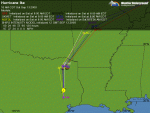
TCMAT4
HURRICANE IKE FORECAST/ADVISORY NUMBER 50
NWS TPC/NATIONAL HURRICANE CENTER MIAMI FL AL092008
1500 UTC SAT SEP 13 2008
AT 10 AM CDT...1500 UTC...THE HURRICANE WARNING FROM EAST OF SARGENT
TEXAS EASTWARD TO MORGAN CITY LOUISIANA HAS BEEN REPLACED BY A
TROPICAL STORM WARNING.
AT 10 AM CDT...THE HURRICANE WARNING HAS BEEN DISCONTINUED FROM
SARGENT TEXAS WESTWARD ALONG THE CENTRAL TEXAS COAST.
HURRICANE CENTER LOCATED NEAR 31.0N 95.3W AT 13/1500Z
POSITION ACCURATE WITHIN 15 NM
PRESENT MOVEMENT TOWARD THE NORTH OR 360 DEGREES AT 14 KT
ESTIMATED MINIMUM CENTRAL PRESSURE 964 MB
MAX SUSTAINED WINDS 70 KT WITH GUSTS TO 85 KT.
64 KT....... 30NE 40SE 25SW 20NW.
50 KT....... 65NE 85SE 55SW 45NW.
34 KT.......125NE 200SE 125SW 60NW.
12 FT SEAS.. 0NE 425SE 150SW 0NW.
WINDS AND SEAS VARY GREATLY IN EACH QUADRANT. RADII IN NAUTICAL
MILES ARE THE LARGEST RADII EXPECTED ANYWHERE IN THAT QUADRANT.
REPEAT...CENTER LOCATED NEAR 31.0N 95.3W AT 13/1500Z
AT 13/1200Z CENTER WAS LOCATED NEAR 30.3N 95.3W
FORECAST VALID 14/0000Z 33.2N 95.1W...INLAND
MAX WIND 45 KT...GUSTS 60 KT.
34 KT... 70NE 100SE 60SW 40NW.
FORECAST VALID 14/1200Z 36.7N 92.3W...BECOMING EXTRATROPICAL INLAND
MAX WIND 30 KT...GUSTS 45 KT.
FORECAST VALID 15/0000Z 40.6N 86.2W...EXTRATROPICAL INLAND
MAX WIND 30 KT...GUSTS 40 KT.
FORECAST VALID 15/1200Z 44.5N 77.2W...EXTRATROPICAL INLAND
MAX WIND 30 KT...GUSTS 40 KT.
FORECAST VALID 16/1200Z...ABSORBED BY FRONTAL ZONE
EXTENDED OUTLOOK. NOTE...ERRORS FOR TRACK HAVE AVERAGED NEAR 250 NM
ON DAY 4 AND 325 NM ON DAY 5...AND FOR INTENSITY NEAR 20 KT EACH DAY
REQUEST FOR 3 HOURLY SHIP REPORTS WITHIN 300 MILES OF 31.0N 95.3W
NEXT ADVISORY AT 13/2100Z
$$
FORECASTER STEWART
WTNT24 KNHC 131440
TCMAT4
HURRICANE IKE FORECAST/ADVISORY NUMBER 50
NWS TPC/NATIONAL HURRICANE CENTER MIAMI FL AL092008
1500 UTC SAT SEP 13 2008
AT 10 AM CDT...1500 UTC...THE HURRICANE WARNING FROM EAST OF SARGENT
TEXAS EASTWARD TO MORGAN CITY LOUISIANA HAS BEEN REPLACED BY A
TROPICAL STORM WARNING.
AT 10 AM CDT...THE HURRICANE WARNING HAS BEEN DISCONTINUED FROM
SARGENT TEXAS WESTWARD ALONG THE CENTRAL TEXAS COAST.
HURRICANE CENTER LOCATED NEAR 31.0N 95.3W AT 13/1500Z
POSITION ACCURATE WITHIN 15 NM
PRESENT MOVEMENT TOWARD THE NORTH OR 360 DEGREES AT 14 KT
ESTIMATED MINIMUM CENTRAL PRESSURE 964 MB
MAX SUSTAINED WINDS 70 KT WITH GUSTS TO 85 KT.
64 KT....... 30NE 40SE 25SW 20NW.
50 KT....... 65NE 85SE 55SW 45NW.
34 KT.......125NE 200SE 125SW 60NW.
12 FT SEAS.. 0NE 425SE 150SW 0NW.
WINDS AND SEAS VARY GREATLY IN EACH QUADRANT. RADII IN NAUTICAL
MILES ARE THE LARGEST RADII EXPECTED ANYWHERE IN THAT QUADRANT.
REPEAT...CENTER LOCATED NEAR 31.0N 95.3W AT 13/1500Z
AT 13/1200Z CENTER WAS LOCATED NEAR 30.3N 95.3W
FORECAST VALID 14/0000Z 33.2N 95.1W...INLAND
MAX WIND 45 KT...GUSTS 60 KT.
34 KT... 70NE 100SE 60SW 40NW.
FORECAST VALID 14/1200Z 36.7N 92.3W...BECOMING EXTRATROPICAL INLAND
MAX WIND 30 KT...GUSTS 45 KT.
FORECAST VALID 15/0000Z 40.6N 86.2W...EXTRATROPICAL INLAND
MAX WIND 30 KT...GUSTS 40 KT.
FORECAST VALID 15/1200Z 44.5N 77.2W...EXTRATROPICAL INLAND
MAX WIND 30 KT...GUSTS 40 KT.
FORECAST VALID 16/1200Z...ABSORBED BY FRONTAL ZONE
EXTENDED OUTLOOK. NOTE...ERRORS FOR TRACK HAVE AVERAGED NEAR 250 NM
ON DAY 4 AND 325 NM ON DAY 5...AND FOR INTENSITY NEAR 20 KT EACH DAY
REQUEST FOR 3 HOURLY SHIP REPORTS WITHIN 300 MILES OF 31.0N 95.3W
NEXT ADVISORY AT 13/2100Z
$$
FORECASTER STEWART
Good Twitter (short messages) update from a bunch of people, ongoing...
http://twitter.com/hurricaneike
http://twitter.com/hurricaneike
Oilpatch Hand
3-Bomb General, TB2K Army
Local forecasters were saying that once Ike made landfall, it would zip north very rapidly.
Looks like it's doing exactly that.
Looks like it's doing exactly that.
Jarhead
Has No Life - Lives on TB
Tropical Weather Discussion
Issued: Saturday, September 13, 2008 1110 am EDT
--------------------------------------------------------------------------------
Hurricane Ike:
Ike made landfall on the upper Texas coast just after 3 am Eastern/2 am Central Time early, early this morning as a 110 mph Category 2 hurricane. Since then, Ike has weakened and as of late this morning is a 80 mph Category 1 hurricane.
Further weakening is expected this afternoon into tonight and in fact Ike is expected to become extratropical by Sunday. Therefore, the threat from Ike will slowly translate from a wind and surge threat to a heavy flooding rain threat and the threat for tornadoes as the afternoon progresses and into tonight.
With that said, strong winds of up to near hurricane force are still expected across much of eastern Texas this afternoon into tonight, as far west as some of the eastern suburbs of Dallas. Strong winds of tropical storm force are also expected across southeastern Oklahoma and western Arkansas this afternoon through tonight.
Widespread rainfall amounts of 5 to 7 inches with isolated rainfall totals of 10 to 12 inches are expected from eastern Texas north and east all the way to northern Illinois and southern Michigan this afternoon through tonight and then spreading eastward into northern New York and southeastern Ontario on Sunday and Sunday night. Significant river and stream flooding is possible in areas of heaviest rainfall.
The threat for tornadoes will exist this afternoon through tonight across eastern Texas, southeastern Oklahoma, much of Louisiana, Arkansas, and southern Missouri.
On Sunday and Sunday night, the threat for tornadoes from Ike will shift northeast into southern Illinois, much of Indiana and much of Ohio. If a Tornado Warning is issued for your location, you should plan to seek shelter in an interior room on the lowest floor away from windows.
This will be my last discussion concerning Ike. I am not planning on writing a tropical weather discussion on Sunday, therefore, the next tropical weather discussion will be issued by 7 am EDT Monday morning.
If you would like up-to-date information on Ike, just visit our Ike Page.
Prepared by Rob Lightbown, Crown Weather Services
Jarhead
Has No Life - Lives on TB
000
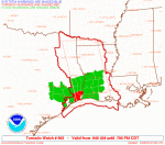
WFUS54 KLCH 131509
TORLCH
TXC199-241-245-351-361-131545-
/O.NEW.KLCH.TO.W.0125.080913T1509Z-080913T1545Z/
BULLETIN - EAS ACTIVATION REQUESTED
TORNADO WARNING
NATIONAL WEATHER SERVICE LAKE CHARLES LA
1009 AM CDT SAT SEP 13 2008
THE NATIONAL WEATHER SERVICE IN LAKE CHARLES HAS ISSUED A
* TORNADO WARNING FOR...
EXTREME SOUTHEASTERN HARDIN COUNTY IN SOUTHEAST TEXAS...
EASTERN JASPER COUNTY IN SOUTHEAST TEXAS...
THIS INCLUDES...KIRBYVILLE...JASPER...BUNA...
EASTERN JEFFERSON COUNTY IN SOUTHEAST TEXAS...
THIS INCLUDES...PORT NECHES...PORT ARTHUR...NEDERLAND...GROVES...
CENTRAL GARDENS...
NEWTON COUNTY IN SOUTHEAST TEXAS...
THIS INCLUDES...NEWTON...CALL...BURKEVILLE...
ORANGE COUNTY IN SOUTHEAST TEXAS...
THIS INCLUDES...WEST ORANGE...VIDOR...ORANGE...MAURICEVILLE...
BRIDGE CITY...
* UNTIL 1045 AM CDT
* AT 1007 AM CDT...NATIONAL WEATHER SERVICE DOPPLER RADAR INDICATED A
LINE OF SEVERE THUNDERSTORMS CAPABLE OF PRODUCING A TORNADO ALONG A
LINE EXTENDING FROM CALL TO CENTRAL GARDENS...MOVING NORTH AT 43
MPH.
* TORNADO PRODUCING STORMS WILL BE NEAR...
VIDOR BY 1015 AM CDT...
KIRBYVILLE AND 6 MILES WEST OF NEWTON BY 1030 AM CDT...
BUNA AND 7 MILES EAST OF JASPER BY 1045 AM CDT...
THE SAFEST PLACE TO BE DURING A TORNADO IS IN A SMALL INTERIOR ROOM.
GET UNDER A WORKBENCH OR OTHER PIECE OF STURDY FURNITURE...SEEK
SHELTER ON THE LOWEST FLOOR OF THE BUILDING IN AN INTERIOR HALLWAY OR
ROOM SUCH AS A CLOSET. USE BLANKETS OR PILLOWS TO COVER YOUR BODY AND
ALWAYS STAY AWAY FROM WINDOWS.
IF IN MOBILE HOMES OR VEHICLES...EVACUATE THEM AND GET INSIDE A
SUBSTANTIAL SHELTER. IF NO SHELTER IS AVAILABLE...LIE FLAT IN THE
NEAREST DITCH OR OTHER LOW SPOT AND COVER YOUR HEAD WITH YOUR HANDS.
A TORNADO WATCH REMAINS IN EFFECT UNTIL 700 PM CDT SATURDAY EVENING
FOR SOUTHWESTERN LOUISIANA AND SOUTHEAST TEXAS.
LAT...LON 3037 9405 3109 9403 3117 9360 3043 9377
3009 9375 2997 9381 2995 9385 2985 9393
2979 9394 2970 9400 2966 9421
TIME...MOT...LOC 1509Z 182DEG 38KT 3066 9387 3005 9398
$$
06
Jarhead
Has No Life - Lives on TB
Ike Strikes Galveston and Houston
Tim Ballisty, Meteorologist, The Weather Channel
11:00 a.m. ET 9/13/2008Hurricane Ike
Ike made landfall at 2:10 a.m. CDT at Galveston, Texas, with maximum sustained winds near 110 miles per hour. Its minimum pressure was 951.6 millibars, reported by the barometer at the Galveston Pleasure Pier when the center passed overhead.
As of 10 a.m. CDT, Ike was located right over Trinity, Texas, with maximum sustained winds at 80 mph. It is heading north at 16 mph with a turn to the north-northeast expected later today.
Hurricane warnings have been discontinued. A tropical storm warning remains in effect from Morgan City, Louisiana, to Sargent, Texas.
Tropical storm and hurricane conditions are being reported anywhere from Houston/Galvston east to Beaumont and Lake Charles and north to Lufkin, Texas.
There are numerous wind reports, surge reports, and damage reports coming in to weather.com.
You can follow along with the latest news and stats concerning Hurricane Ike by clicking here. Updates will be made fairly frequently.
Metro Houston faced a wicked blow from Ike this morning. Aside from the coastal flooding on the southeast side of the city along the western bay, Houston will deal with sustained tropical storm-force winds with numerous gusts to hurricane force. Once the center passes I-10, the metro area will see a slow decrease in winds but the heavy rain will continue into the afternoon.
Skyscrapers endured higher winds this morning than compared to the street level because of their elevation. Windows have been blown out in several of these very tall buildings throughout downtown Houston.
A very preliminary look tells us that water level rise forecasts did not reach their predicted levels, however, there was still considerable coastal flooding due to surge.
Final official measurements will be investigated during the next few days. It is possible that higher surge levels could be discovered when the surveys are completed especially along the west side of Galveston Bay.
Here's a quick glance at some of the highest surge levels:
Sabine Pass, Texas - 14.24 feet
Lake Charles, Louisiana - 10-12 feet
Galveston, Texas - 9-11 feet
The main reason behind the lower than forecast totals can mainly be attributed to a landfall just slightly farther east along Galveston Island. This did not allow for a pure southeast trajectory of winds channeling into Galveston Bay.
As Ike continues inland, flooding rains and potentially damaging winds will spread inland across Texas. Inland tropical storm warnings are in effect for cities as far north as the Red River, including the Dallas/Fort Worth area, with inland hurricane wind warnings as far north as Tyler, Texas.
As Ike weakens Sunday, the flooding rains will shift into eastern Oklahoma, northern Arkansas, southeast Kansas, central and southern Missouri and southern Illinois.
For the latest on the busy tropics, stay tuned to The Weather Channel and updates here on weather.com.
BlueNewton
Membership Revoked
WHOU has report of a man and his daughter from Surfside neighborhood in Galveston who had to wade through neck-high waters to escape their flooded home and reach relative security at the Galveston Island Convention Center. Man said he passed several neighbors who were trapped in their houses on the way to Convention Center. Not good.
Link to report: http://www.khou.com/video/news-index.html?nvid=282425
:::Praying for all folks affected by this hurricane.:::
I listened to this man tell his story. Absolutely horrifying. I hope we get more news out of Galveston soon--some good news, please.
Jonas Parker
Hooligan
We're catching it now. Power has been on and off three times, and just blipped again. Glad we moved the car next to the house since there's a large tree branch now in our regular parking spot. I'll get this posted while I still have power.
Deep Blue Dragon
Senior Member
The Galveston Daily News website is back up, but I don't see any info from today yet:
http://galvestondailynews.com/
However, they did have a link to a reporter who is posting updates on another website and there is a lot of damage to specific areas in Galveston reported there:
http://twitter.com/leighjones
http://galvestondailynews.com/
However, they did have a link to a reporter who is posting updates on another website and there is a lot of damage to specific areas in Galveston reported there:
http://twitter.com/leighjones
BlueNewton
Membership Revoked
Thanks DBD.
Jarhead
Has No Life - Lives on TB
Just an update.....
The crew of that freighter that was adrift during the storm are safe. They are awaiting a tug to bring them back to port.
Link to story: http://www.cnn.com/2008/US/weather/09/13/ike.rescue/index.html
Jarhead

The crew of that freighter that was adrift during the storm are safe. They are awaiting a tug to bring them back to port.
Link to story: http://www.cnn.com/2008/US/weather/09/13/ike.rescue/index.html
Jarhead
Jarhead
Has No Life - Lives on TB
Ike's winds prevent rescues, as flooding rivals Rita
(CNN) -- The storm surge from Hurricane Ike flooded 1,800 homes in Cameron Parish, Louisiana, and authorities told stranded residents to stay indoors Saturday because authorities could not rescue them yet.
The residents weren't in danger, officials said.
Authorities also were urging residents who evacuated not to return until advised to do so.
"We're telling people stay where you are. Don't rush home. We're not out of the woods yet," Cameron Parish Sheriff Theos Dunhon said.
Cameron Parish was hit hard by Hurricane Rita in 2005.
"We are seeing the same flood inundation as Rita, if not more," Dunhon said.
The sheriff's office has received several calls from people in trailers and homes who want to be evacuated, but deputies can't help them because of high winds, Dunhon said.
The sheriff's office has boats ready, and will dispatch search-and-rescue teams when the winds die down, he said.
Cameron Parish, which has about 8,000 residents, is Louisiana's westernmost and borders Texas.
Just north of Cameron Parish, in Lake Charles Mayor Randy Roach echoed the concerns of the Cameron Parish sheriff, telling The Associated Press that flooding there is worse than it was during Hurricane Rita.
The AP reported that the storm surge has breached levees and flooded regions still reeling from Hurricane Gustav, which hit Louisiana and Texas last week.
In Plaquemines Parish near New Orleans, sheriff's spokesman Maj. John Marie told AP that floodwaters are higher than they were during hurricanes Katrina and Rita.