
You are using an out of date browser. It may not display this or other websites correctly.
You should upgrade or use an alternative browser.
You should upgrade or use an alternative browser.
Solar Grand Solar Minimum part deux
- Thread starter Dennis Olson
- Start date
-
- Tags
- grand solar minimum
jed turtle
a brother in the Lord
Glad you could drop by Txgal!
looks like the future has arrived. Between the canadian truck convoy stopping the flow of Trade and the poor weather affecting the world’s harvests, and rampaging inflation, looks like the big paradigm shift is about to commence. I can hardly wait to see what happens next...
looks like the future has arrived. Between the canadian truck convoy stopping the flow of Trade and the poor weather affecting the world’s harvests, and rampaging inflation, looks like the big paradigm shift is about to commence. I can hardly wait to see what happens next...
TxGal
Day by day
A very important article on Electroverse.com (I can really appreciate this one today. Our temp is at 28 and dropping down to the upper teens, we're getting freezing rain and sleet. Hopefully the power will hold!):
Earth's Temperature Saw A Sharp Drop In January, As Did Solar Activity - Global Cooling Is Here, Undeniable, And Set To Intensify - Electroverse

Articles Extreme Weather GSM
EARTH’S TEMPERATURE SAW A SHARP DROP IN JANUARY, AS DID SOLAR ACTIVITY — GLOBAL COOLING IS HERE, UNDENIABLE, AND SET TO INTENSIFY
FEBRUARY 3, 2022 CAP ALLON
The UAH temperate dataset is maintained by former NASA scientist Dr Roy Spencer and his University of Alabama in Huntsville colleague, climate scientist Dr John Christy.
Since 1979, NOAA satellites have been carrying instruments which measure the natural microwave thermal emissions from oxygen in the atmosphere. The intensity of the signals these microwave radiometers measure at different microwave frequencies is directly proportional to the temperature of different, deep layers of the atmosphere. Every month, Dr Spencer and Dr Christy update global temperature datasets that represent the piecing together of the temperature data from a total of fifteen instruments flying on different satellites, know colloquially as ‘the UAH’.
The UAH is the only unbiased temperature dataset we truth-seekers have left. No, it should not be taken as gospel, but with the datasets custodians, Spencer and Christy, not bought and owned by the AGW Party, it is, by far and above, the best we have.
Dr Roy Spencer recently had his website demonitzed by Google. His crime? Questioning a scientific theory, which, as we know, is a stance deemed ‘harmful’ in today’s authoritarian society. Show support for Dr Spencer –by sharing his message– and by doing so, hopefully the last remaining bastion of global temperature analysis can remain unadulterated.
EARTH’S TEMPERATURE SAW A SHARP DROP IN JANUARY…
The Version 6.0 global average lower tropospheric temperature (LT) anomaly for January, 2022 has come in at 0.03 deg. C, continuing the overall downward trend since 2016, now down approx. 0.58C deg. C since then.
In other words, it is get harder and harder for the politicized ‘catastrophic global heating’ narrative to be maintained; but as Gustave Le Bo laments: “The masses have never thirsted after truth. They turn aside from evidence that is not to their taste, preferring to deify error, if error seduces them. Whoever can supply them with illusions is easily their master; whoever attempts to destroy their illusions is always their victim.”
A continuation of this downward trend is probable over the coming months (with the odd bump along the way: climate is cyclic, after all) as low solar activity, La Nina, and the aftereffects of Hunga Tonga’s monstrous stratospheric eruption continue to influence our climate.
View: https://twitter.com/marciocostammsc/status/1484374390720499712
According to the 15x NASA/NOAA AMSU satellites that measure every square inch of the lower troposphere (where us humans reside), planet Earth was actually warmer back in the late 1980s (during the political adoption of the global warming theory):

Below are the various regional LT departures from the 30-year average for the last 13 months. Note in particular the USA48’s stark cool down in Jan compared with Dec (in bold & underlined), with the region down a whopping 1.76C.
YEAR MO GLOBE NHEM. SHEM. TROPIC USA48 ARCTIC AUST
2021 01 0.12 0.34 -0.09 -0.08 0.36 0.50 -0.52
2021 02 0.20 0.32 0.08 -0.14 -0.65 0.07 -0.27
2021 03 -0.01 0.13 -0.14 -0.29 0.59 -0.78 -0.79
2021 04 -0.05 0.05 -0.15 -0.28 -0.02 0.02 0.29
2021 05 0.08 0.14 0.03 0.06 -0.41 -0.04 0.02
2021 06 -0.01 0.31 -0.32 -0.14 1.44 0.63 -0.76
2021 07 0.20 0.33 0.07 0.13 0.58 0.43 0.80
2021 08 0.17 0.27 0.08 0.07 0.33 0.83 -0.02
2021 09 0.25 0.18 0.33 0.09 0.67 0.02 0.37
2021 10 0.37 0.46 0.27 0.33 0.84 0.63 0.06
2021 11 0.08 0.11 0.06 0.14 0.50 -0.42 -0.29
2021 12 0.21 0.27 0.15 0.03 1.63 0.01 -0.06
2022 01 0.03 0.06 0.00 -0.24 -0.13 0.68 0.09
…AS DID SOLAR ACTIVITY
Solar Cycle 25’s recent awakening has tempted some to suggest that the cycle will be stronger than its predecessor; but “not so fast,” cautions Dr. Ron Turner, an analyst at the ANSER research institute in Virginia.
Sunspot numbers, a great barometer for solar activity, have just been tabulated for January, and while they continue to outperform the official NASA forecast, “it may be too early to anticipate a strong solar cycle,” says Turner.
This graph, pointed out by Dr Tony Phillips of spaceweather.com, helps explain why:

Turner has been studying solar cycles for many years, and he recalled something pertinent about the previous cycle (SC24): It heated up quickly, much like Solar Cycle 25 is doing now. “I took sunspot numbers from the early years of SC24 and overlaid them on SC25,” explained Turner. “They’re an almost perfect match.”
Solar Cycle 24 went on to become the weakest solar cycle of the past century — its fast, hot onset did not lead to a strong maximum. Turner reiterates, “these early sunspot numbers are not enough to guarantee a strong cycle.”
Note the graph below. It shows how similarly SC25 (green line) is tracking SC24 (pink line). Note also how weak SC25 is when compared with other recent cycles (21, 22, and 23):

Below is SC25 compared with the historically weak cycles of 12, 13, 14, and 16 (1878 to 1933 — the Centennial Minimum).
It’s tracking weaker than those, too.

[solen.info]
At least to my mind, SC25 is playing out almost EXACTLY as expected. It has always been my contention that SC26 will be the cycle most likely to drive us down into the true depths of a Grand Solar Minimum.
SC26 takes us into the 2030s, a decade modern civilization will do well to make it to at this rate. I worry that even if we haven’t brought about our own demise by then, that a powerful solar flare might have done the job for us (the biggest threat from which is during the ramp-up of SC25, so now through 2024-25).
GLOBAL COOLING IS UNDENIABLE…
…however, the prevaricators within the AGW Party will of course sidestep this “issue” and instead continue to use localized heatwaves and droughts (that have historically and periodically ALWAYS occurred) to support their lie.
If you believe in ‘global heating,’ ‘climate broiling,’ ‘Terra-Firma Toasting’ –or whatever the hell you want to label it– then you are part of a grandiose political scam. You are doing harm to society and to our modern civilization. And although you think you’re Earth’s savior (because that’s how they get you), remember that “the road to hell is paved with good intentions,” and that all the do-gooders in the world are really just troublemakers.
As the story goes: “kindly let me help you or you’ll drown, said the monkey putting the fish safely up a tree.”
If you aren’t privy to the facts, or worse still, are willfully blind to them, then this is the danger. The virtuous think they know what is best for EVERYBODY, but their belief is based solely on their own narrow viewpoint. This is isn’t virtuousness, this is a destructive rampage, and one orchestrated from on high.
If you believe in AGW –which is just one modern example– and push for extreme planet-reshaping policies, then you are nothing more than a destructive sheep, a useful idiot, and you need to stop enforcing what you think is best on everybody else. Modern science is an indulgence, largely — it is rarely correct, and rarer still should it be used as a tool to scare the masses into such powerfully dangerous measures.
“Those who can make you believe absurdities can make you commit atrocities” — Voltaire.
People should be free to think, permitted to use their own real-world observations to form their own thoughts and opinions; but clearly, this is not the world we live in. Government-funded labs with their endless production-line of dire climate models and projections should not be required to prove a point as obvious as catastrophic anthropogenic global warming claims to be. CAGW’s impacts should be entirely visible by now having been around for some four+ decades: Whenever we step foot outside it should smack us all in the face. Hard. We should be wading through the risen oceans, and baking in the winter sun. But of course, we are not suffering those fates, because they are/were a fabrication, the newest politicized weapon wielded to control and reshape the masses into working as the powers-that-be see fit.
History has shown us time and time again that it takes a tumultuous, undeniable, world-shaking “truth” to awake the hypnotized masses from their manufactured psychosis. Perhaps global cooling will prove that truth.
And on that note, check out what the U.S. is contending with:

GFS Total Snowfall (inches) Feb 3 – Feb 19 [tropicaltidbits.com].

GFS 2m Temperature Anomalies (C) Feb 3 – Feb 6 [tropicaltidbits.com].
And looking further ahead, here’s what the temp models are suggesting mid-Feb could have in store:

GFS 2m Temperature Anomalies (C) Feb 13 – Feb 19 [tropicaltidbits.com].
Stay tuned for updates.
The COLD TIMES are returning, the mid-latitudes are REFREEZING–in line with historically low solar activity, cloud-nucleating Cosmic Rays, and a meridional jet stream flow (among many other forcings, including the impending release of the Beaufort Gyre).
Prepare accordingly — learn the facts, relocate if need be and grow your own.
Earth's Temperature Saw A Sharp Drop In January, As Did Solar Activity - Global Cooling Is Here, Undeniable, And Set To Intensify - Electroverse
Articles Extreme Weather GSM
EARTH’S TEMPERATURE SAW A SHARP DROP IN JANUARY, AS DID SOLAR ACTIVITY — GLOBAL COOLING IS HERE, UNDENIABLE, AND SET TO INTENSIFY
FEBRUARY 3, 2022 CAP ALLON
The UAH temperate dataset is maintained by former NASA scientist Dr Roy Spencer and his University of Alabama in Huntsville colleague, climate scientist Dr John Christy.
Since 1979, NOAA satellites have been carrying instruments which measure the natural microwave thermal emissions from oxygen in the atmosphere. The intensity of the signals these microwave radiometers measure at different microwave frequencies is directly proportional to the temperature of different, deep layers of the atmosphere. Every month, Dr Spencer and Dr Christy update global temperature datasets that represent the piecing together of the temperature data from a total of fifteen instruments flying on different satellites, know colloquially as ‘the UAH’.
The UAH is the only unbiased temperature dataset we truth-seekers have left. No, it should not be taken as gospel, but with the datasets custodians, Spencer and Christy, not bought and owned by the AGW Party, it is, by far and above, the best we have.
Dr Roy Spencer recently had his website demonitzed by Google. His crime? Questioning a scientific theory, which, as we know, is a stance deemed ‘harmful’ in today’s authoritarian society. Show support for Dr Spencer –by sharing his message– and by doing so, hopefully the last remaining bastion of global temperature analysis can remain unadulterated.
EARTH’S TEMPERATURE SAW A SHARP DROP IN JANUARY…
The Version 6.0 global average lower tropospheric temperature (LT) anomaly for January, 2022 has come in at 0.03 deg. C, continuing the overall downward trend since 2016, now down approx. 0.58C deg. C since then.
In other words, it is get harder and harder for the politicized ‘catastrophic global heating’ narrative to be maintained; but as Gustave Le Bo laments: “The masses have never thirsted after truth. They turn aside from evidence that is not to their taste, preferring to deify error, if error seduces them. Whoever can supply them with illusions is easily their master; whoever attempts to destroy their illusions is always their victim.”
A continuation of this downward trend is probable over the coming months (with the odd bump along the way: climate is cyclic, after all) as low solar activity, La Nina, and the aftereffects of Hunga Tonga’s monstrous stratospheric eruption continue to influence our climate.
View: https://twitter.com/marciocostammsc/status/1484374390720499712
According to the 15x NASA/NOAA AMSU satellites that measure every square inch of the lower troposphere (where us humans reside), planet Earth was actually warmer back in the late 1980s (during the political adoption of the global warming theory):

Below are the various regional LT departures from the 30-year average for the last 13 months. Note in particular the USA48’s stark cool down in Jan compared with Dec (in bold & underlined), with the region down a whopping 1.76C.
YEAR MO GLOBE NHEM. SHEM. TROPIC USA48 ARCTIC AUST
2021 01 0.12 0.34 -0.09 -0.08 0.36 0.50 -0.52
2021 02 0.20 0.32 0.08 -0.14 -0.65 0.07 -0.27
2021 03 -0.01 0.13 -0.14 -0.29 0.59 -0.78 -0.79
2021 04 -0.05 0.05 -0.15 -0.28 -0.02 0.02 0.29
2021 05 0.08 0.14 0.03 0.06 -0.41 -0.04 0.02
2021 06 -0.01 0.31 -0.32 -0.14 1.44 0.63 -0.76
2021 07 0.20 0.33 0.07 0.13 0.58 0.43 0.80
2021 08 0.17 0.27 0.08 0.07 0.33 0.83 -0.02
2021 09 0.25 0.18 0.33 0.09 0.67 0.02 0.37
2021 10 0.37 0.46 0.27 0.33 0.84 0.63 0.06
2021 11 0.08 0.11 0.06 0.14 0.50 -0.42 -0.29
2021 12 0.21 0.27 0.15 0.03 1.63 0.01 -0.06
2022 01 0.03 0.06 0.00 -0.24 -0.13 0.68 0.09
…AS DID SOLAR ACTIVITY
Solar Cycle 25’s recent awakening has tempted some to suggest that the cycle will be stronger than its predecessor; but “not so fast,” cautions Dr. Ron Turner, an analyst at the ANSER research institute in Virginia.
Sunspot numbers, a great barometer for solar activity, have just been tabulated for January, and while they continue to outperform the official NASA forecast, “it may be too early to anticipate a strong solar cycle,” says Turner.
This graph, pointed out by Dr Tony Phillips of spaceweather.com, helps explain why:

Turner has been studying solar cycles for many years, and he recalled something pertinent about the previous cycle (SC24): It heated up quickly, much like Solar Cycle 25 is doing now. “I took sunspot numbers from the early years of SC24 and overlaid them on SC25,” explained Turner. “They’re an almost perfect match.”
Solar Cycle 24 went on to become the weakest solar cycle of the past century — its fast, hot onset did not lead to a strong maximum. Turner reiterates, “these early sunspot numbers are not enough to guarantee a strong cycle.”
Note the graph below. It shows how similarly SC25 (green line) is tracking SC24 (pink line). Note also how weak SC25 is when compared with other recent cycles (21, 22, and 23):
Below is SC25 compared with the historically weak cycles of 12, 13, 14, and 16 (1878 to 1933 — the Centennial Minimum).
It’s tracking weaker than those, too.

[solen.info]
At least to my mind, SC25 is playing out almost EXACTLY as expected. It has always been my contention that SC26 will be the cycle most likely to drive us down into the true depths of a Grand Solar Minimum.
SC26 takes us into the 2030s, a decade modern civilization will do well to make it to at this rate. I worry that even if we haven’t brought about our own demise by then, that a powerful solar flare might have done the job for us (the biggest threat from which is during the ramp-up of SC25, so now through 2024-25).
GLOBAL COOLING IS UNDENIABLE…
…however, the prevaricators within the AGW Party will of course sidestep this “issue” and instead continue to use localized heatwaves and droughts (that have historically and periodically ALWAYS occurred) to support their lie.
If you believe in ‘global heating,’ ‘climate broiling,’ ‘Terra-Firma Toasting’ –or whatever the hell you want to label it– then you are part of a grandiose political scam. You are doing harm to society and to our modern civilization. And although you think you’re Earth’s savior (because that’s how they get you), remember that “the road to hell is paved with good intentions,” and that all the do-gooders in the world are really just troublemakers.
As the story goes: “kindly let me help you or you’ll drown, said the monkey putting the fish safely up a tree.”
If you aren’t privy to the facts, or worse still, are willfully blind to them, then this is the danger. The virtuous think they know what is best for EVERYBODY, but their belief is based solely on their own narrow viewpoint. This is isn’t virtuousness, this is a destructive rampage, and one orchestrated from on high.
If you believe in AGW –which is just one modern example– and push for extreme planet-reshaping policies, then you are nothing more than a destructive sheep, a useful idiot, and you need to stop enforcing what you think is best on everybody else. Modern science is an indulgence, largely — it is rarely correct, and rarer still should it be used as a tool to scare the masses into such powerfully dangerous measures.
“Those who can make you believe absurdities can make you commit atrocities” — Voltaire.
People should be free to think, permitted to use their own real-world observations to form their own thoughts and opinions; but clearly, this is not the world we live in. Government-funded labs with their endless production-line of dire climate models and projections should not be required to prove a point as obvious as catastrophic anthropogenic global warming claims to be. CAGW’s impacts should be entirely visible by now having been around for some four+ decades: Whenever we step foot outside it should smack us all in the face. Hard. We should be wading through the risen oceans, and baking in the winter sun. But of course, we are not suffering those fates, because they are/were a fabrication, the newest politicized weapon wielded to control and reshape the masses into working as the powers-that-be see fit.
History has shown us time and time again that it takes a tumultuous, undeniable, world-shaking “truth” to awake the hypnotized masses from their manufactured psychosis. Perhaps global cooling will prove that truth.
And on that note, check out what the U.S. is contending with:

GFS Total Snowfall (inches) Feb 3 – Feb 19 [tropicaltidbits.com].

GFS 2m Temperature Anomalies (C) Feb 3 – Feb 6 [tropicaltidbits.com].
And looking further ahead, here’s what the temp models are suggesting mid-Feb could have in store:

GFS 2m Temperature Anomalies (C) Feb 13 – Feb 19 [tropicaltidbits.com].
Stay tuned for updates.
The COLD TIMES are returning, the mid-latitudes are REFREEZING–in line with historically low solar activity, cloud-nucleating Cosmic Rays, and a meridional jet stream flow (among many other forcings, including the impending release of the Beaufort Gyre).
Prepare accordingly — learn the facts, relocate if need be and grow your own.
northern watch
TB Fanatic
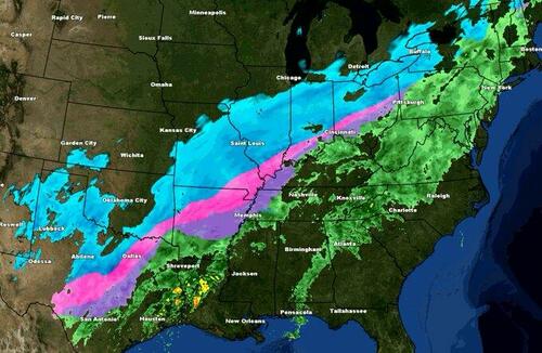
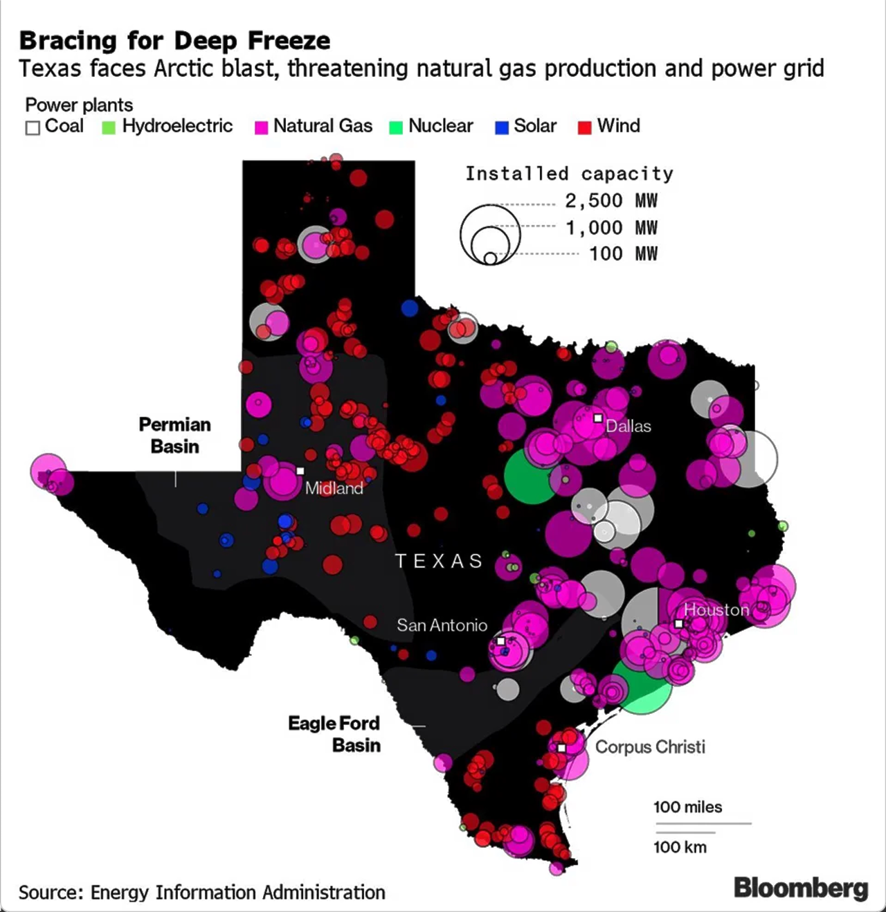
Texas Braces For Cold Snap As NatGas Pipelines Freeze; Power Blackout Concerns Mount
BY TYLER DURDEN
ZERO HEDGE
THURSDAY, FEB 03, 2022 - 03:20 PM
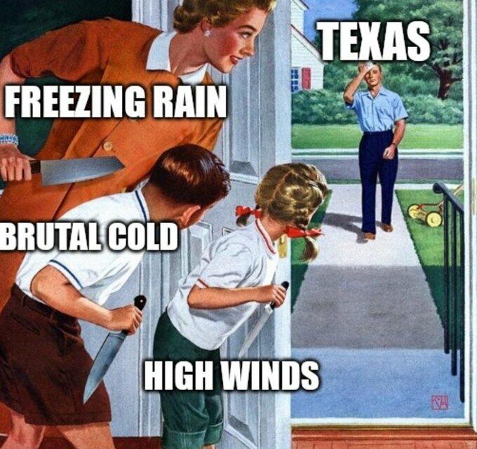
Arctic air has descended into Texas this week as temperatures dive well below freezing. Texas officials have reassured the public numerous times the primary grid operator for Texas, the Electric Reliability Council of Texas (ERCOT), will have the capacity to supply energy to households and businesses as heating demand increases.
"The grid is ready, and the lights will stay on for Texans," Peter Lake, chairman of the Public Utility Commission of Texas, said in a statement Wednesday afternoon. He said earlier in the day that ERCOT "doesn't anticipate any rolling blackouts at all."
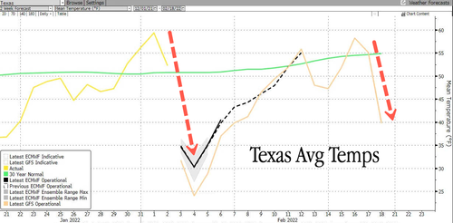
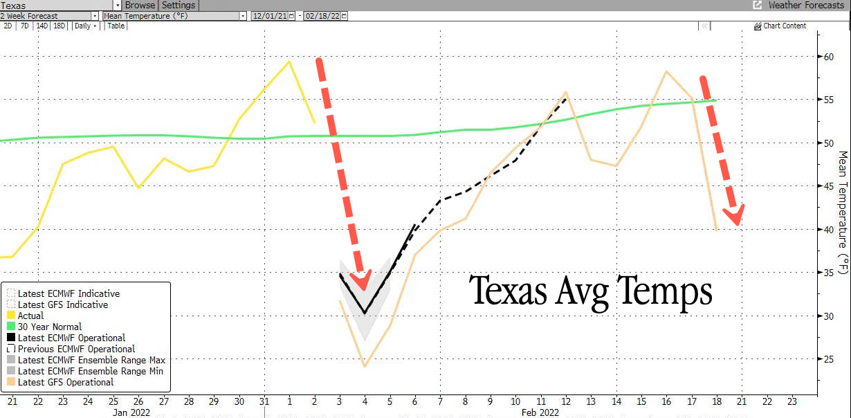
Weather forecasts show a deep freeze in the Lone Star State through Saturday. Average temperatures have dove from 60 degrees Ferinhight on Jan. 31 to as low as 25 degrees Ferinhight on Friday. An ice storm is also hitting the state and will continue through the end of the week.
Brrr it's cold out!
ERCOT anticipates peak demand will be around 72 gigawatts on Friday morning, a level only seen during very hot periods of the summer. The deep freeze is already producing very concerning signs of impending danger.
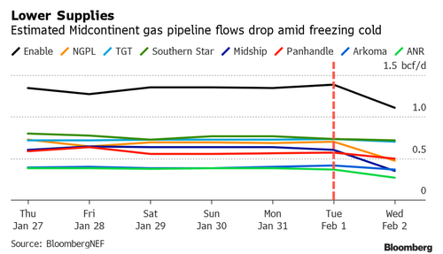
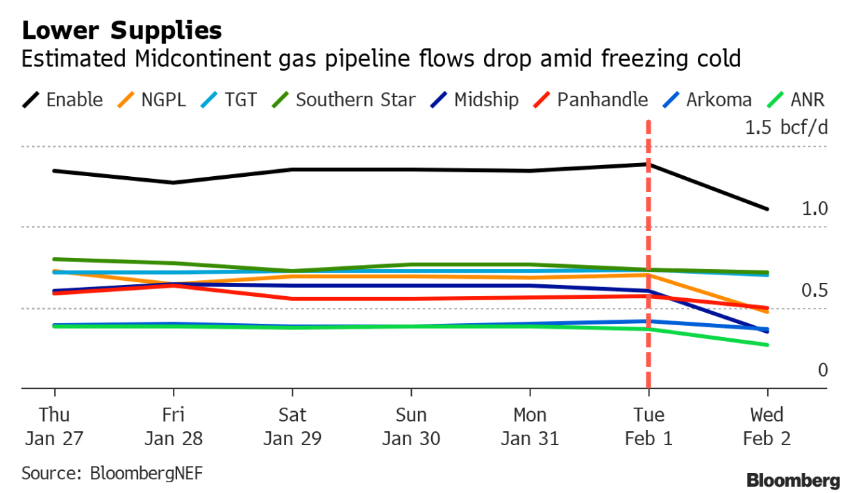
Gas supplies in Oklahoma, the Texas Panhandle, and Arkansas plunged 22% Wednesday from Tuesday as frozen wellheads limited the flow of natgas, according to new data from BloombergNEF.
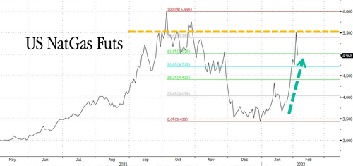
Colder weather and the threat of dwindling supplies are partially responsible for natural gas prices jumping as high as 17% on Wednesday but receding 7% on Thursday morning. Prices topped as high as $5.50/MMBtu yesterday, back to levels not seen in nearly a decade.
"This is just the beginning," said BNEF analyst Jade Patterson. Frozen pipelines could restrict Midcontinent gas supplies through the weekend. As readers may recall, frozen natgas pipelines were one of the primary causes of the energy crisis in Texas last year. If natgas power generation plants can't get fuel, there will be serious issues and risks of blackouts in the Texas.

"This weather system has really strengthened, particularly in the Midwest and in the producing region," said John Kilduff, co-founder of Again Capital LLC. "There is certain to be freeze offs, there is certain to be operational hiccups in terms of transmission and transport via pipelines of gas molecules."
"The combination of increased heating demand and reduced production due to freeze offs will tighten the market through the next two weeks," said Peter Rosenthal, head of power and North American gas at Energy Aspects.
Due to the risk of grid complications, crypto-miner Riot Blockchain Inc. shut down most of its Bitcoin-making operation in Texas this week to conserve electricity. Riot voluntarily began reducing power on Tuesday ahead of the cold snap.
"Whinstone began taking proactive measures to prepare for shutting down its mining operations in response to any demand surges in Ercot," said company spokesperson Trystine Payfer.
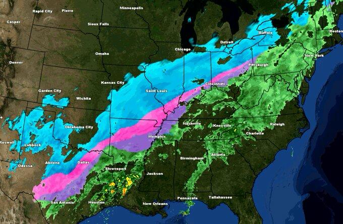
The deep freeze is part of a powerful winter storm traversing the central, eastern, and southern U.S.
The question readers have is if ERCOT can meet demand while preventing pipelines from freezing. If not, a redux of the 2021 energy crisis could be imminent.
Texas Braces For Cold Snap As NatGas Pipelines Freeze; Power Blackout Concerns Mount | ZeroHedge
BY TYLER DURDEN
ZERO HEDGE
THURSDAY, FEB 03, 2022 - 03:20 PM
Arctic air has descended into Texas this week as temperatures dive well below freezing. Texas officials have reassured the public numerous times the primary grid operator for Texas, the Electric Reliability Council of Texas (ERCOT), will have the capacity to supply energy to households and businesses as heating demand increases.
"The grid is ready, and the lights will stay on for Texans," Peter Lake, chairman of the Public Utility Commission of Texas, said in a statement Wednesday afternoon. He said earlier in the day that ERCOT "doesn't anticipate any rolling blackouts at all."
Weather forecasts show a deep freeze in the Lone Star State through Saturday. Average temperatures have dove from 60 degrees Ferinhight on Jan. 31 to as low as 25 degrees Ferinhight on Friday. An ice storm is also hitting the state and will continue through the end of the week.
Brrr it's cold out!
ERCOT anticipates peak demand will be around 72 gigawatts on Friday morning, a level only seen during very hot periods of the summer. The deep freeze is already producing very concerning signs of impending danger.
Gas supplies in Oklahoma, the Texas Panhandle, and Arkansas plunged 22% Wednesday from Tuesday as frozen wellheads limited the flow of natgas, according to new data from BloombergNEF.
Colder weather and the threat of dwindling supplies are partially responsible for natural gas prices jumping as high as 17% on Wednesday but receding 7% on Thursday morning. Prices topped as high as $5.50/MMBtu yesterday, back to levels not seen in nearly a decade.

"This is just the beginning," said BNEF analyst Jade Patterson. Frozen pipelines could restrict Midcontinent gas supplies through the weekend. As readers may recall, frozen natgas pipelines were one of the primary causes of the energy crisis in Texas last year. If natgas power generation plants can't get fuel, there will be serious issues and risks of blackouts in the Texas.
"This weather system has really strengthened, particularly in the Midwest and in the producing region," said John Kilduff, co-founder of Again Capital LLC. "There is certain to be freeze offs, there is certain to be operational hiccups in terms of transmission and transport via pipelines of gas molecules."
"The combination of increased heating demand and reduced production due to freeze offs will tighten the market through the next two weeks," said Peter Rosenthal, head of power and North American gas at Energy Aspects.
Due to the risk of grid complications, crypto-miner Riot Blockchain Inc. shut down most of its Bitcoin-making operation in Texas this week to conserve electricity. Riot voluntarily began reducing power on Tuesday ahead of the cold snap.
"Whinstone began taking proactive measures to prepare for shutting down its mining operations in response to any demand surges in Ercot," said company spokesperson Trystine Payfer.
The deep freeze is part of a powerful winter storm traversing the central, eastern, and southern U.S.
The question readers have is if ERCOT can meet demand while preventing pipelines from freezing. If not, a redux of the 2021 energy crisis could be imminent.
Texas Braces For Cold Snap As NatGas Pipelines Freeze; Power Blackout Concerns Mount | ZeroHedge
northern watch
TB Fanatic

northern watch
TB Fanatic

northern watch
TB Fanatic
nomifyle
TB Fanatic
This and I believe the general public has no clue, I say GSM and they say huh!however, the prevaricators within the AGW Party will of course sidestep this “issue” and instead continue to use localized heatwaves and droughts (that have historically and periodically ALWAYS occurred) to support their lie.
God is good all the time
Judy
northern watch
TB Fanatic
From my email inbox The Old Farmer's Almanac

northern watch
TB Fanatic

alpha
Veteran Member
Freeze Returns To Parts Of Europe-Scandinavia Suffers -35.5C (-31.9F); + Swings Between Extremes Hit The Northeast And Atlantic Canada: Signs Of Low Solar Activity - Electroverse
 Extreme Weather GSM
Freeze Returns To Parts Of Europe–Scandinavia Suffers -35.5C (-31.9F); + Swings Between Extremes Hit The Northeast And Atlantic Canada: Signs Of Low Solar Activity
February 14, 2022 Cap Allon
Freeze Returns To Parts Of Europe–Scandinavia Suffers-35.5C (-31.9F)
Brief but powerful shots of Arctic cold hit parts of Europe over the weekend, particularly the Alps, Czechia, and Scandinavia.
The Winter of 2021-2022 has been a mild one for Central and Western Europe, and while that continues to be the case, periodic punches of polar cold are still managing to break south–the continent’s chill of winter has largely been confined to the East and Southeast, where record-breaking lows and debilitating snows have been buffeting the likes of Turkey since December 2021.
With regards to the weekend’s polar conditions: Amburnex Combe, Switzerland logged a low of -24.8C (-12.6F); Rokytská Slať, Czech Republic saw -18C (-0.4F), plus 115cm (3.8ft) of snow; Austria observed -20C, and 65cm (2.1ft) of snow; while in Scandinavia, Naimakka, Sweden shivered through -35.5C (-31.9F), with Kaukoteino, Norway suffering -35.2C (-31.4F).
On Monday, pockets of anomalous cold will persist in parts of Czechia, Austria, Poland, Slovakia, Ukraine, Romania, Hungary, the Baltic region, Scandinavia, and the Balkans; but as the week progresses, these areas will flip to experiencing anomalous heat, as will the majority of Europe. Central Europe, for example, could see highs upwards of 20C this week, while Portugal/Spain could register 30C (86F)–but rather than an indication of catastrophic anthropogenic global warming, this setup will serve as evidence of the swings between extremes witnessed during times of low solar activity:
And while Europe trends warmer this week, the world as a whole looks set to continue its cooling trend.
Climate Reanalyzer utilizes existing publicly-available datasets and models to give a ‘best guess’ of the global temperature for the day. The Climate Change Institute at the University of Maine is charged with its operations, and, being a mainstream dataset, temperature forecasts tend to run hot. But still, readings have been hovering around the 1979-2000 baseline in recent days, and as of today, Feb 14, ‘the World’ is just 0.1C above the average:
 Global Temperature ‘forecast’ for Mon, Feb 14 [climatereanalyzer.org].
Moreover, January’s observed UAH data put the average global temp of the lower troposphere (where us humans reside) at just 0.03C above the 30-year average. This is down 0.18C from the previous month, and down a substantial 0.68C from the 2016 high:
Earth has been cooling since 2016, in line with low solar activity. Where this cool-down stops is anyone’s guess, but with the sun’s slumber persisting into SC25 –with the past two cycles proving the weakest of the past 200+ years– we likely have a long way left to fall. And that’s not counting NOAA’s forecast for SC26 (late-2020s to early-2040s) which shows all-but ZERO sunspots over the coming decades, a reality, that if it were to play out, would signal the onset of a Grand Solar Minimum proper.
Combined, Solar Cycles 24 and the burgeoning 25 are looking set to be on par with those of the Dalton Minimum (1790-1830) — an era of brutal cold, crop loss, famine, war and powerful Volcanic eruptions. Like the deeper Maunder and Spörer Minimums preceding it, the Dalton brought on a period of lower-than-average global temperatures. The Oberlach Station in Germany, for example, experienced a 2C decline over 20 years, which devastated the country’s food production.
The Year Without a Summer also occurred during the Dalton Minimum — in 1816. It was caused by a combination of already low temperatures plus the aftereffects of the second largest volcanic eruption in 2000 years: Mount Tambora’s VEI 7 on April 10, 1815. The earthquakes and tsunamis that followed that explosion killed tens of thousands of people living on the surrounding Indonesian islands. But in Europe and the U.S., Tambora’s eruption wasn’t of much interest, at least not initially — the news was dominated by the Napoleonic Wars and the Battle of Waterloo on June 18, 1815, in which the Duke of Wellington defeated Napoleon Bonaparte at the expense of 65,000 men. Newspapers were preoccupied with the battle right up until the start of winter in 1815, when the weather turned decidedly ‘wacky’. By 1816, the climate was dominating the headlines when both Spring and then Summer failed to arrive. One Virginia resident recalled, “In June another snowfall came and folks went sleighing. On July 4, water froze in cisterns and snow fell again, with Independence Day celebrants moving inside churches where hearth fires warmed things a mite.” Clothes froze on the line in New England, ice on ponds and lakes was reported in northwestern Pennsylvania in both July and August, and Virginia had frosts in August. The temperature occasionally got into the 90s, but then would drop to nearly freezing in just a few hours. Crops that had managed to sprout were frozen out in early June, replanted, and frozen again in July. Very few crops were actually harvested, and of those that were, the yields were very poor. In turn, food and grain prices skyrocketed — for example, in 1815, oats sold for $0.12 a bushel but by the next year, a bushel would set you back $0.92.
And the story was the same across the world:
The potato crop in Ireland rotted in the ground resulting in widespread starvation. In England, France and Germany wheat crops failed leading to bread shortages and food riots and looting. Northern China was also hard hit with thousands of people starving to death. While in southern Asia, torrential rains triggered a cholera epidemic that killed many more.
The year 1816 went on to earn another, rather more morbid nickname, “Eighteen Hundred and Froze to Death“.
This is the power of cosmic and climatic forcings, and an eerily similar setup is building again today: climate is cyclic, never linear, after-all, and the COLD TIMES appear to be returning. Prepare.
Swings Between Extremes Hit The Northeast And Atlantic Canada
Swings have also been noted in North America of late, particularly in Massachusetts, U.S., and Nova Scotia, Canada.
After Saturday’s out-of-season warmth that fired the mercury into the 50s parts of Massachusetts, highs on Sunday dipped into the 40s before plummeting into the 30s and then 20s into dusk: a “weather roller coaster” is how NWS meteorologist Bill Leatham put it.
More snowfall than expected hit areas like Boston (4.8 inches), and also Rockland, Weymouth, and Lexington (6 inches), with the flakes still coming down overnight Sunday and through Monday morning: “The system tracked closer to us, and provided an extra lift that resulted in more snowfall than we were anticipating,” said Leatham.
This stark flip-flopping infected areas across the Northeast — and following daily record-highs on Saturday, New York City was blasted by a powerful Arctic front on Sunday which delivered a dusting of snow to Manhattan:
And similarly in Nova Scotia, a blast of polar cold is currently hitting the Canadian province just a day after record highs were enjoyed (breaking records from 1981 and 1998).
In response to the frigid outlook, Environment Canada issued public weather alerts for all counties in the province for both Sunday and Monday. Winter storm alerts have been issued for all of Cape Breton, with snowfall alerts in place for mainland Nova Scotia — ECCC is advising that non-essential travel be postponed until conditions improve.
CBC meteorologist Ryan Snoddon said the incoming system will be long in duration, and is arriving in two rounds — the first round moved through Sunday night, with the second set to traverse the area Monday, bringing with it stronger winds.
Snow totals of up to 25cm (10 inches) are expected across Nova Scotia, with 30+cm (12+inches) likely to be seen in eastern areas and Cape Breton. Frigid lows are expected to continue Tuesday and into Wednesday, said Snoddon.
As discussed above, the Sun appears to be slipping into its next Grand Solar Minimum cycle–a multidecadal spell of reduced solar output where the solar disc can be devoid of sunspots for months or even years at a time.
The result on Earth’s climate will be one of violent swings between extremes. Intense bursts of heat will linger in one area, while a teeth-chattering chill will dominate nearby, and then the regions will switch — it is this unpredictable chopping and changing that will hasten the failure of our modern food production systems; crops will fail, on a large scale, and famine could quickly ensue.
Prepare accordingly — learn the facts, relocate if need be and grow your own.
The COLD TIMES are returning, the mid-latitudes are REFREEZING, in line with historically low solar activity, cloud-nucleating Cosmic Rays, and a meridional jet stream flow (among many other forcings, including the impending release of the Beaufort Gyre).
Freeze Returns To Parts Of Europe–Scandinavia Suffers -35.5C (-31.9F); + Swings Between Extremes Hit The Northeast And Atlantic Canada: Signs Of Low Solar Activity
February 14, 2022 Cap Allon
Freeze Returns To Parts Of Europe–Scandinavia Suffers-35.5C (-31.9F)
Brief but powerful shots of Arctic cold hit parts of Europe over the weekend, particularly the Alps, Czechia, and Scandinavia.
The Winter of 2021-2022 has been a mild one for Central and Western Europe, and while that continues to be the case, periodic punches of polar cold are still managing to break south–the continent’s chill of winter has largely been confined to the East and Southeast, where record-breaking lows and debilitating snows have been buffeting the likes of Turkey since December 2021.
With regards to the weekend’s polar conditions: Amburnex Combe, Switzerland logged a low of -24.8C (-12.6F); Rokytská Slať, Czech Republic saw -18C (-0.4F), plus 115cm (3.8ft) of snow; Austria observed -20C, and 65cm (2.1ft) of snow; while in Scandinavia, Naimakka, Sweden shivered through -35.5C (-31.9F), with Kaukoteino, Norway suffering -35.2C (-31.4F).
On Monday, pockets of anomalous cold will persist in parts of Czechia, Austria, Poland, Slovakia, Ukraine, Romania, Hungary, the Baltic region, Scandinavia, and the Balkans; but as the week progresses, these areas will flip to experiencing anomalous heat, as will the majority of Europe. Central Europe, for example, could see highs upwards of 20C this week, while Portugal/Spain could register 30C (86F)–but rather than an indication of catastrophic anthropogenic global warming, this setup will serve as evidence of the swings between extremes witnessed during times of low solar activity:
And while Europe trends warmer this week, the world as a whole looks set to continue its cooling trend.
Climate Reanalyzer utilizes existing publicly-available datasets and models to give a ‘best guess’ of the global temperature for the day. The Climate Change Institute at the University of Maine is charged with its operations, and, being a mainstream dataset, temperature forecasts tend to run hot. But still, readings have been hovering around the 1979-2000 baseline in recent days, and as of today, Feb 14, ‘the World’ is just 0.1C above the average:
 Global Temperature ‘forecast’ for Mon, Feb 14 [climatereanalyzer.org].
Moreover, January’s observed UAH data put the average global temp of the lower troposphere (where us humans reside) at just 0.03C above the 30-year average. This is down 0.18C from the previous month, and down a substantial 0.68C from the 2016 high:
Earth has been cooling since 2016, in line with low solar activity. Where this cool-down stops is anyone’s guess, but with the sun’s slumber persisting into SC25 –with the past two cycles proving the weakest of the past 200+ years– we likely have a long way left to fall. And that’s not counting NOAA’s forecast for SC26 (late-2020s to early-2040s) which shows all-but ZERO sunspots over the coming decades, a reality, that if it were to play out, would signal the onset of a Grand Solar Minimum proper.
Combined, Solar Cycles 24 and the burgeoning 25 are looking set to be on par with those of the Dalton Minimum (1790-1830) — an era of brutal cold, crop loss, famine, war and powerful Volcanic eruptions. Like the deeper Maunder and Spörer Minimums preceding it, the Dalton brought on a period of lower-than-average global temperatures. The Oberlach Station in Germany, for example, experienced a 2C decline over 20 years, which devastated the country’s food production.
The Year Without a Summer also occurred during the Dalton Minimum — in 1816. It was caused by a combination of already low temperatures plus the aftereffects of the second largest volcanic eruption in 2000 years: Mount Tambora’s VEI 7 on April 10, 1815. The earthquakes and tsunamis that followed that explosion killed tens of thousands of people living on the surrounding Indonesian islands. But in Europe and the U.S., Tambora’s eruption wasn’t of much interest, at least not initially — the news was dominated by the Napoleonic Wars and the Battle of Waterloo on June 18, 1815, in which the Duke of Wellington defeated Napoleon Bonaparte at the expense of 65,000 men. Newspapers were preoccupied with the battle right up until the start of winter in 1815, when the weather turned decidedly ‘wacky’. By 1816, the climate was dominating the headlines when both Spring and then Summer failed to arrive. One Virginia resident recalled, “In June another snowfall came and folks went sleighing. On July 4, water froze in cisterns and snow fell again, with Independence Day celebrants moving inside churches where hearth fires warmed things a mite.” Clothes froze on the line in New England, ice on ponds and lakes was reported in northwestern Pennsylvania in both July and August, and Virginia had frosts in August. The temperature occasionally got into the 90s, but then would drop to nearly freezing in just a few hours. Crops that had managed to sprout were frozen out in early June, replanted, and frozen again in July. Very few crops were actually harvested, and of those that were, the yields were very poor. In turn, food and grain prices skyrocketed — for example, in 1815, oats sold for $0.12 a bushel but by the next year, a bushel would set you back $0.92.
And the story was the same across the world:
The potato crop in Ireland rotted in the ground resulting in widespread starvation. In England, France and Germany wheat crops failed leading to bread shortages and food riots and looting. Northern China was also hard hit with thousands of people starving to death. While in southern Asia, torrential rains triggered a cholera epidemic that killed many more.
The year 1816 went on to earn another, rather more morbid nickname, “Eighteen Hundred and Froze to Death“.
This is the power of cosmic and climatic forcings, and an eerily similar setup is building again today: climate is cyclic, never linear, after-all, and the COLD TIMES appear to be returning. Prepare.
Swings Between Extremes Hit The Northeast And Atlantic Canada
Swings have also been noted in North America of late, particularly in Massachusetts, U.S., and Nova Scotia, Canada.
After Saturday’s out-of-season warmth that fired the mercury into the 50s parts of Massachusetts, highs on Sunday dipped into the 40s before plummeting into the 30s and then 20s into dusk: a “weather roller coaster” is how NWS meteorologist Bill Leatham put it.
More snowfall than expected hit areas like Boston (4.8 inches), and also Rockland, Weymouth, and Lexington (6 inches), with the flakes still coming down overnight Sunday and through Monday morning: “The system tracked closer to us, and provided an extra lift that resulted in more snowfall than we were anticipating,” said Leatham.
This stark flip-flopping infected areas across the Northeast — and following daily record-highs on Saturday, New York City was blasted by a powerful Arctic front on Sunday which delivered a dusting of snow to Manhattan:
Central Park magic in the snow … Snowing in Manhattan… #Architect #architecture #WhatAnArchitectDoes #Efabism #centralpark #NYC pic.twitter.com/e4TUTuFZsX
— William J. Martin (@wjmarchitect) February 13, 2022
And similarly in Nova Scotia, a blast of polar cold is currently hitting the Canadian province just a day after record highs were enjoyed (breaking records from 1981 and 1998).
In response to the frigid outlook, Environment Canada issued public weather alerts for all counties in the province for both Sunday and Monday. Winter storm alerts have been issued for all of Cape Breton, with snowfall alerts in place for mainland Nova Scotia — ECCC is advising that non-essential travel be postponed until conditions improve.
CBC meteorologist Ryan Snoddon said the incoming system will be long in duration, and is arriving in two rounds — the first round moved through Sunday night, with the second set to traverse the area Monday, bringing with it stronger winds.
Snow totals of up to 25cm (10 inches) are expected across Nova Scotia, with 30+cm (12+inches) likely to be seen in eastern areas and Cape Breton. Frigid lows are expected to continue Tuesday and into Wednesday, said Snoddon.
As discussed above, the Sun appears to be slipping into its next Grand Solar Minimum cycle–a multidecadal spell of reduced solar output where the solar disc can be devoid of sunspots for months or even years at a time.
The result on Earth’s climate will be one of violent swings between extremes. Intense bursts of heat will linger in one area, while a teeth-chattering chill will dominate nearby, and then the regions will switch — it is this unpredictable chopping and changing that will hasten the failure of our modern food production systems; crops will fail, on a large scale, and famine could quickly ensue.
Prepare accordingly — learn the facts, relocate if need be and grow your own.
The COLD TIMES are returning, the mid-latitudes are REFREEZING, in line with historically low solar activity, cloud-nucleating Cosmic Rays, and a meridional jet stream flow (among many other forcings, including the impending release of the Beaufort Gyre).
Martinhouse
Deceased
Alpha, thank you so much for posting the Electroverse article!
alpha
Veteran Member
https://electroverse.net/canadian-trucks-running-day-and-night-as-nh-snow-extends-higher/
 Articles
Canadian Trucks Running Day And Night To Clear Record-Smashing Snowfall As Northern Hemisphere Snow Mass Pushes Higher
February 15, 2022 Cap Allon
While the words “truckers” and “Canada” evoke a certain imagery these days (of a battle against tyranny), hundreds of dump trucks are embroiled in a different kind of fight right now, one versus the elements, versus the unprecedented accumulations of SNOW.
400 trucks are working to clear the streets of Moncton after a year of record snow continues to besiege the New Brunswick city. The trucks, filled to the brim with powder, are entering the snow dump on Berry Mills Road day and night — in order to make room for more snow.
“So right now we’re averaging about 300 trips per day to the snow dump here alone, and during our peak times that actually gets over 400,” said Austin Henderson, manager of strategic communications for the City of Moncton.
“You can imagine all of that snow is coming from different streets, residential areas throughout the city and it’s coming here so that our crews can have room to clear the sidewalks, widen the streets and get our full network back open.”
January, 2022 saw historic volumes of snow sweep Moncton, and that snow is staying put after more storms hit in February, reports cbc.ca, one of which went on for several days. There is more snow on the ground now than there was during the record-smashing winter of 2015. Tellingly, and following the increasing trend of snowfall witnessed between 2011 and 2015, the city decided to enlarge the snow dump at Berry Mills Road and also to construct another snow-storage facility in the Caledonia area. AGW Party prophesies of “decreasing winter snowfall” have proved catastrophically inaccurate — snow in Moncton has soaed into uncharted territory in recent years:
 The city of Moncton says there is currently more snow on the ground now, than during the heavy snowfall in 2015. (City of Moncton)
And for those claiming this event is localized and not indicative of planet as a whole, no, Northern Hemisphere Snow Mass has also been on a similarly impressive trajectory. Embedded below is peak of the 2020-2021 season, followed by 2021-2022 (to Feb 13) — both reveal readings comfortably above the 1982-2012 average (by as much as 500 Gigatons):
 NH Snow Mass, peaking March 2021 [FMI].
 NH Snow Mass, to Feb 13, 2022 [FMI].
“A lot of residents have noticed that the streets are very narrow and a lot of sidewalks are getting done much more slowly than they usually would be,” continued Henderson. The challenge is the compounded effect of back-to-back storms, and by the time the last few storms rolled through (in late-Jan/early-Feb) the clogging had become highly problematic.


“To even get the sidewalks open or widen the streets we need to get rid of that snow, because otherwise there’s quite literally nowhere for it to go,” said Henderson — and that’s where the snow dump comes in:
 Snow is unloaded at the Moncton snow dump, where a plow packs it in, and a blower comes along and sprays it up to create a snow mountain. (Pierre Fournier/CBC News)
For now, there is still room at the dump, but considering it’s only mid-Feb in a year that has already packed record-snowy punches, Henderson is planning for the fact that it might — these extraordinary circumstances, he added, and the city is taking extra measures to cope.
Despite the reality of unprecedented NH snow, the MSM are still peddling their ‘catastrophic global warming’ claptrap. Just yesterday, the newrepublic.com was asking “How Many Ski Seasons Are Left?” and spuriously claiming that “winter is dying”.
The article cites snow shortages at Sapporo, Japan during last season’s Snow Festival–I presume it was last season’s, because this year Japan has been logging recording-breaking accumulations: Sapporo City’s snow depth had reached 133cm (4.4ft) in early Feb, 2022, which is 1) double its annual average, and 2) the highest 130>cm this early in the season since at least 1946 (solar minimum of cycle 17). Moreover, far heavier falls have accumulated elsewhere, including the 5.6m (18.4ft) in Charmant Hiuchi which made for Japan’s snowiest winter in recorded history:
These are facts that the New Republic either didn’t bother to check, or, worst still, didn’t want you to know about. But thanks to the modern ‘factory’ schooling system, the dutiful masses have been dissuaded from conducting their own research and/or from applying their own logic and principles to their perceived reality — they simply take each and every official agenda as read.
This is ideal for an establishment hellbent on control, but it is the killer of freewill and of mental health. It declasses us humans to the status of sheep: dutiful, easily rounded, led, and ultimately controlled — and the vast majority don’t even see it. Worst still, many people take it a step further: If the fabricated reality laid out before them is one of “crisis” then they become so consumed by it –and in turn passionate (scared)– that they deem it necessary to take to the streets and demand political action to combat said “emergency”. They lose sleep over this constructed materiality, even though it bares no resemblance to actual reality; and furthermore, they fight all those that dare question the narrative, labeling them as heretics/conspiracy theorists.
Despite 4+ decades of ‘catastrophic anthropogenic global warming’, the warmest U.S. winter on record remains that of 1931-32. During this period much of the Mid-Atlantic, Ohio Valley, Great Lakes and Northeast suffered exceptional warmth and very little snow. Modern climate models along with UHI-skewed temperature datasets (the latter with a very poor global coverage) can lay on the dread as much as they want, but in reality, and as per the most reliable data we have (the satellites), a stark cooling has occurred since 2016: Earth’s average temperature is down 0.68C since then, and all indications point to the fall not being over yet, with it atually set to intensifying and compound in line with ever-decreasing solar activity and our planet’s ever-waning magnetic field strength.
This is a forecast, of course — I have no crystal ball.
But things are playing out as expected:
Solar output continues to decrease; Earth’s magnetosphere continues to wane; the global average temperature continues to fall; while the global snow pack continues to rise. What more evidence do folk require in order to ditch the failed AGW hypothesis? But to that point, people are content to place an ideologue above truth: “The masses have never thirsted after truth. They turn aside from evidence that is not to their taste, preferring to deify error, if error seduces them. Whoever can supply them with illusions is easily their master; whoever attempts to destroy their illusions is always their victim” — Gustave Le Bo.
Elsewhere
After its coldest coreless winter on record, Antarctica recently registered its first -50C of the year (on Feb 12).
While in Florida, Gov. Ron DeSantis has asked U.S. Department of Agriculture (USDA) Secretary Tom Vilsack to issue a federal Disaster Declaration for the many counties impacted by the recent record-breaking freezes.
DeSantis had already issued an executive order declaring cold-related states of emergency across 30 counties, but now the Governor is asking the federal government for help to recover the losses incurred, which have been crippling in some areas.
“Florida’s farmers play a key role in our State’s economy and my administration is committed to their recovery from the recent freezing temperatures,” DeSantis said.
The COLD TIMES are returning, the mid-latitudes are REFREEZING, in line with historically low solar activity, cloud-nucleating Cosmic Rays, and a meridional jet stream flow (among many other forcings, including the impending release of the Beaufort Gyre).
Prepare accordingly — learn the facts, relocate if need be and grow your own.
Canadian Trucks Running Day And Night To Clear Record-Smashing Snowfall As Northern Hemisphere Snow Mass Pushes Higher
February 15, 2022 Cap Allon
While the words “truckers” and “Canada” evoke a certain imagery these days (of a battle against tyranny), hundreds of dump trucks are embroiled in a different kind of fight right now, one versus the elements, versus the unprecedented accumulations of SNOW.
400 trucks are working to clear the streets of Moncton after a year of record snow continues to besiege the New Brunswick city. The trucks, filled to the brim with powder, are entering the snow dump on Berry Mills Road day and night — in order to make room for more snow.
“So right now we’re averaging about 300 trips per day to the snow dump here alone, and during our peak times that actually gets over 400,” said Austin Henderson, manager of strategic communications for the City of Moncton.
“You can imagine all of that snow is coming from different streets, residential areas throughout the city and it’s coming here so that our crews can have room to clear the sidewalks, widen the streets and get our full network back open.”
January, 2022 saw historic volumes of snow sweep Moncton, and that snow is staying put after more storms hit in February, reports cbc.ca, one of which went on for several days. There is more snow on the ground now than there was during the record-smashing winter of 2015. Tellingly, and following the increasing trend of snowfall witnessed between 2011 and 2015, the city decided to enlarge the snow dump at Berry Mills Road and also to construct another snow-storage facility in the Caledonia area. AGW Party prophesies of “decreasing winter snowfall” have proved catastrophically inaccurate — snow in Moncton has soaed into uncharted territory in recent years:
 The city of Moncton says there is currently more snow on the ground now, than during the heavy snowfall in 2015. (City of Moncton)
And for those claiming this event is localized and not indicative of planet as a whole, no, Northern Hemisphere Snow Mass has also been on a similarly impressive trajectory. Embedded below is peak of the 2020-2021 season, followed by 2021-2022 (to Feb 13) — both reveal readings comfortably above the 1982-2012 average (by as much as 500 Gigatons):
“A lot of residents have noticed that the streets are very narrow and a lot of sidewalks are getting done much more slowly than they usually would be,” continued Henderson. The challenge is the compounded effect of back-to-back storms, and by the time the last few storms rolled through (in late-Jan/early-Feb) the clogging had become highly problematic.


“To even get the sidewalks open or widen the streets we need to get rid of that snow, because otherwise there’s quite literally nowhere for it to go,” said Henderson — and that’s where the snow dump comes in:
 Snow is unloaded at the Moncton snow dump, where a plow packs it in, and a blower comes along and sprays it up to create a snow mountain. (Pierre Fournier/CBC News)
For now, there is still room at the dump, but considering it’s only mid-Feb in a year that has already packed record-snowy punches, Henderson is planning for the fact that it might — these extraordinary circumstances, he added, and the city is taking extra measures to cope.
The beginning of the #NewBrunswick snow storm. Shoveling to try to stay ahead of the storm. The worst is yet to come. #Moncton #nbstorm #ShareYourWeather @weathernetwork @MurphTWN @NateTWN pic.twitter.com/CTU1QBiR1W
— TC Tom J (@TCTOMJ) February 4, 2022
Despite the reality of unprecedented NH snow, the MSM are still peddling their ‘catastrophic global warming’ claptrap. Just yesterday, the newrepublic.com was asking “How Many Ski Seasons Are Left?” and spuriously claiming that “winter is dying”.
The article cites snow shortages at Sapporo, Japan during last season’s Snow Festival–I presume it was last season’s, because this year Japan has been logging recording-breaking accumulations: Sapporo City’s snow depth had reached 133cm (4.4ft) in early Feb, 2022, which is 1) double its annual average, and 2) the highest 130>cm this early in the season since at least 1946 (solar minimum of cycle 17). Moreover, far heavier falls have accumulated elsewhere, including the 5.6m (18.4ft) in Charmant Hiuchi which made for Japan’s snowiest winter in recorded history:
Heavy #snow in #Japan !#Sapporo had a snow depth of 133 cm yesterday, one of the highest so early in Feb.
560 cm Charmant Hiuchi
550 cm Kiroro Snow W.
530 cm Yudonosan
529 cm Takogura
510 cm Geto Kogen
505 cm Shimooritate
500 cm Seki Onsen
439 cm Sukayu#Niigata @hepomodeler pic.twitter.com/Z8E28EqNC2
— Thierry Goose (@ThierryGooseBC) February 7, 2022
These are facts that the New Republic either didn’t bother to check, or, worst still, didn’t want you to know about. But thanks to the modern ‘factory’ schooling system, the dutiful masses have been dissuaded from conducting their own research and/or from applying their own logic and principles to their perceived reality — they simply take each and every official agenda as read.
This is ideal for an establishment hellbent on control, but it is the killer of freewill and of mental health. It declasses us humans to the status of sheep: dutiful, easily rounded, led, and ultimately controlled — and the vast majority don’t even see it. Worst still, many people take it a step further: If the fabricated reality laid out before them is one of “crisis” then they become so consumed by it –and in turn passionate (scared)– that they deem it necessary to take to the streets and demand political action to combat said “emergency”. They lose sleep over this constructed materiality, even though it bares no resemblance to actual reality; and furthermore, they fight all those that dare question the narrative, labeling them as heretics/conspiracy theorists.
Despite 4+ decades of ‘catastrophic anthropogenic global warming’, the warmest U.S. winter on record remains that of 1931-32. During this period much of the Mid-Atlantic, Ohio Valley, Great Lakes and Northeast suffered exceptional warmth and very little snow. Modern climate models along with UHI-skewed temperature datasets (the latter with a very poor global coverage) can lay on the dread as much as they want, but in reality, and as per the most reliable data we have (the satellites), a stark cooling has occurred since 2016: Earth’s average temperature is down 0.68C since then, and all indications point to the fall not being over yet, with it atually set to intensifying and compound in line with ever-decreasing solar activity and our planet’s ever-waning magnetic field strength.
This is a forecast, of course — I have no crystal ball.
But things are playing out as expected:
Solar output continues to decrease; Earth’s magnetosphere continues to wane; the global average temperature continues to fall; while the global snow pack continues to rise. What more evidence do folk require in order to ditch the failed AGW hypothesis? But to that point, people are content to place an ideologue above truth: “The masses have never thirsted after truth. They turn aside from evidence that is not to their taste, preferring to deify error, if error seduces them. Whoever can supply them with illusions is easily their master; whoever attempts to destroy their illusions is always their victim” — Gustave Le Bo.
Elsewhere
After its coldest coreless winter on record, Antarctica recently registered its first -50C of the year (on Feb 12).
First -50C of the year in #Antartica. On 12 February the Japanese Base of Dome Fuji (Dome F) dropped to -50.1C. Unlike the coastal and Peninsula, The Plateau uses to cool up fast shortafter the summer solstice. pic.twitter.com/h35SsZpNZ5
— Extreme Temperatures Around The World (@extremetemps) February 13, 2022
While in Florida, Gov. Ron DeSantis has asked U.S. Department of Agriculture (USDA) Secretary Tom Vilsack to issue a federal Disaster Declaration for the many counties impacted by the recent record-breaking freezes.
DeSantis had already issued an executive order declaring cold-related states of emergency across 30 counties, but now the Governor is asking the federal government for help to recover the losses incurred, which have been crippling in some areas.
“Florida’s farmers play a key role in our State’s economy and my administration is committed to their recovery from the recent freezing temperatures,” DeSantis said.
The COLD TIMES are returning, the mid-latitudes are REFREEZING, in line with historically low solar activity, cloud-nucleating Cosmic Rays, and a meridional jet stream flow (among many other forcings, including the impending release of the Beaufort Gyre).
Prepare accordingly — learn the facts, relocate if need be and grow your own.
alpha
Veteran Member
Record Cold Valentine’s Day; Great Lakes Ice Sees Monstrous Recovery; Newly Discovered Data Reveals Sea Temperatures At The Great Barrier Reef Haven’t Increased In 150 Years; + Huge Farside CME
Electroverse
 Articles Extreme Weather GSM
Record Cold Valentine’s Day; Great Lakes Ice Sees Monstrous Recovery; Newly Discovered Data Reveals Sea Temperatures At The Great Barrier Reef Haven’t Increased In 150 Years; + Huge Farside CME
February 16, 2022 Cap Allon
Record Cold Valentine’s Day
Several Ontario cities were among the many locales to set new low temperature records on Valentine’s Day, as Arctic air gripped the entire eastern half of North America.
Greater Sudbury logged a low of -30.4C on Monday, breaking its previous record of -28.8C set in 2003; North Bay dipped to -35C, busting its old benchmark of -33.9C set way back in 1943; while Sault Ste. Marie pipped its 1974 record by 0.2C, hitting a new low of -30.8C.
The full list of busted records is exhaustive — Monday’s low temperature anomalies stretched from the edge Greenland all the way down to Florida and southern Mexico:
 GFS 2m Temp Anomalies (C)–the forecast anomalies for Feb 14 [tropicaltidbits.com].
And looking ahead, the remainder of Feb is set to bring more of the same, but to Western and Central regions, too:
 GFS 2m Temperature Anomalies (C) Feb 17 – Feb 28 [tropicaltidbits.com].
The snow will also be noteworthy, particularly this week’s band stretching from northern Texas all the up to New England and into Atlantic Canada:
 GFS Total Snowfall (inches) Feb 16 – March 4 [tropicaltidbits.com].
All this incoming snow will add to the Northern Hemisphere’s Total Snow Mass, which, as of its latest data point (Feb 14), has pushed on to a level some 400 Gigatons above the 1982-2012 average:
 [FMI]
[FMI]
Great Lakes Ice Sees Big Recovery
NOAA’s initial projection calling for “well-below average” Great Lakes ice coverage in 2022 has been tossed, as persistent blasts of Arctic cold have boosted the Lakes’ ice concentration to above the typical range in data stretching back to 1973.
In early January, official projections for Great Lakes ice coverage stood at just 12.3% in 2022; however, following numerous, unexpected bouts of record-low temperatures, ice coverage is now averaging 49.91% (as of Feb 15).
Great Lakes ice doesn’t usually peak until early March, so there’s a way left to run. And referencing the above GFS forecast, it looks like conditions will be beneficial for additional growth, meaning this year will likely wind-up closing well-above the norm.
The lowest year on record for annual maximum coverage was 2002’s 11.8%, while 50% is considered the multidecadal average.
Despite mainstream claims of “catastrophic ice loss”, Earth’s climatic reality is proving difficult to pin down: “We don’t know much about it, mostly because it’s so hard to make observations in ice-covered or wintertime lakes,” said Ayumi Fujisaki-Manome, assistant research scientist with the Cooperative Institute for Great Lakes Research. It stands that the only thing on thin ice is the AGW hypothesis itself — it is surviving on nothing but a whim and a prayer — and its days look numbered.
Newly Discovered Data Reveals Sea Temperatures At The Great Barrier Reef Haven’t Increased In 150 Years
As reported by dailysceptic.org, a 1871 dataset of sea temperatures across the Great Barrier Reef has been compared to measurements today, and no differences were noted, according to by Dr Bill Johnson: “Alarming claims that the East Australian Current has warmed due to global warming are therefore without foundation.”
The SS Governor Blackall, a steamship on a voyage around the Australian east coast, was responsible for taking the 1871 temperatures — hourly measurements were made between 6am and 6pm every day. Recently, this data was recovered and collated by Dr Bill Johnson, a former research scientist at the New South Wales Department of Natural Resources, and after allowing for the considerable seasonal variations across the reef, Dr Johnson concluded that nothing much had changed, that there was no evidence that the system regulating temperature had broken down “or is likely to break down in the future”.
The world’s media is keen to push a different picture, however: The BBC reported back in late-2020 that the Great Barrier Reef had lost half of its coral since 1995, citing a report that blamed “warmer seas driven by climate change”.
But as Professor Peter Ridd explains, a man who has spent 40 years observing the reef, Coral growth rates have, if anything, “increased over the last 100 years” — a reality illustrated by the below graph which uses Australian Institute of Marine Science records:

For more of a deep-dive I suggest you read the dailysceptic.org article in full, which also goes into the suspect goings on between self-aggrandizing reporter Marlowe Hood, a University of Leeds paper calling for “100%” reef mortality if temperatures rise to 2C above pre-industrial levels (with 25% of marine wildlife wiped out even if temps are capped to 1.5C), and a €100,000 donation to Marlow by the Spanish bank BBVA, which is heavily involved in Net Zero finance.
Follow the science…?
Follow the money, more like.
Huge Farside CME
Something just exploded on the farside of the sun–and it was big, reports spaceweather.com.
NASA’s STEREO-A spacecraft recorded a magnificent coronal mass ejection (CME) emerging during the late hours of Feb 15:

STEREO-A also observed a 400km-long plume of plasma emerging from the blast site:

This CME is not directed towards Earth, it being a “farside” explosion; but if such a CME did breach our magnetosphere, it would produce a very strong geomagnetic storm, which in turn would threaten our modern electrical infrastructure (the grid).
“We may have dodged a bullet,” writes Dr Tony Phillips.
Farm Bureau: Record U.S. Potato Prices
USDA’s latest Cold Storage Report reveals the impacts of frigid weather and drought, among other factors, on stores of staple foods. Record prices are expected into 2022 as demand continues to bite into an ever-decreasing supply.
The 2021 numbers are in, and according to the Farm Bureau, the U.S. potato crop was down 2% from 2020 (the fourth consecutive annual decline). This lower supply, combined with strong North American and international processing demand, lifted U.S. seasonal-average potato prices above $10/cwt, up 14% from the previous year.
Drought and cold conditions across large potato-producing states like Washington and Idaho, which account for 55% of U.S. spuds, dropped their production rates by 9% and 7%, respectively. While across the U.S., overall supplies have fallen 5% from last year and 6% from the five-year (2015-2020) average. This picture of dwindling supplies is also visible across the vegetable board:

The COLD TIMES are returning, the mid-latitudes are REFREEZING, in line with historically low solar activity, cloud-nucleating Cosmic Rays, and a meridional jet stream flow (among many other forcings, including the impending release of the Beaufort Gyre).
Prepare accordingly — learn the facts, relocate if need be and grow your own.
Electroverse
Record Cold Valentine’s Day; Great Lakes Ice Sees Monstrous Recovery; Newly Discovered Data Reveals Sea Temperatures At The Great Barrier Reef Haven’t Increased In 150 Years; + Huge Farside CME
February 16, 2022 Cap Allon
Record Cold Valentine’s Day
Several Ontario cities were among the many locales to set new low temperature records on Valentine’s Day, as Arctic air gripped the entire eastern half of North America.
Greater Sudbury logged a low of -30.4C on Monday, breaking its previous record of -28.8C set in 2003; North Bay dipped to -35C, busting its old benchmark of -33.9C set way back in 1943; while Sault Ste. Marie pipped its 1974 record by 0.2C, hitting a new low of -30.8C.
The full list of busted records is exhaustive — Monday’s low temperature anomalies stretched from the edge Greenland all the way down to Florida and southern Mexico:
 GFS 2m Temp Anomalies (C)–the forecast anomalies for Feb 14 [tropicaltidbits.com].
And looking ahead, the remainder of Feb is set to bring more of the same, but to Western and Central regions, too:
 GFS 2m Temperature Anomalies (C) Feb 17 – Feb 28 [tropicaltidbits.com].
The snow will also be noteworthy, particularly this week’s band stretching from northern Texas all the up to New England and into Atlantic Canada:
 GFS Total Snowfall (inches) Feb 16 – March 4 [tropicaltidbits.com].
All this incoming snow will add to the Northern Hemisphere’s Total Snow Mass, which, as of its latest data point (Feb 14), has pushed on to a level some 400 Gigatons above the 1982-2012 average:
Great Lakes Ice Sees Big Recovery
NOAA’s initial projection calling for “well-below average” Great Lakes ice coverage in 2022 has been tossed, as persistent blasts of Arctic cold have boosted the Lakes’ ice concentration to above the typical range in data stretching back to 1973.
In early January, official projections for Great Lakes ice coverage stood at just 12.3% in 2022; however, following numerous, unexpected bouts of record-low temperatures, ice coverage is now averaging 49.91% (as of Feb 15).
Great Lakes ice doesn’t usually peak until early March, so there’s a way left to run. And referencing the above GFS forecast, it looks like conditions will be beneficial for additional growth, meaning this year will likely wind-up closing well-above the norm.
The lowest year on record for annual maximum coverage was 2002’s 11.8%, while 50% is considered the multidecadal average.
Despite mainstream claims of “catastrophic ice loss”, Earth’s climatic reality is proving difficult to pin down: “We don’t know much about it, mostly because it’s so hard to make observations in ice-covered or wintertime lakes,” said Ayumi Fujisaki-Manome, assistant research scientist with the Cooperative Institute for Great Lakes Research. It stands that the only thing on thin ice is the AGW hypothesis itself — it is surviving on nothing but a whim and a prayer — and its days look numbered.
Newly Discovered Data Reveals Sea Temperatures At The Great Barrier Reef Haven’t Increased In 150 Years
As reported by dailysceptic.org, a 1871 dataset of sea temperatures across the Great Barrier Reef has been compared to measurements today, and no differences were noted, according to by Dr Bill Johnson: “Alarming claims that the East Australian Current has warmed due to global warming are therefore without foundation.”
The SS Governor Blackall, a steamship on a voyage around the Australian east coast, was responsible for taking the 1871 temperatures — hourly measurements were made between 6am and 6pm every day. Recently, this data was recovered and collated by Dr Bill Johnson, a former research scientist at the New South Wales Department of Natural Resources, and after allowing for the considerable seasonal variations across the reef, Dr Johnson concluded that nothing much had changed, that there was no evidence that the system regulating temperature had broken down “or is likely to break down in the future”.
The world’s media is keen to push a different picture, however: The BBC reported back in late-2020 that the Great Barrier Reef had lost half of its coral since 1995, citing a report that blamed “warmer seas driven by climate change”.
But as Professor Peter Ridd explains, a man who has spent 40 years observing the reef, Coral growth rates have, if anything, “increased over the last 100 years” — a reality illustrated by the below graph which uses Australian Institute of Marine Science records:

For more of a deep-dive I suggest you read the dailysceptic.org article in full, which also goes into the suspect goings on between self-aggrandizing reporter Marlowe Hood, a University of Leeds paper calling for “100%” reef mortality if temperatures rise to 2C above pre-industrial levels (with 25% of marine wildlife wiped out even if temps are capped to 1.5C), and a €100,000 donation to Marlow by the Spanish bank BBVA, which is heavily involved in Net Zero finance.
Follow the science…?
Follow the money, more like.
Huge Farside CME
Something just exploded on the farside of the sun–and it was big, reports spaceweather.com.
NASA’s STEREO-A spacecraft recorded a magnificent coronal mass ejection (CME) emerging during the late hours of Feb 15:

STEREO-A also observed a 400km-long plume of plasma emerging from the blast site:

This CME is not directed towards Earth, it being a “farside” explosion; but if such a CME did breach our magnetosphere, it would produce a very strong geomagnetic storm, which in turn would threaten our modern electrical infrastructure (the grid).
“We may have dodged a bullet,” writes Dr Tony Phillips.
Farm Bureau: Record U.S. Potato Prices
USDA’s latest Cold Storage Report reveals the impacts of frigid weather and drought, among other factors, on stores of staple foods. Record prices are expected into 2022 as demand continues to bite into an ever-decreasing supply.
The 2021 numbers are in, and according to the Farm Bureau, the U.S. potato crop was down 2% from 2020 (the fourth consecutive annual decline). This lower supply, combined with strong North American and international processing demand, lifted U.S. seasonal-average potato prices above $10/cwt, up 14% from the previous year.
Drought and cold conditions across large potato-producing states like Washington and Idaho, which account for 55% of U.S. spuds, dropped their production rates by 9% and 7%, respectively. While across the U.S., overall supplies have fallen 5% from last year and 6% from the five-year (2015-2020) average. This picture of dwindling supplies is also visible across the vegetable board:
The COLD TIMES are returning, the mid-latitudes are REFREEZING, in line with historically low solar activity, cloud-nucleating Cosmic Rays, and a meridional jet stream flow (among many other forcings, including the impending release of the Beaufort Gyre).
Prepare accordingly — learn the facts, relocate if need be and grow your own.
alpha
Veteran Member
Alpha, thank you so much for posting the Electroverse article!
Just trying to fill in during TxGal's absence...
I am on my way home from the North Slope today.
Last two weeks up there are the longest bitter cold stretch I remember in 10 years I have been working there. We hit 54 below one night. We have been pretty much in cold weather (36 below and colder) shut down, with a lot of below minus 40 days, for the past week and half. Pretty much anything with exposed hydraulic lines does not operate past 36 below. People not a issue. They don’t want any spills or leaks on the tundra.
Having lived in the interior of AK for 20 years I saw -50 -60 most every year, Jan-Feb and -74 once but not on the North Slope.
Last edited:
Martinhouse
Deceased
Again, Alpha, much appreciated! I hope TxGal is doing okay.
Ktrapper, that is interesting! Horrible, but interesting!
Ktrapper, that is interesting! Horrible, but interesting!
TxGal
Day by day
Again, Alpha, much appreciated! I hope TxGal is doing okay.
Ktrapper, that is interesting! Horrible, but interesting!
Hey Martinhouse! I'm hanging in there, things are going well, and I'm popping in here and there...mostly in the BS area with everything going on.
Martinhouse
Deceased
Oh, thanks for dropping by! Nice to know you're okay.
alpha
Veteran Member
Electroverse
Bureau Of Meteorology’s Annual Report Doesn’t Link Humans To Climate Change, Also Shows Australia Is Cooling
February 17, 2022 Cap Allon
 Articles GSM
The Australian Bureau of Meteorology’s latest annual climate report doesn’t link human activity to global warming (though the agency does continue to insinuate it) — and thanks to the dogged efforts of no-nonsense Aussie politician Malcolm Roberts, the BOM has admitted as much.
Roberts writes: Whenever I ask politicians to prove climate change is real and caused by humans they always point to the Bureau of Meteorology report, State of the Climate. But the report only publishes temperatures and observations, it doesn’t link any changes with carbon dioxide created by humans. The BOM admits in questioning (linked below) that the report itself simply confirms that the climate is variable without attributing a cause for it. If this is the case, why do politicians and so-called experts keep claiming this report proves carbon dioxide from humans is a danger and must be cut?
Moreover, the last two annual climate reports reveal the Aussies continent has actual COOLED, yet the agency has slyly tweaked the wording and date-ranges used in its reports so as not to draw attention to it — they are lying by omission.
This was noticed by Jennifer Marohasy, an Australian scientist and author. The below text is lifted from her website:
At the beginning of each year, normally within the first week, the Australian Bureau of Meteorology release their annual climate statement for the previous year with comment about how much hotter it is relative to temperatures back to 1910.
Two years ago (Jan 9, 2020) it was reported in the Sydney Morning Herald: We’ve seen clear trends in maximum, minimum and average temperatures across Australia … the country had warmed about 1.4 degrees since 1910, most of it since 1950. Last year (Jan 8, 2021) the BOM’s annual climate statement included comment that Australia’s climate has warmed on average by 1.44 degrees Celsius since records began in 1910. And now this year (Feb 8, 2022) the annual climate statement includes comment that Australia’s climate has warmed on averaged 1.47 degrees Celsius between when national records began in 1910 and 2020. Though interestingly, it was reported as 1.4 in the Sydney Morning Herald a month earlier.
In fact, temperatures in the official ACORN-SAT database have been coming down for the last two years, but the management at the Australian Bureau of Meteorology don’t seem able to acknowledge this reality.
To be clear, the quoted warming of 1.4 °C could relate to the period 1910 to 2019 (inclusive), with 1.44 °C being the value based on ACORN-SAT version 2.1 and 1.47 °C being the value based on ACORN-SAT version 2.2. This is the opinion of Chris Gillham, who maintains a wonderful resource at waclimate.net. He has calculated that ACORN-SAT 2.2’s mean temperature to be 0.77 °C warmer in 2021 than in 1910, with unadjusted (raw) historical values being just 0.25 °C warmer.
The Bureau’s wording is ambiguous — ‘when national records began in 1910 and 2020’ could mean to the beginning, or end, of 2020 — the wording is ambiguous enough that officialdom might not be technically wrong, and the average person might not realize that they are being dubbed out of two years of data: the last two years of data!
The alternative explanation, which I’m giving in this update (Feb 12, 2022), is that the 1.4 is actually the linear rate of warming. It is more normally calculated as a rate per year (0.0133) or per hundred years (1.33), but can be calculated as 1.49 °C for the period 1910 to 2021. Using just the ACORN-SAT values to the end of 2020, the value is 1.47, and to the end of 2019 1.45. The rate is continuing to increase because while the last two years have been cooler, considering the values back to 1910 in the ACORN-SAT database, the last two years are on average warmer.
Australia is beginning to cool, in line with the rest of the planet: 2021 was the continent’s coldest year in nearly a decade. The powers that be are lying to us, lying by omission. It stands that if no agenda was in play, and government scientists were led purely by the data without bias, then there would be no issue with them openly communicating this cooling data with us — a trend which began globally in 2016:

The COLD TIMES appear to be returning, the mid-latitudes REFREEZING, in line with historically low solar activity, cloud-nucleating Cosmic Rays, and a meridional jet stream flow (among many other forcings, including the impending release of the Beaufort Gyre).
Prepare accordingly — learn the facts, relocate if need be and grow your own.
Bureau Of Meteorology’s Annual Report Doesn’t Link Humans To Climate Change, Also Shows Australia Is Cooling
February 17, 2022 Cap Allon
The Australian Bureau of Meteorology’s latest annual climate report doesn’t link human activity to global warming (though the agency does continue to insinuate it) — and thanks to the dogged efforts of no-nonsense Aussie politician Malcolm Roberts, the BOM has admitted as much.
Roberts writes: Whenever I ask politicians to prove climate change is real and caused by humans they always point to the Bureau of Meteorology report, State of the Climate. But the report only publishes temperatures and observations, it doesn’t link any changes with carbon dioxide created by humans. The BOM admits in questioning (linked below) that the report itself simply confirms that the climate is variable without attributing a cause for it. If this is the case, why do politicians and so-called experts keep claiming this report proves carbon dioxide from humans is a danger and must be cut?
Moreover, the last two annual climate reports reveal the Aussies continent has actual COOLED, yet the agency has slyly tweaked the wording and date-ranges used in its reports so as not to draw attention to it — they are lying by omission.
This was noticed by Jennifer Marohasy, an Australian scientist and author. The below text is lifted from her website:
At the beginning of each year, normally within the first week, the Australian Bureau of Meteorology release their annual climate statement for the previous year with comment about how much hotter it is relative to temperatures back to 1910.
Two years ago (Jan 9, 2020) it was reported in the Sydney Morning Herald: We’ve seen clear trends in maximum, minimum and average temperatures across Australia … the country had warmed about 1.4 degrees since 1910, most of it since 1950. Last year (Jan 8, 2021) the BOM’s annual climate statement included comment that Australia’s climate has warmed on average by 1.44 degrees Celsius since records began in 1910. And now this year (Feb 8, 2022) the annual climate statement includes comment that Australia’s climate has warmed on averaged 1.47 degrees Celsius between when national records began in 1910 and 2020. Though interestingly, it was reported as 1.4 in the Sydney Morning Herald a month earlier.
In fact, temperatures in the official ACORN-SAT database have been coming down for the last two years, but the management at the Australian Bureau of Meteorology don’t seem able to acknowledge this reality.
To be clear, the quoted warming of 1.4 °C could relate to the period 1910 to 2019 (inclusive), with 1.44 °C being the value based on ACORN-SAT version 2.1 and 1.47 °C being the value based on ACORN-SAT version 2.2. This is the opinion of Chris Gillham, who maintains a wonderful resource at waclimate.net. He has calculated that ACORN-SAT 2.2’s mean temperature to be 0.77 °C warmer in 2021 than in 1910, with unadjusted (raw) historical values being just 0.25 °C warmer.
The Bureau’s wording is ambiguous — ‘when national records began in 1910 and 2020’ could mean to the beginning, or end, of 2020 — the wording is ambiguous enough that officialdom might not be technically wrong, and the average person might not realize that they are being dubbed out of two years of data: the last two years of data!
The alternative explanation, which I’m giving in this update (Feb 12, 2022), is that the 1.4 is actually the linear rate of warming. It is more normally calculated as a rate per year (0.0133) or per hundred years (1.33), but can be calculated as 1.49 °C for the period 1910 to 2021. Using just the ACORN-SAT values to the end of 2020, the value is 1.47, and to the end of 2019 1.45. The rate is continuing to increase because while the last two years have been cooler, considering the values back to 1910 in the ACORN-SAT database, the last two years are on average warmer.
Australia is beginning to cool, in line with the rest of the planet: 2021 was the continent’s coldest year in nearly a decade. The powers that be are lying to us, lying by omission. It stands that if no agenda was in play, and government scientists were led purely by the data without bias, then there would be no issue with them openly communicating this cooling data with us — a trend which began globally in 2016:
The COLD TIMES appear to be returning, the mid-latitudes REFREEZING, in line with historically low solar activity, cloud-nucleating Cosmic Rays, and a meridional jet stream flow (among many other forcings, including the impending release of the Beaufort Gyre).
Prepare accordingly — learn the facts, relocate if need be and grow your own.
alpha
Veteran Member
Sorry I'm late... sick dog to deal with.
Electroverse
 Extreme Weather GSM
Kansas City Breaks 129-Year-Old Snowfall Record; Denver Off To Its Snowiest Start To A Year On Record; + Historic Accumulations Continue To Build In Japan
February 18, 2022 Cap Allon
Kansas City Breaks 129-Year-Old Snowfall Record
As the snow continues to settle in the Kansas City area, NWS data confirms KC busted a century-old record on Feb 17.
An official total of 7 inches had accumulated in the City on Thursday, a reading that broke the previous daily snowfall record of 6 inches set way back in 1893 during the Centennial Minimum.
As reported by local news outlets, the heavy snow led to the closures of schools, businesses and religious services, with multiple school districts canceling classes Friday, too, after the metro area received as much as 10 inches.
Denver Off To Its Snowiest Start To A Year On Record
At the end of 2021, mainstream media outlets were all-too keen to blame Denver’s lack of snow on global climate heating change. Activists reporters were angrily shaking their fists at the skies and yelling “damn you carbon dioxide!”
As of mid-February, however, the story of Denver’s snow has flipped 180, yet, predictably, there’s barely a peep from the MSM.
Denver hasn’t seen a week without snow starting Dec 31, 2021–when 5 inches accumulated. And from Jan 1 – Feb 16, the area has picked up more than 32 inches of snow at its official Central Park weather station, making for the snowiest start to a year in the city’s history books, which date back to the late 1800s.
All of this snow (double the usual precipitation since Dec 30) is also easing Denver’s drought.
On Thursday, the official drought monitor improved the needle from ‘severe’ drought to a ‘moderate’ one–and that doesn’t even count the precipitation from the most recent storm. Crisis averted, activist reporters — don’t you feel silly.
Looking ahead, Denver, as well as North America as a whole, can expect more of the same over the next 10 days.
The final half of February will have a sting in its tail, with widespread Arctic air masses descending down:
 GFS 2m Temperature Anomalies (C) Feb 18 – Feb 28 [tropicaltidbits.com].
 GFS Total Snowfall (inches) Feb 18 – Feb 28 [tropicaltidbits.com].
Historic Accumulations Continue To Build In Japan
In what’s already been a historically snowy winter for East Asia, prefectures along the Sea of Japan coast have been receiving more record totals this week, with Japan’s Meteorological Agency (JMA) warning of even more unprecedented falls to come.
The heavy snowfall is due to an intense a low-pressure system traversing the Sea of Japan where it is meeting a brutally cold air mass — record-breaking low temperatures have been noted in the Tohoku and Chugoku regions, among others, Fuji TV reported.
While the nation’s “snow monsters” have been particularly impressive this year:
According to JMA data, by noon Thursday, 64 cm (25.2 inches) of snow had settled on Ono City in Fukui Prefecture, with 63 cm (24.8 inches) accumulating Shirakawa City in Gifu Prefecture — both new records. The agency added that the heavy snow was expected to continue Friday, too, with the Hokuriku and Tokai regions forecast a further 60cm (23.6 inches).
The Fire and Disaster Management Agency and local police officials are urging residents in areas where there is heavy snow to exercise caution when clearing the roof — a record-high number of people have been clearing snow this season.
The snow has been truly historic — among a seemingly never-ending list of new daily and monthly records, a host of all-time benchmarks have also been falling, including in Esashi, Uwano-kogen, and Noheji:
And I’ll close with another look at that Northern Hemisphere Total Snow Mass chart, which speaks for itself:
 [FMI]
[FMI]
“Snowfalls are just a thing of the past” — the AGW narrative.
The COLD TIMES are returning, the mid-latitudes are REFREEZING, in line with historically low solar activity, cloud-nucleating Cosmic Rays, and a meridional jet stream flow (among many other forcings, including the impending release of the Beaufort Gyre).
Prepare accordingly — learn the facts, relocate if need be, and grow your own.
Electroverse
Kansas City Breaks 129-Year-Old Snowfall Record; Denver Off To Its Snowiest Start To A Year On Record; + Historic Accumulations Continue To Build In Japan
February 18, 2022 Cap Allon
Kansas City Breaks 129-Year-Old Snowfall Record
As the snow continues to settle in the Kansas City area, NWS data confirms KC busted a century-old record on Feb 17.
An official total of 7 inches had accumulated in the City on Thursday, a reading that broke the previous daily snowfall record of 6 inches set way back in 1893 during the Centennial Minimum.
Snow is done at Kansas City (MCI) and the record total for the day is 7.0" breaking the old daily record of 6.0" set back in 1893.
— NWS Kansas City (@NWSKansasCity) February 17, 2022
As reported by local news outlets, the heavy snow led to the closures of schools, businesses and religious services, with multiple school districts canceling classes Friday, too, after the metro area received as much as 10 inches.
Denver Off To Its Snowiest Start To A Year On Record
At the end of 2021, mainstream media outlets were all-too keen to blame Denver’s lack of snow on global climate heating change. Activists reporters were angrily shaking their fists at the skies and yelling “damn you carbon dioxide!”
As of mid-February, however, the story of Denver’s snow has flipped 180, yet, predictably, there’s barely a peep from the MSM.
Denver hasn’t seen a week without snow starting Dec 31, 2021–when 5 inches accumulated. And from Jan 1 – Feb 16, the area has picked up more than 32 inches of snow at its official Central Park weather station, making for the snowiest start to a year in the city’s history books, which date back to the late 1800s.
Coming down in south Denver
— Kerrin Jeromin (@KerrinJeromin) February 17, 2022
All of this snow (double the usual precipitation since Dec 30) is also easing Denver’s drought.
On Thursday, the official drought monitor improved the needle from ‘severe’ drought to a ‘moderate’ one–and that doesn’t even count the precipitation from the most recent storm. Crisis averted, activist reporters — don’t you feel silly.
snow snow snow snow snow snow snow snow snow snow snow snow snow snow snow snow snow snow snow snow snow snow snow snow snow snow snow snow!
— Denver Snow ❄❄❄ (@denversnow) February 11, 2022
Looking ahead, Denver, as well as North America as a whole, can expect more of the same over the next 10 days.
The final half of February will have a sting in its tail, with widespread Arctic air masses descending down:
 GFS Total Snowfall (inches) Feb 18 – Feb 28 [tropicaltidbits.com].
Historic Accumulations Continue To Build In Japan
In what’s already been a historically snowy winter for East Asia, prefectures along the Sea of Japan coast have been receiving more record totals this week, with Japan’s Meteorological Agency (JMA) warning of even more unprecedented falls to come.
The heavy snowfall is due to an intense a low-pressure system traversing the Sea of Japan where it is meeting a brutally cold air mass — record-breaking low temperatures have been noted in the Tohoku and Chugoku regions, among others, Fuji TV reported.
While the nation’s “snow monsters” have been particularly impressive this year:
A #sea of surreal "#snow monsters" appears every #winter in #Japan. Amazing
pic.twitter.com/81Vvu7QuM4
— Auron (@auron83591234) February 16, 2022
According to JMA data, by noon Thursday, 64 cm (25.2 inches) of snow had settled on Ono City in Fukui Prefecture, with 63 cm (24.8 inches) accumulating Shirakawa City in Gifu Prefecture — both new records. The agency added that the heavy snow was expected to continue Friday, too, with the Hokuriku and Tokai regions forecast a further 60cm (23.6 inches).
The Fire and Disaster Management Agency and local police officials are urging residents in areas where there is heavy snow to exercise caution when clearing the roof — a record-high number of people have been clearing snow this season.
Snow has blanketed areas along the Sea of Japan coastline, and weather officials caution there could be another heavy dump on Friday. pic.twitter.com/psN7g9JTOn
— NHK WORLD News (@NHKWORLD_News) February 17, 2022
The snow has been truly historic — among a seemingly never-ending list of new daily and monthly records, a host of all-time benchmarks have also been falling, including in Esashi, Uwano-kogen, and Noheji:
An intense low-pressure system has been spinning near Japan, dumping record-breaking intense #snow. More records may be broken into Friday.
It's the same system that dropped heavy snow over Beijing, disrupting the Olympic games on Sundaypic.twitter.com/BHdrYy8iWO
— Sayaka Mori (@sayakasofiamori) February 17, 2022
Record-shattering heavy #snow has hit parts of Japan. #Sapporo had 60cm of snow in 24 hours (Sat-Sun) making it the heaviest since records started in 1999. All trains to and from JR Sapporo Station have been suspended Monday pic.twitter.com/H8IX54eNga
— Sayaka Mori (@sayakasofiamori) February 7, 2022
And I’ll close with another look at that Northern Hemisphere Total Snow Mass chart, which speaks for itself:
“Snowfalls are just a thing of the past” — the AGW narrative.
The COLD TIMES are returning, the mid-latitudes are REFREEZING, in line with historically low solar activity, cloud-nucleating Cosmic Rays, and a meridional jet stream flow (among many other forcings, including the impending release of the Beaufort Gyre).
Prepare accordingly — learn the facts, relocate if need be, and grow your own.

crossbowboy
Certifiable
Drudge has an article up about February's activity.
2 potential X-class CME's were recently observed, eminating from the far side.
Those spots will be facing us soon.
2 potential X-class CME's were recently observed, eminating from the far side.
Those spots will be facing us soon.
northern watch
TB Fanatic
US Western Megadrought Worst In 1,200 Years, Scientist Warn
BY TYLER DURDEN
ZERO HEDGE
FRIDAY, FEB 18, 2022 - 05:20 PM
Images of dry lake beds, scorched forests and charred buildings, and drought-stricken farmland from the American West have been published in newspapers worldwide as a megadrought intensifies. Many have wondered just how severe the current drought is, and perhaps, that question can be answered in a new study published in the journal Nature Climate Change.
A new peer-reviewed study titled "Rapid intensification of the emerging southwestern North American megadrought in 2020–2021" says the last 22-year dry period is the worst since the Vikings and Mayans ruled parts of the world, or about 1,200 years ago.

Park used tree-ring records to reconstruct summer soil moisture content across centuries and allowed the researcher to believe the current low soil moisture is on par with moisture dating back to the year 800. He also said the conditions would likely persist through 2022.
We have published countless weather notes and the state of the drought in the western half of the US for years. One of the most damning pictures we've reported is Great Salt Lake's progression of dwindling water levels over the last 35 years.
The situation has been worsening over the last few years as several major reservoirs are quickly drying up, forcing people to evacuate their boats and causing hydroelectric plants to shutter due to not having enough water to spin turbines.
Here are some of those images of dried-up lake beds.


According to data from the US Drought Monitor, the current state of the western half of the US is under a severe drought.

An unrelenting megadrought that is drying up lakes should be a major concern to lakefront homeowners who still have water left -- maybe now is the time to sell before your oasis transforms into a desert.
US Western Megadrought Worst In 1,200 Years, Scientist Warn | ZeroHedge
BY TYLER DURDEN
ZERO HEDGE
FRIDAY, FEB 18, 2022 - 05:20 PM
Images of dry lake beds, scorched forests and charred buildings, and drought-stricken farmland from the American West have been published in newspapers worldwide as a megadrought intensifies. Many have wondered just how severe the current drought is, and perhaps, that question can be answered in a new study published in the journal Nature Climate Change.
A new peer-reviewed study titled "Rapid intensification of the emerging southwestern North American megadrought in 2020–2021" says the last 22-year dry period is the worst since the Vikings and Mayans ruled parts of the world, or about 1,200 years ago.
"Anyone who has been paying attention knows that the west has been dry for most of the last couple decades," Park Williams, a climate scientist at the University of California and the study's lead author, told the Guardian.
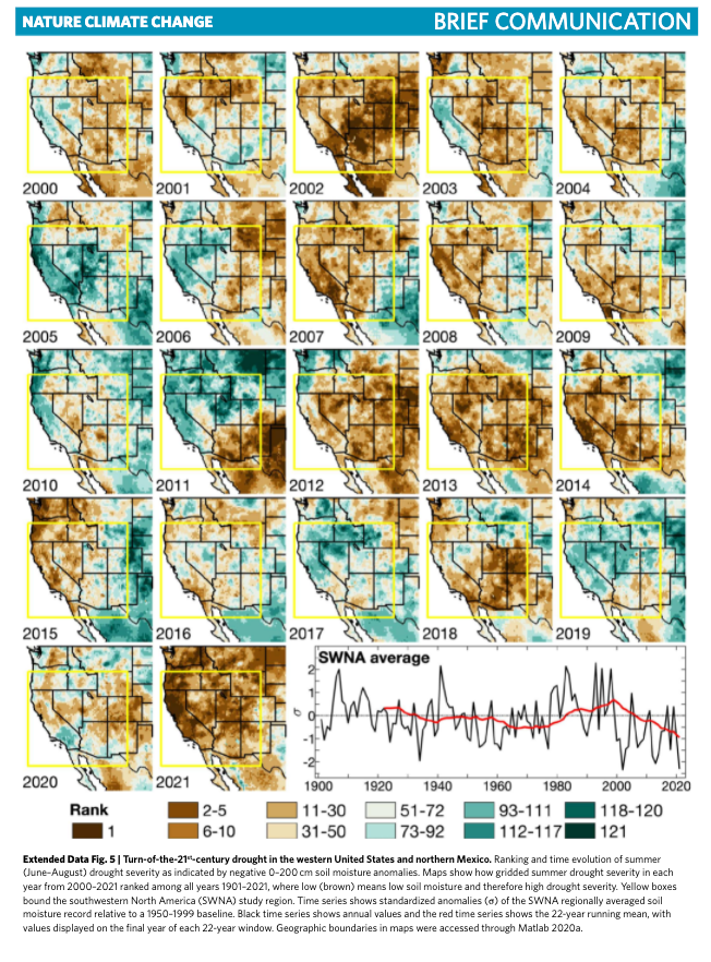
Park used tree-ring records to reconstruct summer soil moisture content across centuries and allowed the researcher to believe the current low soil moisture is on par with moisture dating back to the year 800. He also said the conditions would likely persist through 2022.
"Rather than starting to die away after wet years in 2017 and 2019, the 2000s drought has ramped up with authority in 2020-2021, making clear that it's now as strong as it ever was," Park said, adding "there is evidence that the 2000s drought is starting to relent."
We have published countless weather notes and the state of the drought in the western half of the US for years. One of the most damning pictures we've reported is Great Salt Lake's progression of dwindling water levels over the last 35 years.

The situation has been worsening over the last few years as several major reservoirs are quickly drying up, forcing people to evacuate their boats and causing hydroelectric plants to shutter due to not having enough water to spin turbines.
Here are some of those images of dried-up lake beds.
According to data from the US Drought Monitor, the current state of the western half of the US is under a severe drought.
An unrelenting megadrought that is drying up lakes should be a major concern to lakefront homeowners who still have water left -- maybe now is the time to sell before your oasis transforms into a desert.
US Western Megadrought Worst In 1,200 Years, Scientist Warn | ZeroHedge
Last edited:
northern watch
TB Fanatic
It looks like the High Plains are going to experience Dust Storms again. Texas and Oklahoma do not look good.

Last edited:
northern watch
TB Fanatic

northern watch
TB Fanatic

jed turtle
a brother in the Lord
Speaking of which, this just showed up in the email from Clif High talking about February 19 (today...):Glad you could drop by Txgal!
looks like the future has arrived. Between the canadian truck convoy stopping the flow of Trade and the poor weather affecting the world’s harvests, and rampaging inflation, looks like the big paradigm shift is about to commence. I can hardly wait to see what happens next...
Comutare
northern watch
TB Fanatic

alpha
Veteran Member
Electroverse
Documenting Earth Changes during the next GSM and Pole Shift
 Extreme Weather GSM
Fierce Cold Wave Sweeps East Asia, Chinese City Sees First Snow Since 1893; + “Dangerously Cold Temperatures” To Hit U.S. And Canada
February 21, 2022 Cap Allon
Fierce Cold Wave Sweeps East Asia, Chinese City Sees First Snow Since 1893
A powerful Arctic front has engulfed the majority if Eastern Asia of late. Low temperature records are being toppled, as are snowfall benchmarks–particularity in Japan (as noted lat last week), but also in China…
The Chinese city of Xiamen, Fujian province (24N) witnessed extremely rare flakes on Sunday morning — it was the first time the city had seen snow in 129 years, since the January of 1893 (the Centennial Minimum). Snow settled ACROSS Southern China over the weekend, breaking many longstanding records: “It’s a subtropical climate!”, tweeted @SamJermy. “Really odd occurrence.”
Elsewhere in East Asia, the mercury dropped to 0.6C (33F) on the Tai Moh Shan Peak (955m) in Hong Kong; 2.9C (37F) on the Nong Ping (593m); while in Vietnam, to the south, rare snow has hit Mount Mao Son (1600m) in Lang Son Province after temperatures dropped to -0.4C (31F).


Sunday also saw some remarkably low daily maximum temperatures: Ngong Ping, Hong Kong reached just 4.6C (40F); Lang Son, Vietnam, climbed to just 6.6C (44F); Viengsay, Laos logged 7.5C (45.5F); and even Nong Khai, Thailand, saw highs of just 18.5C (65F) as Arctic air descended all the way down into the Gulf of Thailand.
Looking ahead, Eastern Asia’s freeze isn’t set to abate anytime soon, meaning additional low temp records are under threat:
 GFS 2m Temperature Anomalies (C) to Feb 23 [tropicaltidbits.com].
Likewise, so are the benchmarks for snow:
 GFS Total Snowfall (inches) Feb 21 – March 9 [tropicaltidbits.com].
Also note the accumulations set to build in Western Japan during what has already been a historically snowy winter. In fact, heavy snow is, as of Monday, causing whiteout conditions in Hokkaido as a “bomb cyclone” combines with exceptionally frigid polar air:
“Dangerously Cold Temperatures” To Hit U.S. And Canada
An Arctic front continues to push deeper and deeper into the CONUS dragging in frigid air behind it — many local media outlets, including krtv.com and ksal.com, are calling the incoming temperatures “dangerously cold”.
After a few days of unseasonably mild temperatures, unseasonable cold is back in play–another example of the swings between extremes prevalent during times of historically low solar activity (such as we’re experiencing now).
According to the National Weather Service, the fierce chill, which began sweeping northern states, such as Montana, on Sunday, will drop down into the Midwestern U.S. Monday night. Overnight lows in Salina, central Kansas, for example, are forecast to break records Tuesday morning “as a dangerously cold arctic air mass settles over the area,” reports ksal.com — Tuesday’s low in Salina is forecast to be 2 or 3 degrees F, with the city’s record for Feb 22 currently the 3F set back in 1911 (solar minimum of cycle 14, during the Centennial Minimum).
Staying in KS, a Kansas City homeless man was rescued Thursday last week after being mistaken for a “pile of trash” under accumulating snow. The man had parked his wheelchair outside of Hope Faith, a daytime homeless shelter, while he waited for the facility to open. He was there for hours, and fell asleep under a tarp.
“What we thought was a pile of trash was actually a guest who has multiple sclerosis covered by a tarp while they slept in their wheelchair,” Hope Faith, the non-profit shelter, wrote in a Facebook post (embedded below). Volunteers, on realizing it was a man, quickly rushed him inside where they proceeded to warm him up with dry blankets and a hot beverage.
More than 7 inches of snow accumulated in Kansas City Thursday, a reading that busted the city’s previous daily snowfall record of 6 inches set way back in 1893 (again, during the Centennial Minimum). Hope Faith said it served more than 125 people throughout the day, with the shelter expecting similar numbers again Tuesday as the next polar air mass barrels in:
 GFS 2m Temperature Anomalies (C) Feb 21 – Feb 27 [tropicaltidbits.com].
Clear to see, this late-Feb freeze will descend much further south than Kansas — those “blues” and “purples” are set to stretch into Texas, and even further south, too, and beyond the border into Mexico. In fact, dangerously low temperatures will infect the vast majority of the CONUS this week, from Washington State in the West to Washington, DC in the East. And the snowfall will also be noteworthy, with records threatened from southern Arizona in the Southwest to New England in the Northeast:
 GFS Total Snowfall (inches) Feb 21 – March 9 [tropicaltidbits.com].
And eyeing above the northern border, cold records will continue to fall in Canada, too.
The latest rounds of snow in Winnipeg, for example, have almost doubled the city’s normal snow cover for the time of year, according to Environment Canada: “We’re way above normal,” said meteorologist David Baggaley. Typically, the city will have seen 92.4 cm (36.4 inches) of snow by this point, but totals are at 156.6cm (61.7 inches) as of Feb 20.
Above average snowfalls have hit most of the southern Prairies this winter, and the region as a whole is currently on track to suffer its snowiest winter ever.
Winnipeg’s snow has already established itself as the third highest on record up to Feb 20, retired Environment Canada meteorologist and weather historian Rob Paola said on Twitter — it’s even outpacing the historically snowy winter of 1996-97 (solar minimum of cycle 23):
“The message of the day would be just watch out for that extreme cold. It’s going to be brutally cold tonight and Monday morning, and again, it’s a cold spell that’s going to be lasting for several days. So we’ve just got to bundle up,” said Baggaley.
The COLD TIMES are returning, the mid-latitudes are REFREEZING, in line with historically low solar activity, cloud-nucleating Cosmic Rays, and a meridional jet stream flow (among many other forcings, including the impending release of the Beaufort Gyre).
Prepare accordingly — learn the facts, relocate if need be, and grow your own.
Documenting Earth Changes during the next GSM and Pole Shift
Fierce Cold Wave Sweeps East Asia, Chinese City Sees First Snow Since 1893; + “Dangerously Cold Temperatures” To Hit U.S. And Canada
February 21, 2022 Cap Allon
Fierce Cold Wave Sweeps East Asia, Chinese City Sees First Snow Since 1893
A powerful Arctic front has engulfed the majority if Eastern Asia of late. Low temperature records are being toppled, as are snowfall benchmarks–particularity in Japan (as noted lat last week), but also in China…
The Chinese city of Xiamen, Fujian province (24N) witnessed extremely rare flakes on Sunday morning — it was the first time the city had seen snow in 129 years, since the January of 1893 (the Centennial Minimum). Snow settled ACROSS Southern China over the weekend, breaking many longstanding records: “It’s a subtropical climate!”, tweeted @SamJermy. “Really odd occurrence.”
Snow in Fujian province, South China today for the first time in over a decade. Some friends have been here 16yrs or more and never seen snow here. Its a subtropical climate! Really odd occurrence. pic.twitter.com/lMJbcboARs
— Sam Victor Jermy (@SamJermy) February 21, 2022
Elsewhere in East Asia, the mercury dropped to 0.6C (33F) on the Tai Moh Shan Peak (955m) in Hong Kong; 2.9C (37F) on the Nong Ping (593m); while in Vietnam, to the south, rare snow has hit Mount Mao Son (1600m) in Lang Son Province after temperatures dropped to -0.4C (31F).
Sunday also saw some remarkably low daily maximum temperatures: Ngong Ping, Hong Kong reached just 4.6C (40F); Lang Son, Vietnam, climbed to just 6.6C (44F); Viengsay, Laos logged 7.5C (45.5F); and even Nong Khai, Thailand, saw highs of just 18.5C (65F) as Arctic air descended all the way down into the Gulf of Thailand.
Looking ahead, Eastern Asia’s freeze isn’t set to abate anytime soon, meaning additional low temp records are under threat:
 GFS 2m Temperature Anomalies (C) to Feb 23 [tropicaltidbits.com].
Likewise, so are the benchmarks for snow:
 GFS Total Snowfall (inches) Feb 21 – March 9 [tropicaltidbits.com].
Also note the accumulations set to build in Western Japan during what has already been a historically snowy winter. In fact, heavy snow is, as of Monday, causing whiteout conditions in Hokkaido as a “bomb cyclone” combines with exceptionally frigid polar air:
A bomb cyclone (38hPa↓ in 24h) is hitting Hokkaido Monday.
Typhoon-like fierce winds and heavy #snow are causing #whiteout conditions, leading to numerous car accidents. pic.twitter.com/LUz43tnLy8
— Sayaka Mori (@sayakasofiamori) February 21, 2022
Strong winds and heavy snow hit the Japanese prefecture of Hokkaido, causing the cancellation of 683 train runs, as well as 136 flights, media reported on Monday.#Hokkaido #Japan https://t.co/2Hw5irDsiE pic.twitter.com/e5a0G73R8Q
— Sarwar (@ferozwala) February 21, 2022
“Dangerously Cold Temperatures” To Hit U.S. And Canada
An Arctic front continues to push deeper and deeper into the CONUS dragging in frigid air behind it — many local media outlets, including krtv.com and ksal.com, are calling the incoming temperatures “dangerously cold”.
After a few days of unseasonably mild temperatures, unseasonable cold is back in play–another example of the swings between extremes prevalent during times of historically low solar activity (such as we’re experiencing now).
According to the National Weather Service, the fierce chill, which began sweeping northern states, such as Montana, on Sunday, will drop down into the Midwestern U.S. Monday night. Overnight lows in Salina, central Kansas, for example, are forecast to break records Tuesday morning “as a dangerously cold arctic air mass settles over the area,” reports ksal.com — Tuesday’s low in Salina is forecast to be 2 or 3 degrees F, with the city’s record for Feb 22 currently the 3F set back in 1911 (solar minimum of cycle 14, during the Centennial Minimum).
Staying in KS, a Kansas City homeless man was rescued Thursday last week after being mistaken for a “pile of trash” under accumulating snow. The man had parked his wheelchair outside of Hope Faith, a daytime homeless shelter, while he waited for the facility to open. He was there for hours, and fell asleep under a tarp.
“What we thought was a pile of trash was actually a guest who has multiple sclerosis covered by a tarp while they slept in their wheelchair,” Hope Faith, the non-profit shelter, wrote in a Facebook post (embedded below). Volunteers, on realizing it was a man, quickly rushed him inside where they proceeded to warm him up with dry blankets and a hot beverage.
More than 7 inches of snow accumulated in Kansas City Thursday, a reading that busted the city’s previous daily snowfall record of 6 inches set way back in 1893 (again, during the Centennial Minimum). Hope Faith said it served more than 125 people throughout the day, with the shelter expecting similar numbers again Tuesday as the next polar air mass barrels in:
 GFS 2m Temperature Anomalies (C) Feb 21 – Feb 27 [tropicaltidbits.com].
Clear to see, this late-Feb freeze will descend much further south than Kansas — those “blues” and “purples” are set to stretch into Texas, and even further south, too, and beyond the border into Mexico. In fact, dangerously low temperatures will infect the vast majority of the CONUS this week, from Washington State in the West to Washington, DC in the East. And the snowfall will also be noteworthy, with records threatened from southern Arizona in the Southwest to New England in the Northeast:
 GFS Total Snowfall (inches) Feb 21 – March 9 [tropicaltidbits.com].
And eyeing above the northern border, cold records will continue to fall in Canada, too.
The latest rounds of snow in Winnipeg, for example, have almost doubled the city’s normal snow cover for the time of year, according to Environment Canada: “We’re way above normal,” said meteorologist David Baggaley. Typically, the city will have seen 92.4 cm (36.4 inches) of snow by this point, but totals are at 156.6cm (61.7 inches) as of Feb 20.
Above average snowfalls have hit most of the southern Prairies this winter, and the region as a whole is currently on track to suffer its snowiest winter ever.
Winnipeg’s snow has already established itself as the third highest on record up to Feb 20, retired Environment Canada meteorologist and weather historian Rob Paola said on Twitter — it’s even outpacing the historically snowy winter of 1996-97 (solar minimum of cycle 23):
Seasonal snowfall in Winnipeg as of Feb 20 now up to a whopping 156.6 cm. If we look at Winnipeg snowfall records, that would be the 3rd highest seasonal snowfall on record up to Feb 20th, and is even outpacing the snowy winter of 1996-97 to this point #MBstorm pic.twitter.com/IAReefc0eN
— Rob's Obs (@robsobs) February 20, 2022
“The message of the day would be just watch out for that extreme cold. It’s going to be brutally cold tonight and Monday morning, and again, it’s a cold spell that’s going to be lasting for several days. So we’ve just got to bundle up,” said Baggaley.
The COLD TIMES are returning, the mid-latitudes are REFREEZING, in line with historically low solar activity, cloud-nucleating Cosmic Rays, and a meridional jet stream flow (among many other forcings, including the impending release of the Beaufort Gyre).
Prepare accordingly — learn the facts, relocate if need be, and grow your own.
Last edited:
alpha
Veteran Member

Record Cold Engulfs The U.S.; Historic Flurries Continue To Batter Japan; + “Once-In-A-Lifetime” Snow Sweeps Nagaland, India
February 22, 2022 Cap Allon
Record Cold Engulfs The U.S.
The U.S. is hunkering down as record lows and heavy snows push deeper into the country — some 30 million Americans are currently in the path of a major winter storm.
The Portland area is set for record low temperatures Tuesday and Wednesday, with “plenty of new snow” falling in the Cascades, reports kgw.com.
The “coldest storm of the winter season” is also set to bring snow and ice to the mountains of Los Angeles County, reports the latimes.com, quoting an urgent advisory recently issued by the National Weather Service. The region should expect 3 to 5 inches of snow Tuesday through Wednesday, particularly in the San Gabriel Mountains, the advisory warned. “If you’re going to the mountains, you need to be prepared. People need to be very, very cautious,” said David Sweet, a meteorologist with the NWS, Oxnard.
Snow, ice and strong winds are already making for dangerous driving conditions across California’s higher elevations, with the conditions expected to worsen as the week progresses.
Chain controls now in effect over the summit areas of the Sierra Nevada (Interstate 80). Carry chains. Expect delays and poor driving conditions. Carry full fuel, warm clothing and extra food and water. #cawx pic.twitter.com/QJlx3tyndW
— NWS Sacramento (@NWSSacramento) February 22, 2022
With Arctic air firmly in place, frigid temperatures and dangerous wind chills have gripped Montana, too — and even though the state’s next round of snow isn’t expected until Thursday, nbcmontana.com is warning Montanans to brace for blowing snow from the area’s previous storm.
Wind chills as low as 15F below zero have already been noted. And on Tuesday, Bozeman, for example, is forecast to suffer daytime highs well below zero which will set a new record.
Elsewhere, a host of other Montana locales are on course to break cold records Tuesday and Wednesday, with early morning lows forecast to be in the -10s and -20s- with wind chills of between -20F to -40F, particularly on Wednesday.
“Bundle up, and stay safe in these conditions,” concludes the nbcmontana.com article.
Up north, Environment Canada has issued extreme cold warnings for several parts of British Columbia along the Alberta boundary. The weather agency says an Arctic air mass combined with a north wind is bringing wind chill values of -40C (-40F) to the Peace River region, including the communities of Fort St. John and Dawson Creek.
To the south, a warning has also been issued for the Elk Valley area along with Kootenay and Yoho national parks, where ECCC says wind chill values near -35C (-31F) were expected overnight Monday and Tuesday. The weather agency cautions that wind chill values near -40 can cause frostbite within minutes and also raises the risk of hypothermia.
 SkySat image of Ottawa recently, as the majority of Canada continues to suffer below-average cold.
I’ve only concentrated on areas to the north and west, but North America’s Arctic blast is also descending as far south as Mexico and extending as far east as New England — this is a continent-spanning injection of polar cold:
 Record Cold Engulfing The U.S.: “You Need To Be Prepared”
Historic Flurries Continue To Batter Japan
Heavy snow continued to hit northern Japan on Monday, disrupting air and railway traffic, in what has already been a historically snowy winter season. Weather authorities are also warning of further blizzards in the days ahead, and for both western and eastern regions, too.
Japan Airlines Co. and All Nippon Airways Co. canceled hundreds of flights to and from Hokkaido on Monday, while almost 1,000 trains were suspended in Sapporo and other areas of Hokkaido — 70% of the service.
2nd day stranded in Northern Japan due to a snow storm and this airport is starting to look like a video game level. pic.twitter.com/K9zxcnrs1b
— Gigguk (@GiggukAZ) February 22, 2022
A deadly traffic accident involving several vehicles occurred on the Hakodate-Esashi Expressway in Hokuto, Hokkaido, with whiteout conditions reported at the crash site.
Areas in and around Sapporo received upwards of 50 cm (19.7 inches) of snow by Tuesday morning, according to Japan’s Meteorological Agency, with 30 cm (11.8 inches) settling in Sapporo City itself.
Heavy snow hit Hokkaido prefecture in northern Japan: the capital, Sapporo, was blanketed in over 30cm of snow. pic.twitter.com/CmOOrtWx7W
— South China Morning Post (@SCMPNews) February 22, 2022
Even more impressive snow totals were logged elsewhere: Over 70 cm (27.6 inches) was reported in the Hokuriku region during the past 24 hours (through Tues morning), with the Kanto-Koshin region seeing 50 cm (19.7 inches) during the same period.
Getting absolutely SMACKED by sea effect snow squalls in Yuzawa #japan pic.twitter.com/2Gdq3KD2QA
— James Reynolds (@EarthUncutTV) February 21, 2022
The snow just won’t abate in these regions, and numerous more ‘all-time’ records –on top of the hundreds of daily and monthly benchmarks that have already been toppled this season– continue to fall by the wayside:
 [@sayakasofiamori]
“Once-In-A-Lifetime” Snow Sweeps Nagaland, India
Folks in Nagaland –a state in northeast India– woke to an unusual blanket of snow on Monday morning, as rare flurries hit a number of districts for at least the second time this winter.
Phek district, Kohima district and Dzükou valley were among the regions suffering anomalously snowy and chilly weather Monday. Many excited locals took to social media to share their experience with some seeing flakes for the very first time.
Before this year, Neiko Ritse, an economics professor at Pfütsero Government College, said he had never previously seen snowfall in Pfütsero, but now he’s seen it twice — during the first week of February, and now on Monday (Feb 21).
“Having experienced something new, some parents took their children up to Glory Peak and Peak of Hope to witness the snowfall. Visitors from different places arrived at Pfütsero to witness the sight,” said Ritse, adding that many parents didn’t send their kids to school owing to the cold, with masons taking a day off, and most farmers opting not to go to their fields.
John Z Sumi, a resident and graduate teacher in Seyochung, said snowfall hit his town in the morning hours and was followed “unbearable” low temperatures that compelled people to stay indoors: “We have never experienced such kind of snowfall in decades. This is the first of its kind,” said Sumi. It will be definitely one for the history books, he added, saying that this was actually the second snowfall Seyochung has received this year, after the flurries that hit during the first week of January.
 Historic snow fell in Pfütsero on Monday [Ontipong].
Despite Nagaland’s busted weather records being of the cold variety, that hasn’t stopped the state’s AGW Party members from speculating that ‘terrifying global terra firma broiling” is behind India’s rare snow-covered surroundings.
John Z Sumi is of the opinion that Seyochung’s snow is most definitely due to climate change as “we have never experienced such kind of weather before” — which is painfully flawed logic.
Compounding the pain are comments made by activist photographer/filmmaker Pelevizo Meyase, who said: “We can clearly see that climate change is real and we need to act now. We may feel it is not our responsibility to act or start to live a sustainable life but everyone needs to start thinking. It is our responsibility and also it is affecting us.”
Meyase added that his village Khonoma had experienced the fourth snowfall this year, and that the flakes had spread to other areas, too: “With the changing weather, kholar [kidney beans] in Kiphire, potatoes in Southern and Western Angami areas, and cabbage in Pfütsero would be severely affected, and there will be less organic vegetables if it continues,” he lamented.
And as reported by easternmirrornagaland.com, a frustrated resident of Kohima summed up the madness, saying that people should be concerned about the “climate crisis” rather than excited at the sight of snow.
My question: Who infected these people with the li(n)e that historic snowfall is a sign of global warming? Are people really that agreeable, and frankly dumb, that they will take such a nonsense statement as read over applying simple logic and asking pertinent questions? The original global warming theory, as decreed by the IPCC, was for rising global temperatures to reduce snowfall; and while that’s still the official expectation today, the AGW Party have also duped the dutiful masses into believing that any extreme weather event is a sign of an impending fiery catastrophe–route cause of which is CO2 emissions (i.e. fossil fuels, which alone have been responsible for raising living standards and in turn life expectancy across the globe).
We humans can be led anywhere, can’t we — even into injecting ourselves with an expensive, untested drug in order to fight a virus that statistically won’t ever impact us (ONS data in the UK –released via a FOIR–reveals that the average age of death from COVID stands at almost 83 years–above the average life expectancy in the country!).
But don’t fret about AGW, because to mitigate said “climate crisis” –i.e. to stop the snow falling Nagaland– Meyase has a few tricks up his sleeved: He wants us all to 1) reduce one-time-use items (makes sense), 2) avoid throwing garbage into the rivers and streams (why is happening anyway?), 3) minimize what one really needs (yep), 4) recycle things in a creative way (tick), and 5) drastically reduce our carbon footprint (ah … you mean ‘own nothing and be happy’ … nope).
The COLD TIMES are returning, the mid-latitudes are REFREEZING, in line with historically low solar activity, cloud-nucleating Cosmic Rays, and a meridional jet stream flow (among many other forcings, including the impending release of the Beaufort Gyre).
Prepare accordingly — learn the facts, relocate if need be, and grow your own.
northern watch
TB Fanatic

northern watch
TB Fanatic
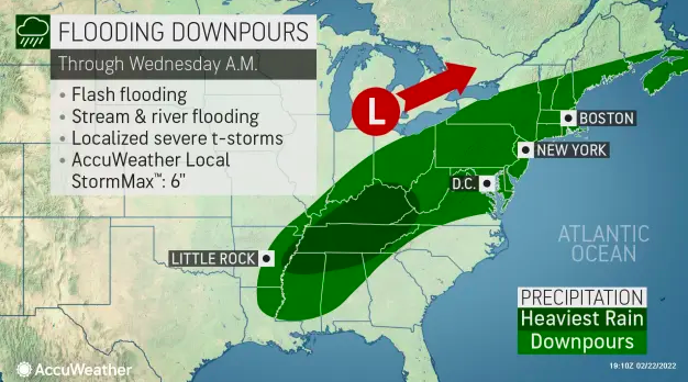
northern watch
TB Fanatic
From my email inbox The Old Farmer's Almanac February 22 2022

alpha
Veteran Member
Electroverse
 Extreme Weather GSM
China’s Gas Prices Soar To Record Highs As Cold Wave Drains Supplies; Summer Chills Strike Tasmania; + Hundreds Of Low Temperature Records Fall Across The U.S.
February 23, 2022 Cap Allon
China’s Gas Prices Soar To Record Highs As Cold Wave Drains Supplies
It’s been a historically frigid February in Eastern Asia, and those fierce wintry conditions are having a knock-on effect on the region’s energy supplies and, in turn, prices.
Looking to the Shanghai Petroleum & Natural Gas Exchange, China’s domestic liquefied natural gas price surged to a record-high on record-low temperatures, a scenario that may spur its importers to snap up cargoes from the spot market and further tighten global supplies, writes Bloomberg.
The national average price for the fuel, carried by trucks to factories or vehicle refueling stations, rallied nearly 80% in the last month to a record 8,114 yuan per ton (about $27.5 per million British thermal units) on Tuesday.
It’s been anomalously cold across China in recent weeks, from the northern mountains…
…to the subtropical south:
Xiamen, Fujian saw snow for the first time in 129 years over the weekend; while rare, record-breaking flakes have also been noted across Southern China in recent days: “It’s a subtropical climate!”, tweeted @SamJermy. “Really odd occurrence.”
Temperatures in Beijing have held well-below the seasonal average for the majority of February, as the yhave across much of China — and looking ahead, the forecast is for more of the same as the week progresses.
Summer Chills Strike Tasmania
My inbox is full of anecdotal reports that Australia is experiencing an unusually nippy summer, particularly its eastern regions. This follows what was a very chilly 2021 across the Aussie continent: the country’s chilliest year of the past decade.
Supporting these emails comes the news that the mercury in the little down of Liawenee, Tasmania dropped to -3.5C (25.7F) on Tuesday morning (Feb 22) — the region’s lowest February temperature since the -3.6C (-25.5F) set back in 1989.
Australia is beginning to cool in line with the rest of the planet, the data clearly shows that; yet government agencies, such as the Bureau of Meteorology, continue to do everything in their power to skew the stats in order to hide any decline: as mentioned above, 2021 was the continent’s coldest year in a decade. And so it stands, if no warm-mongering agenda was in play, and government scientists were led purely by the data and without bias, then there would be no issue with them openly communicating this cooling data with the public, for all us to evaluate and discuss–cooling which actually began globally in 2016:

Hundreds Of Low Temperature Records Fall Across The U.S.
It’s been a glacial start to the week for many Americans as winter 2021-22, rather than abating as the calendar nears March, has instead intensified. Low temperature records are being toppled left, right, and center as Arctic air continues its expansion east and south.
As visualized in coolwx.com‘s unofficial temperature graphic (shown below), for the 24 hours through 08:00 (UTC) Feb 23, hundreds of daily record low temperatures have either been broken or tied, particularly across central and western regions:
 [http://coolwx.com]
The wind chill figures have also proven dangerous, approaching 50 degrees below zero in some locations.
“With wind chills this cold, frostbite could happen in minutes,” warned the National Weather Service. Wind chill advisories extend as far south as northern Texas, where lows are expected to dip below zero Tuesday night in Amarillo.
Accumulating snow has caused problems, too.
The storm walloped the Upper Midwest with heavy snow and thick ice on Monday and Tuesday, creating perilous travel conditions and closing scores of schools and businesses. The NWS issued a blizzard warning for parts of the Dakotas on Tuesday: “Travel is discouraged,” the weather service said. While in nearby Wisconsin, the past 36 hours –to Tues evening– delivered 30 inches of snow to the city of Washburn, located just east of Duluth, Minnesota.
More of the same is in the forecast as that Arctic air mass continues its buildout east and south.
The below GFS run takes us through the weekend:
 GFS 2m Temperature Anomalies (C) Feb 22 – Feb 28 [tropicaltidbits.com].
 GFS Total Snowfall (inches) Feb 23 – March 11 [tropicaltidbits.com].
Elsewhere
While its been a mild winter for Western Europe (with the continent’s chill largely confined to the East), heavy snow has still been hitting its mountain ranges, including the Alps…
On Tuesday, storm “Antonia” delivered feet of fresh powder to the Swiss Alps:
The COLD TIMES are returning, the mid-latitudes are REFREEZING in line with historically low solar activity, cloud-nucleating Cosmic Rays, and a meridional jet stream flow (among many other forcings, including the impending release of the Beaufort Gyre).
Prepare accordingly — learn the facts, relocate if need be and grow your own.
China’s Gas Prices Soar To Record Highs As Cold Wave Drains Supplies; Summer Chills Strike Tasmania; + Hundreds Of Low Temperature Records Fall Across The U.S.
February 23, 2022 Cap Allon
China’s Gas Prices Soar To Record Highs As Cold Wave Drains Supplies
It’s been a historically frigid February in Eastern Asia, and those fierce wintry conditions are having a knock-on effect on the region’s energy supplies and, in turn, prices.
Looking to the Shanghai Petroleum & Natural Gas Exchange, China’s domestic liquefied natural gas price surged to a record-high on record-low temperatures, a scenario that may spur its importers to snap up cargoes from the spot market and further tighten global supplies, writes Bloomberg.
The national average price for the fuel, carried by trucks to factories or vehicle refueling stations, rallied nearly 80% in the last month to a record 8,114 yuan per ton (about $27.5 per million British thermal units) on Tuesday.
It’s been anomalously cold across China in recent weeks, from the northern mountains…
The northern mountainous areas of Guangdong, China. This winter is particularly cold. South China has experienced a cold wave for almost a month. pic.twitter.com/T0BQXjHaaG
— Sharing travel (@lsjngs) February 21, 2022
…to the subtropical south:
Xiamen, Fujian saw snow for the first time in 129 years over the weekend; while rare, record-breaking flakes have also been noted across Southern China in recent days: “It’s a subtropical climate!”, tweeted @SamJermy. “Really odd occurrence.”
Snow in Fujian province, South China today for the first time in over a decade. Some friends have been here 16yrs or more and never seen snow here. Its a subtropical climate! Really odd occurrence. pic.twitter.com/lMJbcboARs
— Sam Victor Jermy (@SamJermy) February 21, 2022
Temperatures in Beijing have held well-below the seasonal average for the majority of February, as the yhave across much of China — and looking ahead, the forecast is for more of the same as the week progresses.
Summer Chills Strike Tasmania
My inbox is full of anecdotal reports that Australia is experiencing an unusually nippy summer, particularly its eastern regions. This follows what was a very chilly 2021 across the Aussie continent: the country’s chilliest year of the past decade.
Supporting these emails comes the news that the mercury in the little down of Liawenee, Tasmania dropped to -3.5C (25.7F) on Tuesday morning (Feb 22) — the region’s lowest February temperature since the -3.6C (-25.5F) set back in 1989.
Summer cold spell in #Tasmania: The little town of Liawenee located at 1055m asl dropped to -3.5C on 22 February, only 0.1C above the February lowest temperature since 1989 when its climatic data starts. pic.twitter.com/VtrSCFlyAU
— Extreme Temperatures Around The World (@extremetemps) February 22, 2022
Australia is beginning to cool in line with the rest of the planet, the data clearly shows that; yet government agencies, such as the Bureau of Meteorology, continue to do everything in their power to skew the stats in order to hide any decline: as mentioned above, 2021 was the continent’s coldest year in a decade. And so it stands, if no warm-mongering agenda was in play, and government scientists were led purely by the data and without bias, then there would be no issue with them openly communicating this cooling data with the public, for all us to evaluate and discuss–cooling which actually began globally in 2016:
Hundreds Of Low Temperature Records Fall Across The U.S.
It’s been a glacial start to the week for many Americans as winter 2021-22, rather than abating as the calendar nears March, has instead intensified. Low temperature records are being toppled left, right, and center as Arctic air continues its expansion east and south.
As visualized in coolwx.com‘s unofficial temperature graphic (shown below), for the 24 hours through 08:00 (UTC) Feb 23, hundreds of daily record low temperatures have either been broken or tied, particularly across central and western regions:
 [http://coolwx.com]
The wind chill figures have also proven dangerous, approaching 50 degrees below zero in some locations.
“With wind chills this cold, frostbite could happen in minutes,” warned the National Weather Service. Wind chill advisories extend as far south as northern Texas, where lows are expected to dip below zero Tuesday night in Amarillo.
Accumulating snow has caused problems, too.
The storm walloped the Upper Midwest with heavy snow and thick ice on Monday and Tuesday, creating perilous travel conditions and closing scores of schools and businesses. The NWS issued a blizzard warning for parts of the Dakotas on Tuesday: “Travel is discouraged,” the weather service said. While in nearby Wisconsin, the past 36 hours –to Tues evening– delivered 30 inches of snow to the city of Washburn, located just east of Duluth, Minnesota.
More of the same is in the forecast as that Arctic air mass continues its buildout east and south.
The below GFS run takes us through the weekend:
 GFS 2m Temperature Anomalies (C) Feb 22 – Feb 28 [tropicaltidbits.com].
 GFS Total Snowfall (inches) Feb 23 – March 11 [tropicaltidbits.com].
Elsewhere
While its been a mild winter for Western Europe (with the continent’s chill largely confined to the East), heavy snow has still been hitting its mountain ranges, including the Alps…
On Tuesday, storm “Antonia” delivered feet of fresh powder to the Swiss Alps:
The COLD TIMES are returning, the mid-latitudes are REFREEZING in line with historically low solar activity, cloud-nucleating Cosmic Rays, and a meridional jet stream flow (among many other forcings, including the impending release of the Beaufort Gyre).
Prepare accordingly — learn the facts, relocate if need be and grow your own.
alpha
Veteran Member
Electroverse
 Extreme Weather GSM
Denver, Seattle, & Others Break Century-Old Low Temp Records; Snow Falls At Low Elevations In California; Michigan’s Upper Peninsula Buried Under Historic February Snow; + Impressive Bering Sea Ice Extent
February 24, 2022 Cap Allon
Denver, Seattle, & Others Break Century-Old Low Temp Records
Arctic air masses continued to smash long-standing low temperature records ACROSS the central and western United States Wednesday, a bitter follow-up to the foot+ of snow received in some locales — lows sank to as much as 30 degrees below zero.
During what is already Denver’s snowiest start to a year on record, the city is also now breaking a string of historic low temperature benchmarks: A record low-max of 8F was logged Tuesday, smashing the previous record of 13F from Feb 22, 1913 (solar minimum of cycle 14, during the Centennial Minimum); and then on Wednesday, a low of -7F was registered, breaking the -4F set in 1899 (the Centennial Minimum), according to the NWS in Boulder:
Likewise, to the northwest, Seattle also toppled a noteworthy record this week.
At 7 AM Wednesday, temperatures at the Seattle-Tacoma Airport dropped to 23F, breaking the previous low for the date of 24F, from 2018. And looking ahead, a further benchmark will be threatened Thursday — the min-high of 36F is under threat.
Wednesday morning also brought new low temperatures to the surrounding areas, including Olympia:
“The calmer wind and clearing sky overnight has allowed morning temperatures to bottom out in the teens and low 20’s — within record territory,” said KOMO News Meteorologist Kristin Clark, speaking to the Seattle area’s chill. “And daytime temperatures will be awfully close to minimum high temperature records for the date.” The snow also isn’t done, continued Clark, who warned of tricky driving conditions.
The Denver and Seattle regions are far from unique when it comes to record-busting cold. Towns and cities across Wyoming have also been double-checking their thermometers this week. In Casper, for example, the mercury topped out at just -2F on Tuesday, annihilating the city’s previous lowest-high for Feb 22 of 16 degrees; and likewise in central Wyoming, maxes in Buffalo struggled to -4F, some 14F below the previous record; while the cities of Rock Springs, Riverton, Worland, Big Piney and Greybull also experienced record cold, reports the NWS.
In fact, hundreds upon hundreds of low temperature benchmarks have fallen this week across the U.S., with an impressive number tumbling over the past 24 hours alone (10:00 UTC Feb 23 – 09:00 UTC Feb 24):

Also worth noting is the thin strip of record warmth which ran up the East Coast–you know, the one the MSM is raving about — but note that this region is about to flip from record warmth to record cold in just a matter of hours (shown below), a development serving as another example of the swings between extremes prevalent during times of low solar activity (such as we’re experiencing now).
 ‘Swings Between Extremes’: GFS 2m Temp Anomalies (C) Feb 23 – Feb 27 [tropicaltidbits.com].
A record 24-hour temperature swing has already occurred in Austin, Texas. The city’s main weather station at Camp Mabry went from 88F at 3:15 PM Tuesday to 32F at 3:15PM Wednesday — a plunge of 56F which bested the previous largest 24-hour swing of 51F which, according to the NWS, happened on three separate occasions: in 1990, in 1994, and in 1955.
And now a second major winter storm –which has already dropped record snow on the West (more on that below)– is consolidating across the CONUS, threatening to bring similar swings between extremes to the Eastern Seaboard. In fact, blizzard conditions and and ice storms threaten major travel troubles from the Midwest to New England Thursday and Friday, with thick icing capable of bringing down trees and power lines.
“Significant ice accumulations greater than 0.25″ are likely from the Red River Valley of Texas through the Ozarks and southeast Missouri. Locally, damaging ice of 0.5″ or more is possible which could lead to scattered power outages, tree damage, and dangerous travel,” the Weather Prediction Center (WPC) tweeted.
The south-central U.S. is the bull’s-eye for ice accumulation, looking at possible totals of up to an inch across areas of northeast Arkansas Thursday, creating hazardous conditions: “Travel could be nearly impossible,” the NWS in Little Rock cautioned. While south-central Pennsylvania and western Maryland could also be looking at ice accumulations of up to a quarter of an inch.
As it stands, some 500 counties in 14 states are currently under a wind chill advisory or warning as polar air extends from Washington State in the West to Washington, D.C. in the East, and from Minnesota in the North to the Texas Panhandle in the South — as discussed in previous posts, this is proving to be a continent-spanning Arctic blast, one that is far from over:
 GFS Total Snowfall (inches) Feb 24 – March 12 [tropicaltidbits.com].
Snow Falls At Low Elevations In California
Southern California residents woke up to a blanket of snow Wednesday morning, after the aforementioned storm brought anomalously cold temperatures into the region.
Snow fell at unusually low elevations –as low as 1,700 feet near Hemet and 2,600 feet in Yucaipa– said NWS meteorologist Philip Gonsalves. Rare dustings of snow continued to fall across the Inland Empire through Wednesday afternoon, including in Upland and Mentone:
“This is a very cold storm,” said Gonsalves. “It’s pretty rare when we report snowfall below 4,000 feet.”
The mountains of Los Angeles County received on average 3 inches of snow, mostly above 3,000 feet, while some higher elevations noted 6 inches. Mountain motorists were urged to avoid travel, and to deploy chains if driving was essential.
The higher California mountains were registering accumulations in the feet — one foot settled on Highway 243 near Idyllwild in Riverside County; San Bernardino logged a foot; while Crestline saw half a foot.
The cold is proving equally challenging and, as it has across much of North America this week, busted records: In Riverside County, Thermal hit 58F, beating the previous record of 60F in 1953; Idyllwild saw a maximum of 29F, besting the 35F from 2007; while Big Bear suffered 23F, usurping 2018’s 27F.
This anomalous cold is forecast to linger, too: “There will be temperatures in the 20s in the Inland Empire, probably some temperatures in the 30s in the low elevations of Orange County,” said Gonsalves. “Climatology speaking, it’s an anomaly, it’s unusual even for this time of year.”
Michigan’s Upper Peninsula Buried Under Historic February Snow
As Metro Detroit prepares for more snow, Michigan’s Upper Peninsula is digging out from record-breaking totals — the NWS office in Marquette reported two consecutive days with multiple historic snowfall numbers, reports detroitnews.com.
A total of 21.6 inches fell on Tuesday, slaughtering the prior Feb 22 record of 7.5 set back in 1974 (solar minimum of cycle 20). Even more impressively, though, “yesterday’s snow was the single largest snowfall amount for any day in February on record,” the NWS tweeted Wednesday, adding that other heavy hauls have been noted across the U.P. this week, with areas prone to NE wind lake-effect seeing their fair share of snow, continued the NWS tweet–referring to Lake Superior:
Looking solely at the NWS station in Marquette (pictured above), Monday notched 0.70 inches of melted snow/precipitation, which broke the record of 0.37 from 1979; the day finished with 9.7 inches of accumulated snow, which felled the date’s previous record of 6.9 from 2009.
However, and as highlighted above, it was Tuesday’s snowfall that took the biscuit. That 21.6 inches not only slaughtered the Feb 22 record of 7.5 set back in 1974, it also bested the locale’s all-time record for the month — the 19.4 inches from Feb 26, 2002.
Marquette has now received 56.3 inches of snow so far in February (with more to come). That’s 26.1 inches above the norm, and also adds to the impressive totals building across the Northern Hemisphere this season which stand at 300+ Gigatons above the 1982-2012 average:
 [FMI]
[FMI]
Impressive Bering Sea Ice Extent
In 2022, the floating ice cover in the Bering Sea reached its greatest February extent since 2013.
The below map shows the extent of sea ice in the Bering Sea as of Feb 16, 2022 — ice covered more than 846,000 square kilometres (327,000 square miles), far exceeding the 1981–2010 mean.
 Bering Sea Ice Extent, Feb 16, 2022 [NSIDC].
The chart below compares each year’s sea ice extent in the Bering Sea with the 1981–2010 mean, as the percent difference from then mean. As you can see, 2022 is riding comfortably above that mean, peaking at more than 20% above it on Feb 16.

During the first two weeks of February an area of low atmospheric pressure developed over the North Pacific Ocean. This drew cold winds in from the north and from the east off Alaska, which chilled surface waters and facilitated the above-average freezing. The north winds then blew that ice south, expanding the ice pack. Unlike most other Arctic seas, the Bering is open to the ocean (except where it is hemmed in by the Aleutian Islands), allowing the ice to expand unimpeded. But across the Arctic this winter season, sea ice extent has been impressive, currently holding at its highest levels since 2008, and before that, 2004.
The COLD TIMES are returning, the mid-latitudes are REFREEZING in line with historically low solar activity, cloud-nucleating Cosmic Rays, and a meridional jet stream flow (among many other forcings, including the impending release of the Beaufort Gyre).
Prepare accordingly — learn the facts, relocate if need be and grow your own.
Denver, Seattle, & Others Break Century-Old Low Temp Records; Snow Falls At Low Elevations In California; Michigan’s Upper Peninsula Buried Under Historic February Snow; + Impressive Bering Sea Ice Extent
February 24, 2022 Cap Allon
Denver, Seattle, & Others Break Century-Old Low Temp Records
Arctic air masses continued to smash long-standing low temperature records ACROSS the central and western United States Wednesday, a bitter follow-up to the foot+ of snow received in some locales — lows sank to as much as 30 degrees below zero.
During what is already Denver’s snowiest start to a year on record, the city is also now breaking a string of historic low temperature benchmarks: A record low-max of 8F was logged Tuesday, smashing the previous record of 13F from Feb 22, 1913 (solar minimum of cycle 14, during the Centennial Minimum); and then on Wednesday, a low of -7F was registered, breaking the -4F set in 1899 (the Centennial Minimum), according to the NWS in Boulder:
Yesterday, the max temp in Denver was 8 degrees which set a new record low max for the day. The previous record was 13 degrees back in 1913.
The low this morning was -7 degrees which set a new record low for the day. The previous record was -4 degrees way back in 1899. #cowx
— NWS Boulder (@NWSBoulder) February 23, 2022
Likewise, to the northwest, Seattle also toppled a noteworthy record this week.
At 7 AM Wednesday, temperatures at the Seattle-Tacoma Airport dropped to 23F, breaking the previous low for the date of 24F, from 2018. And looking ahead, a further benchmark will be threatened Thursday — the min-high of 36F is under threat.
Wednesday morning also brought new low temperatures to the surrounding areas, including Olympia:
Morning lows are in the books. New records Seattle 23°, old record 24° in 2018, Olympia 14°, old record 16° in 2018. Record tied at Quillayute with 24° last set in 2018. Just missing a record Bellingham with 20°, record 19° in 2018. #wawx
— NWS Seattle (@NWSSeattle) February 23, 2022
“The calmer wind and clearing sky overnight has allowed morning temperatures to bottom out in the teens and low 20’s — within record territory,” said KOMO News Meteorologist Kristin Clark, speaking to the Seattle area’s chill. “And daytime temperatures will be awfully close to minimum high temperature records for the date.” The snow also isn’t done, continued Clark, who warned of tricky driving conditions.
The Denver and Seattle regions are far from unique when it comes to record-busting cold. Towns and cities across Wyoming have also been double-checking their thermometers this week. In Casper, for example, the mercury topped out at just -2F on Tuesday, annihilating the city’s previous lowest-high for Feb 22 of 16 degrees; and likewise in central Wyoming, maxes in Buffalo struggled to -4F, some 14F below the previous record; while the cities of Rock Springs, Riverton, Worland, Big Piney and Greybull also experienced record cold, reports the NWS.
In fact, hundreds upon hundreds of low temperature benchmarks have fallen this week across the U.S., with an impressive number tumbling over the past 24 hours alone (10:00 UTC Feb 23 – 09:00 UTC Feb 24):

Also worth noting is the thin strip of record warmth which ran up the East Coast–you know, the one the MSM is raving about — but note that this region is about to flip from record warmth to record cold in just a matter of hours (shown below), a development serving as another example of the swings between extremes prevalent during times of low solar activity (such as we’re experiencing now).
 ‘Swings Between Extremes’: GFS 2m Temp Anomalies (C) Feb 23 – Feb 27 [tropicaltidbits.com].
A record 24-hour temperature swing has already occurred in Austin, Texas. The city’s main weather station at Camp Mabry went from 88F at 3:15 PM Tuesday to 32F at 3:15PM Wednesday — a plunge of 56F which bested the previous largest 24-hour swing of 51F which, according to the NWS, happened on three separate occasions: in 1990, in 1994, and in 1955.
And now a second major winter storm –which has already dropped record snow on the West (more on that below)– is consolidating across the CONUS, threatening to bring similar swings between extremes to the Eastern Seaboard. In fact, blizzard conditions and and ice storms threaten major travel troubles from the Midwest to New England Thursday and Friday, with thick icing capable of bringing down trees and power lines.
“Significant ice accumulations greater than 0.25″ are likely from the Red River Valley of Texas through the Ozarks and southeast Missouri. Locally, damaging ice of 0.5″ or more is possible which could lead to scattered power outages, tree damage, and dangerous travel,” the Weather Prediction Center (WPC) tweeted.
The south-central U.S. is the bull’s-eye for ice accumulation, looking at possible totals of up to an inch across areas of northeast Arkansas Thursday, creating hazardous conditions: “Travel could be nearly impossible,” the NWS in Little Rock cautioned. While south-central Pennsylvania and western Maryland could also be looking at ice accumulations of up to a quarter of an inch.
As it stands, some 500 counties in 14 states are currently under a wind chill advisory or warning as polar air extends from Washington State in the West to Washington, D.C. in the East, and from Minnesota in the North to the Texas Panhandle in the South — as discussed in previous posts, this is proving to be a continent-spanning Arctic blast, one that is far from over:
 GFS Total Snowfall (inches) Feb 24 – March 12 [tropicaltidbits.com].
Snow Falls At Low Elevations In California
Southern California residents woke up to a blanket of snow Wednesday morning, after the aforementioned storm brought anomalously cold temperatures into the region.
Snow fell at unusually low elevations –as low as 1,700 feet near Hemet and 2,600 feet in Yucaipa– said NWS meteorologist Philip Gonsalves. Rare dustings of snow continued to fall across the Inland Empire through Wednesday afternoon, including in Upland and Mentone:
Got a dusting of snow in Mentone this morning! pic.twitter.com/VBna1g32W2
— Joe Nelson (@GumshoeJoe) February 23, 2022
“This is a very cold storm,” said Gonsalves. “It’s pretty rare when we report snowfall below 4,000 feet.”
The mountains of Los Angeles County received on average 3 inches of snow, mostly above 3,000 feet, while some higher elevations noted 6 inches. Mountain motorists were urged to avoid travel, and to deploy chains if driving was essential.
The higher California mountains were registering accumulations in the feet — one foot settled on Highway 243 near Idyllwild in Riverside County; San Bernardino logged a foot; while Crestline saw half a foot.
The cold is proving equally challenging and, as it has across much of North America this week, busted records: In Riverside County, Thermal hit 58F, beating the previous record of 60F in 1953; Idyllwild saw a maximum of 29F, besting the 35F from 2007; while Big Bear suffered 23F, usurping 2018’s 27F.
This anomalous cold is forecast to linger, too: “There will be temperatures in the 20s in the Inland Empire, probably some temperatures in the 30s in the low elevations of Orange County,” said Gonsalves. “Climatology speaking, it’s an anomaly, it’s unusual even for this time of year.”
Michigan’s Upper Peninsula Buried Under Historic February Snow
As Metro Detroit prepares for more snow, Michigan’s Upper Peninsula is digging out from record-breaking totals — the NWS office in Marquette reported two consecutive days with multiple historic snowfall numbers, reports detroitnews.com.
A total of 21.6 inches fell on Tuesday, slaughtering the prior Feb 22 record of 7.5 set back in 1974 (solar minimum of cycle 20). Even more impressively, though, “yesterday’s snow was the single largest snowfall amount for any day in February on record,” the NWS tweeted Wednesday, adding that other heavy hauls have been noted across the U.P. this week, with areas prone to NE wind lake-effect seeing their fair share of snow, continued the NWS tweet–referring to Lake Superior:
Areas prone to NE wind lake-effect have had their fair share of snow the last couple days…our office included. We did set new precip and snow records the last two days. Yesterday's snow was the single largest snowfall amount for any day in February on record. #906wx pic.twitter.com/KsjqWVruO4
— NWS Marquette (@NWSMarquette) February 23, 2022
Looking solely at the NWS station in Marquette (pictured above), Monday notched 0.70 inches of melted snow/precipitation, which broke the record of 0.37 from 1979; the day finished with 9.7 inches of accumulated snow, which felled the date’s previous record of 6.9 from 2009.
However, and as highlighted above, it was Tuesday’s snowfall that took the biscuit. That 21.6 inches not only slaughtered the Feb 22 record of 7.5 set back in 1974, it also bested the locale’s all-time record for the month — the 19.4 inches from Feb 26, 2002.
Marquette has now received 56.3 inches of snow so far in February (with more to come). That’s 26.1 inches above the norm, and also adds to the impressive totals building across the Northern Hemisphere this season which stand at 300+ Gigatons above the 1982-2012 average:
Impressive Bering Sea Ice Extent
In 2022, the floating ice cover in the Bering Sea reached its greatest February extent since 2013.
The below map shows the extent of sea ice in the Bering Sea as of Feb 16, 2022 — ice covered more than 846,000 square kilometres (327,000 square miles), far exceeding the 1981–2010 mean.
 Bering Sea Ice Extent, Feb 16, 2022 [NSIDC].
The chart below compares each year’s sea ice extent in the Bering Sea with the 1981–2010 mean, as the percent difference from then mean. As you can see, 2022 is riding comfortably above that mean, peaking at more than 20% above it on Feb 16.

During the first two weeks of February an area of low atmospheric pressure developed over the North Pacific Ocean. This drew cold winds in from the north and from the east off Alaska, which chilled surface waters and facilitated the above-average freezing. The north winds then blew that ice south, expanding the ice pack. Unlike most other Arctic seas, the Bering is open to the ocean (except where it is hemmed in by the Aleutian Islands), allowing the ice to expand unimpeded. But across the Arctic this winter season, sea ice extent has been impressive, currently holding at its highest levels since 2008, and before that, 2004.
The COLD TIMES are returning, the mid-latitudes are REFREEZING in line with historically low solar activity, cloud-nucleating Cosmic Rays, and a meridional jet stream flow (among many other forcings, including the impending release of the Beaufort Gyre).
Prepare accordingly — learn the facts, relocate if need be and grow your own.
alpha
Veteran Member
Electroverse
 Extreme Weather GSM
Canada Sets A Slew Of Low Temperature Records, 17 In B.C. Alone; More All-Time Snowfall Benchmarks Surpassed In Japan; + Grain Prices Spike, Wheat Nears 2008 Highs
February 25, 2022 Cap Allon
Canada Sets A Slew Of Low Temperature Records, 17 In B.C. Alone
At least 17 low temperature records were broken in British Columbia alone on Wednesday, according to Environment Canada data, as Arctic air parked itself over the province, and indeed over much of the the country, too.
The majority of the fallen records date back decades, with the oldest being the city of Duncan’s -7.2C (18.1F) which, until Wednesday’s -7.7C (18.1F), had held for 105 years–since the year 1917 (the Centennial Minimum).
Other temperature records broken in B.C. (in degrees Celsius) include:
Campbell River: -9.5 bested the -6.6 from 1982; Hope Slide: -16.5 beat the -14.8 set in 1979; Malahat: -7 broke the -6.3 set 2011; Nanaimo: -7.5 vs -5.6 (sate set not indicated); Port Alberni: -9.5 vs -7.2 from way back in 1922; Port Hardy: -4.6 pipped the -4.3 set in 1982; Powell River: -5.5, vs -4.5 from 2017; Qualicum Beach: -6.9 vs -4.6 set in 2018; Sechelt: -4.7 vs -3.6 from 2018; Sparwood: -28.2 vs -26.7 set back in 1956; Squamish: -6.1 vs -5.5 from 2018; Tofino: -4 broke the old record of -3.3 set in 1982; Trail: -17.4 vs -17.1 from 2018; Victoria: -6 pipped the -5.9 set in 1993; West Vancouver: -5.7 usurped the -3.1 from 2018; White Rock: -5.5 bested the -4.4 set in 1957.
This week’s blast of cold air is prevailing south of the border, too, where it continues to deliver record low temperatures and snowy conditions to the United States, disrupting travel, knocking power and toppling trees.
Thursday morning’s readings were the coldest of the polar outbreak so far: International Falls, Minnesota, for example, suffered a staggering -40F, breaking its old daily record of -31F in the process; while Sidney, Nebraska observed -11F, besting its previous benchmark of -8F. Shifting West, some spots in California were testing monthly low temperature records Thursday: Fairfield touched 24F; while Lemoore hit 22F — and across the state, mounting agricultural damage is also being reported.
Thursday morning’s broken cold records come on top of the hundreds upon hundreds that fell Tuesday and Wednesday, including the record low-maxes busted in places like Billings, Mont. (-3F), Oklahoma City (19F), and Wichita Falls (24F). And looking at the coolwx.com animation (embedded below), we can see that the past 24 hours have been just as noteworthy as the 48 hours that preceded it, with those toppled monthly records in California also clearly marked:
 [coolwx.com]
The system is still, as of Friday, affecting more than a hundred million Americans from Texas to Maine.
The Arctic blast –caused by an extreme dip in the jet stream which, in turn, is linked to the historically low solar activity we’re experiencing– is intensifying east of the Rocky Mountains where it is bringing additional icy conditions to the South, Midwest and Northeast — on Friday, as much as a foot of snow is forecast across the NE, including Boston, Albany, and Hartford; while severe icing, of 0.25″ to 1″, is on the cards for many, including in Texas, Arkansas, and Missouri, but elsewhere, too, particularly to the east. At the Weather Service in Little Rock, forecasters didn’t mince words, writing that “power outages and tree damage are likely due to the ice. Travel could be nearly impossible.” As of the early hours of Friday morning, some 35,000 homes are without power in Arkansas alone, according to poweroutage.us.
North of the ice, a zone of snowfall is likely from the Central Plains through the Midwest, and into the Northeast, too.
Concentrating on the Northeast’s forecast snow totals, large portions of New York and New England have been put under a winter storm warning. Rensselaer Mayor, Michael Stammel, has even declared a state of emergency in the city, ahead of the impending snowstorm which could-well deliver more than a foot by the time it’s done. Boston’s flurries began in the early hours of Friday, and by the time the sun is due to rise, there should already be up to half a foot on the ground in some spots. Here, snowfall rates of 1 to 2 inches per hour are expected early Friday, making travel tricky.
As much as 8 inches is likely across the majority of of Southern New England Friday — a flash freeze later in the day also is’t being ruled out, according to latest NWS forecasts, including in Rhode Island.
 GFS 2m Temperature Anomalies (C) Feb 24 – Feb 27 [tropicaltidbits.com].
 GFS Total Snowfall (inches) Feb 25 – March 13 [tropicaltidbits.com].
More All-Time Snowfall Benchmarks Surpassed In Japan
Just briefly –as I’ve discussed Japan a lot in recent weeks– all-time snowfall benchmarks continue to falling for the month of February, particularly across the country’s northern prefectures.
Newest additions to list are Tsunan and Matsunoyama. The snow depth at the former climbed to 4.19m (13.7ft) on Feb 24, totals which surpassed Tsunan’s all-time Feb record of 4.16m (13.6ft) set back in 1989; while the latter, Matsunoyama –which sits at an elevation of just 446m (1,463ft)– touched 5m (16.4ft) as of Thursday, the locale’s highest since 1984 — and with a few more snowy days left to run before the month is done, these records are expected to nudge even higher.
“Absolutely crazy,” writes @ThierryGooseBC on Twitter:
Even crazier totals are being reported elsewhere, with 6.25m (20.5ft) logged at Hiuchi Dam, 6.7m (22ft) at Charmant Hiuchi, and 6.9m (22.6ft) at Tanigawadake Tenjindaira. Putting these figures into context, note the monstrous spikes on the below charts:


Grain Prices Spike, Wheat Nears 2008 Highs
While the stock markets appear calmer, at least as I type this, wheat prices have jumped to their highest level since 2008, threatening to push up food prices in a world already suffering with spiraling inflation. Ukraine is a major wheat exporter, the sixth largest on the planet, hence its nickname ‘the bread basket of Europe’.
Wheat futures in Chicago rose 2.8% to $9.6075 a bushel in early Asian trading, after surging by the maximum allowed by the exchange yesterday, while corn and soybeans also rose — corn climbed 1.2% to $6.9825 a bushel, with soybeans 0.8% higher.
U.S. agribusiness conglomerate Bunge announced Thursday that it had temporarily suspended its Ukraine-based operations at processing facilities in Nikoalev and Dnipro, and the company offices are closed across the country following Russia’s invasion.
Bunge said it employs 1,000 people in Ukraine at two processing facilities and grain elevators as well as a grain export terminal in the Mykolaiv commercial seaport. It also runs a dry corn milling facility in the Vinnytsya region, near Kyiv.
The company said in a statement that its highest priority and primary concern “is for the safety of our employees.” It also attempted to ease supply concerns, adding: “Taking advantage of Bunge’s global network and footprint, the company will work to minimize any impact on our supply chain.”
Prices for wheat, corn, oilseeds and vegoils all rose sharply on Thursday as traders responded to the increased likelihood that invasion and war will cause major disruption to supplies from Black Sea ports and other routes. Ukraine is a major producer and exporter of both wheat and corn, it is also one of the world’s biggest exporters of sunflower seeds and derivatives — any disruptions to exports in the country will have reverberations around the world.
Canada Sets A Slew Of Low Temperature Records, 17 In B.C. Alone; More All-Time Snowfall Benchmarks Surpassed In Japan; + Grain Prices Spike, Wheat Nears 2008 Highs
February 25, 2022 Cap Allon
Canada Sets A Slew Of Low Temperature Records, 17 In B.C. Alone
At least 17 low temperature records were broken in British Columbia alone on Wednesday, according to Environment Canada data, as Arctic air parked itself over the province, and indeed over much of the the country, too.
The majority of the fallen records date back decades, with the oldest being the city of Duncan’s -7.2C (18.1F) which, until Wednesday’s -7.7C (18.1F), had held for 105 years–since the year 1917 (the Centennial Minimum).
Other temperature records broken in B.C. (in degrees Celsius) include:
Campbell River: -9.5 bested the -6.6 from 1982; Hope Slide: -16.5 beat the -14.8 set in 1979; Malahat: -7 broke the -6.3 set 2011; Nanaimo: -7.5 vs -5.6 (sate set not indicated); Port Alberni: -9.5 vs -7.2 from way back in 1922; Port Hardy: -4.6 pipped the -4.3 set in 1982; Powell River: -5.5, vs -4.5 from 2017; Qualicum Beach: -6.9 vs -4.6 set in 2018; Sechelt: -4.7 vs -3.6 from 2018; Sparwood: -28.2 vs -26.7 set back in 1956; Squamish: -6.1 vs -5.5 from 2018; Tofino: -4 broke the old record of -3.3 set in 1982; Trail: -17.4 vs -17.1 from 2018; Victoria: -6 pipped the -5.9 set in 1993; West Vancouver: -5.7 usurped the -3.1 from 2018; White Rock: -5.5 bested the -4.4 set in 1957.
This week’s blast of cold air is prevailing south of the border, too, where it continues to deliver record low temperatures and snowy conditions to the United States, disrupting travel, knocking power and toppling trees.
Thursday morning’s readings were the coldest of the polar outbreak so far: International Falls, Minnesota, for example, suffered a staggering -40F, breaking its old daily record of -31F in the process; while Sidney, Nebraska observed -11F, besting its previous benchmark of -8F. Shifting West, some spots in California were testing monthly low temperature records Thursday: Fairfield touched 24F; while Lemoore hit 22F — and across the state, mounting agricultural damage is also being reported.
Thursday morning’s broken cold records come on top of the hundreds upon hundreds that fell Tuesday and Wednesday, including the record low-maxes busted in places like Billings, Mont. (-3F), Oklahoma City (19F), and Wichita Falls (24F). And looking at the coolwx.com animation (embedded below), we can see that the past 24 hours have been just as noteworthy as the 48 hours that preceded it, with those toppled monthly records in California also clearly marked:
 [coolwx.com]
The system is still, as of Friday, affecting more than a hundred million Americans from Texas to Maine.
The Arctic blast –caused by an extreme dip in the jet stream which, in turn, is linked to the historically low solar activity we’re experiencing– is intensifying east of the Rocky Mountains where it is bringing additional icy conditions to the South, Midwest and Northeast — on Friday, as much as a foot of snow is forecast across the NE, including Boston, Albany, and Hartford; while severe icing, of 0.25″ to 1″, is on the cards for many, including in Texas, Arkansas, and Missouri, but elsewhere, too, particularly to the east. At the Weather Service in Little Rock, forecasters didn’t mince words, writing that “power outages and tree damage are likely due to the ice. Travel could be nearly impossible.” As of the early hours of Friday morning, some 35,000 homes are without power in Arkansas alone, according to poweroutage.us.
North of the ice, a zone of snowfall is likely from the Central Plains through the Midwest, and into the Northeast, too.
Concentrating on the Northeast’s forecast snow totals, large portions of New York and New England have been put under a winter storm warning. Rensselaer Mayor, Michael Stammel, has even declared a state of emergency in the city, ahead of the impending snowstorm which could-well deliver more than a foot by the time it’s done. Boston’s flurries began in the early hours of Friday, and by the time the sun is due to rise, there should already be up to half a foot on the ground in some spots. Here, snowfall rates of 1 to 2 inches per hour are expected early Friday, making travel tricky.
As much as 8 inches is likely across the majority of of Southern New England Friday — a flash freeze later in the day also is’t being ruled out, according to latest NWS forecasts, including in Rhode Island.
 GFS 2m Temperature Anomalies (C) Feb 24 – Feb 27 [tropicaltidbits.com].
 GFS Total Snowfall (inches) Feb 25 – March 13 [tropicaltidbits.com].
More All-Time Snowfall Benchmarks Surpassed In Japan
Just briefly –as I’ve discussed Japan a lot in recent weeks– all-time snowfall benchmarks continue to falling for the month of February, particularly across the country’s northern prefectures.
Newest additions to list are Tsunan and Matsunoyama. The snow depth at the former climbed to 4.19m (13.7ft) on Feb 24, totals which surpassed Tsunan’s all-time Feb record of 4.16m (13.6ft) set back in 1989; while the latter, Matsunoyama –which sits at an elevation of just 446m (1,463ft)– touched 5m (16.4ft) as of Thursday, the locale’s highest since 1984 — and with a few more snowy days left to run before the month is done, these records are expected to nudge even higher.
“Absolutely crazy,” writes @ThierryGooseBC on Twitter:
#Snow depth 419 cm earlier today (Feb. 24) in Tsunan, #Niigata.
All-time record since 1989 (previous record: 416 cm in Feb. 2006).
Snow depth 500 cm in #Matsunoyama (elev. 446 m)!
Highest since 1984. Absolutely crazy!
https://t.co/FOoYrJKFjy#Japan pic.twitter.com/CK0BDFynvh
— Thierry Goose (@ThierryGooseBC) February 24, 2022
Even crazier totals are being reported elsewhere, with 6.25m (20.5ft) logged at Hiuchi Dam, 6.7m (22ft) at Charmant Hiuchi, and 6.9m (22.6ft) at Tanigawadake Tenjindaira. Putting these figures into context, note the monstrous spikes on the below charts:
Grain Prices Spike, Wheat Nears 2008 Highs
While the stock markets appear calmer, at least as I type this, wheat prices have jumped to their highest level since 2008, threatening to push up food prices in a world already suffering with spiraling inflation. Ukraine is a major wheat exporter, the sixth largest on the planet, hence its nickname ‘the bread basket of Europe’.
Wheat futures in Chicago rose 2.8% to $9.6075 a bushel in early Asian trading, after surging by the maximum allowed by the exchange yesterday, while corn and soybeans also rose — corn climbed 1.2% to $6.9825 a bushel, with soybeans 0.8% higher.
U.S. agribusiness conglomerate Bunge announced Thursday that it had temporarily suspended its Ukraine-based operations at processing facilities in Nikoalev and Dnipro, and the company offices are closed across the country following Russia’s invasion.
Bunge said it employs 1,000 people in Ukraine at two processing facilities and grain elevators as well as a grain export terminal in the Mykolaiv commercial seaport. It also runs a dry corn milling facility in the Vinnytsya region, near Kyiv.
The company said in a statement that its highest priority and primary concern “is for the safety of our employees.” It also attempted to ease supply concerns, adding: “Taking advantage of Bunge’s global network and footprint, the company will work to minimize any impact on our supply chain.”
Prices for wheat, corn, oilseeds and vegoils all rose sharply on Thursday as traders responded to the increased likelihood that invasion and war will cause major disruption to supplies from Black Sea ports and other routes. Ukraine is a major producer and exporter of both wheat and corn, it is also one of the world’s biggest exporters of sunflower seeds and derivatives — any disruptions to exports in the country will have reverberations around the world.