Solar Grand Solar Minimum part deux

alpha

Veteran Member
Electroverse

u10serie_cfsRawCorrGefs-2-1-e1646052847255.png
Extreme Weather GSM

Sudden Stratospheric Warming Event Underway; Christchurch Suffers Chilly Lows And Record-Wet Feb; + Midwest and Northeast’s Winter To Extend Into March
February 28, 2022 Cap Allon

Sudden Stratospheric Warming Event Underway
The GFS and its ensembles are forecasting a reduction in westerly zonal winds over the North Pole as we enter March.
The higher latitudes have experienced consistently strong zonal winds to date, and, as a result, below-average temperatures have prevailed at the North Pole, which helped drive Arctic sea ice to its largest extent since 2008, and before that 2004.
A strong Polar Vortex means a strong polar circulation, which usually keeps cold air locked up in the Arctic, and, in turn, results in milder winter conditions for the United States and Europe. Conversely, a weak (wavy) Polar Vortex has a much harder time containing the Arctic’s cold air, and often funnels it south into the lower latitudes.

weather-forecast-north-hemisphere-what-is-strong-weak-polar-vortex-winter-pattern-update

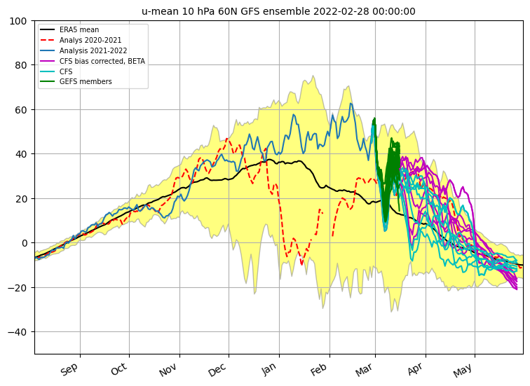
The strength of the polar vortex is most often measured by the power of the winds that it produces. This is typically done by measuring the zonal (west to east) wind speeds around the polar circle (60°N latitude).
Looking at the chart below, we can see that the zonal winds have been strong this winter season (to March). This explains the generally milder conditions enjoyed across the lower latitudes, particularly across Europe. But now, those westerly zonal winds are set to reduce sharply over the coming few days suggesting a rapid weakening of the polar vortex. The runs are in agreement (seethe plunging green line) — a sudden stratospheric warming event could be building:

u10serie_cfsRawCorrGefs-2.png


Here’s a tidier chart (using similar data):

polar-vortex-10mb-wind-speed-zonal-mean-cllimatology-forecast-cfs-gfs


At 10hPa, the stratospheric polar vortex spins high above the weather; but it is still directly connected to the lower levels. It is tied to higher levels, too — and on that note, embedded below is the zonal mean temperature at the North Pole’s higher 50hPa level. There has seen a steady cooling trend observed up there this season, one that picked up the pace in the past few weeks, dropping to record cold levels in mid-February (pink line). Accepting atmospheric levels are connected, this record cold has the potential to permeate down through the layers in the near future.

stratospheric-polar-vortex-50mb-winter-season-2022-zonal-average-temperature-anomaly-nasa-analysis-graph

Likewise, when the stratospheric polar vortex is weakened, eastward winds progress down through the lower atmosphere (into the troposphere) where they then weaken the jet stream. This setup often result in easterly winds down near the surface, too, which, in turn, often results in dramatic reductions in temperature across the lower latitudes.
It should be noted, however, that the polar vortex is just one of many forcings capable of influencing our weather. Case in point: Despite the consistent zonal strength observed high above the North Pole this season, the U.S. has still suffered a number of record-breaking Arctic blasts. But it could stand that a confluence of forcings is needed in order for truly historic conditions to prevail. And with that in mind, let’s look again at that first SSW chart:


Note the red dotted line. This indicates last year’s zonal wind strength. Note the sharp weakening through January — it is this, after the standard 2-or-so weeks lag, and in combination with other forcings, that resulted in America suffering its coldest month of February since the 1980s. It led to the Big Freeze in Texas, during which 5 million homes lost power and 702 people died of the cold, some in their beds while they slept, including children.

702 Texans Died in February's Record-Breaking Freeze, far higher than the State's Official Death Toll of 151 - Electroverse

The impact of this week’s weakening of the zonal winds high above the North Pole (10hPa) is something a wait and see — America, Europe and North Asia don’t yet know their fate. Saying that though, a few recent GFS runs are picking up on signals of a ‘Arctic outbreak’ developing around mid-March, but they are simply too far out to be reliable:

GFS 2m Temperature Anomalies (C) for March 13 [tropicaltidbits.com].

Earth’s climate system is unimaginably complex and wildly unpredictable. For climate scientists to claim they can predict the temperature 50 to 100 years from now is preposterous. To say they know what the sea level will be, or how far glaciers will have retreated is equally absurd. Yet the masses are too consumed with mindless daily tasks to notice; too preoccupied with the ups and downs of the day’s spoon-fed news narrative to see past the lies; too busy simply surviving school runs and rat racing (and the pointless pursuit of a phony career) to have the time to stop and think; and they are too hooked on Instagram dopamine hits to find the willpower to strive for anything more…

Christchurch Suffers Chilly Lows And Record-Wet February

Christchurch just suffered its wettest February since records began in 1944. The city’s total rain this month stands at 148mm (5.8 inches), putting it ahead of the previous record, 1945’s 144.3mm (5.7 inches).
Monday was also bitterly cold — with a reading of 2.6C it was nearly five times lower the monthly minimum average, plus it was also the city’s fifth-coldest February morning on record, according to MetService meteorologist Lewis Ferris.

The last morning of meteorological summer was a cool one for some!

Christchurch airport got down to 2.6°C – its coldest temperature this summer and 5th equal coldest Feb temp since records began there in 1954.

It got down to 1.1°C at Dunedin Airport. 0°C at Waiouru! pic.twitter.com/bBPps32HUU
— MetService (@MetService) February 27, 2022

Another influx of cool air is expected later this week, and additional rain is on the cards Tuesday and Wednesday, too.
More than three times the average rainfall fell in first half of this month in Christchurch, and is is the case in Australia to the west, dire predictions of never-ending drought and wildfires are being upended by record volumes of precipitation.
Activist scientists, such as Tim Flannery, predicted that cities such as Brisbane and Sydney were likely to run out of water very quickly because of man-made global warming. In 2007, Flannery said, “So even the rain that falls isn’t actually going to fill our dams and our river systems…”

Intense rain and record-breaking floods have hit eastern Australia, killing at least eight peopleEight dead as Australian floods break records pic.twitter.com/q24xvknnA6
— BBC News (World) (@BBCWorld) February 28, 2022

More on Australia:
Bureau Of Meteorology's Annual Report Doesn't Link Humans To Climate Change, Also Shows Australia Is Cooling - Electroverse


Midwest and Northeast’s Winter To Extend Into March

As the first day of meteorological spring nears, Americans from the Great Lakes to the New England coast are bracing for another dose of anomalously wintry conditions.
“A parade of clippers is forecast to sweep across the northern tier of the U.S. early week, each time producing a quick burst of snow along the storm track,” said AccuWeather Meteorologist Matt Benz.
The Northeast copped some snow on Sunday, but the first clipper of the week pushes into Minnesota, Wisconsin and Michigan Monday into Monday night. This same system is expected to traverse across the Northeast Tuesday into Tuesday night, too.
As the snow treks across the northern tier of the country, a general coating of 3 inches of is expected.
Two subsequent clippers are then expected to dump snow from North Dakota and Minnesota into the interior Northeast Tuesday into Wednesday and Wednesday into Thursday, each time bringing some quick-hitting flurries for a few hours.
As each clipper departs, freezing temperatures will be left behind.
Much of the Upper Midwest has spent the final week of February in a deep freeze. High temperatures were below zero in Grand Forks, N.D., while Minneapolis was in the teens for most of the week — hundred upon hundreds of low temperature records have tumbled across North America over the past 7 days (including in Canada):


Elsewhere

The first sb -60C of the year has been registered in Antarctica.
On Feb 26, the Japanese Base of Dome Fuji logged a low of to -60.6C (-77.1F) — this is “a quite remarkable value for February,” writes @extremetemps on Twitter, but one that falls short of the Continental record of -65.5C, which is held by Vostok.

Image

The COLD TIMES are returning, the mid-latitudes are REFREEZING in line with historically low solar activity, cloud-nucleating Cosmic Rays, and a meridional jet stream flow (among many other forcings, including the impending release of the Beaufort Gyre).

Prepare accordingly — learn the facts, relocate if need be and grow your own.
 

alpha

Veteran Member
Electroverse
  • Snow Falls On Mt Kinabalu, Malaysia For First Time Since 1993; Rare Lows And Snows Hit Vietnam, Hong Kong, And Taiwan; + Winter Returns To Europe Just In Time For Meteorological Spring

japan-historic-snow-e1646130083827.png
Extreme Weather GSM

Snow Falls On Mt Kinabalu, Malaysia For First Time Since 1993; Rare Lows And Snows Hit Vietnam, Hong Kong, And Taiwan; + Winter Returns To Europe Just In Time For Meteorological Spring
March 1, 2022 Cap Allon

Snow Falls On Mt Kinabalu, Malaysia For First Time Since 1993
Climbers on Mount Kinabalu were given a surprise Monday when rare snow settled over Southeast Asia’s tallest peak. It was like a miracle for the climbers, reports Malaysia Trend.
Hajiri Sulumin, a Via Ferrata trainer, recorded footage of the event that was widely shared online. In the video, Sulumin can be heard exclaiming: “Salji turun! Salji turun! Opurak!” (Snow is falling! Snow is falling! It is white!)
Before Monday, snow had been noted on the mountain on just two previous occasions, in 1993 and 1975 — it is an incredibly rare phenomenon.
“Those who witnessed the snow can consider themselves lucky,” said Sabah Parks Manager, Justinus Guntabid.

Snow fell over Mount Kinabalu this morning for the first time in nearly 30 years.

The incident reportedly happened at around 7.18am and lasted for about three minutes.

Snow was only reported on the mountain twice recently – in 1975 and 1993.

: Mountain Torq/Facebook pic.twitter.com/kSbNNz3uKx
— BFM News (@NewsBFM) February 28, 2022
mount kinabalu having a snow today… chill pic.twitter.com/fi7ZYK142L
— Razali Baba (@RazaliHjBaba) February 28, 2022

Rare Lows And Snows Hit Vietnam, Hong Kong, And Taiwan

As reported last week, the southern Chinese city of Xiamen logged its first snowfall since 1893; but the strong Arctic front didn’t stop at there, frigid air expanded further east, too, into other tropical regions of Asia.
The most notable cooldown of the last 7-10 days was probably that in northern Vietnam, where rare wintry blasts have caused widespread damage to harvests not accustomed to such conditions. Temperatures dropped to -0.4C (31.3F) on Mount Mao Son (1,600m/5,249ft), Lang Son Province; and at lower elevations, in Hanoi, the Vietnamese capital, the mercury fell to an exceptionally low 8.5C (47.3F), with the daily high struggling to just 10.7C (51.3F) — the cold front was Vietnam’s coldest of the past 40 years, reported the Hanoi Times.

Vietnam faces extreme cold. A frosted sign in northern Vietnam as the country faces extreme cold.

Even more noteworthy than the cold, however, was the fact that many places, even densely populated ones, were also hit by surprise snowfall.

Some provinces up north are covered in frost again after a cold snap occurred over the weekend. While the white sceneries excite tourists, local residents and authorities have thoughts of measures to protect cattle and travellers against the cold ❄️ pic.twitter.com/NVsu9K5iAu
— Việt Nam News (@VietnamNewsVNS) February 21, 2022

Unusually cold conditions swept Hong Kong, too. Tai Moh Shan Peak (955m/3,133ft) registered a low of 0.6C (33.1F), while Nong Ping (593m/1,945ft) logged 2.9C (37.2F). And likewise in Taiwan, the nation’s capital of Taipei recently logged an anomalous low of 10.3C (50.5F) and a daily max of only 12.3C (54.1F).

Winter Returns To Europe Just In Time For Meteorological Spring

Winter is making a comeback in Europe, just as the meteorological calendar flips to spring.
The last day of February in Rokytská Slať, Czechia, for example, brought lows of -21C (-8.8F) to the valleys:


Frosts, and also snowfall, has surprised many European residents in recent days, residents who have been accustomed to mild conditions this winter with the continent’s cold having been largely confined to the east (where it has proven record-shattering). And looking ahead, the month of March looks set to continue where February left off — Winter is making an icy comeback –one perhaps aided by the SSW event building high above the Arctic– and it will deliver widespread frosts to the lowlands, with -10C (14F) observed in the basins, and -20C (4F) in the valleys — a cruel trick on Europe’s early flowering buds.
GFS runs (shown below) are beginning to pick up on this cooling signal, and things are forecast to turn especially frosty starting March 6. A Grand Solar Minimum foretells of an extension of winter–a late arrival of spring; and this was the case in Europe last year, too. I recall England, for example, suffering its coldest April since 1922 and is chilliest start to May since record-keeping began back in 1659, SW England was suffering freezing lows well into May.

England is on for its Coldest May since Record-Keeping Began back in 1659 (during the Maunder Minimum) - Electroverse

I’m not ruling out a similar setup occurring this year, too — the latest GFS runs are hinting at it, at least:

GFS 2m Temperature Anomalies (C) March 6 – March 11 [tropicaltidbits.com].
GFS Total Snowfall (inches) March 1 – March 17 [tropicaltidbits.com].

Likewise in North America, the models appear to be doubling-down on that polar outbreak scheduled for mid-March that I discussed yesterday (runs are still in the unreliable time frame, however — be sure to stay tuned for updates):

GFS 2m Temperature Anomalies (C) March 8 – March 13 [tropicaltidbits.com].
GFS Total Snowfall (inches) March 1 – March 17 [tropicaltidbits.com].

Also, descending masses of polar cold are also threatening northern Asia, including vast swathes of Siberia:

GFS 2m Temperature Anomalies (C) March 7 – March 17 [tropicaltidbits.com].
GFS Total Snowfall (inches) March 1 – March 17 [tropicaltidbits.com].

Elsewhere

And finally, the below image comes from Japan, where record-breaking snowfall –of 6.9m (23ft) and more– continues to batter the country, particularly its northern prefectures such as Hokkaido:


The COLD TIMES are returning, the mid-latitudes are REFREEZING in line with historically low solar activity, cloud-nucleating Cosmic Rays, and a meridional jet stream flow (among many other forcings, including the impending release of the Beaufort Gyre).

Prepare accordingly — learn the facts, relocate if need be and grow your own.
 

alpha

Veteran Member
Sorry for the pause in updating the Electroverse stuff, too busy fleeing my Southern refuge (Myrtle Beach) to get to my farm and BOL ASAP! Towing a 34 foot trailer tends to slow down progress while watching gasoline prices rise exponentially. I should be home tomorrow and able to get back to work here!!!
 

alpha

Veteran Member
Electroverse

Snow-Turkey-e1646388039560.jpg
Extreme Weather Grow Your Own

Anomalously Frigid Febs For Australia, Japan, South Korea and Hong Kong; Sardinia Suffers Lowest March Temperature Ever; Heavy Snow Blankets Turkey, Delaying Spring; + Winter Will Have “Final, Punishing Act” For Lower-48
March 4, 2022 Cap Allon

Anomalously Frigid Febs For…
The following averages rely on unreliable ground based temperature stations, which are susceptible to the Urban Heat Island effect–among other issues, including outright tampering; but despite this, many countries still managed to suffer colder than average Februaries.
…Australia
Even the Bureau of Meteorology weren’t able to completely fudge away what was an unusually chilly February 2022 down under.
The Aussie continent finished the month with an average temperature anomaly of -0.6C below the 1991-2020 norm. It was noticeably warm in Western Australia, but that warmth was far outstripped by the those “greens” in the central, southern and eastern parts:

Temperatures and rainfall anomalies maps by BOM

Also, despite pockets of extreme flooding, it was also a dry month; overall, rainfall was 24% below normal:

Image

…Japan

February 2022 in Japan was both cold and historically snowy.
The temperature anomaly for the country came out at -0.67C below the 1991-2020 norm.
These persistently frigid conditions are expected to have delayed Tokyo’s cherry blossoming until late March.

Anomalies maps by JMA. Kudos to climatic expert Tomoki Suzuki for the cherry blossoming data.

…South Korea

Last month was extremely cold in South Korea. It was very dry, too.
Feb 2022 had an average temperature of -0.1C, which is -1.3C below the 1991-2020 baseline — this freeze drops the overall Winter anomaly (Dec-Feb) to -0.2C below the historical average.
Below maps courtesy of KMA.
Image
…and Hong Kong
And lastly, February 2022 in Hong Kong was exceptionally chilly, and also wet.
The Administrative Region’s average temperature came out at 15.2C which is a whopping -1.9C below the 1991-2020.
Average rainfall was 168.5mm, a reading more than 4 times the norm.
Below stats courtesy of HK Observatory.

Image

Sardinia Suffers Lowest March Temperature Ever

Much of Europe is experiencing a return to wintry conditions, even Mediterranean islands, such as Corsica and Sardinia, are suffering all-time record breaking lows for the month of March.
The mercury in Villanova Strisaili (813m/2,667ft) recently plunged to -11.2C (11.8F) — the lowest temperature ever recorded in Sardinia in March.

Guide to Sardinia and Corsica

And looking ahead, Europe’s spring freeze will persist for at least the next few weeks, as Arctic air rides unusually-far south on the back of a low solar activity induced weak and wavy meridional jet stream flow:

GFS 2m Temp Anomalies (C) March 11 [tropicaltidbits.com].

Heavy Snow Blankets Turkey, Delaying Onset Of Spring

And likewise in southeastern Europe –and also into the Middle East and southwestern Asia– bone chilling lows and heavy snows continue to disrupt daily life, most notably ACROSS Turkey where full-blown wintry conditions are forecast to persist through mid-March–which is highly unusual.
The Turkish State Meteorological Services (TSMS) warned on Thursday that 63 provinces were exposed to heavy snowfall, rain and strong winds. The snow has seen the closure of a host of schools, and many roads, also including two connecting Antalya and the capital Ankara, reports dailysabah.com, where snowplows and 4,230 personnel are working around the clock in an attempt to keep the streets clear: “You can go home or to work safely,” tweeted Ankara’s mayor, Mansur Yavaş.
According to the TSMS, snowfall will prevail in most regions of the country into the weekend. Turkey’s most populated city, Istanbul, which was exposed to snowfall chaos in January, has also seen sporadic snowfall this week, as well as unusually low temperatures. The TSMS also warned of avalanches in eastern Anatolia and elevated locations of the eastern Black Sea region.

This winter has been exceptionally hard for Turkey’s farmers — and despite the elements, the animals still need their feed:

Image [@murceltahtaci]

Winter Will Have “Final, Punishing Act” For Lower-48

A sharp blast of cold is expected to invade the CONUS mid-March, chasing what was a fiercely cold and snowy February…
The NWS says so far this winter The Red River Valley, which stretches across Minnesota and North Dakota, has seen a record-breaking 11 blizzards. That compares to old benchmark of 10, tied by the 2013-14 and 1996-97 seasons. It’s also well above the average 2.6 blizzards during a typical winter. February was also a cold month for the region. The average temperature finished almost 9 degrees (F) below average at the NWS office in Grand Forks. Weather watchers are now keeping a close eye on the next polar front which is forecast to bring further snows and extreme lows to the region this weekend, according to the CPC.
This next system, believe or not, is the more modest of two which are set to plunge into the CONUS over the next 14 days; however, although relatively weak it will still pack a punch and threatens, for example, a 140-year-old cold record in Southern California.
Re that SoCal freeze, and as reported by msn.com: The cold snap has experts pondering how low temperatures would have plunged had a similar atmospheric setup been in place 140 years ago when there were far fewer urban heat island effects. Curious nod to the UHI there…? AccuWeather Meteorologist Ryan Adamson called the upcoming chill “startling for some” in the wake of above-average temperatures (see swings between extremes). The article continues: On Saturday night, AccuWeather is projecting a low within striking distance of the bottom mark for the date of 39-degree set in 1882. Temperatures around the 40-degree mark on Sunday night would tie that date’s record low which has stood since 1893.
But as mentioned above, the second front will prove ‘the biggie’–in both ferocity and scale, and whether you live in Seattle, Washington; Wichita, Kansas; or Washington, D.C., record-breaking cold is on the cards come mid-March:

GFS 2m Temp Anomalies (C) March 8 – March 13 [tropicaltidbits.com].

As are anomalous flurries of late-season snow:

GFS Total Snowfall (inches) March 4 – March 20 [tropicaltidbits.com].

The COLD TIMES are returning, the mid-latitudes are REFREEZING in line with historically low solar activity, cloud-nucleating Cosmic Rays, and a meridional jet stream flow (among many other forcings, including the impending release of the Beaufort Gyre).

Prepare accordingly — learn the facts, relocate if need be and grow your own.
 

TxGal

Day by day
Here's a new podcast from Ice Age Farmer, things are looking rough:

"Brace for Rationing" - Food Crisis Escalates - EU farmers furious - YouTube

View: https://youtu.be/_F6ilTV3rpY
Run time is 12:42

Synopsis provided:

The food crisis is escalating: more countries are halting exports, but even as the EU converges a food crisis meeting, they refuse to relax restrictions on farmers. Similarly, the US is not waiving biofuel mandates even as grain prices explode. Christian explains that this crisis is needed to advance the agenda, and reiterates the priorities for your victory garden to insulate your family and community from this worldwide food crisis. Start growing today.
 

alpha

Veteran Member
Ice Age Farmer is making a serious case for growing your own food!

IAF.jpg
Ice Age Farmer

Mainstream media now telling you: get ready for FOOD RATIONING.

And they are blaming Putin for the world food crisis. But you and I know better. Today's video report forthcoming.
___

Rabobank says we must contend with intense La Niña weather patterns and drought in Brazil and Argentina. “Grain shortfalls are likely to be so pronounced as to require demand destruction, or rationing,” it said.

“Unlike the West, China is prepared. It has been stocking up for months and holds 84 per cent of the world’s copper, 70 per cent of its corn and 51 per cent of its wheat. “China has bought enormous quantities of US soy in recent weeks,” said Rabobank. One might ask if Xi Jinping knew something in advance.”

join: @iceagefarmer

Putin’s energy shock is becoming a world food crisis. Brace for rationing.

The Sydney Morning Herald

Putin’s energy shock is becoming a world food crisis. Brace for rationing.

Shortage of grain and other agricultural commodities means a billion of the world’s poorest people will go even hungrier thanks to Putin’s deranged misadventure, and some will starve. Our next moral mission is to help them.


68.6K views

IAF.jpg
Ice Age Farmer

"Brace for Rationing" - Food Crisis Escalates - EU farmers furious

The food crisis is escalating:
more countries are halting exports, but even as the EU converges a food crisis meeting, they refuse to relax restrictions on farmers. Similarly, the US is not waiving biofuel mandates even as grain prices explode. Christian explains that this crisis is needed to advance the agenda, and reiterates the priorities for your victory garden to insulate your family and community from this worldwide food crisis. Start growing today.

join: @iceagefarmer

“Brace for Rationing” – Food Crisis Escalates – EU farmers furious

Youtube:
View: https://youtu.be/_F6ilTV3rpY

Bitchute: "Brace for Rationing" - Food Crisis Escalates - EU farmers furious

#iafvideo #ukraine #russia #wheat #eu #usa

YouTube

"Brace for Rationing" - Food Crisis Escalates - EU farmers furious

The food crisis is escalating: more countries are halting exports, but even as the EU converges a food crisis meeting, they refuse to relax restrictions on farmers. Similarly, the US is not waiving biofuel mandates even as grain prices explode. Christian…


67.9K viewsedited

IAF.jpg
Ice Age Farmer

China ag minister says winter wheat condition could be worst in history

The condition of China's winter wheat crop could be the "worst in history", the agriculture minister said on Saturday, raising concerns about grain supplies in the world's biggest wheat consumer.

Speaking to reporters on the sidelines of the country's annual parliament meeting, Minister of Agriculture and Rural Affairs Tang Renjian said that rare heavy rainfall last year delayed the planting of about one-third of the normal wheat acreage.

#wheat #China #GrandSolarMinimum

China agriculture minister says winter wheat condition could be worst in history

Reuters

China ag minister says winter wheat condition could be worst in history

The condition of China's winter wheat crop could be the "worst in history", the agriculture minister said on Saturday, raising concerns about grain supplies in the world's biggest wheat consumer.


30.1K views

March 5

IAF.jpg
Ice Age Farmer

With mainstream media pushing idea of rationing food, the technocrats seem to be pivoting to digital ration cards. Too much resistance to mandates/passports? Just stage a war and cut the food.

As Kissinger said: “Control food and you control people.”

MSM:

Putin’s energy shock is becoming a world food crisis. Brace for rationing.

My report: “Brace for Rationing” – Food Crisis Escalates – EU farmers furious

Business Insider

Putin’s energy shock is becoming a world food crisis. Brace for rationing.

Shortage of grain and other agricultural commodities means a billion of the world’s poorest people will go even hungrier thanks to Putin’s derange...


51.9K viewsedited

IAF.jpg
Ice Age Farmer

Syria is the latest to ban exports of foodstuffs as the food crisis escalates.

#FoodShortages

Syria bans exports of some foodstuffs to prevent food shortages - ENGLISH PICHINCHA

ENGLISH PICHINCHA

Syria bans exports of some foodstuffs to prevent food shortages - ENGLISH PICHINCHA

The Syrian government today banned the export of several foodstuffs as part of a package of measures aimed at mitigating the impact resulting from the conflict in Ukraine on the country’s economy and the availability [...]


3.8K views


March 7

IAF.jpg
Ice Age Farmer

Ukraine is about 3 weeks out from planting this season’s crop — and seeds are not showing up. Forget the early analyses about “25% hit to yield” - this is devolving to a completely catastrophic blow to food production. In the area that supplied 40% of worlds grain.
Ice Age Farmer
#ukraine #corn #FoodShortage

4.6K views
 

alpha

Veteran Member
Electroverse


snow-ukraine-2-scaled-e1646736703810.jpg
Crop Loss Extreme Weather GSM

Jan-Like Cold Targets U.S.; New Study Questions Explanation For Feb 2021’s Record Freeze; + Ukraine Halts All Exports, Clears Farm Workers From Military Service
March 8, 2022 Cap Allon

January-Like Cold Targets U.S.
The calendar may read March, but Jan-like lows are set to dominate a large portion of the U.S. this week. AccuWeather forecasters say temperatures will plunge to levels more typical of mid-winter than meteorological spring.
Central and Western states copped a taste of what’s to come as accumulating snow hit areas from the Plains to the Great Lakes region Sunday and Monday. Next up is a full-blown invasion of polar cold, one eyeing the majority of the United States. Arctic air is forecast to settle into the northern Plains midweek sinking temperatures some 20F below the seasonal average by Thursday afternoon. A high of 19F is forecast Thursday in Minneapolis, where the normal high is 37F; while in Fargo, North Dakota, the daily max will struggle to 14F, where the norm is 33F. Temps have averaged well-below average in these cities so far in March — after the first six days of the month, Fargo was running 3.7F below normal.
This Arctic outbreak will be a shock to the system for most, particularly those regions coming off the back of anomalous warmth — Sioux Falls and Rapid City, South Dakota, for example, touched 20F above normal at the start of March, but temperatures are forecast to swing 20 degrees below normal by Thursday (see GSM and the Swing Between Extremes):

GFS 2m Temperature Anomalies (C) March 7 – March 13 [tropicaltidbits.com].

A storm is expected to ride along the southern extent of the cold front, spreading substantial snowfall from the Rockies into the Midwest. The highest totals are likely to occur across elevated regions of the Rockies, as you would expect; however, inches will extend across South Dakota and Nebraska into Iowa, southern Minnesota, Wisconsin, and elsewhere into Thursday, making for potential treacherous travel conditions:

GFS Total Snowfall (inches) March 8 – March 24 [tropicaltidbits.com].

Even colder conditions are forecast Friday and into the weekend, aided by the settled snow.
“Clearing skies will likely accompany the cold air moving in from Canada, further dropping temperatures on Thursday night. By Friday morning, some locales across the North Central states could be flirting with record low temperatures,” said AccuWeather Meteorologist Brandon Buckingham.
Temperatures Friday morning will be in the single digits for many regions; others, including Fargo, ND, will likely dip below zero; while across the northern High Plains, as well as just east of the front range, readings of as lows as -10F will hit — temperatures more typical of January.
“By early Saturday morning, freezing temperatures can reach northwest Texas, including Dallas,” said AccuWeather Lead Long-Range Meteorologist Paul Pastelok. Some cities like Amarillo, Texas, and Oklahoma City could dip down into the teens late in the week — wintry conditions the meteorologist says is caused by 1) the jet stream diving southward, and 2) a second storm system bringing snow to the eastern U.S. which, in turn, will assist in transporting the cold farther south and east.
It’s already been anomalously chilly in Texas this week. So cold in fact that several IndyCar drivers had to cancel test runs at Texas Motor Speedway on Monday, for safety reasons. Temperatures were in the 30s Monday morning, making the track too dangerous for laps. There is an ambient temperature formula that decides whether IndyCar tracks are safe to run. The combined reading of the air and track surface must total 100F, but it was 40F at noon Monday and is expected to be even colder Tuesday.
“I was a little shocked to see flurries this morning in Texas,” said driver Scott Dixon.

New Study Questions Explanation For Feb 2021’s Record Freeze

A new study challenges a commonly accepted explanation that a sudden stratospheric warming event (SSW) caused the exceptionally cold weather over the U.S. early last year–a view which was widely reported in the media and discussed among scientists at the time.
Instead, new research finds that the sudden warming high above the Arctic in early 2021 –and the accompanying disruption of the polar vortex– did not significantly impact the brutal cold snap that gripped Texas that followed. For the study, published last week in the journal Nature Communications, a team of scientists led by the National Center for Atmospheric Research (NCAR) used an Earth system model to analyze the SSW event that occurred on Feb 8, 2021 and its potential impacts. Using a new method to assess causality, they found that while the subsequent weather did indeed match the expected pattern, the sudden stratospheric warming itself was not the likely cause.
“The mechanisms for how these layers of the atmosphere interact are probably more nuanced than we’re giving them credit for, and that’s important for making better forecast models,” said NCAR scientist Nicholas Davis, who led the study.
During the Northern Hemisphere winter, when the North Pole tilts away from the Sun and remains shrouded in darkness, a mass of cold air forms in the stratosphere above the pole. This frigid air is locked into place by a jet stream called the stratospheric polar vortex. Occasionally, this vortex is disrupted by planetary-scale waves which propagate upward from the troposphere. When these planetary-scale waves break, they warm the vortex, which can weaken it and cause it to be displaced or split in two — an event known as a sudden stratospheric warming. And after a two-or-so week delay, this split can lead to Arctic air spilling out of the pole and into the likes of Siberia, Europe, and the U.S.. The polar vortex can also be impacted by events from above, by forcings like solar activity and cosmic radiation (e.g. cosmic rays), but such mechanisms are even less understood, and so are often completely excluded from the models.

An infographic of arctic air spilling into north Ameririca Arctic outbreak, Feb 9, 2021.

For their new study, the researchers dug into the connections between the stratosphere and troposphere. To cut a long and rather tedious story as short as possible, after numerous model runs, with each giving different results, the scientists found that events in the stratosphere rarely had any impact on tropospheric weather (i.e. Arctic outbreaks). Instead, the initial state of the troposphere was the primary driver.
“I think everyone imagined that a pinball is shot up from the troposphere, hits the polar vortex, and breaks it apart,” said Davis. “And then another pinball shoots back down and changes the weather. But this study shows that it’s not so simple. I think it possible that the events in the troposphere and the stratosphere are feeding back on one another and reinforcing what’s happening.”
Scientists have long posited that a disturbed polar vortex can reflect planetary waves back down into the troposphere where they can intensify weather systems and create cold air outbreaks in the United States, but whether this mechanism is actually at work is now unclear. And specifically to the record-breaking cold that swept Texas and the central U.S. in mid-Feb 2021, this outbreak occurred six weeks after the SSW, meaning it was beyond the timeframe of predictability associated with that event. However, at just six weeks after, the vortex would not of yet fully recovered, it would of remained somewhat stretched, looped down over North America –a configuration often associated with cold air outbreaks in the U.S.– and so could of still played a role, only it wasn’t the dominant player that scientists/the MSM had previously concluded/reported. In conclusions, this new research suggests that the vortex stretching and wave reflection did not drive the cold air breakout of mid-Feb 2021, something else did (low solar activity weakening the jet stream?).
It stands that the same atmospheric elements that cause a sudden stratospheric warming event –and associated distortion in the polar vortex– may also be causing the tropospheric weather patterns, and that the SSW itself may be helping to sustain them over long periods. The only thing I can say with any certainty, however, is that these elements aren’t understood, and as is all too often the case when digging into a widely held scientific assumption, it turns out that its foundations are incredibly weak. Science does a very poor job at explaining our surroundings, but that’s not to say its endeavor is futile, far from it, it’s to say that we should treat its pronouncements less like the gospel and more with the original intent it had in mind: to deliver our best guess.

Ukraine Halts All Exports, Clears Farm Workers From Military Service

The Ukrainian government has banned the export of essential products and severely limited the export of grains, official documents have shown. This move comes as all Ukrainian exports, which mainly go through the country’s Black Sea ports, stopped due to the Russian invasion.
The measures restrict exports of essential goods such as buckwheat, rye, sugar, millet, oats, salt, live cattle, the meat of cattle, and other subproducts from cattle, as the country faces increased demand along with the possibility of lower supply amid the war. Along with that, the government has decided to put limits on grain exports, including wheat, corn, sunflower oil, poultry and eggs. As a result, this disruption has caused commodity markets to fire into record-breaking territory this week.
There are also reports that some cities within the Ukraine are already facing a humanitarian disaster as basic supplies are no longer available amid either occupation by the Russian army or active sieges and heavy fighting close by.
The Ukraine is known as the breadbasket of Europe. And with the conflict threatening to impact the country’s spring planting, which is now just around the corner, the government has imposed measures aimed at helping to manage planting and harvesting — it has been announced that key employees engaged in the agriculture sector will be excused from military operations: “In order to timely conduct a complex of spring-summer fieldwork, agricultural enterprises and food producers must submit lists of critical workers to the Ministry of Agrarian Policy who will be granted a deferment from military service during mobilization and wartime,” the official notice showed.
That’s one hurdle crossed, now Eastern Europe just needs the weather to hold:

GFS 2m Temperature Anomalies (C) March 7 – March 11 [tropicaltidbits.com].
GFS Total Snowfall (inches) March 8 – March 24 [tropicaltidbits.com].

The COLD TIMES are returning, the mid-latitudes are REFREEZING in line with historically low solar activity, cloud-nucleating Cosmic Rays, and a meridional jet stream flow (among many other forcings, including the impending release of the Beaufort Gyre).

Prepare accordingly — learn the facts, relocate if need be and grow your own.
 

alpha

Veteran Member
Electroverse

snowy-gas-station-e1646820110643.png
Crop Loss Extreme Weather GSM Volcanic & Seismic Activity

U.S. Suffered A Cold February, -1.89F Below Average; + Manam Erupts To 50,000 Feet
March 9, 2022 Cap Allon

U.S. Suffered A Cold February, -1.89F Below Average
Even according to the data-fudging folks at NOAA –who have admitted they “guess” Earth’s temperature due to poor ground station coverage– it was an unusually cold month of February across the United States.
The 48 contiguous States finished with an average temperature of 33.8F which is -1.89F below the multidecadal baseline:

February 2022 Mean Temperature Departures from Average map

This comes off the back of a chilly Jan, too — the United State’s chillest month of January since 2014, again according to NOAA data. February’s freeze also chimes with what the satellites saw, with the UAH registering a below avg month for the U.S., which also continues the overall global cooling trend witnessed since 2016’s peak:


Looking ahead, March won’t bring any relief — quite the opposite. This week, and through the weekend, the majority of the U.S. can expect a fierce blast of Arctic air–air rivaling some of the coldest ever recorded in mid-March:

GFS 2m Temperature Anomalies (C) March 8 – March 13 [tropicaltidbits.com].
gfs_asnow_us_fh0-384-7.gif
GFS Total Snowfall (inches) March 9 – March 25 [tropicaltidbits.com].

Historic cold has already struck many parts of the country this season where it has caused a myriad of problems, including to the valley tree crops of California — a cold spell at the end of February plunged much of the Sacramento Valley into record-low territory.
“Every flower can produce an almond,” explained grower Tim Taylor. “When that freeze hits and these are developing … once they start to develop like this”–Taylor sliced into a blossom to check the developing nut–“see that black inside? That means it’s frozen. It froze, and it’s dead.”
Taylor estimates that 60% of his almond orchard was damaged by the freeze, potentially decimating his yield. It was particularly dispiriting after expectations were for a bountiful year. “We had a wonderful February,” Taylor said. “It was looking pretty darn good until all of a sudden it decided to freeze for four days.”
Similar scenes are playing out up and down the Central Valley, reports agalert.com, where temperatures reached the low to mid-20s most of Presidents Day week. Many growers went to extreme lengths in order to warm up the trees, including hiring helicopters. Mike Vereschagin, an almond grower in Orland, said it “sounded like a military zone out there with all the helicopters flying, trying to push down the warmer air from above into the orchards.” However, for that to work, there has to be an inversion layer which, according to Mel Machado, director of member relations at Blue Diamond Growers, was light to nonexistent this time. “One guy told me he had a helicopter at 200 feet before it found anything warm,” said Machado. “That’s useless. You need to have air 30, 40 feet off the canopies to make that work.”

Manam Erupts To 50,000 Feet

On Tuesday, March 8, Papa New Guinea’s highly active Manam Volcano produced another stratospheric eruption, continuing its uptick which began in 2010.
A thick volcanic ash plume rising to at least 50,000 feet (15.2 km) was registered by the Volcanic Ash Advisory Center (VAAC) Darwin using HIMAWARI-8 satellite imagery:

BREAKING: A large-scale volcanic eruption occurred in the Manam Volcano in Papua New Guinea at 5:50 p.m. (UTC+8), according to JMA. #Manam

Himawari-8 captures the volcano ash cloud at the time of its eruption. pic.twitter.com/yxxfJzZhOe
— Matthew Cuyugan (@MatthewCuyugan) March 8, 2022

Such as high-level eruption is noteworthy because particulates ejected to altitudes above 32,800 ft (10 km) –i.e. into the stratosphere– often linger, where they have a direct cooling effect on the planet.
Volcanic eruptions are one of the key forcings driving Earth into its next bout of global cooling. Their worldwide uptick is tied to low solar activity, coronal holes, a waning magnetosphere, and the influx of Cosmic Rays penetrating silica-rich magma.
Hunga Tonga’s eruption of Jan 15 fired particulates through the stratosphere and into the mesosphere; at 36 miles up, it was the highest volcanic eruption ever recorded. Those particulates are now ‘trapped’ in the upper atmosphere where they are expected to cool the planet by approx. 0.3C.

New: the Hunga Tonga eruption spewed ash a record 36 miles into the atmosphere — blowing through troposphere/stratosphere into the mesosphere (where meteors burn up).

That’s 3X as high as the worst thunderstorms and 14 miles taller than Punatubo’s plume. https://t.co/ZoHSpjZ0HP
— Matthew Cappucci (@MatthewCappucci) March 5, 2022

Manam Background

Stratovolcano: 1807 m / 5,928 ft
Papua New Guinea: -4.08°S / 145.04°E
Current status: ERUPTING (4 out of 5)
Manam volcano, located 13 km off the northern coast of New Guinea near Bogia town, is one of Papua New Guinea’s most active volcanoes. It has one of the longest records of historic eruptions in the SE Pacific region. The larger eruptions of Manam produce pyroclastic flows and sometimes lava flows. Both have repeatedly reached the coast and affected populated areas.
The volcano’s current ongoing eruptive phase technically began back on June 29, 2014 and it has already registered a “4” on the Volcanic Explosivity Index (VEI). Manam’s eruptive history is peppered with VEI 2s and 3s, but it also has two previous confirmed VEI 4s, from 2004 and 1919 — see volcano.si.edu for more.
Eruption list: ongoing since Aug 2010 (31 July 2015: large vulcanian explosion), 2000-2004 (small subplinian eruptions), 1974-1999, 1965-66, 1963-64, 1963, 1962, 1961, 1959-60, 1959, 1956-58, 1954, 1953, 1946-47, 1936-39, 1932-34, 1926-28, 1925, 1924?, 1923, 1922, 1920-21, 1919, 1917, 1909-14?, 1907?, 1904, 1904, 1901-02?, 1899, 1887-95, 1885, 1884?, 1887, 1830, 1700, 1643, 1616 — for more see VolcanoDiscovery.com.


The COLD TIMES are returning, the mid-latitudes are REFREEZING in line with historically low solar activity, cloud-nucleating Cosmic Rays, and a meridional jet stream flow (among many other forcings, including the impending release of the Beaufort Gyre).

Prepare accordingly — learn the facts, relocate if need be and grow your own.
 

alpha

Veteran Member
Electroverse
snow-russian-tanks.jpg
Articles Extreme Weather GSM

March Snowstorm Sweeps Greece; “Polar Vortex” To Bring Record Low Temps And “Monster” Nor’Easter To U.S.; + Russian Soldiers Expected To Die In -20C (-4F) Cold As Their Tanks Turn Into “Iron-Clad Freezers”
March 10, 2022 Cap Allon

March Snowstorm Sweeps Greece
Unseasonable lows are sweeping much of Greece this week, as the arrival of storm Filippos drops rare and heavy snow over much of southeastern Europe–even over the region’s lower elevations–even over Athens (20m/65ft):
NO MORE snow ‍♀️#Athens morning snow just started#Greece #Φιλιππος pic.twitter.com/zLEQqtmGOL
— Christina Themelis (@tinathemelis) March 10, 2022

According to the National Observatory of Athens, the freeze is caused by an influx of frigid air from N Europe riding which is riding unusually far south on the back of a weak and wavy jet stream flow. The snow arrived in SE Europe Monday, with nations such as Macedonia, Kosovo and Bulgaria shutting schools as the mercury plunged below zero. The wintry conditions continued south, expanding into Thessaly, central Greece, and also into the mountains of Crete by Wednesday.
On the Greek mountain Pilio, as well as in the nearby city of Volos, drivers have been advised to use snow chains. While in Attica, police have barred trucks from using Greece’s main Athens-Lamia highway due to heavy snow,
Given that the calendar is approaching mid-March, snow, particularly heavy snow, is an incredibly rare phenomenon in this part of the world — and it has many locals completely confuzzled:


“Polar Vortex” To Bring Record Low Temps And “Monster” Nor’Easter To U.S.

Spring is also refusing to spring in Canada and across much of the United States, too. Major winter storm Quinlan is descending south into the CONUS, set to reach the Gulf Coast, Florida, and the East Coast Friday. Heavy snow is forecast to begin across the South before the system becomes the next big Nor’Easter on Saturday.
This winter storm will be extreme for mid-March, and so threatens hundreds of low temperature records from Canada into the Great Plains, and from Florida up to New England. Temperatures in Minnesota, for example, are forecast to hold nearly 40F below normal. While eastern Kansas, Oklahoma, Missouri, and northern Arkansas can all expect lows some 25-35F below the average. Central Texas will suffer around 25F colder than normal, with the Gulf Coast experiencing 20F below average.
Preceding the worst of the record-breaking cold, however –and proving the highest concern for authorities– is the rapidly developing low. The system emerged over the Rockies Thursday, where it began blanketing the central and southern Plains with late-season snow — by the time Friday is done, inches+ are forecast to have hit northern Texas, Oklahoma, Ohio, Kentucky, Tennessee, and also northern parts of Mississippi and Alabama.
The storm is then set to deepen as it traverses the Southeast, and will rapidly intensify as it turns towards the Northeast on Saturday. The system is expected to become the next bomb cyclone as it nears the East Coast, where a major snowstorm is likely to develop as the front collides with fiercely frigid Arctic air. Severe winds, deep snow and blizzard conditions will likely impact millions across the Northeast over the weekend, reaching New England late Saturday. This is a violent Nor’Easter. Don’t take it lightly. Even the MSM is labeling this “explosive” and “a monster” of a snowstorm.

GFS Total Snowfall (inches) March 10 – March 15 [tropicaltidbits.com].

As touched on above, a significant cold blast will follow the storm, putting the central and northern U.S. into a deep freeze while delivering near-freezing temps along the Gulf Coast of Texas, Louisiana, and Mississippi, before the system ejects farther east.


GFS 2m Temperature Anomalies (C) March 9 – March 13 [tropicaltidbits.com].

And looking further ahead –and admittedly into the unreliable time frame– the models are also seeing yet another Arctic outbreak as the calendar nears April. The GFS has been gaining confidence over the [ast few days, and is now doubling-down on a mass of polar cold descending deep into the CONUS March 23 – 25 (one to keep an eye on, at least):

GFS 2m Temperature Anomalies (C) March 23 – March 25 [tropicaltidbits.com].
GFS Total Snowfall (inches) March 15 – March 25 [tropicaltidbits.com].

This week’s extreme freeze can likely be tied to events high above the Arctic where a mass of cold air usually locked in place by the stratospheric polar vortex has broken free. This vortex had held strong throughout the entire winter season, but now, and as reported at the end of Feb, it is finally losing strength. The vortex’s impact on lower atmospheric/latitude weather has been cast into doubt recently –a contention supported by the U.S. experiencing a string of Arctic outbreaks this season despite the vortex holding strong– yet it is still widely accepted that there is a connection.

Russian Soldiers Expected To Die In -20C (-4F) Cold As Their Tanks Turn Into “Iron-Clad Freezers”

The war in Ukraine is a geopolitical affair. It is the inevitable –and gamed out– upshot of years of U.S. vs Russian corporate and political maneuvering within the country. ‘Putin bad man’ is an oversimplification that the Western corporate media is successfully selling to an ever benumbed public–a public merrily lapping it all up with the gusto of horse at a Yew tree, thanks, in no small part, to a factory-modeled schooling system bent on producing compliant drones rather than free-thinking spirits. The suffering of civilians and soldiers alike is disgusting and needless, and once again, humans are considered cannon fodder in a larger politicized game, the largest ever played: The Great Reset.


Russian troops within that infamous 40-mile convoy just outside Kyiv are facing lows of -20C (-4F), and beyond, as polar cold grips much of the European continent, particularly Central, Southern and Eastern regions.
Sub zero lows are expected to see troops freeze to death in their tanks, so says one former UK army chief. The vehicles will become “40-ton freezers” for those still inside, which will destroy morale, claims former British Army Major Kevin Price. And a number of MSM outlets have run with Price’s claims, reporting that tanks will be “icy tombs for the Russian soldiers in the coming days” as record low temperatures grip the region (AGW fears on hold then? Also, no chance of the soldiers contracting and dying of COVID in the tanks? The narrative has moved on, clearly). Whereas Glen Grant, senior defense expert at the Baltic Security Foundation, expects the Russians to surrender so as to avoid freezing to death, telling Newsweek, “They are not stupid.”
The 40-mile convoy has been stuck on roads located around 30 miles from Ukraine’s capital for almost a week amid claims of mechanical issues and empty fuel tanks. However, such reports should be read with a healthy skepticism as they are written by the very same corporate Western media outlets whose backers are directly involved in fighting for ownership of the Ukraine.


Case in point, we’re expected to believe British military sources when they say “Vladimir Putin’s Moscow fighters are not equipped for cold war fighting.” Where is it they’ve been training to fight then…? The Caribbean…? Everyone’s an idiot.

The COLD TIMES are returning, the mid-latitudes are REFREEZING in line with historically low solar activity, cloud-nucleating Cosmic Rays, and a meridional jet stream flow (among many other forcings, including the impending release of the Beaufort Gyre). Prepare accordingly — learn the facts, relocate if need be and grow your own.
 

alpha

Veteran Member
Electroverse
Turkey-March-snow.jpg
Extreme Weather GSM

Historic Snow Hits Istanbul; -48.5F Logged At Peter Sinks, Utah; + Halo CME To Strike Earth
March 11, 2022 Cap Allon

Historic Snow Hits Istanbul
SE Europe and SW Asia are suffering historic blasts of cold and snow this week. Blizzards hit the Turkish city of Istanbul Thursday into Friday, bringing the major metropolis to a near standstill. The conditions are set to extend through Monday, too, with overnight lows dipping below 0C — an incredibly feat rare for the time of year.
This isn’t Turkey’s first taste of debilitating snow this season. Far from it. It’s been a winter of truly historic proportions, with persistent rounds of heavy snow hitting the nation’s mountains, metropolises, and shores alike — conditions which contributed to the country experiencing its largest power outage ever.
On Thursday, and into the small hours of Friday, blizzards were noted across a host of Turkish districts. Many schools, businesses, and roads have been shut as a result, and public officials have been put on administrative leave to help reduce the traffic.
Below is footage of Istanbul’s famous Galata Tower being blasted by heavy spring snow:

Meanwhile last night İstanbul’s famous Galata tower was buried by snow pic.twitter.com/sQr6ar3xBY
— Ragıp Soylu (@ragipsoylu) March 11, 2022

The Istanbul Governorate also announced that all heavy vehicles, such as trucks, were banned from the roads. Motorcycles, gig couriers and e-scooters were also to be barred upon governorate’s orders which commenced 7 PM local time Thursday.
This storm is shaping up to be the worst to his the city in at least 25 years:

In pictures: Türkiye's Istanbul wears white blanket as the residents brace for the worst snow storm to hit the historical city in 25 years pic.twitter.com/wNhWxlWqZA
— TRT World Now (@TRTWorldNow) March 11, 2022

Clearing crews are out working 24/7 to try and keep Turkey open, but it’s a never-ending task:

Kıymetli hemşehrilerim;

Yoğun kar yağışı nedeniyle,❄️

‼️Zorunlu olmadıkça lütfen trafiğe çıkmayalım.

‼️Ulaşımda toplu taşıma araçlarını tercih edelim.

‼️Araçlarınızda mutlaka kış lastiği olsun.

‼️112 Acil Çağrı Merkezimiz 7/24 sizlerin hizmetinizde pic.twitter.com/ikok4Jq2rU
— Ali Yerlikaya (@AliYerlikaya) March 11, 2022

While in the mountains, crews are working to clear drifts approaching 30 foot (9m) in height:

Image Snow plowing in Van Turkey where the drifts stand almost 30ft (9m) high.

While even at sea level, temperatures are cold enough to see the precipitation fall as snow, in nearby Greece, too:

#SevereWeather
Heavy spring snowfall in Greece and Turkey.

In the last few hours the snow ❄️ has been causing many problems, and it has even been snowing heavily at sea level. pic.twitter.com/UgGqYHtxs5
— Meteored | YourWeather (@MeteoredUK) March 10, 2022

As touched on above, the majority of Turkey is suffering from this anomalous Arctic front — a total of 38 provinces are currently being impacted. In the far-off district of Arnavutköy, for example, thick snow covering the roads has reportedly thrown the morning commute into chaos. There are reports of passengers abandoning shuttle buses in order to reach their workplaces on foot, while some buses operated by the IBB were trapped on the roads as the drivers could not advance on icy routes.

Cars #skidding and colliding with each other due to snow in #Istanbul, #Turkey #WINTER #weather pic.twitter.com/QmsbOy0hJZ
— Chaudhary Parvez (@ChaudharyParvez) March 11, 2022

Flights in and and out of the country have also been hampered. Turkish Airlines, and its budget subsidiary AnadoluJet, announced 200+ canceled flights on Thursday alone, with many more cancelled Friday, particularly from Istanbul Airport and Sabiha Gökçen Airport.
Turkey’s Disaster and Emergency Management Authority (AFAD) is urging people to remain indoors as freezing lows and heavy spring snows sweep the country–from the Eastern Mediterranean to the capital Ankara, and from Izmir in the west to the far eastern corners of Anatolia. And hundreds of villages have been cut off from the outside world, particularly those located in eastern and southeastern parts, but that number expected to rise as the system intensifies into the weekend:

GFS 2m Temp Anomalies (C) Sat, March 12 [tropicaltidbits.com].
GFS Total Snowfall (cm) March 11 – March 22 [tropicaltidbits.com].

-48.5F Logged At Peter Sinks, Utah

Exceptional cold is engulfing the United States, cold more accustomed to the depths of winter than mid-March. Hundreds of low temperature records have already been toppled — below is snapshot of the fallen benchmarks so far (to 08:00 UTC):


But with more anomalous cold is on the way, many more low temperature records will be broken over the coming days:

GFS 2m Temperature Anomalies (C) March 10 – March 13 [tropicaltidbits.com].

The coldest low so far goes to Peter Sinks, Utah — no real surprises there; however, the ferocity of the freeze is noteworthy. A reading of -48.5F (-44.7C) was registered at the sinkhole yesterday, according to the Utah Climate Center’s official website. “This is a remarkable value for mid-March,” writes @ThierryGooseBC on Twitter, and one that is only 3.5F off the Lower-48’s all-time coldest March temperature on record (the 52F set at Middle Sink, Utah on March 10, 2002).

Image


And with additional Arctic air on the way, that all-time record could again be threatened Friday and Saturday.
The forecast snow is also worth mentioning…

GFS Total Snowfall (inches) March 11 – March 27 [tropicaltidbits.com].

…with all this fresh powder set to add to the Northern Hemisphere’s already impressive snow season: Total snow mass of the NH, excluding the mountains, is currently sitting at some 300 Gigatons above the 182-2012 average and holding strong:


Halo CME To Strike Earth

A full-halo CME is heading directly for Earth. ETA: Sunday, March 13.
Coronagraphs onboard the Solar and Heliospheric Observatory recorded the storm cloud leaving the sun just hours ago:


This CME is the result of a long duration C2-class solar flare near sunspot AR2962, explains Dr Tony Phillips of spaceweather.com. Normally, C-class flares are not considered to be strong. However, given Earth’s ever waning magnetic field strength, plus the fact that this flaring lasted almost 12 hours, which allowed plenty of energy to be pumped into the CME, it is worth paying attention to.


Moderately-strong G2-class geomagnetic storms are likely when the CME hits.
Hopefully the SpaceX team aren’t launching any Starlink satellites over the weekend:


The COLD TIMES are returning, the mid-latitudes are REFREEZING in line with historically low solar activity, cloud-nucleating Cosmic Rays, and a meridional jet stream flow (among many other forcings, including the impending release of the Beaufort Gyre). Prepare accordingly — learn the facts, relocate if need be and grow your own.
 

northern watch

TB Fanatic
Solar Storm To Strike Earth Sunday As Northern Lights To Dazzle Night Sky

BY TYLER DURDEN
ZERO HEDGE
SUNDAY, MAR 13, 2022 - 06:15 PM

A large solar flare triggered a Coronal Mass Ejection (CME) that is expected to hit the Earth's magnetic field Sunday evening and into the early morning hours of Monday.

NOAA's Space Weather Prediction Center (SWPC) issued a "G2 (Moderate) geomagnetic storm watch" after a CME ejected from the Sun towards Earth on early Friday. The space weather event could produce geomagnetic storms impacting the 55th parallel north region. Countries affected include parts of Germany, Denmark, Russia, Lithuania, Belarus, Kazakhstan, the US (Alaska), Canada, Ireland, and the UK.


Areas on the 55th parallel north may experience communication disruptions, power grid fluctuations, and, of course, auroras could light up the night sky. Auroras could be visible as low as the US's Upper Midwest and Northeast.

geo_0.png


Space weather observer SolarHam first detected the "moderate solar flare measuring M2.2" on Friday "around AR 2964 in the southwest quadrant" of the Sun. They said this is "the 9th strongest flare of Solar Cycle 25 in terms of peak X-Ray flux."

sun.jpg


Beyond today's geomagnetic storm threat, Sunspot Cycle 25 has already begun and is expected to be an active one could be terrible news for the digital economy as disruptions sparked by solar flares create economic damage.

Last month, Elon Musk's satellite internet service Starlink lost 40 satellites after a geomagnetic storm knocked them out of orbit.

Solar Storm To Strike Earth Sunday As Northern Lights To Dazzle Night Sky | ZeroHedge
 

alpha

Veteran Member
Electroverse

march-snow-istanbul-e1647255003162.jpg
Articles Extreme Weather Grow Your Own GSM

Greece Breaks National Low Temp Record; Historic Snow Falls On Turkish Beaches; U.S. Sets Hundreds Of New Cold Records As Bomb Cyclone Hits The East; + Portugal Admits It’s Rationing Food
March 14, 2022 Cap Allon

Greece Breaks National Low Temp Record
Temperature readings at dolines/sinkholes may not be officially accepted in climatologist record books, but yesterday, March 13, the mercury at the Greek doline of Vathistalos/Mt. Parnassos (1780m) plunged to -28.1C — a new record low for the country in the month of March.
The below charts (meteo.gr) plot the temperature and the wind speed at the doline.
Note the 13C plunge in just one hour, correlating with the wind stopping:

Image The temperature plunges to -28.1C….
Image …as the wind speed drops off.
Record lows have bee sweeping Southeastern Europe and The Middle East in recent days. The same can be said for all of Eastern Europe, too. It was another rcord-breaking cold morning on Saturday, March 12: Montenegro suffered -30.1C at Kosanica; Serbia saw -27.8C at Karajukica Butari; Turkey shivered through -24.6C lows; Bulgaria observed -24.2C; while Bosnia saw -17.8C.

Historic Snow Falls On Turkish Beaches
Late-seasons snow is also taking many Europeans by surprise.
The recent freezes and flurries in Turkey, for example, have recalled the memories of the record breaking event of March 1987. Below is footage of is Anamur, Southern Turkey, where snow is an extremely rare occurrence; in fact, accumulations have been noted there on just one previous occasion: the February of 1983.

Anamur sahilde kar yağışı. Gece 2.8 oldu şu an 4 derece pic.twitter.com/GdLTzgTT0R
— Yaşar TÜRKER (@yturker) March 13, 2022

The sheep can blindly bleat ‘climate change’ all they want, but what actual meteorological mechanism do they propose is causing snow to fall on southern Turkish beaches in mid-March–or is even asking such a question considered heresy within their cult…?
As was the case during the March of 1987, today’s late season snow is falling during a bout of low solar activity, which is this is the mechanism I’m proposing: During times of reduced solar output the jet stream loses energy, its usual tight ZONAL flow reverts to a weak and wavy MERIDIONAL one, and this wavy flow can either drag polar cold down to unusually low latitudes (such as Greece, Turkey and The Middle East), or, conversely, can pull warm tropical air anomalously-far north.

jet stream flow www.electroverse.net

The below chart reveals the state of solar activity during 1987–the previous time Turkey’s shores saw mid-March snow:

The year 1987 falls within the solar minimum of cycle 21 [swpc.noaa.gov]

And while March 2022 isn’t technically within the grips of a solar minimum, it is within the two weakest solar cycles of the past 200 years (since the Dalton Minimum). Below are those two recent cycles (24 and 25) compared to the weakest cycles post Dalton (12, 13, 14, and 16), which takes us from 1878 through 1933 (and so also includes The Centennial Minimum):


I’ve also included solar cycles from 5 (the Dalton Minimum) through the onset of 25 (shown below).
SC25 is currently tracking SC24, which the majority of forecasts claimed it would; however, we shouldn’t ignore the few outliers which predict that the cycle will pick up from here (see “The Termination Event“). But regardless of exactly how SC25 plays out, it’s always been my contention that SC26 will be the onset of the next Grand Solar Minimum proper, so during the early 2030s.

[swpc.noaa.gov]

U.S. Sets Hundreds Of New Cold Records As Bomb Cyclone Hits The East

A weak and wavy meridional jet stream plunged deep into the CONUS over the weekend, felling long-standing benchmarks for both cold and snow.
Starting with the low temperature records, the below animation from coolwx.com paints the scene. It shows that over the past 24 hours (to 07:00 UTC March 14) hundreds of new records have either been neared, tied or broken:


Heavy snowfall and high winds caused near-blizzard conditions across a swath of the Northeast on Saturday, with blizzard warnings active for many, including at Virginia’s Blue Ridge Mountains for the first time since 2016.
Rockwood, Maine, located near the center of the state, was among the snowiest spots across the region with 14 inches falling from Friday through Saturday; Readsboro, Va., located near the border of Vermont and Massachusetts, finished second with 11.3 inches of accumulation; and Moscow, just outside of Scranton, Pennsylvania, claimed third spot with 11 inches of snow.

Snow in East Memphis. Oh and look our branches are still on the curb from the February ice storm. @memphisweather1 @NWSMemphis pic.twitter.com/D8lIzpkhqL
— Alice Shotwell (@aliceshotwell) March 12, 2022

It’s been historically snowy up in Alaska, too.
Tok, located in the southeast Interior, received an additional 13 inches this week, driving the season’s total to over 9ft, which, as pointed out by ‘climate specialist’ Rick Thoman on Twitter, is far more than any other winter on record:

Tok, Alaska (southeast Interior) received 13 inches (32cm) of snow this week, bringing the seasonal total to over 9 ft. This is more than three times normal & far more than any previous winter on record. Perhaps @Climatologist49 will call for a complete and total shutdown? #akwx pic.twitter.com/mCZSC7qHNu
— Rick Thoman (@AlaskaWx) March 12, 2022

Snow mass for the entire Northern Hemisphere continues to hold exceptionally strong, too — still at some 250 Ggatons above the 1982-2012 norm:

[FMI]

Portugal Admits It’s Rationing Food

National producers in Portugal have admitted to food rationing, with price increases of 30% expected in the coming days. “We are in a food emergency situation like I don’t remember having lived through”, said Eduardo Oliveira e Sousa, president of the Portuguese Agriculture Confederation (CAP).
“In addition to an increase in prices, there will be a shortage of products, which leads to speculation, which in turn leads to a further increase. It is impossible to know how far the climb will go,” continued Oliveira e Sousa. “The stock of some products, such as flour for pasta, is so low that in a month or two we may have to go into rationing as happened in the 70s,” he said.
Sousa is also seeing farmers giving up growing various seasonal crops, such as corn, vegetables and some fruits, because of spiraling production costs. Arable farmers, meat producers, dairy farmers, bakers, poultry farmers and all the industries within the food sector have never seen or experienced anything like the issues stacked up against them, reports portugalresident.com.
The director-general of the Portuguese Association of Branded Product Companies, Pedro Pimentel, foresees “a scenario identical to queues at gas stations, with people buying non-perishable products in advance”. And the president of the Food Bank against Hunger has warned that “Food poverty will reach a level that we haven’t seen in years.”
These troubles aren’t just confined to Portugal, of course — shortages and crippling inflation are sweeping the globe. Also worth accepting here, and something the corporate media is trying its darnedest to distract us from, is that these are troubles long predate the War in Ukraine. This catastrophe has been on the cards for years, decades even. Its a fully orchestrated one. And one, at least to my mind, that is approaching its end game… stockpile food

Confluence Of Catastrophes: The Next Great Depression Could Be Just Months Away March 7, 2022 Cap Allon

I’m going to have to leave it there today. I have a fever, which is starting to cause the words to jump about my screen. Hopefully I’ll be back with it tomorrow. Enjoy your Monday. Best, Cap.

The COLD TIMES are returning, the mid-latitudes are REFREEZING in line with historically low solar activity, cloud-nucleating Cosmic Rays, and a meridional jet stream flow (among many other forcings, including the impending release of the Beaufort Gyre). Prepare accordingly — learn the facts, relocate if need be, and grow your own.
 

alpha

Veteran Member
Electroverse

np_file_121437-e1647337058887.jpeg
Extreme Weather GSM

Greenland Gained A Record-Breaking 10 Gigatons Of Snow And Ice Yesterday, As Northern Hemisphere Total Snow Mass Increases Just Days Away From Spring
March 15, 2022 Cap Allon

Greenland Gained A Record-Breaking 10 Gigatons Of Snow And Ice Yesterday
Data from the Danish Meteorological Institute (DMI) shows that Greenland ice melt slowed significantly during the past decade, and that the trend has now swung to one of growth — media tizzies of ‘mass ice loss’ are wildly unfounded.
The Greenland ice sheet has been faring increasingly well in recent years. Since 2016, a sharp uptick in the Surface Mass Balance (SMB) –a calculation used to determine the ‘health’ of a glacier– has been detected, and daily/monthly records have routinely been broken.
Decades of reliable satellite measurements have allowed trends to be detected, and while it is true that the world’s largest island lost mass from around 1995 to 2012, that trend of loss has now reversed, and like the gradual turning of a vast ship, from 2010 to 2015 Greenland’s SMB changed course and has been on an upward trajectory ever since.
This is clearly visible on the below chart which plots the total mass balance since 1985:

[Die kalte Sonne]

Most recently, 2021/2022 is continuing that trend of growth, and impressive totals have been posted across the Greenland ice sheet all season. None more so, however, than yesterday’s 10 Gigatons gain which, it turns out, is a new record for the time of year:

10 Gts gain, March 14, 2022 [DMI].

More telling than just one data point, however, is the fact that the entire season’s SMB has now nudged above the 1981-2010 mean (shown below), meaning Greenland is on course to log yet another above average season–something that’s become a routine occurrence since 2016.

Above average SMB season [DMI].


To that point: Starting in 2016-2017, Greenland has consistently posted above average SMB gains (excluding the 2018-2019 season). The year 2016 also happens to coincide with the peak of global average temperature record. Since then, Earth’s temperature, according to the 15x NASA/NOAA AMSU satellites that measure every square inch of the lower troposphere (where us humans reside), has been falling and is now down some 0.71C:

UAH_LT_1979_thru_February_2022_v6-1-e1646211287436.jpg

Earth’s Average Temperature Drops To 30-Year Baseline, Down 0.71C Since 2016 Peak
If you want proof of mainstream media lies then you need look no further than their reporting of the Greenland ice sheet. The above data very clearly outlines the reality, yet here is how the Western corporate media –whose job it is to instill fear and forward agendas, not to impart truth– has been misinforming the masses: “Phenomenally high rates of melting have been discovered at the base of the Greenland Ice Sheet”, reports Cambridge Independent; “Melting Ice Sheet in Greenland Becomes the Largest Contributor to Global Sea Level Rise”, reads a Nature World News headline from Feb 23, 2022.
The science, in all fields, has been hijacked by vested interests. And that quote from Dr. Paul Reiter again rings true: “As far as the science being ‘settled,’ I think that is an obscenity. The fact is the science is being distorted by people who are not scientists.”

Northern Hemisphere Total Snow Mass Increases Just Days Away From Spring
We may just be days out from the vernal equinox, but snow is going against the historical trend — it is increasing.
Looking at the Finnish Meteorological Institute’s Total Snow Mass for the Northern Hemisphere chart (shown below) we can see that things took a noticeable turn up as of the latest data point (March 13), bucking expectations for astronomical spring:

[FMI]

What we’re witnessing re. Greenland, global temps and NH snow mass is a complete impossibility under the global warming hypothesis. What further evidence do the climate alarmists need to accept the truth? And how can we aid their switch of allegiance? Genuinely. I think all of us reading this once believe in AGW, right? I know I did. And this is key — TPTB losing what’s left of their crucial support base –the trust of the masses– will likely bring the entire house of cards crashing down.

The COLD TIMES are returning, the mid-latitudes are REFREEZING in line with historically low solar activity, cloud-nucleating Cosmic Rays, and a meridional jet stream flow (among many other forcings, including the impending release of the Beaufort Gyre). Prepare accordingly — learn the facts, relocate if need be, and grow your own.
 

alpha

Veteran Member
Electroverse

japan-snowfall-record.jpg
Articles Extreme Weather GSM

JMA: “Weakened Jet Stream Led To Japan’s Record Cold And Snowy Winter”; Saudi Arabia Breaks 1985 Low Temperature Record — Yet Scientists Are “Already Certain” 2022 Will Be Among Top 10 Hottest Years On Record…
March 16, 2022 Cap Allon

JMA: “Weakened Jet Stream Led To Japan’s Record Cold And Snowy Winter”
This winter was far colder and snowier than usual across the majority of Japan, which, according to the Japan Meteorological Agency (JMA), was due in no small part to “westerly winds snaking in a southward direction, making it easier for cold air to flow into the country”.
As of March 14, a total of 12 observation points across the Japan were still logging all-time record-breaking levels of accumulated snow. The town of Tsunan in Niigata Prefecture, for example, still has 419 cm (13.75 ft) on the ground.
All this snow resulted in the deaths of at least 93 people, as per a Fire and Disaster Management Agency report, with the majority of the deaths occurring during snow removal work, such as clearing powder from the roofs of homes.

Photo/Illutration Accumulated snow on the roofs of houses in Itoigawa, Niigata Prefecture, Feb 24 [Hidehito Matsumoto].


As documented by the JMA, the average temperature between Dec 2021 and Feb 2021 was 0.5C lower than the multidecadal average, which aided the snowfall — persistent cold that the agency believes was caused by frigid polar air masses being “pushed out from the North Pole on four occasions” due to a weak and wavy meridional jet stream flow:

20220315-snowfall-G-L [Asahi Shimbun]

“[This winter’s weather] was continuously cold and had a huge impact on people’s lives, mainly in areas in the Sea of Japan side,” said Hisashi Nakamura, of the JMA.

Canada Sets A Slew Of Low Temperature Records, 17 In B.C. Alone; More All-Time Snowfall Benchmarks Surpassed In Japan; + Grain Prices Spike, Wheat Nears 2008 Highs

Saudi Arabia Breaks 1985 Low Temperature Record

Eastern Europe and The Middle East just can’t seem to shake their winter-like lows and heavy snows.
Snow has even be reported across Israel this week, at Metula and Ariel, among other locales.
The mercury in Syria’s capital Damascus dropped to -4.5C (23.9F) recently, a new record. While in Turaif, Saudi Arabia readings dipped below -3.4C (25.9F), breaking the national March low set in 1985 (solar minimum of cycle 21).

…Yet Scientists Are “Already Certain” 2022 Will Be Among Top 10 Hottest Years On Record

Despite the spate of persistent, recording-breaking cold registered for the year to date, scientists are “already certain” that 2022 will be among the 10 hottest years on record, at least according to British AGW rag The Independent.
The rag continues: “In its monthly update, the National Oceanic and Atmospheric Administration (NOAA) reported that this year was already off to a baking-hot start.” Letting that spurious statement slide, however –which is hard– the igger issue that article fails to address is that NOAA relies on ground base weather stations for the bulk of its data, stations that suffer from 1) very poor coverage, meaning NOAA has to “fill in the gaps” for the majority of the planet (aka “guess”), and also 2) the Urban Heat Island effect, which a phenomenon that occurs when natural land is replaced with dense concentrations of pavement, buildings, and other surfaces that absorb and retain heat. This is an artificial warming that isn’t witnessed in rural areas (so the majority of the planet then) but one that the likes of NOAA refuse to compensate for.
A far more accurate measurement of Earth’s temperature would be attained by using the raw satellite data. But what AGW Party member wants that? The 15x NASA/NOAA AMSU satellites that measure every square inch of the low troposphere (where us humans reside) show global cooling since 2016, with Earth’s average temperature down some 0.71C since then, and falling…

Earth’s Average Temperature Drops To 30-Year Baseline, Down 0.71C Since 2016 Peak

Added to this week’s list of dismissable warm-mongering claptrap comes a report from Yahoo News: “Arctic ice thinning at ‘frightening rate’ and summers could be ice-free by mid-century”. The alarmists don’t ever seem to learn their lesson, do they? Never put a date on the end of the world, you’ll always end up with egg on your face.
Also, don’t pick a season of such impressive Arctic sea ice growth to forward your absurd agenda. Or are the masses that easy to manipulate nowadays? Have they been so browbeaten by unrelenting “scientists say…” propaganda that they no longer even trust their own eyes to discern a basic chart?
Sea ice extent has been tracking at its largest extent since 2008 this season, with the floating ice cover in the Bering Sea reaching its greatest February extent since 2013. Also, and as reported just yesterday, Greenland gained a record-breaking 10 Gigatons of snow and ice on Monday, while the Northern Hemisphere’s total snow mass registered a sharp uptick at the same time, even as astronomical spring approaches.
All these facts are hardly conducive to an impending AGW-induced catastrophe, yet the MSM flat-out refuse to report on them, which only further exposes their agenda. But not only to they refuse to report said truth, they also appear to stage an organized media campaign to combat it: “Researchers have warned that sea ice is thinner than previous estimates – and that ice-free summers in the Arctic could be a reality by mid-century,” reads a Yahoo News headline from March 15.
Lead author of the study Sahra Kacimi said: “Current models predict that by the mid-century we can expect ice-free summers in the Arctic, when the older ice, thick enough to survive the melt season is gone.” However, as those of us not blinded by the propaganda know, we’ve been here many times before, many, many, many times before:

Years of Failed Arctic Sea Ice Predictions

Decades of Failed “Tipping-Point” Prophesies

Another Climate Science Fail: It’s 2022, And The Ice Fields On Kilimanjaro Are Still Here

But to be fair, Kacimi’s study largely discusses sea ice thickness (aka volume) rather than extent. So below is a look at the DMI’s ‘Arctic Sea Ice Volume’ chart. This is a dataset that has suffered major controversies in recent months (namely the unexplained ‘disappearance’ of 1000s of km3 of ice back in Dec, 2021) but one that still shows 2022 sea ice thickness is 1) within the normal range, and 2) has actually fired a whopping 2,000+ km3 above 2021’s reading — a pill that is hard to swallow if “the older ice, thick enough to survive the melt season” is apparently on the cusp of completely vanishing:

CICE_curve_thick_LA_EN_20220314.png
[DMI]

np_file_121437-e1647337058887.jpeg

Greenland Gained A Record-Breaking 10 Gigatons Of Snow And Ice Yesterday, As Northern Hemisphere Total Snow Mass Increases Just Days Away From Spring

The COLD TIMES are returning, the mid-latitudes are REFREEZING in line with historically low solar activity, cloud-nucleating Cosmic Rays, and a meridional jet stream flow (among many other forcings, including the impending release of the Beaufort Gyre). Prepare accordingly — learn the facts, relocate if need be, and grow your own.
 

alpha

Veteran Member
Electroverse

cold-on-the-cob.jpg
Crop Loss Extreme Weather GSM

Arctic Found To Warm During Bouts Of Otherwise ‘Global’ Cooling; Bezymianny Just Erupted To 38,000 Feet; + With Ukraine’s Grain Harvest Slashed, All Eyes Turn To Brazil
March 17, 2022 Cap Allon

Arctic Found To Warm During Bouts Of Otherwise ‘Global’ Cooling
The Sun appears to be slipping into its next Grand Solar Minimum cycle (GSM)–a multidecadal spell of reduced solar output where the solar disc can be devoid of sunspots for months or even years at a time.
The initial results on Earth’s climate will be one of violent swings between extremes where intense bursts of heat will linger in one area while a teeth-chattering chill will dominate nearby, and then these regions will switch — it will be this unpredictable chopping and changing that will hasten the failure of our modern food production systems, crops will fail on a large scale and famine will ensue.
Earth’s overall temperature trends colder during a GSM in line with the Sun’s decreasing output; however, not ALL regions experience the chill. As was the case during the previous GSM (the Maunder Minimum 1645-1715), areas such as the Arctic, Alaska, and S. Greenland/N. Atlantic actually warmed during bouts of otherwise ‘global’ cooling — NASA reveals the phenomenon in its Maunder Minimum temperature reconstruction map:

Maunder_Minum_Temperature_Change_NASA_GISS_2001.png
Temp change between 1780 (a year of normal solar activity) and 1680 (a year within the depths of the Maunder Minimum) — NASA.

History is repeating.
The Arctic does indeed appear to be warming once again, but this warming is coming in line with the historically low solar output our planet is receiving (and its impact on the jet stream) rather than in relation to Man’s wholly irrelevant CO2 excretions:

temp-co2-crop.jpg


See also:
The Arctic’s “Ticking Climate Bomb”: Little Ice Age Imminent


Bezymianny Just Erupted To 38,000 Feet

Scientists have been growing increasingly concerned with the unusual behavior of volcanoes along Russia’s Kamchatka Peninsula in recent years. And this week comes a powerful uptick at Bezymianny…
A series of pyroclastic flows are continuing today, reports volcanodiscovery.com, and ash plumes, separated from pyroclastic density currents (aka phoenix clouds), have been confirmed by the Volcanic Ash Advisory Center (VAAC) Tokyo to have risen to approx. 38,000 feet (11.6km).

Satellite image of the Bezymianny Volcano, Kamchatka, Russia. 15 March 2022. Copernicus/Pierre Markuse

Bezymianny is located in the central part of the Klyuchevskaya group, on the southeast slope of the extinct volcano Kamen. It is a tall stratovolcano with an eruptive history peppered with VEI 2s and 3s. Information provided by tass.com reveals that Bezymianny actually means “nameless,” and also that the volcano was considered extinct before its powerful VEI 5 eruption back in 1955 — an event that lowered the top of the mountain by 280m/920ft (from 3,080 to 2,800 meters).
Volcanic eruptions are one of the key forcings driving Earth into its next bout of global cooling. Their worldwide uptick is tied to low solar activity, coronal holes, a waning magnetosphere, and the influx of Cosmic Rays penetrating silica-rich magma.
Hunga Tonga’s eruption of Jan 15 fired particulates through the stratosphere and into the mesosphere; at 36 miles up, it was the highest volcanic eruption ever recorded. Those particulates are now ‘trapped’ in the upper atmosphere where they are expected to cool the planet by as much as 0.3C.

New: the Hunga Tonga eruption spewed ash a record 36 miles into the atmosphere — blowing through troposphere/stratosphere into the mesosphere (where meteors burn up).

That’s 3X as high as the worst thunderstorms and 14 miles taller than Punatubo’s plume. https://t.co/ZoHSpjZ0HP
— Matthew Cappucci (@MatthewCappucci) March 5, 2022

With Ukraine’s Grain Harvest Slashed, All Eyes Turn To Brazil

South America’s weather woes was the top story in grain and oilseed markets prior to the Russia-Ukraine conflict. And now all eyes are back on the continent again with hopes that Brazil, in particular, can allay global food security concerns amid the Black Sea export halt and a hampered Ukrainian planting season.
Unfortunately though, Brazil is currently suffering its worst soybean crop losses in recent memory; while Argentina, the leading supplier of soy products and #3 in corn, is set to experience a second consecutive year of weather-related yield cuts.
Brazil’s upcoming corn crop is now more important than ever, and farmers are hoping to bounce back from last year’s disastrous second harvest which was decimated by historic freeze after historic freeze pummeling the South America nation. The country is expecting 2022’s second corn crop to rise 42% over last year’s catastrophe, but this hopium is entirely weather dependent.
Brazil’s sharp corn losses last year reduced the country’s exports to 21 million tonnes from 35 million a year earlier. Problems for the second crop did not become apparent until at least May, and the severity was not understood until a couple of months later.
As touched on above, poor conditions, particularly drought, have led to Brazil’s 2022 soybean crop –now 64% harvested– to be the worst on record, which, although not exactly sealing the upcoming corn crop’s fate, certainly doesn’t bode well.
All eyes are on the models, and the models, unfortunately, are once again coming up ‘blue’ and ‘purple’:

GFS 2m Temperature Anomalies (C) March 19 [tropicaltidbits.com].

Could another disastrously-cold growing season be on the cards for South America…?
We should have a clearer idea by May.
Stay tuned for updates.

Record Cold Strikes Brazil: Heavy Frosts ravage Sugarcane, Coffee and Corn crops

The COLD TIMES are returning, the mid-latitudes are REFREEZING in line with historically low solar activity, cloud-nucleating Cosmic Rays, and a meridional jet stream flow (among many other forcings, including the impending release of the Beaufort Gyre). Prepare accordingly — learn the facts, relocate if need be, and grow your own.
 

Martinhouse

Deceased
Jed Turtle, in 1977 I sold my house in Minnesota and moved to Arkansas because I was tired of being cold all the time.

Now, with this GSM shaping up right on schedule. do you supposed I didn't move far enough south? (: (:
 

jed turtle

a brother in the Lord
Jed Turtle, in 1977 I sold my house in Minnesota and moved to Arkansas because I was tired of being cold all the time.

Now, with this GSM shaping up right on schedule. do you supposed I didn't move far enough south? (: (:
Actually, I have given south of the equator the highest chance of surviving an ice age plus nuclear war, (air and sea currents turn back at the equator) but Australia and new zealand, although English speaking and 1st world countries have become New world Order fascist states. Central America is too volcanic. Brazil seems to have the highest potential but who knows? Only God knows.
 

Martinhouse

Deceased
JT, Central America? You mean volatile? ('course, that would include volcanoes, too, wouldn't it?)

The GSM seems to be causing severe crop problems in Argentina and Brazil. Probably most of the rest of South America, too, but we don't ever hear much about the smaller countries there.
 

jed turtle

a brother in the Lord
JT, Central America? You mean volatile? ('course, that would include volcanoes, too, wouldn't it?)

The GSM seems to be causing severe crop problems in Argentina and Brazil. Probably most of the rest of South America, too, but we don't ever hear much about the smaller countries there.
Yes very volcanic . But the crime and over population in much of the South American continent are other significant issues there. The closer to the equator the better...I would think...
 

Martinhouse

Deceased
One of my daughters lived in Panama when her husband was stationed there in the Air Force. She said it was wonderful there, except that it was so humid that the walls and floors of the house would be wet if they didn't constantly use the air conditioner. This was a long time ago and I think it was a lot more stable then, with regard to all sorts of crime conditions.

I.am glad now and always have been that I chose Arkansas when I decided I didn't want to live in Minnesota any more. It's not as warm as the Gulf Coast, but it's not nearly as humid, either.

And if the GSM turns Arkansas into a Minnesota climate, well then, at least I'll already know what to expect and how to deal with it!
 

TxGal

Day by day
THE CUSTODIANS OF THE NORTH HAVE SPOKEN, BUT WHO’S LISTENING? - Electroverse

inuit-elders-earth-shifted-e1647595596877.jpg

Articles
THE CUSTODIANS OF THE NORTH HAVE SPOKEN, BUT WHO’S LISTENING?
MARCH 18, 2022 CAP ALLON

This is a short article written for Electroverse by ‘Poppalloff’ back in Dec, 2019. It was lost during a server migration (after EV was hacked). I recently rediscovered it, and have decided to re-upload it… Enjoy…

During the global warming summit in Copenhagen, between 7 and 18 December 2009, Inuit Elders spoke about the effects of pollution in the Arctic and how it was affecting their hunting and fishing. But that’s just part of the story…

THE EARTH HAS SHIFTED

According to Inuit Elders –natives to the Arctic regions in Canada, the United States and Greenland– the Earth has shifted.
Inuit Elders have issued a warning not only to the UN and NASA, but to mankind in general, saying that climate change cannot be blamed solely on global warming, and that our planet is shifting. The Elders say that our planet has ‘wobbled,’ warning how ‘their sky has changed.’

The Inuit are considered excellent weather forecasters, just like their ancestors before them, and according to them, the sun is no longer rising where it is supposed to, and the days are longer than they used to be. The Inuit have used the sun and moon to predict the weather for hundreds of years. Now the Sun, moon and stars that control their weather are wandering, making predicting hunts very difficult.

Could this be first-hand observations of the ongoing Magnetic Pole Shift, and a harbinger of the coming crustal displacement hypothesized by Chan Thomas in his 1965 book “The Adam and Eve Story,” a book and theory championed by none other than Albert Einstein himself?


Image showing the magnetic excursion since 1900.


Image showing where the equator is thought to reside after a crustal displacement. Before then slipping back to roughly its present location on approximately a twelve-thousand-year periodicity.

Thomas’ book is a recently declassified and sanitized document discussing the topic of lost ancient human civilizations, and cataclysms that occurred on earth thousands of years ago causing them to vanish without explanation — for a read, click HERE.


TxGal

Day by day
From the Oppenheimer Ranch Project:

Bezymianny (Безымянный) Volcano Erupts To 38.000ft - Detailed Historical Analysis & Predictions - YouTube

Bezymianny (Безымянный) Volcano Erupts To 38.000ft - Detailed Historical Analysis & Predictions
4,918 views
Premiered 18 hours ago

View: https://youtu.be/URM4MJC6ty4
Run time is 7:09

Synopsis provided:

Bezymianny Volcano Volcanic Ash Advisory: VA EMISSIONS CONTINUING OBS VA DTG: 15/2020Z to 38000 ft https://bit.ly/35Y8DHz
Bezymianny Volcano, Central Kamchatka : news & activity updates https://bit.ly/3KUfNeI
Meanwhile in #Kamchatka | Amazing views of a new extrusive eruption of #Bezymianny #volcano
https://twitter.com/i_ameztoy/status/...
Bezymianny https://en.wikipedia.org/wiki/Bezymianny
Bezymianny https://volcano.oregonstate.edu/bezym...
Bezymianny https://volcano.si.edu/volcano.cfm?vn...
March 15/16, 2022, ~ Bezymianny Volcano, Russia #volcano #Bezymianny #russia Night eruption/explosions. https://bit.ly/3JeJmai
 

TxGal

Day by day
Ice Age Farmer on Telegram posted this article, it's a good one:

Food Shortages Soon Come – What To Do? - American Thinker

March 17, 2022
Food Shortages Soon Come – What To Do?
By Anony Mee

A concatenation of events is dropping on us like an imploding building and there’s not much we can do to stop it.
However, we can mitigate some of the potential damage through our individual efforts and need to get started now.

But first, one bit of good news. H. Douglas Lightfoot and Gerald Ratzer have published a paper, “The Sun Versus CO2 as the Cause of Climate Change Projected to 2050,” that thrashes the IPCC’s global warming model.

However, the paper also kicks off this food shortage discussion. The authors say the earth “is now in the early stages of cooling that might be similar to the Dalton Minimum and last for three or four decades. Average temperatures can drop by up to 1.5 degrees C and increase the rate of crop failures that have already started. It won’t be easy to maintain the benefits of the recent warm phase of the Sun during the upcoming solar minimum.” That’s 2.7 degrees F, and significant.

Lightfoot and Ratzer confirm that we’ve already entered the Modern Grand Solar Minimum (GSM) and that negative impacts on crops are already occurring. We’ve seen harvest shortfalls in a variety of crops around the world over the past couple of seasons. Coupled with these shortfalls, a few countries have limited or halted exports of staple products, mostly grains and legumes.

For two years and continuing until today, there have been interruptions in commodities for sale. A number of factors contribute to this stuttering availability of commercial goods. Labor shortages in picking, packing, processing, and transportation led to gaps on some grocery shelves. Delayed imports of raw materials for canning, bottling, and bagging due to shutdowns in countries of origin will likely continue, especially now that China is locking down whole cities again.

Because of recent crop failures and lackluster harvests, many regional grocery warehouses, which usually have about 18 months’ worth of packaged and frozen food in stock, are practically empty according to a friend whose family owns a large chain of stores. Low stocks of livestock feed and hay due to drought are reducing meat, poultry, milk, and egg production in some areas.

Monica Showalter’s excellent article the other day—Biden is about to get caught flat-footed on another crisis: Ukraine war–generated global food shortages— examines the impact that Russia’s war on Ukraine is having and is expected to have on global grain and fertilizer availability, as well as food production.

Besides the drought hitting the mid-plains and potentially causing the abandonment of this year’s winter wheat (that’s for flour) crop, the La Niña system is expected to bring above-average rains to the eastern and southeastern parts of the US, potentially delaying planting and harvest. If California continues to value a practically nonexistent smelt over its people, there will be little water for the Sacramento-area rice farmers. They’ve already pulled down avocado and almond orchards due to restricted water allocations elsewhere in the state.

Farmers are being hit hard by shortages and skyrocketing inflation, just like the rest of us. Anhydrous ammonia, used to fertilize most grain and many row crops, has had a massive jump in price from $487 per ton in 2020, to $746 in 2021, to a record-breaking $1,492 per ton the first week of February this year. Demand for fertilizer is expected to grow, but high prices in Europe for natural gas (from which the fertilizer is made) caused a slowdown in manufacturing last winter.

Agriculture production runs on a very tight margin, with producers taking all the risk for seed, livestock, machinery, and labor, along with weather, with no guarantee of success or profit at the end of the year. Some farmers and ranchers, faced with such increased costs, as well as insupportable costs for fuel and repair parts to run farm machinery, are looking elsewhere.

Opportunities currently exist for farmland to be put into paid conservation easements or fallowed into carbon credits. These require no inputs other than an occasional mowing but produce a guaranteed payment. Some farmers have taken advantage of these already.

I had recommended before that folks begin to stock up on long-season pantry items like grain, pasta, oils, and the like to carry them through the worst of the GSM. Variable weather is the hallmark of these cyclical events.

236589_5_.jpg

Image: Vegetable garden by Jonathan Hanna. Unsplash license.

Christian over at Ice Age Farmer pulled together a compendium of disasters that occurred during the Maunder GSM of 1645 through 1715. It shows that colder and harsher weather resulted in a patchwork of drought, flood, hard winters, and famine throughout the minimum. We need to remember that, of the general population in the late 1600s, about 90% were engaged in farming. Today, less than 1% of Americans are farmers and ranchers, and only 2% of us live on farms.

Already we are hearing about food rationing in various places in Europe. We’ve seen some of that during the worst of the pandemic shortages, but it’s been managed by local vendors. It’s likely to get much worse before it gets better.

Let’s Go Brandon’s expertise lies in making the worst possible decision given any type of choice and regardless of the number of options available...that much is painfully obvious. We can rest assured that, when the government wakes up to this problem, it will be too late.

The demands of equity will ensure that those at the head of the food and farm assistance lines are the ones with the most victimhood points. Even if the food we are used to is available, the cost will be close to prohibitive for those on a budget. Also, it’s very likely nothing will have been done in the meantime to secure our food stocks from the depredations of the export market. It will be another case of the political class waiting until the last minute and then going overboard trying to react.

So, we must take care of ourselves as best we can. Most of us can’t grow sufficient grain or press enough oil to meet our needs, so we need to set aside what we can for future use. We should begin to produce as much of our own food as possible though. It’s time to Make Americans Gardeners Again.

Potatoes, other root crops, and winter squashes are tasty, good for us, and are calorie-dense. They are fairly easy to grow and store. Greens can be grown year-round with a little help from inside lighting. Dwarf fruit trees are attractive, produce early, and can be sheltered fairly easily during harsh weather. We can preserve the rest of our produce by dehydration, canning, pickling, and many other ways. The time to buy seeds is now.

Backyard chickens take a little more effort and input, but more recent breeds will lay 200 to 250 eggs or more a year. One hen will need about 90 pounds of feed a year; less if supplemented with garden and kitchen scraps, and moved around the yard for fresh greens (Look up chicken tractors.) Hens are multi-purpose: they provide eggs, meat and, with a rooster, perhaps even a fresh crop of baby chicks. They will clean up the late summer garden and eat all the bugs they can reach. Again, the time to buy chicks is right now. Vendors will happily help anyone get started.

It’s up to us. We The People must demand that our government secures our bounty for hard times coming. We must also be prepared to be ignored. Home gardens, community gardens, urban farming, and school and workplace food production will be our generation’s Victory Gardens. Let us pray that we prevail.

Anony Mee is the nom de blog of a retired public servant whose baby chicks are peeping happily right next to her.
 

jed turtle

a brother in the Lord
THE CUSTODIANS OF THE NORTH HAVE SPOKEN, BUT WHO’S LISTENING? - Electroverse

inuit-elders-earth-shifted-e1647595596877.jpg

Articles
THE CUSTODIANS OF THE NORTH HAVE SPOKEN, BUT WHO’S LISTENING?
MARCH 18, 2022 CAP ALLON

This is a short article written for Electroverse by ‘Poppalloff’ back in Dec, 2019. It was lost during a server migration (after EV was hacked). I recently rediscovered it, and have decided to re-upload it… Enjoy…

During the global warming summit in Copenhagen, between 7 and 18 December 2009, Inuit Elders spoke about the effects of pollution in the Arctic and how it was affecting their hunting and fishing. But that’s just part of the story…

THE EARTH HAS SHIFTED

According to Inuit Elders –natives to the Arctic regions in Canada, the United States and Greenland– the Earth has shifted.
Inuit Elders have issued a warning not only to the UN and NASA, but to mankind in general, saying that climate change cannot be blamed solely on global warming, and that our planet is shifting. The Elders say that our planet has ‘wobbled,’ warning how ‘their sky has changed.’

The Inuit are considered excellent weather forecasters, just like their ancestors before them, and according to them, the sun is no longer rising where it is supposed to, and the days are longer than they used to be. The Inuit have used the sun and moon to predict the weather for hundreds of years. Now the Sun, moon and stars that control their weather are wandering, making predicting hunts very difficult.

Could this be first-hand observations of the ongoing Magnetic Pole Shift, and a harbinger of the coming crustal displacement hypothesized by Chan Thomas in his 1965 book “The Adam and Eve Story,” a book and theory championed by none other than Albert Einstein himself?


Image showing the magnetic excursion since 1900.


Image showing where the equator is thought to reside after a crustal displacement. Before then slipping back to roughly its present location on approximately a twelve-thousand-year periodicity.

Thomas’ book is a recently declassified and sanitized document discussing the topic of lost ancient human civilizations, and cataclysms that occurred on earth thousands of years ago causing them to vanish without explanation — for a read, click HERE.

One of the things I remember reading regarding Geophysical pole shifts, is that there is a theory that during such an event it may be that the poles temporarily shift 90 degrees towards the equator before then shifting back to their original location.
 

TxGal

Day by day
Ancient ice reveals scores of gigantic volcanic eruptions -- Science & Technology -- Sott.net

Ancient ice reveals scores of gigantic volcanic eruptions

University of Copenhagen
Wed, 16 Mar 2022 20:23 UTC

Ice cores drilled in Antarctica and Greenland have revealed gigantic volcanic eruptions during the last ice age. Sixty-nine of these were larger than any eruption in modern history. According to the University of Copenhagen physicists behind the research, these eruptions can teach us about our planet's sensitivity to climate change.

Illustration of volcanic eruption
© Getty Images
Illustration of volcanic eruption.

For many people, the mention of a volcanic eruption conjures up doomsday scenarios that include deafening explosions, dark ash billowing into the stratosphere and gloopy lava burying everything in its path as panicked humans run for their lives. While such an eruption could theoretically happen tomorrow, we have had to make do with disaster films and books when it comes to truly massive volcanic eruptions in the modern era.

"We haven't experienced any of history's largest volcanic eruptions. We can see that now. Eyjafjellajökull, which paralysed European air traffic in 2010, pales in comparison to the eruptions we identified further back in time. Many of these were larger than any eruption over the last 2,500 years," says Associate Professor Anders Svensson of the University of Copenhagen's Niels Bohr Institute.

By comparing ice cores drilled in Antarctica and Greenland, he and his fellow researchers managed to estimate the quantity and intensity of volcanic eruptions over the last 60,000 years. Estimates of volcanic eruptions more than 2,500 years ago have been associated with great uncertainty and a lack of precision, until now.

Sixty-nine eruptions larger than Mount Tambora

Eighty-five of the volcanic eruptions identified by the researchers were large global eruptions. Sixty-nine of these are estimated to be larger than the 1815 eruption of Mount Tambora in Indonesia - the largest volcanic eruption in recorded human history. So much sulfuric acid was ejected into the stratosphere by the Tambora eruption that it blocked sunlight and caused global cooling in the years that followed. The eruption also caused tsunamis, drought, famine and at least 80,000 deaths.

"To reconstruct ancient volcanic eruptions, ice cores offer a few advantages over other methods. Whenever a really large eruption occurs, sulfuric acid is ejected into the upper atmosphere, which is then distributed globally - including onto Greenland and Antarctica. We can estimate the size of an eruption by looking at the amount of sulfuric acid that has fallen," explains Anders Svensson.

In a previous study, the researchers managed to synchronize ice cores from Antarctica and Greenland - i.e., to date the respective core layers on the same time scale. By doing so, they were able to compare sulphur residues in ice and deduce when sulfuric acid spread to both poles after globally significant eruptions.

Anders Svensson inspecting an icecore in Greenland
© NEEM
Anders Svensson inspecting an icecore in Greenland.

When will it happen again?

"The new 60,000-year timeline of volcanic eruptions supplies us with better statistics than ever before. Now we can see that many more of these great eruptions occurred during the prehistoric Ice Age than in modern times. Because large eruptions are relatively rare, a long timeline is needed to know when they occur. That is what we now have," says Anders Svensson.

One may be left wondering when the next of these massive eruptions will occur. But Svensson isn't ready to make any concrete predictions:

"Three eruptions of the largest known category occurred during the entire period we studied, so-called VEI-8 eruptions (see fact box). So, we can expect more at some point, but we just don't know if that will be in a hundred or a few thousand years. Tambora sized eruptions appears to erupt once or twice every thousand years, so the wait for that may be shorter."

How was climate affected?

When powerful enough, volcanic eruptions can affect global climate, where there is typically a 5-10- year period of cooling. As such, there is great interest in mapping the major eruptions of the past - as they can help us look into the future.

"Ice cores contain information about temperatures before and after the eruptions, which allows us to calculate the effect on climate. As large eruptions tell us a lot about how sensitive our planet is to changes in the climate system, they can be useful for climate predictions," explains Anders Svensson.

Determining Earth's climate sensitivity is an Achilles heel of current climate models. Svensson concludes:

"The current IPCC models do not have a firm grasp of climate sensitivity - i.e., what the effect of a doubling of CO2 in the atmosphere will be. Vulcanism can supply us with answers as to how much temperature changes when Earths atmospheric radiation budget changes, whether due to CO2 or a blanket of sulphur particles. So, when we have estimated the effects of large volcanic eruptions on climate, we will be able to use the result to improve climate models."

FACTS:
  • In all, the researchers identified 1,113 volcanic eruptions in Greenlandic ice cores and 740 eruptions in Antarctic ice cores over the past 60,000 years, where cores had sulfuric acid deposits greater than 20kg and 10kg per square kilometer, respectively.
  • Eighty-five of the eruptions identified were observed by researchers at both of Earth's poles. Twenty-five of these were larger than any eruption in the past 2,500 years, while 69 were larger than the 1815 Tambora eruption, the largest volcanic eruption on record in the last 500 years.
  • Their recent study is published in the journal, Climate of the Past.
  • The researchers who contributed to the study are: Jiamei Lin, Anders Svensson, Christine S. Hvidberg, Johannes Lohmann, Steffen Kristiansen, Dorthe Dahl-Jensen, Jørgen P. Steffensen, Sune O. Rasmussen, Eliza Cook, Helle Astrid Kjær and Bo M. Vinther from the Niels Bohr Institute at the University of Copenhagen; Hubertus Fischer, Thomas Stocker, Michael Sigl and Matthias Bigler of the University of Bern, Switzerland; Mirko Severi and Rita Traversi of the University of Florence in Italy and Robert Mulvaney of the British Antarctic Survey in the UK.
 

northern watch

TB Fanatic
Drought-stricken California imposes new round of water cuts
California's urban water users and farmers who rely on supplies from state reservoirs will get less than planned this year
By KATHLEEN RONAYNE Associated Press
18 March 2022, 17:20

FILE — In this Aug. 22, 2021, file photo, a family walks over cracked mud near Lake Oroville's shore as water levels remain low due to continuing drought conditions in Oroville, Calif. State water officials are preparing to tell major urban and agric

Image Icon
The Associated Press
FILE — In this Aug. 22, 2021, file photo, a family walks over cracked mud near Lake Oroville's shore as water levels remain low due to continuing drought conditions in Oroville, Calif. State water officials are preparing to tell major urban and agricultural water agencies on Friday, March 18, 2022, that they'll get even less water from state supplies than the small amount they were promised at the start of the year. Lake Oroville is currently 68% of its historical average supply.(AP Photo/Ethan Swope, File)

SACRAMENTO, Calif. -- California's urban water users and farmers who rely on supplies from state reservoirs will get less than planned this year as fears of a third consecutive dry year become reality, state officials announced Friday.

Water agencies that serve 27 million people and 750,000 acres (303,514 hectares) of farmland, will get just 5% of what they've requested this year from state supplies beyond what's needed for critical activities such as drinking and bathing.

That's down from the 15% allocation state officials had announced in January, after a wet December fueled hopes of a lessening drought
.

But a wet winter didn't materialize and unless several more inches of rain falls this month, the January-March period will be the driest start to a California year at least a century. That's when most of the state's rain and snow typically falls.

Mandatory restrictions on using water for outdoor activities like landscaping and other purposes may come from local water agencies as they continue to grapple with limited supplies, said Karla Nemeth, director of the California Department of Water Resources.

Local water agencies that know their communities’ unique needs are better poised than state officials to set water use restrictions, Nemeth said.

“I think with this reduced allocation we are going to see more urban areas in California move into some kind of mandatory water conservation,” she said in an interview.

State officials will continue urging people to voluntarily cut water use by 15%, an amount designed to get Californians' collective water use back to what it was during the last drought, which lasted from 2012 to 2016, Nemeth said.

Statewide water use in January actually went up 2.6% compared to the same month in 2020, due to dry conditions and warm temperatures.

About a third of Southern California's water comes from state supplies, mostly routed through the Metropolitan Water District of Southern California, which serves 19 million people. Abel Hagekhalil, the district's general manager, said in a statement Friday that the public needs to do more to save water.

“We all need to take this drought more seriously and significantly step up our water-saving efforts to help preserve our dropping storage levels and ensure we have the water we need into the summer and fall," he said.

California is in its second acute drought in less than a decade, and scientists say the U.S. West is broadly experiencing the worst megadrought in 1,200 years, made more intense by climate change.

People adapted their water use during the state's last drought, in part by ripping up sprinkler-hungry lawns and replacing them with drought-resistant landscaping. Many of those water-saving habits stuck.

But the dry conditions that began anew in 2020 are demanding more conservation, as reservoirs such as Lake Oroville and Shasta Lake remain below historical levels and less water from melting snow is expected to trickle down the mountains this spring.

Current predictions estimate the state will have about 57% of its historical median runoff this April through July, said Alan Haynes, hydrologist in charge for the California Nevada River Forecast Center of the National Oceanic and Atmospheric Administration. Melted snow traditionally provides about a third of the state's water supply.

A very wet December put water content in the snow at 160% of normal levels, but isn’t resulting in as much water runoff as expected because warmer temperatures are causing some of that water to evaporate rather than flow into rivers and streams as it melts, said Nemeth, the Department of Water Resources director.

A persistent lack of water could produce a range of negative consequences for California, including farmers fallowing fields and endangered salmon and other fish dying.

The water providers that rely on state supplies have a certain amount they of water they can request from the state, and state officials make determinations through the winter on how much the providers will get based on supply.

In December, before the major snowfall, state officials told water providers that they wouldn't get anything beyond what was needed for immediate health and safety, such as drinking and bathing. The state upped that to 15% of requested supplies in January.

Critics of California's water policy say the state promises more water each year than it has to give. That's led to a continued diminishment of supply in federally and state run reservoirs, said Doug Obegi, an attorney focused on water for the Natural Resources Defense Council.

“We basically have a system that is all but bankrupt because we promised so much more water than can actually be delivered," he said.

Officials on Friday also announced a plan to seek a temporary exemption from water quality requirements in Northern California's Delta, the part of the state’s watershed where the freshwater rivers and salty ocean water mingle.

That would allow the state and federal water projects to release less water into the Delta from the Shasta, Folsom and Oroville reservoirs — which are the state's major water supply sources.

The water quality standards are designed, in part, to ensure the water doesn’t get so salty it can’t be used for farming, drinking and protecting the environment.

Drought-stricken California imposes new round of water cuts - ABC News (go.com)
 

northern watch

TB Fanatic
NOAA Warns US Megadrought Will Persist; May Impact Food Supply Chains
BY TYLER DURDEN
ZERO HEDGE
SATURDAY, MAR 19, 2022 - 07:00 PM

Abnormally dry to exceptional drought conditions are expected to persist across 60% of the continental U.S. as spring in the Northern Hemisphere begins. Forecasters expect little to no rain for certain parts of the western U.S. through June.

From April to June, above-average temperatures are expected from Southwest to the East Coast and north through the Midwest, according to a new outlook published by the National Oceanic and Atmospheric Administration (NOAA).
NOAA's map shows a greater than 50% chance of drought persistence for nearly 60% of the continental U.S.

1647787687035.png

"Severe to exceptional drought has persisted in some areas of the West since the summer of 2020, and drought has expanded to the southern Plains and Lower Mississippi Valley," said Jon Gottschalck, chief, Operational Prediction Branch, NOAA's Climate Prediction Center.

"With nearly 60% of the continental U.S. experiencing minor to exceptional drought conditions, this is the largest drought coverage we've seen in the U.S. since 2013," Gottschalck said.

The outlook also noted more than 50% of the U.S. will experience above-average temperatures this spring, with the greatest chances in the Southern Rockies and Southern Plains.

According to the U.S. Drought Monitor, at least 90% of nine western states are plagued with dry conditions, including all of California, Nevada, and Utah, and 99% of New Mexico.

1647787612747.png

NOAA's latest forecast doesn't bode well for the western U.S. farm industry as it could very well suggest the multiyear mega-drought (one of the worst in 1,200 years) could begin to impact the U.S. food supply and comes at a very inopportune time as the Russian invasion of Ukraine has choked the world of natural resources.

The U.S. and world are careening towards a food crisis. Perhaps it's time to plant a garden and become independent as national and global food supply chains may begin to breakdown.

NOAA Warns US Megadrought Will Persist; May Impact Food Supply Chains | ZeroHedge
 

TxGal

Day by day
North America Just Suffered Its Coldest Winter In Years; Spring Equinox Saw "Winter-Like Cold" Grip Much Of Europe-With Cyprus Setting Its Lowest March Temp On Record - Electroverse


turkey-snow-deep.jpg

Extreme Weather GSM

NORTH AMERICA JUST SUFFERED ITS COLDEST WINTER IN YEARS; SPRING EQUINOX SAW “WINTER-LIKE COLD” GRIP MUCH OF EUROPE–WITH CYPRUS SETTING ITS LOWEST MARCH TEMP ON RECORD
MARCH 21, 2022 CAP ALLON

NORTH AMERICA JUST SUFFERED COLDEST WINTER IN YEARS

Unusually frigid temperatures have engulfed Canada and the United States over the past three months. Even according to those UHI-ignoring hucksters at NOAA, meteorological winter went down as North America’s coldest since 2014.

And when looking at only January and February of 2022, it was “the coldest such period since 1996,” added NOAA (solar minimum of cycle 22).


Global temperature anomaly map for Feb 2022 [NOAA].

Taking NOAA’s data as read, with all of its glorious Urban Heat Island (UHI) bias, what is also revealed is that a sharp cooling trend across the U.S. and Canada has prevailed from 2016 through 2022 (to March).

Using the same data tool NOAA cites in its latest report (released Jan, 2020) as well as a similar 5-year time-frame, it is revealed that temperatures in North America declined at a rate of 1.29C per Decade between Jan, 2016 through Feb, 2022.
This is a monster drop in temps, one approx. 19 times Earth’s official average rate of increase since 1880–at least according to the NOAA report: “The global annual temperature has increased at an avg. rate of 0.07C (0.13F) per decade since 1880.”


North America Temperature Anomalies vs 20th century average [NOAA].

But why does the data show North America is cooling yet the planet overall is heating up? Well, one answer could be that weather station coverage is very good across the U.S. and Canada, whereas it’s very poor across much of the rest of the planet — and where coverage is thin (such as in Africa and Siberia, for example) NOAA simply guess the temperature. This filling in the gaps will be justified by saying that readings from the closest temperature stations have been used as proxy, but 1) this method will not give an accurate global temperature record as the closest temp station could be hundreds or even thousands of miles away, and 2) these stations will more often than not be located in cosmopolitan areas, and such areas have a proven Urban Heat Island bias and so will of course skew the overall picture. When natural vegetation is replaced with buildings, pavement, and spurious heat sources like air conditioning units and cars, the microclimate around a thermometer site changes. This expansion of inner-city readings to cover entire nations is probably, now, the sole driver of anthropogenic global warming.

With this guesswork, NOAA –in partnership with a few small fractions of other organizations (such as NASA’s Goddard Institute for Space Studies)– have managed to craft a wholly unnaturally linear temperature trend that is supposedly on course to deliver an “unprecedented climatic catastrophe” within the next few months/years/decades–nobody can quite agree on the time-frame; but one thing you can be sure on, we’re all about to ‘fry’ unless we limit free-speech, overthrow democracy and capitalism, and overhaul affordable energy in favor of expensive and failing renewables (see physicists William Happer’s take on that HERE).

In conclusion, North America having good thermometer coverage could actually be limiting NOAA’s “guesswork” — i.e. the continent’s cooling trend could actually be providing us a picture far closer to the global truth (I have no other explanation). But moreover, even when taking NOAA’s raw global data –so before it passes through the government agency’s warm-mongering filters— a cooling trend can be discerned here, too — Global Land an Ocean temperature anomalies are trending -0.14C per Decade over the same time period:


North America Temperature Anomalies vs 20th century average [NOAA].

This global cooling is even more pronounced when looking at the satellite data with temps down some 0.71C since 2016 and falling:


SPRING EQUINOX SAW “WINTER-LIKE COLD” GRIP MUCH OF EUROPE

With the Spring Equinox came conditions akin to a full a winter’s day for central and eastern Europe.

The mercury sank to -15.8C (3.5F) in the Greek mountains; heavy frosts ravaged Bulgaria and Romania, with Sofia suffering -8.7C (16.3F); while heavy snow continues to fall across most of the Caucasus (so parts of southern Russia, Georgia, Armenia, etc.), even at low elevations.

The snow also spread deep into west-central Russia, too, settling over Chelyabinsk (located near the Kazakhstan border) where blizzard conditions have been noted, described as “unexpected” and “hellish”:

View: https://twitter.com/Brave_spirit81/status/1505815389804060682
Run time is 0:27

March has been exceptionally cold across the Eastern Mediterranean, too.

Full wintry conditions are still present in the likes of Greece and Turkey where fresh snow is even falling on coastal regions around the Black Sea:

View: https://twitter.com/MeteoredUK/status/1505575439171006467
Run time is 0:39

View: https://twitter.com/yturker/status/1505438185383514117

Heavy snow continues to bury the low-lying city of Istanbul, too:

View: https://twitter.com/Brave_spirit81/status/1505111531633131521
Run time is 0:18

While truly astonishing spring totals are hitting the likes of Sarıkamış, Kars province:

View: https://twitter.com/chematierra/status/1505554497808084998
Run time is 0:14

View: https://twitter.com/cctvpolee/status/1505178272388239361
Run time is 0:15

CYPRUS SET ITS LOWEST MARCH TEMP ON RECORD

Staying in the Eastern Mediterranean, Sunday March 20 was another historic day across Cyprus.

A low of -11.6C (11.1F) was officially logged at the Trodos Square Mt. Station — the coldest March reading ever observed in the country. It was bitingly-cold across the island, too — the village of Kyperounta broke its own regional low with -7.6C (18.3F).

As reported by cyprus-mail.com, Troodos square is currently under about 44cm (17 inches) of snow, “which has not typically been recorded in March since before the ‘70s or even ‘60s,” said director of the state meteorological services Kleanthis Nicolaides.

Further reading:


The COLD TIMES are returning, the mid-latitudes are REFREEZING in line with historically low solar activity, cloud-nucleating Cosmic Rays, and a meridional jet stream flow (among many other forcings, including the impending release of the Beaufort Gyre). Prepare accordingly — learn the facts, relocate if need be, and grow your own.
 

nomifyle

TB Fanatic
Ice Age Farmer on Telegram posted this article, it's a good one:

Food Shortages Soon Come – What To Do? - American Thinker

March 17, 2022
Food Shortages Soon Come – What To Do?
By Anony Mee

A concatenation of events is dropping on us like an imploding building and there’s not much we can do to stop it.
However, we can mitigate some of the potential damage through our individual efforts and need to get started now.

But first, one bit of good news. H. Douglas Lightfoot and Gerald Ratzer have published a paper, “The Sun Versus CO2 as the Cause of Climate Change Projected to 2050,” that thrashes the IPCC’s global warming model.

However, the paper also kicks off this food shortage discussion. The authors say the earth “is now in the early stages of cooling that might be similar to the Dalton Minimum and last for three or four decades. Average temperatures can drop by up to 1.5 degrees C and increase the rate of crop failures that have already started. It won’t be easy to maintain the benefits of the recent warm phase of the Sun during the upcoming solar minimum.” That’s 2.7 degrees F, and significant.

Lightfoot and Ratzer confirm that we’ve already entered the Modern Grand Solar Minimum (GSM) and that negative impacts on crops are already occurring. We’ve seen harvest shortfalls in a variety of crops around the world over the past couple of seasons. Coupled with these shortfalls, a few countries have limited or halted exports of staple products, mostly grains and legumes.

For two years and continuing until today, there have been interruptions in commodities for sale. A number of factors contribute to this stuttering availability of commercial goods. Labor shortages in picking, packing, processing, and transportation led to gaps on some grocery shelves. Delayed imports of raw materials for canning, bottling, and bagging due to shutdowns in countries of origin will likely continue, especially now that China is locking down whole cities again.

Because of recent crop failures and lackluster harvests, many regional grocery warehouses, which usually have about 18 months’ worth of packaged and frozen food in stock, are practically empty according to a friend whose family owns a large chain of stores. Low stocks of livestock feed and hay due to drought are reducing meat, poultry, milk, and egg production in some areas.

Monica Showalter’s excellent article the other day—Biden is about to get caught flat-footed on another crisis: Ukraine war–generated global food shortages— examines the impact that Russia’s war on Ukraine is having and is expected to have on global grain and fertilizer availability, as well as food production.

Besides the drought hitting the mid-plains and potentially causing the abandonment of this year’s winter wheat (that’s for flour) crop, the La Niña system is expected to bring above-average rains to the eastern and southeastern parts of the US, potentially delaying planting and harvest. If California continues to value a practically nonexistent smelt over its people, there will be little water for the Sacramento-area rice farmers. They’ve already pulled down avocado and almond orchards due to restricted water allocations elsewhere in the state.

Farmers are being hit hard by shortages and skyrocketing inflation, just like the rest of us. Anhydrous ammonia, used to fertilize most grain and many row crops, has had a massive jump in price from $487 per ton in 2020, to $746 in 2021, to a record-breaking $1,492 per ton the first week of February this year. Demand for fertilizer is expected to grow, but high prices in Europe for natural gas (from which the fertilizer is made) caused a slowdown in manufacturing last winter.

Agriculture production runs on a very tight margin, with producers taking all the risk for seed, livestock, machinery, and labor, along with weather, with no guarantee of success or profit at the end of the year. Some farmers and ranchers, faced with such increased costs, as well as insupportable costs for fuel and repair parts to run farm machinery, are looking elsewhere.

Opportunities currently exist for farmland to be put into paid conservation easements or fallowed into carbon credits. These require no inputs other than an occasional mowing but produce a guaranteed payment. Some farmers have taken advantage of these already.

I had recommended before that folks begin to stock up on long-season pantry items like grain, pasta, oils, and the like to carry them through the worst of the GSM. Variable weather is the hallmark of these cyclical events.

236589_5_.jpg

Image: Vegetable garden by Jonathan Hanna. Unsplash license.

Christian over at Ice Age Farmer pulled together a compendium of disasters that occurred during the Maunder GSM of 1645 through 1715. It shows that colder and harsher weather resulted in a patchwork of drought, flood, hard winters, and famine throughout the minimum. We need to remember that, of the general population in the late 1600s, about 90% were engaged in farming. Today, less than 1% of Americans are farmers and ranchers, and only 2% of us live on farms.

Already we are hearing about food rationing in various places in Europe. We’ve seen some of that during the worst of the pandemic shortages, but it’s been managed by local vendors. It’s likely to get much worse before it gets better.

Let’s Go Brandon’s expertise lies in making the worst possible decision given any type of choice and regardless of the number of options available...that much is painfully obvious. We can rest assured that, when the government wakes up to this problem, it will be too late.

The demands of equity will ensure that those at the head of the food and farm assistance lines are the ones with the most victimhood points. Even if the food we are used to is available, the cost will be close to prohibitive for those on a budget. Also, it’s very likely nothing will have been done in the meantime to secure our food stocks from the depredations of the export market. It will be another case of the political class waiting until the last minute and then going overboard trying to react.

So, we must take care of ourselves as best we can. Most of us can’t grow sufficient grain or press enough oil to meet our needs, so we need to set aside what we can for future use. We should begin to produce as much of our own food as possible though. It’s time to Make Americans Gardeners Again.

Potatoes, other root crops, and winter squashes are tasty, good for us, and are calorie-dense. They are fairly easy to grow and store. Greens can be grown year-round with a little help from inside lighting. Dwarf fruit trees are attractive, produce early, and can be sheltered fairly easily during harsh weather. We can preserve the rest of our produce by dehydration, canning, pickling, and many other ways. The time to buy seeds is now.

Backyard chickens take a little more effort and input, but more recent breeds will lay 200 to 250 eggs or more a year. One hen will need about 90 pounds of feed a year; less if supplemented with garden and kitchen scraps, and moved around the yard for fresh greens (Look up chicken tractors.) Hens are multi-purpose: they provide eggs, meat and, with a rooster, perhaps even a fresh crop of baby chicks. They will clean up the late summer garden and eat all the bugs they can reach. Again, the time to buy chicks is right now. Vendors will happily help anyone get started.

It’s up to us. We The People must demand that our government secures our bounty for hard times coming. We must also be prepared to be ignored. Home gardens, community gardens, urban farming, and school and workplace food production will be our generation’s Victory Gardens. Let us pray that we prevail.

Anony Mee is the nom de blog of a retired public servant whose baby chicks are peeping happily right next to her.
This is a good article. We've been warned over and over. I know TBers are listening but the main stream people are not.

God is good all the time

Judy
 

Publius

TB Fanatic
North America Just Suffered Its Coldest Winter In Years; Spring Equinox Saw "Winter-Like Cold" Grip Much Of Europe-With Cyprus Setting Its Lowest March Temp On Record - Electroverse


turkey-snow-deep.jpg

Extreme Weather GSM

NORTH AMERICA JUST SUFFERED ITS COLDEST WINTER IN YEARS; SPRING EQUINOX SAW “WINTER-LIKE COLD” GRIP MUCH OF EUROPE–WITH CYPRUS SETTING ITS LOWEST MARCH TEMP ON RECORD
MARCH 21, 2022 CAP ALLON

NORTH AMERICA JUST SUFFERED COLDEST WINTER IN YEARS

Unusually frigid temperatures have engulfed Canada and the United States over the past three months. Even according to those UHI-ignoring hucksters at NOAA, meteorological winter went down as North America’s coldest since 2014.

And when looking at only January and February of 2022, it was “the coldest such period since 1996,” added NOAA (solar minimum of cycle 22).


Global temperature anomaly map for Feb 2022 [NOAA].

Taking NOAA’s data as read, with all of its glorious Urban Heat Island (UHI) bias, what is also revealed is that a sharp cooling trend across the U.S. and Canada has prevailed from 2016 through 2022 (to March).

Using the same data tool NOAA cites in its latest report (released Jan, 2020) as well as a similar 5-year time-frame, it is revealed that temperatures in North America declined at a rate of 1.29C per Decade between Jan, 2016 through Feb, 2022.
This is a monster drop in temps, one approx. 19 times Earth’s official average rate of increase since 1880–at least according to the NOAA report: “The global annual temperature has increased at an avg. rate of 0.07C (0.13F) per decade since 1880.”


North America Temperature Anomalies vs 20th century average [NOAA].

But why does the data show North America is cooling yet the planet overall is heating up? Well, one answer could be that weather station coverage is very good across the U.S. and Canada, whereas it’s very poor across much of the rest of the planet — and where coverage is thin (such as in Africa and Siberia, for example) NOAA simply guess the temperature. This filling in the gaps will be justified by saying that readings from the closest temperature stations have been used as proxy, but 1) this method will not give an accurate global temperature record as the closest temp station could be hundreds or even thousands of miles away, and 2) these stations will more often than not be located in cosmopolitan areas, and such areas have a proven Urban Heat Island bias and so will of course skew the overall picture. When natural vegetation is replaced with buildings, pavement, and spurious heat sources like air conditioning units and cars, the microclimate around a thermometer site changes. This expansion of inner-city readings to cover entire nations is probably, now, the sole driver of anthropogenic global warming.

With this guesswork, NOAA –in partnership with a few small fractions of other organizations (such as NASA’s Goddard Institute for Space Studies)– have managed to craft a wholly unnaturally linear temperature trend that is supposedly on course to deliver an “unprecedented climatic catastrophe” within the next few months/years/decades–nobody can quite agree on the time-frame; but one thing you can be sure on, we’re all about to ‘fry’ unless we limit free-speech, overthrow democracy and capitalism, and overhaul affordable energy in favor of expensive and failing renewables (see physicists William Happer’s take on that HERE).

In conclusion, North America having good thermometer coverage could actually be limiting NOAA’s “guesswork” — i.e. the continent’s cooling trend could actually be providing us a picture far closer to the global truth (I have no other explanation). But moreover, even when taking NOAA’s raw global data –so before it passes through the government agency’s warm-mongering filters— a cooling trend can be discerned here, too — Global Land an Ocean temperature anomalies are trending -0.14C per Decade over the same time period:


North America Temperature Anomalies vs 20th century average [NOAA].

This global cooling is even more pronounced when looking at the satellite data with temps down some 0.71C since 2016 and falling:


SPRING EQUINOX SAW “WINTER-LIKE COLD” GRIP MUCH OF EUROPE

With the Spring Equinox came conditions akin to a full a winter’s day for central and eastern Europe.

The mercury sank to -15.8C (3.5F) in the Greek mountains; heavy frosts ravaged Bulgaria and Romania, with Sofia suffering -8.7C (16.3F); while heavy snow continues to fall across most of the Caucasus (so parts of southern Russia, Georgia, Armenia, etc.), even at low elevations.

The snow also spread deep into west-central Russia, too, settling over Chelyabinsk (located near the Kazakhstan border) where blizzard conditions have been noted, described as “unexpected” and “hellish”:

View: https://twitter.com/Brave_spirit81/status/1505815389804060682
Run time is 0:27

March has been exceptionally cold across the Eastern Mediterranean, too.

Full wintry conditions are still present in the likes of Greece and Turkey where fresh snow is even falling on coastal regions around the Black Sea:

View: https://twitter.com/MeteoredUK/status/1505575439171006467
Run time is 0:39

View: https://twitter.com/yturker/status/1505438185383514117

Heavy snow continues to bury the low-lying city of Istanbul, too:

View: https://twitter.com/Brave_spirit81/status/1505111531633131521
Run time is 0:18

While truly astonishing spring totals are hitting the likes of Sarıkamış, Kars province:

View: https://twitter.com/chematierra/status/1505554497808084998
Run time is 0:14

View: https://twitter.com/cctvpolee/status/1505178272388239361
Run time is 0:15

CYPRUS SET ITS LOWEST MARCH TEMP ON RECORD

Staying in the Eastern Mediterranean, Sunday March 20 was another historic day across Cyprus.

A low of -11.6C (11.1F) was officially logged at the Trodos Square Mt. Station — the coldest March reading ever observed in the country. It was bitingly-cold across the island, too — the village of Kyperounta broke its own regional low with -7.6C (18.3F).

As reported by cyprus-mail.com, Troodos square is currently under about 44cm (17 inches) of snow, “which has not typically been recorded in March since before the ‘70s or even ‘60s,” said director of the state meteorological services Kleanthis Nicolaides.

Further reading:


The COLD TIMES are returning, the mid-latitudes are REFREEZING in line with historically low solar activity, cloud-nucleating Cosmic Rays, and a meridional jet stream flow (among many other forcings, including the impending release of the Beaufort Gyre). Prepare accordingly — learn the facts, relocate if need be, and grow your own.


Sure does not feel like it's the coldest here because of the jet stream, but we did sometime this winter set some new record low temp! West Virginia Canaan Valley set a new record low of minus -31F the previous record was minus -27 so a difference of 4 degrees colder. My location did get rather cold that same night with talk of minus -11F (the wood stove was hungry) but far from the record low of minus -20F.
 

alpha

Veteran Member
Electroverse

cold-sun-5.jpg
Extreme Weather GSM

Substantial Spring Snow To Hit Two-Thirds Of The United States–From The Northwest, Through Texas, To The Northeast (GSM)
March 22, 2022 Cap Allon


After suffering its chilliest winter in many years, and its coldest Jan and Feb since 1996, the United States isn’t done with anomalous lows and heavy snows just yet… Spring officially began Sunday morning, but two-thirds of the country could still see snow over the next few weeks, according to an AccuWeather long-range forecast.
From the Northwest, to the Texas Panhandle, through the Midwest, and into the Northeast, substantial spring snow is on the cards over the next few weeks: “A few more storms will track from the Northwest to the southern Rockies then cutting across the Plains and the Ohio Valley through early April,” said AccuWeather Senior Meteorologist and Long-Range Forecaster Paul Pastelok.
Starting this week, Pastelok is calling for potentially severe storms and snow across Texas — “a March Blizzard”. The National Weather Service in Amarillo has backed this up, saying that the largest accumulations will hit the far north of Texas, although Amarillo itself can expect one to three inches of wet snow:


And up to Nebraska, areas west and north of Lincoln, for example, will face some significant winter conditions Tuesday morning. The NWS is warning of 3+ inches of snow and wind gusts climbing above 40 mph. Almost three-dozen counties in south-central, central and northeastern Nebraska are under winter weather advisories, which commence 1 AM. Hazardous travel conditions are expected, and the combination of strong winds and heavy, wet snow could bring down tree limbs, added the weather service.
Shifting east, New York City is also forecast additional wintry weather as waves of polar cold descend down the East Coast. And while it’s likely safe to pack away the snow shovels for areas south of NYC, Staten Islanders may want to think twice before swapping out winter coats for spring apparel, reads the AccuWeather forecast.

North America Just Suffered Its Coldest Winter In Years; Spring Equinox Saw "Winter-Like Cold" Grip Much Of Europe-With Cyprus Setting Its Lowest March Temp On Record - Electroverse

As mentioned at the open, a whopping two-thirds of the CONUS are set to see snow over the next few weeks, well into April. California, Arizona and the Dakotas are other states expecting impressive late-season flurries, but the cherry will likely be taken by Wisconsin — up there they could be measuring totals in the feet:

GFS Total Snowfall (inches) March 22 – April 7 [tropicaltidbits.com].

Canada can expect something of a spring burial, too.
ECCC Meteorologist Terri Lang said even though Sunday was the first day of spring, it isn’t feeling that way: “It’s trying, but it won’t feel like spring … with the temperatures reaching towards -20C (for La Ronge),” she said. “I think it’s going to be a slow warm up for this spring. All of the longer-range forecasts are calling for a bit of a cooler spring,” she added.

GFS Total Snowfall (inches) March 22 – April 7 [tropicaltidbits.com].

And looking even further north, it’s also been unusually cold across Greenland.
The Summit Camp Station in the Greenland Plateau has cooled significantly over the past few days. On Monday, March 21 the mercury hit a low of -61.3C (-78.3F), which is a reading not far off the year’s lowest — the -62.4C (-80.3F) set on Jan 31).
And finally, despite recent ambulance chasing MSM reports re. a “boiling Arctic“, the mercury has since cooled-off up north. Substantially so, in fact. Temperatures are now holding far closer to the multidecadal norm. And the same can be said for the Arctic’s southern cousin, too — the Antarctic. The ever-intensifying Grand Solar Minimum and magnetic pole shift are about to deal us modern humans a very bad hand. And all we can do is buckle up and see where fate takes us. There is little mitigation. Or assuaging. Preparing our own survivalist gardens is essential, as is providing adequate off-grid shelter; but when it comes to lessening or averting the blow exerted by the impending cosmic catastrophe there is nothing we can do. Luck will play a crucial role. My advice: tune out the wretched narrative spewing from your TV and radio, and crane your neck back, because that’s where our truth lies — up.

Arctic Found To Warm During Bouts Of Otherwise 'Global' Cooling; Bezymianny Just Erupted To 38,000 Feet; + With Ukraine's Grain Harvest Slashed, All Eyes Turn To Brazil - Electroverse

Earth's Average Temperature Drops To 30-Year Baseline, Down 0.71C Since 2016 Peak - Electroverse

Confluence Of Catastrophes: The Next Great Depression Could Be Just Months Away - Electroverse

The COLD TIMES are returning, the mid-latitudes are REFREEZING in line with historically low solar activity, cloud-nucleating Cosmic Rays, and a meridional jet stream flow (among many other forcings, including the impending release of the Beaufort Gyre). Prepare accordingly — learn the facts, relocate if need be, and grow your own.
 

alpha

Veteran Member
Electroverse

Amarillo-snow.jpg
Extreme Weather GSM

Record Snow Hits Amarillo; 3 Million Homes In Japan Threatened With Blackouts Due To Cold Weather & Recent Quake; + Greece & Georgia Log Intense Frosts, As Israel Suffers One Of Its Coldest Marches Ever
March 23, 2022 Cap Allon

Record Snow Hits Amarillo
Amarillo has received record-breaking snowfall a day after the start of spring — the conditions delivered widespread power outages and numerous road/school closures as blizzard warnings were slapped on the Texas Panhandle.
According to meteorologist Luigi Meccariello of the NWS Amarillo, the snow that settled Monday night into Tuesday morning varied in measurement across Amarillo and the Texas Panhandle — areas saw 4 inches on the north side of town while those on the southeast side saw closer to 10 inches.
With regards to Amarillo, a total of 3.1 inches of snow officially accumulated in the city, which, although on the low side, was still enough to almost double the previous record for the date — the 1.7 inches set back in 1921.

❄️Say it ain't SNOW! ️

The big state of #Texas saw all kinds of weather on Monday. While most areas were dealing with #SevereWeather, Amarillo saw snow! Check out those huge #snowflakes! #TXwx #Snowing #Weather

Video Credit: @drpenn pic.twitter.com/QqNmXRKB7m
— WeatherNation (@WeatherNation) March 22, 2022
Amarillo, TX temp dropped 11 degrees in 15 minutes, 20 degrees in an hour, went from 63 to snow in 2 hours yesterday. They literally had a Blizzard Warning and a Severe Thunderstorm Warning (and a Flood Warning) near the city AT THE SAME TIME. https://t.co/Qedw15Gl0Y pic.twitter.com/Uqg39zmwBd
— Jesse Ferrell (AccuWeather) (@WeatherMatrix) March 22, 2022

Meccariello added that the precipitation was badly needed: “In terms of moisture, we got over an inch of liquid from this event altogether. This is very beneficial to the area, concerning the ongoing drought we have,” he said.
However, while the moisture was indeed welcomed, the coinciding power outages and closures were not. Some 37,000 Panhandle homes saw outages Tuesday. Xcel Energy said they are working to reestablish the power but do not have an expected time of completion.
And to the road closures, the city of Amarillo announced via Facebook: “Our Public Works Street Division was hard at work last night in some extreme weather conditions. Evening crews began sand and salt operations through the night and then transitioned to plowing mode. Day shift continued operations this morning. We are thankful for the hard work they put in to help keep our commutes safe.”
The flurries haven’t been confined to the Texas Panhandle, either.
The town of Clayton, New Mexico has seen “high winds, blowing snow (and) zero visibility” of late:

Big snow flakes in Clayton, NM (Courtesy: Bucky and Candice Williams) #winter #blizzard #whiteout

Upload your video/photos at Chime In pic.twitter.com/8fjNt0I8DE
— ABC 7 Amarillo (@ABC7Amarillo) March 22, 2022
High winds, blowing snow, zero visibility on Springer Highway/Hwy 56 in Clayton, NM. (Courtesy: Russell Gallagher) #winter #blizzard #whiteout

Upload your video/photos at Chime In pic.twitter.com/WOIp3gKMEv
— ABC 7 Amarillo (@ABC7Amarillo) March 22, 2022

While areas further west, north and east are also set for substantial spring snow as the calendar nears April:

Substantial Spring Snow To Hit Two-Thirds Of The United States-From The Northwest, Through Texas, To The Northeast (GSM) - Electroverse

And taking a quick look at The Last Frontier, the NWS’s Alaska-Pacific River Forecast Center says the Yukon, Tanana, Koyukuk, Kuskokwim and Susitna basins all currently have well above average snowpack–as much as 220% above the norm in Tanana.
“We are having some of these basins with record snowfalls being reported,” says Karen Endres, a senior hydrologist with the weather service’s Fairbanks office. “We are sitting on a very large snowpack,” she added.
Given these days of catastrophic global warming, you’d think these snowfall totals would be celebrated? However, it appears there is no pleasing alarmists as they’re now warning of flooding as all this snow starts its spring thaw.
“We are concerned with pretty much all of the forecast area,” added a jittery, coffee-spitting Karen, who is concerned that warmer-than-normal temperatures during a late-breakup could trigger rapid melting of the snowpack. But, 1) there are no signs of warmer-than-normal temperatures anytime soon, with latest forecasts calling for the exact opposite, and 2) a late-breakup means just that, that year’s already record-breaking pack is also holding far better than usual.

You think snow in Chicago is bad? Lol! This is where me and my aunts are staying in Trapper Creek, Alaska! Yes, there’s a house under that snow! Lol! pic.twitter.com/t3tv0KCT2d
— Joe Cicero (@radiojoecicero) March 18, 2022

All this late-season cold beginning to invade the U.S. is having an impact on Nat-gas prices.
Prices rallied sharply to post a 1-1/2 month high Tuesday on signs that colder temperatures will return later this month, which will boost heating demand. The Commodity Weather Group said it expects below-normal temperatures for the East from March 26-30. The midday update to the GFS weather model shifted colder for the North and Central U.S. from March 27-April 4, too, which assisted the rally.

3 Million Homes In Japan Threatened With Blackouts Due To Cold Weather And Recent Quake

3 million Japanese households risked losing power Tuesday after unseasonably cold weather combined with thermal power station outages –due to a quake that shook the northeastern coast of Japan last week– struck in and around Tokyo.
In response, the government had called on folks to save electricity from Tuesday morning.

Up to 3 million households in Japan including #Tokyo might lose power after 8 pm today.

Electric power companies and the government are urging people to save energy

It’s due to frigid weather☃ and the recent earthquake that led to closures of multiple thermal power plants. https://t.co/sO3ChNl9P5 pic.twitter.com/XPGwCyAa8U
— Sayaka Mori (@sayakasofiamori) March 22, 2022

The efforts of businesses and households, who dimmed lights and turned down thermostats, seemed to be working — Japan was averting any serious outages. However, Tokyo Electric Power Co, which powers the capital and its surrounding areas, renewed their plea Tuesday afternoon: “We weren’t achieving the (energy-saving) targets between 08:00 to 15:00 and we felt the situation was risky,” an official said. “That was why we asked for help from the trade ministry and asked for the minister to call on further energy-saving measures.”
A similar warning had been issued for the northeastern, too, but that warning was lifted late Tuesday.
Japan suffered a historically cold and snowy winter of 2021-2022, and although a respite was enjoyed last week, the warmth proved brief and an anomalous chill has since returned to the majority of the country.

JMA: "Weakened Jet Stream Led To Japan's Record Cold And Snowy Winter"; Saudi Arabia Breaks 1985 Low Temperature Record - Yet Scientists Are "Already Certain" 2022 Will Be Among Top 10 Hottest Years On Record... - Electroverse

The aforementioned earthquake, guilty of compounding this week’s return of the cold, was a powerful M7.3. It struck Northern Japan last Wednesday, March 16, with its epicenter reported just off the coast of Fukushima. In the quake’s aftermath, more than 2 million households lost power across the Greater Tokyo area.

Image

One I missed from February: Bhutan –a landlocked country in South Asia– saw an exceptionally cold and snowy Feb 2022. Record lows of -12.5C (9.5F) were noted at Chamkhar and Haa; while snow was reported at the lowest elevations since 1944 and 1958:

❄️ Historic #snow in #Bhutan
1f1e7-1f1f9.svg
!

It snowed at elevations as low as 1,200 m which is extremely rare (last time was in 1958 or 1944).
63 cm in Thrumshing La (3,780 m)
15-30 cm in Thimphu (2,300 m) [60 cm at Dochula Pass/3,100 m]
20-40 cm in Paro (2,200 m)
5 cm in Punakha (1,250 m) https://t.co/mejkNTgedh pic.twitter.com/uPZqgV99XY
— Thierry Goose (@ThierryGooseBC) February 5, 2022

Greece And Georgia Log Intense Frosts, As Israel Suffers One Of Its Coldest Marches Ever

Unseasonably low temperatures are continuing to buffet the Mediterranean, the Balkans and the Middle East this week.
According to the Athens National Observatory’s Meteo Service, some astonishing lows for the time of year beset Greece Tuesday morning: Faraggi, Florina saw -9.3C (15.2F); Seli, Naoussa suffered -9.1C (15.6F); Mesovouno logged -7.4C (18.7F); and Grevena noted -7.1C (19.2F).

Greece Weather Malakasa village in snow, north of Athens, Greece (March, 2022).

To the east, Georgia –a country at the intersection of Europe and Asia– is also suffering a very cold March–the nation’s coldest since 2012 after anomalies for the past 3 weeks have held a whopping -4C below the multidecadal average. The capital city of Tbilisi can expect more spring snow to close out the week, too, which will then be followed by additional intense frosts.
And finally in Israel, the historically chilly weather prevailing there is also forecast to linger for at least a few more days, making this month one of the coldest Marches ever recorded across the Middle Eastern country. The current cold wave began on March 11, when daytime temperatures began holding 7C below average for inland areas and 5C lower than normal along the Mediterranean coast, according to data provided by the Israel Meteorological Service. During the night, lows averaged 5C colder than the norm at areas with higher altitudes –such as the Judean Hills– and 4C colder across the rest of the country.
Unsurprisingly, the AGW Party is attempting to ram the square peg that is Israel’s exceptional March COLD into the round hole that is their failed global warming hypothesis. As reported by haaretz.com, one Israeli climate expert has stated that warming at the earth’s poles is to blame for the influx of cold winds in the country–so, we’re getting somewhere, because that’s not far off what I’m contending; although the difference, I assume, will be the mechanism/cause of the polar warming. I see the phenomenon as being due to low solar activity and the waning jet streams, whereas the AGW Party is keen to blame increased living standards, human prosperity and cow farts. It also stands, following that AGW Party logic further, that if ‘global warming’ is indeed linearly heating the poles, always and forever warmer, then the upshot will be an increasingly cooler climate for the likes of Israel as more and more of that frigid Arctic air is funneled south. Therefore, and whichever way you look at it, this latest admission (that a warming Arctic = lower-latitude cooling) means all those of us residing at the mid-latitudes (so 90% of the human race) should brace for MORE COLD, for the return of the COLD TIMES, and for an overall REFREEZING arriving in line with historically low solar activity, cloud-nucleating Cosmic Rays, and a meridional jet stream flow (among many other forcings, including the impending release of the Beaufort Gyre). Prepare accordingly — learn the facts, relocate if need be, and grow your own.
 

alpha

Veteran Member
Electroverse

avalanche-CO-e1648120811223.jpg
Extreme Weather GSM

Unusual March Freeze Grips Mexico; More Than A Foot Of Spring Snow Settles Up North; + April Flurries On The Cards For The UK?
March 24, 2022 Cap Allon

Unusual March Freeze Grips Mexico
The late-season cold currently engulfing much of the CONUS has also dipped unusually far south.
Remarkable cold for late-March has even swept swathes of Mexico this week. Readings of -15C (5F) have been noted in La Rosilla, for example — lows not too far off the locale’s all-time monthly record.

Image

A weak jet stream is responsible for this southern intrusion of cold air into Mexico’s highlands.
In short, low solar activity impacts Earth’s weather/climate via a number of different mechanisms. The most notable being the reduction of energy entering the jet streams. This reduction changes the jet’s usual strong and straight ZONAL flow to more of a weak and wavy MERIDIONAL one. And this, in turn, and depending on which side of the stream you’re on, means you’re either in for a spell of unseasonably cold or warm weather and/or a period of unusually dry or wet conditions:


For more, see:

https://electroverse.net/grand-solar-minimum-101-the-future-looks-cold/

More Than A Foot Of Spring Snow Settles Up North

Before the aforementioned Arctic air can reach Mexico, though, it needs to traverse Canada and the United States.
More than a foot of heavy snow fell in parts of northern Minnesota on Wednesday, with several locations from International Falls to the North Shore logging more than 10 inches of late-March snow–which proved record-breaking in some instances.
Below are just a handful of the snowfall totals coming out of Minnesota Wednesday afternoon, courtesy of mesonet.agron.iastate.edu — many of which are preliminary due to snow still coming down at the time of collation.
Grand Portage received 14 inches;
Hovland also logged 14 inches;
International Falls has seen 13 inches;
While Silver Bay had registered 10.7 inches.
Those 13 inches at International Falls set new daily records for both precipitation and snowfall.
Furthermore, Minnesota’s heavy wet snow fell in abnormally dry or drought areas which is expected to wipe out the majority of the state’s dry zones by the time next week’s U.S. Drought Monitor update is released (see below)–meaning alarmists will need to go search out another climate ambulance to chase.

U.S. Drought Monitor for Minnesota

Heavy snow has been falling across the U.S. this week, from California, to Texas, through the Midwest and into the Northeast.
Loveland Pass in Colorado was closed Wednesday after an avalanche struck, according to the Colorado Department of Transportation (CDOT). The snow slide hit at about 10:50 AM, shutting down U.S. Highway 6 in both directions between Interstate 70 and Montezuma Road, tweeted CDOT:

Loveland Pass (US 6) is closed due to a small avalanche that impacted one vehicle. CDOT created a path for the motorist to drive out. No injuries. CDOT is conducting avalanche mitigation work through today (3/23) requiring a full closure of Loveland Pass. pic.twitter.com/4DSh15Kr0a
— Colorado Department of Transportation (CDOT) (@ColoradoDOT) March 23, 2022

Unprecedented totals have been building above the border, too — in Canada.
A new all-time snow depth record was set in Dawson City, Yukon Wednesday morning after a whopping 97cm (3.2ft) accumulated. While elsewhere, 151cm (4.95ft) settled at Macmillan Pass, with 122cm (4ft) noted Watson Lake.

Image Snow at Dawson City, Yukon, as of Wednesday morning, March 23.

April Flurries On The Cards For The UK?

Even the BBC and the Met Office are admitting it could be on the cards–and you know how much that would have pained them. After this week’s sun and warmth, the jet stream looks set to burst the UK’s collective spring bubble as it threatens to buckle and send frigid polar cold, and snow, careening into the four home nations–just as it’s done over North America, too.
The shift from spring back to winter is forecast to begin Tuesday, March 29.
Scandinavian winds will see the new week commence on a frosty note. And then from Wednesday onward, Arctic air is set to dominate, bringing anomalous cold and even snow as far south as southern England as the calendar flips to April.
The Arctic invasion proper is currently forecast to begin April 1:

GFS 2m Temperature Anomalies (C) April 1 [tropicaltidbits.com].

With those ‘blues’ and ‘purples’ then expected to have gained territory into central and southern Europe by Sunday, April 3:

GFS 2m Temperature Anomalies (C) April 3 [tropicaltidbits.com].

The models are still in the unreliable time frame, so should be taken with a pinch of salt, but widespread April snow in the UK is an incredibly rare event and will likely be one for the record books if the below scene does indeed play out:

GFS Total Snowfall (cm) March 29 – April 9 [tropicaltidbits.com].

Last year –in 2021– the month of March closed out unusually warm across the UK only for the following month to go down as the coldest April since 1922; the start of May was then coldest since record-keeping began back in 1659 and also among the snowiest; and then the month of June suffered rare frosts and record cold even as summer commenced on June 21.
Could 2022 deliver another ‘Year Without A Spring’ to the UK? And could Western Europe’s mild winter and Eastern Europe’s historic freeze be about to ‘switch places’ as we enter April? Stay tuned for updates…

The COLD TIMES are returning, the mid-latitudes are REFREEZING in line with historically low solar activity, cloud-nucleating Cosmic Rays, and a meridional jet stream flow (among many other forcings, including the impending release of the Beaufort Gyre). Prepare accordingly — learn the facts, relocate if need be, and grow your own.
 
Top