Crown Weather Services
Tropical Weather Discussion
Issued: Friday, September 12, 2008 620 pm EDT
--------------------------------------------------------------------------------
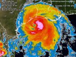
Hurricane Ike: As of 6 pm Eastern/5 pm Central Time, Ike was positioned near 28.2 North Latitude, 93.8 West Longitude or about 100 miles southeast of Galveston Texas.
Ike is expected to track between west-northwest and northwest right through landfall and this will bring the center of Ike very near, if not right over Galveston and then Ike will track up the west side of Galveston Bay and pretty much right over Houston. Based on Ike's forward speed of around 12 to 13 mph, landfall time appears to be sometime between 2 and 4 am Eastern/1 and 3 am Central Time early Saturday morning as a Category 3 hurricane with maximum winds of 115 to 125 mph.
The Hurricane Research Division has rated the surge Destructive Potential Rating on a scale of 0 to 6 as a 5.1 for surge destruction potential!!
Storm Surge Forecast: Water levels will continue to rise very rapidly tonight into early Saturday morning as the storm surge spreads onto the coast and Bayshore areas.
Maximum Storm Surge Forecast:
Texas:
Shoreline of Galveston Bay: 15 to 25 feet.
Bolivar Peninsula: 17 to 20 feet.
Galveston Island: 14 to 17 feet.
Gulf-facing coastline from Sargent to San Luis Pass: 8 to 13 feet.
Gulf-facing coastline west of Sargent: 4 to 7 feet.
Shoreline of Matagorda Bay: 3 to 6 feet.
Louisiana:
Coastal Cameron Parish: 15 to 18 Feet.
Coastal Vermilion, Iberia and St. Mary Parishes: 12 to 15 Feet.
Coastal Terrebonne Parish: 9 to 12 Feet.
Coastal Southeast Louisiana, including New Orleans: 4 to 9 Feet.
Mississippi coast: 4 to 8 Feet.
Alabama and Florida Panhandle: 3 to 6 Feet.
Wind Forecast: Hurricane force winds in excess of 74 mph will reach the coastal counties late this evening. These winds will spread inland through the Houston Metro area around midnight. Hurricane force winds may last for up to 12 hours.
Peak wind gusts of 90 to 110 mph will be possible across Harris, Liberty, Brazoria, Galveston and Chambers counties. Wind gusts near 115 mph will be possible near where the center of the storm comes onshore.
As for the Houston Metro area: Winds from Ike will probably be sustained at 85-90 mph at Houston Hobby on the south side of the city, and 75-80 mph at Houston International Airport on the north side of the city.
Inland Flooding: Widespread rainfall amounts of 5 to 7 inches with isolated rainfall totals of 10 to 12 inches will be possible through Saturday along the path of Ike. Significant river and stream flooding is possible in areas of heaviest rainfall.
Tornado Threat: The threat for tornadoes will exist through late Saturday in association with Ike. If a Tornado Warning is issued for your location, you should plan to seek shelter in an interior room on the lowest floor away from windows.
This is a very large hurricane in overall size. Tropical storm force winds extend outward up to 275 miles from the center of the storm and hurricane force winds extend outward up to 120 miles from the center of the storm. Ike's very strong winds, heavy rainfall and the threat for tornadoes will extend well inland due to the hurricane's accelerating speed at landfall. Damaging hurricane force winds are possible as far inland as 100 to 150 miles from the coast, roughly along and east of Interstate 45. Cities like Huntsville and Livingston to the north of Galveston will see hurricane force winds.
Tropical storm force winds will likely extend inland to Dallas, Tyler, Shreveport and quite possibly into southeastern Oklahoma and western Arkansas. It is very possible that Ike could cause widespread power outages over a 200 mile wide swath in eastern Texas and extreme western Louisiana and extending 300 miles inland to Interstate 20. Dallas may end up at the fringe of the region of widespread power outages, and should not suffer major power failures.
In conclusion, this is a VERY DANGEROUS hurricane. A Category 3 hurricane is forecast to make landfall very near Galveston, Texas between 2 and 4 am Eastern/1 and 3 am Central Time early Saturday morning. A large and destructive storm surge of up to 25 Feet will cross the middle and upper Texas coast.
This will be the last update on Hurricane Ike for today. I will issue a discussion updating all of you on Ike sometime during the day Saturday.
Prepared by Rob Lightbown, Crown Weather Services


 Yes, I see. You are definitely the Sassy in the better location!