
You are using an out of date browser. It may not display this or other websites correctly.
You should upgrade or use an alternative browser.
You should upgrade or use an alternative browser.
Solar Grand Solar Minimum part deux
- Thread starter Dennis Olson
- Start date
-
- Tags
- grand solar minimum
northern watch
TB Fanatic
The Little Ice Age and Beyond: Societal Impacts and Modeling the Long-Term Changes
RT: 1:03:38
I do not agree with the presenters view on what caused the Little Ice Age, CO2. What is more interesting is the impact the Little Ice Age had on society.
Last edited:
northern watch
TB Fanatic

Last edited:
northern watch
TB Fanatic

northern watch
TB Fanatic

TxGal
Day by day
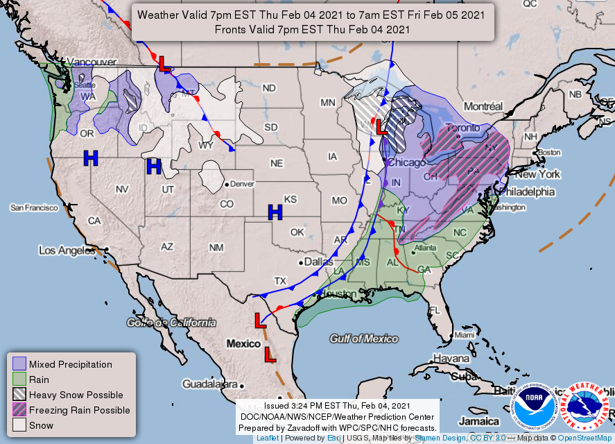
U.S. coast to coast record-setting storm -- Earth Changes -- Sott.net
U.S. coast to coast record-setting storm
Meredith Garofalo
Weather Nation
Thu, 04 Feb 2021 12:20 UTC

Destructive mudslides, feet of snow, wind and waves collapsing houses along the shoreline — all part of a powerful storm system that brought impacts coast to coast to close out the first month of the year.
We start in California with a tale of two different types of precipitation. While it was much needed moisture for the Golden State, it also brought hazards for days from the mountains to the beaches. Some cities picked up more than a foot of rain, leading to flooding and mudslides. This prompted evacuations and even rescue missions in Monterey County.
At the same time, mountain snow in the Sierras began coming down at a very fast rate, with final storm totals between six to nine feet. The snow engulfed towns, snarled traffic, and even stranded those brave enough to be out on the roads. From there, the storm system tracked toward the Midwest, with snow amounts measuring more than a foot in some locations from Milwaukee to Chicago to Northwest Indiana.
View: https://youtu.be/dO3ggRHrEks
Run time is 3:00
The snow set records for Chicago, IL, coming in as the largest snowfall event total in five years with 10.8" observed at Chicago O-Hare.
The final leg of its journey — bringing days of ice and snow into the Mid-Atlantic and Northeast. In the Big Apple, record setting daily snow totals rank this as one of the top 20 biggest snowstorms in recorded history.
In addition to snow, coastal cities had to brace for strong onshore winds that created large surf, which resulted in coastal flooding and significant beach erosion.
Homes were damaged and even destroyed with several in Sandwich, MA, collapsing into the ocean.
But while this historic winter storm brought lots of headaches, it also created happiness to those who needed an excuse to get outside and make the most of it.
This included a massive snowball fight in Washington, D.C. to several days of sledding ... and even building a snowman in Central Park.
U.S. coast to coast record-setting storm
Meredith Garofalo
Weather Nation
Thu, 04 Feb 2021 12:20 UTC

Destructive mudslides, feet of snow, wind and waves collapsing houses along the shoreline — all part of a powerful storm system that brought impacts coast to coast to close out the first month of the year.
We start in California with a tale of two different types of precipitation. While it was much needed moisture for the Golden State, it also brought hazards for days from the mountains to the beaches. Some cities picked up more than a foot of rain, leading to flooding and mudslides. This prompted evacuations and even rescue missions in Monterey County.
At the same time, mountain snow in the Sierras began coming down at a very fast rate, with final storm totals between six to nine feet. The snow engulfed towns, snarled traffic, and even stranded those brave enough to be out on the roads. From there, the storm system tracked toward the Midwest, with snow amounts measuring more than a foot in some locations from Milwaukee to Chicago to Northwest Indiana.
Run time is 3:00
The snow set records for Chicago, IL, coming in as the largest snowfall event total in five years with 10.8" observed at Chicago O-Hare.
The final leg of its journey — bringing days of ice and snow into the Mid-Atlantic and Northeast. In the Big Apple, record setting daily snow totals rank this as one of the top 20 biggest snowstorms in recorded history.
In addition to snow, coastal cities had to brace for strong onshore winds that created large surf, which resulted in coastal flooding and significant beach erosion.
Homes were damaged and even destroyed with several in Sandwich, MA, collapsing into the ocean.
But while this historic winter storm brought lots of headaches, it also created happiness to those who needed an excuse to get outside and make the most of it.
This included a massive snowball fight in Washington, D.C. to several days of sledding ... and even building a snowman in Central Park.
Last edited:
northern watch
TB Fanatic

northern watch
TB Fanatic
TxGal
Day by day
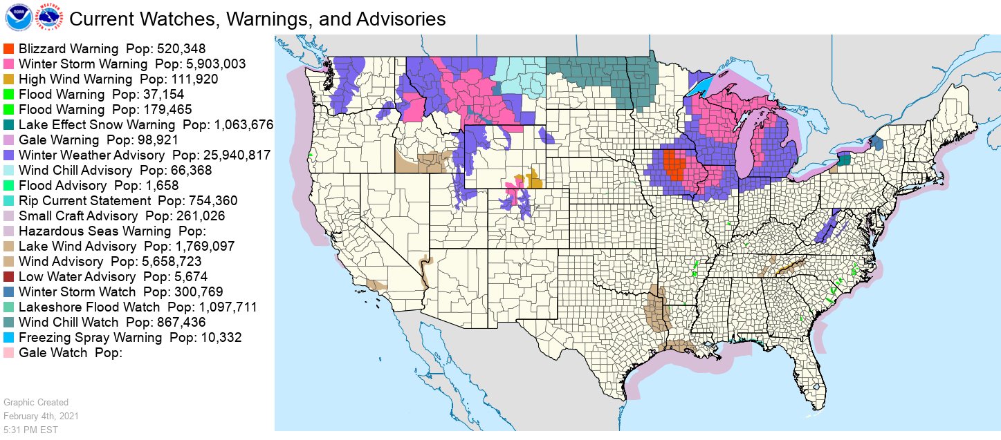
Major Arctic Outbreak for Central and Eastern U.S. - Temperatures 10-30 degrees below normal - Ice Age Now
Major Arctic Outbreak for Central and Eastern U.S. – Temperatures 10-30 degrees below normal
February 4, 2021 by Robert
Blizzard Warnings and Winter Weather Advisories effect from Iowa to the Great Lakes regions. “If you don’t need to travel, please stay put,” warns the NWS.
Blizzard warnings and temperatures 10-30 degrees below normal, and our government is foolishly fighting ‘global warming’?
______________
A strong cold front moving across the central U.S. today will bring areas of freezing rain, snow, and strong winds to the Midwest through the Great Lakes, says the National Weather Service. Blizzard conditions are expected for north-central Iowa.

A major Arctic outbreak will filter into the central and eastern U.S. in the wake of this front with temperatures 10-30 degrees below normal from the northern Plains to the Mid-South.
Winter Storm Impacting the Midwest and Great Lakes.
Heavy snow for the U.P. of Michigan and western Lower Michigan into Saturday.
Snow for the Cascades and the Northern/Central Rockies through Saturday.
Areas of rain/freezing rain from the Upper Midwest to the Lower Great Lakes/Northern New England through Saturday.

This is no joke,- Iowa – 4 Feb 2021
A cold front will continue to track from the entire Mississippi Valley Thursday evening across the East Friday before moving offshore by Saturday. Rain and snow associated with this system will also spread east along and ahead of the advancing boundary.
Winter Storm Warnings, Blizzard Warnings and Winter Weather Advisories are in effect from Iowa to the Great Lakes regions. Periods of heavy snowfall along with gusty winds will be possible, especially for portions of the northern Michigan and western Lower Michigan.
Out West, onshore flow over the Pacific Northwest will aid in producing coastal rain and higher elevation snow over through Saturday.
Meanwhile, Arctic high pressure will slowly sag southward into the northern-tier states bringing an abrupt change to daily temperatures for a large portion of the country.
Upslope flow associated with the high pressure will aid in producing snow over the Northern/Central Rockies and the Northern High Plains/Northern Plains through Saturday.
WPC's Short Range Public Discussion
Major Arctic Outbreak for Central and Eastern U.S. – Temperatures 10-30 degrees below normal
February 4, 2021 by Robert
Blizzard Warnings and Winter Weather Advisories effect from Iowa to the Great Lakes regions. “If you don’t need to travel, please stay put,” warns the NWS.
Blizzard warnings and temperatures 10-30 degrees below normal, and our government is foolishly fighting ‘global warming’?
______________
A strong cold front moving across the central U.S. today will bring areas of freezing rain, snow, and strong winds to the Midwest through the Great Lakes, says the National Weather Service. Blizzard conditions are expected for north-central Iowa.
A major Arctic outbreak will filter into the central and eastern U.S. in the wake of this front with temperatures 10-30 degrees below normal from the northern Plains to the Mid-South.
Winter Storm Impacting the Midwest and Great Lakes.
Heavy snow for the U.P. of Michigan and western Lower Michigan into Saturday.
Snow for the Cascades and the Northern/Central Rockies through Saturday.
Areas of rain/freezing rain from the Upper Midwest to the Lower Great Lakes/Northern New England through Saturday.
This is no joke,- Iowa – 4 Feb 2021
A cold front will continue to track from the entire Mississippi Valley Thursday evening across the East Friday before moving offshore by Saturday. Rain and snow associated with this system will also spread east along and ahead of the advancing boundary.
Winter Storm Warnings, Blizzard Warnings and Winter Weather Advisories are in effect from Iowa to the Great Lakes regions. Periods of heavy snowfall along with gusty winds will be possible, especially for portions of the northern Michigan and western Lower Michigan.
Out West, onshore flow over the Pacific Northwest will aid in producing coastal rain and higher elevation snow over through Saturday.
Meanwhile, Arctic high pressure will slowly sag southward into the northern-tier states bringing an abrupt change to daily temperatures for a large portion of the country.
Upslope flow associated with the high pressure will aid in producing snow over the Northern/Central Rockies and the Northern High Plains/Northern Plains through Saturday.
WPC's Short Range Public Discussion
TxGal
Day by day
From Adapt 2030:
Original Reset Safe Zone and Agricultural Land Grabs - YouTube
Original Reset Safe Zone and Agricultural Land Grabs
8,629 views • Feb 4, 2021
View: https://youtu.be/SW3TGPg5BQE
Run time is 17:58
Synopsis provided:
Where would one of the Grand Solar Minimum safe zones be, the answer is the exact spot a fertile land grab is happening in the Caucuses. Mt Ararat to the south flat plains and the first planting of vineyards spoken about through texts which has been in continuous production for 8000 years. History does repeat. Valuable land indeed.
Original Reset Safe Zone and Agricultural Land Grabs - YouTube
Original Reset Safe Zone and Agricultural Land Grabs
8,629 views • Feb 4, 2021
Run time is 17:58
Synopsis provided:
Where would one of the Grand Solar Minimum safe zones be, the answer is the exact spot a fertile land grab is happening in the Caucuses. Mt Ararat to the south flat plains and the first planting of vineyards spoken about through texts which has been in continuous production for 8000 years. History does repeat. Valuable land indeed.
TxGal
Day by day
From the Oppenheimer Ranch Project:
Record Breaking Snow In New Jersey - Infaltion Incoming - Jeff Bazos Opt's Out - Sign Of The Times - YouTube
Record Breaking Snow In New Jersey - Infaltion Incoming - Jeff Bazos Opt's Out - Sign Of The Times
4,605 views • Premiered Feb 4, 2021
View: https://youtu.be/P1M5NDJDn78
Run time is 11:55
Synopsis provided:
Record-Breaking Snow In The Long Valley Area? http://bit.ly/3cB9U8h
Record-Breaking Snow Fall In The Jefferson Area? http://bit.ly/39LJmiL
Here’s how much snow fell in Massachusetts on Feb. 1: As much as 24 inches recorded amid nor’easter http://bit.ly/3pRz1Yc
N.J. weather: New snowfall totals in every county, after epic winter storm finally tapers off http://bit.ly/3avdFJG
SNOWFALL ANALYSIS FROM THE LAST 72 HOURS http://bit.ly/37ZQHZh
A Winter Storm Impacting the Upper Midwest http://bit.ly/2p2GER3
GFS Model Total Snow US http://bit.ly/3pOUCjQ
GFS Model Total Snow Europe http://bit.ly/332e83w
Winds Challenge Crews Fighting Fire Near Perth, Australia http://bit.ly/2YF0EaW
Worldwide Volcano News http://bit.ly/2v9JJhO
This metric suggests there’s an economic boom ahead — and possibly inflation http://cnb.cx/3pOkBbp
Earth heats up due to pandemic’s cleaner air, study finds http://bit.ly/3pRzVUA
and more
Record Breaking Snow In New Jersey - Infaltion Incoming - Jeff Bazos Opt's Out - Sign Of The Times - YouTube
Record Breaking Snow In New Jersey - Infaltion Incoming - Jeff Bazos Opt's Out - Sign Of The Times
4,605 views • Premiered Feb 4, 2021
Run time is 11:55
Synopsis provided:
Record-Breaking Snow In The Long Valley Area? http://bit.ly/3cB9U8h
Record-Breaking Snow Fall In The Jefferson Area? http://bit.ly/39LJmiL
Here’s how much snow fell in Massachusetts on Feb. 1: As much as 24 inches recorded amid nor’easter http://bit.ly/3pRz1Yc
N.J. weather: New snowfall totals in every county, after epic winter storm finally tapers off http://bit.ly/3avdFJG
SNOWFALL ANALYSIS FROM THE LAST 72 HOURS http://bit.ly/37ZQHZh
A Winter Storm Impacting the Upper Midwest http://bit.ly/2p2GER3
GFS Model Total Snow US http://bit.ly/3pOUCjQ
GFS Model Total Snow Europe http://bit.ly/332e83w
Winds Challenge Crews Fighting Fire Near Perth, Australia http://bit.ly/2YF0EaW
Worldwide Volcano News http://bit.ly/2v9JJhO
This metric suggests there’s an economic boom ahead — and possibly inflation http://cnb.cx/3pOkBbp
Earth heats up due to pandemic’s cleaner air, study finds http://bit.ly/3pRzVUA
and more
TxGal
Day by day
Another from Oppenheimer:
The Great Grain Robbery 2021 - China Stuns Market With Monster Corn Purchases - Will History Repeat? - YouTube
The Great Grain Robbery 2021 - China Stuns Market With Monster Corn Purchases - Will History Repeat?
3,627 views • Premiered 7 hours ago
View: https://youtu.be/yPOq9CuTt-U
Run time is 8:38
Synopsis provided:
China stuns market with monster corn purchases http://bit.ly/3jjFfh2
Great Grain Robbery http://bit.ly/3rpqxbi
The Great Grain Robbery 2021 - China Stuns Market With Monster Corn Purchases - Will History Repeat? - YouTube
The Great Grain Robbery 2021 - China Stuns Market With Monster Corn Purchases - Will History Repeat?
3,627 views • Premiered 7 hours ago
Run time is 8:38
Synopsis provided:
China stuns market with monster corn purchases http://bit.ly/3jjFfh2
Great Grain Robbery http://bit.ly/3rpqxbi
TxGal
Day by day
And another from Oppenheimer:
40-Vehicle Pileup in Blizzard Shuts Down I-80 in Iowa - BOOM! - The Great Grain Robbery + More!! - YouTube
40-Vehicle Pileup in Blizzard Shuts Down I-80 in Iowa - BOOM! - The Great Grain Robbery + More!!
2,326 views • Premiered 6 hours ago
View: https://youtu.be/CHpNhYiXwl8
Run time is 11:58
Synopsis provided:
40-Vehicle Pileup in Blizzard Shuts Down I-80 in Iowa http://bit.ly/3cQdpHQ
Snowfall Totals Across Eastern Iowa from Today’s Winter Storm http://bit.ly/3rmMMON
This week's Northeastern snow storm was record-breaking http://bit.ly/2YNEQKs
Blowing snow continues to impact travel Friday http://bit.ly/3jhLHFr
Record Snow Reports Visual https://bit.ly/3avXUlM
Winter Snow Storm Was Among Biggest in NYC History http://nyti.ms/3aw5BrZ
Philly recorded 4 straight days of snow for just the 4th time ever and forecasters expect more http://bit.ly/2Lovh1q
GFS Model Total Snow US http://bit.ly/2MScDPQ
Sinabung volcano (Sumatra): eruption news and activity updates http://bit.ly/3roSCiR
Worldwide Volcano News http://bit.ly/2v9JJhO
Record-breaking roller coaster will travel more than 155 miles per hour http://cnn.it/3ribv6W
Largest Asteroid To Fly Past Earth in 2021 Is Moving 100 Times Faster Than Sound http://bit.ly/2O8vNBH
and more
40-Vehicle Pileup in Blizzard Shuts Down I-80 in Iowa - BOOM! - The Great Grain Robbery + More!! - YouTube
40-Vehicle Pileup in Blizzard Shuts Down I-80 in Iowa - BOOM! - The Great Grain Robbery + More!!
2,326 views • Premiered 6 hours ago
Run time is 11:58
Synopsis provided:
40-Vehicle Pileup in Blizzard Shuts Down I-80 in Iowa http://bit.ly/3cQdpHQ
Snowfall Totals Across Eastern Iowa from Today’s Winter Storm http://bit.ly/3rmMMON
This week's Northeastern snow storm was record-breaking http://bit.ly/2YNEQKs
Blowing snow continues to impact travel Friday http://bit.ly/3jhLHFr
Record Snow Reports Visual https://bit.ly/3avXUlM
Winter Snow Storm Was Among Biggest in NYC History http://nyti.ms/3aw5BrZ
Philly recorded 4 straight days of snow for just the 4th time ever and forecasters expect more http://bit.ly/2Lovh1q
GFS Model Total Snow US http://bit.ly/2MScDPQ
Sinabung volcano (Sumatra): eruption news and activity updates http://bit.ly/3roSCiR
Worldwide Volcano News http://bit.ly/2v9JJhO
Record-breaking roller coaster will travel more than 155 miles per hour http://cnn.it/3ribv6W
Largest Asteroid To Fly Past Earth in 2021 Is Moving 100 Times Faster Than Sound http://bit.ly/2O8vNBH
and more
TxGal
Day by day
"Rare" Snowfall Hits Maui for Fourth Year in a row - Electroverse

“RARE” SNOWFALL HITS MAUI FOR FOURTH YEAR IN A ROW
FEBRUARY 5, 2021 CAP ALLON
The summit district of Haleakalā National Park, Maui was closed on Feb. 3 and 4 due to rare wintry conditions and inches of snow, reports mauinow.com.
Rangers urged the public not to travel to the park, and closed both the road and entrance gate — locals were not permitted to see the snow or ice.
View: https://twitter.com/TLDAcademy/status/1357174627680677890
View: https://youtu.be/UQ6NEJ6OnaQ
Run time is 1:03
While snow occurs almost every year on the higher elevations of Hawai’i, flakes on the state’s smaller island of Maui are a much rarer sight, occurring on average just once every 5 years, according to the National Weather Service.
Astonishingly, 2021 is now (at least) the fourth year in a row that Maui has seen a wintry dusting, with impressive coverings also being documented in 2020, 2019, and 2018.
In fact, the island’s 2019 dusting was confirmed as the Hawaiian archipelago’s lowest elevation snowfall ever recorded, at 6,200 feet.
View: https://twitter.com/reelnewshawaii/status/1094760641158471681
Run time is 0:10
View: https://twitter.com/BillClintonTHOF/status/1095423274769620994
The trend is clear.
Hawaii is cooling…
View: https://twitter.com/theWeatherboy/status/1357403378612006912
…along with the planet:

 electroverse.net
The COLD TIMES are returning, the mid-latitudes are REFREEZING in line with the great conjunction, historically low solar activity, cloud-nucleating Cosmic Rays, and a meridional jet stream flow (among other forcings).
Both NOAA and NASA appear to agree, if you read between the lines, with NOAA saying we’re entering a ‘full-blown’ Grand Solar Minimum in the late-2020s, and NASA seeing this upcoming solar cycle (25) as “the weakest of the past 200 years”, with the agency correlating previous solar shutdowns to prolonged periods of global cooling here.
Furthermore, we can’t ignore the slew of new scientific papers stating the immense impact The Beaufort Gyre could have on the Gulf Stream, and therefore the climate overall.


Prepare accordingly— learn the facts, relocate if need be, and grow your own.
“RARE” SNOWFALL HITS MAUI FOR FOURTH YEAR IN A ROW
FEBRUARY 5, 2021 CAP ALLON
The summit district of Haleakalā National Park, Maui was closed on Feb. 3 and 4 due to rare wintry conditions and inches of snow, reports mauinow.com.
Rangers urged the public not to travel to the park, and closed both the road and entrance gate — locals were not permitted to see the snow or ice.
View: https://twitter.com/TLDAcademy/status/1357174627680677890
Run time is 1:03
While snow occurs almost every year on the higher elevations of Hawai’i, flakes on the state’s smaller island of Maui are a much rarer sight, occurring on average just once every 5 years, according to the National Weather Service.
Astonishingly, 2021 is now (at least) the fourth year in a row that Maui has seen a wintry dusting, with impressive coverings also being documented in 2020, 2019, and 2018.
In fact, the island’s 2019 dusting was confirmed as the Hawaiian archipelago’s lowest elevation snowfall ever recorded, at 6,200 feet.
View: https://twitter.com/reelnewshawaii/status/1094760641158471681
Run time is 0:10
View: https://twitter.com/BillClintonTHOF/status/1095423274769620994
The trend is clear.
Hawaii is cooling…
View: https://twitter.com/theWeatherboy/status/1357403378612006912
…along with the planet:
According to the Satellites, Earth has Cooled Rapidly during the past 2 Months - Electroverse
Our planet is colder TODAY than it was during much of the 2010s, the 2000s, large portions of the 1990s, as well as late-1987--and cooling!
The COLD TIMES are returning, the mid-latitudes are REFREEZING in line with the great conjunction, historically low solar activity, cloud-nucleating Cosmic Rays, and a meridional jet stream flow (among other forcings).
Both NOAA and NASA appear to agree, if you read between the lines, with NOAA saying we’re entering a ‘full-blown’ Grand Solar Minimum in the late-2020s, and NASA seeing this upcoming solar cycle (25) as “the weakest of the past 200 years”, with the agency correlating previous solar shutdowns to prolonged periods of global cooling here.
Furthermore, we can’t ignore the slew of new scientific papers stating the immense impact The Beaufort Gyre could have on the Gulf Stream, and therefore the climate overall.


Prepare accordingly— learn the facts, relocate if need be, and grow your own.
northern watch
TB Fanatic
China books biggest deal yet for U.S. corn
Reuters
Mark Weinraub and Karl Plume
Publishing date: Jan 29, 2021 • 6 days ago • 2 minute read
CHICAGO — China booked its biggest purchase of U.S. corn yet, the U.S. Agriculture Department said on Friday, buying more at once than any country except the Soviet Union 30 years ago, as it tries to meet a surge in demand for animal feed.
The purchase, and a string of deals earlier this week, mean China is on course to become the world’s largest corn importer.
Its buying spree has driven up global prices of corn and other grains and may stoke food inflation in economies already reeling from the COVID-19 pandemic.
USDA reported private sales of 2.108 million tonnes of corn for delivery to China in the 2020/21 marketing year. It was the second-biggest daily U.S. sale on record, eclipsed only by a deal for 3.72 million tonnes to the USSR in January 1991.
It also topped China’s previous biggest U.S. purchase of 1.937 million tonnes in July 2020.
China has been looking to boost corn imports, three industry sources told Reuters in October, after storms and drought damage tightened domestic supplies and as the country’s pork industry recovers from a deadly swine disease that reduced the hog herd by nearly half.
“Their hog herd has recovered faster than most had thought possible,” said Jack Scoville, analyst with Price Futures Group. “We’re making a new highs in futures so it’s not like they got a cheap deal. But when your domestic corn prices are north of $10 (a bushel) there’s certainly space for purchases.”
The latest sale follows deals earlier this week that netted China a combined 3.74 million tonnes of U.S. supplies, closing out what will be one of the largest U.S. corn export sales weeks on record.
Chinese buyers also picked up an additional 132,000 tonnes of soybeans – about two cargoes – for delivery in the 2021/22 marketing year, USDA said on Friday.
The country’s corn imports could climb to between 25 million and 27 million tonnes in the current crop year, including 18 to 20 million from the United States, president of AgResource Co, said on Wednesday.
If realized, that would make China the world’s biggest corn buyer. In the 2019/20 marketing year, Chinese corn imports totaled just 7.6 million tonnes.
This week’s sales bring China’s total U.S. corn import commitments for the current marketing year to at least 17.7 million tonnes, above the latest USDA forecast for only 17.5 million tonnes in imports from all suppliers.
The U.S. corn stockpile is large enough to meet the greater demand, analysts said.
The sales follow a steep drop in futures prices last week that opened up a buying opportunity for China, traders and analysts said, though prices rose again this week in response to the purchases.
Chicago Board of Trade corn futures were up 15 cents at $5.49-1/2 a bushel near midday on Friday, approaching the 7-1/2-year high hit on Thursday. (Reporting by Mark Weinraub and Karl Plume; editing by Barbara Lewis)
China books biggest deal yet for U.S. corn | Financial Post
northern watch
TB Fanatic
northern watch
TB Fanatic
Meteorologists Warn 'Deep Freeze' For The US Begins Next Week
BY TYLER DURDEN
ZERO HEDGE
FRIDAY, FEB 05, 2021 - 13:38
Readers may recall that natural gas prices erupted earlier in the week as weather models shifted to a much colder setup for the next two weeks.
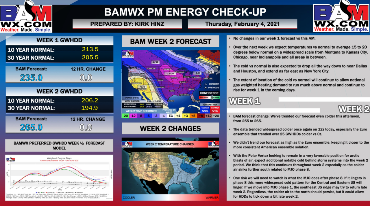
Expanding more on what's to come is BAMWX's meteorologist Kirk Hinz who published an in-depth update on Thursday describing how temperatures over the next couple of weeks will be well below average, thus boosting heating degree days, a sign that natgas demand will surge as people turn up their thermostats to stay warm.
For week one, Hinz outlines:
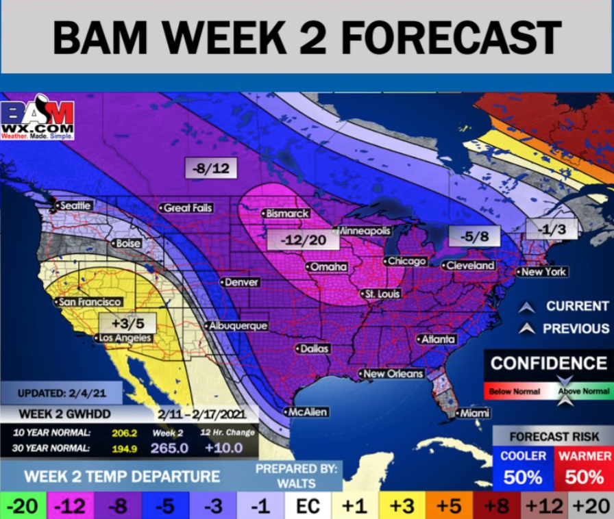
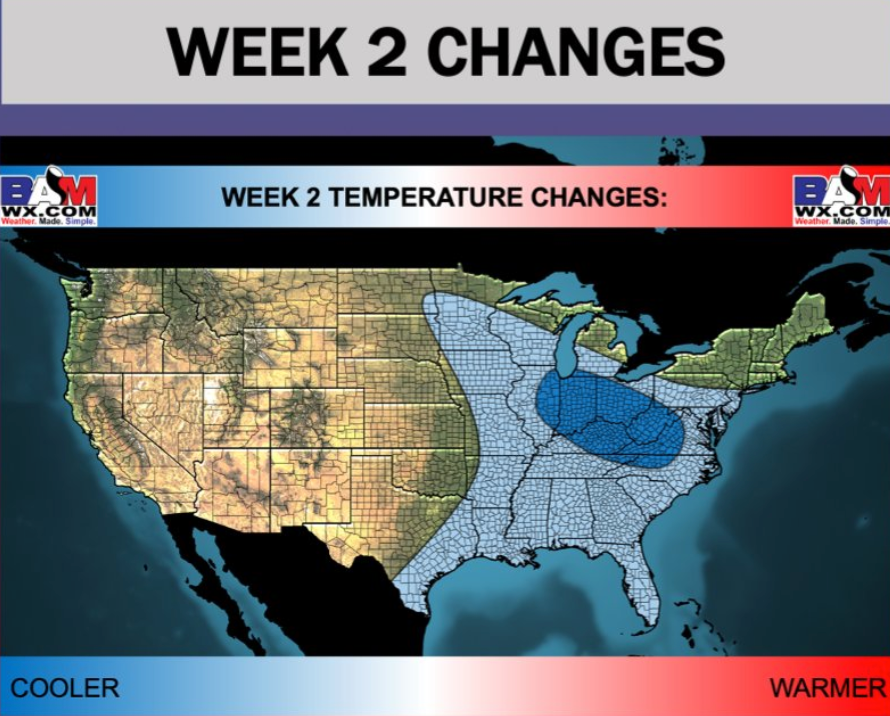
Much of the colder air for week 2 could be positioned across the US's central and eastern parts.
Heating degree days for weeks 1 and 2 show a large surge beginning early next week, which means it will take more energy to heat a residential or commercial structure as temperatures dive.
Natural-gas futures weekly hold above the 200 exponential moving average and have reclaimed the $3 handle on Friday morning.

Here's the full outlook:
Meteorologists Warn 'Deep Freeze' For The US Begins Next Week | ZeroHedge
BY TYLER DURDEN
ZERO HEDGE
FRIDAY, FEB 05, 2021 - 13:38
Readers may recall that natural gas prices erupted earlier in the week as weather models shifted to a much colder setup for the next two weeks.
Expanding more on what's to come is BAMWX's meteorologist Kirk Hinz who published an in-depth update on Thursday describing how temperatures over the next couple of weeks will be well below average, thus boosting heating degree days, a sign that natgas demand will surge as people turn up their thermostats to stay warm.
For week one, Hinz outlines:
- No changes in our week 1 forecast vs this AM.
- Over the next week we expect temperatures vs normal to average 15 to 20
- degrees below normal on a widespread scale from Montana to Kansas City, Chicago, near Indianapolis, and all areas in between.
- The cold vs normal is also expected to drop all the way down to near Dallas and Houston, and extend as far east as New York City.
- The extent of location of the cold vs normal will continue to allow national gas weighted heating demand to run much above normal and continue to rise for week 1 in the coming days.
- BAM forecast change: We've trended our forecast even colder this afternoon, from 255 to 265.
- The data trended widespread colder once again on 12z today, especially the Euro ensemble that trended over 25 GWHDDs colder vs Oz.
- We didn't trend our forecast as high as the Euro ensemble, keeping it closer to the more consistent American ensemble solution.
- With the Polar Vortex looking to remain in a very favorable position for arctic blasts of air, expect additional notable cold behind storm systems into the week 2 period. We think that this continues throughout week 2, especially as the colder air sinks further south related to MJO phase 8.
- One risk we will need to watch is what the MJO does after phase 8. If it lingers in phase 8 this more widespread cold pattern for the Central and Eastern US will linger. If we move Into MJO phase 1, the southeast US ridge may try to return late week 2. Regardless, the colder air to the north should persist, but it could allow for HDDs to tick down a bit late week 2.
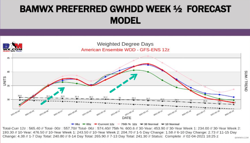
Much of the colder air for week 2 could be positioned across the US's central and eastern parts.
Heating degree days for weeks 1 and 2 show a large surge beginning early next week, which means it will take more energy to heat a residential or commercial structure as temperatures dive.
Natural-gas futures weekly hold above the 200 exponential moving average and have reclaimed the $3 handle on Friday morning.
Here's the full outlook:
Meteorologists Warn 'Deep Freeze' For The US Begins Next Week | ZeroHedge
Last edited:
northern watch
TB Fanatic
Germany braces for weather extremes: snowy north, warm south
Meteorologists say Germany faces rare weather extremes in the coming days, with large amounts of snow in the north and balmy temperatures in the south
By The Associated Press
5 February 2021, 10:02
")
 The Associated Press
A man takes pictures of the flooded meadows near the river Elbe in Dresden, Germany, Friday, Feb. 5, 2021. (Robert Michael/dpa via AP)
Meteorologists say Germany faces rare weather extremes in the coming days, with large amounts of snow in the north and balmy temperatures in the south.
The national weather service DWD said Friday that a polar vortex is pushing icy air from the Arctic toward northern Germany just as a low pressure front brings wet, warm weather from the southwest.
This could result in a sudden drop in temperatures Saturday, strong winds and heavy snowfall in regions that rarely get more than a sprinkling.
By early next week the temperature difference between the north and south of the country could be as big as 20 degrees Celsius (36 Fahrenheit), meteorologists said.
Mild weather in the south could fuel snowmelt in the mountains and further increase the risk of flooding.
Several rivers in Germany burst their banks this week and persistent rainfall has led to numerous mudslides.
Germany braces for weather extremes: snowy north, warm south - ABC News (go.com)
Meteorologists say Germany faces rare weather extremes in the coming days, with large amounts of snow in the north and balmy temperatures in the south
By The Associated Press
5 February 2021, 10:02
A man takes pictures of the flooded meadows near the river Elbe in Dresden, Germany, Friday, Feb. 5, 2021. (Robert Michael/dpa via AP)
Meteorologists say Germany faces rare weather extremes in the coming days, with large amounts of snow in the north and balmy temperatures in the south.
The national weather service DWD said Friday that a polar vortex is pushing icy air from the Arctic toward northern Germany just as a low pressure front brings wet, warm weather from the southwest.
This could result in a sudden drop in temperatures Saturday, strong winds and heavy snowfall in regions that rarely get more than a sprinkling.
By early next week the temperature difference between the north and south of the country could be as big as 20 degrees Celsius (36 Fahrenheit), meteorologists said.
Mild weather in the south could fuel snowmelt in the mountains and further increase the risk of flooding.
Several rivers in Germany burst their banks this week and persistent rainfall has led to numerous mudslides.
Germany braces for weather extremes: snowy north, warm south - ABC News (go.com)
TxGal
Day by day
Weekend: Widespread Arctic Air And Possible Winter System - Ice Age Now
Weekend: Widespread Arctic Air And Possible Winter System
February 5, 2021 by Robert
An arctic air mass with frigid temperatures and life-threatening wind chills is expected to consume much of the northern Plains and Upper Midwest into the Great Lakes and Ohio Valley this weekend. Widespread wind chill warnings and advisories are already in effect. Meanwhile, heavy snow may hit weekend from the central Plains into portions of the East.
According to the NWS Weather Prediction Center College Park, Maryland, multiple rounds of heavy snow are on the way for the Cascades and Northern/Central Rockies & Plains, with life-threatening wind chills entering the Northern Plains tonight.
Heavy lake effect snow is likely through Saturday across the eastern shores of the Great Lakes.
Heavy snow possible from the Central Appalachians to the Northeast I-95 corridor.
Periods of snow from the northern Rockies and Plains to the central Plains this weekend.
Current moderate-to-heavy snowfall in Montana and the central Rockies tracks into the central Plains tonight.
Winter Weather Advisories are in place for much of Nebraska and northeast Kansas through Saturday morning where 3 to 6 inches of snow are forecast.
Meanwhile comes another round of moderate-to-heavy snow in the northern Rockies and Plains. Winter Storm Warnings are in place for parts of Montana into Sunday afternoon.
By Sunday evening, snowfall will likely be measured in feet along the highest elevations of the Cascades, Bitterroots, and northern Rockies.
In addition to the snow, bitterly cold temperatures and dangerous wind chills will be common in the northern Plains and Upper Midwest this weekend.
High temperatures will struggle to get above zero Fahrenheit (-17.8C) from Montana and North Dakota to Minnesota both Saturday and Sunday with wind chills potentially as low as -50F (-45.8C) degrees.
This has resulted in Wind Chill Warnings for northern North Dakota and Minnesota, while bone-chilling wind chills are also expected within counties under Wind Chill Advisories that span from eastern Montana to northwest Wisconsin.
Over the Great Lakes, brisk and persistent westerly winds and bitter temperatures support favorable conditions for lake effect snow in the typical snowbelts. The lake effect snow machine continues to pump out bands of heavy snowfall when conditions are ripe due to ice coverage across the Great Lakes being well below average.
Weekend snowfall totals are likely to include several inches of snow along the western shores of Michigan with as much as 6 to 12 inches (locally higher amounts possible)
downwind of Lakes Erie and Ontario.
Precipitation looks to fall in the form of snow from the southern Appalachians to the Mid-Atlantic. There is still some uncertainty, but the latest forecast calls for snow, falling heavily at times, from the DC/Baltimore metro areas up the I-95 corridor to southern New England on Sunday.
Snowfall totals could range anywhere from a couple inches to as much as 6 inches in the higher elevations of the central Appalachians.
Winter Storm Watches have been issued from western North Carolina and southwest Virginia to portions of the Northeast I-95 corridor.
WPC's Short Range Public Discussion
TxGal
Day by day
Snowed in! Family opens front door to discover 9 foot wall of snow in Glenrinnes, Scotland -- Earth Changes -- Sott.net
Family opens front door to discover 9 foot wall of snow in Glenrinnes, Scotland
Chris MacLennan
The Press and Journal
Fri, 05 Feb 2021 13:10 UTC

© Laurie Robertson
The snow wall that greets the Robertson Family
Usually, it's the neighbours that come knocking, however, a huge snow wall has formed outside the front door of this Moray family's home - completely blocking access.
The Robertsons from Glenrinnes have watched as snow crept closer towards their home over the last few days.
And now, after several heavy drifts, the family are now unable to use their front door.
Mum Laurie Robertson took to social media to share images of the entrance to her house completely blocked.
Mrs Robertson said: "We are up one of the back roads so if there is snow, more often than not its drifts if there is any wind.
View: https://youtu.be/gBu2wudy9GY
Run time is 0:44
Family opens front door to discover 9 foot wall of snow in Glenrinnes, Scotland
Chris MacLennan
The Press and Journal
Fri, 05 Feb 2021 13:10 UTC

© Laurie Robertson
The snow wall that greets the Robertson Family
Usually, it's the neighbours that come knocking, however, a huge snow wall has formed outside the front door of this Moray family's home - completely blocking access.
The Robertsons from Glenrinnes have watched as snow crept closer towards their home over the last few days.
And now, after several heavy drifts, the family are now unable to use their front door.
Mum Laurie Robertson took to social media to share images of the entrance to her house completely blocked.
Mrs Robertson said: "We are up one of the back roads so if there is snow, more often than not its drifts if there is any wind.
Run time is 0:44
northern watch
TB Fanatic

northern watch
TB Fanatic
northern watch
TB Fanatic
Flooding hits some French towns as water recedes elsewhere
Floodwaters that devastated vineyards and orchards are receding in southwest France but rising elsewhere, including in a French town where people were evacuated from flooded homes
By The Associated Press
6 February 2021, 10:54

The Associated Press
A volunteer walks through water on a flooded road in Coussan, near Marmande southwestern France, Saturday, Feb. 6, 2021. Rivers across France broke their banks this week amid heavy flooding. In southern France, waters are starting to recede after the worst flooding in 40 years swelled the Garonne River between Bordeaux and Toulouse. Vineyards and orchards turned into lakes, and rescue boats floated along small-town streets. (AP Photo/Bob Edme)
PARIS -- Floodwaters that devastated vineyards and orchards receded Saturday in southwest France but rose elsewhere, including in a French town where people were evacuated from flooded homes.
In the Paris region, the Seine River overflowed its embankments for a fifth day. The Marne River to the east inundated several towns, including Lagny-Sur-Marne.
In the western town of Saintes, north of Bordeaux, the Charente River flooded dozens of streets and homes, and was expected to keep rising. Mayor Bruno Drapron called on authorities to declare a natural disaster, an action that would facilitate aid and insurance payments.
The 95 inmates at Sainte's 19th century prison were evacuated Friday as a preventive measure and placed in other facilities, officials said.
Scores of residents were evacuated from their homes and more than 2,000 could be if the water doesn't stop rising, according to information on the town hall's website. The local government requisitioned a hotel and opened a welcome center in a cultural center housed in a historic abbey, according to regional radio station France Bleu.
Further south, waters receded after the worst flooding in 40 years swelled the Garonne River between Bordeaux and Toulouse. Vineyards and orchards turned into lakes, and rescue boats floated along small-town streets.
Prime Minister Jean Castex visited the flood-battered town of Marmande in the region Friday and promised “the solidarity of the state for all those who suffered.”
Flooding hits some French towns as water recedes elsewhere - ABC News (go.com)
Floodwaters that devastated vineyards and orchards are receding in southwest France but rising elsewhere, including in a French town where people were evacuated from flooded homes
By The Associated Press
6 February 2021, 10:54
A volunteer walks through water on a flooded road in Coussan, near Marmande southwestern France, Saturday, Feb. 6, 2021. Rivers across France broke their banks this week amid heavy flooding. In southern France, waters are starting to recede after the worst flooding in 40 years swelled the Garonne River between Bordeaux and Toulouse. Vineyards and orchards turned into lakes, and rescue boats floated along small-town streets. (AP Photo/Bob Edme)
PARIS -- Floodwaters that devastated vineyards and orchards receded Saturday in southwest France but rose elsewhere, including in a French town where people were evacuated from flooded homes.
In the Paris region, the Seine River overflowed its embankments for a fifth day. The Marne River to the east inundated several towns, including Lagny-Sur-Marne.
In the western town of Saintes, north of Bordeaux, the Charente River flooded dozens of streets and homes, and was expected to keep rising. Mayor Bruno Drapron called on authorities to declare a natural disaster, an action that would facilitate aid and insurance payments.
The 95 inmates at Sainte's 19th century prison were evacuated Friday as a preventive measure and placed in other facilities, officials said.
Scores of residents were evacuated from their homes and more than 2,000 could be if the water doesn't stop rising, according to information on the town hall's website. The local government requisitioned a hotel and opened a welcome center in a cultural center housed in a historic abbey, according to regional radio station France Bleu.
Further south, waters receded after the worst flooding in 40 years swelled the Garonne River between Bordeaux and Toulouse. Vineyards and orchards turned into lakes, and rescue boats floated along small-town streets.
Prime Minister Jean Castex visited the flood-battered town of Marmande in the region Friday and promised “the solidarity of the state for all those who suffered.”
Flooding hits some French towns as water recedes elsewhere - ABC News (go.com)
northern watch
TB Fanatic

northern watch
TB Fanatic

northern watch
TB Fanatic
Skiing on dust, is not my idea of skiing
Martinhouse
Deceased
One winter, in perhaps the mid-'70s, when I still lived in a suburb of Minneapolis, we had a snow and then an all-night wind. The next day our snow was brown on top and we heard on the radio that parts of the Dakotas west of us has been blown completely bare of their snow and that brown on our snow was Dakota soil. At the time it was a really strange feeling to know that.
TxGal
Day by day
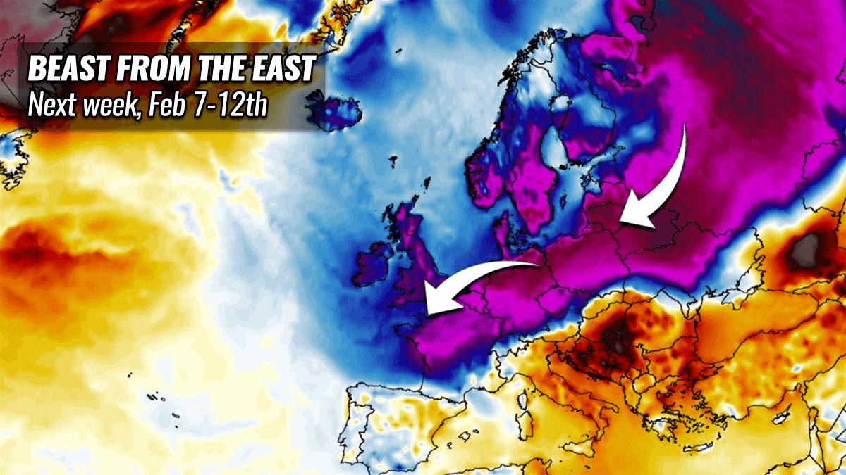
Beast from the East set to release extreme cold and snow over Europe next week
February 6, 2021 by Robert
“Looks like Europe will finally be experiencing more winter weather as we head into early February,” writes Marko Korosec.
“What weather models are hinting at lately is a severe cold outbreak setting up this weekend into next week. A so-called Beast from the East will push extreme cold and also develop some snow towards the west and south.
“The weather models do hint that the European continent is setting a stage for a potentially quite significant cold outbreak, spreading into Scandinavia this week and then also towards western and central Europe early next week.
“Once the cold reaches higher moisture further south, winter storms are likely to form and bring snow for some regions. One frontal wave will cross eastern Europe on Thursday, with one system also over the UK.
“Another, a potentially more significant snowstorm is forecast across central and western Europe over the weekend into early next week.”
 www.severe-weather.eu
February 6, 2021 by Robert
“Looks like Europe will finally be experiencing more winter weather as we head into early February,” writes Marko Korosec.
“What weather models are hinting at lately is a severe cold outbreak setting up this weekend into next week. A so-called Beast from the East will push extreme cold and also develop some snow towards the west and south.
“The weather models do hint that the European continent is setting a stage for a potentially quite significant cold outbreak, spreading into Scandinavia this week and then also towards western and central Europe early next week.
“Once the cold reaches higher moisture further south, winter storms are likely to form and bring snow for some regions. One frontal wave will cross eastern Europe on Thursday, with one system also over the UK.
“Another, a potentially more significant snowstorm is forecast across central and western Europe over the weekend into early next week.”
Finally: Beast from the East set to release extreme cold and snow over Europe next week
A cold outbreak is setting up for next week as a so-called Beast from the East will push extreme cold and also some snow towards the central-west Europe.
www.severe-weather.eu
TxGal
Day by day
Bitter Cold and Wintry Weather from the Northern Rockies to the Great Lakes - Ice Age Now
Bitter Cold and Wintry Weather from the Northern Rockies to the Great Lakes
February 6, 2021 by Robert
Heavy snow from the Northern Rockies through the Plains and into the Midwest today.
Dangerous wind chills will continue across the Upper Midwest through the weekend.
Frigid air will spread from Alberta down into Montana into the central Great Plains and Ohio Valley, then gradually work south all the way to the southern tip of Texas and the southern borders of Louisiana and Mississippi through next week. Strong storms are also possible over Florida today into Sunday.
According to BAMWX meteorologist Kirk Hinz temperatures over the next couple of weeks will run well below average, thus boosting heating degree days, a sign that natural gas demand will surge as people turn up their thermostats to stay warm.
By “well below average,” Hinz means that temperatures will easily run 15 to to 20 degrees below normal on a widespread scale from Montana to Bismarck, Omaha, Minneapolis, Kansas City, Chicago, Cleveland, Indianapolis, and extend as far east as New York City and all areas in between.
He expects temperatures to run 8 to 12 degrees below normal far south as Dallas, New Orleans and Atlanta.
Hinz expects the bitter cold will remain for at least two weeks.
“With the Polar Vortex looking to remain in a very favorable position for arctic blasts of air, expect additional notable cold behind storm systems into the week 2 period,” says Hinz. “We think that this continues throughout week 2, especially as the colder air sinks further south.”
As they shiver under their blankets trying to keep warm, I wonder how many people will appreciate their government’s foolish attempts to force them into submission concerning “global warming”?
Meteorologists Warn 'Deep Freeze' For The US Begins Next Week | ZeroHedge
TxGal
Day by day
Most snow for over a decade at closed Scottish ski centres -- Earth Changes -- Sott.net
Most snow for over a decade at closed Scottish ski centres
Patrick Thorne
Inthesnow.com
Sat, 06 Feb 2021 12:17 UTC

Scotland's sensational winter for snowfall is continuing, with what is now, after nearly two months of largely sub-zero temperatures, one of the longest spells of cold snowy weather this century.
Many are comparing this winter to the 'big freeze' of 2010, but there seems to be more snowfall so far than that famously cold, but rather dry winter.
The country's five commercial ski centres are all currently closed as part of the Scottish lockdown and that currently looks set to be the case for the rest of February at least.
View: https://youtu.be/HGJnIcs29vQ
Run time is 6:10

The ski areas have been posting pictures of just how much snow is now lying, with most seeing their access roads buried. Pictured above is Cairngorm above Aviemore on Saturday 6th February. The groomer is clearing the road up to the closed centre.
Even before the full lockdown began, most Scottish ski areas were only accessible to skiers based in the local regions where they are located under the country's tiered system. Things may revert to that scenario in the spring, but for now nothing is certain.
However, although Scotland's weather can see sudden temperature rises, the current hope is that this amount of snow will mean it is possible for the season to continue late in to spring, if the centres are allowed to reopen.

Glencoe
With such amazing snow conditions ski touring is proving popular, but there's a warning of high avalanche danger, and the fact that travelling any distance to go ski touring breaks lockdown rules with the police already fining some transgressors, including some that required mountain rescue services.
This winter is very different to recent seasons, particularly last season 2019-20 when it was mostly warm, wet and windy - apart from a few good weekends in the west - until the spring, when it was consistently colder and snowier ...just as the first lockdown was announced.
The Lecht published the image below of their groomer attempting to find the buried road there in late January.

Most snow for over a decade at closed Scottish ski centres
Patrick Thorne
Inthesnow.com
Sat, 06 Feb 2021 12:17 UTC

Scotland's sensational winter for snowfall is continuing, with what is now, after nearly two months of largely sub-zero temperatures, one of the longest spells of cold snowy weather this century.
Many are comparing this winter to the 'big freeze' of 2010, but there seems to be more snowfall so far than that famously cold, but rather dry winter.
The country's five commercial ski centres are all currently closed as part of the Scottish lockdown and that currently looks set to be the case for the rest of February at least.
Run time is 6:10

The ski areas have been posting pictures of just how much snow is now lying, with most seeing their access roads buried. Pictured above is Cairngorm above Aviemore on Saturday 6th February. The groomer is clearing the road up to the closed centre.
Even before the full lockdown began, most Scottish ski areas were only accessible to skiers based in the local regions where they are located under the country's tiered system. Things may revert to that scenario in the spring, but for now nothing is certain.
However, although Scotland's weather can see sudden temperature rises, the current hope is that this amount of snow will mean it is possible for the season to continue late in to spring, if the centres are allowed to reopen.

Glencoe
With such amazing snow conditions ski touring is proving popular, but there's a warning of high avalanche danger, and the fact that travelling any distance to go ski touring breaks lockdown rules with the police already fining some transgressors, including some that required mountain rescue services.
This winter is very different to recent seasons, particularly last season 2019-20 when it was mostly warm, wet and windy - apart from a few good weekends in the west - until the spring, when it was consistently colder and snowier ...just as the first lockdown was announced.
The Lecht published the image below of their groomer attempting to find the buried road there in late January.

nomifyle
TB Fanatic
I'm in north central Louisiana and its predicted to be in the 20's over night for three or four days and maybe some snow. We can use the cold lower temps to kill off fleas and that crap that grows in our lakes. We did a cold cold a few weeks ago and snow but it didn't quite kill of the crap in the lakes.
Be prepared for what ever comes your way.
God is good all the time.
Judy
Be prepared for what ever comes your way.
God is good all the time.
Judy
northern watch
TB Fanatic
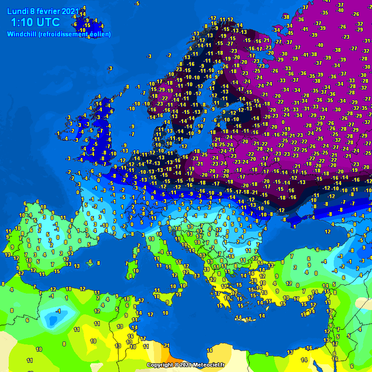
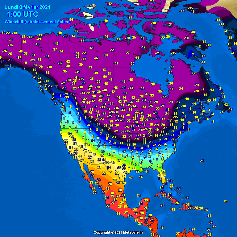
The temperatures on the maps are in degrees C
northern watch
TB Fanatic

northern watch
TB Fanatic
northern watch
TB Fanatic
northern watch
TB Fanatic
northern watch
TB Fanatic

northern watch
TB Fanatic
This is what I expect The Grand Solar Minimum to do