You are using an out of date browser. It may not display this or other websites correctly.
You should upgrade or use an alternative browser.
You should upgrade or use an alternative browser.
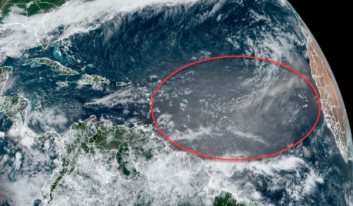
Solar Grand Solar Minimum part deux
- Thread starter Dennis Olson
- Start date
-
- Tags
- grand solar minimum
northern watch
TB Fanatic
TxGal
Day by day
Gettin' seriously real, isn't it?
I really think it is...sigh.
I've been trying to do this reply for gosh, ages. Satellite internet and tv keeps going out. We've had severe thunderstorms in the area, at one point the clouds were tinted green even though the warnings were just to our north by about 20 miles. I think we got lucky. Just a LOT of torrential rain...so far. I don't think it's over yet. Big cold front is pushing down into our area and dropping temps a lot, hence the nasty storms. It's getting old, but I guess I'd best get used to it. I think this is our new normal, cold fronts dropping in with a lot of ugly.
TxGal
Day by day
The Oppenheimer Ranch Project has two new podcasts, here's one:
RARE Mothers Day Snow Hits Ohio and PA - Massive Snow For Colorado - C-Flare = Earth Facing CME - YouTube
RARE Mothers Day Snow Hits Ohio and PA - Massive Snow For Colorado - C-Flare = Earth Facing CME
3,358 views • Premiered 8 hours ago
View: https://youtu.be/Tcb0uWAJRSo
Run time is 17:54
Synopsis provided:
Snow and slush hit Northeast Ohio on Mother's Day https://bit.ly/3ttkhQp
Mother’s Day snow hits northern Pa. https://bit.ly/33u4lTh
May 8 Storm Damage Reports https://bit.ly/3y1CV56
4-6 inches possible in SE Wyoming https://bit.ly/3xZMNwj
Heavy snow predicted for mountains https://bit.ly/3tzaEj8
Winter Storm Warning In Hawaii https://bit.ly/3o1YRIQ
SNOWFALL ANALYSIS FROM THE LAST 24 HOURS https://www.weather.gov/crh/snowfall
GFS Model Total Snow US https://bit.ly/3euKzgS
Worldwide Volcano News http://bit.ly/2v9JJhO
Scientists Track Mauna Loa Summit Changes https://bit.ly/3tyMULY
PROF. FRITZ VAHRENHOLT: SOLAR-INDUCED COOLING *THIS DECADE* IS OUR ONLY HOPE AGAINST DANGEROUS CO2-REDUCING POLICIES https://bit.ly/3beervT
GOES X-Ray Flux http://bit.ly/38EqTBu
ISWA CYGNET STREAMER https://go.nasa.gov/2R8QL1h
A filament located near center disk erupted beginning at 10:00 UTC today (May 9). Here is a look at the event using the SDO/AIA 304a channel https://www.solarham.net/
Filament Eruption (5/9/2021) - SDO/AIA https://bit.ly/3vYPFI9
SOHO Movie Maker https://soho.nascom.nasa.gov/data/The...
Live volcanic eruption in Iceland! - Monday 10th - FLOcam https://bit.ly/2OnlbiK
Evolutionary Dispute: Most Human Origins Stories Are Not Compatible With Known Fossils https://bit.ly/33uMMm6
Scientists Find 40,000-Year-Old Star Maps Featuring ‘Sophisticated Knowledge of Constellations’ https://bit.ly/2Q6kUle
Filament Eruption Followed By A Long Duration C-Class Solar Flare = CME Headed Our Way On May 12th https://www.youtube.com/watch?v=V4eRy...
RARE Mothers Day Snow Hits Ohio and PA - Massive Snow For Colorado - C-Flare = Earth Facing CME - YouTube
RARE Mothers Day Snow Hits Ohio and PA - Massive Snow For Colorado - C-Flare = Earth Facing CME
3,358 views • Premiered 8 hours ago
Run time is 17:54
Synopsis provided:
Snow and slush hit Northeast Ohio on Mother's Day https://bit.ly/3ttkhQp
Mother’s Day snow hits northern Pa. https://bit.ly/33u4lTh
May 8 Storm Damage Reports https://bit.ly/3y1CV56
4-6 inches possible in SE Wyoming https://bit.ly/3xZMNwj
Heavy snow predicted for mountains https://bit.ly/3tzaEj8
Winter Storm Warning In Hawaii https://bit.ly/3o1YRIQ
SNOWFALL ANALYSIS FROM THE LAST 24 HOURS https://www.weather.gov/crh/snowfall
GFS Model Total Snow US https://bit.ly/3euKzgS
Worldwide Volcano News http://bit.ly/2v9JJhO
Scientists Track Mauna Loa Summit Changes https://bit.ly/3tyMULY
PROF. FRITZ VAHRENHOLT: SOLAR-INDUCED COOLING *THIS DECADE* IS OUR ONLY HOPE AGAINST DANGEROUS CO2-REDUCING POLICIES https://bit.ly/3beervT
GOES X-Ray Flux http://bit.ly/38EqTBu
ISWA CYGNET STREAMER https://go.nasa.gov/2R8QL1h
A filament located near center disk erupted beginning at 10:00 UTC today (May 9). Here is a look at the event using the SDO/AIA 304a channel https://www.solarham.net/
Filament Eruption (5/9/2021) - SDO/AIA https://bit.ly/3vYPFI9
SOHO Movie Maker https://soho.nascom.nasa.gov/data/The...
Live volcanic eruption in Iceland! - Monday 10th - FLOcam https://bit.ly/2OnlbiK
Evolutionary Dispute: Most Human Origins Stories Are Not Compatible With Known Fossils https://bit.ly/33uMMm6
Scientists Find 40,000-Year-Old Star Maps Featuring ‘Sophisticated Knowledge of Constellations’ https://bit.ly/2Q6kUle
Filament Eruption Followed By A Long Duration C-Class Solar Flare = CME Headed Our Way On May 12th https://www.youtube.com/watch?v=V4eRy...
TxGal
Day by day
Here's the other from Oppenheimer:
Filament Eruption Followed By A Long Duration C-Class Solar Flare = CME Headed Our Way On May 12th - YouTube
Filament Eruption Followed By A Long Duration C-Class Solar Flare = CME Headed Our Way On May 12th
2,979 views •Premiered 10 hours ago
View: https://youtu.be/V4eRy71aX0Y
Run time is 5:15
Synopsis provided:
A filament located near center disk erupted beginning at 10:00 UTC today (May 9). Imagery courtesy of STEREO Ahead shows a coronal mass ejection (CME) leaving the Sun and could possibly have an Earth directed component. https://www.solarham.net/
It should also be noted that a long duration C-Class eruption was observed around AR 2822 and Is associated with a CME. Impacts due on May 12th. https://www.solarham.net/
Filament Eruption (5/9/2021) - SDO/AIA https://bit.ly/3vYPFI9
ISWA CYGNET STREAMER PREDICTION https://go.nasa.gov/2R8QL1h
GOES X-Ray Flux http://bit.ly/38EqTBu
SOHO Movie Maker https://soho.nascom.nasa.gov/data/The...
Filament Eruption Followed By A Long Duration C-Class Solar Flare = CME Headed Our Way On May 12th - YouTube
Filament Eruption Followed By A Long Duration C-Class Solar Flare = CME Headed Our Way On May 12th
2,979 views •Premiered 10 hours ago
Run time is 5:15
Synopsis provided:
A filament located near center disk erupted beginning at 10:00 UTC today (May 9). Imagery courtesy of STEREO Ahead shows a coronal mass ejection (CME) leaving the Sun and could possibly have an Earth directed component. https://www.solarham.net/
It should also be noted that a long duration C-Class eruption was observed around AR 2822 and Is associated with a CME. Impacts due on May 12th. https://www.solarham.net/
Filament Eruption (5/9/2021) - SDO/AIA https://bit.ly/3vYPFI9
ISWA CYGNET STREAMER PREDICTION https://go.nasa.gov/2R8QL1h
GOES X-Ray Flux http://bit.ly/38EqTBu
SOHO Movie Maker https://soho.nascom.nasa.gov/data/The...
TxGal
Day by day
Mother's Day was a Record-Breaker: Rare Cold and Snow Blasts America - Electroverse

Extreme Weather GSM
MOTHER’S DAY WAS A RECORD-BREAKER: RARE COLD AND SNOW BLASTS AMERICA
MAY 10, 2021 CAP ALLON
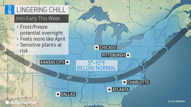
April in the U.S. came out colder than normal (despite what NOAA say), which has extended the nation’s stark cooling trend observed over the past five years. And now, into the second week of May, the Arctic is still refusing to abate as it delivers record low temperatures and record mid-spring snow to many states.
A fresh round of unseasonable polar chills is plunging southward as I type.
Here’s your Monday evening, America:

GFS 2m Temp Anomalies for May 10 [tropicaltidbits.com].
These forecast temperature anomalies are staggering.
States such as Texas, Oklahoma, Colorado and Kansas are set to suffer departures some 20C below the seasonal norm, perhaps even more in exposed spots — but the entire CONUS (excluding Florida and eastern Cali) will be hit.
The cold is expected to prove persist, too, lingering through midweek from the Rockies and Plains to the South and East.
Many states should brace for rare May freezes, with unprecedented snowfall to boot:

GFS Total Snowfall (inches) May 10 – May 12 [tropicaltidbits.com].
And already, states such as Pennsylvania are reporting inches of mid-spring snow.
Flakes settled along the I-80 in central PA on Sunday, May 9: “impressive yet pretty ridiculous at the same time,” said one local driver.
“Nothing like snow for Mother’s Day,” said John Hickey on Twitter:
View: https://twitter.com/JohnWNEP/status/1391510618587414535
Across vast portions of North America, rare May snowfall is settling.
Confirmed reports of are coming in from states and provinces such as Ohio, Montana, Alberta, Ontario, and even New York.
Below was the scene in Northeast Ohio Sunday afternoon:
http://instagr.am/p/COqUgPznokZ/ View: https://www.instagram.com/p/COqUgPznokZ/?utm_source=ig_web_copy_link
Run time unknown
The MSM is blaming this rare phenomenon on blocking in Greenland, which, although true, isn’t the full story.
CBS News writes:
“You may have noticed that cool temperatures have been slow to lessen their grip this spring. That’s because there is an atmospheric condition that meteorologists call a blocking pattern near Greenland. This is when a ridge of high pressure — you can think of it as a mountain of warm air in the atmosphere — gets stuck over the Polar regions of eastern Canada and the North Atlantic. The result is cold pockets of air that would normally be way up north get pushed out and displaced south across the northern U.S. This stubborn pattern has been around since the beginning of April. In fact, we can trace this pattern all the way back into winter when Texas and the Central U.S. suffered with historic cold. In climate, these blocky patterns are sometimes tough to break down, especially when they are as robust as what we saw this past winter.”
This is a perfectly accurate summary, but CBS stops short of informing its readers of the cause.
Research shows “blocking persistence” increases when solar activity is low, and that this blocking can lead to weather patterns becoming locked in-place at high and intermediate latitudes for prolonged periods of time.
During a Solar Minimum –such as the one we’re still struggling to escape from now (of SC24)– the jet stream’s usual Zonal Flow (a west–east direction) reverts to more of a Meridional Flow (a north-south direction).
This pattern exaggerated further during a Grand Solar Minimum, and explains why regions become unseasonably hot or cold and others unusually dry or rainy for extended periods of time.
In one recent paper, Mikhaël Schwander, et al discuss the setup as it pertains to Europe:
The paper goes further:
The setup is the same for the U.S., you simply replace “Scandinavia” with “Greenland.”
Furthermore, this low solar activity / colder conditions theory is a robust one (unlike CO2 / warmth).
The Northeast was struck by a very similar snowy setup back in 1977 — that year fell during the very weak Solar Minimum of cycle 20.
On the evening of Sunday, May 8, 1977, a mass of unseasonably cold, Canadian air wrapped itself around a developing storm and produced a cold rain which ultimately changed over to heavy, wet snow — the heaviest to have ever fallen in May.
You can pinpoint the Solar Minimum of cycle 20 in the ‘Sunspot Number’ chart below.
Note that cycle 20 was indeed weak, but also that is hasn’t a patch on the cycle we’re exiting now (24) which more closely resembles those of the Centennial Minimum (SC12, SC13, & SC14)
Looking ahead, most solar forecasts see SC25 being just as weak as SC24, with SC26 (due to commence around 2031) potentially rivaling the cycles of the Dalton Minimum (SC5, SC6, & SC7), and even the Maunder Minimum before it (1645-1715) where the Sun was devoid of sunspots for years an even decades at a time.

And finally, winter storm watches were issued in Hawaii late last week.
According to the National Weather Service: “A Winter Storm Watch means there is potential for significant snow or ice accumulations that may impact the summits. Anyone planning travel to the summits should consider postponing their trip until improved weather returns.”
To repeat, that’s a winter storm watch, in Hawaii, in May:
View: https://twitter.com/TylerWSFA12/status/1390424144278339585
The COLD TIMES are returning, the mid-latitudes are REFREEZING, in line with the great conjunction, historically low solar activity, cloud-nucleating Cosmic Rays, and a meridional jet stream flow (among other forcings).
Both NOAA and NASA appear to agree, if you read between the lines, with NOAA saying we’re entering a ‘full-blown’ Grand Solar Minimum in the late-2020s, and NASA seeing this upcoming solar cycle (25) as “the weakest of the past 200 years”, with the agency correlating previous solar shutdowns to prolonged periods of global cooling here.
Furthermore, we can’t ignore the slew of new scientific papers stating the immense impact The Beaufort Gyre could have on the Gulf Stream, and therefore the climate overall.


Prepare accordingly— learn the facts, relocate if need be, and grow your own.
Extreme Weather GSM
MOTHER’S DAY WAS A RECORD-BREAKER: RARE COLD AND SNOW BLASTS AMERICA
MAY 10, 2021 CAP ALLON
April in the U.S. came out colder than normal (despite what NOAA say), which has extended the nation’s stark cooling trend observed over the past five years. And now, into the second week of May, the Arctic is still refusing to abate as it delivers record low temperatures and record mid-spring snow to many states.
A fresh round of unseasonable polar chills is plunging southward as I type.
Here’s your Monday evening, America:

GFS 2m Temp Anomalies for May 10 [tropicaltidbits.com].
These forecast temperature anomalies are staggering.
States such as Texas, Oklahoma, Colorado and Kansas are set to suffer departures some 20C below the seasonal norm, perhaps even more in exposed spots — but the entire CONUS (excluding Florida and eastern Cali) will be hit.
The cold is expected to prove persist, too, lingering through midweek from the Rockies and Plains to the South and East.
Many states should brace for rare May freezes, with unprecedented snowfall to boot:

GFS Total Snowfall (inches) May 10 – May 12 [tropicaltidbits.com].
And already, states such as Pennsylvania are reporting inches of mid-spring snow.
Flakes settled along the I-80 in central PA on Sunday, May 9: “impressive yet pretty ridiculous at the same time,” said one local driver.
“Nothing like snow for Mother’s Day,” said John Hickey on Twitter:
View: https://twitter.com/JohnWNEP/status/1391510618587414535
Across vast portions of North America, rare May snowfall is settling.
Confirmed reports of are coming in from states and provinces such as Ohio, Montana, Alberta, Ontario, and even New York.
Below was the scene in Northeast Ohio Sunday afternoon:
http://instagr.am/p/COqUgPznokZ/ View: https://www.instagram.com/p/COqUgPznokZ/?utm_source=ig_web_copy_link
Run time unknown
The MSM is blaming this rare phenomenon on blocking in Greenland, which, although true, isn’t the full story.
CBS News writes:
“You may have noticed that cool temperatures have been slow to lessen their grip this spring. That’s because there is an atmospheric condition that meteorologists call a blocking pattern near Greenland. This is when a ridge of high pressure — you can think of it as a mountain of warm air in the atmosphere — gets stuck over the Polar regions of eastern Canada and the North Atlantic. The result is cold pockets of air that would normally be way up north get pushed out and displaced south across the northern U.S. This stubborn pattern has been around since the beginning of April. In fact, we can trace this pattern all the way back into winter when Texas and the Central U.S. suffered with historic cold. In climate, these blocky patterns are sometimes tough to break down, especially when they are as robust as what we saw this past winter.”
This is a perfectly accurate summary, but CBS stops short of informing its readers of the cause.
Research shows “blocking persistence” increases when solar activity is low, and that this blocking can lead to weather patterns becoming locked in-place at high and intermediate latitudes for prolonged periods of time.
During a Solar Minimum –such as the one we’re still struggling to escape from now (of SC24)– the jet stream’s usual Zonal Flow (a west–east direction) reverts to more of a Meridional Flow (a north-south direction).
This pattern exaggerated further during a Grand Solar Minimum, and explains why regions become unseasonably hot or cold and others unusually dry or rainy for extended periods of time.
In one recent paper, Mikhaël Schwander, et al discuss the setup as it pertains to Europe:
“The zonal flow characteristic of westerly types is reduced under low solar activity as the continental flow for easterly and northerly types is enhanced. This is also confirmed by the higher blocking frequency over Scandinavia under low solar activity.”
The paper goes further:
“The 247-year-long analysis of the 11-year solar cycle impact on late winter European weather patterns suggests a reduction in the occurrence of westerly flow types linked to a reduced mean zonal flow under low solar activity. Based on this observational evidence, we estimate the probability to have cold conditions in winter over Europe to be higher under low solar activity than under high activity.”
The setup is the same for the U.S., you simply replace “Scandinavia” with “Greenland.”
Furthermore, this low solar activity / colder conditions theory is a robust one (unlike CO2 / warmth).
The Northeast was struck by a very similar snowy setup back in 1977 — that year fell during the very weak Solar Minimum of cycle 20.
On the evening of Sunday, May 8, 1977, a mass of unseasonably cold, Canadian air wrapped itself around a developing storm and produced a cold rain which ultimately changed over to heavy, wet snow — the heaviest to have ever fallen in May.
You can pinpoint the Solar Minimum of cycle 20 in the ‘Sunspot Number’ chart below.
Note that cycle 20 was indeed weak, but also that is hasn’t a patch on the cycle we’re exiting now (24) which more closely resembles those of the Centennial Minimum (SC12, SC13, & SC14)
Looking ahead, most solar forecasts see SC25 being just as weak as SC24, with SC26 (due to commence around 2031) potentially rivaling the cycles of the Dalton Minimum (SC5, SC6, & SC7), and even the Maunder Minimum before it (1645-1715) where the Sun was devoid of sunspots for years an even decades at a time.

And finally, winter storm watches were issued in Hawaii late last week.
According to the National Weather Service: “A Winter Storm Watch means there is potential for significant snow or ice accumulations that may impact the summits. Anyone planning travel to the summits should consider postponing their trip until improved weather returns.”
To repeat, that’s a winter storm watch, in Hawaii, in May:
View: https://twitter.com/TylerWSFA12/status/1390424144278339585
The COLD TIMES are returning, the mid-latitudes are REFREEZING, in line with the great conjunction, historically low solar activity, cloud-nucleating Cosmic Rays, and a meridional jet stream flow (among other forcings).
Both NOAA and NASA appear to agree, if you read between the lines, with NOAA saying we’re entering a ‘full-blown’ Grand Solar Minimum in the late-2020s, and NASA seeing this upcoming solar cycle (25) as “the weakest of the past 200 years”, with the agency correlating previous solar shutdowns to prolonged periods of global cooling here.
Furthermore, we can’t ignore the slew of new scientific papers stating the immense impact The Beaufort Gyre could have on the Gulf Stream, and therefore the climate overall.


Prepare accordingly— learn the facts, relocate if need be, and grow your own.
TxGal
Day by day
Mass deaths of reindeer on Yamal peninsula in Russia might be linked to climate change, scientists believe -- Earth Changes -- Sott.net
Mass deaths of reindeer on Yamal peninsula in Russia might be linked to climate change, scientists believe
The Siberian Times
Mon, 10 May 2021 12:53 UTC

© Arctic Lab Yamal
First reports about winter rains followed by lengthy spells of extremely cold weather on Yamal appeared in December 2020.
Thousands of domestic and wild animals perished because they couldn't get to forage locked under ice.
New ideas to rescue reindeer herding are urgently needed for the Yamal peninsula, said members of the scientific expedition that just returned from the trip to its northern tundra.
'The perished reindeer were observed all around the northern tundra, among them were wild reindeer who also suffered from icing and lack of forage. Herders showed us that their hooves were worn out because they had to dig through ice so much', said researchers Alexandra Terekhina and Alexander Volkovitsky from the Arctic Research Station in Labytnangi, part of the Institute of Plant and Animal Ecology.
View: https://youtu.be/fMZmQXFO6h4
Run time is 0:09
First reports about winter rains followed by lengthy spells of extremely cold weather on Yamal appeared in December 2020.
Alarmed herders said the unusual weather caused formation of thick - up to three centimetres - ice cover over lichen.
For reindeer, this means an impossible task to reach forage as they graze winter pastures, which is why hooves were so badly worn out on the dead animals seen by the scientists.
Some of the Yamal peninsula's domestic animals left traditional winter pastures and followed wild reindeer hoping to survive.
By spring the number of animals that could have died from starvation was estimated in thousands.
'We are clearly speaking of thousands of animals, but there is no exact number of the perished reindeer yet, because the herders are still roaming the Seyakhinskaya tundra as they try to gather the herds together.
Overall there are around 65,000 reindeer in this northern part of the peninsula's tundra. Not all of them were on the iced territory', explained Alexandra Terekhina.
The last devastating loss of domestic and wild reindeer on the Yamal peninsula was in winter 2013-2014, when up to 90,000 animals starved to death in three districts of the Yamalo-Nenets Autonomous District.
The ecologists believe that changing climate may have caused the deadly mix of weather events like thin snow cover, followed by winter rains and then days of severe frosts.

© Arctic Lab Yamal
'Our team made several trips to study snow profiles to the north of Sabetta and in the tundra between Labytnangi and Sabetta. We studied layers of ice covering soil and vegetation, and saw that all dark lichen hilltops and slopes with little snow were also covered with ice', said Alexander Volkovitsky.
While periodic glaciation is typical for the Yamal peninsula, scientists believe that the changing climate might be affecting its frequency, and causing it to happen more often.
Mass death of reindeer caused by the similar combination of rain followed by cold weather was recently reported thousands of miles south-east from Yamal on the Kamchatka Peninsula. At least 300 animals died at the northwests of the peninsula because they couldn't get to food through the layer of ice and snow.
Several other cases of mass reindeer deaths caused by icy rains were reported this year in Norway and Sweden, with local authorities sending tonnes of forage to affected Arctic areas, and drafting programs of government support to herders.
Similar support like free delivery of reindeer food and gasoline for snowmobiles has been provided to herders by Yamalsky district and Seyakha village administrations since last December.
'We've got to think of radically new solutions. By reindeer herders' terms, the Yamal peninsula is quite populated, and there aren't that many spare herding areas. Also, and possibly this might be the main issue, since Soviet times reindeer herders who populated the northern, Seyakhinskaya tundra, were limited to that area only, while in the past they were moving herds to forest areas for winters,' said Alexandra Terekhina.
Mass deaths of reindeer on Yamal peninsula in Russia might be linked to climate change, scientists believe
The Siberian Times
Mon, 10 May 2021 12:53 UTC

© Arctic Lab Yamal
First reports about winter rains followed by lengthy spells of extremely cold weather on Yamal appeared in December 2020.
Thousands of domestic and wild animals perished because they couldn't get to forage locked under ice.
New ideas to rescue reindeer herding are urgently needed for the Yamal peninsula, said members of the scientific expedition that just returned from the trip to its northern tundra.
'The perished reindeer were observed all around the northern tundra, among them were wild reindeer who also suffered from icing and lack of forage. Herders showed us that their hooves were worn out because they had to dig through ice so much', said researchers Alexandra Terekhina and Alexander Volkovitsky from the Arctic Research Station in Labytnangi, part of the Institute of Plant and Animal Ecology.
Run time is 0:09
First reports about winter rains followed by lengthy spells of extremely cold weather on Yamal appeared in December 2020.
Alarmed herders said the unusual weather caused formation of thick - up to three centimetres - ice cover over lichen.
For reindeer, this means an impossible task to reach forage as they graze winter pastures, which is why hooves were so badly worn out on the dead animals seen by the scientists.
Some of the Yamal peninsula's domestic animals left traditional winter pastures and followed wild reindeer hoping to survive.
By spring the number of animals that could have died from starvation was estimated in thousands.
'We are clearly speaking of thousands of animals, but there is no exact number of the perished reindeer yet, because the herders are still roaming the Seyakhinskaya tundra as they try to gather the herds together.
Overall there are around 65,000 reindeer in this northern part of the peninsula's tundra. Not all of them were on the iced territory', explained Alexandra Terekhina.
The last devastating loss of domestic and wild reindeer on the Yamal peninsula was in winter 2013-2014, when up to 90,000 animals starved to death in three districts of the Yamalo-Nenets Autonomous District.
The ecologists believe that changing climate may have caused the deadly mix of weather events like thin snow cover, followed by winter rains and then days of severe frosts.

© Arctic Lab Yamal
'Our team made several trips to study snow profiles to the north of Sabetta and in the tundra between Labytnangi and Sabetta. We studied layers of ice covering soil and vegetation, and saw that all dark lichen hilltops and slopes with little snow were also covered with ice', said Alexander Volkovitsky.
While periodic glaciation is typical for the Yamal peninsula, scientists believe that the changing climate might be affecting its frequency, and causing it to happen more often.
Mass death of reindeer caused by the similar combination of rain followed by cold weather was recently reported thousands of miles south-east from Yamal on the Kamchatka Peninsula. At least 300 animals died at the northwests of the peninsula because they couldn't get to food through the layer of ice and snow.
Several other cases of mass reindeer deaths caused by icy rains were reported this year in Norway and Sweden, with local authorities sending tonnes of forage to affected Arctic areas, and drafting programs of government support to herders.
Similar support like free delivery of reindeer food and gasoline for snowmobiles has been provided to herders by Yamalsky district and Seyakha village administrations since last December.
'We've got to think of radically new solutions. By reindeer herders' terms, the Yamal peninsula is quite populated, and there aren't that many spare herding areas. Also, and possibly this might be the main issue, since Soviet times reindeer herders who populated the northern, Seyakhinskaya tundra, were limited to that area only, while in the past they were moving herds to forest areas for winters,' said Alexandra Terekhina.
I can't remember the exact year, but we had a foot of snow on Mother's Day, May 10th... I think it was around 2008? Anyway, that was different... we had been having wonderful weather, Temps in the 80s, everything was in full bloom.
Then there was 2009... it hit 22 degrees May 24th... every bit of fruit in the county was killed.
This feels different, though... its just staying cold and wet...
Summerthyme
Then there was 2009... it hit 22 degrees May 24th... every bit of fruit in the county was killed.
This feels different, though... its just staying cold and wet...
Summerthyme
TxGal
Day by day
Europe's Extreme May Freeze is set to Continue - Electroverse

Extreme Weather GSM
EUROPE’S EXTREME MAY FREEZE IS SET TO CONTINUE
MAY 10, 2021 CAP ALLON
Near-term models don’t know whether they’re coming or going. This meridional jet stream flow is throwing them for a loop. And after fooling many MSM publications into running headlines such as “Intense 10 day Heatwave set to strike Europe,” the models have now flipped, and are forecasting yet more Arctic cold.
Below was the scene on May 8 in northern England:
View: https://twitter.com/AmandaOwen8/status/1391128760943104001
Run time is 0:18
“May time blizzard makes us shiver,” tweeted the YorkshireSpeherdess, who runs a successful sheep farm.
“You can’t believe this is May,” she says in the video.
“It’s just like the middle of winter.”
View: https://twitter.com/AmandaOwen8/status/1390990230518439937
Run time is 0:21
Paul Simons’ Weather Eye article from the Saturday Times compared England’s recent May snowfall to that 1821:

Simons writes:
He continues:
Note, the year 1821 lands within the Solar Minimum of Cycle 6 — a historically weak solar cycle, one that occurred during the Dalton Minimum (1790-1830):

[@ClimateRealists]

 electroverse.net
As of today, May 10, central Europe is actually enjoying a spell of spring warmth.
However, the spell will prove fleeting, lasting just two-days, and the region will be returned to winter starting Tuesday, May 11.
And then by Thursday, May 13, temperature anomalies will nosedive further again, reaching levels some 10C to 12C below the seasonal average across the majority of the continent:

GFS 2m temp Anomalies May 13 (purples indicate 10C below average) [tropicaltidbits.com].
Additional heavy snow will also strike, particularly in the Alps, Scandinavia, and the Spanish mountains:

GFS Total Snowfall (cm) May 10 – May 24.
These cold and unsettled conditions are forecast to persist through the next week-or-so, before yet another round of ‘Arctic shock therapy’ threatens to wake the masses from their manufactured global warming psychosis, on May 20:

GFS 2m temp Anomalies May 20 [tropicaltidbits.com].
The below animated model run is within the unreliable time-frame (however, the GFS has been largely successful with its cold projections so far this year). What the run shows is that there could be a further deepening of the cold as we near the end of May — a jaw-dropping scenario, if forecasts pan out:

GFS 2m temp Anomalies May 20 – May 25 [tropicaltidbits.com].
Europe is experiencing a historically cold spring, perhaps even its coldest on record.
England, for example, has just suffered its chilliest April since 1922, and now –as of May 9– is on for its coldest May since record keeping began back in 1659–yes, that’s 362 years ago, during the Maunder Minimum.
 electroverse.net
And the situation is the same across the pond, too…
electroverse.net
…as low solar activity continues to cool the planet:
 electroverse.net
The COLD TIMES are returning, the mid-latitudes are REFREEZING, in line with the great conjunction, historically low solar activity, cloud-nucleating Cosmic Rays, and a meridional jet stream flow (among other forcings).
Both NOAA and NASA appear to agree, if you read between the lines, with NOAA saying we’re entering a ‘full-blown’ Grand Solar Minimum in the late-2020s, and NASA seeing this upcoming solar cycle (25) as “the weakest of the past 200 years”, with the agency correlating previous solar shutdowns to prolonged periods of global cooling here.
Furthermore, we can’t ignore the slew of new scientific papers stating the immense impact The Beaufort Gyre could have on the Gulf Stream, and therefore the climate overall.
Prepare accordingly— learn the facts, relocate if need be, and grow your own.
Extreme Weather GSM
EUROPE’S EXTREME MAY FREEZE IS SET TO CONTINUE
MAY 10, 2021 CAP ALLON
Near-term models don’t know whether they’re coming or going. This meridional jet stream flow is throwing them for a loop. And after fooling many MSM publications into running headlines such as “Intense 10 day Heatwave set to strike Europe,” the models have now flipped, and are forecasting yet more Arctic cold.
Below was the scene on May 8 in northern England:
View: https://twitter.com/AmandaOwen8/status/1391128760943104001
Run time is 0:18
“May time blizzard makes us shiver,” tweeted the YorkshireSpeherdess, who runs a successful sheep farm.
“You can’t believe this is May,” she says in the video.
“It’s just like the middle of winter.”
View: https://twitter.com/AmandaOwen8/status/1390990230518439937
Run time is 0:21
Paul Simons’ Weather Eye article from the Saturday Times compared England’s recent May snowfall to that 1821:

Simons writes:
“This is late spring, less than seven weeks away from the summer solstice … Although the weather is freakish, snow has fallen in May before, although it is unusual for the snow to settle on the ground and for their to be enough to ski on.”
He continues:
“One historic May snowfall was 200 years ago and it came late in the month, on May 27, 1821. The Leeds Intelligencer reported: On Friday night, the thermometer fell 2 degrees below the freezing point; and on Saturday we had a fall of snow.“
Note, the year 1821 lands within the Solar Minimum of Cycle 6 — a historically weak solar cycle, one that occurred during the Dalton Minimum (1790-1830):

[@ClimateRealists]
2021 in Europe: "The Year Without a Spring" - Electroverse
Low solar activity is prolonging winter, which is having an impact on harvests across the N. Hemisphere. GSM. Prepare.
As of today, May 10, central Europe is actually enjoying a spell of spring warmth.
However, the spell will prove fleeting, lasting just two-days, and the region will be returned to winter starting Tuesday, May 11.
And then by Thursday, May 13, temperature anomalies will nosedive further again, reaching levels some 10C to 12C below the seasonal average across the majority of the continent:

GFS 2m temp Anomalies May 13 (purples indicate 10C below average) [tropicaltidbits.com].
Additional heavy snow will also strike, particularly in the Alps, Scandinavia, and the Spanish mountains:

GFS Total Snowfall (cm) May 10 – May 24.
These cold and unsettled conditions are forecast to persist through the next week-or-so, before yet another round of ‘Arctic shock therapy’ threatens to wake the masses from their manufactured global warming psychosis, on May 20:

GFS 2m temp Anomalies May 20 [tropicaltidbits.com].
The below animated model run is within the unreliable time-frame (however, the GFS has been largely successful with its cold projections so far this year). What the run shows is that there could be a further deepening of the cold as we near the end of May — a jaw-dropping scenario, if forecasts pan out:

GFS 2m temp Anomalies May 20 – May 25 [tropicaltidbits.com].
Europe is experiencing a historically cold spring, perhaps even its coldest on record.
England, for example, has just suffered its chilliest April since 1922, and now –as of May 9– is on for its coldest May since record keeping began back in 1659–yes, that’s 362 years ago, during the Maunder Minimum.
England is on for its Coldest May since Record-Keeping Began back in 1659 (during the Maunder Minimum) - Electroverse
Following its coldest APRIL since 1922, England is now on for its coldest MAY since record-keeping began some 362 years ago.
And the situation is the same across the pond, too…
Mother's Day was a Record-Breaker: Rare Cold and Snow Blasts America - Electroverse
States such as Pennsylvania and New York are reporting inches of mid-spring snow, with record-accumulations on the way for the likes of Colorado and Wyoming.
…as low solar activity continues to cool the planet:
It's Getting Harder and Harder to Maintain the Lie: Global Temperatures Sink Further in April - Electroverse
It takes a tumultuous event to awake the masses from their manufactured psychosis. Perhaps 'global cooling' is that event.
The COLD TIMES are returning, the mid-latitudes are REFREEZING, in line with the great conjunction, historically low solar activity, cloud-nucleating Cosmic Rays, and a meridional jet stream flow (among other forcings).
Both NOAA and NASA appear to agree, if you read between the lines, with NOAA saying we’re entering a ‘full-blown’ Grand Solar Minimum in the late-2020s, and NASA seeing this upcoming solar cycle (25) as “the weakest of the past 200 years”, with the agency correlating previous solar shutdowns to prolonged periods of global cooling here.
Furthermore, we can’t ignore the slew of new scientific papers stating the immense impact The Beaufort Gyre could have on the Gulf Stream, and therefore the climate overall.
Prepare accordingly— learn the facts, relocate if need be, and grow your own.
TxGal
Day by day
Hungary records its coldest April of the 21st century -- Earth Changes -- Sott.net
Hungary records its coldest April of the 21st century
Hungary Today
Mon, 10 May 2021 13:27 UTC

© György Varga/MTI
April this year was the coldest this century, and it was the 15th coldest since 1901, Hungary's weather service said on Sunday.
The month was 2.9 C. cooler than the average of 11.4 C. recorded between 1991 and 2020, the service said on its website and on Instagram.
April was especially capricious this year, witnessing snow and even snowdrifts.
Several other records were also broken during the month, with 80.7mm of rain drenching Tokaj, in eastern Hungary, on the first day of the month, while in Budapest, the record for the hottest day (26.1 C.) was broken on the same day.
On April 15, the coldest day, the mercury did not get above -0.6 C. in Kekesteto in the north of the country.
TxGal
Day by day
April was Colder than Average across the U.S., NOAA are lying - here's the Proof: - Electroverse

Articles
APRIL WAS COLDER THAN AVERAGE ACROSS THE U.S., NOAA ARE LYING — HERE’S THE PROOF:
MAY 10, 2021 CAP ALLON
NOAA are known obfuscaters and downright dirty data-tamperers. They have been caught cooking the books on multiple occasions, and the excuses they give are about as embarrassing as their forecasts.
Just as they were in February, the National Oceanic and Atmospheric Administration (NOAA) was confident of a hot April across the United States:

But just as occurred in February, NOAA was proven hopefully wrong by real-world observations.
As exposed by Tony Heller (in the below chart), the agency’s own thermometer data shows that this year’s April mean temperature was well-below the average and continued the overall cooling trend observed since 1895:

The average April mean temperature in the US.
April 2021’s minimum temperature was also well-below the average.
And note that just three years ago the United State’s was experiencing its coldest April in recorded history:

The average April minimum temperature in the US.
Given all this official thermometer data, let’s see what NOAA had to say in their April 2021 climate report:

April 2021 was “a bit warm for much of the U.S.,” reads the agency’s headline.
NOAA created their imaginary April warmth by tampering with the data, like they do every month, says Heller.
And this is clearly visible in the animation below.
The first image is the raw “measured” thermometer data, while the second image is after NOAA got its sticky, data-fudging fingers involved, and it shows the officially “reported” temperatures:

Measured temps vs Reported temps [Tony Heller].
It doesn’t get any more clear-cut than this.
The narrative must be maintained, at the expense of the facts and all notions of credibility.
Money and power are strong motivators.
The masses are being lied to, yet are completely oblivious. They are so clueless, in fact, that many are vehemently aboard the ‘climate catastrophe train,’ next stop socialism and global governance!
 electroverse.net
The next and final chart reveals the percent of April days above 70F (21.1C) at all US weather stations.
Heller wants you to note that April temperatures have plummeted over the past 20 years:

So much for anthropogenic global warming.
The CO2 / temperature correlation is debunked by real-world observations each and every day.
In fact, it has been debunked on each and every day for the past 362 years.
The oldest temperature dataset on the planet is the Central England Temperature (CET) record which has been running since 1659.
What the CET reveals is that there has never been any direct correlation between rising CO2 emissions and temperatures:

[c3headlines.com].
The above chart plots the rolling 30-year changes in CET temperatures vs atmospheric CO2 levels.
The data clearly shows that temperatures have always been highly variable, and recent temperature changes are hardly unprecedented, as is the claim of those face-painting hippies.
This lack of unprecedented modern temperature change is further exposed by the blue curve, a 10-year average of the 30-year temperature changes. And, it’s visually obvious that past annual temperature changes were far more extreme prior to the modern increase in atmospheric CO2 levels.
The AGW hypothesis is a failed hypothesis, and it needs dumping before it does anymore damage:
 electroverse.net
The COLD TIMES are returning, the mid-latitudes are REFREEZING, in line with the great conjunction, historically low solar activity, cloud-nucleating Cosmic Rays, and a meridional jet stream flow (among other forcings).
Both NOAA and NASA appear to agree, if you read between the lines, with NOAA saying we’re entering a ‘full-blown’ Grand Solar Minimum in the late-2020s, and NASA seeing this upcoming solar cycle (25) as “the weakest of the past 200 years”, with the agency correlating previous solar shutdowns to prolonged periods of global cooling here.
Furthermore, we can’t ignore the slew of new scientific papers stating the immense impact The Beaufort Gyre could have on the Gulf Stream, and therefore the climate overall.
Prepare accordingly— learn the facts, relocate if need be, and grow your own.
Articles
APRIL WAS COLDER THAN AVERAGE ACROSS THE U.S., NOAA ARE LYING — HERE’S THE PROOF:
MAY 10, 2021 CAP ALLON
NOAA are known obfuscaters and downright dirty data-tamperers. They have been caught cooking the books on multiple occasions, and the excuses they give are about as embarrassing as their forecasts.
Just as they were in February, the National Oceanic and Atmospheric Administration (NOAA) was confident of a hot April across the United States:

But just as occurred in February, NOAA was proven hopefully wrong by real-world observations.
As exposed by Tony Heller (in the below chart), the agency’s own thermometer data shows that this year’s April mean temperature was well-below the average and continued the overall cooling trend observed since 1895:

The average April mean temperature in the US.
April 2021’s minimum temperature was also well-below the average.
And note that just three years ago the United State’s was experiencing its coldest April in recorded history:

The average April minimum temperature in the US.
Given all this official thermometer data, let’s see what NOAA had to say in their April 2021 climate report:
April 2021 was “a bit warm for much of the U.S.,” reads the agency’s headline.
NOAA created their imaginary April warmth by tampering with the data, like they do every month, says Heller.
And this is clearly visible in the animation below.
The first image is the raw “measured” thermometer data, while the second image is after NOAA got its sticky, data-fudging fingers involved, and it shows the officially “reported” temperatures:

Measured temps vs Reported temps [Tony Heller].
It doesn’t get any more clear-cut than this.
The narrative must be maintained, at the expense of the facts and all notions of credibility.
Money and power are strong motivators.
The masses are being lied to, yet are completely oblivious. They are so clueless, in fact, that many are vehemently aboard the ‘climate catastrophe train,’ next stop socialism and global governance!
Physicist William Happer: "There is NO Climate Emergency ... Renewable Energy is the inverse Robin Hood strategy ... doubling CO2 makes no difference" - Electroverse
This talk covers a lot of ground, and is amazing! Dr. Happer arms you with "the real scientific facts" in order to fight "climate hysteria."
The next and final chart reveals the percent of April days above 70F (21.1C) at all US weather stations.
Heller wants you to note that April temperatures have plummeted over the past 20 years:
So much for anthropogenic global warming.
The CO2 / temperature correlation is debunked by real-world observations each and every day.
In fact, it has been debunked on each and every day for the past 362 years.
The oldest temperature dataset on the planet is the Central England Temperature (CET) record which has been running since 1659.
What the CET reveals is that there has never been any direct correlation between rising CO2 emissions and temperatures:
[c3headlines.com].
The above chart plots the rolling 30-year changes in CET temperatures vs atmospheric CO2 levels.
The data clearly shows that temperatures have always been highly variable, and recent temperature changes are hardly unprecedented, as is the claim of those face-painting hippies.
This lack of unprecedented modern temperature change is further exposed by the blue curve, a 10-year average of the 30-year temperature changes. And, it’s visually obvious that past annual temperature changes were far more extreme prior to the modern increase in atmospheric CO2 levels.
The AGW hypothesis is a failed hypothesis, and it needs dumping before it does anymore damage:
Prof. Fritz Vahrenholt: Solar-Induced Cooling *this Decade* is our only hope against Dangerous CO2-Reducing Policies - Electroverse
Latest real-world observations reveal that the climate models are coming out twice as warm as the reality, on average.
The COLD TIMES are returning, the mid-latitudes are REFREEZING, in line with the great conjunction, historically low solar activity, cloud-nucleating Cosmic Rays, and a meridional jet stream flow (among other forcings).
Both NOAA and NASA appear to agree, if you read between the lines, with NOAA saying we’re entering a ‘full-blown’ Grand Solar Minimum in the late-2020s, and NASA seeing this upcoming solar cycle (25) as “the weakest of the past 200 years”, with the agency correlating previous solar shutdowns to prolonged periods of global cooling here.
Furthermore, we can’t ignore the slew of new scientific papers stating the immense impact The Beaufort Gyre could have on the Gulf Stream, and therefore the climate overall.
Prepare accordingly— learn the facts, relocate if need be, and grow your own.
TxGal
Day by day
Forecast of 16 inches of May snow prompts 'winter storm warning' in Colorado -- Earth Changes -- Sott.net
Forecast of 16 inches of May snow prompts 'winter storm warning' in Colorado
Spencer McKee
Out There Colorado
Mon, 10 May 2021 18:05 UTC

A winter storm warning has been issued for parts of Colorado after the National Weather Service has predicted between eight and 16 inches of snow in parts of the state through Tuesday afternoon, with higher totals possible in isolated areas.
Areas impacted by the warning include Rocky Mountain National Park, the Medicine Bow Range, the mountains of Summit County, the Mosquito Range, the Indian Peaks, and the Front Range foothills. The warning is currently in place from 3 PM on Monday through 3 PM on Tuesday. A few places of interest this warning includes are the Eisenhower Tunnel, Breckenridge, Mount Evans, Georgetown, and Estes Park.
See a full map of the storm prediction below:

© National Weather Service.
Lower elevation areas in regions impacted by snow will likely see consistent rain through Tuesday, as well as much of the Eastern Plains region.
It's also worth noting that a winter storm advisory has been issued for areas of the Pikes Peak region that sit at above 7,500 feet of elevation. Between three to six inches of snow are expected in this area, with five to 10 inches expected above 10,000 feet.
Totals above a foot are also predicted in several places on the popular mountain forecasting websitehref="Colorado Daily Snow | Snow Forecast & Ski Report | OpenSnow" target="_blank"> OpenSnow.com. The site calls for 14 inches of snow on Cameron Pass over the next two days, which is just north of Rocky Mountain National Park. Berthoud Pass, Echo Mountain, Arapahoe Basin, and Loveland Pass are also looking at double-digit totals through Tuesday.
If traveling around the state of Colorado, proceed with caution. Mountain roads may be slick. Lower elevation areas where heavy rainfall is present may develop standing water.
TxGal
Day by day
The Oppenheimer Ranch Project has a new podcast out:
Record Snow Predicted For The Mountains - CME Hit's May 12-13th - Main Stream Propaganda Increases - YouTube
Record Snow Predicted For The Mountains - CME Hit's May 12-13th - Main Stream Propaganda Increases
2,935 views • Premiered 7 hours ago
View: https://youtu.be/QoD9zvvnU3Y
Run time is 18:44
Synopsos provided:
Rain Today Before Unusual Mid-May Snow Tonight https://cbsloc.al/3tI5mly
Approaching snow storm could be Denver's second-latest snow in 6 years https://bit.ly/2RccpFN
Heavy snow predicted for mountains https://bit.ly/3tzaEj8
Cold, rain kicks off week as snow-filled storm passes over Yampa Valley https://bit.ly/3bjoGit
'Normal' weather gets an official update https://bit.ly/3hganis
How unusual is this chilly May -- and Mother’s Day snow? https://bit.ly/2R8K9DW
What snow tonight means for your garden https://bit.ly/33xEbyZ
Isolated Thunderstorms and Heavy Rains from the Southern Plains to the Southeast https://www.weather.gov/
SNOWFALL ANALYSIS FROM THE LAST 24 HOURS https://www.weather.gov/crh/snowfall
GFS Model Total Snow US https://bit.ly/3eB7PcS
Worldwide Volcano News http://bit.ly/2v9JJhO
Solar Weather Prediction https://www.solarham.net/
ACE REAL-TIME SO LAR WIND https://bit.ly/2ZHXmEk
ISWA CYGNET STREAMER - Solar Prediction App https://go.nasa.gov/2R8QL1h
WSA ENLIL SPIRAL PREDICTION SHITE https://bit.ly/3rIEYrV
and more
Record Snow Predicted For The Mountains - CME Hit's May 12-13th - Main Stream Propaganda Increases - YouTube
Record Snow Predicted For The Mountains - CME Hit's May 12-13th - Main Stream Propaganda Increases
2,935 views • Premiered 7 hours ago
Run time is 18:44
Synopsos provided:
Rain Today Before Unusual Mid-May Snow Tonight https://cbsloc.al/3tI5mly
Approaching snow storm could be Denver's second-latest snow in 6 years https://bit.ly/2RccpFN
Heavy snow predicted for mountains https://bit.ly/3tzaEj8
Cold, rain kicks off week as snow-filled storm passes over Yampa Valley https://bit.ly/3bjoGit
'Normal' weather gets an official update https://bit.ly/3hganis
How unusual is this chilly May -- and Mother’s Day snow? https://bit.ly/2R8K9DW
What snow tonight means for your garden https://bit.ly/33xEbyZ
Isolated Thunderstorms and Heavy Rains from the Southern Plains to the Southeast https://www.weather.gov/
SNOWFALL ANALYSIS FROM THE LAST 24 HOURS https://www.weather.gov/crh/snowfall
GFS Model Total Snow US https://bit.ly/3eB7PcS
Worldwide Volcano News http://bit.ly/2v9JJhO
Solar Weather Prediction https://www.solarham.net/
ACE REAL-TIME SO LAR WIND https://bit.ly/2ZHXmEk
ISWA CYGNET STREAMER - Solar Prediction App https://go.nasa.gov/2R8QL1h
WSA ENLIL SPIRAL PREDICTION SHITE https://bit.ly/3rIEYrV
and more
TxGal
Day by day
Heavy May Snowfall hits Portugal, warnings issued, as Hungary just registered its Coldest April this Century - Electroverse

Extreme Weather GSM
HEAVY MAY SNOWFALL HITS PORTUGAL, WARNINGS ISSUED, AS HUNGARY JUST REGISTERED ITS COLDEST APRIL THIS CENTURY
MAY 11, 2021 CAP ALLON
While central Europe enjoys its 2-days of spring, Portugal has been parked under a stream of frigid polar air. As a result, the nation has been suffering temperature departures some 12C below the seasonal average and May snowstorms have set in. Anecdotally, I can see my breath, inside my trailer, in central Portugal, in May.
The Portuguese snow has been heavy, too — an incredibly rare event for the month of May.
Across Portugal’s higher elevations, significant accumulations have been reported, particularly over the Serra da Estrela where winter weather warnings have been issued.
This was the scene yesterday atop mount Torre (1,993 m / 6,539 ft), located in central Portugal:
View: https://twitter.com/ScottDuncanWX/status/1391797585871056900
Run time is 0:40
According to local authorities, access to the mountain has now been “cut.”
This is a serious snowstorm, “an important snowstorm in the middle of May,” is how @MeteoTrasMontPT on Twitter describes it:
View: https://twitter.com/MeteoTrasMontPT/status/1391833857129947144
Run time is 0:22
The late-season snow actually stretched beyond the Serra da Estrela, and blanketed the regions of Gerês, too:
View: https://twitter.com/MeteoTrasMontPT/status/1391755343437438981
Larouco, Marão and Monteiro were other areas hit by unprecedented mid-May flurries.
“Christmas scenes in the middle of May,” reads the below tweet:
View: https://twitter.com/MeteoTrasMontPT/status/1391362089005076481
Run time is 1:37
Rare, late-season snow hit Portugal last year, too.
On April 2, 2020, the country was on for so much snow in fact, that the Portuguese Institute for the Sea and Atmosphere (IPMA) placed entire districts under weather warnings.
At the time, the municipality of Vila Pouca de Aguiar even issued a tweet urging people to stay at home because of the incredibly rare, crop-destroying totals:
View: https://twitter.com/VPAguiar/status/1244889247032590336
HUNGARY REGISTERED ITS COLDEST APRIL THIS CENTURY
Hungary is the latest addition to the long list of European nations to have suffered historic cold.
April 2021 was the coldest April this century, confirmed Hungary’s weather service on Sunday.
As reported by hungarytoday.hu, the month closed 2.9 degrees C below than the 1991-2020 average of 11.4 degrees C.
On April 15, the mercury didn’t get above -0.6 degrees C in Kekesteto — a new record low-max for the region.
Heavy snow accompanied the record cold, and deep drifts were observed.
Substantial accumulations hit in the middle of the month, with more than a foot (30 cm) registered in areas such as Bakony, Kékestető, Pécs, Komárom-Esztergom county, and Normafa.
The unexpected return to winter caused major traffic disruptions across the country.
And, looking ahead, Hungary is not out of the woods yet, even with the summer solstice in sight.
In fact, the majority of Europe is forecast to endure additional May freezes, even into the third week of the month:
electroverse.net
electroverse.net
The COLD TIMES are returning, the mid-latitudes are REFREEZING, in line with the great conjunction, historically low solar activity, cloud-nucleating Cosmic Rays, and a meridional jet stream flow (among other forcings).
Both NOAA and NASA appear to agree, if you read between the lines, with NOAA saying we’re entering a ‘full-blown’ Grand Solar Minimum in the late-2020s, and NASA seeing this upcoming solar cycle (25) as “the weakest of the past 200 years”, with the agency correlating previous solar shutdowns to prolonged periods of global cooling here.
Furthermore, we can’t ignore the slew of new scientific papers stating the immense impact The Beaufort Gyre could have on the Gulf Stream, and therefore the climate overall.
Prepare accordingly— learn the facts, relocate if need be, and grow your own.
Extreme Weather GSM
HEAVY MAY SNOWFALL HITS PORTUGAL, WARNINGS ISSUED, AS HUNGARY JUST REGISTERED ITS COLDEST APRIL THIS CENTURY
MAY 11, 2021 CAP ALLON
While central Europe enjoys its 2-days of spring, Portugal has been parked under a stream of frigid polar air. As a result, the nation has been suffering temperature departures some 12C below the seasonal average and May snowstorms have set in. Anecdotally, I can see my breath, inside my trailer, in central Portugal, in May.
The Portuguese snow has been heavy, too — an incredibly rare event for the month of May.
Across Portugal’s higher elevations, significant accumulations have been reported, particularly over the Serra da Estrela where winter weather warnings have been issued.
This was the scene yesterday atop mount Torre (1,993 m / 6,539 ft), located in central Portugal:
View: https://twitter.com/ScottDuncanWX/status/1391797585871056900
Run time is 0:40
According to local authorities, access to the mountain has now been “cut.”
This is a serious snowstorm, “an important snowstorm in the middle of May,” is how @MeteoTrasMontPT on Twitter describes it:
View: https://twitter.com/MeteoTrasMontPT/status/1391833857129947144
Run time is 0:22
The late-season snow actually stretched beyond the Serra da Estrela, and blanketed the regions of Gerês, too:
View: https://twitter.com/MeteoTrasMontPT/status/1391755343437438981
Larouco, Marão and Monteiro were other areas hit by unprecedented mid-May flurries.
“Christmas scenes in the middle of May,” reads the below tweet:
View: https://twitter.com/MeteoTrasMontPT/status/1391362089005076481
Run time is 1:37
Rare, late-season snow hit Portugal last year, too.
On April 2, 2020, the country was on for so much snow in fact, that the Portuguese Institute for the Sea and Atmosphere (IPMA) placed entire districts under weather warnings.
At the time, the municipality of Vila Pouca de Aguiar even issued a tweet urging people to stay at home because of the incredibly rare, crop-destroying totals:
View: https://twitter.com/VPAguiar/status/1244889247032590336
HUNGARY REGISTERED ITS COLDEST APRIL THIS CENTURY
Hungary is the latest addition to the long list of European nations to have suffered historic cold.
April 2021 was the coldest April this century, confirmed Hungary’s weather service on Sunday.
As reported by hungarytoday.hu, the month closed 2.9 degrees C below than the 1991-2020 average of 11.4 degrees C.
On April 15, the mercury didn’t get above -0.6 degrees C in Kekesteto — a new record low-max for the region.
Heavy snow accompanied the record cold, and deep drifts were observed.
Substantial accumulations hit in the middle of the month, with more than a foot (30 cm) registered in areas such as Bakony, Kékestető, Pécs, Komárom-Esztergom county, and Normafa.
The unexpected return to winter caused major traffic disruptions across the country.
And, looking ahead, Hungary is not out of the woods yet, even with the summer solstice in sight.
In fact, the majority of Europe is forecast to endure additional May freezes, even into the third week of the month:
Europe's Extreme May Freeze is set to Continue - Electroverse
Additional rounds of Arctic shock therapy threaten to wake the masses from their manufactured 'global warming' psychosis:
It's Getting Harder and Harder to Maintain the Lie: Global Temperatures Sink Further in April - Electroverse
It takes a tumultuous event to awake the masses from their manufactured psychosis. Perhaps 'global cooling' is that event.
The COLD TIMES are returning, the mid-latitudes are REFREEZING, in line with the great conjunction, historically low solar activity, cloud-nucleating Cosmic Rays, and a meridional jet stream flow (among other forcings).
Both NOAA and NASA appear to agree, if you read between the lines, with NOAA saying we’re entering a ‘full-blown’ Grand Solar Minimum in the late-2020s, and NASA seeing this upcoming solar cycle (25) as “the weakest of the past 200 years”, with the agency correlating previous solar shutdowns to prolonged periods of global cooling here.
Furthermore, we can’t ignore the slew of new scientific papers stating the immense impact The Beaufort Gyre could have on the Gulf Stream, and therefore the climate overall.
Prepare accordingly— learn the facts, relocate if need be, and grow your own.
TxGal
Day by day
California declares drought emergency across vast swath of state -- Earth Changes -- Sott.net
California declares drought emergency across vast swath of state
The Guardian
Mon, 10 May 2021 23:40 UTC

© Justin Sullivan/Getty Images
Houseboats are dwarfed by the steep banks of Lake Oroville last month in Oroville, California.
California has expanded a drought emergency declaration to a large swath of the nation's most populated state amid "acute water supply shortages" in northern and central parts of California.
The declaration, expanded by Governor Gavin Newsom on Monday, now includes 41 of 58 counties, covering 30% of California's nearly 40 million people. The US drought monitor shows most of the state and the American west is in extensive drought just a few years after California emerged from a punishing multiyear dry spell.
Officials fear an extraordinary dry spring presages a wildfire season like last year, when flames burned a record 6,562 sq mi(16,996 sq km).
The declaration comes as Newsom prepares to propose more spending on short- and long-term responses to dry conditions. The Democrat last month had declared an emergency in just two counties north of San Francisco - Mendocino and Sonoma.
The expanded declaration includes the counties in the Klamath River, Sacramento-San Joaquin Delta and Tulare Lake watersheds across much of the northern and central parts of the state.
The Sierra Nevada snowpack, which provides about a third of the state's water, was at just 59% of average on 1 April, when it is normally at its peak.
This year is unique in the state's recorded history because of extraordinarily warm temperatures in April and early May, the administration said. That led to quick melting of the Sierra Nevada snowpack in the waterways that feed the Sacramento River, which in turn supplies much of the state's summer water supply.
The problem was worse because much of the snow seeped into the ground instead of flowing into rivers and reservoirs, the administration said.
The warmer temperatures also caused water users to draw more water more quickly than even in other drought years, the administration said, leaving the reservoirs extremely low for farmers, fish and wildlife that depend on them.
That all reduced the state's water supplies by as much as what would supply up to 1m households for a year, officials said.
"It's time for Californians to pull together once again to save water," Wade Crowfoot, secretary of the California natural resources agency, said in a statement.
He urged residents to limit their use, whether by limiting outdoor watering, checking for leaks, or taking shorter showers and turning off the water when washing dishes or brushing teeth.
Newsom's declaration directs the state water board to consider changing the rules for reservoir releases and water diversions to keep more water upstream later this year to maintain more water supply, improve water quality and protect cold water pools for salmon and steelhead.
The declaration also allows more flexibility in regulations and contracting to respond to the drought, while speeding voluntary transfers of water between owners.
Associated Press
TxGal
Day by day
Taiwan rations water, drills extra wells amid record drought -- Earth Changes -- Sott.net
Taiwan rations water, drills extra wells amid record drought
The Independent
Sat, 08 May 2021 06:57 UTC

Taiwan Drought
Some households in Taiwan are going without running water two days a week after a months-long drought dried up the island's reservoirs and a popular tourist lake.
Authorities are drilling extra wells and using military planes to dump cloud-seeding chemicals in hopes of triggering rain. The government has allocated money to extract drinkable water from the sea.
Farmers who need to flood paddies to raise rice, lotus root and other thirsty crops have been hit hard.
"The lotus flowers and seeds I planted don't produce well," said Chen Chiu-lang, a farmer in the southern city of Tainan standing in a dry paddy field.
Rainfall in the seven months through February was less than half the historic average after no typhoons hit Taiwan in 2020 for the first time in 56 years, according to the government.
View: https://youtu.be/TmHG8mN5oqI
Run time is 1:15
Households in areas under top-level restrictions go without running water two days per week. They include Taiwan's second-biggest city, Taichung, with 2.8 million people, and Miaoli and Changhua counties.
Parts of Sun Moon Lake, a popular tourist spot, have dried up.
"Our business is 90% less than last year," said Wang Ying-shen, chairman of a group for businesspeople who rent boats to visitors.
Light rain fell in some areas this week, but Economics Minister Wang Mei-hua warned Thursday restrictions might be tightened.
Other cities are restricting total water supplies for each customer. They include Hsinchu one of the biggest global enters for semiconductor manufacturing, and Tainan and Kaohsiung in the south.
The economy ministry allocated 2.5 billion New Taiwan dollars ($88 million) in March for well drilling and emergency sea water desalination facilities.
Via AP news wire
Taiwan rations water, drills extra wells amid record drought
The Independent
Sat, 08 May 2021 06:57 UTC

Taiwan Drought
Some households in Taiwan are going without running water two days a week after a months-long drought dried up the island's reservoirs and a popular tourist lake.
Authorities are drilling extra wells and using military planes to dump cloud-seeding chemicals in hopes of triggering rain. The government has allocated money to extract drinkable water from the sea.
Farmers who need to flood paddies to raise rice, lotus root and other thirsty crops have been hit hard.
"The lotus flowers and seeds I planted don't produce well," said Chen Chiu-lang, a farmer in the southern city of Tainan standing in a dry paddy field.
Rainfall in the seven months through February was less than half the historic average after no typhoons hit Taiwan in 2020 for the first time in 56 years, according to the government.
Run time is 1:15
Households in areas under top-level restrictions go without running water two days per week. They include Taiwan's second-biggest city, Taichung, with 2.8 million people, and Miaoli and Changhua counties.
Parts of Sun Moon Lake, a popular tourist spot, have dried up.
"Our business is 90% less than last year," said Wang Ying-shen, chairman of a group for businesspeople who rent boats to visitors.
Light rain fell in some areas this week, but Economics Minister Wang Mei-hua warned Thursday restrictions might be tightened.
Other cities are restricting total water supplies for each customer. They include Hsinchu one of the biggest global enters for semiconductor manufacturing, and Tainan and Kaohsiung in the south.
The economy ministry allocated 2.5 billion New Taiwan dollars ($88 million) in March for well drilling and emergency sea water desalination facilities.
Via AP news wire
TxGal
Day by day
Thousands of Reindeer Starve to Death on the Frozen Yamal Peninsula, Russia - Electroverse

Extreme Weather GSM
THOUSANDS OF REINDEER STARVE TO DEATH ON THE FROZEN YAMAL PENINSULA, RUSSIA
MAY 11, 2021 CAP ALLON
Mass deaths of reindeer have been reported across the Yamal Peninsula, Russia. The animals forage was locked under unusually thick ice this year. Members of a scientific expedition have called for new urgent ideas to rescue herding in the region due to an increase in periodic glaciation.
The northern tundra of eastern Russia is inhospitable at the best of times, but the conditions experienced in 2021 have been truly unprecedented, in terms of the both the intensity and sheer persistence of the cold.
“The perished reindeer were observed all around the northern tundra, among them were wild reindeer who also suffered from icing and lack of forage,” said researchers Alexandra Terekhina and Alexander Volkovitsky who work at the Arctic Research Station in Labytnangi.
The first reports of extremely cold weather on Yamal appeared in December 2020.
I reported on them, writing on Dec. 22:
Currently in Russia, an immense mass of debilitating cold is gripping 80+ percent of the 17.1 million km² transcontinental nation, cold that is only set to expand and intensify as the holiday season nears.
Temperatures across central and eastern areas have plunged more than 20C below the seasonal average as Arctic air rides anomalously-far south on the back of a weak and wavy Meridional jet stream flow.
In Russia in particular, 20C below the seasonal average is not to be taken lightly. The mercury is challenging lows of -50C (-58F) and even -60C (-76F), some of the coldest temperatures ever recorded in the Northern Hemisphere.
Click below for the article in full:
 electroverse.net
This intense cold went on to prove persistent, too — and ended up running well into spring.
Below are the temperature anomalies for Feb, 2021, courtesy of NOAA’s Ryan Maue:

Note that the Arctic effectively migrated south this winter, and invaded the majority of Northern Hemisphere land masses.
Note also that the Arctic (which looks disproportionately large on Mercator maps) held unusually warm.
This setup is EXACTLY what we (and NASA) expect to see during prolonged bouts of reduced solar output.

Temp change between 1780 (a year of normal solar activity) and 1680 (a year within the depths of the Maunder Minimum) — NASA.
Alarmed Yamal herders said the extreme weather caused the formation of thick layer of ice over lichen (a small fungus, similar to moss, which the animals feed on), reports the siberiantimes.com.
The ice averaged a thickness of 3cm, which was enough to lock the feed from the reindeer as they tried to graze.
“Herders showed us that their hooves were worn out because they had to dig through ice so much,” said the researches.

Worn out hooves [Terekhina and Volkovitsky, part of the Institute of Plant and Animal Ecology].
Some of the peninsula’s domestic animals left traditional winter pastures to follow wild reindeer in the hope of surviving the unprecedented conditions.
But with the arrival spring –which was late this year– came the revelation that they had failed — the number of animals that died from starvation is estimated to be in the thousands, likely even the tens of thousands.
“We are clearly speaking of thousands of animals, but there is no exact number of the perished reindeer yet, because the herders are still roaming the Seyakhinskaya tundra as they try to gather the herds together.”
Perplexingly –or perhaps not given the state of modern climate science– the ecologists believe that global warming may have caused the deadly weather events–well how else would they have obtained funding…?
“Our team made several trips to study snow profiles to the north of Sabetta and in the tundra between Labytnangi and Sabetta. We studied layers of ice covering soil and vegetation, and saw that all dark lichen hilltops and slopes with little snow were also covered with ice,” said Alexander Volkovitsky, whose point evades me.
But this is the real kicker: While periodic glaciation is typical for the Yamal peninsula, the scientists believe that climate change –aka global warming– might be affecting its frequency, causing it to happen more often.
View: https://youtu.be/fMZmQXFO6h4
Run time is 0:09
Another mass death of reindeer was reported thousands of miles south-east from Yamal on the Kamchatka Peninsula.
Here, at least 300 animals died in the northwest of the peninsula because they too couldn’t get to food through layers of usually thick snow and ice.
Several other cases were also reported this year, in Norway and Sweden.
Local authorities there shipped tonnes of forage to affected Arctic areas, and drafted programs of government support to herders.
“We’ve got to think of radically new solutions,” said Alexandra Terekhina, desperate to help the reindeer herders.
Perhaps migrating the herds south would be good start.
The prevalence of these Arctic outbreaks is only set to increase as the years roll on, as the the Grand Solar Minimum continues its intensification through Solar Cycles 25, 26 and 27.
This isn’t merely a hypotheses or theory any longer — events are playing out exactly as expected.

Thousands of domestic and wild animals perished due to exceptionally cold conditions.
 electroverse.net
The COLD TIMES are returning, the mid-latitudes are REFREEZING, in line with the great conjunction, historically low solar activity, cloud-nucleating Cosmic Rays, and a meridional jet stream flow (among other forcings).
Both NOAA and NASA appear to agree, if you read between the lines, with NOAA saying we’re entering a ‘full-blown’ Grand Solar Minimum in the late-2020s, and NASA seeing this upcoming solar cycle (25) as “the weakest of the past 200 years”, with the agency correlating previous solar shutdowns to prolonged periods of global cooling here.
Furthermore, we can’t ignore the slew of new scientific papers stating the immense impact The Beaufort Gyre could have on the Gulf Stream, and therefore the climate overall.
Prepare accordingly— learn the facts, relocate if need be, and grow your own.
Extreme Weather GSM
THOUSANDS OF REINDEER STARVE TO DEATH ON THE FROZEN YAMAL PENINSULA, RUSSIA
MAY 11, 2021 CAP ALLON
Mass deaths of reindeer have been reported across the Yamal Peninsula, Russia. The animals forage was locked under unusually thick ice this year. Members of a scientific expedition have called for new urgent ideas to rescue herding in the region due to an increase in periodic glaciation.
The northern tundra of eastern Russia is inhospitable at the best of times, but the conditions experienced in 2021 have been truly unprecedented, in terms of the both the intensity and sheer persistence of the cold.
“The perished reindeer were observed all around the northern tundra, among them were wild reindeer who also suffered from icing and lack of forage,” said researchers Alexandra Terekhina and Alexander Volkovitsky who work at the Arctic Research Station in Labytnangi.
The first reports of extremely cold weather on Yamal appeared in December 2020.
I reported on them, writing on Dec. 22:
Currently in Russia, an immense mass of debilitating cold is gripping 80+ percent of the 17.1 million km² transcontinental nation, cold that is only set to expand and intensify as the holiday season nears.
Temperatures across central and eastern areas have plunged more than 20C below the seasonal average as Arctic air rides anomalously-far south on the back of a weak and wavy Meridional jet stream flow.
In Russia in particular, 20C below the seasonal average is not to be taken lightly. The mercury is challenging lows of -50C (-58F) and even -60C (-76F), some of the coldest temperatures ever recorded in the Northern Hemisphere.
Click below for the article in full:
Unprecedented December Freeze Engulfs Russia, Asia, Alaska, Canada and Australia sending Global Temperature Plummeting - Electroverse
Record-breaking cold has swept large swathes of the planet of late, sinking the global temp to just 0.2C above the 1979-2000 average. GSM.
This intense cold went on to prove persistent, too — and ended up running well into spring.
Below are the temperature anomalies for Feb, 2021, courtesy of NOAA’s Ryan Maue:

Note that the Arctic effectively migrated south this winter, and invaded the majority of Northern Hemisphere land masses.
Note also that the Arctic (which looks disproportionately large on Mercator maps) held unusually warm.
This setup is EXACTLY what we (and NASA) expect to see during prolonged bouts of reduced solar output.

Temp change between 1780 (a year of normal solar activity) and 1680 (a year within the depths of the Maunder Minimum) — NASA.
Alarmed Yamal herders said the extreme weather caused the formation of thick layer of ice over lichen (a small fungus, similar to moss, which the animals feed on), reports the siberiantimes.com.
The ice averaged a thickness of 3cm, which was enough to lock the feed from the reindeer as they tried to graze.
“Herders showed us that their hooves were worn out because they had to dig through ice so much,” said the researches.

Worn out hooves [Terekhina and Volkovitsky, part of the Institute of Plant and Animal Ecology].
Some of the peninsula’s domestic animals left traditional winter pastures to follow wild reindeer in the hope of surviving the unprecedented conditions.
But with the arrival spring –which was late this year– came the revelation that they had failed — the number of animals that died from starvation is estimated to be in the thousands, likely even the tens of thousands.
“We are clearly speaking of thousands of animals, but there is no exact number of the perished reindeer yet, because the herders are still roaming the Seyakhinskaya tundra as they try to gather the herds together.”
Perplexingly –or perhaps not given the state of modern climate science– the ecologists believe that global warming may have caused the deadly weather events–well how else would they have obtained funding…?
“Our team made several trips to study snow profiles to the north of Sabetta and in the tundra between Labytnangi and Sabetta. We studied layers of ice covering soil and vegetation, and saw that all dark lichen hilltops and slopes with little snow were also covered with ice,” said Alexander Volkovitsky, whose point evades me.
But this is the real kicker: While periodic glaciation is typical for the Yamal peninsula, the scientists believe that climate change –aka global warming– might be affecting its frequency, causing it to happen more often.
Run time is 0:09
Another mass death of reindeer was reported thousands of miles south-east from Yamal on the Kamchatka Peninsula.
Here, at least 300 animals died in the northwest of the peninsula because they too couldn’t get to food through layers of usually thick snow and ice.
Several other cases were also reported this year, in Norway and Sweden.
Local authorities there shipped tonnes of forage to affected Arctic areas, and drafted programs of government support to herders.
“We’ve got to think of radically new solutions,” said Alexandra Terekhina, desperate to help the reindeer herders.
Perhaps migrating the herds south would be good start.
The prevalence of these Arctic outbreaks is only set to increase as the years roll on, as the the Grand Solar Minimum continues its intensification through Solar Cycles 25, 26 and 27.
This isn’t merely a hypotheses or theory any longer — events are playing out exactly as expected.

Thousands of domestic and wild animals perished due to exceptionally cold conditions.
NASA has been warning of a Grand Solar Minimum (GSM) for the past Decade - Electroverse
But today's AGW dogma has stopped the agency short of drawing a connection between reduced solar output and "ice age" type weather events.
The COLD TIMES are returning, the mid-latitudes are REFREEZING, in line with the great conjunction, historically low solar activity, cloud-nucleating Cosmic Rays, and a meridional jet stream flow (among other forcings).
Both NOAA and NASA appear to agree, if you read between the lines, with NOAA saying we’re entering a ‘full-blown’ Grand Solar Minimum in the late-2020s, and NASA seeing this upcoming solar cycle (25) as “the weakest of the past 200 years”, with the agency correlating previous solar shutdowns to prolonged periods of global cooling here.
Furthermore, we can’t ignore the slew of new scientific papers stating the immense impact The Beaufort Gyre could have on the Gulf Stream, and therefore the climate overall.
Prepare accordingly— learn the facts, relocate if need be, and grow your own.
TxGal
Day by day
Arctic Sea Ice Extent highest in 8 Years + Low Solar Activity and Global Cooling - Electroverse

Articles Extreme Weather GSM
ARCTIC SEA ICE EXTENT HIGHEST IN 8 YEARS + LOW SOLAR ACTIVITY AND GLOBAL COOLING
MAY 11, 2021 CAP ALLON
Not since 2013 has Arctic Sea Ice extent been this expansive in the month of May.
Revealed by official National Snow and Ice Data Center (NSIDC) figures, sea ice in 2021 is also tracking within the normal range:

[NSIDC]
As of May 9 (or day 129)–the latest data point, Arctic Sea Ice extent stands at 12.953 km2.
Looking at the 21st century data, this is larger than any year since 2013, and also surpasses 2006 and 2004:

[NSIDC]
The Arctic was supposed to ice free by now, at least during the summer.
Hundreds of dire predictions have been made over the years, many of which shaped economical polices that we are now living with today, but all of which have failed:
 electroverse.net
The Arctic is warming, slightly.
And sea ice extent is lower now than it was back in the 1970s and 1980s.
These are the facts; however, to suggest that any sort of “tipping point” or “catastrophe” is on the horizon is a political motivated statement, not a scientific one.
A warming Arctic region is actually expected during prolonged periods of low solar activity (NASA) as polar outbreaks to the lower latitudes become more and more common.
In other words, the Arctic’s cold isn’t up and vanishing, nor is being heated by atmospheric CO2; no, it is instead being diverted south by a meridional jet stream flow–just ask Texans who lived through the February of 2021.
The umbrella term “global warming” doesn’t fit here.
Whereas “low solar activity” can explain why the far norther latitudes are trending warmer while overall global temperatures are trending cooler (see chart below).
AGW doesn’t have an agreed-upon answer to this phenomenon.

[Dr Roy Spencer]
Of course, many additional forcings are involved in the global temperature: the main ones being ocean currents, cloud-nucleating cosmic rays, and volcanic eruptions — but ALL are tied to reductions in solar output.
“The Sun defines the climate, not carbon dioxide,” so says eminent Russian space scientist, Habibullo Abdussamatov:
Abdussamatov’s solar projections from 2012 are proving correct:

Abdussamatov, 2012.
And in 2016, he reaffirmed his stance:
The Sun’s historically weak solar cycle 24 took the majority researchers by surprise, particularly with regards to the very long minimum between cycles 23 and 24 (2008–2010) in which there was a lack of any activity at all.
As is the case with the failed Arctic Sea Ice predictions, scientists with a poor track record need discarding. And doing so would leave only a handful of solar physicists and space scientists that are successfully forecasting the cycles–with Abdussamatov being one of them.
It is these ‘fringe’ researchers that we need to listen to, not those of NASA and NOAA with their histories of failure.
 electroverse.net
A multidisciplinary approach is also the only way to arrive at any sort of truth.
Yet the scientific establishment appears to be strongly apposed to such a collaboration.
But then again, its job is no longer to discover the truth in the world around us — its purpose is to propagandize.
The science is never settled.
Ever.
And while modern civilization continues to writhe in this dark age of self-serving agendas, virtue signalling and dreams of socialism, the reality of our cosmological journey spins on, unabated.
The Sun, it appears, is entering a relative hibernation, and the impact this will have on earth’s terrestrial climate is expected to match every Grand Solar Minimum of the past: cooling, struggles, crop loss, and famine.
Increases of a trace atmospheric gas will be not be our destroyer.
Global cooling, on the other hand…
The COLD TIMES are returning, the mid-latitudes are REFREEZING, in line with the great conjunction, historically low solar activity, cloud-nucleating Cosmic Rays, and a meridional jet stream flow (among other forcings).
Both NOAA and NASA appear to agree, if you read between the lines, with NOAA saying we’re entering a ‘full-blown’ Grand Solar Minimum in the late-2020s, and NASA seeing this upcoming solar cycle (25) as “the weakest of the past 200 years”, with the agency correlating previous solar shutdowns to prolonged periods of global cooling here.
Furthermore, we can’t ignore the slew of new scientific papers stating the immense impact The Beaufort Gyre could have on the Gulf Stream, and therefore the climate overall.
Prepare accordingly— learn the facts, relocate if need be, and grow your own.
Articles Extreme Weather GSM
ARCTIC SEA ICE EXTENT HIGHEST IN 8 YEARS + LOW SOLAR ACTIVITY AND GLOBAL COOLING
MAY 11, 2021 CAP ALLON
Not since 2013 has Arctic Sea Ice extent been this expansive in the month of May.
Revealed by official National Snow and Ice Data Center (NSIDC) figures, sea ice in 2021 is also tracking within the normal range:

[NSIDC]
As of May 9 (or day 129)–the latest data point, Arctic Sea Ice extent stands at 12.953 km2.
Looking at the 21st century data, this is larger than any year since 2013, and also surpasses 2006 and 2004:

[NSIDC]
The Arctic was supposed to ice free by now, at least during the summer.
Hundreds of dire predictions have been made over the years, many of which shaped economical polices that we are now living with today, but all of which have failed:
Years of Failed Arctic Sea Ice Predictions - Electroverse
But the masses are far too distracted to stop to notice these now decades-worth of scientific discrepancies.
The Arctic is warming, slightly.
And sea ice extent is lower now than it was back in the 1970s and 1980s.
These are the facts; however, to suggest that any sort of “tipping point” or “catastrophe” is on the horizon is a political motivated statement, not a scientific one.
A warming Arctic region is actually expected during prolonged periods of low solar activity (NASA) as polar outbreaks to the lower latitudes become more and more common.
In other words, the Arctic’s cold isn’t up and vanishing, nor is being heated by atmospheric CO2; no, it is instead being diverted south by a meridional jet stream flow–just ask Texans who lived through the February of 2021.
The umbrella term “global warming” doesn’t fit here.
Whereas “low solar activity” can explain why the far norther latitudes are trending warmer while overall global temperatures are trending cooler (see chart below).
AGW doesn’t have an agreed-upon answer to this phenomenon.

[Dr Roy Spencer]
Of course, many additional forcings are involved in the global temperature: the main ones being ocean currents, cloud-nucleating cosmic rays, and volcanic eruptions — but ALL are tied to reductions in solar output.
“The Sun defines the climate, not carbon dioxide,” so says eminent Russian space scientist, Habibullo Abdussamatov:
“We should fear a deep temperature drop — not catastrophic global warming. Humanity must survive the serious economic, social, demographic and political consequences of a global temperature drop, which will directly affect the national interests of almost all countries and more than 80% of the population of the Earth.”
Habibullo Abdussamatov
Abdussamatov’s solar projections from 2012 are proving correct:

Abdussamatov, 2012.
And in 2016, he reaffirmed his stance:
“The quasi-centennial epoch of the new Little Ice Age has started at the end 2015 after the maximum phase of solar cycle 24. The start of a solar grand minimum is anticipated in solar cycle 27 ± 1 in 2043 ± 11 and the beginning of phase of deep cooling in the new Little Ice Age in 2060 ± 11.
“The gradual weakening of the Gulf Stream leads to stronger cooling in the zone of its action in western Europe and the eastern parts of the United States and Canada. Quasi-bicentennial cyclic variations of TSI together with successive very important influences of the causal feedback effects are the main fundamental causes of corresponding alternations in climate variation from warming to the Little Ice Age.”
Habibullo Abdussamatov
The Sun’s historically weak solar cycle 24 took the majority researchers by surprise, particularly with regards to the very long minimum between cycles 23 and 24 (2008–2010) in which there was a lack of any activity at all.
As is the case with the failed Arctic Sea Ice predictions, scientists with a poor track record need discarding. And doing so would leave only a handful of solar physicists and space scientists that are successfully forecasting the cycles–with Abdussamatov being one of them.
It is these ‘fringe’ researchers that we need to listen to, not those of NASA and NOAA with their histories of failure.
11 Scientific Predictions for the upcoming Grand Solar Minimum (spoiler: wrap up, its getting cold) - Electroverse
There is mounting evidence warning the next epoch will be one of sharp terrestrial cooling due to a relative flat-lining of solar output.
A multidisciplinary approach is also the only way to arrive at any sort of truth.
Yet the scientific establishment appears to be strongly apposed to such a collaboration.
But then again, its job is no longer to discover the truth in the world around us — its purpose is to propagandize.
The science is never settled.
Ever.
And while modern civilization continues to writhe in this dark age of self-serving agendas, virtue signalling and dreams of socialism, the reality of our cosmological journey spins on, unabated.
The Sun, it appears, is entering a relative hibernation, and the impact this will have on earth’s terrestrial climate is expected to match every Grand Solar Minimum of the past: cooling, struggles, crop loss, and famine.
Increases of a trace atmospheric gas will be not be our destroyer.
Global cooling, on the other hand…
The COLD TIMES are returning, the mid-latitudes are REFREEZING, in line with the great conjunction, historically low solar activity, cloud-nucleating Cosmic Rays, and a meridional jet stream flow (among other forcings).
Both NOAA and NASA appear to agree, if you read between the lines, with NOAA saying we’re entering a ‘full-blown’ Grand Solar Minimum in the late-2020s, and NASA seeing this upcoming solar cycle (25) as “the weakest of the past 200 years”, with the agency correlating previous solar shutdowns to prolonged periods of global cooling here.
Furthermore, we can’t ignore the slew of new scientific papers stating the immense impact The Beaufort Gyre could have on the Gulf Stream, and therefore the climate overall.
Prepare accordingly— learn the facts, relocate if need be, and grow your own.
Martinhouse
Deceased
TxGal, in this Electroverse article you just posted, that first ice-and-sun photo is stunning!
TxGal
Day by day
TxGal, in this Electroverse article you just posted, that first ice-and-sun photo is stunning!
That was my first thought, what a beautiful photo!
I don't know if you're forecasted to get the storms we're getting now but, if so, they're packing a punch. Internet is in and out. We've had torrential rain, thunder and lightning, severe thunderstorm warnings and tornado warnings. Good grief!!
Martinhouse
Deceased
We're getting a nice gentle half-inch of rain today. It started an hour or so ago and will probably last until around the time it gets dark out. When I saw how big this system is, stretching from your area to mine, I thought it would no way be done by 7 or 8 PM, but then I animated the radar and see that it's moving faster than this type of system usually moves across us here. There's a little thunder now and then, but nothing serious and I hope it stays that way!
I heard the first three or four drops of this rain hitting the metal roof when I was giving the bunnies their fresh food and water. Talk about good timing. I actually made it back into the house without getting soaked this time!
I heard the first three or four drops of this rain hitting the metal roof when I was giving the bunnies their fresh food and water. Talk about good timing. I actually made it back into the house without getting soaked this time!
TxGal
Day by day
That's good you have the gentle rain, hope that holds for you!!We're getting a nice gentle half-inch of rain today. It started an hour or so ago and will probably last until around the time it gets dark out. When I saw how big this system is, stretching from your area to mine, I thought it would no way be done by 7 or 8 PM, but then I animated the radar and see that it's moving faster than this type of system usually moves across us here. There's a little thunder now and then, but nothing serious and I hope it stays that way!
I heard the first three or four drops of this rain hitting the metal roof when I was giving the bunnies their fresh food and water. Talk about good timing. I actually made it back into the house without getting soaked this time!
We're getting stiff wind, periodic deluges, and severe watches/warnings...ugh....
TxGal
Day by day
New Zealand Swings from Record Heat to Record Cold + New Study shows Antarctic Sea Ice is GROWING - Electroverse

Articles Extreme Weather GSM
NEW ZEALAND SWINGS FROM RECORD HEAT TO RECORD COLD + NEW STUDY SHOWS ANTARCTIC SEA ICE IS GROWING
MAY 12, 2021 CAP ALLON
New Zealand has skipped autumn this year, and is being transported straight into winter.
Following a brief spell of record heat, an Antarctic blast is now in charge, one that has already delivered freezing temperatures and heavy early-season snow.
NIWA meteorologist Chris Brandolino said the fleeting warmth is over, and that a cold snap is now set to dominate:
“These same places like Christchurch, like Kaikoura –which had the warmest May temperature on record yesterday (27.2C / 81F)– they are going to struggle to hit temperatures like 11C, 12C, 13C for a maximum today. Snow will get down to about 500-600 metres this morning.
“Then we have frost, the next couple of mornings places like Alexandra could see tomorrow morning and Friday morning -5C (23F). Places like Invercargill could be 0C (32F). Even interior portions of the North Island like Masterton could see some frost. So it’s going to be chilly.”
These “chilly” lows could actually challenge the record books.
That’s a flip from record warmth to potentially record cold in the space of just 24-48 hours — a further example of the swings between extremes and the impact low solar activity has on the jet streams:
 electroverse.net
Snow already settled to 600 m (1,968 ft) in parts of the island on Tuesday, with the flakes extending into Wednesday.
MetService meteorologist Rob Kerr said the snow and cold temperatures seen in the south are due to a southerly change sweeping up the country. That low pressure system, and a series of fronts, is expected to move up over the North Island throughout Wednesday, bringing further snow and chilly overnight temperatures.
Road snowfall warnings remain in place for some, including Porters Pass (SH73).

Snow at Porters Pass on May 11 [George Heard].
NEW STUDY SHOWS ANTARCTIC SEA ICE IS GROWING
Southern Hemisphere jet streams get little mention, but they are beginning to behave just as erratically as their northern cousins.
Where once the AGW theory was a simple concept to grasp: “temperatures will continuing on an unending march upwards, delivering milder winters and the end of snow,” real-world observations over the past few decades simply haven’t played ball.
In fact, pesky reality has muddied the waters so much that ‘global warming’ now also explains record cold and snowfall, which makes absolutely no sense.
Extreme weather always has and always will occur, but according the IPCC the prevalence and ferocity of such extremes is increasing with human carbon dioxide emissions being the sole culprit.
This explanation should be deemed suspiciously simplistic by anyone capable of logical thought, yet publicly questioning the hypothesis sees you ostracized, your character assassinated, your qualifications dismissed, and even your previous accolades revoked.
An increase in CO2 cannot be the rationale behind the temperature extremes to have just swept New Zealand.
Today’s scientific consensus struggles to explain the observed increase in these wavy, meridional jet stream flows (the phenomenon behind swings between extremes), and a consensus actually hasn’t been reached–perhaps because the masses don’t usually dig that deep, and so the concoction of a agreed-upon narrative isn’t required.
There is, however, a weak consensus on the topic: it states that “because the Earth’s polar regions are warming more quickly than the rest of the world, the temperature contrast that drives jet streams has decreased”–making for weaker jets.
“Polar Amplification” is the theory in a nutshell. But at least one insurmountable issue arises when it comes to explaining the Southern Hemisphere’s extremes — science shows us that Antarctica isn’t warming.
Satellite data reveals that sea ice extent around the southern pole has actually GROWN over the past 40+years, and also shows that temperatures across the continent have had no real trend.
In fact, the southernmost tip of South America has experienced rapid cooling over the last several centuries.
And in “the most recent decades,” the climate has deteriorated to the coldest sea surface temperatures of the last 10,000 years (Bertrand et al., 2017).
Additional studies show that not only has the sea ice around Antarctica been advancing in recent decades –in tandem with Southern Ocean cooling (Fan et al., 2014)– but the entire Southern Hemisphere’s sea ice extent has been creeping northwards since the 1970s (Comiso et al., 2017).
And now a new study (Salame et al., 2021) reports that Southern Hemisphere sea ice has been creeping so far northwards since 2000 it now extends well into the 54°S southern Chilean fjords, or up to 100 km further north than the NSIDC’s previous extension limit estimates (55°S).
The daily mean air temperatures in South America’s southernmost fjords fell below 0°C during 74% of the four months from June to September in 2015.
Similar extended cold periods occurred throughout the 2000-2017 temperature record for this region.
These sustained sub-zero °C temperatures are considered the main reason sea ice has been forming during recent decades in all 13 of the Cordillera Darwin fjords analyzed.
The overall data from the NSIDC supports an overall trend of growth, too.
The agency’s Antarctic Sea Ice chart (shown below) reveals that this year’s extent has been on turbo charge since early February. And now, as of May 10 or day 130, extent is tracking comfortably above the 1979 to 1990 average:

[NSIDC]
Antarctica is home to 90% of the Earth’s freshwater.
If you are have an concerns about sea level rise, then you need to look here.
Planetary ice, overall, is growing.
Yet this fantasy “climate crisis” isn’t going away anytime soon
Patently false claims of impending catastrophe are being used to implement economically damaging policies.
On September 15, 2020 the New Zealand Government announced that Cabinet had agreed to introduce a mandatory climate-related financial disclosure regime.
NZ, like many developed nations, is willfully transitioning to a lower net-emissions economy, with the goal being net-zero emissions (aka economical suicide).
Ironically though, people will soon be clamoring for all the coal, wood, and whatever the hell else burns that they can get, for the next great cooling epoch is dawning, the next Grand Solar Minimum is all-but upon us.
Reject politicized narratives of linear warming.
Instead, prepare for the next big freeze.
Climate is cyclic, after all.
The COLD TIMES are returning, the mid-latitudes are REFREEZING, in line with the great conjunction, historically low solar activity, cloud-nucleating Cosmic Rays, and a meridional jet stream flow (among other forcings).
Both NOAA and NASA appear to agree, if you read between the lines, with NOAA saying we’re entering a ‘full-blown’ Grand Solar Minimum in the late-2020s, and NASA seeing this upcoming solar cycle (25) as “the weakest of the past 200 years”, with the agency correlating previous solar shutdowns to prolonged periods of global cooling here.
Furthermore, we can’t ignore the slew of new scientific papers stating the immense impact The Beaufort Gyre could have on the Gulf Stream, and therefore the climate overall.
Prepare accordingly— learn the facts, relocate if need be, and grow your own.
Articles Extreme Weather GSM
NEW ZEALAND SWINGS FROM RECORD HEAT TO RECORD COLD + NEW STUDY SHOWS ANTARCTIC SEA ICE IS GROWING
MAY 12, 2021 CAP ALLON
New Zealand has skipped autumn this year, and is being transported straight into winter.
Following a brief spell of record heat, an Antarctic blast is now in charge, one that has already delivered freezing temperatures and heavy early-season snow.
NIWA meteorologist Chris Brandolino said the fleeting warmth is over, and that a cold snap is now set to dominate:
“These same places like Christchurch, like Kaikoura –which had the warmest May temperature on record yesterday (27.2C / 81F)– they are going to struggle to hit temperatures like 11C, 12C, 13C for a maximum today. Snow will get down to about 500-600 metres this morning.
“Then we have frost, the next couple of mornings places like Alexandra could see tomorrow morning and Friday morning -5C (23F). Places like Invercargill could be 0C (32F). Even interior portions of the North Island like Masterton could see some frost. So it’s going to be chilly.”
These “chilly” lows could actually challenge the record books.
That’s a flip from record warmth to potentially record cold in the space of just 24-48 hours — a further example of the swings between extremes and the impact low solar activity has on the jet streams:
Grand Solar Minimum and the Swing Between Extremes - Electroverse
Intense bursts of heat will linger in one area, while a teeth-chattering chill will dominate nearby -- and then the regions will "switch". GSM.
Snow already settled to 600 m (1,968 ft) in parts of the island on Tuesday, with the flakes extending into Wednesday.
MetService meteorologist Rob Kerr said the snow and cold temperatures seen in the south are due to a southerly change sweeping up the country. That low pressure system, and a series of fronts, is expected to move up over the North Island throughout Wednesday, bringing further snow and chilly overnight temperatures.
Road snowfall warnings remain in place for some, including Porters Pass (SH73).

Snow at Porters Pass on May 11 [George Heard].
NEW STUDY SHOWS ANTARCTIC SEA ICE IS GROWING
Southern Hemisphere jet streams get little mention, but they are beginning to behave just as erratically as their northern cousins.
Where once the AGW theory was a simple concept to grasp: “temperatures will continuing on an unending march upwards, delivering milder winters and the end of snow,” real-world observations over the past few decades simply haven’t played ball.
In fact, pesky reality has muddied the waters so much that ‘global warming’ now also explains record cold and snowfall, which makes absolutely no sense.
Extreme weather always has and always will occur, but according the IPCC the prevalence and ferocity of such extremes is increasing with human carbon dioxide emissions being the sole culprit.
This explanation should be deemed suspiciously simplistic by anyone capable of logical thought, yet publicly questioning the hypothesis sees you ostracized, your character assassinated, your qualifications dismissed, and even your previous accolades revoked.
An increase in CO2 cannot be the rationale behind the temperature extremes to have just swept New Zealand.
Today’s scientific consensus struggles to explain the observed increase in these wavy, meridional jet stream flows (the phenomenon behind swings between extremes), and a consensus actually hasn’t been reached–perhaps because the masses don’t usually dig that deep, and so the concoction of a agreed-upon narrative isn’t required.
There is, however, a weak consensus on the topic: it states that “because the Earth’s polar regions are warming more quickly than the rest of the world, the temperature contrast that drives jet streams has decreased”–making for weaker jets.
“Polar Amplification” is the theory in a nutshell. But at least one insurmountable issue arises when it comes to explaining the Southern Hemisphere’s extremes — science shows us that Antarctica isn’t warming.
Satellite data reveals that sea ice extent around the southern pole has actually GROWN over the past 40+years, and also shows that temperatures across the continent have had no real trend.
In fact, the southernmost tip of South America has experienced rapid cooling over the last several centuries.
And in “the most recent decades,” the climate has deteriorated to the coldest sea surface temperatures of the last 10,000 years (Bertrand et al., 2017).
Additional studies show that not only has the sea ice around Antarctica been advancing in recent decades –in tandem with Southern Ocean cooling (Fan et al., 2014)– but the entire Southern Hemisphere’s sea ice extent has been creeping northwards since the 1970s (Comiso et al., 2017).
And now a new study (Salame et al., 2021) reports that Southern Hemisphere sea ice has been creeping so far northwards since 2000 it now extends well into the 54°S southern Chilean fjords, or up to 100 km further north than the NSIDC’s previous extension limit estimates (55°S).
The daily mean air temperatures in South America’s southernmost fjords fell below 0°C during 74% of the four months from June to September in 2015.
Similar extended cold periods occurred throughout the 2000-2017 temperature record for this region.
These sustained sub-zero °C temperatures are considered the main reason sea ice has been forming during recent decades in all 13 of the Cordillera Darwin fjords analyzed.
The overall data from the NSIDC supports an overall trend of growth, too.
The agency’s Antarctic Sea Ice chart (shown below) reveals that this year’s extent has been on turbo charge since early February. And now, as of May 10 or day 130, extent is tracking comfortably above the 1979 to 1990 average:

[NSIDC]
Antarctica is home to 90% of the Earth’s freshwater.
If you are have an concerns about sea level rise, then you need to look here.
Planetary ice, overall, is growing.
Yet this fantasy “climate crisis” isn’t going away anytime soon
Patently false claims of impending catastrophe are being used to implement economically damaging policies.
On September 15, 2020 the New Zealand Government announced that Cabinet had agreed to introduce a mandatory climate-related financial disclosure regime.
NZ, like many developed nations, is willfully transitioning to a lower net-emissions economy, with the goal being net-zero emissions (aka economical suicide).
Ironically though, people will soon be clamoring for all the coal, wood, and whatever the hell else burns that they can get, for the next great cooling epoch is dawning, the next Grand Solar Minimum is all-but upon us.
Reject politicized narratives of linear warming.
Instead, prepare for the next big freeze.
Climate is cyclic, after all.
The COLD TIMES are returning, the mid-latitudes are REFREEZING, in line with the great conjunction, historically low solar activity, cloud-nucleating Cosmic Rays, and a meridional jet stream flow (among other forcings).
Both NOAA and NASA appear to agree, if you read between the lines, with NOAA saying we’re entering a ‘full-blown’ Grand Solar Minimum in the late-2020s, and NASA seeing this upcoming solar cycle (25) as “the weakest of the past 200 years”, with the agency correlating previous solar shutdowns to prolonged periods of global cooling here.
Furthermore, we can’t ignore the slew of new scientific papers stating the immense impact The Beaufort Gyre could have on the Gulf Stream, and therefore the climate overall.
Prepare accordingly— learn the facts, relocate if need be, and grow your own.
TxGal
Day by day
Colorado Springs sets snowfall record - Ice Age Now
Colorado Springs sets snowfall record
May 12, 2021 by Robert
Winter weather advisory. Unseasonably cold and snowy weather.
______________
A winter weather advisory was in effect in Colorado Springs until noon Tuesday as wet roadways were expected to be slick, with a chance of snow likely throughout the morning, the National Weather in Pueblo said.
Record-setting May snow
Monday broke the May 10 record amount of snow with a total 1.1 inches of powder measured in Colorado Springs. The record snowfall for May 10 was half an inch in 2006.
Areas near Peterson Air Force Base measured 2.6 inches over the same 24 hours, the weather service said.
Some schools across the region were off to delayed starts due to the unseasonably cold and snowy weather, including schools in Peyton and Pikes Peak BOCES/School of Excellence in Calhan closed Tuesday due to muddy road conditions. The Calhan School District RJ-1 also closed but high schools in the district switched to remote learning Tuesday.
List of closings and delays here
A 60% chance of snow was likely before 11 a.m. with rain and snow possible until 4 p.m., then likely later in the day. Accumulation was not likely to surpass half an inch, the agency said.
Tuesday’s high was not expected to make it beyond 36 degrees, the weather service said.
Rain and snow were likely to continue before 10 p.m. with chances of precipitation around 40% and moisture amounting to less than a tenth of an inch, the agency said.
Overnight temperatures were expected to hit a low of 31 degrees, the agency said.
Colorado Springs sets snow record, with more on the way | OutThere Colorado
Thanks to Clay Olson for this link
TxGal
Day by day
Winter suddenly returns to Russia - Ice Age Now
Winter suddenly returns to Russia
May 12, 2021 by Robert

Blizzards – On May 10!
The cold atmospheric front brought snowfalls and a significant drop in temperature to the southern regions of Russia. In Adygea, Ingushetia and Dagestan on May 10, there were real blizzards.
Snow and frost were also observed in the Stavropol and Krasnodar regions, as well as in Karachay-Cherkessia. The air temperature in some areas dropped below zero.
According to forecasters, this weather with low temperatures, sleet and hail will remain there until the end of the week.
See videos:
В южные регионы России внезапно вернулась зима
Thanks to Alexey Parkhomenko in Russia for this link
This is in the south of European part of Russia, Alexey explains.
Winter suddenly returns to Russia
May 12, 2021 by Robert
Blizzards – On May 10!
The cold atmospheric front brought snowfalls and a significant drop in temperature to the southern regions of Russia. In Adygea, Ingushetia and Dagestan on May 10, there were real blizzards.
Snow and frost were also observed in the Stavropol and Krasnodar regions, as well as in Karachay-Cherkessia. The air temperature in some areas dropped below zero.
According to forecasters, this weather with low temperatures, sleet and hail will remain there until the end of the week.
See videos:
В южные регионы России внезапно вернулась зима
Thanks to Alexey Parkhomenko in Russia for this link
This is in the south of European part of Russia, Alexey explains.
TxGal
Day by day
The Oppenheimer Ranch Project has a new podcast out:
Geomagnetic Storm Ongoing @ KP7 - The CME's Have Arrived As Predicted - Human Health Alert Explained - YouTube
Geomagnetic Storm Ongoing @ KP7 - The CME's Have Arrived As Predicted - Human Health Alert Explained
2,901 views • Premiered 4 hours ago
View: https://youtu.be/TsEXGQYIB_I
Run time is 5:44
Synopsis provided:
An expected CME swept past Earth this morning at 06:43 UTC (May 12). The solar wind speed increased suddenly from 330 km/s to near 440 km/s and a geomagnetic sudden impulse of 51 nT was recorded. https://www.solarham.net/
Planetary K-Index https://services.swpc.noaa.gov/images...
DSCOVR Solar Wind https://d3k7gxzd368ul3.cloudfront.net...
Aurora Forecast https://spaceweathernews.com/
Geomagnetic Storms And Human Health https://i.ytimg.com/vi/ZFLYj_SVX0M/ma...
Geomagnetic Storm Ongoing @ KP7 - The CME's Have Arrived As Predicted - Human Health Alert Explained - YouTube
Geomagnetic Storm Ongoing @ KP7 - The CME's Have Arrived As Predicted - Human Health Alert Explained
2,901 views • Premiered 4 hours ago
Run time is 5:44
Synopsis provided:
An expected CME swept past Earth this morning at 06:43 UTC (May 12). The solar wind speed increased suddenly from 330 km/s to near 440 km/s and a geomagnetic sudden impulse of 51 nT was recorded. https://www.solarham.net/
Planetary K-Index https://services.swpc.noaa.gov/images...
DSCOVR Solar Wind https://d3k7gxzd368ul3.cloudfront.net...
Aurora Forecast https://spaceweathernews.com/
Geomagnetic Storms And Human Health https://i.ytimg.com/vi/ZFLYj_SVX0M/ma...
TxGal
Day by day
A History of Climate Scares at the New York Times - 1978: "No End in Sight to 30-Year Cooling Trend," 1988: “Global Warming has Begun" - Electroverse

Articles
A HISTORY OF CLIMATE SCARES AT THE NEW YORK TIMES — 1978: “NO END IN SIGHT TO 30-YEAR COOLING TREND,” 1988: “GLOBAL WARMING HAS BEGUN”
MAY 12, 2021 CAP ALLON
NASA’s James Hansen started the global warming scare during the very hot summer of 1988.
The New York Times reported the following on June 24, 1988:
Until now, scientists have been cautious about attributing rising global temperatures of recent years to the predicted global warming caused by pollutants in the atmosphere, known as the ”greenhouse effect.”
But today Dr. James E. Hansen of the National Aeronautics and Space Administration told a Congressional committee that it was 99 percent certain that the warming trend was not a natural variation but was caused by a buildup of carbon dioxide and other artificial gases in the atmosphere.

But what credibility can the New York Times have left?
For decades prior, the publication was scaremongering about the opposite climatic catastrophe: Global Cooling.
Below is an article from 1961, where the NYT is bracing citizens of the U.S. for a colder world:

The global scientific consensus is that the world “is getting colder,” reads one paragraph.
By the following decade, the rhetoric had been ramped-up.
At the start of the 1970s, the NYT ran with this front page story:

Scientists at the time were worried about expanding polar ice.
So much so in fact, that the article proposes drastic measures to combat the cooling polar regions — one being to spread coal dust over the Arctic in order to melt the ice.
By the end of the 70s, rather than acknowledging they had perhaps gone a tad overboard, the publication actually doubled-down on its catastrophic cooling narrative:

The cooling trend between the 1960s and late 1970s was indeed very real–despite what today’s MSM is currently trying to sell you (their own publications were reporting on it for crikey-sake!).
The thermometer data of the time (shown below) reveals that between 1900-1940 the Northern Hemisphere (in this case) experienced stark warming, and then from 1941-1970 (in fact to 1980) suffered substantial cooling.

These temperature changes were obviously natural, driven by forcings such as solar activity and ocean currents.
There can be absolutely no attribution to atmospheric carbon dioxide levels, which –supposedly– have been steadily rising since the late 1800s. Clear for all to see, the above chart shows a strong anti-correlation from 1941-1970 when CO2 levels were rising exponentially yet average temperatures were falling off a cliff.
The likes of NOAA and NASA have since erased these natural waxings and wanings from the temperature records.
This is exposed here:
 electroverse.net
Natural climate variations have been used to control populations and sell newspapers for a century+ — and let us hope this repeated ‘crying wolf’ doesn’t come back to bite us when a genuine threat arises.
Regarded as ‘the father’ of the modern warming scare (from 1980 to today) is NASA’s James Hansen.
This scare, however, unlike the ones preceding it, has a far more sinister twist.
Today, rising carbon dioxide levels –so therefore every human on the planet– is being blamed. This is brilliant in its maleficence, but will also be judged by history as the greatest fraud ever perpetuated on the human race.
When devising his now infamous temperature forecast from 1988, Hansen came-up with three CO2 emissions scenarios.
Scenario A was based on increasing CO2 emission growth rates, or “Business As Usual.”
Scenario B was based on a reduction (moderate) of CO2 emission growth rates.
And Scenario C was based on CO2 emissions being reduced (capped) to year 2000 levels.

You can see for yourself which scenario Hansen nailed.
Temps have almost perfectly tracked Scenario C: “GHG/CO2 reduced to year 2000 levels.”
Think of all those costly carbon initiatives that have been rolled-out around the world since 1988, when we could have done nothing and achieved the same results.
Here’s Hansen’s original graph overlaid with the satellite lower troposphere reading in red (Tony Heller):

Hansen testified to congress indicating that we would be 1.5C above baseline by early 2020.
But real-world satellite observations had us at around 0.5C above baseline in early 2020.
And since then, the average global temperature has plummeted to -0.05C BELOW baseline:
[Dr Roy Spencer]
Hansen was flat out wrong.
What an expensive and wholly-exhausting waste of time “global warming” turned out to be.
Climate is cyclic, never linear — the next epoch due is one of cooling, and no amount of cow farts will avert it.
The COLD TIMES are returning, the mid-latitudes are REFREEZING, in line with the great conjunction, historically low solar activity, cloud-nucleating Cosmic Rays, and a meridional jet stream flow (among other forcings).
Both NOAA and NASA appear to agree, if you read between the lines, with NOAA saying we’re entering a ‘full-blown’ Grand Solar Minimum in the late-2020s, and NASA seeing this upcoming solar cycle (25) as “the weakest of the past 200 years”, with the agency correlating previous solar shutdowns to prolonged periods of global cooling here.
Furthermore, we can’t ignore the slew of new scientific papers stating the immense impact The Beaufort Gyre could have on the Gulf Stream, and therefore the climate overall.
Prepare accordingly— learn the facts, relocate if need be, and grow your own.
Articles
A HISTORY OF CLIMATE SCARES AT THE NEW YORK TIMES — 1978: “NO END IN SIGHT TO 30-YEAR COOLING TREND,” 1988: “GLOBAL WARMING HAS BEGUN”
MAY 12, 2021 CAP ALLON
NASA’s James Hansen started the global warming scare during the very hot summer of 1988.
The New York Times reported the following on June 24, 1988:
Until now, scientists have been cautious about attributing rising global temperatures of recent years to the predicted global warming caused by pollutants in the atmosphere, known as the ”greenhouse effect.”
But today Dr. James E. Hansen of the National Aeronautics and Space Administration told a Congressional committee that it was 99 percent certain that the warming trend was not a natural variation but was caused by a buildup of carbon dioxide and other artificial gases in the atmosphere.
But what credibility can the New York Times have left?
For decades prior, the publication was scaremongering about the opposite climatic catastrophe: Global Cooling.
Below is an article from 1961, where the NYT is bracing citizens of the U.S. for a colder world:

The global scientific consensus is that the world “is getting colder,” reads one paragraph.
By the following decade, the rhetoric had been ramped-up.
At the start of the 1970s, the NYT ran with this front page story:
Scientists at the time were worried about expanding polar ice.
So much so in fact, that the article proposes drastic measures to combat the cooling polar regions — one being to spread coal dust over the Arctic in order to melt the ice.
By the end of the 70s, rather than acknowledging they had perhaps gone a tad overboard, the publication actually doubled-down on its catastrophic cooling narrative:

The cooling trend between the 1960s and late 1970s was indeed very real–despite what today’s MSM is currently trying to sell you (their own publications were reporting on it for crikey-sake!).
The thermometer data of the time (shown below) reveals that between 1900-1940 the Northern Hemisphere (in this case) experienced stark warming, and then from 1941-1970 (in fact to 1980) suffered substantial cooling.

These temperature changes were obviously natural, driven by forcings such as solar activity and ocean currents.
There can be absolutely no attribution to atmospheric carbon dioxide levels, which –supposedly– have been steadily rising since the late 1800s. Clear for all to see, the above chart shows a strong anti-correlation from 1941-1970 when CO2 levels were rising exponentially yet average temperatures were falling off a cliff.
The likes of NOAA and NASA have since erased these natural waxings and wanings from the temperature records.
This is exposed here:
NASA's "Smoking Gun" of Climate Fraud - Electroverse
NASA have cooled the past so as to create a fake modern warming trend that correlates almost-perfectly with rising atmospheric CO2 levels.
Natural climate variations have been used to control populations and sell newspapers for a century+ — and let us hope this repeated ‘crying wolf’ doesn’t come back to bite us when a genuine threat arises.
Regarded as ‘the father’ of the modern warming scare (from 1980 to today) is NASA’s James Hansen.
This scare, however, unlike the ones preceding it, has a far more sinister twist.
Today, rising carbon dioxide levels –so therefore every human on the planet– is being blamed. This is brilliant in its maleficence, but will also be judged by history as the greatest fraud ever perpetuated on the human race.
When devising his now infamous temperature forecast from 1988, Hansen came-up with three CO2 emissions scenarios.
Scenario A was based on increasing CO2 emission growth rates, or “Business As Usual.”
Scenario B was based on a reduction (moderate) of CO2 emission growth rates.
And Scenario C was based on CO2 emissions being reduced (capped) to year 2000 levels.
You can see for yourself which scenario Hansen nailed.
Temps have almost perfectly tracked Scenario C: “GHG/CO2 reduced to year 2000 levels.”
Think of all those costly carbon initiatives that have been rolled-out around the world since 1988, when we could have done nothing and achieved the same results.
Here’s Hansen’s original graph overlaid with the satellite lower troposphere reading in red (Tony Heller):
Hansen testified to congress indicating that we would be 1.5C above baseline by early 2020.
But real-world satellite observations had us at around 0.5C above baseline in early 2020.
And since then, the average global temperature has plummeted to -0.05C BELOW baseline:
[Dr Roy Spencer]
Hansen was flat out wrong.
What an expensive and wholly-exhausting waste of time “global warming” turned out to be.
Climate is cyclic, never linear — the next epoch due is one of cooling, and no amount of cow farts will avert it.
The COLD TIMES are returning, the mid-latitudes are REFREEZING, in line with the great conjunction, historically low solar activity, cloud-nucleating Cosmic Rays, and a meridional jet stream flow (among other forcings).
Both NOAA and NASA appear to agree, if you read between the lines, with NOAA saying we’re entering a ‘full-blown’ Grand Solar Minimum in the late-2020s, and NASA seeing this upcoming solar cycle (25) as “the weakest of the past 200 years”, with the agency correlating previous solar shutdowns to prolonged periods of global cooling here.
Furthermore, we can’t ignore the slew of new scientific papers stating the immense impact The Beaufort Gyre could have on the Gulf Stream, and therefore the climate overall.
Prepare accordingly— learn the facts, relocate if need be, and grow your own.
TxGal
Day by day
Colorado Breaks Multiple Cold Records + Denver suffers its Second-Longest Snowfall Season since records began - Electroverse

Extreme Weather GSM
COLORADO BREAKS MULTIPLE COLD RECORDS + DENVER SUFFERS ITS SECOND-LONGEST SNOWFALL SEASON SINCE RECORDS BEGAN
MAY 12, 2021 CAP ALLON
WINTER weather advisories are in effect in Colorado, as a rare May Arctic outbreak delivers record cold to many and heavy late-season snow to the state’s higher elevations.
Colorado Springs comfortably busted its May 10 record for snow: a total of 1.1 inches was measured on Monday, breaking the municipality’s previous record of 0.5 inches set in 2006.
Larger accumulations were registered elsewhere in the state.
Peterson Air Force Base, for example, logged 2.6 inches over the past 24 hours alone, according to the National Weather in Pueblo.
And below was the situation in Thornton:
View: https://twitter.com/JHansenWX/status/1392086501236776961
Run time is 0:14
While scenes atop Cheyenne Mountain were described as having “Game of Thrones vibes:”
View: https://twitter.com/LukeVictorWx/status/1392176414636580869
A number of schools were closed due to the late-season cold and snowy weather, which is set to persist.
And the Colorado Avalanche Information Center is warning of “considerable” avalanche danger for the northern mountains.

May Snow [outtherecolorado.com].
DENVER ON FOR ITS LONGEST SNOWFALL SEASON SINCE RECORDS BEGAN?
It snowed in Denver on May 11.
This made for the city’s second longest snow season since records began.
The first snow fell all the way back on Sept. 8, and, after these latest inches on Tuesday, that makes for a 245 day snowfall season, a season that also included Denver’s 2nd snowiest March on record.
Looking at the below chart, the 2020-2021 snow season now eclipses all others–except for 1974-1975, which stands at 258 days (and occurred during the solar minimum of cycle 20):

[@BianchiWeather]
But looking ahead, usurping that mid-70s record isn’t completely out of the question.
Revealed in the latest GFS run (shown below), Colorado is forecast additional injections of Arctic cold and unseasonable snow throughout the month of May, as is Wyoming, Idaho, western Montana, Washington, Oregon, California, Nevada, and Utah:

GFS 2m Temp Anomalies: May 12 – May 28 [tropicaltidbits.com].
Stay tuned for updates.
RECORD COLD UNITED STATES
Elsewhere in the U.S., a smattering of low temperature records fell over the past 24 hours.
The worst affected region looks to be the Midwest:

RECORD COLD IN JACKSON HOLE
In Jackson Hole, Wyoming, the past weekend was unseasonably cold, even by Jackson standards which has been no stranger to historic freezes in recent years.
Just last October, on the 25th, the Jackson Climate Station climbed to a daily max of just 18F (-7.8C) — a reading that broke the record for the coldest-ever maximum temperature in the month of October.
Checking with record books, the coldest Oct. daytime high Jackson had seen before that was 20F (-6.7C)–“and here is the kicker,” wrote Jim Woodmency at the time, chief meteorologist at Mountain Weather, “that happened last year, on Oct. 29, 2019.”
And then, on the following day, so Oct. 26, the mercury at the Jackson Climate Station plunged to –9F (-22.8C) — the town’s coldest October temperature ever recorded.
That measurement “was literally off the charts,” wrote Woodmency, and it comfortably broke the previous low temperature record of -6F (-21.1C) which had also been established the previous year, on Oct. 30, 2019.

Grand Teton Climber’s Ranch on May 11 [buckrail.com].
The cooling trend is clear.
In what we’re led to believe is a linearly warming world on the brink of catastrophe, Jackson, WY suffered its coldest year ever in 2019, then in 2020 registered its coldest October temperature ever plus its earliest-ever snowfall.
And now in May 2021, we have buckrail.com reporting that Jackson’s temp dipped to just 12 degrees on Sunday, May 9 — a reading that sets a new record-low for the date, busting the old benchmark of 13 degrees from 2002.
And note: May 9, 2021 is now the coldest May 9 in record history, in books dating back well-over a century, to 1905 (the Centennial Minimum).
You’d forgive Jackson residents for thinking the climate was actually cooling!–But I’m sure they know better than to trust their own eyes and real-world observations — after all, it’s those ‘supercomputer-generated’ climate models that dictate reality, not natural variability, not the Sun… (sarc!).
The COLD TIMES are returning, the mid-latitudes are REFREEZING, in line with the great conjunction, historically low solar activity, cloud-nucleating Cosmic Rays, and a meridional jet stream flow (among other forcings).
Both NOAA and NASA appear to agree, if you read between the lines, with NOAA saying we’re entering a ‘full-blown’ Grand Solar Minimum in the late-2020s, and NASA seeing this upcoming solar cycle (25) as “the weakest of the past 200 years”, with the agency correlating previous solar shutdowns to prolonged periods of global cooling here.
Furthermore, we can’t ignore the slew of new scientific papers stating the immense impact The Beaufort Gyre could have on the Gulf Stream, and therefore the climate overall.
Prepare accordingly— learn the facts, relocate if need be, and grow your own.
TxGal
Day by day
From September to May, it keeps snowing in Denver, Colorado -- Earth Changes -- Sott.net
From September to May, it keeps snowing in Denver, Colorado
Jason Samenow
Washington Post
Tue, 11 May 2021 18:52 UTC

© National Weather Service
Snow near Larkspur
Snow has fallen in the Mile High City over nine straight months, spanning 245 days
A seemingly endless snow season has gripped the Mile High City, where flakes first flew in early September and fell again late Monday into Tuesday. A coating to a few inches of snow covered much of the Denver region Tuesday morning.
The snow accumulated mostly on grassy areas and caused few problems, but it extended one of Denver's longest snow seasons on record, spanning 245 days.
The first flakes of the season fell in the city on Sept. 8, when an inch fell just one day after high temperatures in the 90s. It was the first measurable September snow since 1994.
While small amounts of snow fell in October (four inches), November (five inches), December (seven inches) and January (3.1 inches), it wasn't until February that Denver really started to get dumped on.
"Seems like in February things seemed to turn around," said Jim Kalina, a meteorologist at the National Weather Service in Boulder, Colo. "February [with 13.5 inches of snow], March [34 inches] and April [12.6 inches] were all above normal."
Tuesday's snow came as temperatures plunged to near-freezing in the morning and were predicted to reach the low 40s in the afternoon, nearly 30 degrees colder than average.
The cold conditions in the Rockies is part of an unusual May weather pattern that has produced below-normal temperatures from Montana to northern Florida.
By itself, snow in May in Denver isn't terribly out of the ordinary. Measurable snow has fallen on May 10 or later there in seven of the past 15 years, tweeted Chris Bianchi, a meteorologist based in Denver.
But both the longevity of the season and the amount of snow that has fallen this time have been unusual.
The May snow comes after the city's second-snowiest March on record, when 34 inches fell. Denver has recorded 80.2 inches since September, which ranks among its top 20 snowiest seasons on record.
Including those first flakes in September, snow has fallen in the city for nine straight months.
2021 is off to an unusually white and wet start. Through Monday, Bianchi tweeted that Denver had received more total precipitation, accounting for both melted snow and rain, than Chicago, San Francisco and Detroit.
"This is remarkable — since Denver is just shy of desert status," he tweeted.
Adding in the rain and snow Monday night into Tuesday, Denver's 2021 precipitation has leaped to more than eight inches, nearly double its average year-to-date total.
Snowfall totals through Tuesday morning were even greater in the foothills west of Denver and in the high terrain west of Boulder, where up to 10 to 13 inches were reported and winter storm warnings were in effect. Estes Park, Colo., reported 8.8 inches. To the north, Cheyenne, Wyo., also under a winter storm warning, reported six to eight inches.
While many areas around Denver reported measurable snow, only a trace was reported at Denver International Airport, where the snow didn't stick. This means that while Denver's snow season reached 245 days on Tuesday, it won't enter the record book that way. If the airport had posted even 0.1 inches, it would have officially marked Denver's second-longest snow season on record, only trailing 258 days in 1974-1975. But with the last measurable snow occurring April 21 (2.6 inches), the snow season officially stands at 225 days long, which would tie for 10th-longest on record.
While unlikely, Denver's snow season may not be over. The city has seen measurable snowfall as late as June twice. In 1951, 0.3 inches fell on June 2, and, in 1953, 0.5 inches fell on June 5.
In the meantime, mild weather is returning to the city after today's winterlike chill.
"It will warm up," Kalina said. "Tomorrow we'll be into the low 60s. By Thursday, we'll be back into the 70s. Then it will be warm all the way out through early next week."
From September to May, it keeps snowing in Denver, Colorado
Jason Samenow
Washington Post
Tue, 11 May 2021 18:52 UTC

© National Weather Service
Snow near Larkspur
Snow has fallen in the Mile High City over nine straight months, spanning 245 days
A seemingly endless snow season has gripped the Mile High City, where flakes first flew in early September and fell again late Monday into Tuesday. A coating to a few inches of snow covered much of the Denver region Tuesday morning.
The snow accumulated mostly on grassy areas and caused few problems, but it extended one of Denver's longest snow seasons on record, spanning 245 days.
The first flakes of the season fell in the city on Sept. 8, when an inch fell just one day after high temperatures in the 90s. It was the first measurable September snow since 1994.
While small amounts of snow fell in October (four inches), November (five inches), December (seven inches) and January (3.1 inches), it wasn't until February that Denver really started to get dumped on.
"Seems like in February things seemed to turn around," said Jim Kalina, a meteorologist at the National Weather Service in Boulder, Colo. "February [with 13.5 inches of snow], March [34 inches] and April [12.6 inches] were all above normal."
Tuesday's snow came as temperatures plunged to near-freezing in the morning and were predicted to reach the low 40s in the afternoon, nearly 30 degrees colder than average.
A general Trace-3" of snow around the immediate Denver metro area overnight, though no measurable snow officially @DENAirport:#COwx pic.twitter.com/ksjmuwFUtK
— Chris Bianchi (@BianchiWeather) May 11, 2021
By itself, snow in May in Denver isn't terribly out of the ordinary. Measurable snow has fallen on May 10 or later there in seven of the past 15 years, tweeted Chris Bianchi, a meteorologist based in Denver.
But both the longevity of the season and the amount of snow that has fallen this time have been unusual.
The May snow comes after the city's second-snowiest March on record, when 34 inches fell. Denver has recorded 80.2 inches since September, which ranks among its top 20 snowiest seasons on record.
Including those first flakes in September, snow has fallen in the city for nine straight months.
2021 is off to an unusually white and wet start. Through Monday, Bianchi tweeted that Denver had received more total precipitation, accounting for both melted snow and rain, than Chicago, San Francisco and Detroit.
"This is remarkable — since Denver is just shy of desert status," he tweeted.
Adding in the rain and snow Monday night into Tuesday, Denver's 2021 precipitation has leaped to more than eight inches, nearly double its average year-to-date total.
Snowfall totals through Tuesday morning were even greater in the foothills west of Denver and in the high terrain west of Boulder, where up to 10 to 13 inches were reported and winter storm warnings were in effect. Estes Park, Colo., reported 8.8 inches. To the north, Cheyenne, Wyo., also under a winter storm warning, reported six to eight inches.
While many areas around Denver reported measurable snow, only a trace was reported at Denver International Airport, where the snow didn't stick. This means that while Denver's snow season reached 245 days on Tuesday, it won't enter the record book that way. If the airport had posted even 0.1 inches, it would have officially marked Denver's second-longest snow season on record, only trailing 258 days in 1974-1975. But with the last measurable snow occurring April 21 (2.6 inches), the snow season officially stands at 225 days long, which would tie for 10th-longest on record.
While unlikely, Denver's snow season may not be over. The city has seen measurable snowfall as late as June twice. In 1951, 0.3 inches fell on June 2, and, in 1953, 0.5 inches fell on June 5.
In the meantime, mild weather is returning to the city after today's winterlike chill.
"It will warm up," Kalina said. "Tomorrow we'll be into the low 60s. By Thursday, we'll be back into the 70s. Then it will be warm all the way out through early next week."
TxGal
Day by day
The records will likely show May 2021 is overall the coldest month of May on recored. Around here the temperature is below normal.
We had a cold front blow in with some violence yesterday. Temps dropped dramatically, overnight near the upper 40s. The below is our weather guy down in Bryan/College Station, about an hr+ to our south. Because we're further north and more in the country, our weather temps are generally cooler than BCS. This is not normal for us.
View: https://twitter.com/KBTXShel/status/1392610525419343877
TxGal
Day by day
Early-Season Blizzards Hit Australia + a Powerful Polar Outbreak in the Forecast - Electroverse

Extreme Weather GSM
EARLY-SEASON BLIZZARDS HIT AUSTRALIA + A POWERFUL POLAR OUTBREAK IN THE FORECAST
MAY 13, 2021 CAP ALLON
“Stunning Blizzard hits Australian Ski Resorts a MONTH early,” reports the Daily Mail, which, although true, negates to mention that it also snowed an entire month ago…!
Back on April 11, substantial snowfall set in over Tasmania’s Cradle Mountain, down to 600 meters (1,970 feet):

Photo courtesy of Cradle Mountain Hotel, on Facebook (April 12).
Also on April 11, snow accumulated below 900 metres (2,950 feet) across the state of Victoria, with regions like Mt Buller and Mt Baw Baw reporting mid-April totals of 22cm (9 inches), with the snow still falling:
View: https://twitter.com/LouNegline/status/1381106737403490305
Run time is 0:10
View: https://twitter.com/alpinedna1936/status/1381146577021120513
And now, most recently, on May 12, another frigid system has delivered inches upon inches of global warming goodness to the higher elevations of Tasmania, Victoria, and New South Wales (NSW).
The resorts of Thredbo and Perisher, for example, are reporting 4 inches of powder, totals that are considered rare for the time of year, and which were reportedly even higher at the top of the runs.
")
4+ inches received.
And while these mid-May flurries will have likely melted before the traditional June ski season begins, they are an indication that it may be starting earlier this year, continues the Mail.
")
An Antarctic front has been responsible, one driven north by a weak and wavy meridional jet stream flow.
Starting Monday, May 10, polar cold crept into Australia’s far south east, and by early Wednesday much of NSW and Victoria found themselves engulfed.
Temperatures fell close to freezing for many, and dipped well-below in some exposed spots.
Looking ahead, a far more powerful polar outbreak is forecast for the weekend.
Meteorologists are predicting a “strong system” moving across the area over the weekend, which could result in “another huge snow dump to the area.”
The Bureau of Meteorology is predicting a max temperature of just 2C in Perisher Valley on Friday, falling as low as -3C on Saturday, and then a staggering -6C on Sunday. And this is the warm-mongering BOM we’re taking about here, we can probably safely knock a few degrees off those forecast lows.
The latest GFS runs (shown below) confirm the Antarctic invasion, which sees “blues” and “purples” sweeping vast portions of Australia beginning Friday, May 14:

GFS 2m Temperature Anomalies for May 15 [tropicaltidbits.com].
By Saturday, the cold is set to intensify and gain more ground, and engulf the majority of the Aussie continent:

GFS 2m Temperature Anomalies for May 15 [tropicaltidbits.com].
On Sunday, the BOM has said Canberra could see the mercury plummet to -4C in the CBD.
In 2019, Canberra shivered through its coldest May day in 20 years: on May 28, the Aussie capital registered a maximum temperature of just 9.1C, the lowest May max since 2000–this could be surpassed over the weekend, besting it by a full 2 weeks, too.
Accompanying the cold will be “a huge dump of snow.”
Early-season accumulations exceeding a foot are entirely possible this weekend in both Tasmania and Victoria:

GFS Total Snowfall (cm) for May 12 – May 16 [tropicaltidbits.com].
This latest round of polar cold is forecast to have ease by the middle of next week.
But looking further ahead, additional outbreaks could hit before the end of the month.
In recent years, Australia’s climate has been changing — for the cooler and wetter.
Early-season snows have become far more common:
 electroverse.net
With the accumulations often record-breaking, and not just confined to the mountains:
 electroverse.net
As always, stay tuned for updates…
The COLD TIMES are returning, the mid-latitudes are REFREEZING, in line with the great conjunction, historically low solar activity, cloud-nucleating Cosmic Rays, and a meridional jet stream flow (among other forcings).
Both NOAA and NASA appear to agree, if you read between the lines, with NOAA saying we’re entering a ‘full-blown’ Grand Solar Minimum in the late-2020s, and NASA seeing this upcoming solar cycle (25) as “the weakest of the past 200 years”, with the agency correlating previous solar shutdowns to prolonged periods of global cooling here.
Furthermore, we can’t ignore the slew of new scientific papers stating the immense impact The Beaufort Gyre could have on the Gulf Stream, and therefore the climate overall.
Prepare accordingly— learn the facts, relocate if need be, and grow your own.
Extreme Weather GSM
EARLY-SEASON BLIZZARDS HIT AUSTRALIA + A POWERFUL POLAR OUTBREAK IN THE FORECAST
MAY 13, 2021 CAP ALLON
“Stunning Blizzard hits Australian Ski Resorts a MONTH early,” reports the Daily Mail, which, although true, negates to mention that it also snowed an entire month ago…!
Back on April 11, substantial snowfall set in over Tasmania’s Cradle Mountain, down to 600 meters (1,970 feet):

Photo courtesy of Cradle Mountain Hotel, on Facebook (April 12).
Also on April 11, snow accumulated below 900 metres (2,950 feet) across the state of Victoria, with regions like Mt Buller and Mt Baw Baw reporting mid-April totals of 22cm (9 inches), with the snow still falling:
View: https://twitter.com/LouNegline/status/1381106737403490305
Run time is 0:10
View: https://twitter.com/alpinedna1936/status/1381146577021120513
And now, most recently, on May 12, another frigid system has delivered inches upon inches of global warming goodness to the higher elevations of Tasmania, Victoria, and New South Wales (NSW).
The resorts of Thredbo and Perisher, for example, are reporting 4 inches of powder, totals that are considered rare for the time of year, and which were reportedly even higher at the top of the runs.
")
4+ inches received.
And while these mid-May flurries will have likely melted before the traditional June ski season begins, they are an indication that it may be starting earlier this year, continues the Mail.
")
An Antarctic front has been responsible, one driven north by a weak and wavy meridional jet stream flow.
Starting Monday, May 10, polar cold crept into Australia’s far south east, and by early Wednesday much of NSW and Victoria found themselves engulfed.
Temperatures fell close to freezing for many, and dipped well-below in some exposed spots.
Looking ahead, a far more powerful polar outbreak is forecast for the weekend.
Meteorologists are predicting a “strong system” moving across the area over the weekend, which could result in “another huge snow dump to the area.”
The Bureau of Meteorology is predicting a max temperature of just 2C in Perisher Valley on Friday, falling as low as -3C on Saturday, and then a staggering -6C on Sunday. And this is the warm-mongering BOM we’re taking about here, we can probably safely knock a few degrees off those forecast lows.
The latest GFS runs (shown below) confirm the Antarctic invasion, which sees “blues” and “purples” sweeping vast portions of Australia beginning Friday, May 14:

GFS 2m Temperature Anomalies for May 15 [tropicaltidbits.com].
By Saturday, the cold is set to intensify and gain more ground, and engulf the majority of the Aussie continent:

GFS 2m Temperature Anomalies for May 15 [tropicaltidbits.com].
On Sunday, the BOM has said Canberra could see the mercury plummet to -4C in the CBD.
In 2019, Canberra shivered through its coldest May day in 20 years: on May 28, the Aussie capital registered a maximum temperature of just 9.1C, the lowest May max since 2000–this could be surpassed over the weekend, besting it by a full 2 weeks, too.
Accompanying the cold will be “a huge dump of snow.”
Early-season accumulations exceeding a foot are entirely possible this weekend in both Tasmania and Victoria:

GFS Total Snowfall (cm) for May 12 – May 16 [tropicaltidbits.com].
This latest round of polar cold is forecast to have ease by the middle of next week.
But looking further ahead, additional outbreaks could hit before the end of the month.
In recent years, Australia’s climate has been changing — for the cooler and wetter.
Early-season snows have become far more common:
Australia's Polar Blast continues to topple Cold and Snow Records across the Southeast, with the Entire Continent Forecast to be Engulfed in the Coming Days - Electroverse
Australia's Polar Blast continues to topple Cold and Snow Records across the Southeast, with the Entire Continent Forecast to be Engulfed by June: GSM
With the accumulations often record-breaking, and not just confined to the mountains:
Australia Records its most Snowfall EVER outside of an Alpine Area - Electroverse
Snow-chasers descended on Oberon to enjoy the rare event, and have since drawn an angry rebuke from the local 'Gestapo'.
As always, stay tuned for updates…
The COLD TIMES are returning, the mid-latitudes are REFREEZING, in line with the great conjunction, historically low solar activity, cloud-nucleating Cosmic Rays, and a meridional jet stream flow (among other forcings).
Both NOAA and NASA appear to agree, if you read between the lines, with NOAA saying we’re entering a ‘full-blown’ Grand Solar Minimum in the late-2020s, and NASA seeing this upcoming solar cycle (25) as “the weakest of the past 200 years”, with the agency correlating previous solar shutdowns to prolonged periods of global cooling here.
Furthermore, we can’t ignore the slew of new scientific papers stating the immense impact The Beaufort Gyre could have on the Gulf Stream, and therefore the climate overall.
Prepare accordingly— learn the facts, relocate if need be, and grow your own.
TxGal
Day by day
Record Cold in North Carolina Piedmont - Ice Age Now
Record Cold in North Carolina Piedmont
May 13, 2021 by Robert

Breaks record set in 1960
_____________
“Late-season chill sets record at RDU before gradual warm up,” read the headline on May 8.
“At 4:08 AM the temperature dropped to 37° in #Raleigh,” said WRAL meteorologist Zack Maloch. “It’s quite chilly for May and we broke the Record Low that was previously 40° set in 1960.”
“It really feels chilly,” said WRAL meteorologist Elizabeth Gardner. “It wouldn’t be out of the question to see a little bit of frost near the Virginia line.”
“(It was) a record-breaking day for cooler temperatures in the Triangle. The coolest high temperature on record at RDU for Ma 12 was broken on Wednesday, when temperatures only reached 57 degrees. The previous high temperature was 58 degrees in 1960.
“This was record-breaking miserable weather,” said WRAL meteorologist Kat Campbell. “At times, we were 30 degrees below our normal high in the upper 70s.”
The upside to the rain and chilly temperatures is that pollen levels are low, according to Campbell.
Late-season chill sets record at RDU before gradual warm up :: WRAL.com
Thanks to Evan Gothard for this link
Record Cold in North Carolina Piedmont
May 13, 2021 by Robert
Breaks record set in 1960
_____________
“Late-season chill sets record at RDU before gradual warm up,” read the headline on May 8.
“At 4:08 AM the temperature dropped to 37° in #Raleigh,” said WRAL meteorologist Zack Maloch. “It’s quite chilly for May and we broke the Record Low that was previously 40° set in 1960.”
“It really feels chilly,” said WRAL meteorologist Elizabeth Gardner. “It wouldn’t be out of the question to see a little bit of frost near the Virginia line.”
“(It was) a record-breaking day for cooler temperatures in the Triangle. The coolest high temperature on record at RDU for Ma 12 was broken on Wednesday, when temperatures only reached 57 degrees. The previous high temperature was 58 degrees in 1960.
“This was record-breaking miserable weather,” said WRAL meteorologist Kat Campbell. “At times, we were 30 degrees below our normal high in the upper 70s.”
The upside to the rain and chilly temperatures is that pollen levels are low, according to Campbell.
Late-season chill sets record at RDU before gradual warm up :: WRAL.com
Thanks to Evan Gothard for this link
TxGal
Day by day
Historic Cold Spreads Across the U.S. Breaking Low Temperature Records from the 1800s - Electroverse

Extreme Weather GSM
HISTORIC COLD SPREADS ACROSS THE U.S. BREAKING LOW TEMPERATURE RECORDS FROM THE 1800S
MAY 13, 2021 CAP ALLON
With the official start of summer less than 40 days away, an unseasonably cold air mass is currently gripping large areas of the United States, dropping temperatures some 25 degrees F below seasonal averages.
As reported by CNN weather, these temperatures are more in line with what you should expect in mid-March, not mid-May.
During this latest Arctic outbreak –which began May 9– hundreds of low temperature records have tumbled, increasing the disparity between the number new record highs this year and and new record lows.
South Carolina’s capital city of Columbia suffered a historically cold Wednesday.
The city, whose slogan is “Famously hot, surprisingly cool,” experienced an unprecedented level of “cool” with a daytime high in the 50s. Note, the previous low temperature record for the day has been standing for over 100 years — the 66F (18.9C) from May 12, 1917 (the Centennial Minimum).
May highs in the 50s in Columbia are so rare that they have only been observed five times since 1887. According to CNN Weather, such temperatures in May only come around once every 30 years.
Augusta, Georgia, busted its daily record, too — one which has stood since 1885.
The city’s Wednesday high reached the mid-60s, a reading 25 degrees below the May average.
Headed north to Atlanta, the usual mid-May highs of 80 degree heat have been replaced with wintry cold.
Highs here are only reached the lower 60s, again, readings some 20 degrees below the norm.
After checking with the record books, it is revealed that there have only been 10 days this late in the season that have failed to reach 65F (18.3C) in Atlanta.
This widespread record cold is forecast to persist throughout the week.
The coastal cities of Charleston, Savannah and Jacksonville are all expecting record frigid afternoons on Thursday — cold benchmarks which have stood since the early 1900’s are forecast to fall.

GFS 2m Temperature Anomalies, May 13 – May 15 [tropicaltidbits.com]
For many, the unprecedented mid-May chill is expected to last through the weekend.
And even next week, the threat of periodic shots of Arctic cold will remain, with additinal snow for the west:

GFS Total Snowfall (inches), May 13 – May 28 [tropicaltidbits.com]
In other news, the month of April 2021 in Thailand finished up cooler than normal.
According the country’s meteorological agency, temperatures averaged -0.75C below the old 1981-2010 baseline.
Also, almost double the average rain was reported, a phenomenon the agency links to La Nina conditions.

And finally, in Europe, the historic April chill felt across the length and breadth of the continent was noted in the Czech Republic, too.
The nation logged an average monthly temperature of just 5.4C (41.7F).
That’s a whopping 2.5C colder than the previously-used 1981-2010 baseline, and makes it the country’s coldest April since 1997 (solar minimum of cycle 22), and the fifth chilliest since records began back in 1961.
Europe’s record chill has lingered into May, and shows no signs of letting up.
In fact, into the third week of the month, the models are currently suggesting something truly noteworthy could be in store, particularly for northern, central and western areas (which includes the UK, which is currently on for its coldest month of May since records began in 1659; and no, that’s not a typo — click here for more):

GFS 2m Temperature Anomalies, May 22 – May 24 [tropicaltidbits.com]
Additionally, late-May snow is also on the cards.
A number of regions could be hit, including Scandinavia, the Alps, the higher elevations of Spain, and even England. If the forecasts pan out, these would prove unprecedented late-season accumulations.

GFS Total Snowfall (inches), May 13 – May 29 [tropicaltidbits.com]
These are all signs of the times as low solar activity continues to cool the planet.
Over the past few years, it has taken spring longer and longer to arrive.
It is skipping Europe entirely this year:
electroverse.net
The COLD TIMES are returning, the mid-latitudes are REFREEZING, in line with the great conjunction, historically low solar activity, cloud-nucleating Cosmic Rays, and a meridional jet stream flow (among other forcings).
Both NOAA and NASA appear to agree, if you read between the lines, with NOAA saying we’re entering a ‘full-blown’ Grand Solar Minimum in the late-2020s, and NASA seeing this upcoming solar cycle (25) as “the weakest of the past 200 years”, with the agency correlating previous solar shutdowns to prolonged periods of global cooling here.
Furthermore, we can’t ignore the slew of new scientific papers stating the immense impact The Beaufort Gyre could have on the Gulf Stream, and therefore the climate overall.
Prepare accordingly— learn the facts, relocate if need be, and grow your own.
Extreme Weather GSM
HISTORIC COLD SPREADS ACROSS THE U.S. BREAKING LOW TEMPERATURE RECORDS FROM THE 1800S
MAY 13, 2021 CAP ALLON
With the official start of summer less than 40 days away, an unseasonably cold air mass is currently gripping large areas of the United States, dropping temperatures some 25 degrees F below seasonal averages.
As reported by CNN weather, these temperatures are more in line with what you should expect in mid-March, not mid-May.
During this latest Arctic outbreak –which began May 9– hundreds of low temperature records have tumbled, increasing the disparity between the number new record highs this year and and new record lows.
South Carolina’s capital city of Columbia suffered a historically cold Wednesday.
The city, whose slogan is “Famously hot, surprisingly cool,” experienced an unprecedented level of “cool” with a daytime high in the 50s. Note, the previous low temperature record for the day has been standing for over 100 years — the 66F (18.9C) from May 12, 1917 (the Centennial Minimum).
May highs in the 50s in Columbia are so rare that they have only been observed five times since 1887. According to CNN Weather, such temperatures in May only come around once every 30 years.
Augusta, Georgia, busted its daily record, too — one which has stood since 1885.
The city’s Wednesday high reached the mid-60s, a reading 25 degrees below the May average.
Headed north to Atlanta, the usual mid-May highs of 80 degree heat have been replaced with wintry cold.
Highs here are only reached the lower 60s, again, readings some 20 degrees below the norm.
After checking with the record books, it is revealed that there have only been 10 days this late in the season that have failed to reach 65F (18.3C) in Atlanta.
This widespread record cold is forecast to persist throughout the week.
The coastal cities of Charleston, Savannah and Jacksonville are all expecting record frigid afternoons on Thursday — cold benchmarks which have stood since the early 1900’s are forecast to fall.

GFS 2m Temperature Anomalies, May 13 – May 15 [tropicaltidbits.com]
For many, the unprecedented mid-May chill is expected to last through the weekend.
And even next week, the threat of periodic shots of Arctic cold will remain, with additinal snow for the west:

GFS Total Snowfall (inches), May 13 – May 28 [tropicaltidbits.com]
In other news, the month of April 2021 in Thailand finished up cooler than normal.
According the country’s meteorological agency, temperatures averaged -0.75C below the old 1981-2010 baseline.
Also, almost double the average rain was reported, a phenomenon the agency links to La Nina conditions.
And finally, in Europe, the historic April chill felt across the length and breadth of the continent was noted in the Czech Republic, too.
The nation logged an average monthly temperature of just 5.4C (41.7F).
That’s a whopping 2.5C colder than the previously-used 1981-2010 baseline, and makes it the country’s coldest April since 1997 (solar minimum of cycle 22), and the fifth chilliest since records began back in 1961.
Europe’s record chill has lingered into May, and shows no signs of letting up.
In fact, into the third week of the month, the models are currently suggesting something truly noteworthy could be in store, particularly for northern, central and western areas (which includes the UK, which is currently on for its coldest month of May since records began in 1659; and no, that’s not a typo — click here for more):

GFS 2m Temperature Anomalies, May 22 – May 24 [tropicaltidbits.com]
Additionally, late-May snow is also on the cards.
A number of regions could be hit, including Scandinavia, the Alps, the higher elevations of Spain, and even England. If the forecasts pan out, these would prove unprecedented late-season accumulations.
GFS Total Snowfall (inches), May 13 – May 29 [tropicaltidbits.com]
These are all signs of the times as low solar activity continues to cool the planet.
Over the past few years, it has taken spring longer and longer to arrive.
It is skipping Europe entirely this year:
2021 in Europe: "The Year Without a Spring" - Electroverse
Low solar activity is prolonging winter, which is having an impact on harvests across the N. Hemisphere. GSM. Prepare.
The COLD TIMES are returning, the mid-latitudes are REFREEZING, in line with the great conjunction, historically low solar activity, cloud-nucleating Cosmic Rays, and a meridional jet stream flow (among other forcings).
Both NOAA and NASA appear to agree, if you read between the lines, with NOAA saying we’re entering a ‘full-blown’ Grand Solar Minimum in the late-2020s, and NASA seeing this upcoming solar cycle (25) as “the weakest of the past 200 years”, with the agency correlating previous solar shutdowns to prolonged periods of global cooling here.
Furthermore, we can’t ignore the slew of new scientific papers stating the immense impact The Beaufort Gyre could have on the Gulf Stream, and therefore the climate overall.
Prepare accordingly— learn the facts, relocate if need be, and grow your own.
TxGal
Day by day
Earth's Magnetic Field just Struggled with a Weak CME: Sign of the Times - Electroverse

Articles
EARTH’S MAGNETIC FIELD JUST STRUGGLED WITH A WEAK CME: SIGN OF THE TIMES
MAY 14, 2021 CAP ALLON
On May 12, a weak Coronal Mass Ejection (CME) released from the Sun hit Earth. The event was supposed to pass by uneventfully — it would perhaps spark a few auroras, but nothing more. So how did a strong G3 geomagnetic storm ensue?
Nobody was expecting a level 3 event from this CME.
Nobody saw the KP Index hitting 7.

[spaceweathernews.com]
And when I say nobody, I mean nobody predicted this: not NASA, NOAA, ESA or IPS in Australia.
The CME’s speed peaked at just 500 km/s (purple line below).
This is a little stronger than your standard solar wind, but weak in terms of a Coronal Mass Ejection.

[spaceweathernews.com]
It was not dense, and the filament released was hardly cause for concern.
“There is absolutely nothing in the history of space weather that advises the expectation of a strong geomagnetic storm off a mild CME produced by the eruption of a small plasma filament,” says Ben Davidson of SpaceWeatherNews.com.
And while a G3-storm / KP7 reading isn’t scary in of itself, the fact that Earth’s ever-waning magnetosphere couldn’t handle such a weak solar event is a cause for concern, particularly given that our planet’s magnetic field was calm at the time–there were no previous impacts or coronal hole streams which preceded the CME.
“The best explanation,” continues Davidson, “is that Earth’s magnetic field is weaker than we’ve all realized.”
In the year 2000, we knew the field had lost 10 percent of its strength since the 1800s.
Another 5 percent was lost by 2010.
Further accelerations occurred in recent years, 2015 and 2017, but we laymen were not privy to any additional loss data–with guesses on why that might be quickly sending you down a conspiracy rabbit hole.
View: https://youtu.be/rxo6L255Pp0
Run time is 0:09
Given the last solid data point we have, that of 2010, our magnetic field should have handled Wednesday’s impact far better.
What happens when the next one hits on the heels of a coronal hole stream?
Or if the filament was bigger?
What happens when that X-class solar flare is launched in our direction?

What happens when our first line of defense fails?
The Sun is capable of much MUCH more, particularly as it continues its ramp-up into Solar Cycle 25.
The Solar Maximum of 25 isn’t due until 2024/25, meaning we have 4-or-so years of increasing threat left to go.
“If indeed the severity of [this recent] geomagnetic event is caused by the weaker magnetic field of our planet, we are not going to get through this sunspot cycle,” concludes Davidson.
“The field can’t be taking hits from Nerf balls when bullets are about to start flying from the Sun in the next few years.”
Prepare for a grid-down scenario.
One is coming.
Soon.
NEW SUNSPOT
The Sun is about to add another spot.
NASA’s STEREO-A spacecraft is monitoring an ultraviolet hotspot on the farside of the sun–probably a sunspot:

[spaceweather.com]
If so, dark cores will rotate into view over the sun’s southeastern limb this weekend.
Could this be the one?
Stay tuned for updates.
 electroverse.net
The COLD TIMES are returning, the mid-latitudes are REFREEZING, in line with the great conjunction, historically low solar activity, cloud-nucleating Cosmic Rays, and a meridional jet stream flow (among other forcings).
Both NOAA and NASA appear to agree, if you read between the lines, with NOAA saying we’re entering a ‘full-blown’ Grand Solar Minimum in the late-2020s, and NASA seeing this upcoming solar cycle (25) as “the weakest of the past 200 years”, with the agency correlating previous solar shutdowns to prolonged periods of global cooling here.
Furthermore, we can’t ignore the slew of new scientific papers stating the immense impact The Beaufort Gyre could have on the Gulf Stream, and therefore the climate overall.
Prepare accordingly— learn the facts, relocate if need be, and grow your own.
Articles
EARTH’S MAGNETIC FIELD JUST STRUGGLED WITH A WEAK CME: SIGN OF THE TIMES
MAY 14, 2021 CAP ALLON
On May 12, a weak Coronal Mass Ejection (CME) released from the Sun hit Earth. The event was supposed to pass by uneventfully — it would perhaps spark a few auroras, but nothing more. So how did a strong G3 geomagnetic storm ensue?
Nobody was expecting a level 3 event from this CME.
Nobody saw the KP Index hitting 7.

[spaceweathernews.com]
And when I say nobody, I mean nobody predicted this: not NASA, NOAA, ESA or IPS in Australia.
The CME’s speed peaked at just 500 km/s (purple line below).
This is a little stronger than your standard solar wind, but weak in terms of a Coronal Mass Ejection.

[spaceweathernews.com]
It was not dense, and the filament released was hardly cause for concern.
“There is absolutely nothing in the history of space weather that advises the expectation of a strong geomagnetic storm off a mild CME produced by the eruption of a small plasma filament,” says Ben Davidson of SpaceWeatherNews.com.
And while a G3-storm / KP7 reading isn’t scary in of itself, the fact that Earth’s ever-waning magnetosphere couldn’t handle such a weak solar event is a cause for concern, particularly given that our planet’s magnetic field was calm at the time–there were no previous impacts or coronal hole streams which preceded the CME.
“The best explanation,” continues Davidson, “is that Earth’s magnetic field is weaker than we’ve all realized.”
In the year 2000, we knew the field had lost 10 percent of its strength since the 1800s.
Another 5 percent was lost by 2010.
Further accelerations occurred in recent years, 2015 and 2017, but we laymen were not privy to any additional loss data–with guesses on why that might be quickly sending you down a conspiracy rabbit hole.
Run time is 0:09
Given the last solid data point we have, that of 2010, our magnetic field should have handled Wednesday’s impact far better.
What happens when the next one hits on the heels of a coronal hole stream?
Or if the filament was bigger?
What happens when that X-class solar flare is launched in our direction?

What happens when our first line of defense fails?
The Sun is capable of much MUCH more, particularly as it continues its ramp-up into Solar Cycle 25.
The Solar Maximum of 25 isn’t due until 2024/25, meaning we have 4-or-so years of increasing threat left to go.
“If indeed the severity of [this recent] geomagnetic event is caused by the weaker magnetic field of our planet, we are not going to get through this sunspot cycle,” concludes Davidson.
“The field can’t be taking hits from Nerf balls when bullets are about to start flying from the Sun in the next few years.”
Prepare for a grid-down scenario.
One is coming.
Soon.
NEW SUNSPOT
The Sun is about to add another spot.
NASA’s STEREO-A spacecraft is monitoring an ultraviolet hotspot on the farside of the sun–probably a sunspot:
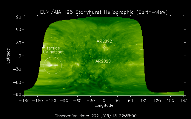
[spaceweather.com]
If so, dark cores will rotate into view over the sun’s southeastern limb this weekend.
Could this be the one?
Stay tuned for updates.
Coronal Mass Ejections and their Increasing Threat Moving Forward - Electroverse
Coronal Mass Ejections and their Increasing Threat Moving Forward: a CME is a certainty, and with our waining magnetosphere the threat is ever increasing.
The COLD TIMES are returning, the mid-latitudes are REFREEZING, in line with the great conjunction, historically low solar activity, cloud-nucleating Cosmic Rays, and a meridional jet stream flow (among other forcings).
Both NOAA and NASA appear to agree, if you read between the lines, with NOAA saying we’re entering a ‘full-blown’ Grand Solar Minimum in the late-2020s, and NASA seeing this upcoming solar cycle (25) as “the weakest of the past 200 years”, with the agency correlating previous solar shutdowns to prolonged periods of global cooling here.
Furthermore, we can’t ignore the slew of new scientific papers stating the immense impact The Beaufort Gyre could have on the Gulf Stream, and therefore the climate overall.
Prepare accordingly— learn the facts, relocate if need be, and grow your own.
TxGal
Day by day
Tropical storm Andres forms in Pacific, earliest on record; another busy Atlantic hurricane season expected -- Earth Changes -- Sott.net
Tropical storm Andres forms in Pacific, earliest on record; another busy Atlantic hurricane season expected
Tyler Durden
ZeroHedge
Mon, 10 May 2021 19:38 UTC

© National Hurricane Center
Andres is the earliest eastern tropical Pacific (to 140°W) named storm formation on record
Tropical Storm Andres is the earliest named storm to develop in the eastern Pacific Ocean, surpassing Adrian in 2017. Andres became a tropical storm on Sunday, according to the National Weather Service.
Andres formed off the southwest coast of Mexico Sunday, had sustained winds of 40 mph and moved out to sea at six mph.
"Increasing southwesterly to westerly shear and drier air to the west of the cyclone should prevent any significant additional strengthening," the National Hurricane Center said Sunday.
Meteorologist Phil Klotzbach from Colorado State University said, "Andres is the earliest calendar year eastern tropical Pacific (to 140°W) named storm formation on record, breaking the old record of May 10 set by Adrian in 2017."
View: https://twitter.com/philklotzbach/status/1391408279780220928
The official start of the eastern Pacific hurricane season is May 15. The Pacific is not the only ocean basin expected to observe increasing tropical activity this year. Another above-average Atlantic hurricane season is expected. The season starts on June 1.
Klotzbach expects there will be 17 named storms in the Atlantic - eight becoming hurricanes.
Refinitiv's commodity desk provides a more in-depth view of the 2021 hurricane season, only to say it will be the 6th consecutive season of above-normal tropical activity in the Atlantic:

Unlike last season, the 2021 outlook does not include a hyperactive season within the expected range of outcomes, though there is very little chance for below normal activity this season. Upside toward an active season does exist if key forecast drivers consolidate in that direction, and above normal tropical activity is anticipated based on all metrics except for major hurricanes this season. It should be noted that a "normal hurricane season" now represents higher levels of tropical activity in all aspects because of the climatology update that uses 1991-2020 as the baseline instead of 1981-2010. For example, if our 2021 outlook was issued based on the previous climatology, our forecast would call for an active season instead of a near normal one. Related to the climatology change (increased storm number), the Greek alphabet will no longer be used to extend the name list moving forward, replaced by a secondary name list if the initial one is exhausted. Details behind our 2021 outlook are outlined below:
Separate from overall Atlantic hurricane activity, impacts on commodities such as oil and shipping depend on storms reaching the Gulf of Mexico and/or making landfall in North America. The analog years used in the forecast and current SST anomalies both depict the U.S. East Coast as being at the greatest risk for higher impacts than usual based on warm ocean waters off the coastline. If the picture holds, any developing tropical cyclone that moves across the Western Atlantic approaching the U.S. will have ample energy to tap into and become a high-impact hurricane if other environmental conditions allow. There is also a consensus for slightly warmer than normal SSTs around the Leeward Islands of the Caribbean Sea, making that another area to watch for high-end impacts this season. Gulf of Mexico SSTs are by no means cold but are nowhere near the record warmth of last year.
2020 verification and summary
The 2020 Atlantic hurricane season finished with 30 named storms, 13 hurricanes, and 6 major hurricanes. Total tropical activity came in at 176% of normal, as measured by accumulated cyclone energy (ACE). This hyperactive season made 2020 the 5th consecutive active season in the Atlantic, demonstrating the highest degree of tropical Atlantic activity since 2017. Our 2020 Atlantic tropical seasonal outlook called for an active season with a risk toward hyperactive levels, which means that the hyperactive season observed was within our anticipated range of outcomes albeit on the top end of the range.

FIGURE 2: Annual Atlantic seasonal (June-November) tropical cyclone activity from 1982-2021, with the top analogs (2000, 2008, 2011, 2012, and 2018) highlighted in red (green) for active (inactive) seasons, and the 2021 forecast highlighted in purple.

© ESRL/NCEP
FIGURE 3: Global composite SST anomalies (°C) from the top August-October analogs based on the leading forecast indicators, with a yellow box outlining the Niño 3.4 region. SST anomalies exceeding 0.5°C are enclosed by dashed black contours. Analog years influencing the composite are as follows, with equal weightings: 2000, 2008, 2011, 2012, and 2018.
Hopefully the 2021 Atlantic Hurricane season is nothing like 2020...

The 2020 hurricane season was memorable
Tropical storm Andres forms in Pacific, earliest on record; another busy Atlantic hurricane season expected
Tyler Durden
ZeroHedge
Mon, 10 May 2021 19:38 UTC

© National Hurricane Center
Andres is the earliest eastern tropical Pacific (to 140°W) named storm formation on record
Tropical Storm Andres is the earliest named storm to develop in the eastern Pacific Ocean, surpassing Adrian in 2017. Andres became a tropical storm on Sunday, according to the National Weather Service.
Andres formed off the southwest coast of Mexico Sunday, had sustained winds of 40 mph and moved out to sea at six mph.
"Increasing southwesterly to westerly shear and drier air to the west of the cyclone should prevent any significant additional strengthening," the National Hurricane Center said Sunday.
Meteorologist Phil Klotzbach from Colorado State University said, "Andres is the earliest calendar year eastern tropical Pacific (to 140°W) named storm formation on record, breaking the old record of May 10 set by Adrian in 2017."
View: https://twitter.com/philklotzbach/status/1391408279780220928
The official start of the eastern Pacific hurricane season is May 15. The Pacific is not the only ocean basin expected to observe increasing tropical activity this year. Another above-average Atlantic hurricane season is expected. The season starts on June 1.
Klotzbach expects there will be 17 named storms in the Atlantic - eight becoming hurricanes.
Refinitiv's commodity desk provides a more in-depth view of the 2021 hurricane season, only to say it will be the 6th consecutive season of above-normal tropical activity in the Atlantic:
- The 2020 Atlantic hurricane season ended up being hyperactive, with significant impacts on oil operations in the Gulf of Mexico as well as devastation in Nicaragua
- 2021 is likely to fall into the "near normal" category in terms of tropical activity, though there is upside risk toward an active season
- Impacts from landfalling hurricanes could shift eastward this season toward the U.S. East Coast and the Leeward Islands based on Atlantic SSTs

Unlike last season, the 2021 outlook does not include a hyperactive season within the expected range of outcomes, though there is very little chance for below normal activity this season. Upside toward an active season does exist if key forecast drivers consolidate in that direction, and above normal tropical activity is anticipated based on all metrics except for major hurricanes this season. It should be noted that a "normal hurricane season" now represents higher levels of tropical activity in all aspects because of the climatology update that uses 1991-2020 as the baseline instead of 1981-2010. For example, if our 2021 outlook was issued based on the previous climatology, our forecast would call for an active season instead of a near normal one. Related to the climatology change (increased storm number), the Greek alphabet will no longer be used to extend the name list moving forward, replaced by a secondary name list if the initial one is exhausted. Details behind our 2021 outlook are outlined below:
- Forecast Indicators: At a two-month lead time from the start of the 2021 Atlantic hurricane season (begins 01 June), and a four-month lead on the beginning of the peak season where ~90% of the total activity occurs, the major ocean basins are aligned in support of a near to above normal season of tropical activity once again. Beginning with ENSO (El Niño Southern Oscillation), there is an 80% chance of neutral or La Niña conditions being in place by the August-October peak of hurricane season, with only a 20% chance of El Nio. La Niña is the most favorable state for active Atlantic seasons as it supports low vertical wind shear needed for tropical cyclone intensification/formation, so the strong likelihood of neutral or La Niña conditions in 2021 supports an active year while the slight El Niño chance caps the potential to some degree. The Atlantic Multi-decadal Oscillation (AMO) shows an 80% chance to be in its favorable warm SST phase for Atlantic tropical activity. The largest question pertains to the Indian Ocean Dipole (IOD), which has a connection to Atlantic activity in relation the occurrence of dry air that suppresses tropical cyclone formation. In 2021, there are questions about the state of the IOD by August-October, which supports a nearer to normal hurricane season.
- 2021 Hurricane Season Outlook: Based on the forecast indicators outlined, analog years were selected to help produce a forecast for 2021 Atlantic tropical cyclone activity. The most reliable variable forecasted is accumulated cyclone energy (ACE), which is widely viewed as the best measure of cyclone activity as compared to total named storm number, hurricane number, etc. The reason for this is that tropical cyclones vary wildly in duration/lifetime (anywhere from 1-10+ days), so similar numbers of storms in different years can still represent very different levels of activity. We also represent the forecast in terms of average/expected numbers of tropical storms, hurricanes, and major hurricanes, which is what is presented in the forecast summary of Figure 1. Our forecast for the June-November hurricane season is for activity to be at 107% of normal. The spread among the analogs was relatively narrow, with 20% of the years showing below normal activity while the other 80% showed above normal activity (see Figure 2). Due to the narrow range among analog years relative to the new normal level of activity, 100% of the analog years used in the forecast fell into the "near normal" range (within 25% of normal). This results in a high confidence outlook for near to above normal activity in 2021, with the direction of ENSO and the IOD key issues to watch in the direction that the season takes.
Separate from overall Atlantic hurricane activity, impacts on commodities such as oil and shipping depend on storms reaching the Gulf of Mexico and/or making landfall in North America. The analog years used in the forecast and current SST anomalies both depict the U.S. East Coast as being at the greatest risk for higher impacts than usual based on warm ocean waters off the coastline. If the picture holds, any developing tropical cyclone that moves across the Western Atlantic approaching the U.S. will have ample energy to tap into and become a high-impact hurricane if other environmental conditions allow. There is also a consensus for slightly warmer than normal SSTs around the Leeward Islands of the Caribbean Sea, making that another area to watch for high-end impacts this season. Gulf of Mexico SSTs are by no means cold but are nowhere near the record warmth of last year.
2020 verification and summary
The 2020 Atlantic hurricane season finished with 30 named storms, 13 hurricanes, and 6 major hurricanes. Total tropical activity came in at 176% of normal, as measured by accumulated cyclone energy (ACE). This hyperactive season made 2020 the 5th consecutive active season in the Atlantic, demonstrating the highest degree of tropical Atlantic activity since 2017. Our 2020 Atlantic tropical seasonal outlook called for an active season with a risk toward hyperactive levels, which means that the hyperactive season observed was within our anticipated range of outcomes albeit on the top end of the range.

FIGURE 2: Annual Atlantic seasonal (June-November) tropical cyclone activity from 1982-2021, with the top analogs (2000, 2008, 2011, 2012, and 2018) highlighted in red (green) for active (inactive) seasons, and the 2021 forecast highlighted in purple.
- Impacts: The 2020 Atlantic Hurricane season was a worst-case scenario in terms of impacts based on activity being strongly focused over the Gulf of Mexico and Central America (Figure 4). A flurry of storms made landfall in the Gulf of Mexico, with eastern Texans and Louisiana being the hardest-hit U.S. areas from two major hurricanes impacting the region. This activity caused major disruptions for oil operations in the Gulf of Mexico. Nicaragua also experienced landfalls by major hurricanes in close succession, which resulted in catastrophic damage to the coastal areas of the country. Meanwhile, the U.S. East Coast and the Caribbean Leeward Islands dodged major impacts in 2020 as generally quieter areas.

© ESRL/NCEP
FIGURE 3: Global composite SST anomalies (°C) from the top August-October analogs based on the leading forecast indicators, with a yellow box outlining the Niño 3.4 region. SST anomalies exceeding 0.5°C are enclosed by dashed black contours. Analog years influencing the composite are as follows, with equal weightings: 2000, 2008, 2011, 2012, and 2018.
Hopefully the 2021 Atlantic Hurricane season is nothing like 2020...

The 2020 hurricane season was memorable
northern watch
TB Fanatic
How is the major offshore Wind Farm in Mass. going to do in the Hurricane season?Tropical storm Andres forms in Pacific, earliest on record; another busy Atlantic hurricane season expected -- Earth Changes -- Sott.net
Tropical storm Andres forms in Pacific, earliest on record; another busy Atlantic hurricane season expected
Tyler Durden
ZeroHedge
Mon, 10 May 2021 19:38 UTC
© National Hurricane Center
Andres is the earliest eastern tropical Pacific (to 140°W) named storm formation on record
Tropical Storm Andres is the earliest named storm to develop in the eastern Pacific Ocean, surpassing Adrian in 2017. Andres became a tropical storm on Sunday, according to the National Weather Service.
Andres formed off the southwest coast of Mexico Sunday, had sustained winds of 40 mph and moved out to sea at six mph.
"Increasing southwesterly to westerly shear and drier air to the west of the cyclone should prevent any significant additional strengthening," the National Hurricane Center said Sunday.
Meteorologist Phil Klotzbach from Colorado State University said, "Andres is the earliest calendar year eastern tropical Pacific (to 140°W) named storm formation on record, breaking the old record of May 10 set by Adrian in 2017."
View: https://twitter.com/philklotzbach/status/1391408279780220928
The official start of the eastern Pacific hurricane season is May 15. The Pacific is not the only ocean basin expected to observe increasing tropical activity this year. Another above-average Atlantic hurricane season is expected. The season starts on June 1.
Klotzbach expects there will be 17 named storms in the Atlantic - eight becoming hurricanes.
Refinitiv's commodity desk provides a more in-depth view of the 2021 hurricane season, only to say it will be the 6th consecutive season of above-normal tropical activity in the Atlantic:
Our official forecast for the 2021 Atlantic Hurricane Season (described below) shows the likelihood for a near normal season, with tropical cyclone activity at ~107% of normal anticipated and a range of activity from 97-119% of normal. Our forecasted ACE, or accumulated cyclone energy, for 2021 is 131 (Figure 2). When the is translated into "plain English" and compared to normal, 17 named storms, 8 hurricanes, and 3 major hurricanes are expected from June-November (Figure 1). This compares to historical averages of 14 named storms, 7 hurricanes, and 3 major hurricanes, respectively.
- The 2020 Atlantic hurricane season ended up being hyperactive, with significant impacts on oil operations in the Gulf of Mexico as well as devastation in Nicaragua
- 2021 is likely to fall into the "near normal" category in terms of tropical activity, though there is upside risk toward an active season
- Impacts from landfalling hurricanes could shift eastward this season toward the U.S. East Coast and the Leeward Islands based on Atlantic SSTs
Unlike last season, the 2021 outlook does not include a hyperactive season within the expected range of outcomes, though there is very little chance for below normal activity this season. Upside toward an active season does exist if key forecast drivers consolidate in that direction, and above normal tropical activity is anticipated based on all metrics except for major hurricanes this season. It should be noted that a "normal hurricane season" now represents higher levels of tropical activity in all aspects because of the climatology update that uses 1991-2020 as the baseline instead of 1981-2010. For example, if our 2021 outlook was issued based on the previous climatology, our forecast would call for an active season instead of a near normal one. Related to the climatology change (increased storm number), the Greek alphabet will no longer be used to extend the name list moving forward, replaced by a secondary name list if the initial one is exhausted. Details behind our 2021 outlook are outlined below:
The 2021 SST (sea surface temperature) pattern suggests that landfalling impacts in the Atlantic could shift towards the US east coast
- Forecast Indicators: At a two-month lead time from the start of the 2021 Atlantic hurricane season (begins 01 June), and a four-month lead on the beginning of the peak season where ~90% of the total activity occurs, the major ocean basins are aligned in support of a near to above normal season of tropical activity once again. Beginning with ENSO (El Niño Southern Oscillation), there is an 80% chance of neutral or La Niña conditions being in place by the August-October peak of hurricane season, with only a 20% chance of El Nio. La Niña is the most favorable state for active Atlantic seasons as it supports low vertical wind shear needed for tropical cyclone intensification/formation, so the strong likelihood of neutral or La Niña conditions in 2021 supports an active year while the slight El Niño chance caps the potential to some degree. The Atlantic Multi-decadal Oscillation (AMO) shows an 80% chance to be in its favorable warm SST phase for Atlantic tropical activity. The largest question pertains to the Indian Ocean Dipole (IOD), which has a connection to Atlantic activity in relation the occurrence of dry air that suppresses tropical cyclone formation. In 2021, there are questions about the state of the IOD by August-October, which supports a nearer to normal hurricane season.
- 2021 Hurricane Season Outlook: Based on the forecast indicators outlined, analog years were selected to help produce a forecast for 2021 Atlantic tropical cyclone activity. The most reliable variable forecasted is accumulated cyclone energy (ACE), which is widely viewed as the best measure of cyclone activity as compared to total named storm number, hurricane number, etc. The reason for this is that tropical cyclones vary wildly in duration/lifetime (anywhere from 1-10+ days), so similar numbers of storms in different years can still represent very different levels of activity. We also represent the forecast in terms of average/expected numbers of tropical storms, hurricanes, and major hurricanes, which is what is presented in the forecast summary of Figure 1. Our forecast for the June-November hurricane season is for activity to be at 107% of normal. The spread among the analogs was relatively narrow, with 20% of the years showing below normal activity while the other 80% showed above normal activity (see Figure 2). Due to the narrow range among analog years relative to the new normal level of activity, 100% of the analog years used in the forecast fell into the "near normal" range (within 25% of normal). This results in a high confidence outlook for near to above normal activity in 2021, with the direction of ENSO and the IOD key issues to watch in the direction that the season takes.
Separate from overall Atlantic hurricane activity, impacts on commodities such as oil and shipping depend on storms reaching the Gulf of Mexico and/or making landfall in North America. The analog years used in the forecast and current SST anomalies both depict the U.S. East Coast as being at the greatest risk for higher impacts than usual based on warm ocean waters off the coastline. If the picture holds, any developing tropical cyclone that moves across the Western Atlantic approaching the U.S. will have ample energy to tap into and become a high-impact hurricane if other environmental conditions allow. There is also a consensus for slightly warmer than normal SSTs around the Leeward Islands of the Caribbean Sea, making that another area to watch for high-end impacts this season. Gulf of Mexico SSTs are by no means cold but are nowhere near the record warmth of last year.
2020 verification and summary
The 2020 Atlantic hurricane season finished with 30 named storms, 13 hurricanes, and 6 major hurricanes. Total tropical activity came in at 176% of normal, as measured by accumulated cyclone energy (ACE). This hyperactive season made 2020 the 5th consecutive active season in the Atlantic, demonstrating the highest degree of tropical Atlantic activity since 2017. Our 2020 Atlantic tropical seasonal outlook called for an active season with a risk toward hyperactive levels, which means that the hyperactive season observed was within our anticipated range of outcomes albeit on the top end of the range.
FIGURE 2: Annual Atlantic seasonal (June-November) tropical cyclone activity from 1982-2021, with the top analogs (2000, 2008, 2011, 2012, and 2018) highlighted in red (green) for active (inactive) seasons, and the 2021 forecast highlighted in purple.
- Impacts: The 2020 Atlantic Hurricane season was a worst-case scenario in terms of impacts based on activity being strongly focused over the Gulf of Mexico and Central America (Figure 4). A flurry of storms made landfall in the Gulf of Mexico, with eastern Texans and Louisiana being the hardest-hit U.S. areas from two major hurricanes impacting the region. This activity caused major disruptions for oil operations in the Gulf of Mexico. Nicaragua also experienced landfalls by major hurricanes in close succession, which resulted in catastrophic damage to the coastal areas of the country. Meanwhile, the U.S. East Coast and the Caribbean Leeward Islands dodged major impacts in 2020 as generally quieter areas.
© ESRL/NCEP
FIGURE 3: Global composite SST anomalies (°C) from the top August-October analogs based on the leading forecast indicators, with a yellow box outlining the Niño 3.4 region. SST anomalies exceeding 0.5°C are enclosed by dashed black contours. Analog years influencing the composite are as follows, with equal weightings: 2000, 2008, 2011, 2012, and 2018.
Hopefully the 2021 Atlantic Hurricane season is nothing like 2020...
The 2020 hurricane season was memorable
An offshore wind project off Massachusetts is planned that would create 800 megawatts of electricity, enough to power 400,000 homes, and was approved by the federal government. The Vineyard Wind project, south of Martha's Vineyard near Cape Cod, would be the first utility-scale wind power development in federal waters.
So 400,000 homes will lose power, if the wind farm is blown away.
Last edited: