Solar Grand Solar Minimum part deux

TxGal

Day by day
The Sun to "Super-Flare" during the Summer of 2023? - Electroverse

solar-storm-e1619609616896.jpeg

Articles
THE SUN TO “SUPER-FLARE” DURING THE SUMMER OF 2023?
APRIL 28, 2021 CAP ALLON

While the Grand Solar Minimum will cause enough headaches and struggles to keep the human race occupied, there is an even more destructive threat looming: the shifting of Earth’s magnetic poles and the resulting depletion of our planet’s magnetic field (our protective shield against space weather).

One of the top scientists on the subject, David Mauriello of the Oppenheimer Ranch Project, has gone so far as to call the intensifying magnetic reversal his biggest worry: “It is my firm opinion that the magnetic reversal is more severe than the Grand Solar Minimum could ever be,” says Mauriello, because new research suggests that the combined effects of 1) a waning magnetosphere (a side-effect of the magnetic reversals/excursions, which can drop Earth’s magnetic field strength to below 10 percent of its maximum), coupled with 2) a powerful plasma discharge from the Sun could be due in as little as 2 years.

Citing a new study, “Discovery of an Extremely Short Duration Flare from Proxima Centauri Using Millimeter through Far-ultraviolet Observations,” one of the largest flares ever recorded in our galaxy –100 times more powerful than those emitted by the Sun– recently left Proxima Centauri, our star’s nearest neighbor.


An artist’s illustration of the Proxima Centauri planetary system. Portrayed on the right is the newly discovered exoplanet candidate Proxima c, which orbits the red-dwarf host star once every 5.2 Earth years. The system also includes the smaller Proxima b, on the left, a confirmed world that was discovered in 2016. (Image credit: Lorenzo Santinelli)

Proxima Centauri is a red dwarf –the smallest, dimmest and most common type of main sequence stars in the galaxy– located approximately 4.25 light-years from Earth — Mauriello considers this distance one of two key factors when calculating the impact of a newly discovered threat, with the other being the dating of the mega flare.

In the recently published study, researchers used nine ground and orbital telescopes –including the Hubble Space Telescope, the Atacama Large Millimeter/submillimeter Array and NASA’s Transiting Exoplanet Survey Satellite– to closely monitor Proxima Centauri for a total of 40 hours over several months in 2019. On May 1, 2019, the team captured the super flare, which shone for just 7 seconds and was mainly visible in the ultraviolet spectrum.

Even at just 7 seconds, the outburst would have been the equivalent of an X-200+ escaping the Sun. And note, the highest-rated flaring ever recorded was the X-45 registered back in 2003 (needless to say, the flare was not Earth-facing), while the infamous Carrington Event is also generally considered to have been around an X-45.

Solar flares are tremendous explosions in the atmosphere of the Sun. They are capable of releasing as much energy as a billion+ megatons of TNT. The result of the sudden release of magnetic energy, in just a few seconds flares can accelerate solar particles to incredibly high velocities, and heat solar material to tens of millions of degrees. And while these periodic outbursts of energy posed little to no threat to the civilizations of the past, even just a moderate flaring (a low X-flare) would cause the instant collapse of our modern tech-driven society.

So, given the two key factors pertaining to Proxima Centauri’s mega-flaring —May, 2019 and 4.25 light-years— it is Mauriello’s supposition that, if recent advances in the understanding of the galactic current sheet and its mimicking of the solar current sheet hold true, then the cosmic “wave” that hit Proxima Centauri –causing it to super-flare– could now be racing towards our own solar system, meaning it could only be a matter of time before our Sun flares in a similar way — you can think of it as a surge of electricity running through a cable, in this case through the galactic Birkeland current that connects every astronomical object. Doing the math –with the admittedly limited factors that are known– that time can be easily calculated: May 2019 (the date of Proxima’s flaring) + 4.25 years (the distance in light-years that the galactic current wave has to travel before it reaches our solar system) sees our Sun mega-flaring during the summer of 2023 (near the solar maximum of Cycle 25–now due in 2024, according to NOAA). Further supporting Mauriello’s supposition, and suggesting the wave is indeed headed our way is the fact that Barnard’s Star –at 5.978 light years away– also recently super-flared, before Proxima Centauri, and at the expected interval.


The flare wouldn’t even need to be Earth-facing, as such an outburst would likely cause a “halo effect.”

This would be the end of the grid, and game-over for life as we currently know it.

In addition, the ongoing waning of the magnetosphere would mean the Sun wouldn’t even need to outburst all that much — even a low-to-moderate X-flare would be enough to take out 90+ percent of the global population via the failure of our “systems”–namely food delivery infrastructures.

Also worth considering, this inbound galactic wave could-well be the trigger that flips Earth’s magnetic field into a full reversal.

Time will tell, of course, but we potentially don’t have much of it.

“You need to be ready (prepared) by the August of 2023,” concludes Mauriello.

Grow your own.

Boom.

David Mauriello currently works at the Climate Science Center in Pagosa Springs Colorado — popularly know as the Oppenheimer Ranch Project. Their current project is located in the south San Juan’s in southern Colorado. ‘Oppenheimer Ranch Project’ is dedicated to uncovering the truth related to paleoclimatological cycles driven externally as opposed to locally (man made), reads Mauriello’s Research Gate profile.

TODAY’S OTHER ARTICLES


TxGal

Day by day
Historic Spring Freeze Impacts EU and US Grain Crops - Electroverse

winter-wheat-cold-e1619682053111.jpg

Crop Loss Extreme Weather GSM
HISTORIC SPRING FREEZE IMPACTS EU AND US GRAIN CROPS
APRIL 29, 2021 CAP ALLON

The intensifying Grand Solar Minimum is causing concern for new-crop grains supply, and is fueling the current rally. Across the global grain markets, sizable gains have been registered, with Chicago maize prices rising 18 percent over the past week, and UK feed wheat futures gaining 17 percent in the last 12 days.

EUROPE
On Monday, the European Commission released its latest EU crop monitoring (MARS) report, detailing conditions to April 21. It reveals that the recent and long-lasting out-of-season freeze has delayed development of winter crops across the majority of the continent, while also delaying the sowing and emergence of spring drilled crops.

As a result, further cuts have been made by the Commission to its forecast yields.

The outlook doesn’t look good, with additional anomalously-cold weather expected in May:


Those pinks and purples in the above link represent temperature departures some 20C below the seasonal norm, and the harshest cold is forecast for the Ukraine, “the breadbasket of Europe”. It is little wonder Russia is so hellbent on reclaiming it: the Ukraine is one of the world’s top wheat exporters — its rich dark soils produced 28.4 million metric tonnes of the grain in 2019, putting it 7th on the list of global producers.

France is 5th on that list, narrowly behind the U.S., having produced 40.4 million metric tonnes of wheat in 2019. According to the EU’s MARS report, this year’s big freeze has actually hit France the hardest — and looking ahead, via the latest GFS run (shown below), French growers can expect more of the same as the calendar flips to May:


GFS 2m Temp Anomalies (C) April 29 to May 3 [tropicaltidbits.com].

UNITED STATES
The USDA also released their latest crop condition report this week.

To date, 17 percent of maize had been planted, and while this is up on the week before, it is 7 percentage points (pp) behind last year and 3pp behind the 5-year average. Iowa, Missouri, and Illinois are states identified as being severely behind the average planting progress (collectively, these states represent 36.2 percent of the U.S. maize crop).

For winter wheat, crop conditions had fallen week-on-week: the percentage of crops rated ‘good’ or ‘excellent’ plummeted to 49 percent — this is a fall of 4 pp week-on-week, and 5pp down on the same point last year.

The largest reductions were seen in Ohio, Texas, Washington, Montana, and Oklahoma (collectively 32 percent of U..S winter wheat production)–some of the worst hit regions during the latest freeze events.

And as in Europe, the near-future looks decidedly chilly.

After two days of warmth at the start of the May, an Arctic air mass looks set to descend May 3 with a second, and more powerful front, due around May 8/9 bringing with it the threat of rare May frosts:


GFS 2m Temp Anomalies (C) May 3 to May 11 [tropicaltidbits.com].

The COLD TIMES are returning, the mid-latitudes are REFREEZING in line with the great conjunction, historically low solar activity, cloud-nucleating Cosmic Rays, and a meridional jet stream flow (among other forcings).

Both NOAA and NASA appear to agree, if you read between the lines, with NOAA saying we’re entering a ‘full-blown’ Grand Solar Minimum in the late-2020s, and NASA seeing this upcoming solar cycle (25) as “the weakest of the past 200 years”, with the agency correlating previous solar shutdowns to prolonged periods of global cooling here.

Furthermore, we can’t ignore the slew of new scientific papers stating the immense impact The Beaufort Gyre could have on the Gulf Stream, and therefore the climate overall.


Prepare accordinglylearn the facts, relocate if need be, and grow your own.
 

TxGal

Day by day
April 2021 is on track to be the frostiest in Britain for 60 YEARS -- Earth Changes -- Sott.net

April 2021 is on track to be the frostiest in Britain for 60 YEARS

Colin Fernandez
Daily Mail
Wed, 28 Apr 2021 01:37 UTC

UK April snow
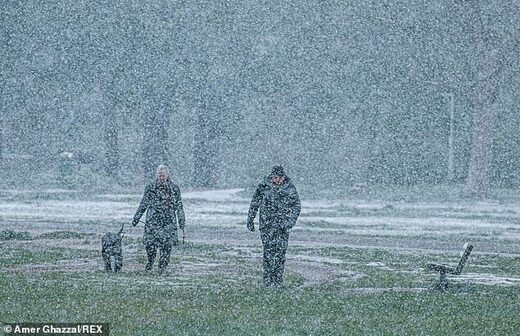
People walking their dog are caught in a heavy snow shower on Wimbledon Common on a cold morning with freezing temperatures on April 12

For gardeners whose flowers have been suffering from the cold, the news will come as little surprise.

This April has been Britain's frostiest in at least 60 years.

And experts warn it will cause severe damage to the harvest of plums, cherries and other soft fruit.

There have been 13 days of air frost in the past month, making it the frostiest April since records began in 1960, provisional Met Office data shows. The previous record holder was April 1970, with 11.

Despite the cold nights, the sunny weather means this month is also on course to be among the driest on record. So far there has been only 7 per cent of the average rainfall for the time of year. Mark McCarthy, of the National Climate Information Centre, said: 'We've been seeing a high frequency of frosts overnight throughout April thanks largely to persistent clear skies.'

But the conditions have caused havoc for many farmers and growers. Guy Barter of the Royal Horticultural Society said: 'Considerable damage has been experienced in many gardens with flowers such as camellia and magnolias being scorched, and cherry, plum and pear blossom injured so that the fruit crop will be reduced.'

Across the four nations, England has reported 12 days of air frost and Wales 11 days.

Scotland has reported 16 days, making it the frostiest April since records began in 1960.

Northern Ireland has currently seen eight days of frost, not yet exceeding its current record of 11 days set in April 1983.

It comes after several days of clear skies and sunshine across the UK, with double-digit daytime temperatures felt across large parts of the country.

The peak daytime temperature was felt last week in Porthmadog, Wales, where the mercury reached a maximum of 20.8C on Friday.

But clear skies mean that chillier nights and more frosts are expected to continue as the month comes to a close.

Annie Shuttleworth, meteorologist at the Met Office, said: 'We've seen high pressure dominating for the last few weeks which is why we've had the drier weather and less cloud.

'Clearer skies mean temperatures can cool off more readily overnight when there's no sun but in the day clearer skies can act to warm up the daytime temperatures.'

Average overnight temperatures have been hovering around freezing at 0.4C (32.7F), which is three degrees lower than the UK average for April at 3.4C (38.1F).

The maximum daytime temperature has also been slightly lower than average at 11.4C (52.3F), compared with 12C (53.6F) which is normal for April.

Ms Shuttleworth said that sunny spells would still feature in the coming days, but parts of the country would also see showers, and overnight temperatures would stay low.

The weekend weather was set to maintain the trend of what has been one of the driest Aprils on record, with the UK seeing less than a fifth of the average rainfall for the month so far.

Up to April 22, there had been an average of 12.8mm of rain across the UK, much lower than the April average of 72.53mm, according to Met Office figures.

A typical April in the UK would have had 70% of its rainfall by now, but it instead has just had 18%.

But Ms Shuttleworth said rain in the coming days could drive up averages.

'You could get some rain over the next couple of days that will bring the totals up,' she said.

'It has been a very dry April, with quite a few areas of the UK seeing quite a small margin of their average April rainfall.

'Some counties may see their lowest April rainfall but it won't be a UK-wide thing.'


Comment: Earlier this month France declared a national emergency after one-third of its wine production was lost to rare spring frosts.

View: https://youtu.be/onL31dRkdSk
Run time is 2:43

Meanwhile in the United States, Midwest and Eastern vineyards were hit by historic snow and freeze events.
 

TxGal

Day by day
Modern Survival Blog did a posting today on the Grand Solar Minimum:

Preparing For The Grand Solar Minimum (modernsurvivalblog.com)

https://modernsurvivalblog.com/natural-threats/
Preparing For The Grand Solar Minimum
04/28/2021
25 Comments

Will anyone recognize that a Grand Solar Minimum is apparently coming? And what are they (or you) going to do about it? How much of the food supply might be affected and how to prepare for it?

by Anony Mee

We engage in a preparedness lifestyle just in case misfortune befalls us. We often discuss what sorts of events those might be – loss of a job, medical emergencies, wars of various sorts, and how to prepare. Ken does a survey generally every year on what we’re all prepping for. It’s always interesting to see the results and comments on that article.

This past month I’ve written two articles for American Thinker on the Modern Grand Solar Minimum and, in the process, have managed to scare myself. (The Coming Modern Grand Solar Minimum)

My grandparents and parents lived through the Great Depression and the Dust Bowl. Mom’s family were wheat farmers. Dad’s folks were just plain dirt poor. They all suffered. Contemplating several years of low harvests, on a global scale, with perhaps more years of lingering bad weather, is still hard for me to wrap my head around.

Grand Solar Minimum – Once-In-Every-400-Years Event

No matter what else might happen in our lives, our families, our neighborhoods, or our country, our world is facing predictable dark cold years, estimated to begin in 2028 and continue at least through 2032. The low point of a Grand Solar Minimum is a once-in-every-400-years event.

I’m convinced that all the “noise” from the pandemic – the stupid shutdowns, the shortages due to pandemic-related issues, etc. – has masked the beginning of the Grand Solar Minimum. 2019 and 2020 saw failed or limited harvests over much of the globe, mostly due to weather. We’ll see if this year is any better. Hope it will be, but the lack of sunspot activity is grim, and it’s early in the minimum cycle for it to be so low.

The Year Without A Summer

maunder-minimum-chart.jpg

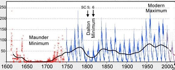
Chart: Years of Maunder Minimum & Dalton Minimum

1816 was the year without a summer. It was the trough of the Dalton Minimum. It was not even a Grand Solar Minimum (see the chart above).

The Dalton Minimum was also impacted by the 1815 massive eruption of Mt. Tambora in Indonesia. Violent eruptions tend to coincide with solar minimums.

In September 1816 Thomas Jefferson wrote to a friend, “We have had the most extraordinary year of drought & cold ever known in the history of America. . . . The crop of corn thro’ the Atlantic states will probably be less than ⅓ of an ordinary one, that of tobo still less, and of mean quality. The crop of wheat was midling in quantity, but excellent in quality. But every species of bread grain taken together will not be sufficient for the subsistence of the inhabitants.”

Grand Solar Minimum’s are marked by famine and societal upheaval.

Hopefully, we have several ‘not too bad years’ to get our affairs in order.
Here are some questions we might ask ourselves as we plan for this inevitable future:

How much food do we need to set aside for hard times to come because of the Grand Solar Minimum?

A pamphlet published some time ago by LDS members recommended these amounts for one person for one year of dry (dried, dehydrated, or freeze-dried) food:

Grains – 400 lbs, Beans & Legumes – 90 lbs, Milk & Dairy – 75 lbs, Meat – 20 lbs, Sugars – 60 lbs, Fruit & Vegetables – 90 lbs, and (not dried) Fats = 20 lbs. A full explanation of how this breaks down is here: Long Term Storage Food For 1 Year – How Much Food Is That? (modernsurvivalblog.com).

If we think that harvests will be 50% of normal, do we just cut these numbers in half? No. Long-season crops like grains, citrus fruits, and some vegetables may see their harvests more impacted than short-season fruits and vegetables.
Countries To Restrict Exports?

Countries may choose to restrict exports in order to have more for their own people which could impact chocolate, sugar, vanilla, spices, and out of season fresh items.

Federal Restrictions?

Given what we’ve experienced this past year with the pandemic, do we think that the federal government might restrict food availability to ensure “essential workers”, like the military, are fed first?
Do we think state and local governments might restrict access to food – grocery stores, restaurants, and farmers’ markets?
What About Food Programs?

How will the USDA feeding programs for seniors, breakfasts and lunches for school children, and farm-to-family programs be impacted?

If vendors limit the number of items someone can buy, will donations to local food banks and charitable feeding programs dry up?

Impacts To Food Access?

Access to food, from many sources, could be impacted. Will it, and if so to what extent – who knows?

Will Anyone Recognize And Do Something About It?

Are we in a position to increase our own gardening and preservation efforts?
If not, ask for help now rather than later.

This is our Genesis 41 (Joseph and Pharaoh’s dream of seven fat cows) moment. It will be a huge effort to ensure we and our loved ones make it through.

Hopefully, the government will heed the scientists’ warnings and begin to stockpile harvests to ensure the maximum number of people make it through. If it doesn’t, a great reset of another sort may also be upon us.
What do you think is the best way to proceed?

[ Ken adds:

NOAA is predicting a ‘full-blown’ Grand Solar Minimum (GSM)

GSM’s have the potential to hold sunspots at ZERO for multiple decades. The most famous example is the Maunder Minimum (1645-1715). It brought plummeting temperatures, crop loss, famine, and the deaths of hundreds of millions of people ACROSS the planet.

The Maunder Minimum was the most recent occurrence of what are known as grand solar minima. Periods of very low solar activity, that recur every 350 to 400 years. So we’re due for another minimum.

When is the next Grand Solar Minimum? A study published in the journal ‘Temperature‘, Prof. Valentina Zharkova demonstrates that the Sun has entered into the modern Grand Solar Minimum (2020 – 2053).

Note: comments follow the article at the link
 

TxGal

Day by day
Unprecedented Cold Invades Europe: "Eyelid Freezing Night Breaks Records" - Electroverse

cold-europe-april-29-e1619688284628.jpg

Extreme Weather GSM
UNPRECEDENTED COLD INVADES EUROPE: “EYELID FREEZING NIGHT BREAKS RECORDS”
APRIL 29, 2021 CAP ALLON
This year’s punishing winter has shown few signs of abating, even as May fast-approaches.

Across the European continent, the majority of nations are suffering their coldest April’s in decades–in around 100 years in Germany and the UK. This climatic reality (aka cooling) is in response to the historically low solar activity we’re been experiencing, as a decrease in output from the Sun weakens Earth’s jet streams and increases their tenancy to flow in more of a weak and wavy manor — this “meridional” flow, as it’s known, increases the prevalence of Arctic outbreaks and “blocking” phenomenons.

The year 2021 is also further ‘uncorrelating’ the link between global temperatures and rising CO2 emissions. For decades, the agenda-driving doomsayers have decreed that our planet’s average temp will rise on an endless march upward unless crippling economic and social reforms were immediately implemented (recently renamed “the Great Reset”) — well, does this (chart linked below) look like catastrophic global warming to you?


According to the 15 NASA/NOAA AMSU satellites –that measure every square inch of the lower troposphere (where us humans reside)– Earth has COOLED by a model-debunking 0.6 deg. C during the past 12 months.

And while we’re on the topic of failed climate modelling, linked below is the top-cited ERSST-v5 observational data, which reveals that Earth’s oceans haven’t warmed anywhere near as much as the prophecies (emphasis on the feces) threatened they would:


UNPRECEDENTED COLD INVADES EUROPE
Record freezes have been suffered across Europe this week.

In Germany, Czech Republic and Poland, temperatures have plunged to -6C (21.2F), and beyond, even at low elevations — readings that are “really rare for the end of April,” according to @extremetemps on Twitter:

View: https://twitter.com/extremetemps/status/1387001436685352961


While in Denmark, you have to go all the way back to 1981 to find a spring day as cold as last nights this late in the season, reports cphpost.dk, who have called the intensity of the cold “eyelid freezing.”

On the morning of April 27, the vast majority of Danes awoke to freezing temperatures.

Thermometers plunged to as low as -6.2C (20.8F) near Horsens, located in central Jutland, nearing the all-time late-April record low of -6.9C set in Nørre Sørig (North Jutland) back on April 29, 1981.

In addition, April as a whole is also on course to be Denmark’s coldest for at least 35 years (with more freezing nights on the way). And furthermore, the country hasn’t suffered three consecutive spring mornings this cold (below -5 deg. C) since 7-9 May, 1957.

In nearby Finland, temperatures are expected to remain colder than average in into the weekend, meaning May Day celebrations threaten to be an historically chilly affair, reports yle.fi.

“Cool air has been flowing into most of Finland in recent days, and the air continues to flow in from the north. No significant rise in temperature is expected by May Day, which means that the chilly spring weather continues,” said Yle meteorologist Matti Huutonen.

“We are experiencing colder-than-average weather,” confirmed Huutonen: at night, temperatures are forecast to dip below freezing throughout the entire country, and even as we head into May, “There is no indication that we are headed for more summery weather. The winds continue to flow from the same (northerly) direction,” said Huutonen who recommends finding warmth in the sauna.

And finally, the landlocked nation of Belgium is also suffering its coldest April in at least 35 years.

According to observations compiled by the country’s Royal Meteorological Institute (RMI) on Wednesday, and as originally reported by brusselstimes.com, “the average temperature in April has not been as low as this year since 1986” (solar minimum of cycle 21).

With an average temperature of 7.3C (45.1F), an average minimum of 2.5C (35.5F), and an average maximum of 11.9C (53.4F), April 2021 is coming out well-below the climatological norm, according to the RMI, with yet more cold on the way (see below link). Tellingly, the RMI has said the cold weather is due to the north-east wind that dominated, whereas in April the wind usually comes from the north-east (east) or south-west (west) — one further example of the prevalence of a “meridional” jet stream flow versus a usual “zonal” one.


As reported by Reuters, electricity prices this week traded higher on wholesale markets as unseasonably cold weather drove up demand across the European continent. The cold is having a bigger bearing in nations like France as much of its domestic heating comes from electricity.

TODAY’S OTHER ARTICLE:


The COLD TIMES are returning, the mid-latitudes are REFREEZING in line with the great conjunction, historically low solar activity, cloud-nucleating Cosmic Rays, and a meridional jet stream flow (among other forcings).

Both NOAA and NASA appear to agree, if you read between the lines, with NOAA saying we’re entering a ‘full-blown’ Grand Solar Minimum in the late-2020s, and NASA seeing this upcoming solar cycle (25) as “the weakest of the past 200 years”, with the agency correlating previous solar shutdowns to prolonged periods of global cooling here.

Furthermore, we can’t ignore the slew of new scientific papers stating the immense impact The Beaufort Gyre could have on the Gulf Stream, and therefore the climate overall.


Prepare accordinglylearn the facts, relocate if need be, and grow your own.
 

TxGal

Day by day
South Africa braces for an Early-Season Cold-Shot, as Global Temperatures Take an Inconvenient Tumble - Electroverse

jra55_global_temp_anomaly_last7days.png

Extreme Weather GSM
SOUTH AFRICA BRACES FOR AN EARLY-SEASON COLD-SHOT, AS GLOBAL TEMPERATURES TAKE AN INCONVENIENT TUMBLE
APRIL 29, 2021 CAP ALLON

This coming weekend looks set to be another chilly one across the ‘Rainbow Nation’ as the South African Weather Service (SAWS) warns the country to “brace” for polar cold from Friday-onward.

The service’s latest cold warning comes less than a week after South Africans suffered below-average temps from Limpopo to Gauteng, from Free State to North West provinces — last weekend, reported daytime highs dipped into the low 20s (C) and beyond, highly unusual for the time of year.

View: https://twitter.com/tWeatherSA/status/1387462095340441607

Early-season snowfall is even forecast in the Drakensberg regions of Eastern Cape and KwaZulu-Natal from early Friday, flurries that are expected to continue throughout the weekend.

The recent forecast also comes after SAWS released its long-range winter weather outlook. According to the report, a “colder-than-average winter” is in store for Gauteng and eastern parts: “Maximum temperatures are expected to be below normal compared with recent years”, said SA meteorologist Vanetia Phakula.

View: https://twitter.com/SAWeatherServic/status/1387432389962575886

Across large portions of the Southern African continent anomalous cold looks set to intensify during the start of May, particularly in the nations of Botswana, Zimbabwe, Mozambique, Angola, Zambia, Tanzania, DRC, and, as detailed above, South Africa:

MAY 1:

GFS 2m Temp Anomalies (C) May 1 [tropicaltidbits.com].

MAY 2:

GFS 2m Temp Anomalies (C) May 2 [tropicaltidbits.com].

MAY 3:

GFS 2m Temp Anomalies (C) May 3 [tropicaltidbits.com].

The cold is also forecast to push further north, into The Rep. of Congo, Gabon, Cameroon, and even Nigeria, Chad and Sudan. And then if you continue to follow the cold “up” you soon hit Europe, which has been struggling with its own influx of record cold of late, due to persist:

MAY 3:

GFS 2m Temp Anomalies (C) May 3 [tropicaltidbits.com].

Polar cold is currently stretching the entire “length” of the planet: the Arctic is descending into Europe while Antarctica, simultaneously, is invading large portions of the southern hemisphere (including Australia).

This setup can’t be explained-away with your usual “spring/fall” fluctuations, this cold is proving unprecedented and also very persistent, as demonstrated by the below charts which detail the chill of 2021 (to date). The opening four months of the year are coming out at just 0.10C above the multidecadal average if you go by the JRA-55 (fig. 1), with the most recent datapoint (March) from the UAH (fig,2) plotting BELOW the 30-year average:


Fig.1: JRA55 Temp Anomalies for 2021 (to April 26) — [climatlas.com]


Fig.2: UAH Satellite-Based Global Temperature (through March) — [drroyspencer.com].

Real-world observations continue to make life tricky for the global heaters.

TODAY’S OTHER ARTICLES


Both NOAA and NASA appear to agree, if you read between the lines, with NOAA saying we’re entering a ‘full-blown’ Grand Solar Minimum in the late-2020s, and NASA seeing this upcoming solar cycle (25) as “the weakest of the past 200 years”, with the agency correlating previous solar shutdowns to prolonged periods of global cooling here.

Furthermore, we can’t ignore the slew of new scientific papers stating the immense impact The Beaufort Gyre could have on the Gulf Stream, and therefore the climate overall.


Prepare accordinglylearn the facts, relocate if need be, and grow your own.
 

jed turtle

a brother in the Lord
This thread is important not only in the continuous news of record breaking cold world-wide, but in keeping each of us motivated To prepare as much as we can for the shift in climate. It is easy to be distracted by almost anything else, but reading this thread everyday has kept my focus on the things I must do in order to have a hope of keeping my family fed out of my garden no matter the weather ahead. So, thank you texgal (and others) for keeping this going!
 

TxGal

Day by day
Saxony - Coldest April in 30 years - Ice Age Now

Saxony – Coldest April in 30 years
April 29, 2021 by Robert

27 April 2021 – With only a few days left, this April can no longer be saved: It will be the coldest of the last 30 years.
In Germany and Saxony, especially on Tuesday night, another real frost roared in from the east.

In Saxony, the temperature dropped to below minus five degrees (23F). Early Wednesday morning was similarly well below freezing.

In western Germany there were considerably more frost days than usual this April. Instead of the normal two, it amounted to ten, says Torsten Lehne, a meteorologist at the DWD in Leipzig.

Eastern Germany also saw two or three days more April frost than normal.

And according to reader Ric, it has been the coldest April in Switzerland in at least 20 years.

Meanwhile, the center of Russia was covered with snow

Not only snow, but abundant snow, with the restoration of the snow cover!

On the morning of April 27 in Kashira (in the south of the Moscow region) there was 17 cm of freshly fallen snow and in Plavsk (Tula region) – up to 20 cm!

Центральную Россию засыпало весенним снегом

Also record snow in the eastern Moscow region

April is very changeable in the middle of the road: that summer promises, will please you with unprecedented heat, then you will remember winter again.

In Pavlovsky Posad we can already speak of records. In less than a day, 25 mm of precipitation fell on the city in the form of rain, hail and snow, the most in 80 years. A snow cover with a height of 17 cm was formed. In the morning, the snow fell to 9 cm.

Soon there will be no more traces of the falling snow, but never before has snow cover returned in the second half of April.

And due to the wind it will feel like we are in early April, not the end.

Новости погоды

Sachsen-Wetter: So wird das Wochenende

Thanks to Argiris Diamantis in the Netherlands and Martin Siebert for these links
 

TxGal

Day by day
Adapt 2030 has a new podcast out:

Variants of Time in Slippage Between Ice Ages - YouTube

Variants of Time in Slippage Between Ice Ages
7,506 views • Apr 29, 2021

View: https://youtu.be/wFh-FLObnRE
Run time is 18:47

Synopsis provided:

A recent episode of Mini Ice Age Conversations Radio Program from (STUDIO A 10pm-Midnight) on Revolution Radio. Ransom Godwin from 420TVFreedomistFilms1776 YouTube Channel and David DuByne from ADAPT 2030 discuss how Artificial Intelligence may be harnessing the computing power of the human mind to connect to the source from the quantum realm to the physical third dimension.

• Co-existing with other different hominoids on Earth through history
• How long has the present human race been on this planet
• Jupiter Ascending and the farm planet Earth
• Most precocious commodity on Earth (THOUGHT)
• A fifth dimensional realm (THOUGHT & IMAGINATION)
• Can A.I project creativity into the human realm?
• A bridge from the quantum realm to the physical plane
 

TxGal

Day by day
Central Russia Experiences Record Spring Snow, as Crimea Suffers Exceptionally Cold April - Electroverse

April-28-Russia-snow-e1619768429884.jpg

Crop Loss Extreme Weather GSM
CENTRAL RUSSIA EXPERIENCES RECORD SPRING SNOW, AS CRIMEA SUFFERS EXCEPTIONALLY COLD APRIL
APRIL 30, 2021 CAP ALLON

After an historically cold and record-smashingly snowy winter, parts of Russia –namely Siberia– have finally been experiencing a little Spring warmth; or rather they were, before this week’s return of the Arctic.

“After the recent warm days, there was a breeze of cold,” is how hmn.ru puts it — and to paraphrase the rest, as the translation gets jumbled, the last week of April was not only cool in and around the Moscow region, but conditions were akin to those suffered in the depths of winter, with substantial snowfall totals to match.

Eastern regions reportedly saw the greatest snow cover, which lingered on the ground for some time, long enough for children to make snowmen and have snowball fights.


Heavy, out-of-season snow in the Tula regions, Russia (April 28).

In Kashira, a heavy blanket settled on the morning of April 28.

While Pavlovsky Posad received even more snow, “and we can already talk about records,” continues the hmn.ru article. In just a few hours, 17 cm (6.7 inches) of snow had accumulated in the city — the highest ever recorded in books dating back to 1941. As the morning hours progressed the snow subsided to 9 cm, and by late-afternoon there was barely a trace left; however, in the 80 years of records, “there has never been such a snow cover in the second half of April.”

View: https://twitter.com/ZdenekNejedly/status/1387326773524828162

Even higher totals still were reported by gismeteo.ru, including the 20+cm (7.9 inches) registered in Plavsk.

CRIMEA SUFFERING EXCEPTIONALLY COLD APRIL

Cold weather is prevailing in nearby Crimea, too.


During the entire month of April the temperature in Simferopol (locatable on the map above) has never exceeded 20C (68F) — an historic feat. And last year was “very similar,” reads another hmn.ru article, with thermometer readings more often below the climatic norm than above in 2020, too — yet another example of ‘the extension of winter’ predicted by times of low solar activity.

A real danger of frosts hung over the blossoming Crimea this week, and in central and northern regions of the peninsula, the mercury did indeed touch zero: in the village of Nizhnegorskoye, for example, thermometers sank to 0 degrees Celsius and a ground frost was noted.

This region of the world has been suffering serious anomalous cold of late. The Ukraine is Europe’s Breadbasket, and along with the rest of the continent, bone-chilling cold has prevailed for the past few months, causing serious delays to grain plantings, as well as issues to many other crops.


And as anecdotal evidence of Europe’s ongoing chill: I’m currently writing this in an unheated trailer (my temporary office) in Central Portugal, and at 07:30 AM my thermometers are reading 5.9C (42F) — that’s more than 6C below the seasonal minimum. ‘Global warming’ continues to be demonized by the IPCC, the MSM, and those hokey pop-scientists, yet heat has only-ever proved beneficial for life on our planet — it’s the cold that gets us.


The COLD TIMES are returning, the mid-latitudes are REFREEZING in line with the great conjunction, historically low solar activity, cloud-nucleating Cosmic Rays, and a meridional jet stream flow (among other forcings).

Both NOAA and NASA appear to agree, if you read between the lines, with NOAA saying we’re entering a ‘full-blown’ Grand Solar Minimum in the late-2020s, and NASA seeing this upcoming solar cycle (25) as “the weakest of the past 200 years”, with the agency correlating previous solar shutdowns to prolonged periods of global cooling here.

Furthermore, we can’t ignore the slew of new scientific papers stating the immense impact The Beaufort Gyre could have on the Gulf Stream, and therefore the climate overall.


Prepare accordinglylearn the facts, relocate if need be, and grow your own.
 

TxGal

Day by day
Unseasonal snowfall covers mountains in Gangwon Province, South Korea -- Earth Changes -- Sott.net

Unseasonal snowfall covers mountains in Gangwon Province, South Korea

Yonhap News Agency
Fri, 30 Apr 2021 10:01 UTC

Mount Seorak in the northeastern province of Gangwon is covered with snow on April 30, 2021, in this photo provided by Seoraksan National Park Office.

Unseasonal snowfall blanketed mountainous areas of Gangwon Province, east of Seoul, on Friday, the last day of April usually known in South Korea as a season of early summer-like warm weather.

Late-night rain turned into snow in the Gangwon mountains 1,300 meters above sea level early Friday morning, with 15 centimeters of snow recorded on and around the peak of Mount Seorak, about 200 kilometers east of Seoul, as of 9 a.m., according to national park officials there.

Similar amounts of snow also piled up on other renowned Gangwon mountains, such as Mount Balwang and Mount Odae, offering unseasonal winter scenery, they said.

View: https://youtu.be/RYdem-237o4

Run time is 0:34

Gangwon's non-mountainous areas were drenched in rain, with precipitation reaching 29 mm in the eastern coast city Gangneung, 28 mm in the northeastern border county Hwacheon, 23.7 mm in Hongcheon and 22.2 mm in Sokcho, according to the Korea Meteorological Administration (KMA).

In the central city Daejeon and surrounding South Chungcheong Province, meanwhile, strong winds caused about 100 cases of property damage overnight.

Strong winds blowing at the maximum instantaneous speed of over 20 mps caused destruction of outdoor signboards, building structures and street trees early Friday morning, but no casualties were reported.

Elsewhere in the country, the KMA forecast scattered rain and cloudy weather over the weekend, with daily highs ranging from 14 C to 22 C.
 

TxGal

Day by day
Fierce hail storms batter Texas, Oklahoma: 'Billion-dollar' damage likely from 'gargantuan' hail -- Earth Changes -- Sott.net

Fierce hail storms batter Texas, Oklahoma: 'Billion-dollar' damage likely from 'gargantuan' hail

Doyle Rice
USA Today
Thu, 29 Apr 2021 16:10 UTC

Storm damage to cars in Norman, Oklahoma
© CHRIS LANDSBERGER/THE OKLAHOMAN
Storm damage to cars in Norman, Okla., on April 29, 2021, after a hail storm hit the area the day before.

Residents in Texas and Oklahoma were recovering Thursday after hail as large as softballs battered portions of the states a day earlier, leaving behind shattered windows on cars and in homes.

In Oklahoma, at least one injury was reported when large hail hit Norman and surrounding areas Wednesday evening, officials said. A National Weather Service spotter reported hail in excess of 3 inches in diameter around 9 p.m. in the Norman area.

A wind gust of 69 mph was measured in the area at 9 p.m. as the storm pushed through.

In all there were 38 reports of severe hail across the two states, according to the Storm Prediction Center.

"Yesterday was certainly a billion-dollar hail loss day across the U.S.," Northern Illinois University meteorologist Victor Gensini said. "San Antonio and Fort Worth, Texas - along with Norman - were all impacted with large to significant hail. In addition, there was one gargantuan (4 inch) hail report near Hondo, Texas."

View: https://youtu.be/CQoLyDO4yFI
Run time is 1:30

View: https://youtu.be/aeH1bcNjW_8
Run time is 1:01

CNN senior meteorologist Dave Hennen said that it would be the second billion-dollar disaster this year in Texas, following the extreme Arctic outbreak back in February.

Hail makes up the highest number of insurance claims each year and can exceed $10 billion in losses annually, according to the Weather Channel.

The storms were part of a sprawling system that brought severe weather and heavy rain to much of the southern and central Plains. In addition to large hail, storms also produced damaging winds and a few possible tornadoes, CNN said.

View: https://twitter.com/Kyle_Thiem/status/1387583451377844225

View: https://twitter.com/vortexrfd/status/1387592658915315719

Contributing: The Oklahoman


Comment: Last year the world was hammered by a record 50 billion-dollar weather disasters.

It is becoming more apparent that erratic seasons, extreme weather patterns and natural disasters are increasing, which is not a consequence of "human-caused climate change" (formerly known as man-made 'global warming') as parroted relentlessly by the MSM, but part of a natural cycle.

See also:
 

TxGal

Day by day

TxGal

Day by day
Cosmic Ray Flux and Global Cooling: the implications are upon us - Electroverse

planets-sun-earth-galaxy-preview-e1619777445604.jpg

Articles GSM
COSMIC RAY FLUX AND GLOBAL COOLING: THE IMPLICATIONS ARE UPON US
APRIL 30, 2021 CAP ALLON

GALACTIC Cosmic Rays are a mixture of high-energy photons and sub-atomic particles accelerated toward Earth by supernova explosions and other violent events in the cosmos, while SOLAR Cosmic Rays are effectively the same, only their source is the Sun.

Spaceweather.com and the students of Earth to Sky Calculus have been launching cosmic ray balloons almost weekly since March 2015–before the pandemic threw a spanner in. The team’s published results reveal that atmospheric radiation reached record highs just as solar activity hit a new space age low — the correlation is clear for all to see, with additional proxy data revealing it has been the case for time-immemorial.

During solar minimums –the low point of the 11 year solar cycle– the Sun’s magnetic field weakens and the outward pressure of the solar wind decreases. This allows more cosmic rays (CRs) to penetrate the inner solar system, including our planet’s atmosphere:


Cosmic Rays correlating with Sunspots.

Radiation levels have been increasing almost non-stop since the Earth to Sky Calculus monitoring program began, with the latest flights in Dec, 2019 (fig.1) and early-2020 (fig.2) registering new all-time highs:


(Fig.1)


(Fig.2) — The newest data from Abisko, Sweden show the increase is not limited to the stratosphere. It is also happening at aviation altitudes with a 3-year increase of ~12% even below 40,000 ft.

If this is indeed a Grand Solar Minimum we’re headed into, cosmic rays should be trending off the charts — and that is exactly what we’re starting to see:


Researchers at the Sodankyla Geophysical Observatory have been monitoring cosmic rays since 1964.

When CRs hit Earth’s atmosphere, they produce a spray of secondary particles that rain down on Earth’s surface (visualized in the below image). Among these particles are neutrons, and detectors –such as those in Oulu– count these neutrons as a proxy for cosmic rays.


Schematic diagram of a cosmic ray air shower. This ‘secondary spray’ is also what the Earth to Sky Calculus balloons measure.

Below is another look at the correlation between CRs and the Sun.

The top panel demonstrates the natural waxing and waning of cosmic rays with the 11-year solar cycle: during Solar Maximum cosmic rays are weak; during Solar Minimum they are strong.


THE IMPLICATIONS
Cosmic rays are bad–and they’re going to get worse — that’s the conclusion of a 2020 study entitled “Galactic Cosmic Radiation in Interplanetary Space Through a Modern Secular Minimum.”

The type of radiation produced by cosmic rays is the same used in medical X-ray machines and airport security scanners. This radiation has increased by more than 20% in the stratosphere, according to spaceweather.com data.

Cosmic rays penetrate commercial jets, delivering whole-body dosages equal to one or more dental X-rays even on regular flights across the USA. Cosmic rays pose an even greater hazard to astronauts, as you would expect. They can also alter the electro-chemistry of Earth’s upper atmosphere, sparking lightning.

“During the next solar cycle, we could see cosmic ray dose rates increase by as much as 75%,” says lead author Fatemeh Rahmanifard of the University of New Hampshire’s Space Science Center. “This will limit the amount of time astronauts can work safely in interplanetary space.”

No amount of spacecraft shielding can stop the most energetic cosmic rays, leaving astronauts exposed whenever they leave the Earth-Moon system. Back in the 1990s, astronauts could travel through space for as much as 1000 days before they hit NASA safety limits on radiation exposure. Not anymore. According to the new research, cosmic rays will limit trips to as little as 290 days for 45-year old male astronauts, and 204 days for females (men and women have different limits because of unequal dangers to reproductive organs–my apologies to all those with an ‘overinflated sense of uniqueness’ that are offended by this gender stereotyping fact!).

However, far more crucial than limiting jollies into space –and fantasies of colonizing Mars– cosmic rays hitting Earth’s atmosphere have been found to seed clouds (Svensmark et al). Cloud cover plays the most important role in our planet’s short-term climate change: “Clouds are the Earth’s sunshade,” writes Dr. Roy Spencer, “and if cloud cover changes for any reason, you have global warming — or global cooling.” And while an overturning of ocean currents, a reduction in TSI, an increase in ice/snow albedo, or a VEI 6+ volcanic eruption are all capable of reducing Earth’s terrestrial temperature, all that is actually required is an uptick in CRs (check) leading to an increase in cloud cover (check).


To conclude, the upshot of the historically weak solar minimum of cycle 24 –-the Sun’s deepest of the past 100+ years (NASA)-– combined with the further waning that is forecast for cycles 25 and 26 (and beyond) will be a inescapable cooling of the planet — and we’re already seeing the start of this: according to the satellites, the global average temperature has just dropped BELOW the 30-year baseline.


Bundle up.

THE DAY’S OTHER ARTICLE:


The COLD TIMES are returning, the mid-latitudes are REFREEZING in line with the great conjunction, historically low solar activity, cloud-nucleating Cosmic Rays, and a meridional jet stream flow (among other forcings).

Both NOAA and NASA appear to agree, if you read between the lines, with NOAA saying we’re entering a ‘full-blown’ Grand Solar Minimum in the late-2020s, and NASA seeing this upcoming solar cycle (25) as “the weakest of the past 200 years”, with the agency correlating previous solar shutdowns to prolonged periods of global cooling here.

Furthermore, we can’t ignore the slew of new scientific papers stating the immense impact The Beaufort Gyre could have on the Gulf Stream, and therefore the climate overall.


Prepare accordinglylearn the facts, relocate if need be, and grow your own.
 

TxGal

Day by day
NASA and NOAA "adjust" Temperature Data: raw measurements show the U.S. has been COOLING since the 1930s - Electroverse

Measured-US-temp-data-2-e1619784709945.png

Articles
NASA AND NOAA “ADJUST” TEMPERATURE DATA: RAW MEASUREMENTS SHOW THE U.S. HAS BEEN COOLING SINCE THE 1930S
APRIL 30, 2021 CAP ALLON

Thanks to the excellent work being done by Tony Heller more and more government agency data fudging antics are being exposed.

The pair of charts in the below tweet offer a clear before and after snapshot of all U.S. historical climatology network stations–before and after NASA and NOAA carry out their inexcusable “adjustments.”

First, you have the official “reported” figures, which show a warming trend.

And second, is the actual “measured” data which reveals an unmistakable cooling trend.

Temperature trends from government agencies are propaganda, not science. They have nothing to do with reality and almost nothing to do with thermometer data. pic.twitter.com/GEF1WUA0G4
— Tony Heller (@Tony__Heller) April 30, 2021

Below is a blown-up view of U.S. thermometer data before NASA/NOAA got their grubby little paws on it.

What the chart reveals is that temperatures were actually warmer from 1920 to 1960 than they are today.

They were comfortably warmer, in fact, often by 2 or 3 degrees Fahrenheit.


The same trend is realized in the chart below, which shows the percent of days above 90F (32.2C) in the years between 1901-2019 again at all U.S. historical climatology network stations (also note that the chart runs through 2019, and so excludes the record cold influxes of the past year and a half):

Percentage-of-Days.png


The National Climate Assessment data further supports the trend, showing that summers were much hotter across the United States from around 1910-1960:


[Climate Science Special Report]

Additionally, recent sea surface temperature observations –even those controlled by the warm-mongers– clearly show that those catastrophic climate projections are proving some way off the reality:

68-models-vs-obs-1979-2021-oceans-Fig01.jpg

For more on that, click HERE.

If you haven’t yet cottoned on to the fact that governments routinely lie to their people then the above charts should offer you a window in. Global warming is hardly “global” if the united states –the fourth largest country on the planet– has been cooling since the end of the dust bowl. And I think it is also reasonable to assume that the U.S. is not alone in having a cooling trend since the mid-1930s, there is nothing geographically unique about the North American continent–and that notion would match well with observed solar output which has been after the increased activity between 1930 to 1960 has been gradually waning:


Data is easily manipulated, and massaged statistics have been used to prove points and enact policy for centuries. And today, it appears government agencies –played by the unseen puppet masters above them– have found a shiny and powerful new tool to ad to their fear and control arsenal: “the climate emergency.”

One final note on this topic:

‘Fire burn acreage’ was much higher from 1910-1960 than it is today, which isn’t surprising because heatwaves are normally associated with drought, points out Heller. There is a close correlation between heatwaves and burn acreage, as visualized in the below chart which overlaps the official heatwave data (red line) with that of the burn acreage (blue and green lines):


The powers-that-be want you to believe that forest fires are a direct result of rising temperatures, but as Heller has demonstrated: temperatures are not rising, and neither is the Fire burn acreage.

The actual data destroys “the climate emergency” narrative, and so the Biden administration has recently erased the pre-1983 fire data giving the lackluster reasoning that “it wasn’t official” (linked here). And after delving a little deeper, the real reason they deleted the pre-1983 data is because the year 1983 contained the lowest burn acreage on record, so by starting in 1983 they have been able to make it look like burn acreage is increasing.

In reality, there is zero-correlation between rising CO2 and burn acreage. Burn acreage in the U.S. is actually down 90 percent since CO2 was at pre-industrial levels — but the administration has recently deleted this document, too:


Don’t fall for the agenda-driving lies spouted by power-hungry politicians and cock-and-bull pop-scientists.

The truth is that the COLD TIMES are returning, that the mid-latitudes are REFREEZING in line with the great conjunction, historically low solar activity, cloud-nucleating Cosmic Rays, and a meridional jet stream flow (among other forcings).
Both NOAA and NASA actually appear to agree, if you read between the lines, with NOAA saying we’re entering a ‘full-blown’ Grand Solar Minimum in the late-2020s, and NASA seeing this upcoming solar cycle (25) as “the weakest of the past 200 years”, with the agency correlating previous solar shutdowns to prolonged periods of global cooling here.
Furthermore, we can’t ignore the slew of new scientific papers stating the immense impact The Beaufort Gyre could have on the Gulf Stream, and therefore the climate overall.


Prepare accordinglylearn the facts, relocate if need be, and grow your own.
 

TxGal

Day by day
MET Office downplaying April cold - Ice Age Now

MET Office downplaying April cold
April 30, 2021 by Robert

Coldest in 99 years, but MET Office tries to divert your attention by talking about ‘frostiest’ instead of ‘coldest.’

Frostiest April for at least 60 years in UK, reads the headline.

“April 2021 has provisionally been the frostiest in at least 60 years for the UK, topping the previous frostiest April in 1970, with records going back to 1960.”

“This is how the MET Office downplays the coldest April in England in 99 years (records about the CET Central England Temperature going back many hundreds of years),” says Argiris Diamantis in the Netherlands.

“They don’t talk about the coldest April in England, but about the frostiest April in the UK, records going back to 1960. This way they don’t have to go back further, because records of the FROSTIEST April in the UK do not go back further.”
“Many farmers and fruit growers suffered enormous losses.”


Frostiest April for at least 60 years in UK

In fact, it has been cold across Europe.

Cold April across Europe.

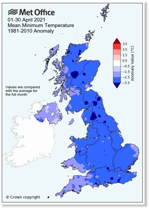
Temperature anomaly up to April 30, in relation to the climate norm 1981-2010

European-Cold-Anomaly.jpg

https://dobrapogoda24.pl/uploads/assets/8907/full_Zimny_kwiecień_2021.jpg

Coldest April in Germany in 40 years

According to the Polish website Dobra Pogoda 24, this April was the coldest in Germany for more than the last FORTY years (not 30). And for England the coldest April in almost 100 years.

April 30, 2021:

“Outrageously cold April in Europe

In Poland, the lowest temperature in 24 years, in Germany for over 40.

April 2021 is coming to an end and we want to forget about it quickly.

Scandalous low temperatures with frosts and snowfall affected not only Poland, but many other European countries.

Coldest April in Poland in 24 years

Preliminary summaries say about the coldest April in England since 1922, in Germany since 1980, and in Poland this year’s April is the coldest in 24 years, i.e. since 1997.

According to the data of the British Met Office, in the UK, an average of 13 days with frost (data until April 27)! The new record broke the previous one from 1972 by at least 2 days. Many farmers and fruit growers suffered enormous losses.

There were also significant losses in grapevine cultivation in France. The famous French wine may be less on the tables.

Germany is very disappointed in April, because the exceptionally warm end of March and the beginning of April filled us with optimism for the warm remaining days. But the descending jet stream far south quickly dropped the “chill bomb” with a prolonged advection of cold air flowing in from the north, including the Arctic.

April 2021 in Germany the coldest since 1980

2nd coldest in entire measurement history


The end of April 2021 brought 13 days of frost in Germany. In this respect, it was the 2nd coldest in the entire measurement history. More days with frost were recorded in Germany only in 1929. The average temperature this year in April was 6.1 degrees Celsius. It was -1.3 degrees lower than the average for the base period 1961-1990.

Across Europe, persistently low temperatures significantly delayed plant vegetation

April 2021 in Europe was a cold month from the British Isles, through France, the Benelux countries, Germany, Poland, parts of Norway to western Ukraine and the Balkans. Persistently low temperatures, including frosts, significantly delayed plant vegetation.

This year’s cold April delayed the arrival of the phenological spring. The pictures compare the vicinity of Barlinek from April 28. On the left from 2020, on the right from 2021.

https://dobrapogoda24.pl/uploads/assets/8908/full_Gdzie_wiosna_kwiecień_2021.jpg

Skandalicznie zimny kwiecień w Europie. W Polsce najniższa temperatura od 24 lat, w Niemczech od ponad 40 | DobraPogoda24.pl

Thanks to Argiris Diamantis for these links
 

TxGal

Day by day
Oppenheimer Ranch Project put out a short podcast on the Japanese earthquake:

Significant Magnitude 6.7 earthquake 45 km southeast of Ishinomaki, Japan - YouTube

Significant Magnitude 6.7 earthquake 45 km southeast of Ishinomaki, Japan
2,736 views • Premiered 8 hours ago

View: https://youtu.be/wjbwh1A0W5M
Run time is 3:17

Synopsis provided:

A 6.8 magnitude earthquake that also measured a strong 5 on the shindo (intensity) scale struck off Japan’s northeastern coast Saturday, no tsunami warning was issued https://bit.ly/3vAE1Dc
Significant Magnitude 6.7 earthquake 45 km southeast of Ishinomaki, Japan https://bit.ly/3uaQcpF
Tsunami Warning Center https://www.tsunami.gov/
Solar Wind
http://bit.ly/2zqv7wT
 

TxGal

Day by day
Parts of Southern Africa hit by Early-Season Snow, with heavy flurries now headed for SA - Electroverse


AfriSki-April-snow-1-e1619852039979.jpg

Extreme Weather GSM
PARTS OF SOUTHERN AFRICA HIT BY EARLY-SEASON SNOW, WITH HEAVY FLURRIES NOW HEADED FOR SA
MAY 1, 2021 CAP ALLON

As forecast, the enclaved Southern African nation of Lesotho was blanketed in “vast patches” of early-season snow on Friday, April 30, after the Mountain Kingdom experienced “something of a blizzard,” reads the thesouthafrican.com.

“AfriSki mountain resort in Lesotho welcomed its first major snowfall for the winter,” reports The South African in a recent YouTube video (linked here); however, this is a slightly inaccurate statement given that ‘winter’ in s. hemp doesn’t officially begin until June 21. Additionally, these ‘inches’ are also some of the earliest on record, having fallen in April — a fact not mentioned in the report.


Lesotho Snow, April 30 [Martin Schultz].


Lesotho Snow, April 30.

AfriSki resort, which is located at an elevation of 3,050m (10,000 ft), received a substantial bulk of the snowfall — at least 10cm (4 inches) has settled so far with plenty more in the forecast.

“Afriski Mountain Resort in Lesotho has welcomed its first major fall for the winter season. The snow started at 2:00 this morning and continued for a few hours covering the landscape around the resort with approximately 10cm.”
Peter Peyper, AfriSki Managing Director
A very warm good Morning from Lesotho pic.twitter.com/7qNNebhdy8
— Dodo (@Dodo_Nys) April 30, 2021
If you love snow then Lesotho is the the place to be right now
The mountains woke up to snow pic.twitter.com/6A4ynmJRmS
— StopGBV (@cecy_M_SL) April 30, 2021
The Mountain Kingdom is wrapped up in again#letsmakelesothofamous#visitlesotho pic.twitter.com/WUAHY4EmUR
— Lets Make Lesotho Famous (@FamousLets) April 30, 2021
The snow is now headed for South Africa — both the Eastern Cape and KZN are on track for substantial dustings as an Antarctic air mass gathers territory across the Rainbow Nation.

“Much more snowfall” is on its way to Drakensberg, according to local meteorologists.

The flakes are expected to make landfall overnight Friday, and continue into Saturday.

Stay tuned for updates.

RELATED ARTICLE:


RECENT ARTICLE EXPOSING DATA-TAMPERING:


The COLD TIMES are returning, the mid-latitudes are REFREEZING in line with the great conjunction, historically low solar activity, cloud-nucleating Cosmic Rays, and a meridional jet stream flow (among other forcings).

Both NOAA and NASA appear to agree, if you read between the lines, with NOAA saying we’re entering a ‘full-blown’ Grand Solar Minimum in the late-2020s, and NASA seeing this upcoming solar cycle (25) as “the weakest of the past 200 years”, with the agency correlating previous solar shutdowns to prolonged periods of global cooling here.

Furthermore, we can’t ignore the slew of new scientific papers stating the immense impact The Beaufort Gyre could have on the Gulf Stream, and therefore the climate overall.


Prepare accordinglylearn the facts, relocate if need be, and grow your own.
 

TxGal

Day by day
Brutal 2020/21 Northern Hemisphere Winter One for the Record Books - Ice Age Now

Brutal 2020/21 Northern Hemisphere Winter One for the Record Books
May 1, 2021 by Robert

Arctic-NASA.png

The northern hemisphere winter of 2020/21 was one for the record books and is dragging on into late April. Image credit (for illustration only) NASA

Reporting even more global cooling as measured by satellites and new harsh cold events, particularly in Western Europe that have severely harmed early crops.

Harsh cold events have also struck China, Russia, the Mediterranean, the Middle East, North America and Australia.


If you still think global warming is a problem, look at the sheer number of non-global warming events that have occurred in just the last few month. (Originally published by NoTricksZone.com on April 21, 2021.)

We published in 2002 that there was no catastrophic human-made global warming /climate change crisis, and green energy schemes were not green and produced little useful (dispatchable) energy.

Global warming is not a threat, but global cooling is dangerous. In 2002 we predicted that global cooling would start circa 2020, based on low solar activity, and that prediction is strongly supported by the evidence.

Our 2002 predictions are among the most accurate on the planet: If [as we believe] solar activity is the main driver of surface temperature rather than CO2, we should begin the next cooling period by 2020 to 2030.”

Updated global cooling prediction in 2013: “I suggest global cooling starts by 2020 or sooner. Bundle up.”

In this winter of 2020-2021, new record cold temperatures have been experienced all over the world, in January 2021 in Asia and in February 2021 in North America, Europe, the Mediterranean countries and the Middle East. I correctly predicted this cold winter in August 2020:

COLD WINTER APPEARS AS PREDICTED

Check out NIno34 temperatures, again down to Minus 0.6C – winter will be cold.

Nino34 SST anom’s hit minimums of minus1.4C-1.3C in Oct2020 and Nov2020 – so global coldest temperatures (+4 months) should be Feb2021 and Mar2021.

And that’s precisely what has happened: Global Lower Tropospheric Temperatures have declined 0.6C in 13 months, from an anomaly of +0.59C in February 2021 to only -0.01C in March 2021.

20+ WEATHER STATIONS ACROSS CHINA EQUAL/BREAK LOWEST-EVER TEMPERATURE RECORDS FOR MONTH OF DECEMBER January 2, 2021

ACCORDING TO THE SATELLITES, EARTH HAS COOLED RAPIDLY DURING THE PAST 2 MONTHS February 3, 2021

During the past two months, Earth has cooled, rapidly. The Version 6.0 Global Average Lower Tropospheric Temperature (LT) Anomaly for January, 2021 has come out at just +0.12 deg. C above the baseline, down 0.03 deg. C from the December, 2020 value of +0.15 deg. C.

What follows are dozens of links documenting the true harshness of the most recent winter.

41 RECORD LOWS SET IN ALBERTA, AS BRITAIN SUFFERS -22.9C (-9.2F) February 11, 2021
WORST SNOWFALL IN 50+ YEARS HITS MOSCOW,

MANITOBA SETS 20 NEW COLD RECORDS ON SATURDAY ALONE (IN BOOKS DATING BACK TO 1879),
AND CARS HAVE BEEN BURIED UNDER SNOWDRIFTS IN BRITAIN February 15, 2021


Record cold and snow has buffeted much of the Northern Hemisphere of late: from northern Asia, to the majority of Europe, to practically ALL of North America — the NH is suffering a truly historic winter of 2020/21 as the Grand Solar Minimum intensifies.

RECORD-SMASHING SNOW AND ICE STORMS LEAVE 5 MILLION AMERICANS WITHOUT POWER (AND COUNTING): “THE SITUATION IS CRITICAL” February 16, 2021

The historic Arctic front crippling Texas’s power system… energy prices soaring to record levels… at least 5 million people across the U.S. now plunged into darkness, unable to heat their homes.

LIBYA SEES SNOW FOR FIRST TIME IN 15 YEARS;

RARE FLAKES ALSO HIT EGYPT, SYRIA, LEBANON, PALESTINE, ISRAEL, JORDAN AND SAUDI ARABIA (AMONG OTHERS)

AS THE SUN HITS MILESTONE OF 2 SPOTLESS WEEKS February 18, 2021


Both NOAA and NASA appear to agree, if you read between the lines, with NOAA saying we’re entering a ‘full-blown’ Grand Solar Minimum in the late-2020s, and NASA seeing this upcoming solar cycle (25) as “the weakest of the past 200 years”, with the agency correlating previous solar shutdowns to prolonged periods of global cooling here.

GREECE SUFFERS “MOST INTENSE” SNOWFALL SINCE THE 1970S,
AS LITTLE ROCK, ARKANSAS RECEIVES 6-YEARS WORTH OF SNOW IN A WEEK February 19, 2021


An exceptionally rare and long-lasting snowstorm battered Attica this week–the historical region that encompasses Greece’s capital city Athens and the surrounding countryside projecting into the Aegean Sea.

THIS FEBRUARY (TO THE 20TH), THE U.S. BROKE 9,075 LOW TEMPERATURE RECORDS VS JUST THE 982 FOR WARMTH February 23, 2021

The month of February, 2021 has so far (to the 20th) seen 9,075 daily cold-minimum and cold-maximum temperature records fall across the United States vs just the 982 for warmth. Of these, 693 also qualified as new monthly record lows. And of these, a staggering 198 were also new all-time never-before-witnessed benchmarks – often in record books dating back 150+ years.

MONSTER ARCTIC FRONT ENGULFS ASIA AND CANADA, AS EUROPE’S LONGEST BRIDGE IS CLOSED DUE TO SNOW February 24, 2021

The majority of Canada, transcontinental Russia, Kazakhstan, Uzbekistan, and Turkmenistan continue to suffer from a descended Arctic.

NORTHERN HEMISPHERE SNOW MASS JUMPS TO 700 GIGATONS ABOVE 1982-2012 AVERAGE

+ ARCTIC SEA ICE SEES EXPONENTIAL GAINS

+ ICELAND VOLCANOES STIR February 25, 2021


SWINGS BETWEEN EXTREMES” MUDDLES THE SEASONS IN EUROPE, AS HEAVY SNOW DISRUPTS THE WATER SUPPLY IN JAPAN February 26, 2021

Plus, Russia’s record-breaking “snowpocalypse” leaves tens of thousands without power and a dozen districts in a state of emergency.

NEW SOUTH WALES, AUSTRALIA JUST SUFFERED ITS COLDEST SUMMER IN A DECADE March 1, 2021

COLDEST FEBRUARY ON RECORD IN THE PERMIAN BASIN, AS 6.7 FEET (2.05M) OF SNOW BURIES IWAMIZAWA CITY, JAPAN March 2, 2021

Truly unprecedented wintry conditions to the Permian Basin —the coldest February on record (in books dating back to the late 1800s).

MARCH SNOW HITS HAWAII + 3-FEET SLAMS SOUTH KOREA + THE UK, SCANDINAVIA AND THE ALPS BRACE FOR A MID-MONTH BURIAL March 3, 2021

20 INCHES OF SNOW BURIES ATLANTIC CANADA,
WHITEOUT CONDITIONS HIT MAINE, NEW YORK, VERMONT AND BEYOND
+ “THE COLD BLOB” March 4, 2021


Temps are tumbling, snowpack is building, ocean currents are stalling, volcanoes are stirring, magnetic poles are shifting, and the Sun is entering a multidecadal slumber — welcome, all, to the next true climate catastrophe: PREPARE.

TEXAS COULD BE HIT AGAIN: MID-RANGE WEATHER MODELS SEE MORE RECORD COLD ENGULFING THE LONE STAR STATE BY THE FINAL WEEK OF MARCH March 10, 2021

Feet upon feet of snow look set to bury multiple states.

EUROPE SET FOR HISTORIC SPRING SNOWFALL,

AS NORTH AMERICA BRACES FOR WEEKEND OF RECORD-BUSTING BLIZZARDS

+ SANGAY ERUPTS TO 41,000 FT (12.5 KM) March 12, 2021


Snow is a thing of the future, it would appear, the near future — all-time snowfall records are under threat across Europe and North America in March — Grand Solar Minimum.

“HISTORIC AND CRIPPLING” WINTER STORM RIPS THROUGH THE CENTRAL UNITED STATES: “PLEASE STAY HOME” March 15, 2021

Record cold and snow IS NOT caused by anthropogenic global warming. AGW shouldn’t be looked upon as “bad science” anymore — it is the work of agenda-driven charlatans.

MORE NOAA LIES, MAJOR MARCH SNOWSTORM BURIES THE ALPS UNDER 10 FEET, AND FINLAND FEARS THIS WINTER’S RECORD SNOW WON’T MELT IN THE SUMMER March 16, 2021

All-time cold-records continue to fall as the Grand Solar Minimum continues to intensify, despite what NOAA is telling us.

“POLAR SPRING” TO HIT EUROPE AS UK MET OFFICE WARNS OF 2000-MILE WIDE “ARCTIC DOME,”

PLUS THE 45 VOLCANOES CURRENTLY ERUPTING March 17, 2021


The growing season is shortening

ICELAND ERUPTS,
ANTARCTICA REGISTERS -70C AND ABOVE-AVERAGE SEA ICE EXTENT,
WHILE SPAIN SUFFERS COLDEST “FALLES” SINCE 1939 (PLUS RARE SPRING SNOW) March 22, 2021


LIVERMORE, CA SUFFERS ITS COLDEST DAY IN 110 YEARS
+ ARCTIC WALRUS SPOTTED IN WALES March 23, 2021

There is robust science behind the GRAND SOLAR MINIMUM.

WINTER STORM KILLED [AT LEAST] 57 IN TEXAS March 24, 2021
A month after a historic winter storm brought Texas’s grid to its knees, leaving 5+ million without power…

DENVER FORECAST TO BREAK 1891 SNOWFALL RECORD, AS WINTRY STORMS THREATEN SWATHES OF NORTH AMERICA March 24, 2021
with another wintry storm unfolding, the city is on the cusp of breaking a snowfall record that has stood for 130 years.

UK ON FOR RECORD APRIL SNOW,
AS RARE MARCH BLIZZARDS BLANKET TURKEY, CYPRUS, ALGERIA, TAIWAN, AND INDIA March 25, 2021

We’re fast approaching April, but this, the first of the GRAND SOLAR MINIMUM winters is refusing to let up.

“INSANE DEPTH OF COLD” TO BLAST BRITAIN [IN APRIL], AS SEA ICE AT BOTH POLES CONTINUES TO GROW EXPONENTIALLY March 29, 2021

HEAVY SNOW BURIES HOUSE IN ROMANIA: “YOU CAN’T EVEN SEE THE ROOF,”
AS INDIANAPOLIS BRACES FOR ITS COLDEST START TO APRIL IN ALMOST 3 DECADES March 30, 2021


Even according to those UHI-ignoring, agenda-driving frauds at NOAA, the year 2021 (to March 21) has seen TWICE as many new low temperature records set across the U.S. than it has record highs. The agency’s hokey data set also reveals that across the globe, record cold is outstripping record warmth this year. Natural solar-driven global warming has ended. The next cooling epoch is upon us. Prepare accordingly.

HEAVY APRIL SNOW TO PUMMEL MULTIPLE CONTINENTS SIMULTANEOUSLY, AS THE SUN [ONCE AGAIN] FADES TO BLANK March 31, 2021

From CANADA to HAWAII, and from SWEDEN to SPAIN, the month of March is exiting like a “snowy lion” as rare accumulations continue to build — and things are forecast to turn even snowier as April rolls in.

EUROPE’S POLAR COLD TO INTENSIFY THROUGH APRIL, AS NORTH AMERICA BRACES FOR A SIMILAR FATE — GRAND SOLAR MINIMUM April, 2021

Land masses across the northern hemisphere are experiencing a true taste of the GRAND SOLAR MINIMUM this spring… Arctic cold… forever-threatening to wipe out those tender early-season crops that have been “tricked” into sprouting.

MONSTER SNOWDRIFTS BLOCK SCOTTISH ROADS,
SOUTHERN CROATIA SEES FIRST APRIL SNOW EVER,
AS WHITEHORSE SNOWPACK REACHES 300% OF NORMAL April 7, 2021


Total snow mass for the Northern Hemisphere is holding at some 500 Gigatons above the multidecadal average (see the FMI chart below) — this reality is, and always has been, an impossibility under the Global Warming hypothesis.

SLOVENIA SUFFERS COLDEST APRIL TEMP IN HISTORY,
BELGRADE BREAKS ALL-TIME SNOW RECORD,
EUROPEAN WINEMAKERS BUST-OUT THE “FROST FIRES,”
AND AN ANTARCTIC BLAST THREATENS EARLY-SEASON SNOW IN SE AUSTRALIA April 8, 2021

Frigid air spilling south from the Arctic and north from Antarctica has invaded the lower-latitudes of late, throwing the seasons out of whack and breaking long-standing cold records — welcome to the next Grand Solar Minimum.

EARLY-SEASON SNOW BLASTS AUSTRALIA,
“WORST FROSTS IN DECADES” RAVAGE EUROPE
WITH “AGRICULTURAL DISASTER” DECLARED IN FRANCE,
AS RARE APRIL SNOW AND RECORD COLD HITS UK April 12, 2021


Polar Cold is currently striking both hemispheres: an impossibility under the fantasy doctrine and sham-tactic stratagem that is AGW.

WINTER RETURNS TO NORTH AMERICA,
SONGHUA RIVER FREEZES IN CHINA,
AND FRESH SPRING SNOW HITS HAWAII April 14, 2021


The year’s 2018-2019-2020 were a century-class Solar Minimum, and Earth’s atmosphere had begun to cool so much so that by late-2020 it had all-but reversed the past few decades of “natural” global warming brought-about by historically high solar output. This cooling has only intensified into 2021.

‘COLD OUTBREAKS ARE NOT CAUSED BY GLOBAL WARMING’ — Dr Jay Lehr and Tom Harris April 15, 2021

“The real cause of the severe cold outbreaks in the United States is a wavy Jet Stream … (and) the most common cause of a wavy Jet Stream is GLOBAL COOLING.”

APRIL SNOW HITS HUNGARY,
AS SWITZERLAND REGISTERS COLDEST SPELL IN 3-DECADES:
EUROPEAN FRUIT SHORTAGE EXPECTED April 16, 2021


Europe’s historic April chill, which included the declaration of an “Agricultural Disaster” in France, has resulted in a looming fruit and vegetable shortage.

ENGLAND’S COLDEST APRIL SINCE 1922,
GERMANY’S CHILLIEST SINCE 1917 April 20, 2021


Not since the Centennial Minimum (1880-1920) have Europeans suffered an April this cold and snowy.

100+ MILLION AMERICANS TO SUFFER SUB-FREEZING COLD,
AS NORTHERN HEMISPHERE SNOW MASS CLIMBS TO A HISTORIC 2,400 GIGATONS April 21, 2021


A monster upper low will intensify Weds and deliver a brutal late-April freeze to North Americans. Heavy snow will accompany the cold, and will drive NH snow mass –which already stands at 700 Gts above the 1982-2012 average– even higher.

More at Extreme Weather Archives - Electroverse and Crop Loss Archives - Electroverse

CONCLUSION:

Dangerous global cooling will continue, it will be sporadic, moving from continent to continent with the seasons and the polar vortex, and could last for decades.

There will be no catastrophic human-made warming and no significant increase in chaotic weather due to increasing atmospheric CO2 concentrations.

Allan MacRae, B.A.Sc.(Eng.), M.Eng.
 

TxGal

Day by day
Coldest April in 35 years in the Netherlands -- Earth Changes -- Sott.net

Coldest April in 35 years in the Netherlands


NLTimes.nl
Sat, 01 May 2021 14:44 UTC

A sign in snow in Amsterdam. 6 Apr 2020
© NL Times
A sign in snow in Amsterdam. 6 Apr 2020

With an average temperature of 6.7 degrees Celsius, last month was the coldest April since 1986. The average temperature lay 3.2 degrees below the norm of 9.9 degrees in April, Weer.nl reported.

The drop in temperatures was particularly evident in Drenthe. Eelde in Drenthe recorded a total of 18 frost days in April, the highest number throughout the country. The village also measured the lowest temperatures nationwide last month. On April 26, temperatures fell to minus 4.5 degrees Celsius.

Temperatures had even been higher in February this year compared to April 2021. On February 24, temperatures crept up to 18.7 degrees, higher than the warmest temperature in April at 17.8 degrees in certain areas.

The chilly weather allowed for a total of ten snow days in at least one part of the country. Normally, there are only about 2.5 snow days in the fourth month of the year. It is the first time since 1977 there have been as many reports of snow in the Netherlands in April.

The weather became considerably sunnier during the second part of last April. Overall, the sun shone for 30 more hours than normal last month. In Vlissingen, it was the sunniest with a total of 255 sun hours.
 
Last edited:

TxGal

Day by day
The Oppenheimer Ranch Project has a new podcast out:

Hail Was So Massive That It Penetrated Into Homes & Left Cars Windowless - Grand Solar Minimum BOOM! - YouTube

Hail Was So Massive That It Penetrated Into Homes & Left Cars Windowless - Grand Solar Minimum BOOM!
2,541 views • Premiered 6 hours ago

View: https://youtu.be/Zq2e66h38Lg
Run time is 17:18

Synopsis provided:

Hail was so massive that it penetrated in homes & left cars windowless https://cnn.it/3aUDJPE
Hail pours down on local communities, causes damage to homes, businesses & vehicles https://bit.ly/3tbdP0a
Destructive hail bombards areas near Oklahoma City, Fort Worth and San Antonio https://wapo.st/3ecOVZY
Snow’s not done with Upstate NY yet https://bit.ly/3aUdDMD
Colliding seasons will bring wind, snow and severe storms to eastern US this weekend https://cnn.it/3xHjXRm
A little snow for parts of Western New York Saturday morning https://bit.ly/3vBjgHc
How often does accumulating snow happen in May in Syracuse and central New York? https://bit.ly/2S9GyWf
Vermont Route 108 again closed due to snow https://bit.ly/3vzVknD
Severe Thunderstorms and Flooding Possible in the Central U.S. on Sunday; Critical Fire Weather in the Southwest https://www.weather.gov/
GFS Model Total Snow US https://bit.ly/2Req26Y
GFS Model Total Snow Europe https://bit.ly/332e83w
PARTS OF SOUTHERN AFRICA HIT BY EARLY-SEASON SNOW, WITH HEAVY FLURRIES NOW HEADED FOR SA https://bit.ly/335pYZM
NASA AND NOAA “ADJUST” TEMPERATURE DATA: RAW MEASUREMENTS SHOW THE U.S. HAS BEEN COOLING SINCE THE 1930S https://bit.ly/2RhADOu
La Nina Gives a Turbocharge Boost to Already Hhttp://bit.ly/2v9JJhOigh
Food Prices https://bloom.bg/3e8DwtW
Worldwide Volcano News http://bit.ly/2v9JJhO
and more
 

TxGal

Day by day
"Unseasonal Snowfall" buries the Mountains of South Korea + even NOAA data reveals significant COOLING - Electroverse

snow-SK-2-e1619853550873.jpg

Articles Extreme Weather GSM
“UNSEASONAL SNOWFALL” BURIES THE MOUNTAINS OF SOUTH KOREA + EVEN NOAA DATA REVEALS SIGNIFICANT COOLING
MAY 2, 2021 CAP ALLON

Unseasonal snowfall blanketed mountainous areas of Gangwon Province –located east of Seoul– on the final day of April, a time usually known by South Koreans for its summer-like warmth, reports yna.co.kr.

Late-Thursday, April 29, heavy rain turned into heavy snow up in the Gangwon mountains –which rise to some 1,300m (4,265ft) above sea level– and by early Friday morning, more than 15cm (6 inches) of global warming goodness had settled on and around the peak of Mount Seorak, according to national park officials there.


Mount Balwang in Gangwon Province’s Pyeongchang County is covered with snow on Friday. [Yong

Similar accumulations were registered in other renowned Gangwon locales, such as Mount Balwang (pictured above) and Mount Odae, offering an historically early winter scenery, continued officials.

View: https://youtu.be/RYdem-237o4

Run time is 0:34

EVEN NOAA DATA REVEALS SIGNIFICANT COOLING

The Sun just experienced its weakest solar cycle (24) of the past 100+ years, and the next one (25) isn’t looking any better, and the one after that (26) looks non-existent (NOAA). This sharp decline in solar activity is now, after a decade-or-so year lag, beginning to show-up on the global thermometer record.

Using the same data tool NOAA cites in a recent report (released Jan, 2020) as well as the same 5-year time-frame, it is revealed that U.S. temperatures declined at a staggering rate of 2.99F per decade between 2016-2020. This is a substantial drop, and one TWENTY-THREE TIMES the official global avg. rate of increase since 1880 cited in the NOAA report: “The global annual temperature has increased at an avg. rate of 0.07C (0.13F) per decade since 1880.”


Observed U.S. temperature decline over the past 5 years [NOAA].

Even the likes of NOAA, with their cherry-picking, UHI-ignoring, data-tampering ways are now struggling to hide the decline.


The COLD TIMES are returning, the mid-latitudes are REFREEZING in line with the great conjunction, historically low solar activity, cloud-nucleating Cosmic Rays, and a meridional jet stream flow (among other forcings).

Both NOAA and NASA appear to agree, if you read between the lines, with NOAA saying we’re entering a ‘full-blown’ Grand Solar Minimum in the late-2020s, and NASA seeing this upcoming solar cycle (25) as “the weakest of the past 200 years”, with the agency correlating previous solar shutdowns to prolonged periods of global cooling here.

Furthermore, we can’t ignore the slew of new scientific papers stating the immense impact The Beaufort Gyre could have on the Gulf Stream, and therefore the climate overall.


Prepare accordinglylearn the facts, relocate if need be, and grow your own.
 

TxGal

Day by day
It's Getting Harder and Harder to Maintain the Lie: Global Temperatures Sink Further in April - Electroverse


UAH_LT_1979_thru_April_2021_v6-1.jpg

Articles Extreme Weather GSM
IT’S GETTING HARDER AND HARDER TO MAINTAIN THE LIE: GLOBAL TEMPERATURES SINK FURTHER IN APRIL
MAY 3, 2021 CAP ALLON

The Version 6.0 global average lower tropospheric temperature (LT) anomaly for April, 2021 has come in at -0.05 deg. C, sinking further below the 30-year baseline down from the March, 2021 value of -0.01 deg. C, and down substantially (approx. 0.65C deg. C) from where we were around a year ago…

…in other words, it is get harder and harder for the politicized ‘catastrophic global heating’ narrative to be maintained. But as Gustave Le Bo writes: “The masses have never thirsted after truth. They turn aside from evidence that is not to their taste, preferring to deify error, if error seduces them. Whoever can supply them with illusions is easily their master; whoever attempts to destroy their illusions is always their victim.”

A continuation of this downward plunge is probable over the coming months (with the odd bump along the way–climate is cyclic after all) as low solar activity and La Nina conditions continues to influence our climate.

According to the 15x NASA/NOAA AMSU satellites that measure every square inch of the lower troposphere (where us humans reside), planet Earth was actually warmer back in 1980:


Solar Cycle 25 may have finally started stirring (see link below), but sunspots (a great barometer for solar activity) look set to closely track the forecasts: i.e., the cycle is due to be another weak one, similar in vein to the cycle just gone (24), which will continue the global cooling trend that is now firmly established.


Also, and worryingly, Solar Cycle 25 is expected to be a mere stop-off on the Sun’s descent into its next full-blown Grand Solar Minimum–a multidecadal period of cripplingly low solar activity that further reduces global temperatures (research Maunder Minimum, 1645-1715 — and while you’re at it, see that NASA correlates past solar shutdowns with prolonged periods of global cooling here).

Many researches see the year 2030 as a key date with regards to low solar output and global cooling:


PLANET EARTH IS COOLING: AN UNDENIABLE FACT

However, the prevaricators of AGW will of course sidestep this “issue,” and will continue to use localized heatwaves and droughts (that have historically and periodically ALWAYS occurred) to support their lie.

If you believe in ‘global heating,’ ‘climate broiling,’ ‘Terra-Firma Toasting’ –or whatever the hell you want to label it– then you are part of a grandiose political scam. You are doing harm to society and to our modern civilization. And although you may have duped into thinking you’re Earth’s savior (because that’s how they get you), remember that “the road to hell is paved with good intentions,” and that all the do-gooders in the world are really just troublemakers. As the story goes: “kindly let me help you or you’ll drown, said the monkey putting the fish safely up a tree.” If you aren’t privy to the facts, or worse still, are willfully blind to them, then this is the danger. The virtuous think they know what is best for EVERYBODY, but their belief is based solely on their own narrow viewpoint. This is isn’t virtuousness, this is a destructive rampage, and one orchestrated from on high.

If you believe in AGW –which is just one modern example– and push for extreme planet-reshaping policies, then you are nothing more than a destructive sheep, a useful idiot, and you need to stop enforcing what you think is best on everybody else. Modern science is an indulgence, largely — it is rarely correct, and rarer still should it be used as a tool to scare the masses into such powerfully dangerous measures.

“Those who can make you believe absurdities can make you commit atrocities” — Voltaire.

People should be free to think, permitted to use their own real-world observations to form their own thoughts and opinions; but clearly, this is not the world we live in. Government-funded labs with their endless production-line of dire climate models and projections should not be required to prove a point as obvious as catastrophic antrhopogenic global warming claims to be: its impacts should be entirely visible by now, having been around for some four+ decades. Whenever we step foot outside our front doors it should smack us all in the face. Hard. We should be wading through the risen oceans, baking in the winter Sun; but of course, we are not suffering those fates, because they are a fabrication, the newest politicized weapon wielded to control and reshape the masses into working as the powers-that-be see fit.

History has shown us time and time again that it takes a tumultuous, undeniable, world-shaking “truth” to awake those masses from their manufactured psychosis. Perhaps ‘global cooling’ will prove that truth.

The COLD TIMES are returning, the mid-latitudes are REFREEZING in line with the great conjunction, historically low solar activity, cloud-nucleating Cosmic Rays, and a meridional jet stream flow (among other forcings).

Both NOAA and NASA appear to agree, if you read between the lines, with NOAA saying we’re entering a ‘full-blown’ Grand Solar Minimum in the late-2020s, and NASA seeing this upcoming solar cycle (25) as “the weakest of the past 200 years”, with the agency correlating previous solar shutdowns to prolonged periods of global cooling here.

Furthermore, we can’t ignore the slew of new scientific papers stating the immense impact The Beaufort Gyre could have on the Gulf Stream, and therefore the climate overall.


Prepare accordinglylearn the facts, relocate if need be, and grow your own.
 

TxGal

Day by day
Met Office says UK has seen coldest April since 1922 -- Earth Changes -- Sott.net

Met Office says UK has seen coldest April since 1922

Robbie Bryson
Harwich and Manningtree Standard
Sat, 01 May 2021 13:17 UTC

Met Office confirms it has been the coldest April
© Justin Minns
Met Office confirms it has been the coldest April for almost 100 years .

THIS month was the coldest April for almost a century, UK weather experts have said.

The Met Office says frost and clear conditions combined for a chilly month, despite long spells of sunshine.

Provisional figures from the Met Office's National Climate Information Centre show April had the third lowest average temperature since records began back in 1884.

In fact, the average temperature in April was the lowest seen in Britain since 1922.

Met Office confirms it has been the coldest April
© Met Office
Met Office

There were high levels of air frost, not seen since 1960.

According to the Met Office, the number of air frosts seen this month, 13, was more typical for December, January of February.

The ground frosted over on 22 days compared with an April average of 12 days.


But despite the low minimum temperatures and frosty conditions, there has been a large amount of sunshine.

April has been the UK's second sunniest on record, with 218.8 hours recorded. This could rise further after Friday.

The number of sunshine hours were 48 per cent up on an average April and each country in the UK saw this measure rise significantly compared with normal.

Senior Scientist at the Met Office's National Climate Information Centre Mike Kendon said: "April has been an incredibly notable month in terms of the statistics.

"Despite temperatures remaining stubbornly low in many areas, long days of sunshine was the norm and well ahead of averages, especially in northern England, Wales and Scotland.

"A long, prolonged spell of dry and settled conditions was only interrupted by a wet few days in western Scotland in the first half of the month, and cold nights have been the norm across the UK, especially in northern England and Scotland, with the lowest reading coming in at - 9.4°c at Tulloch Bridge on April 12."

"Areas of high pressure have become established over or around the UK, feeding-in cold conditions and creating clear nights allowing any heat to escape.

"The high pressure has tended to prevent April shower activity that we might more typically expect to see at this time of year.

"The clear skies by day have allowed temperatures to rise in strong spring sunshine, only to be lost again over night.

"Early in the month we saw a cold plunge of Arctic maritime air bringing wintry showers with lying snow in some locations, particularly northern Scotland."
 

TxGal

Day by day
Sea Levels Regularly Rise and Fall: "We're all gonna drown" is just more Alarmist hysteria - Electroverse

sea-level-1-e1620033560110.jpg

Articles
SEA LEVELS REGULARLY RISE AND FALL: “WE’RE ALL GONNA DROWN” IS JUST MORE ALARMIST HYSTERIA
MAY 3, 2021 CAP ALLON

“For those claiming that sea-level rise is accelerating … nope,” states @WEschenbach on Twitter.

The rate of sea level rise regularly accelerates and decelerates.

“We’re all gonna drown” is just more alarmist hysteria.

Below are three Global Sea Level Datasets: the Church & White, Jevrejeva, and Ray & Douglas.

sea-level.jpg

Sea Level Datasets.

What the datasets reveals is that the global sea level fluctuates, wildly.

And after closer inspection, these wild fluctuations correlate perfectly with natural warming and cooling cycles:


Global Temperature Dataset.

Look again at the sharp sea-level rise during the 1930s through the early-40s. Note how this matches the observed rise in global temperature, and how the subsequent drop-off correlates neatly with the “global cooling scare”–you know, the one where eminent scientists, by 1970, were suggesting that we spread coal dust on the Arctic to slow its worrying ice expansion:

View: https://twitter.com/Electroversenet/status/1388077103703281665


Note also that this drop-off in global temperatures –and decrease in ocean levels– coincides with rapidly increasing atmospheric carbon dioxide levels — an anti-correlation of epic proportions.

Another inconvenient truth here –and one the IPCC never informs the public of– is that the global average temperature prior to 1979 is largely just guesswork: there simply isn’t enough data available to give a fair representation, meaning the likes of NOAA and NASA can fill in these gaps with their “best guesses,” which in turn means government agencies get to paint whatever trend they see fit.

It has always been the case that depending on your chosen dataset you can get drastically different results.

One region of the planet that has had relatively reliable thermometer coverage over the past 100-or-so years is the United States, and when studying the raw, unadjusted temperatures in the U.S. –which actually reveal an overall cooling trend from 1900-to-today– we see that they match the three global sea level datasets shown above even more closely with the most recent peak (2000-2019) below the 1940 spike:

Measured-US-temp-data-1.png

U.S. trending cooler since 1940-or-so.

And returning to the topic of CO2.

Levels of atmospheric carbon dioxide have varied tremendously throughout the ages, from as high as 7,000 ppm to as low as 150 ppm–and not so widely-known is that it’s only at those lower levels where life struggles.

Data from ice cores and marine sediments clearly reveal that there has been precisely no long-term correlation whatsoever between atmospheric CO2 concentrations and the temperature at the earth’s surface.


During the latter part of the Carboniferous, the Permian, and the first half of the Triassic period, 250-320 million years ago, carbon dioxide concentration was half what it is today, but the temperature was 10ºC higher. And then from the Cretaceous to the Eocene 35 to 100 million years ago, a high temperature went with declining carbon dioxide.

Very recently we have all just taken part in what is effectively the largest scientific experiment in human history: the shutdown of the global economy. We grounded airplanes, closed factories, and locked our gas-guzzlers in the garage. We did exactly what the alarmists have been crying-out for us to do, and we did it for the best part of a year! WE PUT INDUSTRY AND OUR MODERN WAY OF LIFE ON PAUSE and in the process slashed our daily emissions of carbon dioxide. And for what…? What was the impact…? Well, according to the world’s official CO2 measuring station –located on top of the Hawaii’s Mauna Loa volcano (no comment)– CO2 has continued on its merry-march upward to 420.42 ppm as of May 1, 2021 — 2.39 ppm than on May 1, 2020.

This rise in CO2 is continuing despite the lockdowns. And even more tellingly, despite levels now reaching 420 ppm, the global average temperature has plunged some 0.65C over the past 12-or-so months. According to the satellites, planet Earth was actually warmer back in 1980:


Climate change is NOT a new phenomenon.

The palaeo-climatic studies reveal that during the Pleistocene and Holocene periods several warm and cold periods occurred, which resulted in changes of sea level and in climatic processes like the rise and fall of global average temperature and precipitation. But the United Nation’s politicizing of global warming (via the media and summits) has made it difficult to take another look at the subject’s scientific and academic status. According to an IPCC report issued in 2007, global mean surface air temp has increased by 0.3C to 0.6C since the late 19th century which has resulted in the the melting of Earth’s glaciers and polar ice sheets. The report continues: global sea level has risen by 15 to 20 cm over the past 100 years, and if this trend continues then the seas will rise up to 50 to 80 meters by the end of 2100, and low land areas and islands –such as the Maldives– will submerge into sea water.

Keen to counter these extreme predictions, Professor Nelis Axil of Stockholm University, and president of International Organization of Sea level change and coastal evolution, conducted several studies on the beaches of Maldives: Axil concluded that during last 50 years there has no permanent rise of sea level in the area.

For more on the “Mickey-Mouse Mockery’ that is modern climate science, see:


The COLD TIMES are returning, the mid-latitudes are REFREEZING in line with the great conjunction, historically low solar activity, cloud-nucleating Cosmic Rays, and a meridional jet stream flow (among other forcings).

Both NOAA and NASA appear to agree, if you read between the lines, with NOAA saying we’re entering a ‘full-blown’ Grand Solar Minimum in the late-2020s, and NASA seeing this upcoming solar cycle (25) as “the weakest of the past 200 years”, with the agency correlating previous solar shutdowns to prolonged periods of global cooling here.

Furthermore, we can’t ignore the slew of new scientific papers stating the immense impact The Beaufort Gyre could have on the Gulf Stream, and therefore the climate overall.


Prepare accordinglylearn the facts, relocate if need be, and grow your own.
 

TxGal

Day by day
Coldest April in Decades Logged Across Most European Nations, as our Sun [once again] goes "Spotless" - Electroverse

blank-sun-2020-e1592472992446.jpg

Extreme Weather GSM
COLDEST APRIL IN DECADES LOGGED ACROSS MOST EUROPEAN NATIONS, AS OUR SUN [ONCE AGAIN] GOES “SPOTLESS”
MAY 3, 2021 CAP ALLON

April sure felt a chilly month across much of the Northern Hemisphere, and the official data from individual nations is now proving just how historically cold it actually was…

THE NETHERLANDS

With an average temperature of just 6.7 degrees Celsius, last month was Holland’s coldest April since 1986 (solar minimum of cycle 21) — temps finished 3.2 degrees C. below the norm of 9.9 degrees C., reports Weer.nl.

The month actually finished up colder than February

April’s lowest temperature was posted in the village of Eelde, Drenthe when the mercury sank to a Tulip-freezing -4.5C (23.9F) on April 26.

Furthermore, the late-season chill also delivered a total of 10 snow days, and with April’s climatological average sitting at just 2.5 snow days, this makes it the most snow recorded in the Netherlands in April since 1977 (solar minimum of cycle 20).

POLAND

April 2021 in Poland was also incredibly cold.

According to Metomodel, the nationwide anomaly was -2.57C below the norm.

This made for Poland’s coldest April since 1997 (solar minimum of cycle 22).


Average April temp anomalies in Poland [Meteomodel].

SWEDEN

Overall, Sweden also averaged a cooler than average month..

Anomalies ran around 1.5C below seasonal expectations in central and southern parts:


FRANCE

In France, after the nation’s devastating spell of April frosts which led to the declaration of an “agricultural disaster,” April’s temperature officially averaged-out at 10.43C, or 0.69C below the 1981-2010 baseline.

The nation suffered its coldest April since 2001, even according to the country’s UHI-ignoring data.

View: https://twitter.com/GaetanHeymes/status/1388406080712101890

AUSTRIA

As reported by zamg.ac.at, April 2021 in Austria was much colder than average.

The small landlocked nation closed with a temperature anomaly of -1.7C below the 1981-2010 baseline, with its average minimum dropping a whopping 2.5C below the mean:


Austria April Mean [zamg.ac.at].

SWITZERLAND

The national average in April across Switzerland sank to 2.9C — a full 1C below the 1981-2010 norm.

The last time the country suffered an April this cold was back 2001.

And across the Upper Engadin, the month actually finished up almost 2C below the baseline — you have to go back to the 1980s here to find a colder April, reports meteoschweiz.ch who calls conditions in April: “The Great Cold.”

THE UK

Not to be left out, the UK Met Office has confirmed that the average temperature in April was the lowest seen in Britain since 1922 (solar minimum of cycle 15). It also states that there were “high levels of air frost, not seen since 1960.”

Provisional figures from the Met Office’s National Climate Information Centre also show that April had the third lowest average temperature since records began back in 1884 — so hardly signs of an impending fiery AGW catastrophe then…?

“Early in the month we saw a cold plunge of Arctic maritime air bringing wintry showers with lying snow,” says senior scientist at the Met Office’s National Climate Information Centre Mike Kendon: “Cold nights have been the norm across the UK, especially in northern England and Scotland, with the lowest reading coming in at –9.4C at Tulloch Bridge on April 12”–which Kendon fails to point out was a daily record in books dating back to the 1800s.

Britain, along with much of Europe AND the northern hemisphere, continues to suffer extreme cold for the time of year: a reality the UK Met Office routinely calls an impossibility under the fantasy doctrine and sham-tastic stratagem that is the Anthropogenic Global Warming hypothesis. Even during the first few days of May, incredibly rare frosts are hitting even the most southern reaches of the UK. And with a Central England Temperature (CET) of just 6.7C (provisional to May 2–so very early days, admittedly) the UK is currently on for its coldest May since record books began 362 years ago in 1659, comfortably besting the current top spot holder for the coldest May on record –the May of 1698– by a full 1.8C!

It’s long-time we ditched the notion that our planet is warming at all, let alone catastrophically: the latest UAH data reveals that Earth’s average temperature dropped even further below the 30-year baseline in April; but unfortunately, powerful forces are propping up AGW, and mere facts won’t ever be enough to bring it down.


OUR SUN [ONCE AGAIN] GOES “SPOTLESS”

Solar and geomagnetic activity are very low — the Sun is once again spotless.


May 3: the sun is once again blank–devoid of sunspots.

Solar Cycle 25 may have shown unmistakable signs of life of late, but it remains on track to be another historically weak one, similar to Cycle 24 (according to NOAA–see link below) — today’s return to a bank solar disk only adds further supports to this.


The COLD TIMES are returning, the mid-latitudes are REFREEZING in line with the great conjunction, historically low solar activity, cloud-nucleating Cosmic Rays, and a meridional jet stream flow (among other forcings).

Both NOAA and NASA appear to agree, if you read between the lines, with NOAA saying we’re entering a ‘full-blown’ Grand Solar Minimum in the late-2020s, and NASA seeing this upcoming solar cycle (25) as “the weakest of the past 200 years”, with the agency correlating previous solar shutdowns to prolonged periods of global cooling here.

Furthermore, we can’t ignore the slew of new scientific papers stating the immense impact The Beaufort Gyre could have on the Gulf Stream, and therefore the climate overall.


Prepare accordinglylearn the facts, relocate if need be, and grow your own.
 

TxGal

Day by day
The Oppenheimer Ranch Project has a new podcast out:

Iceland Volcano Update: Massive Lava Fountaining Has Begun - The Eruption Has Shifted To A New Phase - YouTube

Iceland Volcano Update: Massive Lava Fountaining Has Begun - The Eruption Has Shifted To A New Phase
6,042 views • Premiered 8 hours ago

View: https://youtu.be/MqkUxqXy0ow
Run time is 6:04

Synopsis provided:

Fagradalsfjall volcano update: pulsating taller-than-usual lava fountains https://bit.ly/3edwcNV
Fagradalsfjall volcano update: stunning video of lava fountains https://bit.ly/3vQvPyP
Fagradalsfjall volcano update: Eruption with hickups - what the changes from calm to lava fountains might mean https://bit.ly/33dkXP7
Reykjanes volcano “has sore throat” https://bit.ly/3uevDZF
Live Feed #2! Iceland Volcanic Eruption https://bit.ly/2SiL19b
Earthquake swarm in Hengill volcano https://bit.ly/2QTtfca
Hengill Volcano Info
https://s.si.edu/2RiKofx
 

TxGal

Day by day
And another from Oppenheimer:

Tornadoes Upend Mississippi - Huge Hail and the Cosmic Ray Connection - Iceland Lava Fountaining! - YouTube

Tornadoes Upend Mississippi - Huge Hail and the Cosmic Ray Connection - Iceland Lava Fountaining!
2,606 views • Premiered 5 hours ago

View: https://youtu.be/pn_IQlNCzEU
Run time is 11:33

Synopsis provided:

Tornado causes damage in Tupelo, Mississippi https://fxn.ws/3gWoA3Q
Damage reported in at least 3 cities after tornadoes tear through Mississippi https://cnn.it/2SoEDgM
Hail was so massive that it penetrated into homes and left cars windowless https://cnn.it/3aUDJPE
Looking at how Oklahoma's hailstorm this week ranks among others in North America https://bit.ly/3ec0kJq
Cosmic Ray Modern Maximum https://bit.ly/3kfM82Y
18 inches of snow, 70 mph winds, large hail forecast in Colorado https://bit.ly/2QIzIa8
Storm forecast to bring over a foot of snow comes with flood concerns https://bit.ly/3nH4qfL
GFS Model Total Snow US https://bit.ly/3vDISDv
Severe Thunderstorms and Flooding in Parts of the Central U.S. https://www.weather.gov/
GFS Model Total Snow Europe https://bit.ly/332e83w
“UNSEASONAL SNOWFALL” BURIES THE MOUNTAINS OF SOUTH KOREA https://bit.ly/3h5jVwu
GLOBAL TEMPERATURES SINK FURTHER IN APRIL https://bit.ly/3gUeReB
Fagradalsfjall volcano update: stunning video of lava fountains https://bit.ly/3vQvPyP
Fagradalsfjall volcano update: Eruption with hickups - what the changes from calm to lava fountains might mean https://bit.ly/33dkXP7
Reykjanes volcano “has sore throat” https://bit.ly/3uevDZF
and more
 

TxGal

Day by day
Another new one from the Oppenheimer Ranch Project:

Iceland Fissure Eruption Has Drastically Changed - Fissure #5 Is Now The Lava Fountain King! - YouTube

Iceland Fissure Eruption Has Drastically Changed - Fissure #5 Is Now The Lava Fountain King!
2,386 views • Premiered 6 hours ago

View: https://youtu.be/Vy6wCS5oPXI
Run time is 11:15

Synopsis provided:

Just one crater is now erupting. All other craters have stopped erupting but for now some of them might contain lava lake for now that might be creating a flow in lava tubes under the surface in the lava field. This process might not be visible on the surface. https://icelandgeology.net/?p=9372
Live Feed #2! Iceland Volcanic Eruption
https://www.youtube.com/watch?v=UxPCZ...
 

TxGal

Day by day
2021 in Europe: "The Year Without a Spring" - Electroverse

1816-the-year-without-a-summer-e1620111871447.jpg

Extreme Weather
2021 IN EUROPE: “THE YEAR WITHOUT A SPRING”
MAY 4, 2021 CAP ALLON

As reported yesterday, the majority of European nations shivered through their coldest April in decades, in more than century for some — and now looking at the latest mid-range models, more of the same is forecast for May.

Low solar activity is prolonging winter, it is cooling the planet (via a meridional jet stream flow, an influx of Cosmic Rays & volcanic eruptions, among many other forcings: see links at the bottom of the page) — this is delaying planting, and making life all-round miserable for growers across large portions of the Northern Hemisphere.

The year 2021, in my mind at least, will go down as “The Year Without A Spring,” because as we head into the second week of May, latest GFS run shows no signs of a warm-up across Europe (nor in America for that matter). And although there will be the odd pocket of anomalous warmth here and there, these are all-too fleeting.

This is a serious situation for farmers across the hemisphere, farmers that have already been hit with delayed planting and slow germination following the historically cold April just gone.

Below is the GFS 2m Temperature Anomaly forecasts from May 4 to May 7:


May 4


May 5


May 6


May 7

As you can see, there are limited signs of a warm-up.

Worse still, the models then see an intensification of the cold beginning May 10, which by May 13 will have walloped central and western nations with temperature anomalies as much as 20C below the seasonal norm. It is not out of the question that country’s such as France –the 5th largest grain producer on the planet– registers record mid-may frosts:


May 13


May 14

Perhaps even more astonishingly, heavy May snow is forecast over the next few days for nations such as the UK!

Even Germany, France, and Spain are set for mid-“spring” flurries.

While Scandinavia and the Alps look set for something of a burial:


GFS Total Snowfall (cm) May 4 to May 14 [tropicaltidbits.com].

Weather has always been fickle; but now, predicting patterns is getting harder and harder as low solar activity continues to revert the jet streams from their usual ‘zonal’ flow to more of a weak and wavy ‘meridional’ one:


There WILL be a warm-up at some point. Because as easy as it is for this wavy jet stream phenomenon to drag cold air down from the Arctic, it can just as easily pull hot air up from Africa (in the case of Europe); however, when the shift does finally arrive, it will likely be too late for many of the harvests, and then in turn, anomalous heat will bring its own set of problems (not least the incessant EOTW bleating from AGW proponents).

Global cooling is firmly establishing itself, due to the natural mechanisms linked below. Now let’s watch those power-hungry-politician and pop-scientists squirm as real-world observations blow their controlling narrative apart.


The COLD TIMES are returning, the mid-latitudes are REFREEZING, in line with the great conjunction, historically low solar activity, cloud-nucleating Cosmic Rays, and a meridional jet stream flow (among other forcings).

Both NOAA and NASA appear to agree, if you read between the lines, with NOAA saying we’re entering a ‘full-blown’ Grand Solar Minimum in the late-2020s, and NASA seeing this upcoming solar cycle (25) as “the weakest of the past 200 years”, with the agency correlating previous solar shutdowns to prolonged periods of global cooling here.

Furthermore, we can’t ignore the slew of new scientific papers stating the immense impact The Beaufort Gyre could have on the Gulf Stream, and therefore the climate overall.


Prepare accordinglylearn the facts, relocate if need be, and grow your own.
 

TxGal

Day by day
The UK Suffers its Coldest May Bank Holiday Monday on Record with a low of -5.9C (21F) + Spotless Sun: Day 2 (explainer) - Electroverse

international-sunspot-nu-4-e1620126099338.png

Extreme Weather GSM
THE UK SUFFERS ITS COLDEST MAY BANK HOLIDAY MONDAY ON RECORD WITH A LOW OF -5.9C (21F) + SPOTLESS SUN: DAY 2 (EXPLAINER)
MAY 4, 2021 CAP ALLON

The growing season is shortening: spring is springing later and later each year as the Grand Solar Minimum continues its intensification.

After suffering its coldest April since 1922, record low temperatures have continued to blast many parts of the UK: a record -5.9C (21F) was logged at Kinbrace in the Highlands in Scotland–the coldest May Bank Holiday temperature ever recorded in long-standing weather books.

Temperatures at this time of year should range between 13C and 16C, according to the UK Met Office, who recently called extreme low temperatures “a thing of the past.” Even more laughably, the agency recently announced that Britain won’t receive snow by 2040-2060 — yet here we are: May of 2021, and there are hard ground frosts and heavy snowfall forecast for at least the first half of the month:


GFS Total Snowfall May 4 to May 14 [tropicaltidbits.com].

SPOTLESS SUN: DAY 2

Our star remains “blank” today, May 4 (my birthday btw)–devoid of any sunspots for the second day in a row.
NASA’s STEREO-A spacecraft is, however, monitoring an active region on the farside of the Sun:


Farside sunspot [NASA’s STEREO-A].

The probable sunspot will turn to face Earth later this week, ending the string of spotless days.

A coronal mass ejections (CME) emerged from the spot on May 2 and 3 (gif embedded below), indicating that the region “really is active,” writes Dr. Tony Phillips over at spaceweather.com.


Farside CME.

NASA has linked periods of low solar activity with spells of global cooling here.

The Dalton Minimum (1790 to 1830) delivered a period of lower-than-average global temperatures. This 40-year temperature decline also matches perfectly with the observed dip in solar activity (see the Sunspot chart below).


The Oberlach Station in Germany, for example, experienced a 2C decline over 20 years at the beginning of the 1800s, which devastated the country’s food production. While “The Year Without a Summer” also occurred during the Dalton Minimum (in 1816), as did crop failures across Eurasia and the Americas, which led to food riots, famine, and ultimately the deaths of millions upon millions of people there, too.

Temperature plunges of the more-distant past also match spells of low solar output.

Preceding the Dalton were the much deeper Maunder and Spörer Minimums.

Taking the Maunder Minimum 1645 to 1715 (as we have far more data for it than the Spörer), we see that its 70-or-so year spell of global cold, crop loss and famine also correlates neatly with a sharp decline in solar output.

During the Maunder, the Sun was all-but devoid of sunspots for not just years, but for decades at a time:


Maunder Minimum low solar activity (1645 – 1715), with NASA’s forecast for SC25 tagged on the end.

The Grand Solar Minimum cycle appears to be returning, and, as expected, it’s bringing the cold back with it.

Sunspots have become few-and-far between in recent years, and while it’s really still anyone’s guess what next few years will bring, the majority of forecasts put this next solar cycle (25) on par with historically weak one just gone (24), with the cycle after that (26) all-but nonexistent — this continued decline in solar output will continue to have a stark cooling effect on global average temperatures:


The COLD TIMES are returning, the mid-latitudes are REFREEZING in line with the great conjunction, historically low solar activity, cloud-nucleating Cosmic Rays, and a meridional jet stream flow (among other forcings).

Both NOAA and NASA appear to agree, if you read between the lines, with NOAA saying we’re entering a ‘full-blown’ Grand Solar Minimum in the late-2020s, and NASA seeing this upcoming solar cycle (25) as “the weakest of the past 200 years”, with the agency correlating previous solar shutdowns to prolonged periods of global cooling here.

Furthermore, we can’t ignore the slew of new scientific papers stating the immense impact The Beaufort Gyre could have on the Gulf Stream, and therefore the climate overall.


Prepare accordinglylearn the facts, relocate if need be, and grow your own.
 

TxGal

Day by day
First May Snowfall in 22 Years Hits South Korea, as North America Braces for additional Late-Season Dumpings - Electroverse

sun-snow-2.jpg

Extreme Weather GSM
FIRST MAY SNOWFALL IN 22 YEARS HITS SOUTH KOREA, AS NORTH AMERICA BRACES FOR ADDITIONAL LATE-SEASON DUMPINGS
MAY 4, 2021 CAP ALLON

Yet more unseasonal snow has settled in South Korea these past few days, namely across the Gangwon Province. This is an “unlikely event for May,” reports newsinfo.inquirer.net, “when early summer weather is typically seen across the country.”

This makes it the first time in 22 years that it has snowed in South Korea in the month of May.

The snow was substantial, too, not your fleeting wispy flakes: the Korea Meteorological Administration (KMA) said Sunday that 18.5 cm (7.3 inches) of global warming goodness blanketed Gangwon Province through Sunday.

“An influx of strong wind from the east concentrated a pack of rain clouds in mountainous regions within the province,” stated the weather agency.

View: https://youtu.be/ZQJdPxeomiU
Run time is 2:09

Heavy snow alerts were issued for the nation’s mountainous regions over the weekend.

The alert was lifted Sunday morning, but the weather agency warned that temperatures would remain unseasonably low, and that thunderstorms would also likely prevail across Gangwon Province.


The mountainous area of Gangwon Province is covered with May snow Sunday [Yonhap via The Korea Herald/Asia News Network].

NORTH AMERICA BRACES FOR YET MORE MID-SPRING DUMPINGS

April has been an unusually cold and SNOWY one across parts of the U.S. — a powerful storm dropped sizable accumulations on the Colorado Rockies Sunday and also dusted parts of Metro Denver.

Snow started falling late Sunday in the mountains west of Denver. The flurries soon intensified and became more widespread overnight, dropping the snow level to 5,500 feet as the colder air funneled in.

View: https://youtu.be/EeOo6LP7jW4
Run time is 1:57

The snow was heavy and wet due to air temperatures hanging around the freezing mark, reported denver.cbslocal.com on Monday.

Most foothill passes turned slushy, at worst, but at elevations of 9,000+ feet, impassible snowpacked roads have been reported as upwards of 19+cm (7.5 inches) of mid-spring snow settled.

View: https://twitter.com/SouthParkSteve/status/1389258103334465536

Looking ahead, there appears plenty more where that came from as we progress through the month:


GFS Total Snowfall (inches) May 4 to May 20 [tropicaltidbits.com].

A blast of Arctic air is responsible for the snow –unsurprisingly– as yet another frigid mass sinks anomalously-far south due to this weak and wavy “meridional” jet stream flow phenomenon (linked to low solar activity).

Over the next 10 days, temperature departures are forecast to drop by as much as 18C to 20C below the mid-May climatological norms for many, with almost every state copping at least a taste of the out-of-season chill:

gfs_T2ma_us_fh0-258.gif

GFS 2m Temp Anomalies May 4 to May 14 [tropicaltidbits.com].

Zooming in on that snowfall, we see they’ll likely be counting the totals in the feet across the west, particularly over the higher elevations of Colorado, Wyoming, Montana and Idaho — even the Dakotas could receive a healthy dusting, as well as the far Northeast, too (not to mention large swathes north of the border, in Canada):


GFS Total Snowfall (inches) May 4 – May 14 [tropicaltidbits.com].


GFS Total Snowfall (inches) May 4 – May 14 [tropicaltidbits.com].

This May “blast” is coming after what was a cold April for many across the CONUS–despite MSM reporting.

The month was colder than normal across Wyoming, for example, including in Casper, where the average temperature of 40.8F was some 1.9F below the norm, according to National Weather Service data.

Riverton Town finished up 3.3F below the usual.

While Riverton Airport actually suffered its 6th coldest April in recorded history.

Pictured below is NOAA’s official forecast for April, 2021, issued as late as March 31 — note the well-above average temperatures that were forecast for the majority of the United States, even in those regions I’ve mentioned above that in reality experienced a well-below average April:


As usual, we see a government agency over-egging the warming, and by some degree, too — but that appears to be their modus operandi these days.

Reject the politicized dogma that is AGW.

And instead, open your mind to the real-world observations, as these reveal an entirely different story.

The COLD TIMES are returning, the mid-latitudes are REFREEZING, in line with the great conjunction, historically low solar activity, cloud-nucleating Cosmic Rays, and a meridional jet stream flow (among other forcings).

Both NOAA and NASA appear to agree, if you read between the lines, with NOAA saying we’re entering a ‘full-blown’ Grand Solar Minimum in the late-2020s, and NASA seeing this upcoming solar cycle (25) as “the weakest of the past 200 years”, with the agency correlating previous solar shutdowns to prolonged periods of global cooling here.

Furthermore, we can’t ignore the slew of new scientific papers stating the immense impact The Beaufort Gyre could have on the Gulf Stream, and therefore the climate overall.


Prepare accordinglylearn the facts, relocate if need be, and grow your own.
 
Last edited:

northern watch

TB Fanatic
2021 in Europe: "The Year Without a Spring" - Electroverse

1816-the-year-without-a-summer-e1620111871447.jpg

Extreme Weather
2021 IN EUROPE: “THE YEAR WITHOUT A SPRING”
MAY 4, 2021 CAP ALLON

As reported yesterday, the majority of European nations shivered through their coldest April in decades, in more than century for some — and now looking at the latest mid-range models, more of the same is forecast for May.

Low solar activity is prolonging winter, it is cooling the planet (via a meridional jet stream flow, an influx of Cosmic Rays & volcanic eruptions, among many other forcings: see links at the bottom of the page) — this is delaying planting, and making life all-round miserable for growers across large portions of the Northern Hemisphere.

The year 2021, in my mind at least, will go down as “The Year Without A Spring,” because as we head into the second week of May, latest GFS run shows no signs of a warm-up across Europe (nor in America for that matter). And although there will be the odd pocket of anomalous warmth here and there, these are all-too fleeting.

This is a serious situation for farmers across the hemisphere, farmers that have already been hit with delayed planting and slow germination following the historically cold April just gone.

Below is the GFS 2m Temperature Anomaly forecasts from May 4 to May 7:


May 4


May 5


May 6


May 7

As you can see, there are limited signs of a warm-up.

Worse still, the models then see an intensification of the cold beginning May 10, which by May 13 will have walloped central and western nations with temperature anomalies as much as 20C below the seasonal norm. It is not out of the question that country’s such as France –the 5th largest grain producer on the planet– registers record mid-may frosts:


May 13


May 14

Perhaps even more astonishingly, heavy May snow is forecast over the next few days for nations such as the UK!

Even Germany, France, and Spain are set for mid-“spring” flurries.

While Scandinavia and the Alps look set for something of a burial:


GFS Total Snowfall (cm) May 4 to May 14 [tropicaltidbits.com].

Weather has always been fickle; but now, predicting patterns is getting harder and harder as low solar activity continues to revert the jet streams from their usual ‘zonal’ flow to more of a weak and wavy ‘meridional’ one:


There WILL be a warm-up at some point. Because as easy as it is for this wavy jet stream phenomenon to drag cold air down from the Arctic, it can just as easily pull hot air up from Africa (in the case of Europe); however, when the shift does finally arrive, it will likely be too late for many of the harvests, and then in turn, anomalous heat will bring its own set of problems (not least the incessant EOTW bleating from AGW proponents).

Global cooling is firmly establishing itself, due to the natural mechanisms linked below. Now let’s watch those power-hungry-politician and pop-scientists squirm as real-world observations blow their controlling narrative apart.


The COLD TIMES are returning, the mid-latitudes are REFREEZING, in line with the great conjunction, historically low solar activity, cloud-nucleating Cosmic Rays, and a meridional jet stream flow (among other forcings).

Both NOAA and NASA appear to agree, if you read between the lines, with NOAA saying we’re entering a ‘full-blown’ Grand Solar Minimum in the late-2020s, and NASA seeing this upcoming solar cycle (25) as “the weakest of the past 200 years”, with the agency correlating previous solar shutdowns to prolonged periods of global cooling here.

Furthermore, we can’t ignore the slew of new scientific papers stating the immense impact The Beaufort Gyre could have on the Gulf Stream, and therefore the climate overall.


Prepare accordinglylearn the facts, relocate if need be, and grow your own.

2021 IN EUROPE: “THE YEAR WITHOUT A SPRING” Title Based on "THE YEAR WITHOUT A SUMMER"
 

TxGal

Day by day
"Astounding" Snow in the UK set to rival 1979's Snowiest May on Record - Electroverse

uk-may-snow.jpg

Extreme Weather GSM
“ASTOUNDING” SNOW IN THE UK SET TO RIVAL 1979’S SNOWIEST MAY ON RECORD
MAY 5, 2021 CAP ALLON

Inches upon inches of the SNOW have been pictured in the UK these past few May mornings, incredibly unusual winter weather for the time of year. In fact, May this year looks set to rival the snowiest May on record: that of 1979–which fell just after the weak Solar Cycle and subsequent Minimum of cycle 20.

A blanket of snow has fallen across the Scottish Highlands as this doggedly persistent meridional jet stream flow continues to pull the Arctic down to the mid-latitudes. And while Scotland may have copped the worst of it, substantial accumulations have also hit N. Ireland, Wales and even England.

Over the Cairngorms, inches upon inches of “good quality” powder have been registered, which is making for great skiing conditions across the range:


Snow has blanketed the Cairngorms in May, 2021.

This polar outbreak has astounded locals who are used to the odd blast of out-of-season cold even at this time of year, reports the dailyrecord.co.uk.

Highlander Gary Hodgson tweeted ‘”it is still winter” as he shared a picture of the white stuff in Aviemore Tuesday morning:

View: https://twitter.com/GaryTarmachan/status/1389496382227103745

Snow also hit England, with North Yorkshire logging sizable flurries:

View: https://twitter.com/northyorkswx/status/1389634979945230340

And even south of Yorkshire, regions including Manchester, Derbyshire and the Pennines, and parts of Wales, have all received scatterings of mid-spring snow.

It came as “unusually” cold air for May moved south across the country, dragging the temperatures down to 2C (35.6F), according to the Met Office–who I think I’ll stop quoting, as these charlatans have literally no clue what they’re talking about. In reality, FREEZING temperatures were logged, even in SW England. I have no idea where they pulled that “2C” number, but perhaps it came from the same place their ‘extreme low temperatures and late-season snow are now things of the past’ comment did. Oh, and the UK Met Office regularly answers questions on Twitter –to their credit– so help me get them to answer this one:

View: https://twitter.com/metoffice/status/1389566406644092930


April, 2021 –as we’ve reported— was historically cold ACROSS Europe, and was the UK’s coldest since 1922:


Now, we see this chill persisting into May, with record snowfall to boot: these real-world observations are making it harder and harder to maintain the catastrophic global heating lie:


Turning to the weather charts, it would appear there is no reprieve on the horizon, as things look set to remain bitterly cold across the UK until at least mid-May.

The ‘feels like’ temperatures are forecast to reach highs of just 2C for those in the north.

Looking at the latest GFS temperature anomaly model (shown below), the impacts of low solar activity will unfortunately continue to ravage European harvests, which are already noted to be struggling.

MAY 6:


GFS 2m Temp Anomalies for May 6 [tropicaltidbits.com]

MAY 14:


GFS 2m Temp Anomalies for May 14 [tropicaltidbits.com].

And as hinted at above, rare and heavy mid-spring snowfall will continue to accompany the historic chill, particularly over the next few days. Note also those extremely unusual flakes forecast for central England, just north of London, expected in the early hours of May 6:

gfs_asnow_eu_65-15.png

GFS Total Snowfall for May 5 to May 21 [tropicaltidbits.com].

The UK’s previous notable May snow was in 2012, but those flurries were slight compared to the falls we’re seeing this year.

In fact, snowfall in May, 2021 more closely resembles the snowiest May on record, which occurred back in 1979 (around the solar min of weak cycle 20) when some 300+ British weather stations logged snowfall on May 2.

This year’s snow is forecast to persist to May 9, at least.

Stay tuned for updates.

The COLD TIMES are returning, the mid-latitudes are REFREEZING in line with the great conjunction, historically low solar activity, cloud-nucleating Cosmic Rays, and a meridional jet stream flow (among other forcings).

Both NOAA and NASA appear to agree, if you read between the lines, with NOAA saying we’re entering a ‘full-blown’ Grand Solar Minimum in the late-2020s, and NASA seeing this upcoming solar cycle (25) as “the weakest of the past 200 years”, with the agency correlating previous solar shutdowns to prolonged periods of global cooling here.

Furthermore, we can’t ignore the slew of new scientific papers stating the immense impact The Beaufort Gyre could have on the Gulf Stream, and therefore the climate overall.


Prepare accordinglylearn the facts, relocate if need be, and grow your own.
 
Top