Suzieq
Veteran Member
Okay all those living in the south, go get your milk & bread! The winter mix is on it's way, coming from West Texas and headed eastward!
-----------------------------------


*Winter Storm Iola: Snow for Southern Plains, Southwest and Possibly the Mid-South (FORECAST)
By Linda Lam
Published Jan 22 2015 03:57 PM EST
weather.com
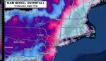
Winter Storm Iola will continue to bring significant snowfall to the Southern Rockies and Southern Plains through Thursday as it begins its long journey that will eventually take it into the Appalachians and Northeast.
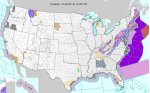
Winter Storm Iola was named Wednesday afternoon by the winter storm naming committee at The Weather Channel. Iola met The Weather Channel naming criteria because by late Wednesday afternoon, the National Weather Service had issued winter storm warnings covering more than 450,000 square kilometers (173,746 square miles) in New Mexico, Texas, Oklahoma and Colorado. Our threshold for naming requires winter-related warnings covering at least 400,000 square kilometers or 2 million people. (The population under warnings was just over 1.8 million at this writing.)
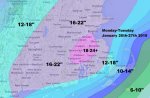
(MORE: Winter Storm Iola Northeast Forecast)
Winter Storm Iola was named Wednesday afternoon by the winter storm naming committee at The Weather Channel. Iola met The Weather Channel naming criteria because by late Wednesday afternoon, the National Weather Service had issued winter storm warnings covering more than 450,000 square kilometers (173,746 square miles) in New Mexico, Texas, Oklahoma and Colorado. Our threshold for naming requires winter-related warnings covering at least 400,000 square kilometers or 2 million people. (The population under warnings was just over 1.8 million at this writing.)
Iola's Southern Plains and Southern Rockies Snow
Snow from Iola began to develop Tuesday night in parts of Colorado and northern New Mexico, and continued to expand Wednesday into the Texas Panhandle.
Through Thursday, snow will continue in the mountains of central New Mexico, in parts of West Texas and western Oklahoma, while rain will be found throughout central and eastern Texas, much of southern Oklahoma and into parts of Arkansas and Louisiana.
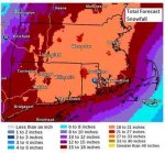
Impressive snowfall rates occurred in New Mexico as well as the Texas Panhandle Wednesday evening as the storm cranked up in intensity. Amarillo experienced snowfall rates as high as 3 inches per hour, and snowfall totals from this single storm have already exceeded the city's snowfall accumulations for the entire season.
Here is a list of notable snowfall totals as of 3 p.m. EST Thursday:
- 16 inches near Edgewood, New Mexico
- 14 inches in Sedillo, New Mexico
- 13 inches in Canyon, Texas
- 13 inches reported near Amarillo, Texas
- 11.5 inches reported near Colorado Springs, Colorado
- 9 inches Dalhart, Texas
- 8 inches in Amarillo, Texas
- 8 inches near Tres Ritos, New Mexico
- 5 inches in Cimarron, New Mexico
- 4 inches near Los Alamos, New Mexico
- 2 inches near Santa Fe, New Mexico
- 2 inches near Denver, Colorado
- 1.1 inches near Albuquerque, New Mexico
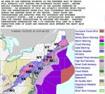
Winter storm warnings have been posted for portions of the Southern Rockies and Southern Plains, including Santa Fe and Amarillo, for moderate to heavy snowfall. Winds gusts of over 30 mph are also possible through Thursday.
*(Fair Use)
http://www.weather.com/storms/winter/news/winter-storm-iola-forecast-southwest-southern-plains
Continue to next post . . . . . .
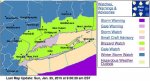
Mid-South - Looks like we will be getting some winter weather. Weather channel announced, we could get snow, ice & rain tomorrow evening, through Saturday morning. High tomorrow predicted around 39 and low around 28.
Suzieq
-----------------------------------
*Winter Storm Iola: Snow for Southern Plains, Southwest and Possibly the Mid-South (FORECAST)
By Linda Lam
Published Jan 22 2015 03:57 PM EST
weather.com
Winter Storm Iola will continue to bring significant snowfall to the Southern Rockies and Southern Plains through Thursday as it begins its long journey that will eventually take it into the Appalachians and Northeast.
Winter Storm Iola was named Wednesday afternoon by the winter storm naming committee at The Weather Channel. Iola met The Weather Channel naming criteria because by late Wednesday afternoon, the National Weather Service had issued winter storm warnings covering more than 450,000 square kilometers (173,746 square miles) in New Mexico, Texas, Oklahoma and Colorado. Our threshold for naming requires winter-related warnings covering at least 400,000 square kilometers or 2 million people. (The population under warnings was just over 1.8 million at this writing.)
(MORE: Winter Storm Iola Northeast Forecast)
Winter Storm Iola was named Wednesday afternoon by the winter storm naming committee at The Weather Channel. Iola met The Weather Channel naming criteria because by late Wednesday afternoon, the National Weather Service had issued winter storm warnings covering more than 450,000 square kilometers (173,746 square miles) in New Mexico, Texas, Oklahoma and Colorado. Our threshold for naming requires winter-related warnings covering at least 400,000 square kilometers or 2 million people. (The population under warnings was just over 1.8 million at this writing.)
Iola's Southern Plains and Southern Rockies Snow
Snow from Iola began to develop Tuesday night in parts of Colorado and northern New Mexico, and continued to expand Wednesday into the Texas Panhandle.
Through Thursday, snow will continue in the mountains of central New Mexico, in parts of West Texas and western Oklahoma, while rain will be found throughout central and eastern Texas, much of southern Oklahoma and into parts of Arkansas and Louisiana.
Impressive snowfall rates occurred in New Mexico as well as the Texas Panhandle Wednesday evening as the storm cranked up in intensity. Amarillo experienced snowfall rates as high as 3 inches per hour, and snowfall totals from this single storm have already exceeded the city's snowfall accumulations for the entire season.
Here is a list of notable snowfall totals as of 3 p.m. EST Thursday:
- 16 inches near Edgewood, New Mexico
- 14 inches in Sedillo, New Mexico
- 13 inches in Canyon, Texas
- 13 inches reported near Amarillo, Texas
- 11.5 inches reported near Colorado Springs, Colorado
- 9 inches Dalhart, Texas
- 8 inches in Amarillo, Texas
- 8 inches near Tres Ritos, New Mexico
- 5 inches in Cimarron, New Mexico
- 4 inches near Los Alamos, New Mexico
- 2 inches near Santa Fe, New Mexico
- 2 inches near Denver, Colorado
- 1.1 inches near Albuquerque, New Mexico
Winter storm warnings have been posted for portions of the Southern Rockies and Southern Plains, including Santa Fe and Amarillo, for moderate to heavy snowfall. Winds gusts of over 30 mph are also possible through Thursday.
*(Fair Use)
http://www.weather.com/storms/winter/news/winter-storm-iola-forecast-southwest-southern-plains
Continue to next post . . . . . .
Last edited:


")


 dislikes mixing the data from two different storms.