Lilbitsnana
On TB every waking moment
Is the lava going in a different direction now?
Not sure what you saw or are seeing.
That livestream link says not available to me and says it was recorded yesterday.

Is the lava going in a different direction now?
Not sure what you saw or are seeing.
That livestream link says not available to me and says it was recorded yesterday.
There are vents open on sides that aren't necessarily showing on some of the livestreams
Sometime yesterday, there were seven vents open (vents open and close/stop on a regular basis), earlier today there were five open, but I haven't checked in last several hours for current count.
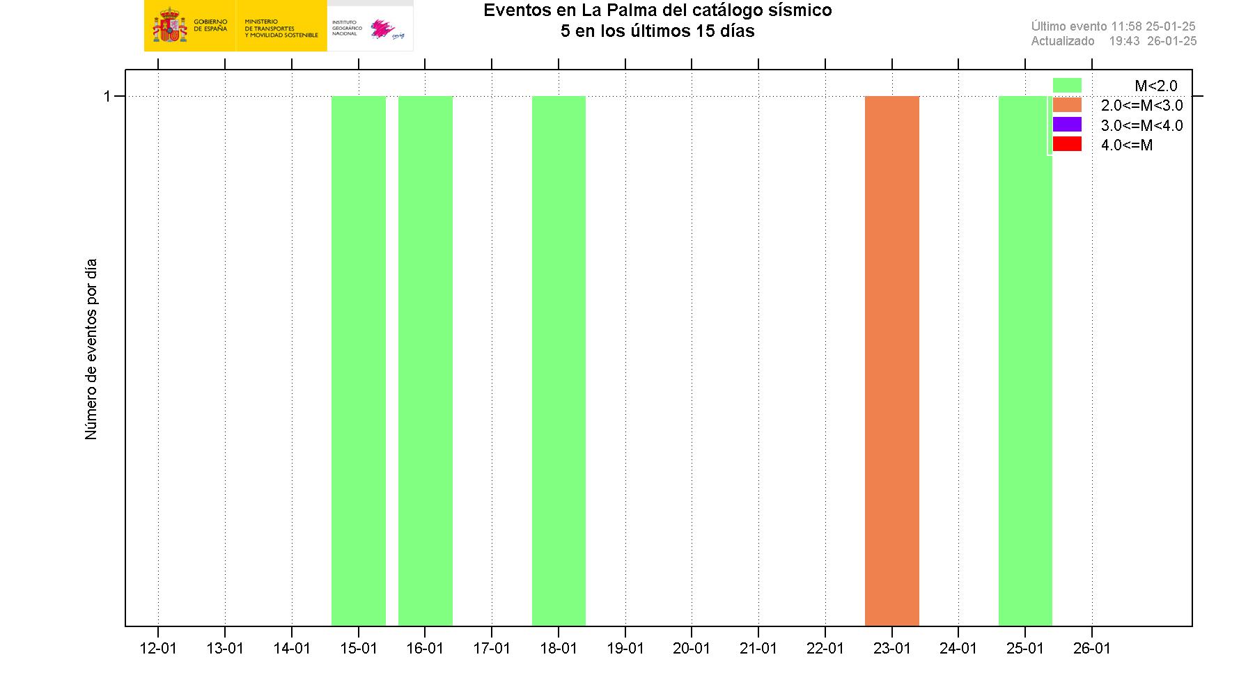
I know they have had 14 earthquakes over 3.0 on the island in the last 21 hours; so things are still interesting.
official reports from terra MODIS and Spanish volcanoe institute, gravitational waves have been observed for the first time ever from this eruption
Observed gravitational waves?from a chat a few minutes ago:
Observed gravitational waves?
What the heck does that mean?
Observed gravitational waves?
What the heck does that mean?

^^ This link doesn't work for me. Does that thread still exist?I started a thread for woo, religion, and politics about this eruption here so that we can keep this thread strictly for the eruption.
UNEX - The all things Woo, Religious, and Political La Palma Volcanic Eruption thread!
Just as the title states, I'll go fetch the links to the other three threads now. https://www.timebomb2000.com/xf/index.php?threads/magma-is-moving-underneath-la-palma-cumbre-vieja-canary-islands-volcano.607399/...www.timebomb2000.com
This means... what?from a chat a few minutes ago:
This means... what?
from a chat a few minutes ago:
official reports from terra MODIS and Spanish volcanoe institute, gravitational waves have been observed for the first time ever from this eruption

Just checked the live camera at the following link. It's black. There is so much smoke/ash that you can see only a small part of the lava flow. The camera was at the top vent when it started to really fountain high, then smoke/ash started obscuring the view almost completely. Creepy. I have no idea what it means.
Now it looks like the smoke/ash is blowing away because you can see the main cones again and most of the lava flow.
View: https://www.youtube.com/watch?v=DFzZyTFQWo8
| 2.5 mbLg | N FUENCALIENTE DE LA PALMA.ILP 2021/10/04 12:21:11 | 14 | +info |
| 3.3 mbLg | NE FUENCALIENTE DE LA PALMA.IL 2021/10/04 12:00:32 | 15 | +info |
| 2.8 mbLg | NE FUENCALIENTE DE LA PALMA.IL 2021/10/04 11:29:52 | 13 | +info |
| 3.4 mbLg | SW VILLA DE MAZO.ILP 2021/10/04 11:22:07 | 12 | +info |
| 2.6 mbLg | W VILLA DE MAZO.ILP 2021/10/04 10:47:31 | 10 | +info |
| 3.1 mbLg | NE FUENCALIENTE DE LA PALMA.IL 2021/10/04 10:43:10 | 14 | +info |
| 3.1 mbLg | NE FUENCALIENTE DE LA PALMA.IL 2021/10/04 09:55:46 III | 14 | +info |
| 3.1 mbLg | W VILLA DE MAZO.ILP 2021/10/04 09:37:49 | 30 | +info |
| 2.8 mbLg | NE FUENCALIENTE DE LA PALMA.IL 2021/10/04 08:58:08 | 12 | +info |
| 2.7 mbLg | SW VILLA DE MAZO.ILP 2021/10/04 08:34:45 | 14 | +info |
| 2.6 mbLg | NE FUENCALIENTE DE LA PALMA.IL 2021/10/04 08:12:42 | 12 | +info |
| 3.2 mbLg | NE FUENCALIENTE DE LA PALMA.IL 2021/10/04 07:59:57 | 13 | +info |
| 2.6 mbLg | NE FUENCALIENTE DE LA PALMA.IL 2021/10/04 07:50:42 | 10 | +info |
| 3.3 mbLg | SW VILLA DE MAZO.ILP 2021/10/04 07:46:32 | 12 | +info |
| 2.7 mbLg | NE FUENCALIENTE DE LA PALMA.IL 2021/10/04 07:38:05 | 10 | +info |
| 3.3 mbLg | NE FUENCALIENTE DE LA PALMA.IL 2021/10/04 07:33:59 |

Bushcraft Bear caught whatever happened from his overlook spot. It's in the last two minutes of this video. Runtime 8 min.
View: https://www.youtube.com/watch?v=9gdQYBIGplo
from what I'm hearing part of the lava dome collapsed.
is that good or bad?

")
")
")
")
")
")