WEATHER INBOUND STORM FOR PACIFIC NORTHWEST

mzkitty

I give up.
Extreme winter storms expected across US from California to Maine
1h ago

Twenty-four states, from California to Maine, are on alert for extreme cold, freezing rain, heavy snow and avalanche danger on Tuesday.

Western storms, which brought snow to parts of California and the West are headed east, bringing an icy mix, severe weather and a tornado threat to the South and Northeast.

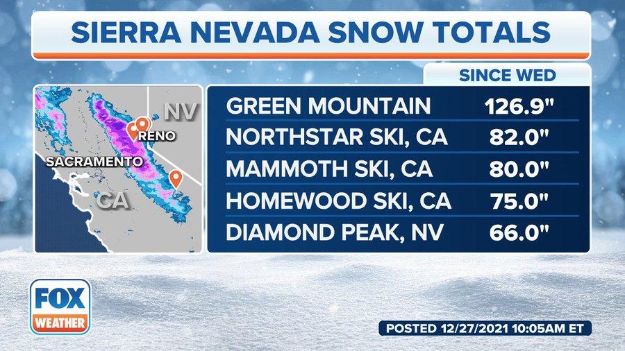
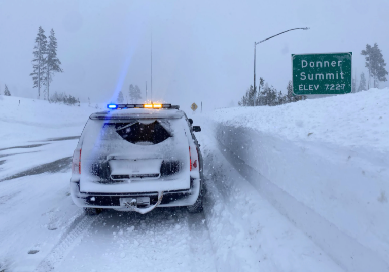
A few more storms will move through the West over the next few days, bringing more heavy snow for the mountains where an avalanche warning has been issued from California to Colorado. Locally, there could be an additional 2 to 4 inches of snow.

In southern California, 2 to 3 additional inches of rain are possible, which could cause minor flooding.
In the Northeast, as one storm move out, another will move in, with more icy roads forecast Tuesday night into Wednesday morning.

MORE: 'So difficult': Northwest cold forces some into shelters

Blizzard conditions raged the Midwest on Monday from the Dakotas into Minnesota, where winds gusted near 50 miles per hour and almost 2 feet of snow fell.

Between 3 to 6 inches of snow are expected in the Midwest, with up to 4 inches possible in the Northeast over the next few days.

From Chicago to Green Bay, Wisconsin, and the Twin Cities, a winter weather advisory has been issued where a mix of freezing rain and snow is expected on Tuesday. Roads could become very slick.

In the South, Mississippi, Alabama and Tennessee are under a threat for severe thunderstorms with damaging winds and a few tornadoes on Wednesday.

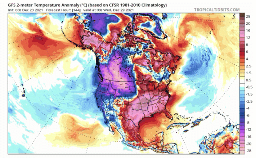
The northern half of the country is expecting an arctic outbreak, with some of the coldest arctic air so far this season. The air will move from the northern Rockies into the Upper Midwest.

Wind chills in parts of Montana and the Dakotas have dropped close to 30 to 50 degrees below zero. This air mass will move east into the western Great Lakes and the upper Midwest. The actual temperature is forecast to be well below zero for places like Minneapolis.

As the new year begins, afternoon temperatures will be well below zero in Fargo, North Dakota, and minus 2 in Minneapolis. Temperatures in Denver and Kansas City, Missouri, will also be below freezing.

Extreme winter storms expected across US from California to Maine (msn.com)
 

Doomer Doug

TB Fanatic
We are now in the ground/road freeze final phase. The snow/slush/rain mode will be in full swing weds and thursday. Downtown street moisture will freeze/thaw/freeze again. The good news is it will mosty be done by this weekend. Temps in the 40 range.
 

marsh

On TB every waking moment

Record Snowfall Blankets West Coast

TUESDAY, DEC 28, 2021 - 02:50 PM
Climate change warrior Greta Thunberg must be speechless or at least ignoring the "science" as the University of California, Berkeley's Sierra Snow Laboratory reported the snowiest December on record.

UC Berkeley's snow lab, located near Donner Pass in the northern Sierra Nevada, recorded the snowiest December at 193.7 inches – over 16 feet, smashing the old December record of 179 inches set back in 1970.

1640749395099.png

As much as 10 feet of snow has fallen in parts of the Sierra Nevada since last Wednesday.


The latest GFS snow model shows the incredible amount of snow dumped across Sierra Nevadas. There is even more snow slated for next week.


The Sierra Nevada snowpack is a critical source of water for California reservoirs. Considering much of the state is in a severe drought. The above-average snowpack is a promising sign for next year.


Here are some of the incredible images of the feet of snow from the Sierra Nevada area (pictures provided by LA Times):

California Highway Patrol cruiser driving through Donner Summit on Dec. 25.


The UC Berkeley Sierra Snow Lab has feet of snow.


Vehicles are buried under the feet of snow at Tahoe Donner ski resort.


What happens next could be a polar chill that sweeps across the US Lower 48. We noted this could happen as early as Dec. 9.
"Beyond the holidays, Canada's and the NW's polar chill looks set to finally descend south and spread east by the New Year — this will prove a stark shift for many, as many regions flip from anomalous warmth to an exceptional freeze, almost instantaneously," explained weather website Electroverse.


US natural gas futures jumped on Monday as storms brought snowfall to parts of the US, and colder outlooks were seen for early January.


Greta Thunberg and her climate gang of children are seemingly ignoring record snowfall in California while continuing to tell the world we're all going to burn if we don't invest in green energy.
 

Doomer Doug

TB Fanatic
The temps will be freezing or below the next 24 hours.

Weds: 30/21 F

Thursday: 37/28 F 1 inch snow

Friday: 34/23 F

Saturday: 36/28 F

Sunday: 41/37

From 1-2-22 to 1-12-22 the high temps will be 40 F plus every day.:eleph:
We just have to get through Weds to Friday
 

bw

Fringe Ranger
I do not understand how those little hummingbirds survive. They were six inches from me when I put out a feeder this morning, like the help was late serving the breakfast bar.
 

marsh

On TB every waking moment
We are dipping down into frost area for the next week. It doesn't look like it will get below freezing here, but close. It is much colder in the mountains. (Time to make sure my grapefruit is picked and my semi-tropicals covered.
 

Doomer Doug

TB Fanatic
They just implemented a weather advisory from 0001, some 5 hours from now, to 12pm noon Thursday with 1 to 4 inches of snow expected down to valley floor. The last burst before the 40 plus highs the first 2 weeks of 2022 happen.
It is 27 F right now and will stay that way till morning.
 

Doomer Doug

TB Fanatic
Weather advisory now in effect till 12 noon.. temps in the 27 range till early am with snow

Last round though the roads etc will be a real mess with all the ice
Thursday morning.
 

medic38572

TB Fanatic
Weather advisory now in effect till 12 noon.. temps in the 27 range till early am with snow

Last round though the roads etc will be a real mess with all the ice
Thursday morning.
Here is our weather advisory Doug.
Right now it's snowing fine hard snow wind about 9mph and 12 degrees.

Special Weather Statement Issued December 29 At 8:01am Mst By Nws Spokane


Dangerously Cold Temperatures Will Impact Eastern Washington And North Idaho Through The Remainder Of The Workweek And Into The First Half Of The Weekend With A Persistent Arctic Air Mass. High Temperatures Will Only Warm Into The Single Digits And Teens.

Meanwhile Overnight Lows Will Likely Drop Into The Single Digits To Below Zero. Portions Of The Region Will Also See Dangerous Wind Chills Of Minus Ten To Minus 20 Early This Morning And Again On Friday.

With The Extreme Cold...Frost Bite And Hypothermia Will Occur Much Faster. If Outdoors, Remember To Dress In Layers And Cover Exposed Skin. Unprotected Pipes Will Be Susceptible To Freezing And Bursting. Take Precautions To Protect Pets And Livestock From Extreme Cold.

Areas Of Snow Will Continue To Impact Portions Of The Inland Northwest Through The Week With Widespread Moderate To Locally Heavy Snow Possible Over Southeast Washington And North-Central Idaho On Thursday.
 

Bridey Rose

Veteran Member
Trudged the 3 blocks to the mailbox around the corner this afternoon to mail my rent check.

Managed to stay upright the entire time despite avoiding the work involved in digging my :snta: Yak-trax :rdr:out of the closet and applying them to my boot bottoms. Boy is my butt sore from all of that half-stepping on the packed snow and ice!

Not much plowing was done in the parking lots. A plow came by yesterday to push the snow off the storm drain so the melt water has somewhere to go, but the road through my complex is still thickly packed with snow.

Snow is starting to melt off the south side of my car just in time for another snowstorm tomorrow. Will be glad to see the snow melt completely this weekend when it warms up to above freezing. I'm not even attempting to drive anywhere even though I have a few errands to run and this week off work.
 
Last edited:

Doomer Doug

TB Fanatic
It is 36 F now with rain. We will get a FINAL blast of snow and cold Nrw Year's Eve/Day

Starting on January 2nd to 12 th highs will be 40 F plus EVERY DAY.
We will have flooding and melting issues.
We have got cold issues as late as February, but I think we are mostly done withe the cold
 

Doomer Doug

TB Fanatic
Yeah, 30 F for tonight with 50% chance of 1 inch snow.

New Year's Eve will be 19 F OUCH with no snow etc but that is it.
 

Doomer Doug

TB Fanatic
The end is in sight. It is snowing right now, for 3 or so hours. It will stay at or below freezing all of New Year's eve, with lows around 22 F. It will do the same New Year's Day until it finally warms up Sunday morning.
We will then have temps in the high 40's F until January 14th.

It will be 50 F on Thursday.

The normal temp pattern resumes. Thursday will have a high of 50 F and a low of 46. Several days will have highs of 45 with rain and 41 F
I heard at least one transient froze to death but I don't listen to local media, tv or radio anymore.:D
Massive utility bills, much flooding damage and an unknown number of dead transients from hypothermia are the residue.
It will be sunny and cold the next 48 hours.
 

Doomer Doug

TB Fanatic
The pipes will refreeze again, since it will get down to 22 F at 5pm today and then stay frozen till Sunday/ Monday. It will be a mess since the heavy rain will combine with the snow melt.

J F & P is on Johnson Creek and it ALWAYS floods when heavy rain and snow melt combine. :boohoo:
New Year's Eve will be 22 F with frozen ice everywhere- roads, sidewalks, etc.

I'm staying in my nice warm apartment.:kaid:

I visited Paris, France on New Year's Eve of 1973. Never did anything else on New Year's Eve for the last 50 years.:jstr:
 

Doomer Doug

TB Fanatic
It will be below freezing from Friday 1700, today, to 1700 Saturday much of the temps at 22 to 25 F or so. It will be 23 F at midnight.
It will finally rise to 41 F at noon on Sunday.
 

Doomer Doug

TB Fanatic
Likely drunken transients dead from hypothermia, combined with car wrecks from ice on the roads. Hell, not sure if that bitch brown shut everything down.
 

Pinecone

Has No Life - Lives on TB
Don't look now, DD, but more misery in the form of wind and lots of rain is coming, starting Sunday and continuing through the week. I'm done with winter, and it isn't quite January yet.
 

Doomer Doug

TB Fanatic
Yep Sunday afternoon gives us a wind advisory. Which means all the soggy trees, in the soggy ground, may fall over and some

lose power: 20 to 30 mph with gusts up to 40 mph?
In addition 6 pm tonight starts the flood watch. Not a warning but a FLOOD WATCH.
Sheesh, at least the highs will be 40 F plus.

Unless the downtown electric vaults flood I will be okay. :kaid: :kaid:
Not much of an issue for me this last two seek "climate event."
I wonder how many transients etc died mot much on the media. Can't make the liberals look bad. The tents stayed up in the park blocks.
 

medic38572

TB Fanatic
Yep Sunday afternoon gives us a wind advisory. Which means all the soggy trees, in the soggy ground, may fall over and some

lose power: 20 to 30 mph with gusts up to 40 mph?
In addition 6 pm tonight starts the flood watch. Not a warning but a FLOOD WATCH.
Sheesh, at least the highs will be 40 F plus.

Unless the downtown electric vaults flood I will be okay. :kaid: :kaid:
Not much of an issue for me this last two seek "climate event."
I wonder how many transients etc died mot much on the media. Can't make the liberals look bad. The tents stayed up in the park blocks.

While your basking in sunshine Doug :lol: will take this with a badge of honor. :D

1Weather
Winter Storm Warning Issued January 02 At 12:03pm Mst Until January 03 At 8:00pm Mst By Nws Spokane ...Localized Blowing And Drifting Snow Sunday Into Monday.

Another Round Of Moderate To Heavy Snow Sunday Night Into Monday... .Gusty Southeast Winds Will Cause Drifting Snow Across The Palouse, Camas Prairie, And Pomeroy Today Into Monday.

The Threat For Blowing And Drifting Snow Will Expand North And West Toward Ritzville...Davenport...And Airway Heights Sunday Night. Snow That Is On The Ground Now Will Drift Across Roads And Possibly Cause Significant Visibility Reductions.

Another Round Of Moderate To Locally Heavy Snow Will Develop Over The Cascades Sunday Afternoon And Spread Into Northeast Washington And North Idaho By Monday Morning. ...

Winter Storm Warning Remains In Effect From 4 Pm This Afternoon To 7 Pm Pst Monday...

* What...Heavy Snow Expected. Total Snow Accumulations Between 5 And 10 Inches Possible In The Valleys And 8 To 14 Inches For The Mountains. Winds Gusting As High As 35 Mph On Exposed Ridgetops.

* Where...Eastport, Sandpoint, Colville, Northport, Bonners Ferry, Orin-Rice Road, Athol, Newport, Flowery Trail Road, Chewelah, Deer Park, Springdale-Hunters Road, Kettle Falls, Schweitzer Mountain Road, And Priest River. * When...From 4 Pm This Afternoon To 7 Pm Pst Monday.

* Impacts...Roads, And Especially Bridges And Overpasses, Will Likely Become Slick And Hazardous. Travel Could Be Very Difficult To Impossible.

he Hazardous Conditions Could Impact The Monday Morning Commute. ‎1Weather: Forecast and Radar picture message or video message was sent using Multimedia Messaging Service.
 

Pinecone

Has No Life - Lives on TB
That sounds like it'll leave a mess, medic38572. Got your snow shovel and aspirin ready? (Guess I won't whine about a little wind and rain here. :D )
 

gonewacky

Veteran Member
lose power: 20 to 30 mph with gusts up to 40 mph?
I'm just 100 miles east of you at the 2000 ft level. That's why I got more gas for the genset today. have snow in the forecast all week.

Winter Storm Warning
WAZ520-521-030200-
/O.CON.KPDT.WS.W.0001.220103T0000Z-220104T0000Z/
East Slopes of the Washington Cascades-Simcoe Highlands-Including the cities of Appleton, Cle Elum, Cliffdell, Goldendale, and Bickleton
409 AM PST Sun Jan 2 2022
...WINTER STORM WARNING REMAINS IN EFFECT FROM 4 PM THIS AFTERNOON TO 4 PM PST MONDAY...
* WHAT...Heavy snow expected. Total snow accumulations of 12 to 18 inches along the east slopes of the Washington Cascades. Winds
gusting as high as 40 mph.
1641171086164.png

Our happy new years
WIN_20211231_23_45_22_Pro.jpg
 

BadMedicine

Would *I* Lie???
The Matsu Valley in Alaska has have been having one hundred plus mile an hour gust for last 2 days.,

Small planes in Palmer cartwheels & destroyed, trucks blown off road, dumpster, trampolines,, sheds & roofs & siding flying. Had a major freezing rain/ ice storm that covered all the trees about a week ago and had many drooping to the ground under the weight..... now winds breaking them & damaging homes & bringing down powerlines. 20,000 without power, 0 degrees out & windchill in the minus 20-50s. NOT a good time to have a hole in your house!!!

borough issued a "shelter in.place" recommendation...
Headed to check on my goats right now...they are pretty buttoned down and loving life yesterday when the got extra rations for inclimate weather!
 
Top