Solar Grand Solar Minimum part deux

northern watch

TB Fanatic
Perfect winter storm jolts north Asian energy prices
By Aaron Sheldrick, Muyu Xu
DECEMBER 18, 20203:58 AMUPDATED 5 HOURS AGO

TOKYO (Reuters) - As an early winter chill grips China, South Korea and Japan, prices for coal, liquefied natural gas (LNG) and power are rising due to supply crunches and a surge in demand with more cold weather expected.

Chinese benchmark coal is at the highest in eight years and LNG prices hit six-year highs, pushing up electricity prices in Japan where limited nuclear capacity makes the nation vulnerable to fuel price volatility
.

China too is being exposed as an effective ban on coal imports from Australia pushes up domestic prices.

Qinhuangdao coal prices are at 718 yuan ($110) a tonne, compared with coal delivered from the Australian port of Newcastle at $79.50 a tonne.

Chinese industrial activity snapped back to pre-coronavirus growth level in November, driving up power use by 9.4% year-on-year to 646.7 billion kilowatt hours, the National Energy Administration said.

Daily coal use at major coal-fired power plants in eight provinces in eastern China was up 6% as of last week, from the corresponding period a year earlier, while coal inventories are at 85 percent of 2019 levels.

Domestic prices of LNG in China have also surged to 60% more than last year, according to Sublime China Information.

Wholesale prices in China’s manufacturing hub in Jiangsu, Shandong and Zhejiang provinces have shot up as much as 40% in the past week to about 7,500 yuan a tonne, the consultancy said. Imports of LNG into China in December were set to hit a record high.

Prices for LNG cargoes to be delivered to Asia in January were estimated to be about $12.70 per million British thermal units (BTUs), equivalent to about $660 a tonne.

“Cold weather across China and northeast Asia has ... created a sharp rise in heating demand,” said Robert Sims, research director at Wood Mackenzie.

(Graphic: North Asia cold snap drives coal, LNG and jet fuel prices - )

Reuters Graphic
One year into the coronavirus pandemic, which crushed the energy market and sent oil prices into negative territory and LNG to record lows, the return of winter weather has created new volatility and pushed prices sharply higher.
Temperatures are expected to be below historical averages in Tokyo, along with Seoul, Beijing and Shanghai, through year-end, according to Refinitiv weather data, keeping pressure on prices.
(Graphic: Asia weather forecast - )
ADVERTISEMENT

Reuters Graphic
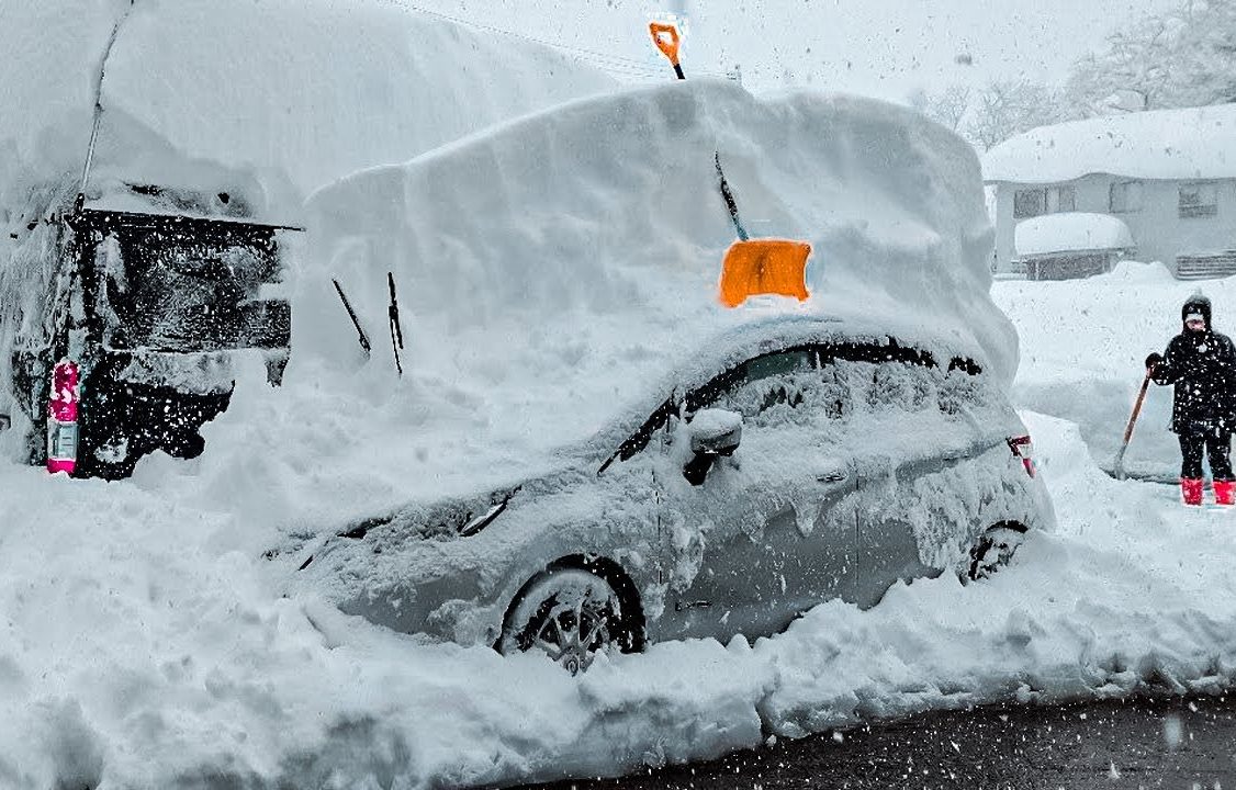
Japan is experiencing record snowfalls, causing power shortages, stranding villages and snarling up traffic.
Some parts of the country are bracing for as much as 80 cm (32 inches) of snow as the cold snap grips much of the country.

With only three nuclear reactors operating and disruptions of supplies of other fuels, Japan’s regional utilities have been transferring power between regions to fill shortages, according to the companies involved.

“We are prepared to take all possible measures to secure power including procurement from the electricity market,” Takashi Morimoto, president of Kansai Electric Power, said on Friday.

(Graphic: Japan daily spot power price highs since April 2018 - )

Reuters Graphic
($1 = 6.5406 Chinese yuan renminbi)

Reporting by Aaron Sheldrick and Yuka Obayashi in Tokyo, Aizhu Chen and Jessica Jaganathan and Heekyong Yang in Seoul; Editing by Edmund Blair

Perfect winter storm jolts north Asian energy prices | Reuters
 

northern watch

TB Fanatic
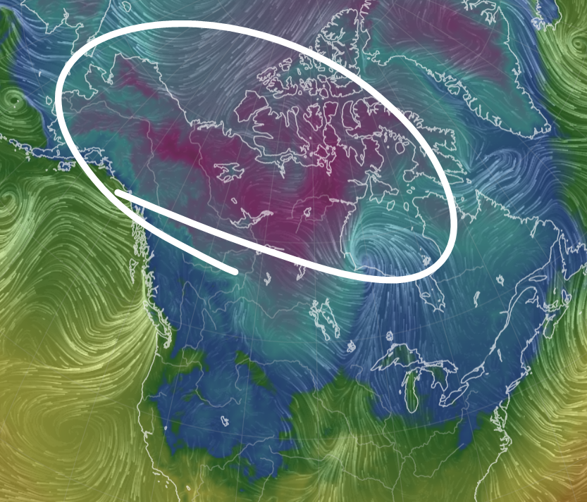
1608330335256.png

EpioK1uWMAMMyRD
 

northern watch

TB Fanatic
Another Big One? New Storm Expected On Christmas Week

BY TYLER DURDEN
Zero Hedge
FRIDAY, DEC 18, 2020 - 14:40

Tens of millions of people are still digging out from the wicked snowstorm that dumped feet of snow across some parts of the Northeast. Ahead of Christmas week, weather models are suggesting another storm is possible.

According to ABC News, a new storm will traverse the U.S. from the West Coast to the central U.S. by Wednesday. Snow will be primarily to the north and rain and thunderstorms in the South and Ohio Valley.


By Christmas Eve, the system will move east with heavy rain and thunderstorms. With the colder air, the rain will turn to snow from the Great Lakes to the southern Appalachians.

Meteorologists from BAMWX pointed out this week "another big one" is possible for Christmas week.

"Current 500mb pattern day of today's storm on the left. A LOT of similarities for the #Christmas storm on the charts via the EPS day 8. The smoothed-out ensemble means cant see some of the details the op sees but you get the point. Another big one possible...," BAMWX said.

BAMWX discusses next week's storm in more depth:

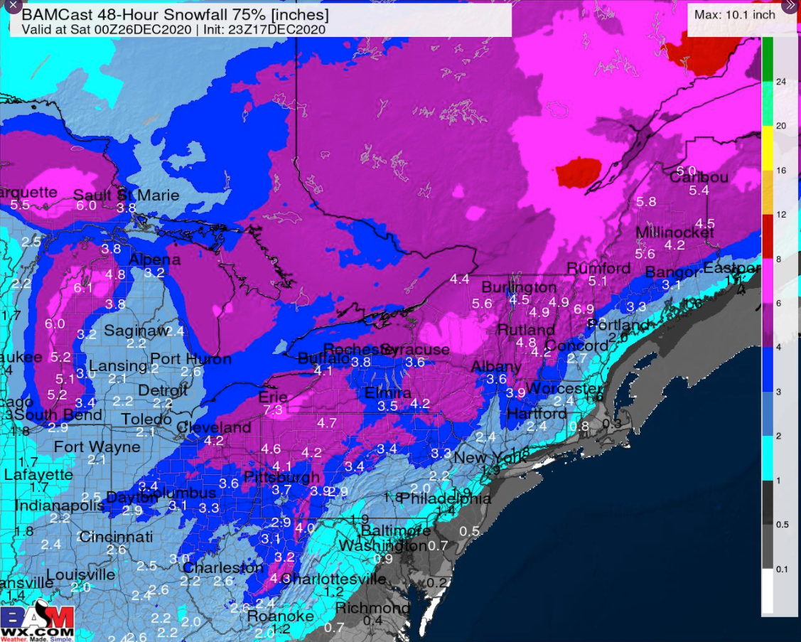
"For the 48hr period from 7 pm 12-23 to 7 pm Christmas Day the blend of models 75th percentile shows us that we have some ensemble support for the snow of some kind," the weather consultancy group said.

2020-12-18_10-32-17.png


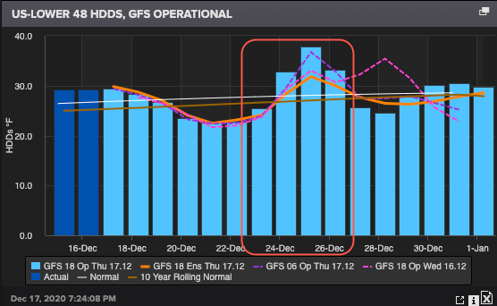
Natural gas demand is expected to rise across the US-Lower 48 as heating degree days are expected to surge above trend, signaling colder weather is ahead for next week that will force Americans to turn up their thermostats.

2020-12-18_10-34-17.png


Weather models are expected to change over the coming days - nothing is certain at the moment.
19,24945


Another Big One? New Storm Expected On Christmas Week | ZeroHedge
 
Last edited:

TxGal

Day by day
New York Man Rescued After 10 Hours In Snow-Buried Car - Ice Age Now

New York Man Rescued After 10 Hours In Snow-Buried Car
December 18, 2020 by Robert

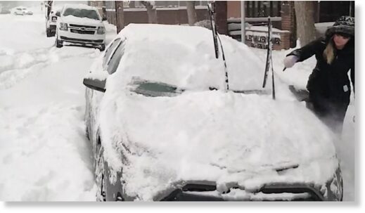
Tioga County man’s car was buried in 4 feet (1.3 m) of snow for 10 hours.

Tioga-County-Snow-Buried-Car.png

Photo credit: New York State Police

New York State Police say 58-year-old Kevin Kresen of Candor had made several 911 calls after his car ran off the road on Route 17 near Campville.

However, even though he had made the 911 calls, no one could find him.

On Thursday, when State Police Sergeant Jason Cawley learned that no one had been able to locate Kresen’s vehicle, he joined the search on Route 17.

When Cawley saw what looked like a row of mailboxes covered in snow, he started pushing the snow away in order to find the addresses for a location. Instead, he hit a windshield of a car. Kresen was inside.

Kresen told police that he went off the road and then a plow went by, covering the car with 4 feet of snow. He was in the car with no heat for 10 hours.

Tioga County Man Rescued After 10 Hours In Snow-Buried Car

State Trooper Finds Tioga Driver Stranded in Snow for Ten Hours
 

TxGal

Day by day
Look at this video from Binghamton New York - Ice Age Now

Look at this video from Binghamton New York
December 18, 2020 by Robert

Binghampton was hit by record-breaking snowfall yesterday. Snowfall waist-deep.

(Video won't copy over for me, please go to the link)

Much like the rest of the area, the City of Binghamton remains under a state of emergency as crews continue to work clearing the streets.

More than three feet of snow. More than a meter.

My guess is that the residents of Binghampton are not too overly concerned about global warming today.

Binghamton Working to Dig Streets Out From Record Snowfall
 

TxGal

Day by day
Record snowfall in Oklahoma, Massachusetts, Rhode Island, Pennsylvania, New York - Ice Age Now

Record snowfall in Oklahoma, Massachusetts, Rhode Island, Pennsylvania, New York
December 18, 2020 by Robert

Boston almost doubles its previous snowfall record for the day. Pennsylvania city hit by the most snowfall – ever – from a single storm.

Binghamton-NY-on-Thursday-17-Dec-2020-1024x722.jpg

Binghamton, N.Y., on Thursday, Dec. 17, 2020 – From Social Media

Record-breaking snowfall sweeps across Oklahoma

Breaks record set more than 100 years ago

Just west of Yukon, Oklahoma City received 2.7 inches of snow, breaking a record set in 1911.

See video of a field in Yukon covered in snow:
https://uk.news.yahoo.com/winter-flurry-brings-record-snowfall
 

TxGal

Day by day
Adapt 2030 has a new podcast out:

N. Hemisphere Record Snow Explained by Bigger Flakes: (The Gaslight) - YouTube

N. Hemisphere Record Snow Explained by Bigger Flakes: (The Gaslight)
7,391 views • Premiered 11 hours ago

View: https://youtu.be/Hc08sbqyrYk

Run time is 11:17

Synopsis provided:

Hourly Snowfall totals termed "Unfathomable" occurring in the USA during Winter Storm Gail, Japan with its seven foot storm and Europe with 6+ feet in two days. The media tells us it a fluffier type of snow that stacks higher than regular snow, so what is really happening across the N. Hemisphere?
 

TxGal

Day by day
Deny the Fake Consensus - by Dr Roger Higgs - Electroverse

fake-consensus-e1608291425995.jpg


DENY THE FAKE CONSENSUS — BY DR ROGER HIGGS
DECEMBER 19, 2020 CAP ALLON

“CO2 climate innocence in 500 words: paleoclimatological-astrophysical literature synthesis by an impartial geologist” — Dr Roger Higgs, Geoclastica Ltd, UK, 16 Dec 2020, researchgate.net.

The below 500-word abstract is the culmination of 5 years of independent research of the entire scientific literature relevant to climate change (not just ‘climate science’, which is fatally biased by its dependence (for funding) on public belief in a ‘climate emergency’ due to ‘man-made’ warming).

I’m a professional geologist.

My hope is that other scientists, upon reading this abstract, will quickly appreciate CO2’s obvious innocence, and spread the truth to colleagues, friends and family. For the well-being of society and your children, grandchildren, etc., it falls to us to deny the fake ‘consensus’ (of CLIMATE scientists only), and stop mainstream media organisations peddling ignorance-based misinformation to the trusting public, such as the BBC’s Climate Basics: CO2 Explained.

These nine facts jointly show that coincidence of modern warming (began 1910) and rising industrial carbon dioxide (CO2; from ~1850) was accidental, not causal:

1)
Warming but not CO2 was interrupted by a 30-year (y) decline and 15-y pause (1):


McInnes 2020. Temperature-CO2-sunspots graph 1850-2020

2) Milankovitch orbital cycles control longer-term (104-105 y) temperature oscillations, e.g. Quaternary ice-age glacials and interglacials (2, 3).

3) Quaternary temperature changes preceded CO2 (emitted or absorbed by oceanic warming or cooling), “very closely” (3), lagging <400 y (4, 5).

4) Overlaid on these Quaternary oscillations are briefer 50-2,000-y temperature fluctuations (fig4c of 6), often ascribed to unsteady solar output (7, 8, 9, 10, 11). This temperature-Sun correlation is most obvious for Late Holocene time (best proxy resolution): both decrease from 1AD to ~1700AD (Little Ice Age, LIA), in ‘sawtooth’ fashion, then surge sawtooth-style into the 20th century (e.g. cross-compare 12 fig11 vs 13 fig7a). Matching peaks and troughs reveal a 50-150-y temperature lag attributable to ocean circulation (14) and thermal inertia (15). Ocean temperature is possibly controlled by solar magnetic output (SMO), governing cloudiness (16).

5) IPCC (17) ignored the time-lag (“solar variations cannot explain global mean surface warming over the past 25 years, because solar irradiance has declined”), yet in the same report admitted “The ocean’s huge heat capacity and slow circulation lend it significant thermal inertia” (18), causing a lag of “many decades” (15).

6) After the Holocene Climatic Optimum (sic) peak in ~5000BC, global cooling (until the LIA (19)) accompanied rising CO2, the “Holocene temperature conundrum” (20).

7) Similarly, for much of Phanerozoic time, CO2 (up to 1000s ppm) was non- or anti-correlated with temperature (21, 22), an exception being the Quaternary glacials, when strong ocean cooling lowered atmospheric CO2 to below 200ppm (3).

8) SMO’s surge since 1700 is the strongest (amplitude) and highest for >9,000 y (23 fig3a; 24 figS13). SMO grew 130% in the 20th century, peaking in 1991 (25 fig3). This surge alone can explain modern warming, given the similar proportionality of earlier surges and correlative warmings (compare graphs in ‘4’ above).

9) IPCC sees total solar irradiance (TSI) as nearly irrelevant to climate (26; 27 figSPM.5). TSI indeed varies little, unlike SMO, which fluctuates in concert with TIC, but proportionally much more (cf. 28 fig1). IPCC did not mention SMO (27).

These 9 facts suggest that CO2’s greenhouse effect, logarithmically declining and already “well into the saturation regime” (29), is negated by overlooked natural feedbacks. An important but poorly quantified negative feedback is aerosol increase due to growing emissions of biogenic volatile organic compounds (BVOCs) by forests fertilized by rising CO2 (30, 31, 32). IPCC stated “total global BVOC emissions have large uncertainties” (33), but ignored BVOC feedback (27 figSPM.5). Climate models’ proclivity to run too hot (34) may reflect this oversight. I predict that global warming due to the Sun’s 20th-century surge to its 1991 peak will continue until late this century, thanks to ocean-lag (17). Meanwhile CO2 will slowly rise nearer to the optimum for plants (~1000ppm; 35).

For a list of the 35 references, as well as a wealth of additional information, click through to Dr Roger Higgs’ Research Gate publication, linked here.
 

Windwood

Contributing Member
Deny the Fake Consensus - by Dr Roger Higgs - Electroverse

fake-consensus-e1608291425995.jpg


DENY THE FAKE CONSENSUS — BY DR ROGER HIGGS
DECEMBER 19, 2020 CAP ALLON

“CO2 climate innocence in 500 words: paleoclimatological-astrophysical literature synthesis by an impartial geologist” — Dr Roger Higgs, Geoclastica Ltd, UK, 16 Dec 2020, researchgate.net.

The below 500-word abstract is the culmination of 5 years of independent research of the entire scientific literature relevant to climate change (not just ‘climate science’, which is fatally biased by its dependence (for funding) on public belief in a ‘climate emergency’ due to ‘man-made’ warming).

I’m a professional geologist.

My hope is that other scientists, upon reading this abstract, will quickly appreciate CO2’s obvious innocence, and spread the truth to colleagues, friends and family. For the well-being of society and your children, grandchildren, etc., it falls to us to deny the fake ‘consensus’ (of CLIMATE scientists only), and stop mainstream media organisations peddling ignorance-based misinformation to the trusting public, such as the BBC’s Climate Basics: CO2 Explained.

These nine facts jointly show that coincidence of modern warming (began 1910) and rising industrial carbon dioxide (CO2; from ~1850) was accidental, not causal:

1)
Warming but not CO2 was interrupted by a 30-year (y) decline and 15-y pause (1):


McInnes 2020. Temperature-CO2-sunspots graph 1850-2020

2) Milankovitch orbital cycles control longer-term (104-105 y) temperature oscillations, e.g. Quaternary ice-age glacials and interglacials (2, 3).

3) Quaternary temperature changes preceded CO2 (emitted or absorbed by oceanic warming or cooling), “very closely” (3), lagging <400 y (4, 5).

4) Overlaid on these Quaternary oscillations are briefer 50-2,000-y temperature fluctuations (fig4c of 6), often ascribed to unsteady solar output (7, 8, 9, 10, 11). This temperature-Sun correlation is most obvious for Late Holocene time (best proxy resolution): both decrease from 1AD to ~1700AD (Little Ice Age, LIA), in ‘sawtooth’ fashion, then surge sawtooth-style into the 20th century (e.g. cross-compare 12 fig11 vs 13 fig7a). Matching peaks and troughs reveal a 50-150-y temperature lag attributable to ocean circulation (14) and thermal inertia (15). Ocean temperature is possibly controlled by solar magnetic output (SMO), governing cloudiness (16).

5) IPCC (17) ignored the time-lag (“solar variations cannot explain global mean surface warming over the past 25 years, because solar irradiance has declined”), yet in the same report admitted “The ocean’s huge heat capacity and slow circulation lend it significant thermal inertia” (18), causing a lag of “many decades” (15).

6) After the Holocene Climatic Optimum (sic) peak in ~5000BC, global cooling (until the LIA (19)) accompanied rising CO2, the “Holocene temperature conundrum” (20).

7) Similarly, for much of Phanerozoic time, CO2 (up to 1000s ppm) was non- or anti-correlated with temperature (21, 22), an exception being the Quaternary glacials, when strong ocean cooling lowered atmospheric CO2 to below 200ppm (3).

8) SMO’s surge since 1700 is the strongest (amplitude) and highest for >9,000 y (23 fig3a; 24 figS13). SMO grew 130% in the 20th century, peaking in 1991 (25 fig3). This surge alone can explain modern warming, given the similar proportionality of earlier surges and correlative warmings (compare graphs in ‘4’ above).

9) IPCC sees total solar irradiance (TSI) as nearly irrelevant to climate (26; 27 figSPM.5). TSI indeed varies little, unlike SMO, which fluctuates in concert with TIC, but proportionally much more (cf. 28 fig1). IPCC did not mention SMO (27).

These 9 facts suggest that CO2’s greenhouse effect, logarithmically declining and already “well into the saturation regime” (29), is negated by overlooked natural feedbacks. An important but poorly quantified negative feedback is aerosol increase due to growing emissions of biogenic volatile organic compounds (BVOCs) by forests fertilized by rising CO2 (30, 31, 32). IPCC stated “total global BVOC emissions have large uncertainties” (33), but ignored BVOC feedback (27 figSPM.5). Climate models’ proclivity to run too hot (34) may reflect this oversight. I predict that global warming due to the Sun’s 20th-century surge to its 1991 peak will continue until late this century, thanks to ocean-lag (17). Meanwhile CO2 will slowly rise nearer to the optimum for plants (~1000ppm; 35).

For a list of the 35 references, as well as a wealth of additional information, click through to Dr Roger Higgs’ Research Gate publication, linked here.
That's a LOT of information!
 

TxGal

Day by day
Adapt 2030 has a new podcast out:

Antarctica Cycle, Sahara Winter Storm and the Procession Shift - YouTube

Antarctica Cycle, Sahara Winter Storm and the Procession Shift
12,886 views • Premiered 22 hours ago

View: https://youtu.be/MJkfU8bvo1k

Run time is 8:03

Synopsis provided:

As we shift signs from Pisces to Aquarius in the procession of the equinox, a quickening of energies is expected which would explain the 30,000 earthquakes in Antarctica a 20X increase. Record snows are blanketing the N. Hemisphere leaving forecasters shocked at the depths and speed of accumulations.
 

TxGal

Day by day
The Oppenheimer Ranch Project has a new podcat out (there are climate references in there):

The Great Conjunction - Tecumseh's Curse - Curse Of The President - Age of Aquarius - Mayan Prophesy - YouTube

The Great Conjunction - Tecumseh's Curse - Curse Of The President - Age of Aquarius - Mayan Prophesy
Unlisted 82 views • Dec 19, 2020

View: https://youtu.be/jMJMBykxQ-8

Run time is 13:08

Synopsis provided:

The great conjunction of Jupiter and Saturn — The dawn of a new era? http://bit.ly/2JYHyJc
Jupiter and Saturn Form ‘Double Planet’ for First Time since Middle Ages https://bit.ly/380E017
Curse of Tippecanoe http://bit.ly/37xAvjJ
The December 21, 2020 “Great Conjunction” of Jupiter and Saturn https://bit.ly/384PGzW
Great conjunction http://bit.ly/34pnLcI
AMO (Climate) and its relation to the Great Conjunction https://bit.ly/3apDmNf
 

TxGal

Day by day
Impressive light pillars recorded over Tyumen in Western Siberia -- Earth Changes -- Sott.net

Impressive light pillars recorded over Tyumen in Western Siberia

Olga Gertcyk
The Siberian Times
Tue, 08 Dec 2020 02:55 UTC

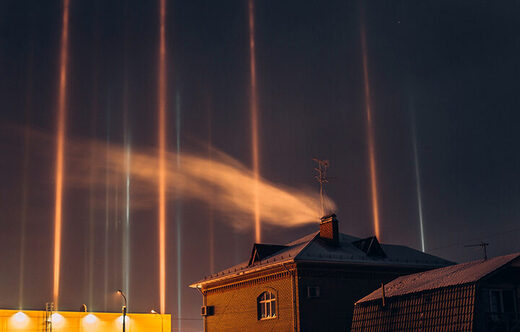
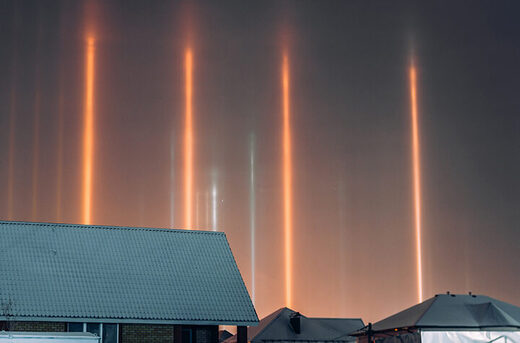
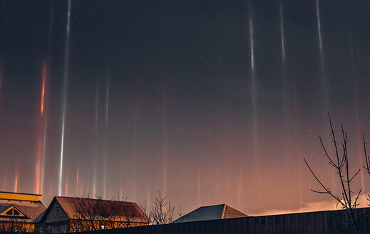
Light pillars over Siberia
© Yevgenia

Local resident and photographer Yevgenia shared pictures and video of the spectacular natural phenomenon, recorded at the beginning of December in Tyumen.

Dozens of vertical lights appeared in the sky just before midnight, and were visible for several minutes, prompting many residents to rush outside to enjoy the sight.

She posted on her Instagram: 'It was exactly midnight and quite cold outside, -15C degrees. I quickly grabbed the camera, pulled on my pants, put a pair of the most compact lenses in my jacket pockets, 50mm and 35mm, and run outside.

'My hands were stiff from the cold, but I managed to capture the lights!

View: https://youtu.be/i_nOlKPESCE

Run time is 0:48

'They disappeared before my eyes. It was the middle that vanished first, and then this emptiness from the middle began to creep up and down, gradually eating up the pillars.'

Light pillars over Siberia
© Yevgenia

Light pillars are more common for higher latitudes than Tyumen; for them to appear several weather conditions like air temperature below zero, presence of diamond-shaped ice crystals with smooth edges in the air and a slight wind should coincide.

Light pillars over Siberia
© Yevgenia

Like the Northern Lights, pillars of light are common during the Arctic winter and in recent weeks they were observed on the Yamal Peninsula.

They are formed from reflection of ice 'flakes' suspended in the air, so that during their appearance the light particles are not exactly where they appear, but are a reflection of the original source of the photons, which can be the Moon, the Sun or the public lighting.
 

TxGal

Day by day
Snowfall tally at Alyeska Ski Resort in Alaska at 260 inches - 8 feet more than last season -- Earth Changes -- Sott.net

Snowfall tally at Alyeska Ski Resort in Alaska at 260 inches - 8 feet more than last season

Loren Holmes
Anchorage Daily News
Sat, 19 Dec 2020 20:06 UTC

Skiers wear masks while waiting in a lift line at Alyeska Resort on opening day, Friday, Dec. 18, 2020 in Girdwood.

Alyeska Resort opens for the season with a 100-inch base and new pandemic guidelines.

Alyeska Resort starts counting how much snow falls at the top of the mountain each year on Oct. 1.

By opening day this year, the tally was 260 inches — over 8 feet more than last year.

(Read more here)
 

TxGal

Day by day
Vermont - Several feet of snow in a matter of hours - Video - Ice Age Now

Vermont – Several feet of snow in a matter of hours – Video
December 20, 2020 by Robert

Record snowfall – One of the biggest December storms in history.
________

18 Dec 2020 – “In Southern Vermont, snowfall began just before midnight Wednesday and continued Thursday, pilling up several feet in a matter of hours,” writes Jolie Sherman.

Run time is 01:43

“The Vermont Agency of Transportation says it is one of the biggest December storms in history. While some areas received 18 to 30 inches, Det. Sgt. Richard King with Ludlow Police Department says the town saw an excess of 44 inches (112 cm).

Top 10 December snowstorms (will soon include this latest storm)
“This is incredible. I’ve never seen anything like this before,” said Jerry Scheumann.

“I’ve been living here in New England for seven, eight years now, and Central Minnesota for 30 years before then. So, this is incredible,” said Scheumann.

“Early Thursday morning the Ludlow resident and his wife woke up to more than 30 inches (75 cm) of snow outside their window. Sgt. King says he’s never seen this much snow this soon in December.


TxGal

Day by day
Vicious Feedback Loop brings Intense Winter Conditions across India - Electroverse

Feedback-loop-cold-e1608548472525.jpg


VICIOUS FEEDBACK LOOP BRINGS INTENSE WINTER CONDITIONS ACROSS INDIA
DECEMBER 21, 2020 CAP ALLON

INDIA — Jammu & Kashmir’s 2020/21 winter season is off to a brutal start after the mercury plunged to -6.6C (20F) in Srinagar on December 19, compounding the misery caused by the recent disruptive snowstorms.

Jammu & Kashmir’s winter months are divided into three stages: Stage 1) the intense 40-day period known as “Chillai Kalan” starting Dec. 21, Stage 2) the less intense 20-day spell called “Chillai Khurd”, and finally Stage 3) the 10-days of mild cold entitled “Chille Bache”.

This year, two days before “Chillai Kalan” had even begun, Srinagar recorded the bone-chilling low of -6.6C (20F) — a reading that was not only the lowest of the season so far, but also the second-coldest December temperature of the past decade, according to the region’s meteorological department.

DAL LAKE PARTIALLY FROZEN

“I could not reach the floating vegetable market on the lake today as the lake’s surface was frozen at many places,” said Nazir Ahmad, a vegetable dealer who traverses the ancient lake on his boat every day. He added: “The lake has been freezing during the nights in the past four-five days.”

View: https://twitter.com/AaftabRehman1/status/1340517894564663297


While Dal Lake is known to freeze-over in winter, this long-lasting bought of cold –particularly before “Chillai Kalan” had even commenced– isn’t normal.

View: https://twitter.com/State_Times/status/1339890655913340930

Run time 0:42

VICIOUS FEEDBACK LOOP

The tourist resort of Gulmarg, which is located in the Baramulla district of Jammu & Kashmir, recorded a low -6.4C (20.5F) over the weekend.

As reported by hindustantimes.com, Gulmarg has already had four spells of heavy snow this winter, and winter games have begun on the resort’s slopes.

Leh, in the Union Territory of Ladakh, recorded a low of -13.1C (8.4F).

While Kargil dipped to a -20C (-4F).

And Drass shivered through -20.5C (-4.9F).

Driving all this exceptional cold is the deep snow currently capping the northern mountains. As explained by the India Meteorological Department (IMD), the snow is cooling the northerly winds, and has resulted in the average temperature across India holding some 5C below the norm of late.

The department added that this is setup is working in a vicious feedback loop: the colder the plains, the greater the snowfall in the mountains, and the greater the snowfall in the mountains, the colder the plains.

As a result, most towns and cities across India are at risk of severe bouts of cold this winter season. This has actually been the case since late-September, during which time hundreds of all-time cold records have tumbled, with the “biggies” being the nation’s capital Delhi registering its coldest months of October and November in 58 and 71-years, respectively.

For more:


And:


The COLD TIMES are returning, the mid-latitudes are REFREEZING in line with historically low solar activity, cloud-nucleating Cosmic Rays, and a meridional jet stream flow.

Both NOAA and NASA appear to agree, if you read between the lines, with NOAA saying we’re entering a ‘full-blown’ Grand Solar Minimum in the late-2020s, and NASA seeing this upcoming solar cycle (25) as “the weakest of the past 200 years”, with the agency correlating previous solar shutdowns to prolonged periods of global cooling here.

Furthermore, we can’t ignore the slew of new scientific papers stating the immense impact The Beaufort Gyre could have on the Gulf Stream, and therefore the climate overall.


Prepare accordinglylearn the facts, relocate if need be, and grow your own.
 

TxGal

Day by day
Endicott, New York Remains In State Of Emergency following Record Snowfall - Electroverse

Enicott-sno-e1608542228859.jpg


ENDICOTT, NEW YORK REMAINS IN STATE OF EMERGENCY FOLLOWING RECORD SNOWFALL
DECEMBER 21, 2020 CAP ALLON

The Village of Endicott in Broome County, New York remained in a State of Emergency on Sunday as snow removal efforts continued.

Endicott Police Chief Patrick Garey urged drivers to avoid the Village altogether: “It really increases the chances of an accident and also, all of the vehicles being out really impedes on snow removal operations,” he said.

Garey added that following the record-breaking snow, it took residents a lot longer to clear out their driveways than usual, and that goes for the village crews as they clear the streets in a slow, methodical manner.

View: https://twitter.com/adam_gillwx/status/1339531059071954949


View: https://twitter.com/jenniferwoltjen/status/1339926405078003716


View: https://twitter.com/Livestormchaser/status/1340716343339995140
Run time is 0:34

Village Manager Anthony Bates says crews still have to get to the sidewalks and intersections, but insists that they have made a lot of progress.

National Guard crews also arrived two days ago to clear fire hydrants around the village.

View: https://twitter.com/CharlesPeekWX/status/1339603717943914496
Run time is 1:17

“Outrageous” December snow buried parts of the Mid-Atlantic and Northeast late last week:


Below is timelapse footage of the dramatic buildup in Apalachin, NY, after the nor’easter swept through Friday, December 18:

View: https://twitter.com/isixtyfive/status/1340020153493417991
Run time is 0:32

Nearby Binghamton wound-up with a whopping 42 inches of snow, according to the NWS, smashing the city’s all-time two-day snowfall record:

View: https://twitter.com/NWSWPC/status/1339626999313264640


View: https://twitter.com/JosephChampaign/status/1339567275834261504
Run time is 0:35

The COLD TIMES are returning, the mid-latitudes are REFREEZING in line with historically low solar activity, cloud-nucleating Cosmic Rays, and a meridional jet stream flow.

Both NOAA and NASA appear to agree, if you read between the lines, with NOAA saying we’re entering a ‘full-blown’ Grand Solar Minimum in the late-2020s, and NASA seeing this upcoming solar cycle (25) as “the weakest of the past 200 years”, with the agency correlating previous solar shutdowns to prolonged periods of global cooling here.

Furthermore, we can’t ignore the slew of new scientific papers stating the immense impact The Beaufort Gyre could have on the Gulf Stream, and therefore the climate overall.


Prepare accordinglylearn the facts, relocate if need be, and grow your own.
 

packyderms_wife

Neither here nor there.
Impressive light pillars recorded over Tyumen in Western Siberia -- Earth Changes -- Sott.net

Impressive light pillars recorded over Tyumen in Western Siberia

Olga Gertcyk
The Siberian Times
Tue, 08 Dec 2020 02:55 UTC

Light pillars over Siberia
© Yevgenia

Local resident and photographer Yevgenia shared pictures and video of the spectacular natural phenomenon, recorded at the beginning of December in Tyumen.

Dozens of vertical lights appeared in the sky just before midnight, and were visible for several minutes, prompting many residents to rush outside to enjoy the sight.

She posted on her Instagram: 'It was exactly midnight and quite cold outside, -15C degrees. I quickly grabbed the camera, pulled on my pants, put a pair of the most compact lenses in my jacket pockets, 50mm and 35mm, and run outside.

'My hands were stiff from the cold, but I managed to capture the lights!

View: https://youtu.be/i_nOlKPESCE

Run time is 0:48

'They disappeared before my eyes. It was the middle that vanished first, and then this emptiness from the middle began to creep up and down, gradually eating up the pillars.'

Light pillars over Siberia
© Yevgenia

Light pillars are more common for higher latitudes than Tyumen; for them to appear several weather conditions like air temperature below zero, presence of diamond-shaped ice crystals with smooth edges in the air and a slight wind should coincide.

Light pillars over Siberia
© Yevgenia

Like the Northern Lights, pillars of light are common during the Arctic winter and in recent weeks they were observed on the Yamal Peninsula.

They are formed from reflection of ice 'flakes' suspended in the air, so that during their appearance the light particles are not exactly where they appear, but are a reflection of the original source of the photons, which can be the Moon, the Sun or the public lighting.

this happened in Iowa around the same time, this year.
 

TxGal

Day by day
The Oppenheimer Ranch Project has a new podcast out:

Kilauea Volcano Erupts To 30,000ft - Ashfall and Seismic Risks - New Eruptive Phase Ongoing - YouTube

Kilauea Volcano Erupts To 30,000ft - Ashfall and Seismic Risks - New Eruptive Phase Ongoing
5,590 views • Dec 21, 2020

View: https://youtu.be/iCqPEzyEM30

Run time is 5:08

Synopsis provided:

Volcano erupts on Hawaii's Big Island - set to spew ash onto 186,000 people http://dailym.ai/3rcf7s5
Kilauea volcano update: Lava fountaining from the Haleama'uma'u pit crater http://bit.ly/37E2Ftu
Kilauea Volcano Volcanic Ash Advisory: RPTD VA ERUPTION TO FL300 to 30000 ft (9100 m) http://bit.ly/3h5CPBH
New Eruption Begins At Kilauea Volcano (Dec. 21, 2020) https://bit.ly/3mCug2f
 

TxGal

Day by day
Unprecedented December Freeze Engulfs Russia, Asia, Alaska, Canada and Australia sending Global Temperature Plummeting - Electroverse

iceage-e1608635208945.png


UNPRECEDENTED DECEMBER FREEZE ENGULFS RUSSIA, ASIA, ALASKA, CANADA AND AUSTRALIA SENDING GLOBAL TEMPERATURE PLUMMETING
DECEMBER 22, 2020 CAP ALLON

Even in the face of such insurmountable odds, the powers-that-be are continuing to push their anthropogenic global warming narrative.

Record-breaking cold has swept large swathes of the planet of late: from Alaska to the Alps; from India to Iceland; and from Australia to Russia, unprecedented lows have been rewriting the record books.

Currently in Russia, an immense mass of debilitating cold is gripping 80+ percent of the 17.1 million km² transcontinental nation, cold that is only set to expand and intensify as the holiday season nears.

Temperatures across central and eastern areas have plunged more than 20C below the seasonal average as Arctic air rides anomalously-far south on the back of a weak and wavy Meridional jet stream flow. In Russia in particular, 20C below the seasonal average is not to be taken lightly. The mercury is challenging lows of -50C (-58F) and even -60C (-76F), some of the coldest temperatures ever recorded in the Northern Hemisphere.

As touched on above, the big freeze is engulfing a huge area.

AGW-destroying cold is stretching from far eastern Kazakhstan through all of central/eastern Russia, across Alaska, through Canada and arching down and clipping the U.S. state of Florida.

Air temps above the north Pacific are also well-below the norm.

To boot, record-smashing December snowfall is accompanying the cold.

On example is Anhorage, Alaska which just busted its all-time Dec. 19 record:

View: https://twitter.com/NWSAnchorage/status/1340692967598669824


Another example is Japan, with its 7+feet of pow-pow in just 72 hours:


In fact, regions that have recently suffered record-busting snow are numerous and also include Iceland, the Alps, Canada, the United States, Russia, and southern Asia. And looking forward, there’s much more where that came from, according to the latest GFS runs:


Asia: GFS Total Snowfall from Dec. 22 [tropicaltidbits.com].


Europe: GFS Total Snowfall from Dec. 22 [tropicaltidbits.com].


North America: GFS Total Snowfall from Dec. 22 [tropicaltidbits.com].

In addition, much of the Southern Hemisphere hasn’t escaped the chill.

Australia is also experiencing well-below average temperatures:

gfs_T2ma_aus_1.png

GFS 2m Temp Anomalies for Dec. 22 [tropicaltidbits.com].

All this exceptional and unprecedented cold has seen global average temperatures take a nosedive.

According to the Climate Change Institute at the University of Maine, today, Dec. 22, our World is running at just 0.2C above the 1979-2000 average–hardly signs of the impending heat-induced catastrophe we’ve been warned of for the past 4 decades…


University of Maine: 2m Temp anomalies for Dec. 22, 2020 [climatereanalyzer.org].

….it actually could represent quite the opposite:

The COLD TIMES are returning, the mid-latitudes areREFREEZING in line with historically low solar activity, cloud-nucleating Cosmic Rays, and a meridional jet stream flow.

Both NOAA and NASA appear to agree, if you read between the lines, with NOAA saying we’re entering a ‘full-blown’ Grand Solar Minimum in the late-2020s, and NASA seeing this upcoming solar cycle (25) as “the weakest of the past 200 years”, with the agency correlating previous solar shutdowns to prolonged periods of global cooling here.

Furthermore, we can’t ignore the slew of new scientific papers stating the immense impact The Beaufort Gyre could have on the Gulf Stream, and therefore the climate overall.


Prepare accordinglylearn the facts, relocate if need be, and grow your own.
 

TxGal

Day by day
The Oppenheimer Ranch Project has a new podcast out:

Blizzard Warning In 3 States - Snow Coming For Christmas - Ruapehu Volcano - Solar Cycle Analysis - YouTube

Blizzard Warning In 3 States - Snow Coming For Christmas - Ruapehu Volcano - Solar Cycle Analysis
2,752 views • Premiered 9 hours ago

View: https://youtu.be/JfwRJPhUWGE

Run time is 25:31

Synopsis provided:

Winter storm watch, snow coming for Christmas http://bit.ly/2WEE2GC
Power outages, wind gusts top 100 mph in Southcentral Alaska http://bit.ly/3azM8Zl
Southward shift, snowfall totals increasing for the Twin Cities http://bit.ly/38rGplv
White Christmas looking likely for much of Michigan http://bit.ly/3aARiEd
Temperatures plunge for Christmas as Santa brings cold front http://bit.ly/3mKDMjM
GFS Model Total Snow US http://bit.ly/3rk8Dr3 GFS
Model Temperature US http://bit.ly/34CLN4q
Impactful Weather Expected in Alaska and the Lower 48 States https://www.weather.gov/
GFS Model Total Snow Europe http://bit.ly/332e83w
UNPRECEDENTED DECEMBER FREEZE ENGULFS RUSSIA, ASIA, ALASKA, CANADA AND AUSTRALIA http://bit.ly/34F2nk5
Strong earthquake in Bárðarbunga volcano https://icelandgeology.net/
Halemaumau lava lake continues to rise with lava http://bit.ly/3rm1G8O
Worldwide Volcano News http://bit.ly/2v9JJhO
News about Ruapehu volcano https://www.volcanodiscovery.com/ruap...
Ruapehu https://volcano.si.edu/volcano.cfm?vn...
GOES X-Ray Flux https://www.swpc.noaa.gov/products/go...
DSCOVR Solar Wind https://d3k7gxzd368ul3.cloudfront.net...
Latest HMI Continuum https://sdo.gsfc.nasa.gov/assets/img/...
and more
 

TxGal

Day by day
Punishing snow moves into Manitoba, totals skyrocket to 70 cm (27.5 inches) in Alberta town -- Earth Changes -- Sott.net

Punishing snow moves into Manitoba, totals skyrocket to 70 cm (27.5 inches) in Alberta town

Yahoo! News
Wed, 23 Dec 2020 12:11 UTC

Alberta begins to dig out after 40+ cm of snow buries towns

With the Pacific low tracking further east and pushing snow into northern Ontario, conditions are beginning to ease up on the Prairies. Snow is all but gone in Alberta and it will taper off in Saskatchewan in the overnight hours. However, heavy snow in Manitoba won't subside until Wednesday morning.

Coupled with strong winds, this will make for difficult travel. Saskatchewan will also see some blowing snow Wednesday morning, so caution is advised before venturing out on the roads.

View: https://youtu.be/XaxEak__Of0
Run time is 2:22

Parts of western Manitoba may see 20-40 cm of snow before it winds down, with Winnipeg forecast to see 10-20 cm.

Meanwhile, the heaviest accumulations were in Alberta, with Kananaskis Country racking up 70 cm of snow so far.

View: https://youtu.be/mtOEH2adPkk
Run time is 4:50

View: https://youtu.be/UZwXPqstf_E
Run time is 2:01

(Read more here)
Source: The Weather Network
 

TxGal

Day by day
Sheveluch volcano (Kamchatka, Russia) powerful eruption - emissions to 28,000 ft -- Earth Changes -- Sott.net

Sheveluch volcano (Kamchatka, Russia) powerful eruption - emissions to 28,000 ft

Volcano Discovery
Tue, 22 Dec 2020 18:55 UTC

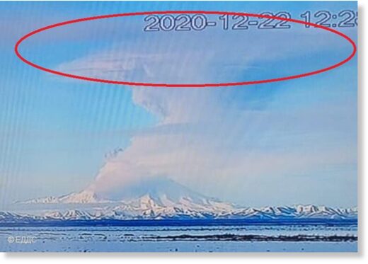
Red circle shows umbrella region formed by explosion at Sheveluch volcano today
© KVERT
Red circle shows umbrella region formed by explosion at Sheveluch volcano today

A spectacular vulcanic explosion occurred from the crater at 12:20 local time today as volcanological observatory KVERT reported.

Plume of ash rose to an altitude of 16,000 ft (4,876 m) and formed relatively large umbrella region in the upper part of the eruption column as can be seen in the image.

A few hours later, at 19:30 local time on today evening, another strong explosion detected by Volcanic Ash Advisory Center (VAAC) Tokyo produced spectacular ash plume rising up to 28,000 ft (8,500 m) altitude and extended about 130 km to the southeast of the volcano.

Incandescence in the crater visible from space
© Sentinel 2
Incandescence in the crater visible from space

Incandescence continues to be observed in the crater identified in satellite data.

The volcano's lava dome remains in a very active state.

Source: Kamchatka Volcanic Eruption Response Team volcano activity update 22 December 2020
 

TxGal

Day by day
New locust swarms form in East Africa -- Earth Changes -- Sott.net

New locust swarms form in East Africa

CGTN America
YouTube
Thu, 17 Dec 2020 16:02 UTC

East Africa locust swarm
© YouTube/CGTN America (screen capture)

In 2020, East Africa has already seen the worst locust invasion in over 70 years. Now, new swarms are forming and threatening food security on both sides of the Red Sea. See what's happening.

View: https://youtu.be/KrYkunOJ4Po
Run time is 0:56

Comment: Plagues of locusts are being reported from all around the world these days. It is likely related to increasingly erratic seasons and extreme weather patterns, which is not a consequence of 'global warming' as parroted relentlessly by the MSM: Global cooling to replace warming trend that started 4,000 years ago - Chinese scientists. See also:
 

TxGal

Day by day
The Oppenheimer Ranch Project has a new podcast out:

Christmas Blizzard + New Years Blizzard * Kilauea In-depth Update * Arctic Ice Boom *The Sun Simmers - YouTube

Christmas Blizzard + New Years Blizzard * Kilauea In-depth Update * Arctic Ice Boom *The Sun Simmers
3,665 views • Premiered 8 hours ago

View: https://youtu.be/-zgwaWMSF-E

Run time is 19:25

Synopsis provided:

Christmas blizzard in Minnesota, closing roads, stranding drivers http://strib.mn/3hcCD3A
Duluth and National Weather Service issue no-travel advisory http://bit.ly/37J1JUo
Winter weather: Blizzard conditions expected in portions of Iowa, winds could reach 50 mph http://bit.ly/34FqYFq
Florida to get coldest Christmas Eve in 2 decades http://fxn.ws/2JjRg8I
'Tis the season for 'falling iguanas' in South Florida http://cnn.it/3mQ0M0N
Winter storm brings blizzard conditions to much of U.S. https://bit.ly/3mFr1ao
SNOWFALL ANALYSIS FROM THE LAST 48 HOURS https://www.weather.gov/crh/snowfall
GFS Model Total Snow US http://bit.ly/3mLvmZF
Powerful Storm to Impact the Central and Eastern U.S. https://www.weather.gov/
Arctic Sea Ice Thickness https://bit.ly/3nLwnSF
New Kilauea Volcano Eruption Enters Third Day (Dec. 23, 2020) https://bit.ly/38zuPET
GOES X-Ray Flux http://bit.ly/30YhLGA Solar Ham https://www.solarham.net/regions/2795...
 

Carlyblue

Veteran Member
Our temps, with wind chill, are -5 today and tomorrow. We are getting just a very light dusting of snow right now. I'm glad we don't have to travel in this cold! Merry Christmas!!!
 

nomifyle

TB Fanatic
New York Man Rescued After 10 Hours In Snow-Buried Car - Ice Age Now

New York Man Rescued After 10 Hours In Snow-Buried Car
December 18, 2020 by Robert

Tioga County man’s car was buried in 4 feet (1.3 m) of snow for 10 hours.

Tioga-County-Snow-Buried-Car.png

Photo credit: New York State Police

New York State Police say 58-year-old Kevin Kresen of Candor had made several 911 calls after his car ran off the road on Route 17 near Campville.

However, even though he had made the 911 calls, no one could find him.

On Thursday, when State Police Sergeant Jason Cawley learned that no one had been able to locate Kresen’s vehicle, he joined the search on Route 17.

When Cawley saw what looked like a row of mailboxes covered in snow, he started pushing the snow away in order to find the addresses for a location. Instead, he hit a windshield of a car. Kresen was inside.

Kresen told police that he went off the road and then a plow went by, covering the car with 4 feet of snow. He was in the car with no heat for 10 hours.

Tioga County Man Rescued After 10 Hours In Snow-Buried Car

State Trooper Finds Tioga Driver Stranded in Snow for Ten Hours
What a fool this man is, living in a cold weather climate with heavy snowfall and no emergency kit to stay warm.

Our weather here in my neck of the woods in Louisiana is cold. May even have snow flurries in the next day or so, dress accordingly.

Judy
 

Windwood

Contributing Member
What a fool this man is, living in a cold weather climate with heavy snowfall and no emergency kit to stay warm.

Our weather here in my neck of the woods in Louisiana is cold. May even have snow flurries in the next day or so, dress accordingly.

Judy
Hi Judy! I'm in La too, just the hurricane ravaged SW part. We aren't expecting any snow down here but we are having gusts to 40mph and "severe clear" skies. Will be below freezing here tonight so I know all those in my forum family are having worse conditions than us. Keep warm everyone and have a very Merry Christmas!
 

TxGal

Day by day
Rare blizzard warning for Twin Cities -- Earth Changes -- Sott.net

Rare blizzard warning for Twin Cities

Guy Brown
Kare11.com
Thu, 24 Dec 2020 22:49 UTC

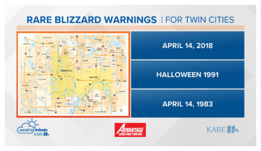
Golden Valley, Minn. — Blizzard warnings issued by the National Weather Service yesterday in the Twin Cities metro were a rare occurrence. A blizzard is when visibility is less than 1/4 of a mile for 3 hours or more, due to falling or blowing snow. White-out conditions covered the state, along with the metro.

Blizzard Warning
© KARE 11.com

The last blizzard warning that included the Twin Cities was only two years ago, April 14th, 2018. However, the one before that was the famous Halloween blizzard back in 1991. Let's look back even a little further, to another blizzard event back on April 14th 1983.

Why are blizzard warnings rare for Minneapolis and St Paul? This is due to the urban influence. Warmer temperatures are typical in cities due to the presence of lots of metal, and urban areas usually have less moisture and less vegetation.

Run time is 00:49

Yesterday's storm event broke the daily record snowfall by near two-and-a-half inches.
 

TxGal

Day by day
Blizzard for Sioux Falls - Ice Age Now

Blizzard for Sioux Falls
December 25, 2020 by Robert

The National Weather Service in Sioux Falls, South Dakota, advised people to “stay home” on Wednesday, December 23, as blizzard conditions swept through the area.

“It’s bad out there folks!” the said in a Facebook post. “Stay home and delay or cancel travel if possible!”

Video footage shows blizzard conditions outside the NWS office in Sioux Falls.

See Sioux Falls video:
View: https://www.facebook.com/watch/?v=693995841491971
Run time is 0:24

Blizzard Conditions Sweep Through Sioux Falls
 
Top