Solar Grand Solar Minimum part deux

TxGal

Day by day

snow-1960-e1597917550665.jpg


PARTS OF SOUTH AMERICA ARE FORECAST THEIR FIRST SIGNIFICANT SNOW IN 60 YEARS AS “EXCEPTIONALLY STRONG AND EXTENSIVE” ANTARCTIC AIR MASS NEARS
AUGUST 20, 2020 CAP ALLON

The Brazilian meteorology service Metsul has warned of the arrival of a “huge and very intense polar air mass” that will engulf much of the South American continent: including Uruguay, Paraguay, Bolivia, Chile, Argentina, and the southern half of Brazil.

This will be “a historical cold and snow event,” according to Metsul, who add that while cold air masses occur every year this one “will be exceptionally strong and extensive.”

GFS runs see the mercury plunging a deadly 28C below the winter average:

cold-s-America-Aug-2020.jpg

GFS 2m Temp Anomalies for Aug 21 [tropicaltidbits.com]

As reported by subrayado.com.uy, heavy snow is expected in Uruguay, near Buenos Aires and in the Argentine provinces of Santa Fe and Entre Ríos, in most of Rio Grande del Sur, Santa Catalina, Paraná, Curitiba, and the south of the state of San Paul.

In a recent article for montevideo.com, meteorologist José Serra explains that snowfall in the nation of Uruguay is an in credibly rare event.

According to Serra, August 1991 was the last decent dusting when settling flakes were recorded in the town of Cerro Colorado, Florida. However, to find the last significant accumulation of global warming goodness you have to travel back a staggering 60 years. On July 4, 1960, eastern regions of the country experienced very heavy snowfall, particularly in the department of Treinta y Tres, said Serra.

Several historical photographs remain of the occasion: for example, of a snowman made by the locals, and of a trio of women walking down a frozen main street.

Is there snow in Uruguay? — Steemit


Hay_nieve_en_Uruguay.jpg


These COLD TIMES are returning, the mid-latitudes are REFREEZING, in line with historically low solar activity, cloud-nucleating Cosmic Rays, and a meridional jet stream flow. Even NASA appear to agree, if you read between the lines, with their forecast for this upcoming solar cycle (25) seeing it as “the weakest of the past 200 years,” with the agency correlating previous solar shutdowns to prolonged periods of global cooling here.


Don’t fall for bogus, warm-mongering political agendas.

Prepare for the COLDlearn the facts, relocate if need be, and grow your own.
 

TxGal

Day by day

snow-Aus-e1597913002325.jpg


ANTARCTIC FRONT TO DELIVER “ONE-IN-15-YEAR WEATHER EVENT” TO NEW SOUTH WALES
AUGUST 20, 2020 CAP ALLON

People do the best they can with the information they have, but it appears to me, and Charles Bukowski, that the problem with the world is that the intelligent people are full of doubt, while the stupid people are full of confidence.

HEAVY SNOW is set to bury large swathes of NSW and the ACT over the next few days in what the Bureau of Meteorology is calling a “one-in-15-year weather event”, and what Electroverse posits is an addition to the ever-mounting pile of evidence which suggests anthropogenic global warming is a politicized, data-spun lie.

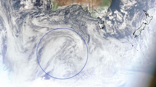
A large mass of Antarctic air is on course to blast the eastern half of Australia with blizzards, wild winds, and record-breaking low temperatures as it breaks-away from the ice continent and rides anomalously-far north on the back of a weak & wavy (meridional) jet stream (a phenomenon associated with the historically low solar activity we’re currently receiving).

https%3A%2F%2Fprod.static9.net.au%2Ffs%2F774bc30d-3ec8-480e-9d21-e8083069f2b5

‘True colour’ satellite image of the incoming polar air mass on Wednesday afternoon. (Himawari-8 satellite)


GFS 2m Temp Anomalies (C) for Sunday. Aug 23 [tropicaltidbits.com].

Over the weekend, heavy snow is forecast in Orange, Lithgow, Goulburn, Oberon, Jenolan Caves, the Blue Mountains and the high areas around Bathurst. Skiers heading to the NSW snowfields have been warned about the potential for blizzards and avalanches.

In addition to the settling snow, the BOM has said the coming front will bring the collapse of trees, branches and power lines, while black ice is likely to form on the state’s roads: “Really think twice about whether you have to go out and drive in this weather,” said SES Commissioner Carlene York.

The snow has already arrived in Perisher, with 10+cm of fresh cover accumulating on Weds, Aug 19–and there’s much more where that came from:

View: https://twitter.com/PerisherResort/status/1295888528673447937


Stay tuned for updates, including a El Niño–Southern Oscillation outlook.

The COLD TIMES are returning, the mid-latitudes are REFREEZING, in line with historically low solar activity, cloud-nucleating Cosmic Rays, and a meridional jet stream flow. Even NASA appear to agree, if you read between the lines, with their forecast for this upcoming solar cycle (25) seeing it as “the weakest of the past 200 years,” with the agency correlating previous solar shutdowns to prolonged periods of global cooling here.


Prepare accordinglylearn the facts, relocate if need be, and grow your own.
 

TxGal

Day by day

Satellite imagery shows devastation to US Midwest crops a week after derecho

Chris Michaels
WSLS 10
Mon, 17 Aug 2020 18:32 UTC

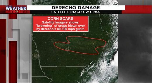
Satellite imagery shows devastation to corn, soy crop in Iowa
© University of Wisconsin's Cooperative Institute for Meteorological Satellite Studies
Satellite imagery shows devastation to corn, soy crop in Iowa

The storm leveled fields of corn, damaged agricultural buildings and had wind gusts of 80-100 mph in some places

Last Monday, a derecho (widespread windstorm) sped through parts of the upper Midwest. We first wrote about this last Tuesday, after wind gusts in parts of Iowa reached and exceeded 100 miles-per-hour. A week later, 75,000 Iowans are still without power.

The image at the top of the article shows brown scars, meaning that the blown-over crops are dying and are not coming back up. This is a devastating blow, partially because Iowa has led the U.S. in corn production for more than two decades in a row. For so many in the Midwest, this is their livelihood and with fall harvest not that far away.

Millions of acres of corn and soybeans were impacted by the storm, according to the Iowa Soybean Association. The damage is still being assessed, so it's not known exactly how much of the crop is destroyed.

View: https://youtu.be/xgrPggspGUY


Ways to help

A lot of us know what it's like to have a derecho move through, as we had one in late June of 2012. Here are a few resources to help.

Iowa Derecho Storm Resource Page Facebook group

Food pantries

If you know of any local efforts to help those dealing with the aftermath of the storm, please contact me so I can include that in this article. My information is listed here.

Comment: Powerful derecho storm wreaks havoc across US Midwest leaving 1.1 million without power
 

Martinhouse

Deceased
It was 59 degrees here when I got up this morning. North Central Arkansas.

I moved here from the Minneapolis area in June of 1977. The first ten years or so that I lived here, we had hot summers and miserable cold, snowy winters.

But in the 43 years I've lived here, it has NEVER fallen down near or below 60 degrees at night in August!

I think winter is coming, and I HATE WINTER!!!!!

Guess maybe I didn't move far enough south?
 

TxGal

Day by day
It was 59 degrees here when I got up this morning. North Central Arkansas.

I moved here from the Minneapolis area in June of 1977. The first ten years or so that I lived here, we had hot summers and miserable cold, snowy winters.

But in the 43 years I've lived here, it has NEVER fallen down near or below 60 degrees at night in August!

I think winter is coming, and I HATE WINTER!!!!!

Guess maybe I didn't move far enough south?

Wow! The night before last we got down to 62. I 'think' we were down to 65 last night, but not sure...both mornings I needed a heavier t-shirt to go do the livestock. The 62 low was tinkering with the record low for August, I believe.

Yep, this is going to be an interesting winter :-)

No...you don't want to get too close to Texas....it's been brutal the last month or so....
 

Martinhouse

Deceased
Actually, I think I'm in the right place here. I couldn't live any farther south, since I can't handle air-conditioning. I can get a sore throat just dawdling too long while shopping in a store in the summer. Everyone else would be shopping in thin dresses or shorts and tank tops, and I'd be in sweats and even a shawl at times. I used to get pneumonia in the summer when I worked in air-conditioned places.

But, still, 59 in August here is awful! I'm nowhere near ready for winter!

And I wonder if next year will be when these summer cool-downs get low enough to freeze our gardens? Do I just grow turnips and cabbage outside and do some dense planting in the greenhouse for everything else?
 

Digger

Veteran Member
We ate turnip greens and kale out of our food plot all last winter. It would get a lot of freeze damage though, but kept growing. But we had over an acre planted so there was a lot and I could just pick here and there where the greens were best. Hubby does not eat the turnip. We love the greens though. I do have some corn seed to share with you
 

Martinhouse

Deceased
Digger, thanks about the corn. I'll be going to the bank in Dover on Social Security day (Geezer Day!) Or I could meet you there next time you shop at one of our two stores there?

Actually, I can't eat greens unless they are dehydrated and powdered up so I can mix them into something like mashed potatoes or overdone rice. (I can't wear dentures and my swallower doesn't work very well any more)

I grew kale and broccoli in my attached greenhouse a couple winters ago and they were awesome! I left stumps when I harvested the leaves for dehydrating and all the stumps grew me a nice sized second harvest. I'm still using what I picked that year!

I wonder if Lowe's has bedding plants this year? I haven't been to Russellville since early March!
 

flame

Senior Member
It would be so great if our area could just get a little rain..just a little darn it! Southwest Iowa here, the lawns are dead, the dust flies, the heat continues. Hopefully the crops will be okay but geeze already.
 

TxGal

Day by day
We haven't had measurable rain in quite a while. We're under a burn ban, which is good. Pastures are just crunching....
 

summerthyme

Administrator
_______________
It was 59 degrees here when I got up this morning. North Central Arkansas.

I moved here from the Minneapolis area in June of 1977. The first ten years or so that I lived here, we had hot summers and miserable cold, snowy winters.

But in the 43 years I've lived here, it has NEVER fallen down near or below 60 degrees at night in August!

I think winter is coming, and I HATE WINTER!!!!!

Guess maybe I didn't move far enough south?
Ha! It was 41 here last night! Not unheard of, but damn... last week we were in the nineties!!

Summerthyme
 

BenIan

Veteran Member
We've been upper 90s in the day and 70s at night for several weeks with little to no rain. Have at least two tropical systems that are supposed to arrive back to back next week.

My hot weather crops are booming (field peas, long beans, okra, eggplant, amaranth, sorghum & sweet potatoes). Starting seeds for fall this weekend.
 

Grouchy Granny

Deceased
Normally, this time of year (August) we start hearing the cicadas (and yes, we do have them every year, but they are different from the eastern ones). So far - nothing!

My garden is starting to die back, don't know if that's from the excessive heat or things are just accelerating into fall already.
 

TxGal

Day by day
Adapt 2030 has a new podcast out:

View: https://www.youtube.com/watch?v=Qlas-wuFPAc


Record Long Food Lines and Summer Snow in China Again (1029)
5,464 views • Aug 20, 2020

Run time is 6:10

Following on the heals of summer snow in Beijing the last days of July, another summer snow event occurred August 18th in Yunnan Province, a month ahead of the earliest snow recorded in the area. Food Bank lines are the longest ever seen and match new reports on rental housing availability by state. Unidentifiable clouds over Alabama, do you know what it is?
 

hummer

Veteran Member
Serious question...I have never grown corn. Is any of that damaged by storm edible? Had any ripened enough for going through the laid down fields and picking? Or, could it all be ground some way for silage?
 

flame

Senior Member

(Radio Iowa) – As experts survey storm damage, estimates on wind speeds from last week’s destructive derecho continue to climb — and are now well into record territory. Rich Kinney is the warning coordination meteorologist at the National Weather Service in the Quad Cities and he’s inspected the devastation himself in communities across eastern Iowa. “The maximum estimated winds at this point are around 140 miles an hour,” Kinney says, “and that’s associated with structural damage in the Cedar Rapids area.”
Wind speeds for a major, Category Four hurricane range from 130 to 156 miles an hour — lending credence to those who’ve called this powerful storm a “prairie hurricane.” Kinney, who’s been with the weather service 23 years, says he’s never seen this type of destruction before, especially in Iowa. Cedar Rapids got the worst of it, he says. “Some apartment complexes where the entire roof was lifted off,” Kinney says. “Most of the exterior walls on the top floor were gone and a few of the interior walls as well.”
KROS-tower-225x300-225x300.jpg

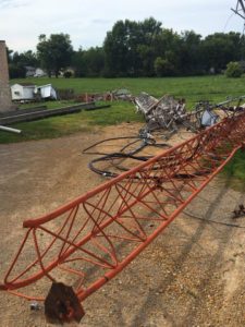
KROS radio tower blown down by the derecho.
The highest estimated winds in this storm were gusts of 126 miles an hour, recorded at a home weather station of an emergency manager in the Benton County town of Atkins. The estimated winds of 140 miles an hour that were based on the structural damage -could- be an all-time Iowa record for straight-line winds. Might they go even higher? “That is hard to say,” Kinney says, “because we’re still getting additional reports coming in daily, even ten days after the incident.”
Gusts between 120 and 140 miles an hour are now estimated in three main areas of eastern Iowa: a long stretch across Linn County which includes Cedar Rapids, and smaller patches in and around the city of Clinton and straddling both Jones and Cedar counties. With state damage estimates approaching four-billion dollars, Kinney says this will likely go down as the most powerful derecho Iowa’s ever seen, especially given the long-duration winds. “For a lot of folks, that’s what really made it seem like you were experiencing a hurricane,” Kinney says. “We had many locations with sustained, strong winds and extreme gusts for 30 to 45 minutes or so.”
A radio antenna near Van Horne that was rated to be able to withstand 125 mile per hour winds was snapped off in the storm. Another radio tower in Clinton, carrying the signal of Radio Iowa affiliate K-R-O-S, was flattened in winds Kinney estimates at 130 miles an hour.
 

txs

Contributing Member
Serious question...I have never grown corn. Is any of that damaged by storm edible? Had any ripened enough for going through the laid down fields and picking? Or, could it all be ground some way for silage?
If the kernels have dented, it just needs to dry down from that point. Either combine or chopper for silage would need to get the points under the plant to get it in the head.
 

summerthyme

Administrator
_______________
If the kernels have dented, it just needs to dry down from that point. Either combine or chopper for silage would need to get the points under the plant to get it in the head.
Which is essentially impossible.

I've harvested *leaning* corn before... a bigger PITA is hard to imagine. Plus, unless the farmer hapoens to have bunker silos and livestock to eat it (most of Iowa's corn is being grown for grain), chopping it for silage if it IS at the right stage is still pretty futile.

And it's not going to dry down well for grain on the ground... mold and mycotoxins will be a huge problem.

Summerthyme
 
Last edited:

Martinhouse

Deceased
Don't know what's done nowadays, but when I was a kid in Minnesota, silage was for dairy cows. Not sure there even were beef cattle raised anywhere near the area where I grew up.

Our dairy farmer neighbors wintered their milk cows on silage and alfalfa hay, which they produced themselves. The corn that was left in the fields to dry was used for the pigs and the poultry. Oh, and they had two teams of horses and those got the hay, too.....don't know if horses can eat silage. Maybe they bought a little grain for the horses? I'm not sure if they even had a tractor when we first lived there.
 
Last edited:

hummer

Veteran Member
Thanks for all the answers. I was just wondering. When my kids were young, and after the farmers had picked, we were given permission to " gleen" their fields. Provided my kids and I with lots of veggies and potatoes to eat during the winter. I was very much appreciative of the opportunity.
 

Cyclonemom

Veteran Member
It would be so great if our area could just get a little rain..just a little darn it! Southwest Iowa here, the lawns are dead, the dust flies, the heat continues. Hopefully the crops will be okay but geeze already.
I grew up just north of you, just a mile off highway 30. Talked to my parents a couple days ago, and mom says the ground is just dust. She was hoping to put in fall peas, but says it would be a waste of seed.
 

TxGal

Day by day
This is an important one, folks - plan accordingly!:


min-iss-e1598005412889.jpg


NEW SCIENTIFIC STUDY FINDS WE COULD BE ENTERING THE NEXT GRAND SOLAR MINIMUM
AUGUST 21, 2020 CAP ALLON

Galactic Cosmic Radiation in Interplanetary Space Through a Modern Secular Minimum” is a new paper just published in the journal Space Weather.

The paper’s abstract opens with: “Recent solar conditions indicate a persistent decline in solar activity‐‐‐possibly similar to the past solar grand minima. During such periods of low solar activity, the fluxes of galactic cosmic rays (GCRs) increase remarkably…” From here, the researchers’ primary focus is on the impact low solar activity and increasing GCRs have on interplanetary space missions (well how else would it have gotten published), however, they do leave a number of GSM truth-bombs along the way, and their conclusion is an admissible one: “GCRs are bad–and they’re only going to get worse”.

“During the next solar cycle, we could see cosmic ray dose rates increase by as much as 75%,” says lead author Fatemeh Rahmanifard of the University of New Hampshire’s Space Science Center. This spells bad news for astronauts, limiting the time they can work safely in interplanetary space (from 1000 days back in the 1990s to just 290 days for men and 204 days for women).

Why are cosmic rays growing stronger? “Blame the sun,” writes Dr Tony Phillips in his excellent article over at the always excellent spaceweather.com.

The sun’s magnetic field wraps the entire solar system in a protective bubble, normally shielding us from cosmic rays. In recent decades, however, that shield has been growing weaker–a result of the sputtering solar cycle.

Solar activity isn’t what it used to be, continues Dr Phillips. In the 1950s through 1990s, the sun routinely produced intense Solar Maxima with lots of sunspots and strong solar magnetic fields. Now look at the plot (below). Since the heyday of the late 20th century, the 11-year solar cycle has weakened, and the sun’s magnetic field has weakened with it:


The already weakening sunspot cycle took a sharp nose-dive during Solar Cycle 24. The red curve is one prediction for upcoming Solar Cycle 25. [More]

Rahmanifard and colleagues believe we could be entering a Grand Solar Minimum–a long, slow dampening of the 11-year solar cycle, which can suppress sunspot counts for decades and, as concluded by NASA, can results in a sharp cooling of the planet. The most famous example of a Grand Minimum is the Maunder Minimum of the 17th century when sunspots practically vanished for 70 years.

“We are not in a Maunder Minimum,” stresses Rahmanifard. “The current situation more closely resembles the Dalton minimum of 1790-1830 or the Gleissberg minimum of 1890-1920.” During those lesser Grand Minima, the solar cycle became weak, but didn’t completely go away.

Nevertheless, the Dalton still brought-about immense suffering and misery to the people of the time. Like the deeper Maunder and Spörer Minimums preceding it, the Dalton brought on a period of lower-than-average global temperatures. The Oberlach Station in Germany, for example, experienced a 2C decline over 20 years, which devastated the country’s food production.

The Year Without a Summer also occurred during the Dalton Minimum, in 1816. It was caused by a combination of already low temperatures plus the aftereffects of the second largest volcanic eruption in 2000 years: Mount Tambora’s VEI 7 on April 10, 1815 (for more on the link between reduced solar activity, cosmic rays and volcanic/seismic upticks click here).
One Virginia resident recalled, “In June another snowfall came and folks went sleighing. On July 4, 1816 water froze in cisterns and snow fell again, with Independence Day celebrants moving inside churches where hearth fires warmed things a mite.”

Clothes froze on the line in New England, ice on ponds and lakes was reported in northwestern Pennsylvania in both July and August, and Virginia had frosts in August. The temperature occasionally got into the 90s, but then would drop to nearly freezing in just a few hours.

Crops that had managed to sprout were frozen out in early June, replanted, and frozen again in July. Very few crops were actually harvested, and of those that were, the yields were very poor. In turn, food and grain prices skyrocketed — for example, in 1815, oats sold for $0.12 a bushel but by the next year, a bushel would set you back $0.92.

And the story was similar across the world — for more:


In the below plots, Rahmanifard et al compare the Dalton and Gleissberg minima (top panels) to recent solar cycles (bottom panels).

grandminima.png

SC5 compared with SC24 (left), SC12 compared with SC24 (right). Then two predictions for SC25 if the past Minima was to play out identically.

For years, researchers have been monitoring cosmic rays using CRaTER, a sensor orbiting the Moon on board NASA’s Lunar Reconnaissance Orbiter (LRO). Recent data show that cosmic rays are at very high levels–the highest since LRO was launched in 2009. (See Figure 1 in their paper.)

“We took the latest readings from CRaTER and extrapolated them forward into Solar Cycle 25 (the next solar cycle),” says Rahmanifard. “We found that radiation doses will probably exceed already-high values by 34% for a Gleissberg-like minimum to 75% for a Dalton-like minimum.”

Rahmanifard’s paper may primarily focus on the ramifications low solar activity has on interplanetary space missions, but what it also forewarns is that this solar shutdown will extend through solar cycle 25 (at least), and as we know thanks to historical documentation, the 400-year sunspot record, and research at NASA: what that likely means is a return of the COLD TIMES. Exactly how cold (how low we sink) will be determined by the progression of solar cycle 25. Most indicators point to it being substantially lower than even the historically weak solar cycle 24 (just gone)… but only time will tell.

Stay tuned for updates.

The mid-latitudes appear to be REFREEZING in line with historically low solar activity, cloud-nucleating Cosmic Rays, and a meridional jet stream flow.

NASA have said this upcoming solar cycle (25) will be “the weakest of the past 200 years,” and the agency have correlated previous solar shutdowns to prolonged periods of global cooling here.


Don’t fall for bogus, warm-mongering political agendas.

Prepare for the upcoming solar-driven chilllearn the facts, relocate if need be, and grow your own.
 

Martinhouse

Deceased
TxGal, you're sure right that we'd need to plan accordingly for this. Nice to know I have a good strong greenhouse now and it will be getting even better sometime in the next month or so. And I can organize it lots better than it is right now, and be able to grow nearly twice what I've been growing. The new frame is strong enough that I could attach hanging shelves all around and grow many things in smaller pots on those shelves. Plus I could set in narrow rows of pots between the rows of large containers and then also hang things above those, too.

I still have a 24' x 24' piece of greenhouse plastic tarp that I could use over a short tunnel made of five or six arched cattle panels. This would extend growing season in another outdoor location for as long as the tarp held up., and would possibly be enough to protect against those sudden summer freezes that are mentioned in the article.

My brain spins like crazy when I run into this sort of thing. I even come up with some workable ideas now and then!
 

TxGal

Day by day
TxGal, you're sure right that we'd need to plan accordingly for this. Nice to know I have a good strong greenhouse now and it will be getting even better sometime in the next month or so. And I can organize it lots better than it is right now, and be able to grow nearly twice what I've been growing. The new frame is strong enough that I could attach hanging shelves all around and grow many things in smaller pots on those shelves. Plus I could set in narrow rows of pots between the rows of large containers and then also hang things above those, too.

I still have a 24' x 24' piece of greenhouse plastic tarp that I could use over a short tunnel made of five or six arched cattle panels. This would extend growing season in another outdoor location for as long as the tarp held up., and would possibly be enough to protect against those sudden summer freezes that are mentioned in the article.

My brain spins like crazy when I run into this sort of thing. I even come up with some workable ideas now and then!

I have to admit I didn't expect to see that stunning of a news piece on a Friday morning....wow. I'm going to review our planning later today.

You are doing really, really great! You should be proud of what you've done, that is darn hard work - especially for us senior folks!

DH picked one of the best watermelons we've ever grown last evening, I think it's a rattlesnake variety, weighed in at 25lbs! And it's a darn good thing he picked it, because raccoons came in overnight and decimated the rest. Fortunately they were smaller melons, and most were destined for the chickens, but dang. We do have a electric fence set-up that we've never used, next gardening season we're putting it up. I may try to get another one, preferably solar (just in case).

Today is a shopping day for me, we're watching TD #14 that's heading for us and is forecasted to be a Cat 1 at US landfall. Not a monster, and heaven knows we need rain...but I'd be happy with just a few 'regular' days of rain.
 

Sammy55

Veteran Member
I can speculate that the decreasing daylight that has started the winter coat growth on the cattle....maybe so the seemingly early congregating ducks. I honestly don't know. Kinda makes me want to start loading winter hay up.

I don't think it's totally related to the decreasing daylight as I'm sure there's just as much daylight around this time every year. There's an extra factor someplace that causes animals and plants to start getting ready for winter weeks earlier than normal. Like this year....

I would believe the animals and plants over what the weathermen say. So if the "animals" tell you to get your winter hay in, then do it. JMHO

We don't have animals to get in feed for, unfortunately, but we're getting as ready as fast as we can for an early winter. We're in northeastern Minnesota, so for us, a bad winter is definitely something to prepare for!!
 

TxGal

Day by day

snow-aussie-e1598085628928.jpg


HUGE SNOWFALLS ACROSS EASTERN AUSTRALIA AS ANTARCTIC AIR TAKES CHARGE
AUGUST 22, 2020 CAP ALLON

Ski areas in Australia have logged more than 60cm (2 feet) of snowfall over the past few days, while rare settling flakes have also been reported in many low-lying regions.

According to inthesnow.com, “a super storm has been dumping on the country’s ski slopes since Wednesday, with increasing intensity in terms of the amount of snow falling every 24 hours.”

Residents in Katoomba, Blackheath, and Mount Victoria have experienced significant snowfall with street, parks, and homes buried under a blanket of white; while dozens of additional towns and cities have also reported healthy, and at times rare, accumulations:

View: https://twitter.com/StormchaserUKEU/status/1297059122232385538


View: https://twitter.com/nampix/status/1296959755924078593


View: https://twitter.com/darylread/status/1296977390833250356


View: https://twitter.com/Lauren_Southern/status/1297037988531249152


It comes as temperatures plummet 12C below the seasonal average across large parts of Australia, as a brutal Antarctic air mass blasts the country’s east.

Goulburn, north of Canberra, may not see the mercury reach double digits until next week. While Canberra itself is on for its coldest day in at least four years, and has already witnessed a few flurries of global warming goodness.

“The Antarctic air will continue to spread over southeastern Australia between now and Sunday,” Weatherzone meteorologist Ben Domensino said. Snowfall is forecast to surpass a metre (3.3 feet) before the weekend is out, and “a few places may even witness rare thundersnow,” added Domensino.

Alarmists, enjoy.

Oh, and looking forward: a potentially monster system (putting this one to shame) is currently on course to batter the ENTIRE Aussie continent as the calendar flips to September. The forecast is within the unreliable time-frame, and so needs to be taken with a grain of salt, but it certainly warrants close attention; a polar blast as powerful and wide-reaching as this one could rewrite the record books.

Stay tuned for updates.

gfs_T2ma_aus_54.png

GFS 2m Temp Anomalies (C) for Sept 4 [tropicaltidbits.com]

The COLD TIMES are returning, the mid-latitudes are REFREEZING, in line with historically low solar activity, cloud-nucleating Cosmic Rays, and a meridional jet stream flow. Even NASA appear to agree, if you read between the lines, with their forecast for this upcoming solar cycle (25) seeing it as “the weakest of the past 200 years,” with the agency correlating previous solar shutdowns to prolonged periods of global cooling here.


Prepare for the COLDlearn the facts, relocate if need be, and grow your own.
 

TxGal

Day by day

13 waterspouts seen over The Great Lakes

Anja Kundacina
Narcity
Tue, 18 Aug 2020 18:37 UTC

waterspout
© The Weather Network | Rumble

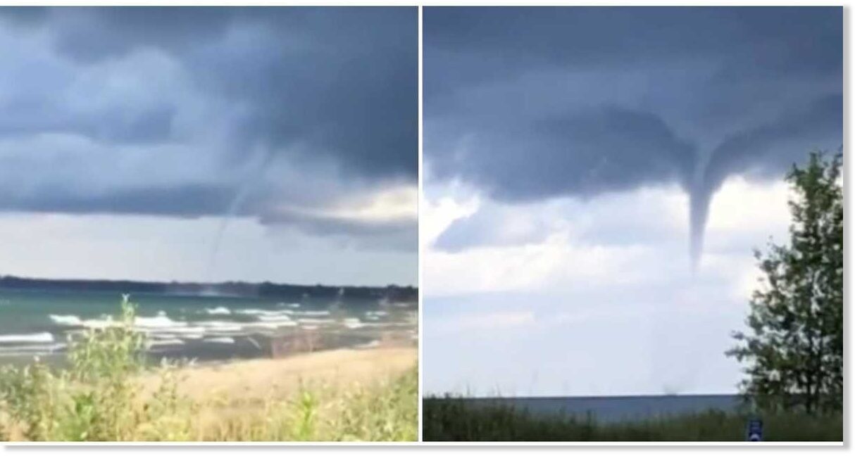
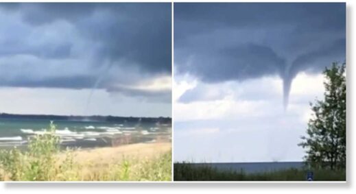
Weather in 2020 keeps making headlines. Huge water tornadoes were spotted all over Ontario lakes on Monday. Footage of the surreal Great Lakes waterspouts are being shared online and more are expected to show up this week.

According to the International Centre for Waterspout Research (ICWR), there were 13 sightings of water funnels throughout the Great Lakes region on Monday.

"We have confirmed a total of 13 waterspouts that formed over parts of the Great Lakes on Monday, August 17. Expect more on Tuesday," says a post from ICWR.

View: https://youtu.be/x7LwpocpXpQ


View: https://youtu.be/NK65v9wn5Og


More of these weather phenomenons are expected to be on the way this Tuesday as well as on Wednesday, so keep a lookout if you're in the area.

According to their most recent update, the high waterspout activity should ease up into the afternoon on Tuesday, before reemerging again in the morning.

It's predicted that areas on the eastern shores of Lake Ontario and those on the southern shores of Georgian Bay will get the most activity.

"Waterspouts will redevelop early Wednesday morning, especially over Eastern Lake Ontario and Southern Georgian Bay," it says.

There have already been tons of waterspouts recorded throughout the month of August after an outbreak was reported. It looks like this trend is continuing.

Comment:
Record outbreak of 84 waterspouts last week over the Great Lakes

Unreal footage from eastern Lake Ontario shows just how huge and ominous these spouts can get.

View: https://youtu.be/j2lkNM02ylc


A giant waterspout was even spotted on Lake Huron at Sauble Beach in Ontario.

"Cooler temperatures aloft, combined with warm lake temperatures, have created an unstable atmosphere conducive for waterspout formation," said TWN meteorologist Kelly Sonnenburg.

View: https://twitter.com/rUv/status/1295105926496747523
 

TxGal

Day by day

Multiple waterspouts filmed swirling at once in Gulf of Mexic

fox29.com
Fri, 21 Aug 2020 18:19 UTC

waterspout
Multiple waterspouts were spotted swirling simultaneously off Louisiana's coast on August 20, as severe storms battered the region with hail.

This footage shot by Frank Leday in the Gulf of Mexico captures at least six of the watery vortexes spiraling skyward against a blanket of dark storm clouds.

"Wow!! Ever see 6 water spouts at once?" Leday wrote on Facebook.

The storms came as the US National Weather Service predicted two tropical depressions — one in the North Atlantic and another in the Carribean — could develop into hurricanes upon hitting the Gulf. According to US media, it would be the first instance of two separate tropical storm systems in the basin in over 60 years.

(There is a video here I can't bring over - please go to the link to see it)

View: https://youtu.be/U1nrDrh2uKA


View: https://twitter.com/StormchaserUKEU/status/1296718309593882624


View: https://twitter.com/ZackFradellaWx/status/1296548900363526145


View: https://twitter.com/StormchaserUKEU/status/1296538567779520516
 

TxGal

Day by day

'Extremely rare': Two hurricanes could be in the Gulf of Mexico next week

Nicholas Reimann
Forbes
Thu, 20 Aug 2020 15:09 UTC

hurricane
© Getty
File photo: Tropical storm

The historically active 2020 Atlantic hurricane season continues to ramp up, with the National Hurricane Center identifying two tropical depressions, both of which could strengthen as they head toward the Gulf of Mexico and the U.S. coastline.

KEY FACTS

The National Hurricane Center projects Tropical Depression Thirteen, over the central Atlantic, and Tropical Depression Fourteen, in the western Caribbean, will strengthen from their 35 mph sustained winds as they move toward the U.S.

There's still a great deal of uncertainty about how strong the storms could become, but it seems very likely they will become the 12th and 13th named storms — Laura and Marco — over the next day or so.

Tropical Depression Thirteen is forecast to become a Category 1 hurricane as it moves past the Bahamas and approaches south Florida on Monday, before potentially entering the eastern Gulf of Mexico.

Over the next 36 hours, Tropical Depression Fourteen will be entering an area where "environmental conditions appear ideal for strengthening," according to the National Hurricane Center, before it's expected to make landfall along Mexico's Yucatan peninsula and then reemerge in the Gulf of Mexico, heading northward toward the U.S. coastline.

As of now, the National Hurricane Center keeps the system as a strong tropical storm in the Gulf of Mexico, but acknowledged "there is greater-than-normal uncertainty" in its future intensity.

SURPRISING FACT

Both storms are forecast to be in the northern Gulf of Mexico on Tuesday, which is an extremely rare phenomenon. "I can't say I have ever seen two storms trying to share the Gulf at the same time," Zack Fradella, a New Orleans-based meteorologist, said Thursday.

Comment: Similarly, it's unusual to see 10 waterspouts emerge from the same storm, as seen in Louisiana yesterday:


CRITICAL QUOTE

"It is too soon to know exactly how strong it will get or the location and magnitude of impacts it will produce along the central or northwestern Gulf Coast," the National Hurricane Center said for Tropical Depression Fourteen, while saying of Tropical Depression Thirteen that, "The details and long-range track and intensity forecasts are more uncertain than usual."

WHAT TO WATCH FOR

A Hurricane Hunter aircraft is scheduled to investigate Tropical Depression Fourteen in the Caribbean Thursday afternoon, which will collect more data on the system that could improve forecasting confidence.

TANGENT

Florida Gov. Ron DeSantis (R) warned Thursday that Tropical Depression Thirteen could impact Florida, saying, "Floridians should take time now to prepare 7 days of supplies."

KEY BACKGROUND

In terms of named storms, the 2020 Atlantic hurricane season has gotten off to the fastest start in history, according to record-keeping dating back to 1851. But storms so far haven't been very strong — only Hanna and Isaias have become hurricanes, and both were Category 1 status. Forecasters are predicting much stronger storms over the remainder of the season, with several storms reaching Category 3 or higher, a potentially devastating strength if they make landfall with that intensity.
 

Martinhouse

Deceased
There's a new Adapt 2030 video just up. rt = 13:52 min.

"You Are Being Trained for Food Shortages"

It shows him tramping around his new property in eastern Tennessee.
 

TxGal

Day by day
There's a new Adapt 2030 video just up. rt = 13:52 min.

"You Are Being Trained for Food Shortages"

It shows him tramping around his new property in eastern Tennessee.

Thanks, Martinhouse, been outside taking care of the critters.

----------------------------------------------------------------------------------------------------------------

Here's the new Adapt 2030 podcast:

View: https://www.youtube.com/watch?v=ZLv_zdAFewA


You Are Being Trained for Food Shortages (1021)
2,952 views • Aug 22, 2020

Run time is 13:52

China now admits there is a food crisis and the same week the US agricultural department begins to buy surplus crops from farmers to stock food banks. Cosmic rays are increasing to levels not measured since the Dalton Minimum in 1810. ADAPT 2030 begins a homestead in East Tennessee.
 

TxGal

Day by day

Cold and frost, weather warning in Namibia
August 22, 2020 by Robert

“Farmers in particular are called upon to take the necessary precautionary measures.”

Cold and frost, weather warning in Namibia.

Warnung vor Frost und Kälte - Wetter - Allgemeine Zeitung

George Herald

Thanks to Argiris Diamantis and David Hartley for these links

“I watch a live stream from a waterhole in Africa,” says David.” Just by chance I caught a comment that a poster had just had a message about snow in Namibia. Caught the sense it was rare but not unknown.”
 

TxGal

Day by day

70 percent chance of La Niña forming, says weather agency
August 22, 2020 by Robert

And rare thundersnow in Australia

The weather agency Weatherzone updated its El Niño–Southern Oscillation (ENSO) outlook saying there is a 70 per cent chance of La Niña forming before the end of 2020.

La Niña brings colder waters and causes sharp shifts in on-land weather conditions.

The last significant stretch of La Niña in Australia occurred between December 2010 and March 2011 and resulted in the country’s wettest two-year period on record.

Meanwhile, Antarctic air will continue to spread over south eastern Australia between now and Sunday, causing a wintry mix of wind, rain, hail and snow in multiple states,” Weatherzone meteorologist Ben Domensino said. “A few places may even witness rare thundersnow (lightning and snow at the same time).”

Hobart, Melbourne, Canberra, Sydney and Adelaide are all forecast to see drops in minimum temperatures into the single figures beginning tomorrow.

Rare lightning snow storm headed for Australia
 

TxGal

Day by day

Temperature drops below freezing in Russia
August 22, 2020 by Robert

Frost in Moscow region … Even though it’s still summer.

In the morning of August 21, in the east of the Moscow region, in Cherusty, in the grass, the air temperature dropped to -1 degrees. These are the first frosts of the upcoming season .

In the Kostroma region, frosts in the grass stand up to -1 degrees are observed for the third day in a row.

Новости погоды

Новости погоды
 

TxGal

Day by day

Midsummer Blizzard in China – Video
August 21, 2020 by Robert

Also a fifth wave of flooding reaching three stories high.

In Gansu Province, the floods reached three stories high, and the wooden homes of many villagers collapsed. The province is among the hardest hit by the floods along the Yangtze River, which is already seeing a fifth wave of the floods, despite the fourth wave still not being over.

View: https://youtu.be/FiFDlGaxwqc
 

TxGal

Day by day

Snow forecast for Montana, British Columbia and Alberta
August 21, 2020 by Robert

“It’s a forecast, 10 days out. It will change over that time period, but it’s not forecasting nice golfing weather in the 80s. It says snow in August.”

32″ snow forecast for North central B C, Canada:
https://www.windy.com/-Show—add-more-layers/overlays?snowAccu,57.988,-124.365,8,m:fixacHj

14.6″ snow forecast for NW of Jasper, Alberta Canada:
https://www.windy.com/-Show—add-more-layers/overlays?snowAccu,53.278,-118.597,8,m:e8sacQZ

2″ snow forecast for Montana:
https://www.windy.com/-Show—add-more-layers/overlays?snowAccu,45.543,-111.927,11,m:eU4ac2w
 
Top