
You are using an out of date browser. It may not display this or other websites correctly.
You should upgrade or use an alternative browser.
You should upgrade or use an alternative browser.
Solar Grand Solar Minimum part deux
- Thread starter Dennis Olson
- Start date
-
- Tags
- grand solar minimum

alpha
Veteran Member
Electroverse

Extreme Weather
Moscow has been copping heavy snow of late, too.
It has been snowing constantly in the capital since Sunday.
As a result, accumulations have built to 22 cm (8.7 inches) — one of the highest levels on record for the time of year, and one that approaches the highest totals (for mid-Dec) in books dating back to the 1800s: the 33 cm (13 inches) from 1919 (the Centennial Minimum).
More snow is in the forecast.
Russian weather site hmn.ru says there’s a chance Moscow will rival that historic benchmark: “Southern cyclones attack the central regions of Russia with maniacal persistence,” reads the opening line of an article dated Dec 16.
“Moscow barely has time to clear itself of one snowfall, as the next whirlwind is on its way,” continues hmr.ru. “The most intense snowfall will take place in Moscow on Saturday afternoon and Sunday night … By Monday, Dec 19, the snow depth at VDNH may exceed 30 cm, which will be a record for this day!”
Moscow’s official weather station (VDNKh) has received 28+cm (11 inches) by Dec 19 on just two separate occasion: 1985 and 1993 (both around solar minimums).

Daily Snow Extent for Dec 15 [Rutgers GSL].
Over the past 30-hours, Ust-Kamenogorsk, the administrative center of Eastern Kazakhstan, has been buried under a record-breaking amount of snow, with totals topping 1-meter (3.3-ft)
The conditions hit so fast that utility services were unable to clear the city’s streets.
Business, schools and public transportation were closed, reports Astana TV, bringing the city to a standstill.
More than 200 utility workers are now rushing to reopen Ust-Kamenogorsk, but it’s hard going:
“Snowfall is a thing of the past”
Also, the national temperature data is in for November 2022 in Kazakhstan.
The month was colder-than-average, according to the official books, with the chill most notable in the Northeast of the country where monthly anomalies of as much as -2.6C below the multidecadal norm were logged.
Long-standing low temperature records continue to fall across the Aussie continent –particularly across the East (see links below)— with rare and heavy summer snow also clipping the higher elevations.
Most recently, the Bureau of Meteorology (BoM) confirmed that Holbart, Tasmania suffered through the state’s coldest December day since 1964 (solar minimum of cycle 19) on Thursday, with thermometers struggling to a high of just 11.5C (52.7F).
“We’re in a south to south-easterly airstream that’s pulling up some really cold air from south of the state, and we just can’t seem to get rid of it,” said senior meteorologist Brooke Oakley.
A low solar activity-induced ‘meridional’ jet stream flow is delivering Australia its coldest start to summer on record — and the anomalous polar chill isn’t done with the continent just yet:

GFS 2m Temperature Anomalies (C) Dec 16 [tropicaltidbits.com].

GFS 2m Temperature Anomalies (C) Dec 17 [tropicaltidbits.com].

GFS 2m Temperature Anomalies (C) Dec 23 [tropicaltidbits.com].

GFS 2m Temperature Anomalies (C) Dec 30 [tropicaltidbits.com].
The UK has suffered lows nearing -20C (-4F) this week — among the coldest December readings ever recorded in Britain in weather books dating back to the 1800s.
The Met Office isn’t calling for an end to the inclement conditions, rather an escalation, over the weekend.
The forecaster has escalated its snow/ice warnings from yellow to amber, and has also urged people, particularly Scots, to brace for power outages, issues with phone coverage, and the possibility of rural communities becoming cut off.
The Met Office is also warning of high winds, which will likely lead to blizzard conditions.
A foot of accumulating snow is possible over the highest elevations — incredibly rare for mid-December.
For more on the UK’s record-breaking and long-lasting freeze, see the relevant sections in the links below:

Daily UK Weather_
@XtremeUKWeather
This is beautiful Mother Nature at it finest #uksnow https://t.co/C8kG2k0mXB

5:52 PM · Dec 11, 2022
European Gas Prices Soar
The extended cold outbreak will impact more than just the UK; much of the Europe is also in the firing-line, with the freezing forecast once again driving-up the continent’s energy prices.
European natural gas prices advanced by as much as 3.3% in recent trading, with particularly frigid temps set to befall the Nordics and Central/Western nations, according to forecaster Maxar.
China placing large LNG orders isn’t helping the situation, intensifying competition.
I also question if China even needs these reserves.
The country has indeed struggled in past winters to handle increasing heating demand, but it must be understood that the climate crisis, or more specifically the limiting of nations’ access to cheap and reliable energy (via CO2 restrictions), is a form of modern warfare.
The West is severely hamstringing itself with absurd, illogical climate policies; an infiltrated UN, its MSM lapdogs, and the blind/corrupt activists/TV-pop-scientists are determinedly gunning for an end to the prosperity and high living standards that we’ve come to enjoy over the past 50-or-so years.
It stands that a strong Europe, i.e. one with access to cheap energy, isn’t necessarily good for the Chinese, nor is it all-that beneficial for the U.S., for that matter (hence the destruction of the Nord Stream–with the aid of the UK…?).
Meteorologists are warning that this is currently shaping up to be the most extreme cold air mass to impact the U.S. during the month of December in decades, no doubt sparking interesting Christmas dinner debates up and down the country with the younger generations that have been brainwashed into accepting Orwellian Doublethink, i.e. that ‘warming = cooling’.
The truly fierce, likely benchmark-busting Arctic Outbreak, which will first affect western Canada early next week before diving into the Plains, Central U.S. and East, is the product of several weather phenomena.
Firstly, that unprecedented ‘blocking high’ over Greenland is finally impacting North America; secondly, there is an extreme alignment of weather systems over the North Atlantic, which also favors extreme cold in both Europe and North America; and thirdly, an area of high pressure across eastern Siberia and Alaska is also working to funnel polar cold deep into the US.
Such cross-polar winds are a hallmark of extreme cold outbreaks, and, as discussed above, are more prevalent under times of low solar activity, such as the historically low output we’re receiving now.
The astonishing freeze has been building in Siberia of late, with a record -61C (-77.8F) logged this week.
Judah Cohen, head of seasonal forecasting at AER, said the coming setup will be the second such extreme freeze event in recent times, rivaling the freeze in February 2021 during which the Texas grid failed, killing 702 people.
This will also be one of the coldest in the month of December for decades.
“The overall setup for this event is classic for major cold air outbreaks across much of central North America,” Jason Furtado, a University of Oklahoma meteorologist said, adding that the unusual cold may extend into 2023, too.

GFS 2m Temperature Anomalies (C) Dec 16 – Dec 26 [tropicaltidbits.com].

GFS Total Snowfall (inches) Dec 16 – Jan 1 [tropicaltidbits.com].
At the close, natural gas for January delivery was up 54 cents, or 8.4%, to settle at $6.97.
The jump was assisted by a report from the Energy Information Administration (EIA) that revealed utilities pulled 50 billion cubic feet (bcf) from storage last week. That was more than double the previous week’s draw, and during a comparatively mild period, too –far colder conditions on the way next week, which are expected to pull far more gas from storage.
Still, this weeks conditions, although comparatively mild, still proved record-breaking for many.
A major snowstorm delivered 4 feet and blizzard conditions to the northern Plains, leaving thousands without power, hundreds stranded on roadways and a number of cold-benchmarks slain.
In Alta, Utah, 47 inches of snow was measured as of Wednesday morning, with surrounding mountains receiving similar totals. In fact, impressive accumulations have been observed across Utah, Nebraska, the Dakotas, Minnesota and Michigan.
In Duluth, MN — for example– the heavy snow bands over the course of three hours resulted in the storm officially becoming a blizzard on Wednesday morning. While in Bismark, ND, records were felled — the 10.4 inches that settled Tuesday set a record for the date, topping the previous mark of 5.9 inches from 2008 (solar min of cycle 23) — with more expected into the weekend.
The future looks cold…
…prepare.
Extreme Weather
Snow Continues To Build In Moscow; 1-Meter (3.3-Ft) Buries Kazakhstan City In 30-Hours; Tasmania’s Coldest December Day In 50-Years; UK Met Office Escalates Snow/Ice Warnings; + America’s Historic Arctic Blast Draws Nearer
December 16, 2022 Cap AllonSnow Continue To Build In Moscow
It’s been exceptionally cold and snowy across the majority of transcontinental Russia over the past 6-or-so weeks, with 90+% of the nation’s land mass blanketed in snow since late-October (Rutgers GSL).Moscow has been copping heavy snow of late, too.
It has been snowing constantly in the capital since Sunday.
As a result, accumulations have built to 22 cm (8.7 inches) — one of the highest levels on record for the time of year, and one that approaches the highest totals (for mid-Dec) in books dating back to the 1800s: the 33 cm (13 inches) from 1919 (the Centennial Minimum).
More snow is in the forecast.
Russian weather site hmn.ru says there’s a chance Moscow will rival that historic benchmark: “Southern cyclones attack the central regions of Russia with maniacal persistence,” reads the opening line of an article dated Dec 16.
“Moscow barely has time to clear itself of one snowfall, as the next whirlwind is on its way,” continues hmr.ru. “The most intense snowfall will take place in Moscow on Saturday afternoon and Sunday night … By Monday, Dec 19, the snow depth at VDNH may exceed 30 cm, which will be a record for this day!”
Moscow’s official weather station (VDNKh) has received 28+cm (11 inches) by Dec 19 on just two separate occasion: 1985 and 1993 (both around solar minimums).
Daily Snow Extent for Dec 15 [Rutgers GSL].
1-Meter (3.3-Ft) Buries Kazakhstan City In 30-Hours
Over the past 30-hours, Ust-Kamenogorsk, the administrative center of Eastern Kazakhstan, has been buried under a record-breaking amount of snow, with totals topping 1-meter (3.3-ft)The conditions hit so fast that utility services were unable to clear the city’s streets.
Business, schools and public transportation were closed, reports Astana TV, bringing the city to a standstill.
More than 200 utility workers are now rushing to reopen Ust-Kamenogorsk, but it’s hard going:
“Snowfall is a thing of the past”
Also, the national temperature data is in for November 2022 in Kazakhstan.
The month was colder-than-average, according to the official books, with the chill most notable in the Northeast of the country where monthly anomalies of as much as -2.6C below the multidecadal norm were logged.
Tasmania’s Coldest December Day In 50-Years
Long-standing low temperature records continue to fall across the Aussie continent –particularly across the East (see links below)— with rare and heavy summer snow also clipping the higher elevations.Most recently, the Bureau of Meteorology (BoM) confirmed that Holbart, Tasmania suffered through the state’s coldest December day since 1964 (solar minimum of cycle 19) on Thursday, with thermometers struggling to a high of just 11.5C (52.7F).
“We’re in a south to south-easterly airstream that’s pulling up some really cold air from south of the state, and we just can’t seem to get rid of it,” said senior meteorologist Brooke Oakley.
A low solar activity-induced ‘meridional’ jet stream flow is delivering Australia its coldest start to summer on record — and the anomalous polar chill isn’t done with the continent just yet:

GFS 2m Temperature Anomalies (C) Dec 16 [tropicaltidbits.com].

GFS 2m Temperature Anomalies (C) Dec 17 [tropicaltidbits.com].

GFS 2m Temperature Anomalies (C) Dec 23 [tropicaltidbits.com].

GFS 2m Temperature Anomalies (C) Dec 30 [tropicaltidbits.com].
UK Met Office Escalates Snow/Ice Warnings
The UK has suffered lows nearing -20C (-4F) this week — among the coldest December readings ever recorded in Britain in weather books dating back to the 1800s.The Met Office isn’t calling for an end to the inclement conditions, rather an escalation, over the weekend.
The forecaster has escalated its snow/ice warnings from yellow to amber, and has also urged people, particularly Scots, to brace for power outages, issues with phone coverage, and the possibility of rural communities becoming cut off.
The Met Office is also warning of high winds, which will likely lead to blizzard conditions.
A foot of accumulating snow is possible over the highest elevations — incredibly rare for mid-December.
For more on the UK’s record-breaking and long-lasting freeze, see the relevant sections in the links below:
Daily UK Weather_
@XtremeUKWeather
This is beautiful Mother Nature at it finest
#uksnow https://t.co/C8kG2k0mXB
5:52 PM · Dec 11, 2022
European Gas Prices Soar
The extended cold outbreak will impact more than just the UK; much of the Europe is also in the firing-line, with the freezing forecast once again driving-up the continent’s energy prices.
European natural gas prices advanced by as much as 3.3% in recent trading, with particularly frigid temps set to befall the Nordics and Central/Western nations, according to forecaster Maxar.
China placing large LNG orders isn’t helping the situation, intensifying competition.
I also question if China even needs these reserves.
The country has indeed struggled in past winters to handle increasing heating demand, but it must be understood that the climate crisis, or more specifically the limiting of nations’ access to cheap and reliable energy (via CO2 restrictions), is a form of modern warfare.
The West is severely hamstringing itself with absurd, illogical climate policies; an infiltrated UN, its MSM lapdogs, and the blind/corrupt activists/TV-pop-scientists are determinedly gunning for an end to the prosperity and high living standards that we’ve come to enjoy over the past 50-or-so years.
It stands that a strong Europe, i.e. one with access to cheap energy, isn’t necessarily good for the Chinese, nor is it all-that beneficial for the U.S., for that matter (hence the destruction of the Nord Stream–with the aid of the UK…?).
America’s Historic Arctic Outbreak Draws Nearer
A blast of Arctic air straight from the Arctic is poised to entomb North America over the festive period, shattering records and potentially spinning up major wintry storms.Meteorologists are warning that this is currently shaping up to be the most extreme cold air mass to impact the U.S. during the month of December in decades, no doubt sparking interesting Christmas dinner debates up and down the country with the younger generations that have been brainwashed into accepting Orwellian Doublethink, i.e. that ‘warming = cooling’.
The truly fierce, likely benchmark-busting Arctic Outbreak, which will first affect western Canada early next week before diving into the Plains, Central U.S. and East, is the product of several weather phenomena.
Firstly, that unprecedented ‘blocking high’ over Greenland is finally impacting North America; secondly, there is an extreme alignment of weather systems over the North Atlantic, which also favors extreme cold in both Europe and North America; and thirdly, an area of high pressure across eastern Siberia and Alaska is also working to funnel polar cold deep into the US.
Such cross-polar winds are a hallmark of extreme cold outbreaks, and, as discussed above, are more prevalent under times of low solar activity, such as the historically low output we’re receiving now.
The astonishing freeze has been building in Siberia of late, with a record -61C (-77.8F) logged this week.
Judah Cohen, head of seasonal forecasting at AER, said the coming setup will be the second such extreme freeze event in recent times, rivaling the freeze in February 2021 during which the Texas grid failed, killing 702 people.
This will also be one of the coldest in the month of December for decades.
“The overall setup for this event is classic for major cold air outbreaks across much of central North America,” Jason Furtado, a University of Oklahoma meteorologist said, adding that the unusual cold may extend into 2023, too.

GFS 2m Temperature Anomalies (C) Dec 16 – Dec 26 [tropicaltidbits.com].

GFS Total Snowfall (inches) Dec 16 – Jan 1 [tropicaltidbits.com].
U.S. NatGas Prices Rally
As in Europe, North America’s cold outbreak, which market analysts are concerned could compare to those of 1977, 1982, 1985 and 1989, saw NatGas jump 8% Thursday.At the close, natural gas for January delivery was up 54 cents, or 8.4%, to settle at $6.97.
The jump was assisted by a report from the Energy Information Administration (EIA) that revealed utilities pulled 50 billion cubic feet (bcf) from storage last week. That was more than double the previous week’s draw, and during a comparatively mild period, too –far colder conditions on the way next week, which are expected to pull far more gas from storage.
Still, this weeks conditions, although comparatively mild, still proved record-breaking for many.
A major snowstorm delivered 4 feet and blizzard conditions to the northern Plains, leaving thousands without power, hundreds stranded on roadways and a number of cold-benchmarks slain.
In Alta, Utah, 47 inches of snow was measured as of Wednesday morning, with surrounding mountains receiving similar totals. In fact, impressive accumulations have been observed across Utah, Nebraska, the Dakotas, Minnesota and Michigan.
In Duluth, MN — for example– the heavy snow bands over the course of three hours resulted in the storm officially becoming a blizzard on Wednesday morning. While in Bismark, ND, records were felled — the 10.4 inches that settled Tuesday set a record for the date, topping the previous mark of 5.9 inches from 2008 (solar min of cycle 23) — with more expected into the weekend.
The future looks cold…
…prepare.
northern watch
TB Fanatic

Martinhouse
Deceased
Right now my overnight lows for the 22nd and 23rd are predicted to be 4F and 13F. They keep changing the numbers, but the last couple of days the changes have all been downward. The daytime high for the 23rd is 21F and I don't think that's ever happened before in the 45+ years that I've lived here. NW central Arkansas.
TxGal
Day by day
Oh my gosh, Martinhouse! Our low on the 22nd is forecasted to be 16 and on the 23rd it's 22. We're not going to get above freezing on the 23rd. They keep changing our long range forecast, too...downward.
We've got our hay supply in and our feed, but I sure don't look forward to getting out there and taking care of the animals. I'm just hoping the power stays on, there's no precipitation, and no strong winds from the north...sunshine would be nice. Ha!
I really hate winter!
We've got our hay supply in and our feed, but I sure don't look forward to getting out there and taking care of the animals. I'm just hoping the power stays on, there's no precipitation, and no strong winds from the north...sunshine would be nice. Ha!
I really hate winter!
Martinhouse
Deceased
TxGal, yeah, my house is very small and there is no basement or garage. So I built 8 ft. porches across both front and back and they are like warehouses, as is the interior of the house. I'm VERY worried about the things stored in the back porch. It's where I store a lot of canned and bottled goods, plus my potato harvest and any squash, cabbages, etc., I might have gathered. It is on the east side so a little less subject to the icy north and west winds that the front porch gets. Only dry goods are stored in the front (west) porch.
All I can think to do is stay up all night and run my space heater out in the back porch. If the power goes out, I'll have to wear a headlamp and carry as much important stuff as possible into the house itself, and hope it won't get quite down ro freezing in here. (I would not care to run more than one space heater at a time, so I'll just have to accept that I'll probably lose all my flowers out in the attached greenhouse. Hoping to have enough time and strength to harvest most of the greens before they could freeze.)
I can keep myself close to warm enough by heating a big pot of water on my camp stove and sitting over it under a blanket. My health has degraded faster than I expected and I was never able to get the living room reorganized enough for it to be safe to use my wood stove. Not sure what I'll do about that.
Guess I'll find a way.
Or I won't.
I HATE WINTER!!!!!
Last edited:
Martinhouse
Deceased
I just said that I hate winter. Too bad most of what I'm reading lately is saying that for a while now we might be having very short and hot summers along with some very LONG and BRUTALLY COLD winters.
UGH!
UGH!
Martinhouse
Deceased
I just discovered that my ten day forecast has changed to overnight low temps for the 22nd, 23rd, and 24th to 2F, 11F, and 17F.
Not sure I know what to do about this. I'm fairly well fixed to cope with no electricity, but not at temps that low!
Not sure I know what to do about this. I'm fairly well fixed to cope with no electricity, but not at temps that low!
TxGal
Day by day
Oh my gosh! Now we're forecasted for 13, 19, and 24, with atleast one day not over 32. Yours is far worse.I just discovered that my ten day forecast has changed to overnight low temps for the 22nd, 23rd, and 24th to 2F, 11F, and 17F.
Not sure I know what to do about this. I'm fairly well fixed to cope with no electricity, but not at temps that low!
TxGal
Day by day
Oh my gosh...without another source of heat in case the power goes out, you could be in a serious spot. I don't know if you could find a Buddy heater and even just the small 1lb canisters, but that would help. Generally WalMart and Ace Hardware carry them, but with that weather heading for you they may be sold out.TxGal, yeah, my house is very small and there is no basement or garage. So I built 8 ft. porches across both front and back and they are like warehouses, as is the interior of the house. I'm VERY worried about the things stored in the back porch. It's where I store a lot of canned and bottled goods, plus my potato harvest and any squash, cabbages, etc., I might have gathered. It is on the east side so a little less subject to the icy north and west winds that the front porch gets. Only dry goods are stored in the front (west) porch.
All I can think to do is stay up all night and run my space heater out in the back porch. If the power goes out, I'll have to wear a headlamp and carry as much important stuff as possible into the house itself, and hope it won't get quite down ro freezing in here. (I would not care to run more than one space heater at a time, so I'll just have to accept that I'll probably lose all my flowers out in the attached greenhouse. Hoping to have enough time and strength to harvest most of the greens before they could freeze.)
I can keep myself close to warm enough by heating a big pot of water on my camp stove and sitting over it under a blanket. My health has degraded faster than I expected and I was never able to get the living room reorganized enough for it to be safe to use my wood stove. Not sure what I'll do about that.
Guess I'll find a way.
Or I won't.
I HATE WINTER!!!!!
Maybe your nephew can swing by and help with the woodstove.
Martinhouse
Deceased
Just checked the forecast again and now it's saying the lows for the 22nd, 23rd, and 24th will be 0F, 8F, and 16F. The daytime high for the 23rd is 17F.
EEK!
EEK!
Martinhouse now they are starting to talk about more snow on Thursday than they originally thought too. We will see how it looks later in the week. We might have to deliver presents early and have our family dinner later.
The winter of 83-84 was brutal in Arkansas. The Arkansas river at Van Buren froze over. We had ice and snow on the roads for 2 weeks or more. I remember it because my son was a baby and I broke my ankle.
The winter of 83-84 was brutal in Arkansas. The Arkansas river at Van Buren froze over. We had ice and snow on the roads for 2 weeks or more. I remember it because my son was a baby and I broke my ankle.
northern watch
TB Fanatic


Martinhouse
Deceased
Just got on the computer this morning and found I'd forgotten to send this post:
TxGal, nephew said he had an extra heater he could bring me if the power goes out. He lives only about half a mile up the road from me.
Digger, I remember one winter back then that we got 17 inches of snow and my water lines froze. Power did not go out and I was constantly melting that snow in my electric skillet. There was myself and two teenage girls, a dog and two cats. If that was 1983-84, I think I had chickens then, too.
Last edited:
alpha
Veteran Member
Electroverse
Part 1

Extreme Weather
Low temperature benchmarks are falling across North and South Korea, Taiwan, Hong Kong, and Vietnam, to name just five, with -28C (-18.4F), -19C (-2.2F), -4C (24.8F)–at sea level, 5C (41F) and 0C (32F) logged, respectively.
The Hong Kong Observatory issued both a ‘frost warning’ and a ‘cold weather alert’ on Sunday. While Taiwan’s -4C (24.8F), registered at Emei, was a nationwide record low for a non-mountain area, according to the Central Weather Bureau.
Sea level frosts have been suffered in China, a nation which has suffered historic cold in recent weeks.
While in Japan, the mercury in Hokkaido has plunged to -24.3C (-11.7F), with widespread frosts sweeping the likes of Honshu. Miyama, Kyoto observed -6.6C (20.1F) on Monday, the locale’s lowest December temperature on record (tying with 1980).

December 19 lows (JMA)
Japan’s freezing lows are being accompanied by heavy snows.
“Jaw-dropping” totals battered swatches of the country through Monday.
Over just a 24-hour period, a whopping 231 cm (7.6 ft) buried Niigata Prefecture, 193 cm (6.3 ft) fell in Amori, 170 cm (5.6 ft) in Niigata, 154cm (5 ft) in Hokkaido with 148cm (4.9 ft) accumulating in Fukushima — all much heavier than originally forecast.

Maimunka News
@MaimunkaNews
 In #Japan, due to heavy snow, more than 18 thousand people were left without electricity and heat. The height of snow cover by noon in a number of areas of Yamagata prefecture is 229 cm, in Aomori - 193 cm, Niigata - 170 cm, Hokkaido - 154 cm, Fukushima - 148 cm #Winter https://t.co/dHW4SmKZFF https://t.co/KRKtwCLUc2

3:54 AM · Dec 19, 2022
https://twitter.com/intent/like?ref...6037widget=Tweet&tweet_id=1604762164534956037

道の駅 漢学の里しただ
@shitada289
本日、豪雪の為 臨時休館とさせていただきます。 お客様にはご迷惑おかけいたしますが、ご理解頂けますようお願い申し上げます。 https://t.co/B1oxmCJ4T7

8:33 PM · Dec 18, 2022
A host of all-time records have been broken, including in Tadmi, Nagaoka and Kaneyama, and also a December-record, in Hijiori:

Sayaka Mori
@sayakasofiamori
#Snow has been piling up at an unprecedented pace in Japan. In Tadami, 110cm accumulated in 24 hours, making it the all-time record. Hijiori has now 231cm on the ground, renewing a record for December. Check out the video below. It's jaw-dropping https://t.co/Zx2azLyUFq https://t.co/pJNK8rNuBj

3:28 AM · Dec 19, 2022
This relentless snow adds to the record-busting monthly totals suffered last week:
Sayaka Mori
@sayakasofiamori
Record-smashing heavy #snow has been pounding N. Japan's Yamagata prefecture. In 48 hours, Hijiori had 134cm, surpassing the previous December record of 107cm. Shinjo had 89cm, making it the all-time record and 390% of normal Shinkansen bullet trains are still running https://t.co/PDTeOR8Elu

5:37 AM · Dec 16, 2022
More snow is on the way.
Freezing temperatures are also driving into the Tropics.
Stay tuned for updates.
continued...
Part 1
Extreme Weather
Cold Wave Grips East Asia, Felling All-Time Snowfall Records Across Japan; Historic Snow In Moscow; + Christmas Freeze: Extreme Cold/Snow To Blast North America Over The Holidays
December 19, 2022 Cap AllonCold Wave Grips East Asia…
A fierce cold wave engulfing the majority East Asia is busy felling long-standing records.Low temperature benchmarks are falling across North and South Korea, Taiwan, Hong Kong, and Vietnam, to name just five, with -28C (-18.4F), -19C (-2.2F), -4C (24.8F)–at sea level, 5C (41F) and 0C (32F) logged, respectively.
The Hong Kong Observatory issued both a ‘frost warning’ and a ‘cold weather alert’ on Sunday. While Taiwan’s -4C (24.8F), registered at Emei, was a nationwide record low for a non-mountain area, according to the Central Weather Bureau.
Sea level frosts have been suffered in China, a nation which has suffered historic cold in recent weeks.
While in Japan, the mercury in Hokkaido has plunged to -24.3C (-11.7F), with widespread frosts sweeping the likes of Honshu. Miyama, Kyoto observed -6.6C (20.1F) on Monday, the locale’s lowest December temperature on record (tying with 1980).

December 19 lows (JMA)
…Felling All-Time Snowfall Records Across Japan
Japan’s freezing lows are being accompanied by heavy snows.“Jaw-dropping” totals battered swatches of the country through Monday.
Over just a 24-hour period, a whopping 231 cm (7.6 ft) buried Niigata Prefecture, 193 cm (6.3 ft) fell in Amori, 170 cm (5.6 ft) in Niigata, 154cm (5 ft) in Hokkaido with 148cm (4.9 ft) accumulating in Fukushima — all much heavier than originally forecast.
Maimunka News
@MaimunkaNews
In #Japan, due to heavy snow, more than 18 thousand people were left without electricity and heat. The height of snow cover by noon in a number of areas of Yamagata prefecture is 229 cm, in Aomori - 193 cm, Niigata - 170 cm, Hokkaido - 154 cm, Fukushima - 148 cm #Winter https://t.co/dHW4SmKZFF https://t.co/KRKtwCLUc2
3:54 AM · Dec 19, 2022
https://twitter.com/intent/like?ref...6037widget=Tweet&tweet_id=1604762164534956037
道の駅 漢学の里しただ
@shitada289
本日、豪雪の為 臨時休館とさせていただきます。 お客様にはご迷惑おかけいたしますが、ご理解頂けますようお願い申し上げます。 https://t.co/B1oxmCJ4T7
8:33 PM · Dec 18, 2022
A host of all-time records have been broken, including in Tadmi, Nagaoka and Kaneyama, and also a December-record, in Hijiori:
Sayaka Mori
@sayakasofiamori
#Snow has been piling up at an unprecedented pace in Japan. In Tadami, 110cm accumulated in 24 hours, making it the all-time record. Hijiori has now 231cm on the ground, renewing a record for December. Check out the video below. It's jaw-dropping https://t.co/Zx2azLyUFq https://t.co/pJNK8rNuBj
3:28 AM · Dec 19, 2022
This relentless snow adds to the record-busting monthly totals suffered last week:
Sayaka Mori
@sayakasofiamori
Record-smashing heavy #snow has been pounding N. Japan's Yamagata prefecture. In 48 hours, Hijiori had 134cm, surpassing the previous December record of 107cm. Shinjo had 89cm, making it the all-time record and 390% of normal
Shinkansen bullet trains are still running https://t.co/PDTeOR8Elu
5:37 AM · Dec 16, 2022
More snow is on the way.
Freezing temperatures are also driving into the Tropics.
Stay tuned for updates.
continued...
alpha
Veteran Member
Electroverse
Part 2
Parts of Moscow have seen snow pile up over a foot high, something not usually observed until the end of February, according to the Fobos weather center; the previous years such mid-Dec depths were reached were back in 1989 and 1993.
Some 119,000 workers and over 12,500 vehicles were deployed to clear the snow, according to Moscow city authorities, as an intense single-day snowstorm event not seen in decades –as far back as 80 years according to some reports– gripped the city.
“It’s a snow Armageddon: in Moscow … you can’t walk or drive,” state-controlled Channel One said in a report.

LX
@LXSummer1
Moscow, Ruzzia An emergency weather warning has been issued in Moscow - a snowfall hit the capital, which has not been seen for more than 80 years. There is so much snow on the roads that cars get stuck and people are dropped off public transport to walk. https://t.co/oU5yFrmlNJ

4:08 AM · Dec 18, 2022
https://twitter.com/intent/like?ref...8209widget=Tweet&tweet_id=1604403108913758209

Siraj Noorani
@sirajnoorani
Record snowdrifts have grown in Moscow - from 33 to 38 centimeters, Phobos (Russia's weather investigation center) told #Sputnik #Moscow #Russia #snow https://t.co/OtPMOjxvvE

4:21 AM · Dec 18, 2022
Sidewalks were left completely covered in snow with snow-clearing equipment prioritizing roads to ease the heavily congested traffic. Air traffic was also impacted, with many flights either delayed or cancelled across Moscow airports.
There is even a Winter Storm Warning for Hawaii, with 14 inches of snow forecast on Mauna Loa and Mauna Kea.
The intensity will be reminiscent of the February 2021 event that stressed energy grids, most notably in Texas where multiday power grid failure resulted in the deaths of at least 702 people.
‘Winter’ is already gripping practically all of North America–barring Southern Florida, and the cold is getting extreme, too. The Yukon, Canada –for example– plunged to -47C (-52F) on Sunday, at Pelly Ranch; while -34C (-29F) was logged at Peter Sinks, UT.
‘Falling iguanas for Christmas’ will be the story in Florida later in the week, as the churning mass of Arctic air deep into the Sunshine State, delivering December frosts to not only the Panhandle but also parts of Central Florida, possibly even Orlando itself.

GFS 2m Temperature Anomalies (C) Dec 23 – Dec 27 [tropicaltidbits.com].
Looking elsewhere, the Dakotas should brace for a dangerously cold and snowy festive period.
Bismarck is already on pace to set a winter snowfall record.
The city’s official snow total from the most-recent storm was 20.3 inches. The 10.4 inches that fell on Tuesday alone set a city record for the date, with the moisture in the snow breaking a benchmark that had stood more than a century.
The capital city added 3 inches on Wednesday, 4.1 inches on Thursday and 2.8 inches on Friday. This makes it 46.5 inches of snow since the onset of fall, which is three times more than normal and already, according to NWS data, a new record for Oct 1 – Dec 31, besting the 45.8 inches from 2008 (solar minimum of cycle 23) with additional inches expected this week.
The cold will also be challenging, and will last throughout the holiday.
Daily highs in Bismarck are forecast to hold below zero (F) Monday through Friday, with overnight lows reaching the -20s (-29C to -35C) late in the workweek, with the wind chill plunging into the -30s (-35C to -40C).
Temperatures that low can freeze exposed skin in a matter of minutes.

GFS 2m Temperature Anomalies (C) Dec 18 – Dec 25 [tropicaltidbits.com].
The polar air arrives as an earlier storm system in the NE gradually winds down after burying parts of the region under two feet of snow. More than 80,000 customers in New England were still without power as of Sunday morning.
The next polar front will bring “extreme and prolonged freezing conditions”, the NWS said in a special weather statement Sunday.
The federal Weather Prediction Center has warned of a “massive expanse of frigid temperatures from the Northern Rockies/Northern Plains to the Midwest through the middle of the week, and then reaching the Gulf Coast and much of the Eastern U.S. by Friday and into the weekend.”
By Thursday night, temperatures will plunge as low as -10.6C (13F) in Jackson, Mississippi; and around -15C (5F) in Nashville, Tennessee; while up north, in Montana, life threatening wind chills of -45.6C (-50F) are possible — not a typo.

GFS 2m Temperature Anomalies (C) Dec 22 [tropicaltidbits.com].
The COLD TIMES are returning, North America, in line with historically low solar activity.

GFS 2m Temperature Anomalies (C) Dec 18 – Dec 25 [tropicaltidbits.com].

GFS Total Snowfall (inches) Dec 19 – Jan 4 [tropicaltidbits.com].
Prepare.
Part 2
Historic Snow In Moscow
Following the impressive dumpings of the past seven days, more heavy snow descended on the Russian capital on Sunday, disrupting traffic, delaying flights and leaving sidewalks buried.Parts of Moscow have seen snow pile up over a foot high, something not usually observed until the end of February, according to the Fobos weather center; the previous years such mid-Dec depths were reached were back in 1989 and 1993.
Some 119,000 workers and over 12,500 vehicles were deployed to clear the snow, according to Moscow city authorities, as an intense single-day snowstorm event not seen in decades –as far back as 80 years according to some reports– gripped the city.
“It’s a snow Armageddon: in Moscow … you can’t walk or drive,” state-controlled Channel One said in a report.
LX
@LXSummer1
Moscow, Ruzzia
An emergency weather warning has been issued in Moscow - a snowfall hit the capital, which has not been seen for more than 80 years. There is so much snow on the roads that cars get stuck and people are dropped off public transport to walk. https://t.co/oU5yFrmlNJ
4:08 AM · Dec 18, 2022
https://twitter.com/intent/like?ref...8209widget=Tweet&tweet_id=1604403108913758209
Siraj Noorani
@sirajnoorani
Record snowdrifts have grown in Moscow - from 33 to 38 centimeters, Phobos (Russia's weather investigation center) told #Sputnik #Moscow #Russia #snow https://t.co/OtPMOjxvvE
4:21 AM · Dec 18, 2022
Sidewalks were left completely covered in snow with snow-clearing equipment prioritizing roads to ease the heavily congested traffic. Air traffic was also impacted, with many flights either delayed or cancelled across Moscow airports.
Christmas Freeze: Extreme Cold/Snow To Blast North America Over The Holidays
An extreme Arctic blast is on course punish hundreds-of-millions of Americans this week, from Washington to Florida, with record-low temperatures for many and a dangerous blizzard readying to hammer the Great Lakes (again).There is even a Winter Storm Warning for Hawaii, with 14 inches of snow forecast on Mauna Loa and Mauna Kea.
The intensity will be reminiscent of the February 2021 event that stressed energy grids, most notably in Texas where multiday power grid failure resulted in the deaths of at least 702 people.
‘Winter’ is already gripping practically all of North America–barring Southern Florida, and the cold is getting extreme, too. The Yukon, Canada –for example– plunged to -47C (-52F) on Sunday, at Pelly Ranch; while -34C (-29F) was logged at Peter Sinks, UT.
‘Falling iguanas for Christmas’ will be the story in Florida later in the week, as the churning mass of Arctic air deep into the Sunshine State, delivering December frosts to not only the Panhandle but also parts of Central Florida, possibly even Orlando itself.

GFS 2m Temperature Anomalies (C) Dec 23 – Dec 27 [tropicaltidbits.com].
Looking elsewhere, the Dakotas should brace for a dangerously cold and snowy festive period.
Bismarck is already on pace to set a winter snowfall record.
The city’s official snow total from the most-recent storm was 20.3 inches. The 10.4 inches that fell on Tuesday alone set a city record for the date, with the moisture in the snow breaking a benchmark that had stood more than a century.
The capital city added 3 inches on Wednesday, 4.1 inches on Thursday and 2.8 inches on Friday. This makes it 46.5 inches of snow since the onset of fall, which is three times more than normal and already, according to NWS data, a new record for Oct 1 – Dec 31, besting the 45.8 inches from 2008 (solar minimum of cycle 23) with additional inches expected this week.
The cold will also be challenging, and will last throughout the holiday.
Daily highs in Bismarck are forecast to hold below zero (F) Monday through Friday, with overnight lows reaching the -20s (-29C to -35C) late in the workweek, with the wind chill plunging into the -30s (-35C to -40C).
Temperatures that low can freeze exposed skin in a matter of minutes.

GFS 2m Temperature Anomalies (C) Dec 18 – Dec 25 [tropicaltidbits.com].
The polar air arrives as an earlier storm system in the NE gradually winds down after burying parts of the region under two feet of snow. More than 80,000 customers in New England were still without power as of Sunday morning.
The next polar front will bring “extreme and prolonged freezing conditions”, the NWS said in a special weather statement Sunday.
The federal Weather Prediction Center has warned of a “massive expanse of frigid temperatures from the Northern Rockies/Northern Plains to the Midwest through the middle of the week, and then reaching the Gulf Coast and much of the Eastern U.S. by Friday and into the weekend.”
By Thursday night, temperatures will plunge as low as -10.6C (13F) in Jackson, Mississippi; and around -15C (5F) in Nashville, Tennessee; while up north, in Montana, life threatening wind chills of -45.6C (-50F) are possible — not a typo.

GFS 2m Temperature Anomalies (C) Dec 22 [tropicaltidbits.com].
The COLD TIMES are returning, North America, in line with historically low solar activity.

GFS 2m Temperature Anomalies (C) Dec 18 – Dec 25 [tropicaltidbits.com].

GFS Total Snowfall (inches) Dec 19 – Jan 4 [tropicaltidbits.com].
Prepare.
northern watch
TB Fanatic
Yukon wind chill below -50 C, more snow for southern B.C., as frigid system hits
This report by The Canadian Press was first published Dec. 19, 2022.VANCOUVER — Weather alerts blanket most of British Columbia, Yukon and a large portion of Alberta as a bitterly cold system sweeps across those regions and another round of snow threatens southern B.C.

Yukon wind chill below -50 C, more snow for southern B.C., as frigid system hits© Provided by The Canadian Press
Environment Canada says the unseasonably cold temperatures will bring wind chill values in parts of B.C. and Alberta to near or below — 40 C, while it could feel as cold as -54 C overnight in northern Yukon.
The weather office predicts frigid conditions are expected to last for much of the week.
Southern B.C., is still recovering from a Sunday snowfall that dumped anywhere from five to 30 centimetres across the Lower Mainland, leaving many key roads and bridges slick and ice covered.
Additional snowfall warnings now blanket Vancouver Island, the inner south coast including Metro Vancouver and southern Okanagan.
A further 10 to 15 centimetres is expected by early Tuesday, with even more forecast for mountain passes east of Vancouver and on the Malahat Highway north of Victoria.
The Canadian Press
MSN
www.msn.com
northern watch
TB Fanatic


northern watch
TB Fanatic

northern watch
TB Fanatic
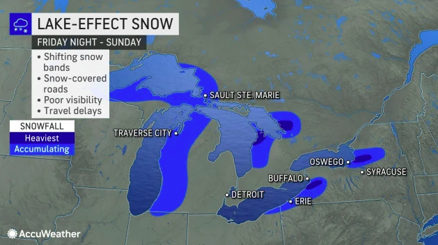
Widespread outbreak of Arctic air to send temperatures plummeting across US
By Renee Duff, AccuWeather meteorologistPublished Dec. 17, 2022 12:32 AM EST | Updated Dec. 19, 2022 1:58 PM EST


alpha
Veteran Member
Electroverse

Extreme Weather
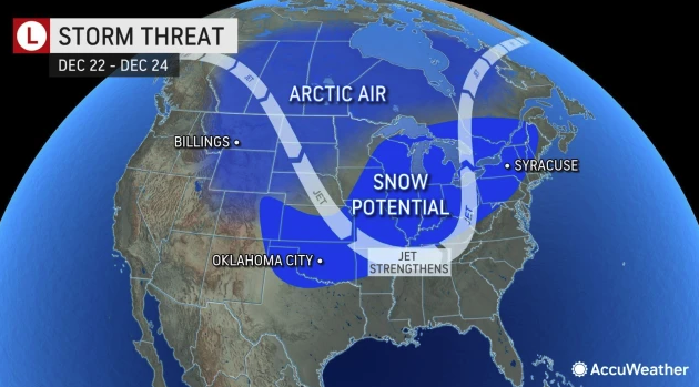
The storms are set to explosively develop in the Midwest and Great Lakes later this week, potentially qualifying as a “bomb cyclone” because of its projected rapid strengthening — and will unleash heavy snow and strong winds, as well as bitter, record-setting low temperatures.
The freeze is already impacting some northern and eastern provinces/states.
The lowest reading in Canada yesterday, Dec 19, was the -50C (-58F) suffered at Rabbit Kettle, Northwest Territories; while in the U.S., the temperature bottomed-out at -31F (-35C) in Northgate, North Dakota.
Extreme cold has been impacting British Columbia, too: -46.8C was logged in Puntzi Mountain, the province’s coldest December temp since 1996 (solar minimum of cycle 22). Staying in B.C., -42.2C was registered at Clinton & Dease Lake, -41C at Muncho Lake, -40.8C in Fort Nelson, -37.5C Quesnel, -37.4C at Tatlayoko Lake, -36.9C at Burns Lake, and -36.8C in Prince George.
Headed back below the border, the city of Chicago, for example, is currently on for one of its coldest Christmas day on record.
This week first threatens to deliver a powerful snowstorm, but after that a period of bitter cold will dominate, with daily maximum temperatures dropping into the single-digits and wind chills plunging well-below zero over the festive weekend.
Chicago’s coldest Christmas on record took place in 1983, when the daily high at O’Hare International Airport held at just -5F degrees, with the second-coldest occurring two years later in 1985 (solar minimum of cycle 21), when thermometers struggled to just 2F — these benchmarks are in reach this Christmas, which is a testament to the ferocity of this incoming Arctic Outbreak.
Chicago is all-but assured a top-5 coldest Christmas on record, dating back to at least 1871.

GFS 2m Temperature Anomalies (C) Dec 20 to Dec 23 [tropicaltidbits.com]

GFS 2m Temperature Anomalies (C) Dec 24 to Dec 27 [tropicaltidbits.com].
To the 17th, this December is on course to be the UK’s ninth coldest in books dating back to 1659.
This is another inconvenience for the AGW Party, another they could have done without, and it’s also a major headache for authorities and the National Grid given the country’s concerning –and self-inflicted– energy situation.
The Central England Temperature (CET) is the longest running weather dataset in the world. It’s reading is just 0.4C as of Dec 17, which is a whopping -4.2C below the old 1961-1990 average that the Met Office insists on using (a historically cool era).
To put that 0.4C into perspective, out of the 363 years the dataset has been running, this December is running as the ninth coldest, bested only by the Decembers of 1981, 1784, 1874, 1878, 1796, 1788, 1676, 2010, and 1890.
Note that the year 2010, with its December average of -0.7C, finished as the second-coldest December in the CET’s 363-year history; another inconvenience I’m sure the AGW Party will want swept under the rug.
The UK is due a slight warm-up over the Holidays, barring a fleeting Christmas eve/day blast, but Arctic air looks set to make an explosive return soon after, to ring in the New Year:

UK forecast to refreeze from Dec 31 to (at least) Jan 5 [tropicaltidbits.com].
The heavy snow is also on course to make a comeback:

GFS Total Snowfall (inches) Dec 20 to Jan 5 [tropicaltidbits.com].
Prepare.
All-time record-breaking snow is continuing across Japan, particularly the Sea of Japan coast where 1000+ vehicles have been stranded overnight on highways, train services have been disrupted, and widespread power outages have been the theme.
With drivers stuck and shivering on two national highways, Niigata Prefecture requested a disaster-relief dispatch of the Self-Defense Forces to help resolve the traffic congestion in Kashiwazaki as well as other cities.
However, local authorities have said there is currently no prospect of improving the situation on other, smaller sections of the highway and surrounding roads, with traffic jams also occurring on the highway serving Nagaoka and Ojiya.

A transport ministry video feed showed vehicles stuck in a traffic jam on a national highway in Nagaoka, on Tues.
At least 1000 cars and trucks were stuck in Kashiwazaki at around 1 AM Tuesday, with work continuing throughout the night, according to the authorities. Food, warm drinks and blankets were distributed to those stuck overnight in the heavy snow.
One driver complained that after being stranded for more than 15 hours, her car had only moved 50m (164ft).
As reported on yesterday (link below), all-time snowfall records have been slain across Japan this week.

طقس_العالم ️
️
@Arab_Storms
#اليابان تضرر الناس في مقاطعتي فوكوشيما ونيغاتا من تساقط قياسي للثلوج ويستعدون لمزيد من سوء الأحوال الجوية في اليوم المقبل. 19-12-2022 #Japan #snow https://t.co/Gc2lXPdPYp

11:12 AM · Dec 19, 2022
https://twitter.com/intent/like?ref...4369widget=Tweet&tweet_id=1604872378143674369
Sayaka Mori
@sayakasofiamori
#Snow has been piling up at an unprecedented pace in Japan. In Tadami, 110cm accumulated in 24 hours, making it the all-time record. Hijiori has now 231cm on the ground, renewing a record for December. Check out the video below. It's jaw-dropping https://t.co/Zx2azLyUFq https://t.co/pJNK8rNuBj
3:28 AM · Dec 19, 2022
Cold Wave Grips East Asia, Felling All-Time Snowfall Records Across Japan; Historic Snow In Moscow; + Christmas Freeze: Extreme Cold/Snow To Blast North America Over The Holidays
Those who tell us that our world is heating uncontrollably are, knowingly or not, pushing a Marxist agenda.
This is why the ‘Climate Crisis’ ruse needs taking down.
This is why I report on instances of historic cold/snow across the likes of North America, Europe, Asia and Australia; it is why I point to the unprecedented growth on Greenland; to Arctic ice holding-up incredibly well in recent years; to a cooling Antarctica; and to the fact that since 2016 the global average temperature has been falling, and is expected to continue to fall in line with historically low solar activity.
Wake others up to the fraud–or at least attempt to, for this is a battle for the freedom of humanity and for truth, not merely for the accurate reporting of the state of the climate.
I couldn’t care less if someone believes the planet is warming, ALL theories should be on the table, as is right and proper. What’s sinister here, though, is the obvious and ever-desperate censorial efforts of the powers-that-be, namely through their gas-lighting MSM lapdogs and obfuscating, paid-off pop-scientists.
Their dirty de-platforming agenda –of real climate scientists!– in order to silence debate is another red flag. If ‘Catastrophic Anthropogenic Global Warming’ was indeed a real and genuine thing it wouldn’t need such a powerful and expensive marketing campaign to promote it; it would –most-certainly by now, 40+ years into the hypothesis!– be obvious to us all.
TPTB can’t trust The Free Marketplace Of Ideas with this one; instead, ‘the boot’ is required.
Once you understand the corruption and purist of evils that permeate the deepest runnings of our world, this line of thinking isn’t in anyway a leap of imagination, nor is it a crazy conspiracy theory; rather, it is a mere connection of the dots.
Extreme Weather
“Blockbuster” Cold Strikes North America; UK On For Its 9th Coldest December In 363-Years Of Record-Keeping; + Japan’s Unprecedented Snow Continues, Strands Drivers
December 20, 2022 Cap Allon“Blockbuster” Cold Strikes North America
Christmas 2022 is on course to be the coldest on record for many, as two disruptive and dangerous weather systems sweep large portions of Canada and the Lower 48.The storms are set to explosively develop in the Midwest and Great Lakes later this week, potentially qualifying as a “bomb cyclone” because of its projected rapid strengthening — and will unleash heavy snow and strong winds, as well as bitter, record-setting low temperatures.
The freeze is already impacting some northern and eastern provinces/states.
The lowest reading in Canada yesterday, Dec 19, was the -50C (-58F) suffered at Rabbit Kettle, Northwest Territories; while in the U.S., the temperature bottomed-out at -31F (-35C) in Northgate, North Dakota.
Extreme cold has been impacting British Columbia, too: -46.8C was logged in Puntzi Mountain, the province’s coldest December temp since 1996 (solar minimum of cycle 22). Staying in B.C., -42.2C was registered at Clinton & Dease Lake, -41C at Muncho Lake, -40.8C in Fort Nelson, -37.5C Quesnel, -37.4C at Tatlayoko Lake, -36.9C at Burns Lake, and -36.8C in Prince George.
Headed back below the border, the city of Chicago, for example, is currently on for one of its coldest Christmas day on record.
This week first threatens to deliver a powerful snowstorm, but after that a period of bitter cold will dominate, with daily maximum temperatures dropping into the single-digits and wind chills plunging well-below zero over the festive weekend.
Chicago’s coldest Christmas on record took place in 1983, when the daily high at O’Hare International Airport held at just -5F degrees, with the second-coldest occurring two years later in 1985 (solar minimum of cycle 21), when thermometers struggled to just 2F — these benchmarks are in reach this Christmas, which is a testament to the ferocity of this incoming Arctic Outbreak.
Chicago is all-but assured a top-5 coldest Christmas on record, dating back to at least 1871.

GFS 2m Temperature Anomalies (C) Dec 20 to Dec 23 [tropicaltidbits.com]

GFS 2m Temperature Anomalies (C) Dec 24 to Dec 27 [tropicaltidbits.com].
UK On For 9th Coldest December In 363-Years Of Record-Keeping
To the 17th, this December is on course to be the UK’s ninth coldest in books dating back to 1659.This is another inconvenience for the AGW Party, another they could have done without, and it’s also a major headache for authorities and the National Grid given the country’s concerning –and self-inflicted– energy situation.
The Central England Temperature (CET) is the longest running weather dataset in the world. It’s reading is just 0.4C as of Dec 17, which is a whopping -4.2C below the old 1961-1990 average that the Met Office insists on using (a historically cool era).
To put that 0.4C into perspective, out of the 363 years the dataset has been running, this December is running as the ninth coldest, bested only by the Decembers of 1981, 1784, 1874, 1878, 1796, 1788, 1676, 2010, and 1890.
Note that the year 2010, with its December average of -0.7C, finished as the second-coldest December in the CET’s 363-year history; another inconvenience I’m sure the AGW Party will want swept under the rug.
The UK is due a slight warm-up over the Holidays, barring a fleeting Christmas eve/day blast, but Arctic air looks set to make an explosive return soon after, to ring in the New Year:

UK forecast to refreeze from Dec 31 to (at least) Jan 5 [tropicaltidbits.com].
The heavy snow is also on course to make a comeback:

GFS Total Snowfall (inches) Dec 20 to Jan 5 [tropicaltidbits.com].
Prepare.
Japan’s Unprecedented Snow Continues, Strands Drivers
All-time record-breaking snow is continuing across Japan, particularly the Sea of Japan coast where 1000+ vehicles have been stranded overnight on highways, train services have been disrupted, and widespread power outages have been the theme.With drivers stuck and shivering on two national highways, Niigata Prefecture requested a disaster-relief dispatch of the Self-Defense Forces to help resolve the traffic congestion in Kashiwazaki as well as other cities.
However, local authorities have said there is currently no prospect of improving the situation on other, smaller sections of the highway and surrounding roads, with traffic jams also occurring on the highway serving Nagaoka and Ojiya.

A transport ministry video feed showed vehicles stuck in a traffic jam on a national highway in Nagaoka, on Tues.
At least 1000 cars and trucks were stuck in Kashiwazaki at around 1 AM Tuesday, with work continuing throughout the night, according to the authorities. Food, warm drinks and blankets were distributed to those stuck overnight in the heavy snow.
One driver complained that after being stranded for more than 15 hours, her car had only moved 50m (164ft).
As reported on yesterday (link below), all-time snowfall records have been slain across Japan this week.
طقس_العالم
️@Arab_Storms
#اليابان تضرر الناس في مقاطعتي فوكوشيما ونيغاتا من تساقط قياسي للثلوج ويستعدون لمزيد من سوء الأحوال الجوية في اليوم المقبل. 19-12-2022 #Japan #snow https://t.co/Gc2lXPdPYp
11:12 AM · Dec 19, 2022
https://twitter.com/intent/like?ref...4369widget=Tweet&tweet_id=1604872378143674369
Sayaka Mori
@sayakasofiamori
#Snow has been piling up at an unprecedented pace in Japan. In Tadami, 110cm accumulated in 24 hours, making it the all-time record. Hijiori has now 231cm on the ground, renewing a record for December. Check out the video below. It's jaw-dropping https://t.co/Zx2azLyUFq https://t.co/pJNK8rNuBj
3:28 AM · Dec 19, 2022
Cold Wave Grips East Asia, Felling All-Time Snowfall Records Across Japan; Historic Snow In Moscow; + Christmas Freeze: Extreme Cold/Snow To Blast North America Over The Holidays
Those who tell us that our world is heating uncontrollably are, knowingly or not, pushing a Marxist agenda.
This is why the ‘Climate Crisis’ ruse needs taking down.
This is why I report on instances of historic cold/snow across the likes of North America, Europe, Asia and Australia; it is why I point to the unprecedented growth on Greenland; to Arctic ice holding-up incredibly well in recent years; to a cooling Antarctica; and to the fact that since 2016 the global average temperature has been falling, and is expected to continue to fall in line with historically low solar activity.
Wake others up to the fraud–or at least attempt to, for this is a battle for the freedom of humanity and for truth, not merely for the accurate reporting of the state of the climate.
I couldn’t care less if someone believes the planet is warming, ALL theories should be on the table, as is right and proper. What’s sinister here, though, is the obvious and ever-desperate censorial efforts of the powers-that-be, namely through their gas-lighting MSM lapdogs and obfuscating, paid-off pop-scientists.
Their dirty de-platforming agenda –of real climate scientists!– in order to silence debate is another red flag. If ‘Catastrophic Anthropogenic Global Warming’ was indeed a real and genuine thing it wouldn’t need such a powerful and expensive marketing campaign to promote it; it would –most-certainly by now, 40+ years into the hypothesis!– be obvious to us all.
TPTB can’t trust The Free Marketplace Of Ideas with this one; instead, ‘the boot’ is required.
Once you understand the corruption and purist of evils that permeate the deepest runnings of our world, this line of thinking isn’t in anyway a leap of imagination, nor is it a crazy conspiracy theory; rather, it is a mere connection of the dots.
northern watch
TB Fanatic
Is The Texas Grid Well Prepared For Another Arctic Blast?
By Leonard Hyman & William TillesOilprice.com - Dec 20, 2022, 11:00 AM CST
- The 2021 Texas freeze has led to up to $100 billion in damages.
- This storm nearly disrupted the entire gas business in Texas.
- Regulators have worked to prepare both utilities and natural gas producers for extreme situations, but cooperation between them could have been much better.
Beginning this Thursday (December 22, 2022), another cold front will engulf Texas. Night time low temperatures in Dallas, TX for example are forecast to be 10, 18, and 24 degrees (Fahrenheit) from the 22nd to the 24th. A potentially record breaking cold snap lasting right up until Christmas Eve. Perfect timing. But the key question for us is whether the energy industry in Texas, both gas and electricity producers, has adequately addressed the weatherization and other equipment flaws in their system exposed by Storm Uri in February 2021. This storm which impaired both electric and gas production caused several hundred deaths with estimates of economic damage exceeding $100 billion making this the costliest storm in Texas history. Let’s briefly review what happened to the electric and gas systems as well as the associated financial impacts. On the electric production side power outages totaling about 46,000 MWs were reported. Of these, 30,000 MWs were offline due to weather-related issues, another 5600 MWs were off due to equipment failure, 6700 MWs were unable to obtain natural gas as a boiler fuel, with the remaining 4000 MWs offline due to grid malfunctions like T&D outages and frequency issues. In an effort to address the weather related causes of these outages, the Texas Public Utility Commission last year directed power generators to remedy flaws exposed by the February storm. (The measures recently adopted by the PUC were first proposed in 2011 right after a similar storm precipitated widespread outages.)
On the natural gas side, this storm nearly disrupted the entire gas business in Texas. For example, from early February to February 18 (right after the storm) gas production in the Permian Basin had declined by 85% and two thirds of gas processing plants had outages. Gas pumps and other equipment at the wellhead froze. The declines in the gas production system began prior to electrical outages. Gas industry failures especially with respect to weatherization appear to have exacerbated electricity shortages. Like the Public Utility Commission, in August the Texas Railroad Commission which regulates the gas industry, required that oil and gas companies properly prepare equipment for extreme weather or face fines of up to $1 million.
In terms of the February storm’s financial impacts, natural gas prices which are normally well below $10/mm BTU spiked to over $400/mm BTU generating windfall profits for those fortunate few gas providers able to produce and transport natural gas. Electricity prices also spiked to $9,000/MwH under PUCT orders. This also led to windfall profits for a fortunate few generators (including wind farms) but also large financial losses for the following groups: power generators whose equipment failed, generators who remained on line but were unhedged to high gas prices, load serving entities like retail electric providers, munis, and co-ops—all of whom were inadequately hedged. And lastly, market participants defaulted on payments to ERCOT for electrical energy and ancillary services and these losses possibly totaling $7 billion will be recouped via securitization over twenty years thereby shifting the private sector’s loss into higher rates for Texas’s electricity consumers.
The Texas legislature also passed SB 3 to address issues raised by the winter storm. They approved the securitization measures cited above. But they also exempted from winterization requirements those pipelines transporting gas to a processing plant or a pipeline purchaser. The Railroad Commission’s original weatherization proposal also included an opt out feature for operators in the gas supply chain if they simply filled out a form and paid a $150 fee. After much criticism the commission eliminated this opt out feature. The Federal Reserve Bank of Dallas estimated that the cost to weatherize a gas well was between $20,000 to $50,000 which would mean an annual statewide expenditure of $85-200 million. This compares rather favorably with the $100+ billion damage estimate of the storm.
Perhaps most surprising to us is the finger pointing or attempted blame shifting between representatives of the electric and gas industry. Electric power generators, trying to avoid blame for the catastrophic consequences of a multi-day power outage during an arctic temperature blast, accuse their gas suppliers of cutting them off, causing blackouts. The gas industry response is essentially that of course there was no gas delivery, you shut off electricity to our pump motors. It really doesn’t matter who’s at fault especially if regulators are eager to minimize industry distress. But at a different level, the fact that Texas’s electric and gas industries are regulated by two completely separate bodies poses a real question about the state’s ability to coordinate critical weatherization policy between electricity generators and gas producers who are mutually dependent.
At another level this is also about an important aspect of utility service. It has to be reliable and resilient, accomplished with the financial support of regulators. Are we really confident that Texas’s reluctant regulators have aggressively pursued the complicated tasks of weatherization and inter-industry coordination? The best we can say is that this appears to be an untested system facing another severe weather challenge. The bright side? it could put a whole new meaning on receiving a lump of coal in the Christmas stocking.
By Leonard Hyman and William Tilles for Oilprice.com
Is The Texas Grid Well Prepared For Another Arctic Blast? | OilPrice.com
The 2021 Texas freeze has led to estimated damages of $100 billion in the lone star state, and with a cold front approaching, analysts ask themselves if the grid is better prepared this time around
 oilprice.com
Last edited:
northern watch
TB Fanatic
UK On For 9th Coldest December In 363-Years Of Record-Keeping
To the 17th, this December is on course to be the UK’s ninth coldest in books dating back to 1659.(from post 5505)
1659 was within the period known as the The Maunder Minimum, also known as the "prolonged sunspot minimum", was a period around 1645 to 1715 during which sunspots became exceedingly rare.
northern watch
TB Fanatic
From my email inbox The Old Farmer's Almanac December 20 2022

northern watch
TB Fanatic

alpha
Veteran Member
Electroverse
 Extreme Weather
Between the mornings of Monday and Tuesday, Alberta felled 30 low temperature records alone; seven of which usurped benchmarks from 1921, with the standout being the -48.2C logged at Hendrickson Creek which smashed the locale’s previous record (by almost 9C!), and also becomes the province’s lowest December reading since 1996 (solar minimum of cycle 21).
The cold was just as fierce in British Columbia, where a total of 16 temperature records were broken on Monday alone.
ECCC data shows four areas broke records dating back to 1951–Tatlayoko Lake, Smithers, Dease Lake and Bella Coola; with -46.8C hitting Puntzi Mountain, a reading that busted the area’s previous record (by more that 6C), and, similarly to Alberta, becomes the province’s lowest December reading since 1996 (solar min of cycle 21).
The snowfall has also been record-setting, with accumulations of well-over 20cm hitting parts of B.C. Tuesday.
With a 10am snow total of 24cm, Tuesday was Vancouver’s snowiest December day in 14 years, since Christmas Eve, 2008 (solar minimum of cycle 23). It was also the area’s snowiest Dec 20 ever in books dating back to 1938.
Nearby Vancouver Island is also anomalously snowy:

Fr. Harrison Ayre
@FrHarrison
I cant seem to be able to disprove the idea anymore that “all of canada is cold”. Vancouver Island is supposed to have a moderate winter climate! https://t.co/913CU6KgzS

11:59 AM · Dec 20, 2022
Vancouver’s high of -6.2C on Monday was also the city’s coldest Dec 19 since records began in 1937 (and by almost 2C!).
Moreover, Canada’s extreme freeze hasn’t just been confined to B.C. and Alberta: -52C was suffered in the Yukon, the province’s lowest December temp since 1995 (solar min of cycle 21), with -51.6C logged in the Northwest Territories.
Thierry Goose on Twitter has done a good job of compiling the extreme lows:

Thierry Goose
@ThierryGooseBC
️-51.6°C Rabbit Kettle, NT. ️-48.2°C Hendrickson Creek, AB coldest Tmin in #Alberta in Dec. since 1996 (-49.0°C in Jarvis Lake). ️-46.9°C Puntzi Mountain, BC coldest Tmin in #BritishColumbia in Dec. since 1996 (-48.0°C in 100 Mile House). #BCstorm #ABstorm #NTstorm 2/2 https://t.co/iKkzoQPn7m

12:56 PM · Dec 20, 2022
…Driving Energy Usage To All-Time Highs
The historic Arctic Outbreak is driving heating demand up across Canada.
A ‘grid alert’ from the Alberta Electric System Operator (AESO) was issued Tuesday evening, with the operator warning it was preparing to use emergency energy reserves to meet demand and maintain the system.
The AESO asked customers to reduce electricity usage to help mitigate the possibility of “more serious emergency measures” being needed to maintain the grid, steps which could include rotating power outages amid “extreme cold temperatures and high energy demand”.
Data showed energy consumption hit 12,187 megawatts during the hour between 5 and 6 PM Monday evening — a new peak hourly load record, according to Leif Sollid with the operator.
“This surpasses the previous record set at 11,939 megawatts on Jan. 3, 2022,” said Sollid. “It’s no surprise that demand is really, really high. Furnaces are working much harder.”
Likewise in British Columbia, BC Hydro set a new record for peak hourly electricity demand on Dec 19. Consumption reached over 10,800 megawatts Monday evening — the highest ever recorded, besting the 10,762 megawatts from Dec 27, 2021.
“With more sub-zero temperatures in the coming days, BC Hydro expects demand will remain high and there is the potential to see this latest record fall before the cold snap ends,” said BC Hydro spokesperson Susie Rieder.
Extreme Freeze Sweeps U.S.
Extreme cold is plunging south of the border, too, into the United States.
Poplar, Montana and Bottieau, North Dakota both registered -35F (-37C).

The Lower 48 is bracing for much more where that came from, with many states, regions and cities issuing emergency weather warnings as a truly dangerous, potentially deadly/likely historic, blast of polar cold descends for the Holiday season.
“It’s not conditions that our bodies were made to be exposed to over a long period of time,” said hydrologist Andy Bryant after seeing the warnings issued by the NWS Portland. “People can die if they’re exposed too long to those really cold temperatures.”

GFS 2m Temperature Anomalies (C) Dec 20 – Dec 25 [tropicaltidbits.com].
And despite The Narrative, cold continues to kill far more than heat:


GFS Total Snowfall (inches) Dec 20 – Jan 6 [tropicaltidbits.com].
Alaska isn’t escaping the deep freeze, either, with residents of Chicken –for example– suffering through -62F (-52C).
Blizzards Hit Hawaii
Exceptional cold and snow is striking Hawaii, too.
Barely a week after Mauna Loa stopped erupting, Winter Storm Warnings were issued for Hawaii’s Big Island.
The NWS issued an alert for blizzards on Monday, for both Mauna Loa and Mauna Kea, and conditions didn’t disappoint:

FOX Weather
@foxweather
Not so tropical on Hawaii’s Big Island. On Monday, snow and ice are seen pummeling The University of Hawaii’s Mauna Kea camera. Winter Storm Warnings are in place until Tuesday morning. #HIwx Read more: Hawaii pummeled with near-blizzard conditions just a week after Mauna Loa’s eruption simmers https://t.co/BnQZxDPu2C

7:00 PM · Dec 19, 2022
A little snow atop these mountains isn’t particularly rare, but blizzards are–or rather were: this is now the fourth consecutive year of heavy, blowing snow clipping the Hawaiian summits. Below was last December:

BBC Weather
@bbcweather
This incredible timelapse footage shows a snow storm moving in across a volcano summit in Hawaii. The National Weather Service issued a rare blizzard warning for the area, expecting at least 12 inches of snow and 100mph wind gusts over the Big Island summits. https://t.co/oTQvzoer6v

5:27 AM · Dec 4, 2021
As hinted at above, Mauna Loa began erupting on Nov 27 and stopped on Dec 13.
It was the first time it has actively erupted since 1984 (solar minimum of cycle 20) — and is a sign of the times…
Volcanic eruptions are one of the key climatic forcings driving Earth into its next bout of global cooling. They have been shown to increase in both number and explosivity during times of prolonged solar decline, which is thought to be due to an influx of cosmic rays (CRs) penetrating/exciting silica-rich magma. During solar mins the Sun’s magnetic field weakens and the outward pressure of the solar wind decreases, which allows more CRs to enter the inner solar system, including our planet’s atmosphere.
For more:
About 300 staff, many of whom are Scottish, have been unable to leave platforms off Denmark as scheduled, reports the BBC.
French firm TotalEnergies said a phenomenon called “triggered lightning” was responsible for the disruption.
“Helicopter transports during wintertime around the North Sea are always challenging due to ice, fog, wind speeds and other factors,” said a company spokeswoman, but “triggered lightning” has been causing far more issues than usual this season.
Positively charged cumulonimbus clouds need to be present for the phenomenon to occur, and these are formed by cold air from the Arctic descending south during winter months.
The negatively-charged helicopter acts as a conductor for the lightning, aiding its passage to the earth.
Typically, the bolt enters one of the main rotor blades and exits at the tail, but on its way risks knocking out instrument panels, heating up components and/or leaving burn marks. It may also magnetize navigational equipment.
Dr Helen Wells, head of the civil aviation research and development group at the Met Office, said: “In a typical winter season there are about 10 cold air outbreaks in the North Sea operating area, each lasting around three days.”
Since November, however, the cold has been truly fierce, and the usually rare phenomenon has been commonplace, leading to the cancellation of 52 flights, which compares to the zero cancellations caused by ‘triggered lightning’ during the same period last year.
“Unfortunately, the phenomenon cannot be eliminated with de-icing systems, as has been mentioned in the media,” continued the TotalEnergies’ spokeswoman, who went on to insist that the company is doing its upmost to ensure that all stranded workers are returned home for Christmas.
Cold Records Shattered Across Canada, Driving Energy Usage To All-Time Highs; Extreme Freeze Sweeps U.S.; Blizzards Hit Hawaii; + Wintry Weather Traps 300 Oil Workers On North Sea Rig
December 21, 2022 Cap AllonCold Records Shattered Across Canada…
As Western Canada remained mired in a December deep freeze, Environment and Climate Change Canada (ECCC) revealed this week’s cold snap has already broken over 100 cold records.Between the mornings of Monday and Tuesday, Alberta felled 30 low temperature records alone; seven of which usurped benchmarks from 1921, with the standout being the -48.2C logged at Hendrickson Creek which smashed the locale’s previous record (by almost 9C!), and also becomes the province’s lowest December reading since 1996 (solar minimum of cycle 21).
The cold was just as fierce in British Columbia, where a total of 16 temperature records were broken on Monday alone.
ECCC data shows four areas broke records dating back to 1951–Tatlayoko Lake, Smithers, Dease Lake and Bella Coola; with -46.8C hitting Puntzi Mountain, a reading that busted the area’s previous record (by more that 6C), and, similarly to Alberta, becomes the province’s lowest December reading since 1996 (solar min of cycle 21).
The snowfall has also been record-setting, with accumulations of well-over 20cm hitting parts of B.C. Tuesday.
With a 10am snow total of 24cm, Tuesday was Vancouver’s snowiest December day in 14 years, since Christmas Eve, 2008 (solar minimum of cycle 23). It was also the area’s snowiest Dec 20 ever in books dating back to 1938.
Nearby Vancouver Island is also anomalously snowy:
Fr. Harrison Ayre
@FrHarrison
I cant seem to be able to disprove the idea anymore that “all of canada is cold”. Vancouver Island is supposed to have a moderate winter climate! https://t.co/913CU6KgzS
11:59 AM · Dec 20, 2022
Vancouver’s high of -6.2C on Monday was also the city’s coldest Dec 19 since records began in 1937 (and by almost 2C!).
Moreover, Canada’s extreme freeze hasn’t just been confined to B.C. and Alberta: -52C was suffered in the Yukon, the province’s lowest December temp since 1995 (solar min of cycle 21), with -51.6C logged in the Northwest Territories.
Thierry Goose on Twitter has done a good job of compiling the extreme lows:
Thierry Goose
@ThierryGooseBC
️-51.6°C Rabbit Kettle, NT. ️-48.2°C Hendrickson Creek, AB
coldest Tmin in #Alberta in Dec. since 1996 (-49.0°C in Jarvis Lake). ️-46.9°C Puntzi Mountain, BC coldest Tmin in #BritishColumbia in Dec. since 1996 (-48.0°C in 100 Mile House). #BCstorm #ABstorm #NTstorm 2/2 https://t.co/iKkzoQPn7m
12:56 PM · Dec 20, 2022
…Driving Energy Usage To All-Time Highs
The historic Arctic Outbreak is driving heating demand up across Canada.
A ‘grid alert’ from the Alberta Electric System Operator (AESO) was issued Tuesday evening, with the operator warning it was preparing to use emergency energy reserves to meet demand and maintain the system.
The AESO asked customers to reduce electricity usage to help mitigate the possibility of “more serious emergency measures” being needed to maintain the grid, steps which could include rotating power outages amid “extreme cold temperatures and high energy demand”.
Data showed energy consumption hit 12,187 megawatts during the hour between 5 and 6 PM Monday evening — a new peak hourly load record, according to Leif Sollid with the operator.
“This surpasses the previous record set at 11,939 megawatts on Jan. 3, 2022,” said Sollid. “It’s no surprise that demand is really, really high. Furnaces are working much harder.”
Likewise in British Columbia, BC Hydro set a new record for peak hourly electricity demand on Dec 19. Consumption reached over 10,800 megawatts Monday evening — the highest ever recorded, besting the 10,762 megawatts from Dec 27, 2021.
“With more sub-zero temperatures in the coming days, BC Hydro expects demand will remain high and there is the potential to see this latest record fall before the cold snap ends,” said BC Hydro spokesperson Susie Rieder.
Extreme Freeze Sweeps U.S.
Extreme cold is plunging south of the border, too, into the United States.
Poplar, Montana and Bottieau, North Dakota both registered -35F (-37C).

The Lower 48 is bracing for much more where that came from, with many states, regions and cities issuing emergency weather warnings as a truly dangerous, potentially deadly/likely historic, blast of polar cold descends for the Holiday season.
“It’s not conditions that our bodies were made to be exposed to over a long period of time,” said hydrologist Andy Bryant after seeing the warnings issued by the NWS Portland. “People can die if they’re exposed too long to those really cold temperatures.”

GFS 2m Temperature Anomalies (C) Dec 20 – Dec 25 [tropicaltidbits.com].
And despite The Narrative, cold continues to kill far more than heat:

GFS Total Snowfall (inches) Dec 20 – Jan 6 [tropicaltidbits.com].
Alaska isn’t escaping the deep freeze, either, with residents of Chicken –for example– suffering through -62F (-52C).
Blizzards Hit Hawaii
Exceptional cold and snow is striking Hawaii, too.
Barely a week after Mauna Loa stopped erupting, Winter Storm Warnings were issued for Hawaii’s Big Island.
The NWS issued an alert for blizzards on Monday, for both Mauna Loa and Mauna Kea, and conditions didn’t disappoint:
FOX Weather
@foxweather
Not so tropical on Hawaii’s Big Island. On Monday, snow and ice are seen pummeling The University of Hawaii’s Mauna Kea camera. Winter Storm Warnings are in place until Tuesday morning. #HIwx Read more: Hawaii pummeled with near-blizzard conditions just a week after Mauna Loa’s eruption simmers https://t.co/BnQZxDPu2C
7:00 PM · Dec 19, 2022
A little snow atop these mountains isn’t particularly rare, but blizzards are–or rather were: this is now the fourth consecutive year of heavy, blowing snow clipping the Hawaiian summits. Below was last December:
BBC Weather
@bbcweather
This incredible timelapse footage shows a snow storm moving in across a volcano summit in Hawaii. The National Weather Service issued a rare blizzard warning for the area, expecting at least 12 inches of snow and 100mph wind gusts over the Big Island summits. https://t.co/oTQvzoer6v
5:27 AM · Dec 4, 2021
As hinted at above, Mauna Loa began erupting on Nov 27 and stopped on Dec 13.
It was the first time it has actively erupted since 1984 (solar minimum of cycle 20) — and is a sign of the times…
Volcanic eruptions are one of the key climatic forcings driving Earth into its next bout of global cooling. They have been shown to increase in both number and explosivity during times of prolonged solar decline, which is thought to be due to an influx of cosmic rays (CRs) penetrating/exciting silica-rich magma. During solar mins the Sun’s magnetic field weakens and the outward pressure of the solar wind decreases, which allows more CRs to enter the inner solar system, including our planet’s atmosphere.
For more:
Wintry Weather Traps 300 Oil Workers On North Sea Rig
Hundreds of offshore workers could spend Christmas in the North Sea after Arctic conditions cancelled helicopter flights.About 300 staff, many of whom are Scottish, have been unable to leave platforms off Denmark as scheduled, reports the BBC.
French firm TotalEnergies said a phenomenon called “triggered lightning” was responsible for the disruption.
“Helicopter transports during wintertime around the North Sea are always challenging due to ice, fog, wind speeds and other factors,” said a company spokeswoman, but “triggered lightning” has been causing far more issues than usual this season.
Positively charged cumulonimbus clouds need to be present for the phenomenon to occur, and these are formed by cold air from the Arctic descending south during winter months.
The negatively-charged helicopter acts as a conductor for the lightning, aiding its passage to the earth.
Typically, the bolt enters one of the main rotor blades and exits at the tail, but on its way risks knocking out instrument panels, heating up components and/or leaving burn marks. It may also magnetize navigational equipment.
Dr Helen Wells, head of the civil aviation research and development group at the Met Office, said: “In a typical winter season there are about 10 cold air outbreaks in the North Sea operating area, each lasting around three days.”
Since November, however, the cold has been truly fierce, and the usually rare phenomenon has been commonplace, leading to the cancellation of 52 flights, which compares to the zero cancellations caused by ‘triggered lightning’ during the same period last year.
“Unfortunately, the phenomenon cannot be eliminated with de-icing systems, as has been mentioned in the media,” continued the TotalEnergies’ spokeswoman, who went on to insist that the company is doing its upmost to ensure that all stranded workers are returned home for Christmas.
alpha
Veteran Member
Electroverse

Extreme Weather
Hijiori is the country’s snowiest locale, with 2.32 (7.6ft) on the ground as of Tuesday, December 20.
That total is likely to have climbed since then, but the area is dealing with widespread power outages which are also impacting weather stations.

The scenes across Central/Northern Japan are truly jaw-dropping:
BBC Weather
@bbcweather
Reports of at least three fatalities as heavy snow in NW Japan stranded hundreds of vehicles on roads, disrupted trains and left thousands of homes without electricity. Some areas have seen three times the seasonal average. https://t.co/Xn5Bpx85Y7

7:01 AM · Dec 21, 2022
https://twitter.com/intent/like?ref...0625widget=Tweet&tweet_id=1605533961656090625

DewastacjaTicTok
@krus_vs_insta
Japan is Freezing! Scary Snow Storm in Hokkaido and Niigata Prefecture https://t.co/TGr6SUrB4o

1:33 PM · Dec 21, 2022
All-time snowfall records are being slain.
For more on that:
Since Saturday, blizzards have forced the closure of Iceland’s international airport, Keflavik, trapping thousands of passengers.
Easyjet passengers had been booked hotel rooms; however, all access roads were blocked by the snow, meaning a 1000+ people had to hunker down in the airport lounge.
The city of Keflavik itself has also been cut off from the capital, Reykjavik, as deep snow blocked the 30-mile highway link.
“Blizzard conditions for days are not that common in Iceland,” tweeted Gisli Olafsson, MP for Iceland’s Pirate Party.
“They were caused by heavy snowfall (30+ cm) overnight on Saturday, followed by cold weather and strong winds.”

Gisli Olafsson
@gislio
Blizzard conditions for days are not that common in Iceland. They were caused by heavy snowfall (30+ cm) overnight on Saturday, followed by cold weather and strong winds (18-25 m/s). This means the main problem is snow that the wind is blowing, not new snow. https://t.co/gyo67k13y8

2:34 AM · Dec 20, 2022
https://twitter.com/intent/like?ref...6529widget=Tweet&tweet_id=1605104303336726529

He Rulong 何儒龙
@HeRulong
Weather could be very deadly in Iceland. This is what I always have to stress to people who come to Iceland for a visit. A snow storm on Friday night had left thousands of people stranded in airport. This video was taken by my colleague early this morning. https://t.co/ThzdjFSsih

6:01 PM · Dec 19, 2022
N. Hemisphere Snow Extent Continues To Climb Far-Above Average, With Much More Forecast
Snow extent in the Northern Hemisphere continues its dogged march above the multidecadal norm, according to the latest data, with winter storm Elliot about to extend the snowline by at least another 1 million km2 in North America.
The extensive snow is aiding Arctic air in its descent south.
Record-breaking temperatures are sweeping most N. Hem land masses, most recently in Europe, Eastern Asia and North America. The UK busted all-time mid-Dec readings in books dating back to the 1800s this week, and, according to the Central England Temperature dataset –which extends back to 1659– Britain was on for its 9th coldest December in 363-years.
–All impossibilities by now (2022) under the ‘global warming’ hypothesis.
The Northern Hemisphere broke a weekly snow extent record last month, and the United States endured its snowiest-ever Nov 16 when 41.1% of the Lower 48 was under a coating of the white stuff, with similar benchmarks felled in Europe.
Below is an image of southern England taken on Dec 15, courtesy of NASA. Here, thanks to the fallen snow, temperatures failed to rise above -2C (28.4F) for a number of days despite wall-to-wall sunshine — a rare feat for this part of the world.


According to NOAA’s National Centers for Environmental Information, NH snow extent finished at 37.75 million km2 last month, with a positive anomaly of 2.70 million km2 — the most significant snow extent since 1993’s 38.60 million km2.
This is the story in recent years: our Novembers –and indeed our autumns– are getting snowier:

North America & Greenland snow extent was the third-highest on record in Nov 2022.

A clear ‘growing trend’ is noted in Eurasia, too.
Large autumnal snow cover often indicates a colder-than-normal winter to come.
As touched on above, extensive snow means descending Arctic air will hold colder for longer, due to two fundamental parameters.: albedo and emissivity feedback.
The albedo of fresh snow can be as high as 0.95, meaning 95% of the sun’s radiation is reflected; snow also has a very high emissivity (averaging 0.98), with snow-covered ground seeing high outgoing longwave radiation, which, without boring everybody = cooling.
continued...
Extreme Weather
Hijiori, Japan Loses Power After 2.3m (7.6ft) Of Snow Hits; Severe Weather Warnings Encompass All Of Iceland; + N. Hemisphere Snow Extent Continues To Climb Far-Above Average, With Much More Forecast
December 22, 2022 Cap AllonHijiori, Japan Loses Power After 2.3m (7.6ft) Of Snow Hits
It’s been snowy in Japan this week — all-time, record-busting, AGW-destroying snowy.Hijiori is the country’s snowiest locale, with 2.32 (7.6ft) on the ground as of Tuesday, December 20.
That total is likely to have climbed since then, but the area is dealing with widespread power outages which are also impacting weather stations.

The scenes across Central/Northern Japan are truly jaw-dropping:
BBC Weather
@bbcweather
Reports of at least three fatalities as heavy snow in NW Japan stranded hundreds of vehicles on roads, disrupted trains and left thousands of homes without electricity. Some areas have seen three times the seasonal average. https://t.co/Xn5Bpx85Y7
7:01 AM · Dec 21, 2022
https://twitter.com/intent/like?ref...0625widget=Tweet&tweet_id=1605533961656090625
DewastacjaTicTok
@krus_vs_insta
Japan is Freezing! Scary Snow Storm in Hokkaido and Niigata Prefecture https://t.co/TGr6SUrB4o
1:33 PM · Dec 21, 2022
All-time snowfall records are being slain.
For more on that:
Severe Weather Warnings Encompass All Of Iceland
A severe weather warning is in place for the whole of Iceland, and police are advising people to stay at home as high winds, heavy snow and dangerous icy road conditions bring much of the country to a standstill.Since Saturday, blizzards have forced the closure of Iceland’s international airport, Keflavik, trapping thousands of passengers.
Easyjet passengers had been booked hotel rooms; however, all access roads were blocked by the snow, meaning a 1000+ people had to hunker down in the airport lounge.
The city of Keflavik itself has also been cut off from the capital, Reykjavik, as deep snow blocked the 30-mile highway link.
“Blizzard conditions for days are not that common in Iceland,” tweeted Gisli Olafsson, MP for Iceland’s Pirate Party.
“They were caused by heavy snowfall (30+ cm) overnight on Saturday, followed by cold weather and strong winds.”
Gisli Olafsson
@gislio
Blizzard conditions for days are not that common in Iceland. They were caused by heavy snowfall (30+ cm) overnight on Saturday, followed by cold weather and strong winds (18-25 m/s). This means the main problem is snow that the wind is blowing, not new snow. https://t.co/gyo67k13y8
2:34 AM · Dec 20, 2022
https://twitter.com/intent/like?ref...6529widget=Tweet&tweet_id=1605104303336726529
He Rulong 何儒龙
@HeRulong
Weather could be very deadly in Iceland. This is what I always have to stress to people who come to Iceland for a visit. A snow storm on Friday night had left thousands of people stranded in airport. This video was taken by my colleague early this morning. https://t.co/ThzdjFSsih
6:01 PM · Dec 19, 2022
N. Hemisphere Snow Extent Continues To Climb Far-Above Average, With Much More Forecast
Snow extent in the Northern Hemisphere continues its dogged march above the multidecadal norm, according to the latest data, with winter storm Elliot about to extend the snowline by at least another 1 million km2 in North America.
The extensive snow is aiding Arctic air in its descent south.
Record-breaking temperatures are sweeping most N. Hem land masses, most recently in Europe, Eastern Asia and North America. The UK busted all-time mid-Dec readings in books dating back to the 1800s this week, and, according to the Central England Temperature dataset –which extends back to 1659– Britain was on for its 9th coldest December in 363-years.
–All impossibilities by now (2022) under the ‘global warming’ hypothesis.
The Northern Hemisphere broke a weekly snow extent record last month, and the United States endured its snowiest-ever Nov 16 when 41.1% of the Lower 48 was under a coating of the white stuff, with similar benchmarks felled in Europe.
Below is an image of southern England taken on Dec 15, courtesy of NASA. Here, thanks to the fallen snow, temperatures failed to rise above -2C (28.4F) for a number of days despite wall-to-wall sunshine — a rare feat for this part of the world.

November Extent
Northern Hemisphere snow extent for November 2022 closed at a whopping 1.04 million square miles above average, according to the NOAA/Rutgers Global Snow Lab, which ranks as the fourth-largest NH November snow extent on record (to 1966).
According to NOAA’s National Centers for Environmental Information, NH snow extent finished at 37.75 million km2 last month, with a positive anomaly of 2.70 million km2 — the most significant snow extent since 1993’s 38.60 million km2.
This is the story in recent years: our Novembers –and indeed our autumns– are getting snowier:

North America & Greenland snow extent was the third-highest on record in Nov 2022.

A clear ‘growing trend’ is noted in Eurasia, too.
Large autumnal snow cover often indicates a colder-than-normal winter to come.
As touched on above, extensive snow means descending Arctic air will hold colder for longer, due to two fundamental parameters.: albedo and emissivity feedback.
The albedo of fresh snow can be as high as 0.95, meaning 95% of the sun’s radiation is reflected; snow also has a very high emissivity (averaging 0.98), with snow-covered ground seeing high outgoing longwave radiation, which, without boring everybody = cooling.
continued...
alpha
Veteran Member
Part two:
Electroverse

Across the pond, an intensifying Arctic Outbreak is about to drive ‘NH Snow Cover’ on further.
Truly monstrous winter storm Elliott is on course to deliver feet of fresh snow to North America over the Holidays.
As predicted by spells of low solar activity, frigid polar air is being funneled anomalously-far south into the lower latitudes thanks to a correlating weakening or ‘buckling’ of the jet stream.
In this case, Arctic cold is cascading down through Canada, through the U.S. and into the deep South–and even beyond, into Mexico. The upshot of which will be 1) a record-cold festive period for hundreds-of-millions of North Americans, 2) pressure on an already fragile power grid, and 3) potentially historic volumes of snow that threaten to not only maintain Northern Hemisphere snow cover above the multidecadal mean, but also back above the 56-year max (1966 to 2022):

Visualizing the NH snow, the Rutgers Daily Snow Extent map (shown below) reveals that practically all of Russia and Eastern Europe is completely covered, with snow also encasing all of Canada, Alaska, as well as a healthy portion of the Lower 48:

A quick look at Greenland reveals that mass has been building at a prestigious rate here, too; at an unprecedented rate, in fact, in weather books dating back to 1981 (DMI):

Electroverse
@Electroversenet
Now I don't mean to be a #ClimateCrisis party pooper, but Greenland's SMB --a calculation used to determine the 'health' of a glacier-- has never been higher in books dating back to 1981. In other words, the Ice Sheet has never-before gained so much mass this early into a season: https://t.co/9NUV2MRcp6

5:49 AM · Dec 5, 2022
Besides extent, mass –or rather depth– is indeed another useful parameter when gauging our planet’s snow.
ECCC provides us with daily snow depth versus the historical norm. The government agency’s snow map (shown below) displays, among other series, spatial snow depth anomalies against a 1998-2012 average.
Areas with snow depth roughly within the historical norm are shaded gray, with reds indicating below and greens/blues meaning above. Clear to see, this is a snowier-than-average start to winter across the Northern Hemisphere: greens are the predominate color (indicating 10-20cm above-avg snow depth), with dark blues showing in much of Northern China (60-80cm above normal).

And looking at yet another dataset, the Finnish Meteorological Institute’s chart, ‘Total Snow Mass for the Northern Hemisphere’, supports the snowy picture, with mass continuing to track well-above the 1982-2012 average:


Regional data for North America shows an even starker increase (shown below), with Eurasia posting similar gains.

Record-smashing blizzards are about to tear through Canada and the U.S., dropping totals that will see the continent’s snow mass spike dramatically over the Holidays — followed by dangerously-cold temperatures into the -60s for some.
Latest forecasts show the snowline extending 1 million km south over just a few days, from central Nebraska to northeast Oklahoma as well as from South Wisconsin to North Tennessee and from Michigan towards North Carolina.

GFS Total Snowfall (inches) Dec 22 – Jan 7 [tropicaltidbits.com].
Snow will continue to pound large swathes of Asia, too, especially China.
The province of Sichuan, Guizhou, and Yunnan –for example– will experience heavy snow over the weekend and into next week, dumpings that will, as is the case in North America, be immediately chased by a fierce outbreak of frigid Siberia air.

GFS Total Snowfall (cm) Dec 22 – Jan 7 [tropicaltidbits.com].
I’ll probably leave it there for the festive period (back on Dec 28).
My children have a great stack of board games that they’re waiting on me to crack open and play.
Thank you to everyone who has supported my efforts, particularly to my 516 patrons and to those who have donated via Paypal.
If you happen to reside in one of the regions on course to be walloped by these incoming Arctic Outbreaks be sure to prepare for ALL eventualities. Don’t trust local authorities to come to your aid, resources will be stretched. Rely on yourselves. You know this.
Merry Christmas.
Electroverse
Latest Snow Extent
Even after a temporary thawing in Europe, hemisphere-wide snow extent remains well-above the 56-year mean, currently running at about 45 million km2, according to the NOAA/Rutgers Global Snow Lab, with Europe still 62.4% covered:
Across the pond, an intensifying Arctic Outbreak is about to drive ‘NH Snow Cover’ on further.
Truly monstrous winter storm Elliott is on course to deliver feet of fresh snow to North America over the Holidays.
As predicted by spells of low solar activity, frigid polar air is being funneled anomalously-far south into the lower latitudes thanks to a correlating weakening or ‘buckling’ of the jet stream.
In this case, Arctic cold is cascading down through Canada, through the U.S. and into the deep South–and even beyond, into Mexico. The upshot of which will be 1) a record-cold festive period for hundreds-of-millions of North Americans, 2) pressure on an already fragile power grid, and 3) potentially historic volumes of snow that threaten to not only maintain Northern Hemisphere snow cover above the multidecadal mean, but also back above the 56-year max (1966 to 2022):

Visualizing the NH snow, the Rutgers Daily Snow Extent map (shown below) reveals that practically all of Russia and Eastern Europe is completely covered, with snow also encasing all of Canada, Alaska, as well as a healthy portion of the Lower 48:

A quick look at Greenland reveals that mass has been building at a prestigious rate here, too; at an unprecedented rate, in fact, in weather books dating back to 1981 (DMI):
Electroverse
@Electroversenet
Now I don't mean to be a #ClimateCrisis party pooper, but Greenland's SMB --a calculation used to determine the 'health' of a glacier-- has never been higher in books dating back to 1981. In other words, the Ice Sheet has never-before gained so much mass this early into a season: https://t.co/9NUV2MRcp6
5:49 AM · Dec 5, 2022
Besides extent, mass –or rather depth– is indeed another useful parameter when gauging our planet’s snow.
ECCC provides us with daily snow depth versus the historical norm. The government agency’s snow map (shown below) displays, among other series, spatial snow depth anomalies against a 1998-2012 average.
Areas with snow depth roughly within the historical norm are shaded gray, with reds indicating below and greens/blues meaning above. Clear to see, this is a snowier-than-average start to winter across the Northern Hemisphere: greens are the predominate color (indicating 10-20cm above-avg snow depth), with dark blues showing in much of Northern China (60-80cm above normal).

And looking at yet another dataset, the Finnish Meteorological Institute’s chart, ‘Total Snow Mass for the Northern Hemisphere’, supports the snowy picture, with mass continuing to track well-above the 1982-2012 average:

Increasing Winter Extent
As with autumn extent, winter snow extent is also on the increase, since the late-1960s, contrary to The Narrative:
Regional data for North America shows an even starker increase (shown below), with Eurasia posting similar gains.

Outlook
Winter 2022 may only be a day old, but it’s about to be Christened by one almighty dumping of snow — across large portions of both Eurasia and North America.Record-smashing blizzards are about to tear through Canada and the U.S., dropping totals that will see the continent’s snow mass spike dramatically over the Holidays — followed by dangerously-cold temperatures into the -60s for some.
Latest forecasts show the snowline extending 1 million km south over just a few days, from central Nebraska to northeast Oklahoma as well as from South Wisconsin to North Tennessee and from Michigan towards North Carolina.

GFS Total Snowfall (inches) Dec 22 – Jan 7 [tropicaltidbits.com].
Snow will continue to pound large swathes of Asia, too, especially China.
The province of Sichuan, Guizhou, and Yunnan –for example– will experience heavy snow over the weekend and into next week, dumpings that will, as is the case in North America, be immediately chased by a fierce outbreak of frigid Siberia air.

GFS Total Snowfall (cm) Dec 22 – Jan 7 [tropicaltidbits.com].
I’ll probably leave it there for the festive period (back on Dec 28).
My children have a great stack of board games that they’re waiting on me to crack open and play.
Thank you to everyone who has supported my efforts, particularly to my 516 patrons and to those who have donated via Paypal.
If you happen to reside in one of the regions on course to be walloped by these incoming Arctic Outbreaks be sure to prepare for ALL eventualities. Don’t trust local authorities to come to your aid, resources will be stretched. Rely on yourselves. You know this.
Merry Christmas.
northern watch
TB Fanatic
From my email inbox The Old Farmer's Almanac December 22 2022

jed turtle
a brother in the Lord
Thanks, really! All you people who keep us in touch with the planet’s weather!
Martinhouse
Deceased
Ditto! Thanks!
Profit of Doom
Dismember
Global warming v. GSMI just said that I hate winter. Too bad most of what I'm reading lately is saying that for a while now we might be having very short and hot summers along with some very LONG and BRUTALLY COLD winters.
UGH!
Guess who wins?
TxGal
Day by day
Martinhouse, are you doing okay? We have about another 20+ hours before our temps get above freezing. We're forecasted to drop into the single digits overnight. We still have that bitter cold wind and a flash freeze warning.
Still dripping faucets, and all that water is being collected and put into livestock watering. All tubs/waterers are frozen solid, worst I've ever seen. DH has been out with a sledge hammer, shovel, axe....all ice is at least 4" thick. An hour after we put water out, it's frozen solid. Our ponds are mostly frozen and ice busted up refreezes right back up.
So far our power is holding, we had ours go out overnight and it scared the heck out of me, but came right back on. Area not too far from us had folks lose power overnight due to high winds taking down trees, which fell onto powerlines and snapped power poles. They're still without power.
This is a really bad one.
Martinhouse
Deceased
TxGal, I'm hanging in there, but not enjoying it. Last night it got down to 1F. I stayed up all night so I could keep the space heater running. I will definitely sleep tonight.
Nephew helped me get all the plants in the greenhouse covered late yesterday (I held the flashlight!) and he stuffed the bunny cages full of leaves which we bagged up specifically for this purpose. And we are rotating out the water bottles which freeze again pretty quick, so the bunnies are getting their drinks twice a day. I hate this, but I think it will be this bad only one more day and night.
I cooked two turkey breasts in a roaster in my oven to help keep me warm here in the kitchen overnight last night. Starting at 6 AM this morning my power kept flicking off just long enough to have to restart the computer. It was happening several times an hour. We figured it must have been a branch lying across a power line and being bounced around by a harder wind gust now and then. It suddenly stopped, which was good for sure.
The last problem was I was about to fill some bunny water bottles and suddenly the water just stopped. I called nephew and he stopped in and fixed it around 11:30 AM. The light was still on out there so he put in a much stonger bulb for the rest of this cold spell. I filled the bunnies' bottles with a funnel and some jugged water I had stored and right after that the pump started again. It was just the little tiny pressure line that had frozen.
I'm wrapped up in so many layers of clothing and shawls that I must be waddling when I walk! I hope there won't be a regular succession of these cold spells over the rest of the winter, but I'm sure not going to hold my breath over it.
Unrelated, but more grief during this rotten cold spell. The inside handle of the driver's door of my truck broke and I have to roll the window down to open it from the outside, and the window is worse than the lock and door handle were and I'm afraid those will break, too, before nephew has time to get parts and fix it all. Plus I forgot to turn off the head lights when I got home from shopping Wednesday morning and the very elderly battery is dead as a door nail. Nephew will be picking up a new one, probably Tuesday, and making sure it's fully charged before he installs it. Guess I'll need to remind him to take out the old one this weekend so he has it to turn in when he gets the new one.
i HATE WINTER!!!!!
And it looks like this one is gonna be challenging, to say the least!
TxGal
Day by day
Martinhouse, oh my gosh! 1 degree! Your nephew is a true angel on earth, what a blessing he is!
I don't know how you are managing so well, but you are tough and know what you need to do to get things done. Your nephew is icing on the cake :-)
We're at 31, now, with the sun out, for which I am so thankful!! I have to admit that going out every few hours to bust water and refill water and feed, along with throwing hay as much as possible, is running us down. I'm sure some of that fatigue is just the body trying to stay warm (at 68.5 years, not much fat on this senior body). I'd guess the many layers of clothing also weigh more than I think...two prs of fleece pj bottoms with sweat pants over them, a tank top, fleece pj top, two sweatshirts, a heavy duty Carhartt jacket, knit neck gaiter/knit hat with furry lining, and two pairs of gloves, I must look like the Michellin man! Thankfully, though, the worst is past us, it seems. We're transitioning into the 'normal' cold fronts and not the arctic deep freeze.
I am so very thankful the power stayed on here, and the water lines haven't frozen yet. We've got them all on a slow stream, and we're catching almost all of that water to use outside. Thank heavens I've saved so many empty spring water jugs! I'd strung them up in groups of 6 tied together on the tops of our steel storage racks, just in case we needed them. We have several of those huge livestock water troughs, along with many empty feed tubs that we use for extra garden/livestock watering, all black-colored to take advantage of thermal heating when the sun is out, and 4 rain barrels that are frozen solid. In the troughs, I'd mentioned before the ice was 4" thick. We're now pulling out chunks that are 5" and approaching 6" thick. We've never seen ice that thick here before, and certainly not in a 24-hr freeze period.
Very smart of you to do cooking while warming up the house! I'd done chicken a day before, and also cornbread and atleast 6 baked potatoes. I'm thinking now about apple cinnamon bread and banana bread.
So sorry about your car mishaps. We've been running all of our vehicles for 20 mt periods twice a day just trying the keep the batteries charged. We know our truck needs a new battery, and that's on our list. Our list keeps growing :-)
I think you're doing great, truly! It's almost over now!
northern watch
TB Fanatic
From my email inbox The Old Farmer's Almanac December 24 2022
