
You are using an out of date browser. It may not display this or other websites correctly.
You should upgrade or use an alternative browser.
You should upgrade or use an alternative browser.
Solar Grand Solar Minimum part deux
- Thread starter Dennis Olson
- Start date
-
- Tags
- grand solar minimum

northern watch
TB Fanatic

alpha
Veteran Member
Volcano Eruptions On the Rise with Solar Minimum
Blog/Nature
Posted Dec 1, 2022 by Martin Armstrong
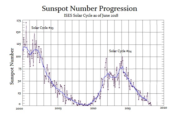
We are now in Solar Cycle 25 with peak sunspot activity expected in 2025. Solar Cycle 24 which ended in December 2019, was of average in length, at 11 years. However, it was the 4th-smallest intensity since regular record keeping began with Solar Cycle 1 in 1755. We’re now in Solar Cycle 25 and we are still in Solar Minimum conditions at this time. Solar Maximum is predicted to occur midway through this cycle which may come as soon as November 2024 but no later than March 2026, with this ideal peak reaching most likely by July 2025.
Right now, the solar wave is conforming more to our model than that of NASA. The Sun has become far more active than NASA has forecast or expected. NASA is beginning to worry that this Solar Cycle 25 could become the Strongest Cycle Since Records Began. Effectively, in terms of our model terminology, Solar Cycle 25 may be a Panic Cycle. In other words, we appear to be headed into the strongest cycle on record following the weakest cycle. That is high volatility in cycle terminology.
So what does this mean for Markets?
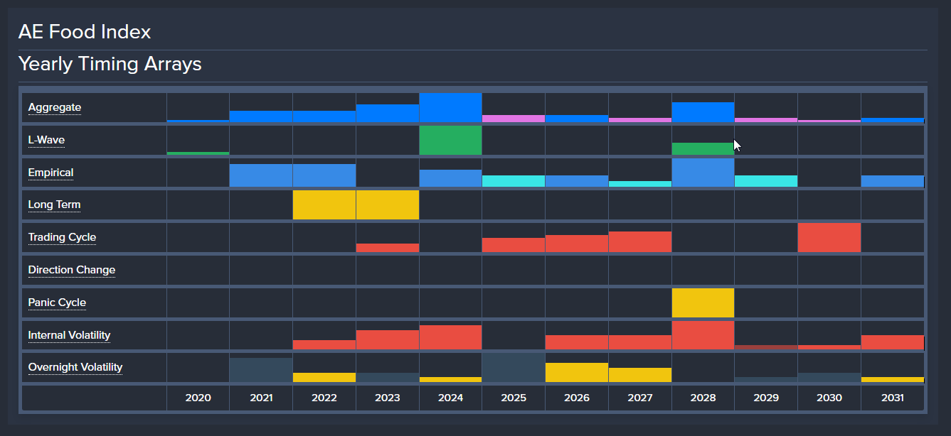
Since this Solar Minimum may continue into 2024, that appears to be a very major turning point on our global food index. Most of our models on markets are showing Panic Cycles in the 2027-2028 time period. That appears to be more war than nature.
I warned that Socrates, which monitors everything around the world, noticed a distinct correlation that more volcanos erupt during Solar Minimum. There have been many studies on the impact of UV and gamma radiation during solar changes and events. Gamma-rays are a form of electromagnetic radiation, as are radio waves, infrared radiation, ultraviolet radiation, X-rays, and microwaves. Gamma-rays can be used to treat cancer, and gamma-ray bursts are studied by astronomers.
I have also reported that our correlation models also show that solar minimums correspond to increased volcanic activity. Volcanic winters take place during solar minimums. It certainly seems that gamma-rays may be the reason volcanoes erupt more during these periods. This certainly also reduces food production and increases disease, presumably because of a rise in malnutrition. However, since gamma-rays are also used to treat cancer, there is at least a basis to warrant further investigation if the increase in gamma-rays during solar minimums impact certain susceptible people or those with particular DNA sequences.

We tend to ignore volcanos since they are not in our backyard. The deadly aspect of these volcanic eruptions is not the loudness of the boom, but how much ash it throws up into the atmosphere which then blocks the sun creating Volcanic Winter.
Go to the beach on a partly cloudy day. When a cloud blocks the sun it suddenly gets cool. This is common sense. As far as volcanoes blocking the sun, well all someone has to do is read: The Year Without Summer: 1816 and the Volcano That Darkened the World and Changed History
 Mount Tambora (VEI 7) erupted in 1816 and threw into the air so much ash that it snowed during the summer in New York City. It became known as 18-hundred-and-froze-to-death. This account from history tells the story that 1816 was a year when the sunlight could not penetrate the natural pollution from Tambora. As a result of a volcanic eruption at Mount Tambora in Indonesia, weather patterns were disrupted worldwide for months, allowing for excessive rain, frost, and snowfall through much of the Northeastern U.S. and Europe in the summer of 1816.
The global cooling altered the natural weather and it resulted in a serious food shortage that set off a mass migration from New England to the Midwest within the USA as people were trying to find the sun. Some saw this as an omen and there was also a religious revival.
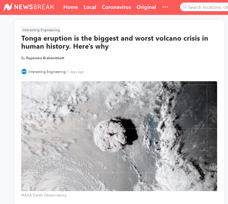
Almost one year has now passed since the Hunga-Tonga-Hunga-Ha’apai volcano erupted (VEI 5). Only now are we starting to realize that this eruption was the biggest volcanic event in human history. They have mapped the 22,000 km(2) area around the Tonga volcano. This has curiously taken place with the weakest solar minimum on record. More significantly, such a major explosion takes about one year before its true impact is understood worldwide.
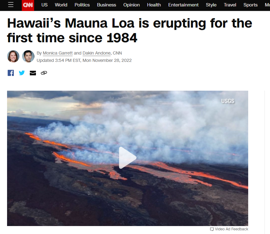
Mauna Loa, which is the largest volcano in the world covers half the island of Hawaii. It has erupted 33 times since 1843 making this an average cycle of 5.4 years. It tends not to be extremely violent as many others. Hawaii’s Mauna Loa has therefore erupted for the first time in decades but nearby, Kilauea is also erupting and both on the archipelago’s Big Island. Dual eruptions haven’t been seen since 1984.
The last eruption took place in 1984, making this prolonged quiet period the volcano’s longest in recorded history. More interesting, it is near Kilauea which erupted in 2018. The concern is not this volcano by itself. We are looking around the world at increased volcanic activity for the danger is a volcanic winter coming on top of these shortages manufactured by COVID restrictions.
There has been activity which has been detected in Alaska under what has been an 800-year dormant volcano near Sitka known as Mount Edgecumbe. This volcano was believed to have been extinct since it has not been active for at least 800 years. Earthquakes began earlier this year.
Just in August, in Indonesia, the Anak Krakatau Volcano erupted in Seven Explosions within Two Days. It unleashed 1500-Metre-High Scorching Ash.
The Ahyi Seamount is the largest submarine volcano which lies 449 feet deep in the Pacific Ocean below the Northern Mariana Islands, which are more than 3,700 miles west of Honolulu.
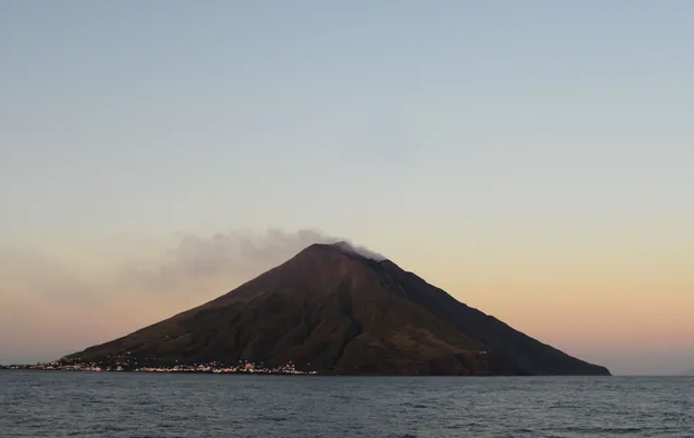
Meanwhile, over in Italy, the Stromboli volcano has also erupted also during October 2022. Several explosions inside of Italy’s Stromboli volcano sent enormous plumes of smoke into the sky and major streams of lava into the Tyrrhenian Sea over the weekend.
Over in Russia, its Shiveluch volcano has become active and now a powerful explosion is considered possible at any moment. It is one of the largest in the Russian far East volcanos recorded and it has had volcanic ash plume rising up to around 13000ft altitude.
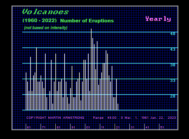
There were 5 eruptions last year around the world at 5 or higher on the Volcanic Explosivity Index (VEI). The first two eruptions here in 2022 were Bezymianny in Russia during May and Popocatépetl in Mexico during June. There was only one in 2020, but 5 during 2019. It appears we are witnessing a rise in global activity that is starting from a general major low in volcanic activity overall.
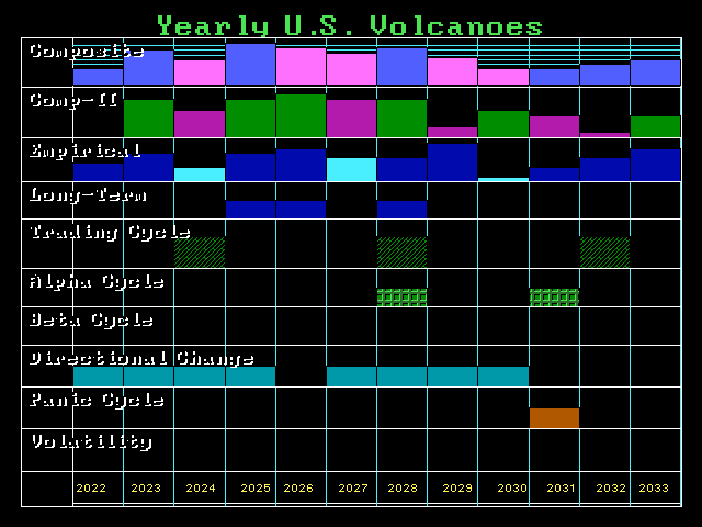
We have a string of Directional Changes between 2022 and 2025. We may be looking at rising volcanic activity into 2025. We will run our models on intensity as well. The undersea Hunga Tonga-Hunga Ha’apai eruption of December 2021 into January 14-15, 2022 was a volcanic explosivity equivalent to VEI 5. It was an eruption of a magnitude greater than the 1991 eruption of Pinatubo in The Philippines. According to a news article, the main undersea international fiber-optic communication cable that had been severed in multiple places due to the eruption had been repaired by February 21, 2022, and internet connectivity was restored the following day.
The sheer magnitudes of this eruption tends to warn that we may in fact witness a very significant rise in both the frequency of eruptions as well as the magnitude into 2025. The VEI describes the size of explosive volcanic eruptions based on magnitude and intensity. The numerical scale (from 0 to 8) is a logarithmic scale, and is therefore similar to the Richter and other magnitude scales for the size of earthquakes.
The largest eruption of magna took place at Yellowstone at Huckleberry Ridge about 2.1 million years ago. Our cycle models on Yellowstone have turned up and the “ideal” target would be in the year 2100. The difference between a VEI5 and VEI6 is a factor of 10 to 100.
alpha
Veteran Member
Electroverse
 Articles Extreme Weather
This year, Surface Mass Balance (SMB) gains –a reading to determine the ‘health’ of a glacier– are breaking records, yet this is how CNN chose to report on developments back in July:
“The amount of ice that melted in Greenland between July 15 and 17 was enough to fill 7.2 million Olympic-sized swimming pools, or cover the entire state of West Virginia with a foot of water.”
This, I’m sure, sounds rather ‘catastrophic’ to the average alarmists, but with context the obfuscation is revealed.
CNN were talking about the period of melting circled below:

Small SMB loses make international news.
This was the height of the melt season — melting is normal, hence the name.
What CNN, the BBC, and The Guardian et al. also conveniently failed to mention is that Greenland’s SMB readings (blue line) held above the 1981-2010 average for the vast majority of the season — this is the story here, MSM, not some paltry 2-day loss.
Fast-forwarding six-or-so weeks, and we note remarkable gains posted in early-August:

Large SMB gains are ignored.
Needless to say, this impressive summer spike also went unreported by the legacy media, further exposing their bias.
If these narrative-pushing puppets had even a modicum of interest in reporting the truth, they’d be all over such summer gains, asking honest questions, and perhaps even questioning their ‘global warming hypothesis’ altogether.
They’d also be covering the goings-on occurring this new season (which commenced Sept 1, 2022).
Yesterday alone (Wed, Nov 30), the Greenland ice sheet gained a whopping 8 Gigatons of mass. This is enough to bury Central Park, New York City under almost 9,000 feet ice — look CNN, I can run dumb, decontextualized headlines, too!

[DMI]
A far more worthwhile endeavor, however, would be to look at the season overall.
As shown below, 2022-2023 SMB gains have been tracking not only above the multidecadal mean but also higher than ever-before registered in DMI books which date back to 1981:

[DMI]
This is the story, MSM.
It destroys your agenda, I know, I know — truth often does.
The continent logged its coldest-ever ‘coreless winter’ (April-Sept) last year, and is continuing the cooling trend this in 2022, posting a string of colder-than-average months and, just two-weeks ago, suffering its latest -60C (76F) ever recorded.
Most recently, Antarctica has gone and posted another anomalously-cold month.
Both the South Pole Station and Vostok have registered their coldest Novembers in 35 years.
The former registered a provisional monthly average of -40.4C (-40.7F), which is a substantial -3.2C below the multidecadal average; while Vostok logged -44.3C (47.7F), which is narrowly bested by Nov 1987’s -45C (-49F).

Stefano Di Battista
@pinturicchio_60
It hadn't been this cold in November for 35 years At South Pole Station the provisional monthly average is -40.4 °C i.e. -3.2 °C baseline 1991-2020 (in 1987 was -42.1 °C) In Vostok the same data recorded -44.3 °C (in 1987 was -45.0 °C) 1/2 https://t.co/shMfLSpC1r
3:00 AM · Nov 30, 2022
For reference, the coldest-ever November average temperature at the South Pole Station remains the -43.1C (-45.6F), with Vostok’s coming in at -45.4C (-49.7F) — both set in 1983. Also for reference, the fact that Antarctica is cooling blows apart the AGW Party’s ‘Polar Amplification’ theory--as discussed in more detail below…

Summer Frosts In The Highlands Of Portugal & Spain, As Record Heat Sweeps Italy: Low Solar Activity & A ‘Meridional’ Jet Stream, Explained
The AGW hypothesis can confidently explain Central Europe’s heatwave; but it fails when it comes to Western Europe’s simultaneous summer freeze. A new theory is needed: ‘low solar activity’.
China’s Big Freeze Intensifies–Beijing’s Lowest Nov Temp Since 1970
Following yesterday’s report of record cold, frozen livestock, missing herders and killed road workers, China’s ‘big freeze’ has intensify and expanded south.
The north’s punishing cold wave, responsible for delivering record-breaking monthly lows nearing -50C to Xinjiang, is now expanding south, engulfing all of southern China as well as northern Vietnam — where it’s felling additional records.
The cold is truly brutal: Enhe AWS plunged to -42.7C (-44.9F), with Genhe hitting -37.5C (-35.5F) — both new monthly benchmarks.
The chill has also permeated metropolitan areas, too–despite the UHI effect.
In Beijing, for example, thermometers tanked to -10.8C (12.6F) on Wednesday — the capital’s lowest November reading since 1970; while in Tianjin, a city located 150km to the SE, a new all-time November low was set with its reading of -11.7C (10.9F).

Jim yang
@yangyubin1998
This morning, the core of the cold wave came to northeast China. Enhe AWS dropped to - 42.7℃, and Genhe dropped to - 37.5℃. In addition,Beijing - 10.8℃, the lowest temperature in November since 1970;Tianjin - 11.7℃, setting a new record for the lowest temperature in November! https://t.co/35vHB1R1gk

7:05 AM · Nov 30, 2022
Quiet Sun
Today, the Earth-facing solar disk is almost blank — just one small sunspot region is visible.
Despite us knocking on the door of a Solar Maximum, the Sun remains eerily quiet:

Looking to southeastern limb, however, eagle eyes should be able to see the emergence of a new sunspot cluster — and it looks noteworthy. Stay tuned for updates over the coming days.
The COLD TIMES are returning, the mid-latitudes are REFREEZING in line with historically low solar activity, cloud-nucleating Cosmic Rays, and a meridional jet stream flow (among many other forcings, including the impending release of the Beaufort Gyre).
Yesterday, Greenland Gained Enough Mass To Bury Central Park Under 9,000 Feet Of Ice; Antarctica’s Coldest Month Of November Since 1987; China’s Big Freeze Intensifies–Beijing’s Lowest Nov Temp Since 1970; + Quiet Sun
December 1, 2022 Cap AllonYesterday, Greenland Gained Enough Mass To Bury Central Park Under 9,000 Feet Of Ice
For evidence of mainstream media obfuscation and agenda-driving drivel you need look no further than their reporting of the Greenland ice sheet.This year, Surface Mass Balance (SMB) gains –a reading to determine the ‘health’ of a glacier– are breaking records, yet this is how CNN chose to report on developments back in July:
“The amount of ice that melted in Greenland between July 15 and 17 was enough to fill 7.2 million Olympic-sized swimming pools, or cover the entire state of West Virginia with a foot of water.”
This, I’m sure, sounds rather ‘catastrophic’ to the average alarmists, but with context the obfuscation is revealed.
CNN were talking about the period of melting circled below:

Small SMB loses make international news.
This was the height of the melt season — melting is normal, hence the name.
What CNN, the BBC, and The Guardian et al. also conveniently failed to mention is that Greenland’s SMB readings (blue line) held above the 1981-2010 average for the vast majority of the season — this is the story here, MSM, not some paltry 2-day loss.
Fast-forwarding six-or-so weeks, and we note remarkable gains posted in early-August:

Large SMB gains are ignored.
Needless to say, this impressive summer spike also went unreported by the legacy media, further exposing their bias.
If these narrative-pushing puppets had even a modicum of interest in reporting the truth, they’d be all over such summer gains, asking honest questions, and perhaps even questioning their ‘global warming hypothesis’ altogether.
They’d also be covering the goings-on occurring this new season (which commenced Sept 1, 2022).
Yesterday alone (Wed, Nov 30), the Greenland ice sheet gained a whopping 8 Gigatons of mass. This is enough to bury Central Park, New York City under almost 9,000 feet ice — look CNN, I can run dumb, decontextualized headlines, too!

[DMI]
A far more worthwhile endeavor, however, would be to look at the season overall.
As shown below, 2022-2023 SMB gains have been tracking not only above the multidecadal mean but also higher than ever-before registered in DMI books which date back to 1981:

[DMI]
This is the story, MSM.
It destroys your agenda, I know, I know — truth often does.
Antarctica’s Coldest Month Of November Since 1987
Antarctica appears to be cooling…The continent logged its coldest-ever ‘coreless winter’ (April-Sept) last year, and is continuing the cooling trend this in 2022, posting a string of colder-than-average months and, just two-weeks ago, suffering its latest -60C (76F) ever recorded.
Most recently, Antarctica has gone and posted another anomalously-cold month.
Both the South Pole Station and Vostok have registered their coldest Novembers in 35 years.
The former registered a provisional monthly average of -40.4C (-40.7F), which is a substantial -3.2C below the multidecadal average; while Vostok logged -44.3C (47.7F), which is narrowly bested by Nov 1987’s -45C (-49F).
Stefano Di Battista
@pinturicchio_60
It hadn't been this cold in November for 35 years At South Pole Station the provisional monthly average is -40.4 °C i.e. -3.2 °C baseline 1991-2020 (in 1987 was -42.1 °C) In Vostok the same data recorded -44.3 °C (in 1987 was -45.0 °C) 1/2 https://t.co/shMfLSpC1r
3:00 AM · Nov 30, 2022
For reference, the coldest-ever November average temperature at the South Pole Station remains the -43.1C (-45.6F), with Vostok’s coming in at -45.4C (-49.7F) — both set in 1983. Also for reference, the fact that Antarctica is cooling blows apart the AGW Party’s ‘Polar Amplification’ theory--as discussed in more detail below…
Summer Frosts In The Highlands Of Portugal & Spain, As Record Heat Sweeps Italy: Low Solar Activity & A ‘Meridional’ Jet Stream, Explained
The AGW hypothesis can confidently explain Central Europe’s heatwave; but it fails when it comes to Western Europe’s simultaneous summer freeze. A new theory is needed: ‘low solar activity’.
China’s Big Freeze Intensifies–Beijing’s Lowest Nov Temp Since 1970
Following yesterday’s report of record cold, frozen livestock, missing herders and killed road workers, China’s ‘big freeze’ has intensify and expanded south.
The north’s punishing cold wave, responsible for delivering record-breaking monthly lows nearing -50C to Xinjiang, is now expanding south, engulfing all of southern China as well as northern Vietnam — where it’s felling additional records.
The cold is truly brutal: Enhe AWS plunged to -42.7C (-44.9F), with Genhe hitting -37.5C (-35.5F) — both new monthly benchmarks.
The chill has also permeated metropolitan areas, too–despite the UHI effect.
In Beijing, for example, thermometers tanked to -10.8C (12.6F) on Wednesday — the capital’s lowest November reading since 1970; while in Tianjin, a city located 150km to the SE, a new all-time November low was set with its reading of -11.7C (10.9F).
Jim yang
@yangyubin1998
This morning, the core of the cold wave came to northeast China. Enhe AWS dropped to - 42.7℃, and Genhe dropped to - 37.5℃. In addition,Beijing - 10.8℃, the lowest temperature in November since 1970;Tianjin - 11.7℃, setting a new record for the lowest temperature in November! https://t.co/35vHB1R1gk
7:05 AM · Nov 30, 2022
Quiet Sun
Today, the Earth-facing solar disk is almost blank — just one small sunspot region is visible.
Despite us knocking on the door of a Solar Maximum, the Sun remains eerily quiet:

Looking to southeastern limb, however, eagle eyes should be able to see the emergence of a new sunspot cluster — and it looks noteworthy. Stay tuned for updates over the coming days.
The COLD TIMES are returning, the mid-latitudes are REFREEZING in line with historically low solar activity, cloud-nucleating Cosmic Rays, and a meridional jet stream flow (among many other forcings, including the impending release of the Beaufort Gyre).
northern watch
TB Fanatic
From my email inbox The Old Farmer's Almanac December 1 2022

alpha
Veteran Member
Electroverse
 Extreme Weather
Officially commencing in Dec, 2019, SC25 is progressing within the expected range; that is, the cycle is on course to be another historically weak one, markedly lower than SC21, SC22 and SC23, and although currently stronger than SC24, the ‘gap is closing’…

Solar Cycle 25 progression (green line) compared to 24, 23, 22 & 21 [updated Dec 2, 2022 — solen.info]
…thanks to a stepping down in November.
Last month saw the sunspot number –a great barometer for solar activity– turn lower, as visualized by the SILSO graphic below:

Solar Cycle 25 looks on course to rival the historically weak cycles of the early-1900s (the Centennial Minimum)–similar to SC24:

Solar Cycle 25 progression (green line) compared to 24, 16, 14, 13 & 12 [updated Dec 2, 2022 — solen.info]
Grand Solar Minimum 101: The Future Looks Cold

The Sun is at its weakest state in more than a century, and the impacts on Earth’s weather/climate are unfolding before our eyes, whether we know it or not…
Following its coldest winter on record and a colder-than-average spring, Brisbane began the new season on Thursday with more anomalously-cold conditions as temperatures plunged well-below December norms.
“It’s been a very unusual first day of summer,” said Bureau of Meteorology forecaster Pieter Claassen.
“Right across southeast Queensland, we’re seeing daytime temperatures only reaching the mid-to-high teens (C) … on track with the coldest temperatures that we ever see in south-eastern Queensland in December … across the region, we’re eight to 14 degrees below average,” added Claassen.
Meteorologists will once again be reaching for the record books, according to Claassen.
“The reason for that is we have a lot of cloud cover and we have quite a bit of rainfall … and underneath all that is cool and dry south-easterly winds,” he said.
“When that rain falls into those dry winds, we actually get what we like to think of as an air-conditioning effect, where the rain evaporates in the dry winds and takes more heat out of the environment and things get cooler and cooler.”
Claasson foresees the colder-than-average weather lingering for another week, which seems optimistic when looking at the latest GFS run, which is predicting yet another blast of Antarctic air sweeping southern and eastern parts mid-month:

GFS 2m Temperature Anomalies (C) Dec 12 – Dec 15 [tropicaltidbits.com].
November 2022 in Canada was colder-than-average, finishing with a temperature anomaly of -0.24C below the multidecadal norm, according to the official data compiled by Environment and Climate Change Canada (ECCC).
It was extremely cold across British Columbia, Alberta, Saskatchewan and Nunavut; while mild in Yukon and the Southeast.
November was colder-than-usual throughout the Thompson-Okanagan, B.C.,with snowfall hitting the region early in the month. A myriad of daily/monthly snowfall records were broken, including the two daily records felled in Penticton on Nov 6 and 8.
ECCC has said that the early injection of Arctic air could mean a long, cold winter for much of Canada.
The mean temperature in Kelowna, for example, came out at -1.8C, well-below the average of 2.6; with Cranbrook Airport holding at -6.4C — its third-coldest November in books dating back to 1901.
These aren’t cherry-picked locations, either — it was an exceptionally cold November across British Columbia, as revealed by the table below, courtesy of ECCC:

Long-standing benchmarks have been busted in Saskatchewan, and all.
Most notably the -43.9C logged at Key Lake on Nov 30, which is now the locale’s lowest November reading on record and only 1.1C off the province’s coldest temperature ever, set at Prince Albert on Nov 23, 1884.
Canada’s big freeze has extended into December, too, with additional snowfall and freeze warnings issued…
Environment Canada has issued a winter weather warnings across much of the country, including Saskatchewan; and likewise, below the border, the National Weather Service has done likewise, particularly for Sierra/Rockies snow.
Snow fell in Moose Jaw, Sask. Thursday, with a high of just -9C registered and a windchill of -22C.
Things were forecast to step up a notch overnight, with lows of -22C and a ‘frostbite danger’ predicted (windchill of -33C). An additional 10cm of snow was also on the cards, totals that would comfortably set a new benchmark for “the greatest snowfall in recent history,” reports moosejawtoday.com — besting the 6.5cm from Dec 1, 1993 and the 7.4cm from Dec 2, 1991.
Elsewhere, ECCC has issued an extreme cold warning for B.C.’s Peace River regions, as well as Chilcotin as temperatures near -40C: “Dress warmly. The outer layer should be wind resistant,” read the warning, further noting that frostbite can develop within minutes on exposed skin, especially with such a fierce wind chill.
Puntzi Mountain was the coldest spot in B.C. Thursday morning, with its low of -38.8C; while a reading of -28.9C was logged in Williams Lake, with a daytime high of just -20C; Quesnel saw a low of -27.5C, with a high around -21C; and in the Bella Coola Valley, an Arctic outflow warning remains in effect for inland sections — a deep freeze that shows no real signs of abating.
Special weather statements are also up for most of Vancouver Island and the south coast.
“It looks like things are in tune with that La Nina pattern, which usually brings us cooler winters here in B.C.,” said ECCC.
And in the United States, a windy, winter storm packed with heavy snow moved into the Sierra Thursday, where it soon closed schools at Lake Tahoe, prompted a backcountry avalanche warning and snarled traffic on Interstate 80 west of Reno.
A winter storm warning remains in effect into Friday from south of Yosemite National Park to about 200 miles north of Reno and Lake Tahoe, where more feet of snow are expected around the lake, the National Weather Service said.
“The combination of heavy snow and wind will bring periods of whiteout conditions,” warned the service.
The Sierra Avalanche Center in Truckee issued a backcountry avalanche warning through Friday for the Central Sierra Nevada, including the Tahoe area.
“Feet of new snow and strong winds will overload an already weak snowpack and result in very dangerous avalanche conditions in the mountains,” the center said Thursday.
Eastern Washington is also looking at more snow. This is after the likes of Spokane endured their snowiest Novembers in a decade+ — and there’s much more where all that came from:

GFS Total Snowfall (inches) Dec 2 – Dec 18 [tropicaltidbits.com].
The cold has also been fierce and record-breaking.
Much of Napa County is under a freeze warning into Friday, along with parts of Sonoma and Marin counties, with Santa Clara and Alameda under a freeze watch, according to the NWS.
The low temperature in Napa overnight Thursday was expected to challenge the record low of 28F set back in 1932, with the lows forecast to be similar across the majority of Napa County communities, according to AccuWeather.
The COLD TIMES are returning, the mid-latitudes are REFREEZING in line with historically low solar activity, cloud-nucleating Cosmic Rays, and a meridional jet stream flow (among many other forcings, including the impending release of the Beaufort Gyre).
Solar Output Stepped Down In November; Eastern Aussie Temps To Remain Cool During “Very Unusual” Start To Summer; Colder-Than-Average Nov For Canada; + Fresh Snow And Freeze Warnings Issued Across North America
December 2, 2022 Cap AllonSolar Output Stepped Down In November
Solar activity has been subdued of late, which has, for the most part, been the story of Solar Cycle 25 (SC25).Officially commencing in Dec, 2019, SC25 is progressing within the expected range; that is, the cycle is on course to be another historically weak one, markedly lower than SC21, SC22 and SC23, and although currently stronger than SC24, the ‘gap is closing’…
Solar Cycle 25 progression (green line) compared to 24, 23, 22 & 21 [updated Dec 2, 2022 — solen.info]
…thanks to a stepping down in November.
Last month saw the sunspot number –a great barometer for solar activity– turn lower, as visualized by the SILSO graphic below:

Solar Cycle 25 looks on course to rival the historically weak cycles of the early-1900s (the Centennial Minimum)–similar to SC24:

Solar Cycle 25 progression (green line) compared to 24, 16, 14, 13 & 12 [updated Dec 2, 2022 — solen.info]
Grand Solar Minimum 101: The Future Looks Cold
The Sun is at its weakest state in more than a century, and the impacts on Earth’s weather/climate are unfolding before our eyes, whether we know it or not…
Eastern Aussie Temps To Remain Cool During “Very Unusual” Start To Summer
Following its coldest winter on record and a colder-than-average spring, Brisbane began the new season on Thursday with more anomalously-cold conditions as temperatures plunged well-below December norms.“It’s been a very unusual first day of summer,” said Bureau of Meteorology forecaster Pieter Claassen.
“Right across southeast Queensland, we’re seeing daytime temperatures only reaching the mid-to-high teens (C) … on track with the coldest temperatures that we ever see in south-eastern Queensland in December … across the region, we’re eight to 14 degrees below average,” added Claassen.
Meteorologists will once again be reaching for the record books, according to Claassen.
“The reason for that is we have a lot of cloud cover and we have quite a bit of rainfall … and underneath all that is cool and dry south-easterly winds,” he said.
“When that rain falls into those dry winds, we actually get what we like to think of as an air-conditioning effect, where the rain evaporates in the dry winds and takes more heat out of the environment and things get cooler and cooler.”
Claasson foresees the colder-than-average weather lingering for another week, which seems optimistic when looking at the latest GFS run, which is predicting yet another blast of Antarctic air sweeping southern and eastern parts mid-month:

GFS 2m Temperature Anomalies (C) Dec 12 – Dec 15 [tropicaltidbits.com].
Colder-Than-Average Nov For Canada
November 2022 in Canada was colder-than-average, finishing with a temperature anomaly of -0.24C below the multidecadal norm, according to the official data compiled by Environment and Climate Change Canada (ECCC).It was extremely cold across British Columbia, Alberta, Saskatchewan and Nunavut; while mild in Yukon and the Southeast.
November was colder-than-usual throughout the Thompson-Okanagan, B.C.,with snowfall hitting the region early in the month. A myriad of daily/monthly snowfall records were broken, including the two daily records felled in Penticton on Nov 6 and 8.
ECCC has said that the early injection of Arctic air could mean a long, cold winter for much of Canada.
The mean temperature in Kelowna, for example, came out at -1.8C, well-below the average of 2.6; with Cranbrook Airport holding at -6.4C — its third-coldest November in books dating back to 1901.
These aren’t cherry-picked locations, either — it was an exceptionally cold November across British Columbia, as revealed by the table below, courtesy of ECCC:

Long-standing benchmarks have been busted in Saskatchewan, and all.
Most notably the -43.9C logged at Key Lake on Nov 30, which is now the locale’s lowest November reading on record and only 1.1C off the province’s coldest temperature ever, set at Prince Albert on Nov 23, 1884.
Canada’s big freeze has extended into December, too, with additional snowfall and freeze warnings issued…
Fresh Snow And Freeze Warnings Issued Across North America
Environment Canada has issued a winter weather warnings across much of the country, including Saskatchewan; and likewise, below the border, the National Weather Service has done likewise, particularly for Sierra/Rockies snow.Snow fell in Moose Jaw, Sask. Thursday, with a high of just -9C registered and a windchill of -22C.
Things were forecast to step up a notch overnight, with lows of -22C and a ‘frostbite danger’ predicted (windchill of -33C). An additional 10cm of snow was also on the cards, totals that would comfortably set a new benchmark for “the greatest snowfall in recent history,” reports moosejawtoday.com — besting the 6.5cm from Dec 1, 1993 and the 7.4cm from Dec 2, 1991.
Elsewhere, ECCC has issued an extreme cold warning for B.C.’s Peace River regions, as well as Chilcotin as temperatures near -40C: “Dress warmly. The outer layer should be wind resistant,” read the warning, further noting that frostbite can develop within minutes on exposed skin, especially with such a fierce wind chill.
Puntzi Mountain was the coldest spot in B.C. Thursday morning, with its low of -38.8C; while a reading of -28.9C was logged in Williams Lake, with a daytime high of just -20C; Quesnel saw a low of -27.5C, with a high around -21C; and in the Bella Coola Valley, an Arctic outflow warning remains in effect for inland sections — a deep freeze that shows no real signs of abating.
Special weather statements are also up for most of Vancouver Island and the south coast.
“It looks like things are in tune with that La Nina pattern, which usually brings us cooler winters here in B.C.,” said ECCC.
And in the United States, a windy, winter storm packed with heavy snow moved into the Sierra Thursday, where it soon closed schools at Lake Tahoe, prompted a backcountry avalanche warning and snarled traffic on Interstate 80 west of Reno.
A winter storm warning remains in effect into Friday from south of Yosemite National Park to about 200 miles north of Reno and Lake Tahoe, where more feet of snow are expected around the lake, the National Weather Service said.
“The combination of heavy snow and wind will bring periods of whiteout conditions,” warned the service.
The Sierra Avalanche Center in Truckee issued a backcountry avalanche warning through Friday for the Central Sierra Nevada, including the Tahoe area.
“Feet of new snow and strong winds will overload an already weak snowpack and result in very dangerous avalanche conditions in the mountains,” the center said Thursday.
Eastern Washington is also looking at more snow. This is after the likes of Spokane endured their snowiest Novembers in a decade+ — and there’s much more where all that came from:

GFS Total Snowfall (inches) Dec 2 – Dec 18 [tropicaltidbits.com].
The cold has also been fierce and record-breaking.
Much of Napa County is under a freeze warning into Friday, along with parts of Sonoma and Marin counties, with Santa Clara and Alameda under a freeze watch, according to the NWS.
The low temperature in Napa overnight Thursday was expected to challenge the record low of 28F set back in 1932, with the lows forecast to be similar across the majority of Napa County communities, according to AccuWeather.
The COLD TIMES are returning, the mid-latitudes are REFREEZING in line with historically low solar activity, cloud-nucleating Cosmic Rays, and a meridional jet stream flow (among many other forcings, including the impending release of the Beaufort Gyre).
northern watch
TB Fanatic
From my email inbox The Old Farmer's Almanac December 2 2022

alpha
Veteran Member
Global Warming? Northern Hemisphere Snow Cover At 56-Year High
by Tyler DurdenSaturday, Dec 03, 2022 - 03:00 PM
The COP27 climate change conference wrapped up last month. World leaders flew in private jets to Egypt to discuss how fossil fuels were quickly heating the planet to the point of no return, as humanity was doomed if crucial climate change policies weren't implemented. But while the climate alarmist leaders met in the desert, November's snowfall across the Northern Hemisphere was running at rates exceeding a half-a-century average.
NOAA and Rutgers University released new data that showed snow cover across the Northern Hemisphere reached the highest level since measurements began in 1967 and are currently above the 56-year mean.
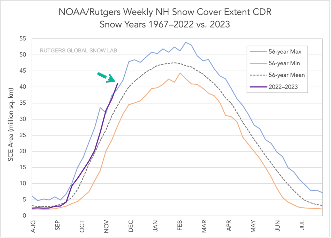
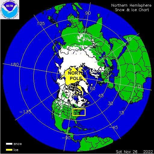
Here's the Rutgers Global Snow Lab snow coverage map across the Northern Hemisphere.

And another from NOAA with more resolution.
"Extensive snow extent early in the season is an indicator of persistent cold as we head into winter proper," weather blog Severe Weather Europe said.
Most mainstream media outlets overlooked this data because it is an inconvenient truth for the climate change narrative they're pushing.
A severe winter for the Northern Hemisphere might complicate power grids for western countries that are hellbent on disrupting energy flows by sanctioning Russia, forcing the world into the worst energy crisis in a generation. Since the US and Europe's natural gas storage facilities have flipped into withdrawal season, the clock starts as storage levels could quickly wind down if temperatures stay below average, which would continue to boost energy prices.
ChicagoMan74
ULTRA MAGA
Thought I would add this here as it seems appropriate:
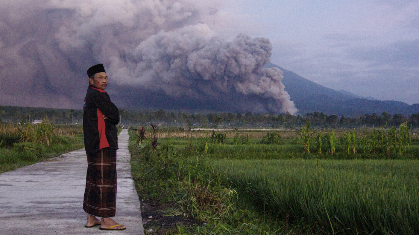
Residents are evacuating as Mount Semeru, Indonesia's highest volcano, has erupted
 www.npr.org
Residents are evacuating as Mount Semeru, Indonesia's highest volcano, has erupted
Residents are evacuating as Mount Semeru, Indonesia's highest volcano, has erupted
Monsoon rains eroded and finally collapsed the lava dome atop 3,676-meter (12,060-foot) Mount Semeru, causing the eruption, according to National Disaster Management Agency spokesperson Abdul Muhari.
www.npr.org
alpha
Veteran Member
Electroverse

Extreme Weather
The location was Oymyakon, Russia with the low being the finger-snapping -55.1C (-67.2F) logged Sunday, Dec 4:

Courtesy of @ThierryGooseBC on Twitter.
Asia’s cold has been widespread and fierce of late.
Serving as just a handful of examples, a low of -54.6C (-66.3F) was registered in Delyankir; -51.8C (-61.2F) in Agayakan; -50.5C (-58.9F) in Nera and -50C (-58F) in Yurty; while a record-challenging -41.9C (-43.4F) was logged in Tulihe, adding to the weather-related death and disruption sweeping Northern China:
Meteorological summer has commended with freezing lows (C) in New Zealand.
Overnight lows have touched 0C (32F) in some spots, such as Manapouri, Fiordland, located on the South Island.

MetService
@MetService
A chilly start to the day Many places woke up to single digit temperatures this morning with some almost reaching 0°C! Alexandra 2.7°C Waiouru 1.0°C National Park 0.7°C Manapouri 0°C MetService - Te Ratonga Tirorangi https://t.co/8bTJd5L8Hq

2:16 PM · Dec 2, 2022
While in Australia, winter-like lows are persisting for many, with snow clipping the SE mountains.
And looking ahead, further anomalous chills are forecast for later in December, expected to hit the South and East hardest:

GFS 2m Temperature Anomalies (C) Dec 17 [tropicaltidbits.com].
Record lows and historic snows are potentially on the cards as a ‘blocking high’ above Greenland threatens to set up a truly baltic-looking festive season, particularly for Northern, Western and Central nations — starting this week:

GFS 2m Temp Anomalies for early/mid-Dec (purples indicate 12C below average) for mid-Dec.

GFS Total Snowfall (inches) Dec 5 – Dec 21 [tropicaltidbits.com].
It’s a similar story across the pond, too, in North America.
Canada, in particular, is forecast record-breaking and deadly low temperatures (namely across Alberta and Sask.); while snow is on course to clip the majority of the continent, including deep into states such as Arizona and New Mexico:

GFS Total Snowfall (inches) Dec 5 – Dec 21 [tropicaltidbits.com].
This NH winter is setting up to be a doozy.
Total snowfall continues to march above the 1982-2012 average (see FMI chart in Electroverse sidebar).
While Greenland’s SMB growth continues its advance into uncharted territory:

[DMI]
The AGW Party has a lot of explaining to do…
Also, for more on the record-strong ‘blocking high’ building above Greenland, click below:
This picture below was taken by Eduardo Schaberger Poupeau of Rafaela, Argentina:

“The full disk of our star is suddenly showing a lot of activity,” said Poupeau.
There are five big sunspots and two long filaments of magnetism–all facing Earth and poised to erupt. Of special interest is sunspot AR3157, which underwent a period of hyperactivity over the weekend before it turned toward Earth:

Odds favor a geoeffective eruption –that’s one capable of causing a geomagnetic disturbance (on Earth)– this week.
The question: Is this just a temporary shift in gears, or an indication that something bigger is brewing?
Stay tuned for updates.

Sunspots AR3153 and AR3157 pose a threat for solar flares [SDO/HMI].
Extreme Weather
Siberian Freeze Strengthens (-55.1C/-67.2F); New Zealand’s Frosty Start To Summer; Arctic Air To Hit Europe This Week, Bringing Heavy Snow; + Is Solar Cycle 25 About To Awaken?
December 5, 2022 Cap AllonSiberian Freeze Strengthens (-55.1C/-67.2F)
The Northern Hemisphere has just posted its coldest temperature of the season so far.The location was Oymyakon, Russia with the low being the finger-snapping -55.1C (-67.2F) logged Sunday, Dec 4:

Courtesy of @ThierryGooseBC on Twitter.
Asia’s cold has been widespread and fierce of late.
Serving as just a handful of examples, a low of -54.6C (-66.3F) was registered in Delyankir; -51.8C (-61.2F) in Agayakan; -50.5C (-58.9F) in Nera and -50C (-58F) in Yurty; while a record-challenging -41.9C (-43.4F) was logged in Tulihe, adding to the weather-related death and disruption sweeping Northern China:
New Zealand’s Frosty Start To Summer
Meteorological summer has commended with freezing lows (C) in New Zealand.Overnight lows have touched 0C (32F) in some spots, such as Manapouri, Fiordland, located on the South Island.
MetService
@MetService
A chilly start to the day Many places woke up to single digit temperatures this morning with some almost reaching 0°C! Alexandra 2.7°C Waiouru 1.0°C National Park 0.7°C Manapouri 0°C MetService - Te Ratonga Tirorangi https://t.co/8bTJd5L8Hq
2:16 PM · Dec 2, 2022
While in Australia, winter-like lows are persisting for many, with snow clipping the SE mountains.
And looking ahead, further anomalous chills are forecast for later in December, expected to hit the South and East hardest:

GFS 2m Temperature Anomalies (C) Dec 17 [tropicaltidbits.com].
Arctic Air To Hit Europe This Week, Bringing Heavy Snow
Brutal Arctic air is readying to invade much of the European continent.Record lows and historic snows are potentially on the cards as a ‘blocking high’ above Greenland threatens to set up a truly baltic-looking festive season, particularly for Northern, Western and Central nations — starting this week:

GFS 2m Temp Anomalies for early/mid-Dec (purples indicate 12C below average) for mid-Dec.

GFS Total Snowfall (inches) Dec 5 – Dec 21 [tropicaltidbits.com].
It’s a similar story across the pond, too, in North America.
Canada, in particular, is forecast record-breaking and deadly low temperatures (namely across Alberta and Sask.); while snow is on course to clip the majority of the continent, including deep into states such as Arizona and New Mexico:

GFS Total Snowfall (inches) Dec 5 – Dec 21 [tropicaltidbits.com].
This NH winter is setting up to be a doozy.
Total snowfall continues to march above the 1982-2012 average (see FMI chart in Electroverse sidebar).
While Greenland’s SMB growth continues its advance into uncharted territory:

[DMI]
The AGW Party has a lot of explaining to do…
Also, for more on the record-strong ‘blocking high’ building above Greenland, click below:
Is Solar Cycle 25 About To Awaken?
As we discussed on Friday, solar activity has –so far– been historically low during SC25 with only a handful of strong flares and no CMEs landing a direct hit on Earth. Over the past few days, however, the Sun has shown signs of stirring…This picture below was taken by Eduardo Schaberger Poupeau of Rafaela, Argentina:

“The full disk of our star is suddenly showing a lot of activity,” said Poupeau.
There are five big sunspots and two long filaments of magnetism–all facing Earth and poised to erupt. Of special interest is sunspot AR3157, which underwent a period of hyperactivity over the weekend before it turned toward Earth:

Odds favor a geoeffective eruption –that’s one capable of causing a geomagnetic disturbance (on Earth)– this week.
The question: Is this just a temporary shift in gears, or an indication that something bigger is brewing?
Stay tuned for updates.

Sunspots AR3153 and AR3157 pose a threat for solar flares [SDO/HMI].
alpha
Veteran Member
Electroverse
 Articles Extreme Weather
Météo-France placed 24 departments under weather warnings, with the weather agency foreseeing intensifying wintry conditions as the week progresses, with temps holding 5C below the norm — a first resilience test of the French power grid.
In Lozere, significant snowfall on Monday left motorists stranded on the A75:
link
While at higher elevations, ski season has commenced at many resorts, such as Val Thorens, in the French Alps this weekend. However, six mountainous resorts, from Haute-Savoie to Alpes-Maritimes, have had their fun tempered by the issuance of ‘avalanche watches’.
The below tweet reads, “[snow fell at] Gap, the capital of the Hautes Alpes … 300m (985ft) lower than expected.”
link
Plunging temperatures, in particular, will test the resilience of France’s power network, with even President Emmanuel Macron urging the French, in a public address, not to panic amid warnings of possible blackouts.
French utility EDF saw its electricity output drop to a 3-decade low in 2022 due to a record number of nuclear reactor outages arising from “corrosion problems”. And on Monday, arriving in line with the cold, came the news that at least two of the country’s offline reactors will experience further delays.
A mild November helped ease demand, but as the mercury fell on Monday, concerns rose, with people again prompted to download the government’s ‘alert app’ which is designed to warn of high demand and potential power cuts.
Currently, France’s low nuclear availability is being offset by higher imports from its neighbors. However, with this week’s Arctic outbreak not limited to France, the fear is that help won’t be on offer for much longer as nation’s prioritize domestic security.
“We do see France hitting its import limitations,” said Jean-Paul Harreman, director of EnAppSys energy consultancy. And with even colder weather forecast next week (Dec 12), supplies “will be even tighter,” so says Refinitiv analyst Nathalie Gerl.
“Consumption is set to peak at 80 GW (versus 73 GW on Dec 5), while wind power is expected to be below normal. Should the nuclear availability remain at 37-38 GW the supply gap risk will be much more acute than today,” explained Gerl.
As hinted at above, this influx of polar cold has been widespread, infecting much of the European continent.
The UK, for example, has suffered its first real taste of winter, with snow and ice the common theme.
Below is the current scene in Wales where a feels-like of -10C (14F) and snow clipped the higher elevations:

A frozen mini digger on the Snowdon Mountain Railway.
While in Norway, an energy rich nation that often offers its spare capacity to its European neighbors, a bout of record-breaking, power-sucking cold is also being endured, which has fired the nation’s energy prices to unprecedented levels.
The price record for central Norway was shattered on Sunday after an average price of 2.71 kroner per kilowatt hour was logged.
A fierce, below-average freeze has settled in across the Nordics, resulting in residents cranking-up their heating.
And there’s much more where that came from as December rolls on — and for the majority of Europe, too:

GFS 2m Temp Anomalies for Dec 12 (purples indicate 12C below norm).

GFS 2m Temp Anomalies for Dec 14.

GFS Total Snowfall (cm) Dec 6 – Dec 22 [tropicaltidbits.com].
“First of all, let us be clear: no panic!” Macron told TF1 television over the weekend.
“It is legitimate for the government to prepare for the extreme cases which would mean cutting off electricity for a few hours per day if we did not have enough power,” he added, with a smarmy grin — after he himself continues to be knowingly complicit in the ‘controlled demolition’ of the global energy supply under the thinly veiled guise of ‘saving the planet’.
But as has been exposed now, these destructors aren’t ‘pro-planet’, rather they are mercilessly ‘anti-human’.
Reject their treacherous rhetoric.
Going by the snow totals, you’d guess it was mid-winter in the U.S. — ski areas are seeing their snowiest starts to winter in decades with the West’s snowpack, in particular, averaging twice-as-much as the seasonal norm.
With back-to-back-to-back-to-back winter storms across the West –beginning in early-November– the snowpack is thriving. Parts of the Sierra and the Pacific Northwest are seeing record-challenging depths for the time of year.
In Central California, Sierra snowpack stands at 200+% of normal, with far higher percentages logged at other basins.
“We’re looking fairly good up here at this point,” Andre Schwartz, research scientist at the University of California-Berkeley’s Central Sierra Snow Laboratory said. “We’re definitely above average, as far as how much snow we have on the ground.”
This year, frequent storms, in combination with exceptionally cold temperatures, have helped the snow to stick around.
Eyeing the forecast, the Sierra and the Rockies will be hit with again this week as multiple storm systems traverse the West.
Snowfall totals here could easily end up at 4 foot, with more widespread totals coming in at a foot or less. While across Central and Eastern states, record-challenging totals are also on the cards — for the likes of Minnesota, Nebraska, Kansas and Oklahoma:

GFS Total Snowfall (inches) Dec 6 – Dec 22 [tropicaltidbits.com].
Parts of Canada, namely Alberta and Saskatchewan, are forecast “dangerously cold” temperatures this week as “the polar vortex” drives polar air southwards, plunging the mercury to “Antarctic levels”, according to The Weather Network.
For Alberta, a dangerous freeze will enter Tuesday morning where temperatures for the northern half of the province will sink below -30C (-22F), with communities such as Edmonton bracing for -35C (-31F), with a wind chill driving temps into the -40s.
In fact, Edmonton airport has a chance of seeing actual temperatures drop to -40C Tuesday morning, which would be one of its earliest -40Cs in recorded history.
Frost bite can occur within minutes under these conditions, warns Environment ‘and Climate Cooling’ Canada (ECCC). As a result, Canadian’s are being urged to take the necessary precautions to limit exposure to the extreme cold.
Antarctica itself has been holding exceptionally cold of late, recently posting its coldest month of November since 1987.
The unseasonable cold brought with it unseasonable snow — so much snow, in fact, that the Royal Navy had to come to the aid of four UK women working at an isolated Antarctic base after its buildings were buried.
Sailors and Royal Marines from HMS Protector spent two days digging out the Port Lockroy site, and managed to fix the roof of Bransfield Hut which is home to a museum, a gift shop and the world’s most remote post office.
The four women beat 6,000 applicants to manage the base.
Clare Ballantyne, Mairi Hilton, Natalie Corbett and Lucy Bruzzone accepted the task of reopening the site in October.
They were busy setting up, assisted by three other staff who are leaving shortly, ahead of the austral summer –which falls between Nov to Feb– when an unexpected 4 meters (13+ feet) of snow put a stop to their efforts.
The sailors and Marines shifted several tonnes of snow for the women, and successfully carried out repairs.
Warrant Officer First Class Lee “Rattler” Morgan, who was part of the rescue team, said he was “taken aback” by “the sheer amount of snow,” adding that the buildings “had all but disappeared”.

As predicted, and feared, COVID Lockdowns are evolving into Climate Lockdowns, with a trial to be launched in Britain.
Oxfordshire County Council has approved plans to effectively lock residents into one of six zones due to ‘global warming’.
Under the new scheme, electronic gates will be placed on key roads in and out of the city, confining residents to their own neighborhoods. If a resident sought to leave their zone they would first need permission from the Council who gets to decide who is worthy of freedom and who isn’t.
For those seeking freedom, they will first have to register their vehicle details with the council who will then track their movements via smart cameras round the city. If you qualify, you may leave your zone for a maximum of 100 days per year. Oh, and for two-car households, both vehicles will be counted as one, meaning you’ll have to divide up the journeys.
A county council travel chief has insisted the controversial plan would go ahead whether people liked it or not.
People can drive freely around their own neighborhood and can apply for a permit to drive through the filters and into other neighbors, said the chief, but reiterated that this was only possible for up to 100 days per year.
Oxfordshire is a higher learning hub, home to the University of Oxford, and is also, in part, run by the Green Party. It follows that opposition to these Chinese-style movement restrictions will be tempered. After all, government-funded studies say the climate is heating–or something… so authoritarianism is the clear and obvious fix–or something…
As Eric Worrall writes, “Almost a thousand years the University of Oxford stood as a beacon of intellectual freedom. A number of leading Oxford intellectuals were hanged or otherwise persecuted over the centuries, because of their resistance to authoritarianism. So it seems incredibly sad that the inheritors of that proud tradition seem so willing to turn their backs on those freedoms their predecessors sometimes laid down their lives to defend.”
And as British commentator Neil Oliver says, “Anyone who puts up with this deserves whatever the overlords plan next.”
These Oxford ‘Climate Lockdowns’ are about control. For those who don’t see that by now, brace for the shackles and the tightening noose around your necks; likewise, for those not working to obtain freedom now, mentally prepare yourselves for slavery — because if you stay within their system, this future –unlike that of ‘global warming’– is baked in, inevitable.
You will obey — for a meal, for warmth, for a roof over your head — you will obey.
Snow In Three Aussie States Just Days Out From Summer (A Foot In The Mountains); Nunavut Breaks November Cold Record; Scandinavia Snow Causes “Havoc”; + India ShiversNovember 23, 2022In "Extreme Weather"
Florida Drops Below Freezing–Tallahassee, And Others, Log Earliest Freezes On Record; -31.5C (-24.7F) In Canada; Feet Of Early-Season Snow Hit Northern India; + Climate FlimflamOctober 21, 2022In "Extreme Weather"
Plunging Temperatures Tests French Power Grid: Macron, “Don’t Panic”; U.S. Snowpack At Historically High Levels; “Feels Like Antarctica” In Alberta; + Climate Lockdowns Are Here
December 6, 2022 Cap AllonPlunging Temperatures Tests French Power Grid: Macron, “Don’t Panic”
Snow and plunging temperatures swept much of France on Monday.Météo-France placed 24 departments under weather warnings, with the weather agency foreseeing intensifying wintry conditions as the week progresses, with temps holding 5C below the norm — a first resilience test of the French power grid.
In Lozere, significant snowfall on Monday left motorists stranded on the A75:
link
While at higher elevations, ski season has commenced at many resorts, such as Val Thorens, in the French Alps this weekend. However, six mountainous resorts, from Haute-Savoie to Alpes-Maritimes, have had their fun tempered by the issuance of ‘avalanche watches’.
The below tweet reads, “[snow fell at] Gap, the capital of the Hautes Alpes … 300m (985ft) lower than expected.”
link
Plunging temperatures, in particular, will test the resilience of France’s power network, with even President Emmanuel Macron urging the French, in a public address, not to panic amid warnings of possible blackouts.
French utility EDF saw its electricity output drop to a 3-decade low in 2022 due to a record number of nuclear reactor outages arising from “corrosion problems”. And on Monday, arriving in line with the cold, came the news that at least two of the country’s offline reactors will experience further delays.
A mild November helped ease demand, but as the mercury fell on Monday, concerns rose, with people again prompted to download the government’s ‘alert app’ which is designed to warn of high demand and potential power cuts.
Currently, France’s low nuclear availability is being offset by higher imports from its neighbors. However, with this week’s Arctic outbreak not limited to France, the fear is that help won’t be on offer for much longer as nation’s prioritize domestic security.
“We do see France hitting its import limitations,” said Jean-Paul Harreman, director of EnAppSys energy consultancy. And with even colder weather forecast next week (Dec 12), supplies “will be even tighter,” so says Refinitiv analyst Nathalie Gerl.
“Consumption is set to peak at 80 GW (versus 73 GW on Dec 5), while wind power is expected to be below normal. Should the nuclear availability remain at 37-38 GW the supply gap risk will be much more acute than today,” explained Gerl.
As hinted at above, this influx of polar cold has been widespread, infecting much of the European continent.
The UK, for example, has suffered its first real taste of winter, with snow and ice the common theme.
Below is the current scene in Wales where a feels-like of -10C (14F) and snow clipped the higher elevations:

A frozen mini digger on the Snowdon Mountain Railway.
While in Norway, an energy rich nation that often offers its spare capacity to its European neighbors, a bout of record-breaking, power-sucking cold is also being endured, which has fired the nation’s energy prices to unprecedented levels.
The price record for central Norway was shattered on Sunday after an average price of 2.71 kroner per kilowatt hour was logged.
A fierce, below-average freeze has settled in across the Nordics, resulting in residents cranking-up their heating.
And there’s much more where that came from as December rolls on — and for the majority of Europe, too:

GFS 2m Temp Anomalies for Dec 12 (purples indicate 12C below norm).

GFS 2m Temp Anomalies for Dec 14.

GFS Total Snowfall (cm) Dec 6 – Dec 22 [tropicaltidbits.com].
“First of all, let us be clear: no panic!” Macron told TF1 television over the weekend.
“It is legitimate for the government to prepare for the extreme cases which would mean cutting off electricity for a few hours per day if we did not have enough power,” he added, with a smarmy grin — after he himself continues to be knowingly complicit in the ‘controlled demolition’ of the global energy supply under the thinly veiled guise of ‘saving the planet’.
But as has been exposed now, these destructors aren’t ‘pro-planet’, rather they are mercilessly ‘anti-human’.
Reject their treacherous rhetoric.
U.S. Snowpack At Historically High Levels
Going by the snow totals, you’d guess it was mid-winter in the U.S. — ski areas are seeing their snowiest starts to winter in decades with the West’s snowpack, in particular, averaging twice-as-much as the seasonal norm.With back-to-back-to-back-to-back winter storms across the West –beginning in early-November– the snowpack is thriving. Parts of the Sierra and the Pacific Northwest are seeing record-challenging depths for the time of year.
In Central California, Sierra snowpack stands at 200+% of normal, with far higher percentages logged at other basins.
“We’re looking fairly good up here at this point,” Andre Schwartz, research scientist at the University of California-Berkeley’s Central Sierra Snow Laboratory said. “We’re definitely above average, as far as how much snow we have on the ground.”
This year, frequent storms, in combination with exceptionally cold temperatures, have helped the snow to stick around.
Eyeing the forecast, the Sierra and the Rockies will be hit with again this week as multiple storm systems traverse the West.
Snowfall totals here could easily end up at 4 foot, with more widespread totals coming in at a foot or less. While across Central and Eastern states, record-challenging totals are also on the cards — for the likes of Minnesota, Nebraska, Kansas and Oklahoma:

GFS Total Snowfall (inches) Dec 6 – Dec 22 [tropicaltidbits.com].
“Feels Like Antarctica” In Alberta
Parts of Canada, namely Alberta and Saskatchewan, are forecast “dangerously cold” temperatures this week as “the polar vortex” drives polar air southwards, plunging the mercury to “Antarctic levels”, according to The Weather Network.For Alberta, a dangerous freeze will enter Tuesday morning where temperatures for the northern half of the province will sink below -30C (-22F), with communities such as Edmonton bracing for -35C (-31F), with a wind chill driving temps into the -40s.
In fact, Edmonton airport has a chance of seeing actual temperatures drop to -40C Tuesday morning, which would be one of its earliest -40Cs in recorded history.
Frost bite can occur within minutes under these conditions, warns Environment ‘and Climate Cooling’ Canada (ECCC). As a result, Canadian’s are being urged to take the necessary precautions to limit exposure to the extreme cold.
A Word on Antarctica
Antarctica itself has been holding exceptionally cold of late, recently posting its coldest month of November since 1987.The unseasonable cold brought with it unseasonable snow — so much snow, in fact, that the Royal Navy had to come to the aid of four UK women working at an isolated Antarctic base after its buildings were buried.
Sailors and Royal Marines from HMS Protector spent two days digging out the Port Lockroy site, and managed to fix the roof of Bransfield Hut which is home to a museum, a gift shop and the world’s most remote post office.
The four women beat 6,000 applicants to manage the base.
Clare Ballantyne, Mairi Hilton, Natalie Corbett and Lucy Bruzzone accepted the task of reopening the site in October.
They were busy setting up, assisted by three other staff who are leaving shortly, ahead of the austral summer –which falls between Nov to Feb– when an unexpected 4 meters (13+ feet) of snow put a stop to their efforts.
The sailors and Marines shifted several tonnes of snow for the women, and successfully carried out repairs.
Warrant Officer First Class Lee “Rattler” Morgan, who was part of the rescue team, said he was “taken aback” by “the sheer amount of snow,” adding that the buildings “had all but disappeared”.

Climate Lockdowns Are Here
As predicted, and feared, COVID Lockdowns are evolving into Climate Lockdowns, with a trial to be launched in Britain.Oxfordshire County Council has approved plans to effectively lock residents into one of six zones due to ‘global warming’.
Under the new scheme, electronic gates will be placed on key roads in and out of the city, confining residents to their own neighborhoods. If a resident sought to leave their zone they would first need permission from the Council who gets to decide who is worthy of freedom and who isn’t.
For those seeking freedom, they will first have to register their vehicle details with the council who will then track their movements via smart cameras round the city. If you qualify, you may leave your zone for a maximum of 100 days per year. Oh, and for two-car households, both vehicles will be counted as one, meaning you’ll have to divide up the journeys.
A county council travel chief has insisted the controversial plan would go ahead whether people liked it or not.
People can drive freely around their own neighborhood and can apply for a permit to drive through the filters and into other neighbors, said the chief, but reiterated that this was only possible for up to 100 days per year.
Oxfordshire is a higher learning hub, home to the University of Oxford, and is also, in part, run by the Green Party. It follows that opposition to these Chinese-style movement restrictions will be tempered. After all, government-funded studies say the climate is heating–or something… so authoritarianism is the clear and obvious fix–or something…
As Eric Worrall writes, “Almost a thousand years the University of Oxford stood as a beacon of intellectual freedom. A number of leading Oxford intellectuals were hanged or otherwise persecuted over the centuries, because of their resistance to authoritarianism. So it seems incredibly sad that the inheritors of that proud tradition seem so willing to turn their backs on those freedoms their predecessors sometimes laid down their lives to defend.”
And as British commentator Neil Oliver says, “Anyone who puts up with this deserves whatever the overlords plan next.”
These Oxford ‘Climate Lockdowns’ are about control. For those who don’t see that by now, brace for the shackles and the tightening noose around your necks; likewise, for those not working to obtain freedom now, mentally prepare yourselves for slavery — because if you stay within their system, this future –unlike that of ‘global warming’– is baked in, inevitable.
You will obey — for a meal, for warmth, for a roof over your head — you will obey.
Related
Low Temp Record Set In Half Moon Bay, CA; Triple-Dip La Niña Winter Inbound (Like 1976?); + Texas Grid Found “Not Ready” For Winter, Doomed To Repeat Deadly 2021 Blackouts…October 28, 2022In "Extreme Weather"Snow In Three Aussie States Just Days Out From Summer (A Foot In The Mountains); Nunavut Breaks November Cold Record; Scandinavia Snow Causes “Havoc”; + India ShiversNovember 23, 2022In "Extreme Weather"
Florida Drops Below Freezing–Tallahassee, And Others, Log Earliest Freezes On Record; -31.5C (-24.7F) In Canada; Feet Of Early-Season Snow Hit Northern India; + Climate FlimflamOctober 21, 2022In "Extreme Weather"
Post navigation
Siberian Freeze Strengthens (-55.1C/-67.2F); New Zealand’s Frosty Start To Summer; Arctic Air To Hit Europe This Week, Bringing Heavy Snow; + Is Solar Cycle 25 About To Awaken?
alpha
Veteran Member
Electroverse

Extreme Weather
The Met Office has issued weather warnings for Wednesday and Thursday, with bone-chilling lows, blizzard conditions and snow drifts likely thanks to strong, descending Arctic winds.
Daytime highs will struggle to rise above 0C (32F) across large parts of Britain, even in southern areas.
Forecasters have warned that the low temperatures will persist into next week, too, as a record-strong blocking high over Greenland threatens to consistently funnel polar cold over Europe , which will strain the continent’s already creaking energy infrastructure.

Electroverse
@Electroversenet
Warnings issued across the UK for "severe cold". Brits are being urged to use their heating, despite high energy prices and the threat of looming blackouts. The BBC is also conditioning people to expect excess heart-attacks as a result of plunging temps... UK weather: Met Office warns of below freezing temperatures
8:38 AM · Dec 5, 2022
And while the UK shivers, some truly Baltic conditions will invade more central European nations.
As visualized by the latest GFS run below, nations such as Poland and Denmark, as well as the embattled –soon to be former– powerhouse Germany, which is on the brink of successfully committing energy suicide which will involve the murder of millions of its own citizens in the name of ‘saving the planet’, are about to endure record-breaking lows for the time of year.
Those ‘pinks’ and ‘purples’ represent temperature anomalies of as much as 20C below the seasonal norm.

GFS 2m Temp Anomalies for Dec 19.
While jaw-dropping snow totals are forecast, to boot:

GFS Total Snowfall (cm) Dec 7 – Dec 23 [tropicaltidbits.com].
And while this winter looks bad with regards to the energy situation, and it really does look bad, the messaging is that the ‘real difficulty’ will likely set in next winter. At least, this is what the energy CEOs are warning us:
The number ‘5’ seems to be the theme at Mammoth this season.
One of the biggest November snowstorms in Eastern Sierra history dumped 5-feet on the mountain back in early November. This made it Mammoth’s snowiest November of the past decade, barely a week into the month. It also assisted the Lower 48 in registering its snowiest November 16 on record.
And now, on the heels of these two 5-feet storms, another 5-footer is in the forecast, due to hit Thursday evening lasting through Monday.
According to UC Berkeley’s Central Sierra Snow Lab at Donner Pass, the Sierra could easily see another 60 inches.
The GFS is predicting similar totals:

GFS Total Snowfall (inches) Dec 7 – Dec 23 [tropicaltidbits.com].
The Sierra snowpack is looking good.
According to the National Weather Service, California’s statewide snowpack is (as of Dec 6) holding at 175 percent of the average: 165 percent in Northern and Central regions, and 213 percent in the South.

Snow was still falling Monday with more in the forecast for December’s second weekend. [Mammoth Lakes Tourism].
A low of -21C (-5.8F) was in fact registered in Furano, Hokkaido, which is early in the season for such a reading.

The cold was accompanied by heavy snow in both Hokkaido and Aomori Prefectures.
Recent totals stand at well-over a meter (3.3 feet), with the snow still coming down.
Record-breaking dumpings besieged this part of the world last season, too.
Many Japanese locals suffered their snowiest winters on record, with a myriad logging totals north of 6 meters (20 feet).

NHK WORLD News
@NHKWORLD_News
Snow has blanketed areas along the Sea of Japan coastline, and weather officials caution there could be another heavy dump on Friday. https://t.co/psN7g9JTOn

7:46 AM · Feb 17, 2022
France Braces For Blackouts, Fires-Up Old Coal Power Plants To Cope; Japan’s Snowiest Winter Helps Drive Northern Hemisphere Snow Mass Higher; + Scores More Die In Delhi As India’s Cold Wave Brings Regions’ Their First Snow Since 1958
The COLD TIMES are returning…
Japan’s snow is helping overall Northern Hemisphere snow mass hold above the 1982-2012 average (FMI).
Likewise on Greenland, this season’s Surface Mass Balance (SMB) is unprecedented in books dating back to 1981:
Electroverse
@Electroversenet
Now I don't mean to be a #ClimateCrisis party pooper, but Greenland's SMB --a calculation used to determine the 'health' of a glacier-- has never been higher in books dating back to 1981. In other words, the Ice Sheet has never-before gained so much mass this early into a season: https://t.co/9NUV2MRcp6

5:49 AM · Dec 5, 2022
The Global Average Temperature Dropped Hard In November
Despite the establishment’s ever-loudening cries of “Terrifying Terra-Firma Broiling” and their anti-human policy roll-out supposedly aimed at combating it, planet Earth actually COOLED last month, continuing the trend started in 2016.
According to the 15x NASA/NOAA AMSU satellites that measure every square inch of the lower troposphere (where us humans reside), planet Earth cooled drastically throughout November 2022, from 0.32C to just 0.17C above the multidecadal baseline:

[Dr Roy Spencer]
The various regional departures from the 30-year average are highlighted below:
Note that all seven regions of the planet cooled last month, with the standouts being Australia and the Lower 48 which saw -0.6C and -0.66C drops, respectively.
A continuation of this cooling trend is likely over the coming months –with the odd bump along the way– as low solar activity, La Nina, and the aftereffects of Hunga Tonga’s monstrous mesospheric eruption continue to influence our climate.
Discard mainstream agency data collations for they are agenda-driven, and subject to obvious discrepancies obfuscations:
Extreme Weather
Blizzards To Strike UK As Arctic Outbreak Engulfs Europe; Mammoth Sees 5 Feet Of Snow In 5 Days, With Another 5 Feet On The Way; Japan Suffers -21C (-5.8F) And Heavy Snow; + The Global Average Temperature Dropped Hard In November
December 7, 2022 Cap AllonBlizzards To Strike UK As Arctic Outbreak Engulfs Europe
Heavy blowing snow and lows south of -10C (14F) are on the cards for the UK this week, warns the Met Office.The Met Office has issued weather warnings for Wednesday and Thursday, with bone-chilling lows, blizzard conditions and snow drifts likely thanks to strong, descending Arctic winds.
Daytime highs will struggle to rise above 0C (32F) across large parts of Britain, even in southern areas.
Forecasters have warned that the low temperatures will persist into next week, too, as a record-strong blocking high over Greenland threatens to consistently funnel polar cold over Europe , which will strain the continent’s already creaking energy infrastructure.
Electroverse
@Electroversenet
Warnings issued across the UK for "severe cold". Brits are being urged to use their heating, despite high energy prices and the threat of looming blackouts. The BBC is also conditioning people to expect excess heart-attacks as a result of plunging temps... UK weather: Met Office warns of below freezing temperatures
8:38 AM · Dec 5, 2022
And while the UK shivers, some truly Baltic conditions will invade more central European nations.
As visualized by the latest GFS run below, nations such as Poland and Denmark, as well as the embattled –soon to be former– powerhouse Germany, which is on the brink of successfully committing energy suicide which will involve the murder of millions of its own citizens in the name of ‘saving the planet’, are about to endure record-breaking lows for the time of year.
Those ‘pinks’ and ‘purples’ represent temperature anomalies of as much as 20C below the seasonal norm.

GFS 2m Temp Anomalies for Dec 19.
While jaw-dropping snow totals are forecast, to boot:

GFS Total Snowfall (cm) Dec 7 – Dec 23 [tropicaltidbits.com].
And while this winter looks bad with regards to the energy situation, and it really does look bad, the messaging is that the ‘real difficulty’ will likely set in next winter. At least, this is what the energy CEOs are warning us:
Mammoth Sees 5 Feet Of Snow In 5 Days, With Another 5 Feet On The Way
Western U.S. mountains ranges are enjoying their best start to a December in decades, with Mammonth mountain, for example, enjoying 5 feet of snow during the first 5 days of the month.The number ‘5’ seems to be the theme at Mammoth this season.
One of the biggest November snowstorms in Eastern Sierra history dumped 5-feet on the mountain back in early November. This made it Mammoth’s snowiest November of the past decade, barely a week into the month. It also assisted the Lower 48 in registering its snowiest November 16 on record.
And now, on the heels of these two 5-feet storms, another 5-footer is in the forecast, due to hit Thursday evening lasting through Monday.
According to UC Berkeley’s Central Sierra Snow Lab at Donner Pass, the Sierra could easily see another 60 inches.
The GFS is predicting similar totals:

GFS Total Snowfall (inches) Dec 7 – Dec 23 [tropicaltidbits.com].
The Sierra snowpack is looking good.
According to the National Weather Service, California’s statewide snowpack is (as of Dec 6) holding at 175 percent of the average: 165 percent in Northern and Central regions, and 213 percent in the South.

Snow was still falling Monday with more in the forecast for December’s second weekend. [Mammoth Lakes Tourism].
Japan Suffers -21C (-5.8F) And Heavy Snow
Japan’s first sub -20C (-4F) of the season hit yesterday, December 7.A low of -21C (-5.8F) was in fact registered in Furano, Hokkaido, which is early in the season for such a reading.
The cold was accompanied by heavy snow in both Hokkaido and Aomori Prefectures.
Recent totals stand at well-over a meter (3.3 feet), with the snow still coming down.
Record-breaking dumpings besieged this part of the world last season, too.
Many Japanese locals suffered their snowiest winters on record, with a myriad logging totals north of 6 meters (20 feet).
NHK WORLD News
@NHKWORLD_News
Snow has blanketed areas along the Sea of Japan coastline, and weather officials caution there could be another heavy dump on Friday. https://t.co/psN7g9JTOn
7:46 AM · Feb 17, 2022
France Braces For Blackouts, Fires-Up Old Coal Power Plants To Cope; Japan’s Snowiest Winter Helps Drive Northern Hemisphere Snow Mass Higher; + Scores More Die In Delhi As India’s Cold Wave Brings Regions’ Their First Snow Since 1958
The COLD TIMES are returning…
Japan’s snow is helping overall Northern Hemisphere snow mass hold above the 1982-2012 average (FMI).
Likewise on Greenland, this season’s Surface Mass Balance (SMB) is unprecedented in books dating back to 1981:
Electroverse
@Electroversenet
Now I don't mean to be a #ClimateCrisis party pooper, but Greenland's SMB --a calculation used to determine the 'health' of a glacier-- has never been higher in books dating back to 1981. In other words, the Ice Sheet has never-before gained so much mass this early into a season: https://t.co/9NUV2MRcp6
5:49 AM · Dec 5, 2022
The Global Average Temperature Dropped Hard In November
Despite the establishment’s ever-loudening cries of “Terrifying Terra-Firma Broiling” and their anti-human policy roll-out supposedly aimed at combating it, planet Earth actually COOLED last month, continuing the trend started in 2016.
According to the 15x NASA/NOAA AMSU satellites that measure every square inch of the lower troposphere (where us humans reside), planet Earth cooled drastically throughout November 2022, from 0.32C to just 0.17C above the multidecadal baseline:

[Dr Roy Spencer]
The various regional departures from the 30-year average are highlighted below:
| YEAR | MO | GLOBE | NHEM. | SHEM. | TROPIC | USA48 | ARCTIC | AUST |
| 2021 | Jan | +0.13 | +0.34 | -0.09 | -0.08 | +0.36 | +0.50 | -0.52 |
| 2021 | Feb | +0.20 | +0.32 | +0.08 | -0.14 | -0.65 | +0.07 | -0.27 |
| 2021 | Mar | -0.00 | +0.13 | -0.13 | -0.28 | +0.60 | -0.78 | -0.79 |
| 2021 | Apr | -0.05 | +0.06 | -0.15 | -0.27 | -0.01 | +0.02 | +0.29 |
| 2021 | May | +0.08 | +0.14 | +0.03 | +0.07 | -0.41 | -0.04 | +0.02 |
| 2021 | Jun | -0.01 | +0.31 | -0.32 | -0.14 | +1.44 | +0.64 | -0.76 |
| 2021 | Jul | +0.20 | +0.34 | +0.07 | +0.13 | +0.58 | +0.43 | +0.80 |
| 2021 | Aug | +0.17 | +0.27 | +0.08 | +0.07 | +0.33 | +0.83 | -0.02 |
| 2021 | Sep | +0.26 | +0.19 | +0.33 | +0.09 | +0.67 | +0.02 | +0.37 |
| 2021 | Oct | +0.37 | +0.46 | +0.28 | +0.33 | +0.84 | +0.64 | +0.07 |
| 2021 | Nov | +0.09 | +0.12 | +0.06 | +0.14 | +0.50 | -0.42 | -0.29 |
| 2021 | Dec | +0.21 | +0.27 | +0.15 | +0.04 | +1.63 | +0.01 | -0.06 |
| 2022 | Jan | +0.03 | +0.06 | -0.00 | -0.23 | -0.13 | +0.68 | +0.10 |
| 2022 | Feb | -0.00 | +0.01 | -0.02 | -0.24 | -0.04 | -0.30 | -0.50 |
| 2022 | Mar | +0.15 | +0.27 | +0.02 | -0.07 | +0.22 | +0.74 | +0.02 |
| 2022 | Apr | +0.26 | +0.35 | +0.18 | -0.04 | -0.26 | +0.45 | +0.61 |
| 2022 | May | +0.17 | +0.25 | +0.10 | +0.01 | +0.59 | +0.23 | +0.19 |
| 2022 | Jun | +0.06 | +0.08 | +0.04 | -0.36 | +0.46 | +0.33 | +0.11 |
| 2022 | Jul | +0.36 | +0.37 | +0.35 | +0.13 | +0.84 | +0.56 | +0.65 |
| 2022 | Aug | +0.28 | +0.32 | +0.24 | -0.03 | +0.60 | +0.50 | -0.00 |
| 2022 | Sep | +0.24 | +0.43 | +0.06 | +0.03 | +0.88 | +0.69 | -0.28 |
| 2022 | Oct | +0.32 | +0.43 | +0.21 | +0.04 | +0.16 | +0.93 | +0.04 |
| 2022 | Nov | +0.17 | +0.21 | +0.12 | -0.16 | -0.51 | +0.51 | -0.56 |
Note that all seven regions of the planet cooled last month, with the standouts being Australia and the Lower 48 which saw -0.6C and -0.66C drops, respectively.
A continuation of this cooling trend is likely over the coming months –with the odd bump along the way– as low solar activity, La Nina, and the aftereffects of Hunga Tonga’s monstrous mesospheric eruption continue to influence our climate.
Discard mainstream agency data collations for they are agenda-driven, and subject to obvious discrepancies obfuscations:
Related
northern watch
TB Fanatic

northern watch
TB Fanatic
Monstrous storm could bring tornadoes, blizzard conditions to central US next week
An extreme weather pattern will take hold of the United States next week and produce a “doozy” of a storm that could produce widespread severe thunderstorms and an all-out blizzard.By Alex Sosnowski, AccuWeather senior meteorologist
Published Dec. 7, 2022 1:14 PM EST | Updated Dec. 7, 2022 3:08 PM EST

The orientation of the jet stream will play a big factor in the development of the major storm.
alpha
Veteran Member
Electroverse
 Articles Extreme Weather
A total of 65 new records have been set since Dec. 5, spread throughout Saskatchewan, Manitoba, Alberta, Ontario and Nunavut.
Below I look at some of the standouts…
Wind chill values reached -50C (-58F) in some parts, as an high-pressure system descend through through the prairies, bringing clear skies and brutal Arctic air with it.
Environment and Climate Change Canada (ECCC) issued extreme cold warnings for the majority of the province this week, where they remain in several northeastern Saskatchewan regions.
Eight overnight low-temperature records were broken on the morning of Dec 7 alone –adding to the ten felled on Dec 5 and 6– with the oldest being in Estevan where -37.3C smashed the previous mark set more than 100-years-ago — the -33.3C from 1919.
Weyburn obliterated its record from 1956 — the low of -39.6C on Wednesday surpassed the old 33.3C.
The federal weather service is keen to remind the public that frostbite can develop within minutes on exposed skin. Cold-related symptoms include shortness of breath, chest pain, muscle pain and weakness, numbness and color change in fingers and toes.
Much of Manitoba was under an extreme cold warning overnight Wednesday, with ECCC warning of wind chills driving the mercury to dangerously low levels.
Most regions are experiencing lows in the –35C to –40C range (-30sF), with it feeling more like –45C to –50C (-50sF).
As of Wednesday afternoon, twelve areas were under extreme cold warnings, including Brochet and Pukatawagan, with eleven Manitoba communities setting new record lows, six of which saw 50-year-old records fall, according to Environment Canada data.
Pilot Mound set the coldest new Dec 7 benchmark — its –36.8C usurped the old record of 32.2C set back in 1972.
Other areas that busted ‘1972 records’ were as followed:
Dominion City and Emerson broke 2013 records.
Steinbach shattered a record from 1958.
In Grand Rapids they eclipsed the previous mark set in 2012.
While in Carman, its low of –34.6C on Wednesday bested the –32.8C which had stood since 1936.
These records can be added to the eight others set in Manitoba on Dec 5 and Dec 6.
A myriad more have been set in Ontario and Nunavut since Dec 5, as mentioned above, bringing Canada’s total to 65, and counting.
Headed north into Alaska, a winter storm dumped a record amount of snow on Anchorage this week, cancelling school.
The official storm total for Anchorage amounted to approx. 12 inches; but in Glen Alps –one of the highest elevation neighborhoods in the city– the storm dropped staggering 22 inches, also a new record.
Snowfall amounts ranged from 12 to 18 inches around the city, and 10 to 15 inches in the valleys to Big Lake.
And there’s more where that came from.
Bogus Basin, in Boise, Idaho opened on November 19 — the resort’s earliest opening in 28 years thanks to impressive early-season dumpings of snow.
Moreover, the team got the entire mountain open to the public last week, and this Friday, Dec 8 will open-up their night skiing operation — the earliest opening in the resort’s 80 year history.
“We are really excited, we doubled the night skiing on the more advanced side of the mountain so now we have over 200 acres of night skiing, which is phenomenal,” said Brad Wilson, Bogus Basin’s general manager.
With regards to the snow, “we had a record weekend last weekend and it was the biggest couple of days we’ve ever had pre-Christmas,” added Wilsom. “It’s been just a fabulous start and overall we couldn’t be happier to be starting our 80th anniversary with such a great start.”
Another major winter storm is set to slam the Midwest next week, delivering everything from tornadoes to blizzards.
This “could wreak havoc on cross-country travel as well as pose a significant threat to lives and property,” warned AccuWeather meteorologist Bernie Rayno. “The stage is being set for extreme weather conditions over the U.S. next week, especially for the middle of the nation.”
Parts of Colorado, the Dakotas and northern Minnesota can expect “an all-out blizzard,” continued Rayno.
This week will bring its own disruptions. An expansive snow dump is about to sweep 1,200 miles from Nebraska to Michigan, New York and Pennsylvania, to be followed by another “burst of snow” across the Northeast as the weekend winds down.
Then, next week, current models foresee a descending polar outbreak that packs quite a punch — at least the third such system of the season, with the first, and most notable, being the delivery of 6+ feet to the likes of Buffalo back in November — an event that many described as one of –if not the— most powerful snowstorms in U.S. history.
“[An] Arctic airmass will produce accumulating snow, blowing snow, and bitter wind chills across the North Plains,” warned the NWS. Snow is also on course to batter the West, adding to the Northern Hemisphere’s already impressive, record-breaking start to the season (more on that below).

GFS 2m Temperature Anomalies (inches) Dec 8 – Dec 24 [tropicaltidbits.com].
“An outbreak of severe thunderstorms” is also possible in this setup, points out Rayno, as are “multiple tornadoes.”
Also, while the much publicized ‘Greenland blocking‘ is beginning to impact Europe –by funneling Arctic cold into the likes of Northern and Central nations, including the UK where the BBC recently ran the story “How do I keep my baby warm”– a plunging polar freeze has, thus far, failed to materialize in eastern North America.
It’s been cold, don’t get me wrong, and next week’s Arctic blast will no doubt break records and potentially change all that, but the ‘blocking’ has failed to deliver what was expected of it.
However, as meteorologists note: this cooling is delayed, not denied –primarily because of the current configuration in western North America– and current thinking sees descending polar cold ‘proper’ arriving during the second half of the month.
Stay tuned for updates.
The Northern Hemisphere is experiencing yet another above-average snow season.
Snowpack riding above the 1982-2012 average, according to the FMI; with the hemisphere logging its snowiest start to a season in books dating back to 1967, according to the Rutgers Global Snow Lab:

The Northern Hemisphere’s ever-building snowpack –the story since 2016– is an impossibility under the ‘global warming hypothesis’, which explains why the bought-and-paid-for ‘fact-checkers’ of the world have all entered panic mode.
“Social media posts claim record snow cover in the northern hemisphere in November 2022 is evidence against climate change,” reads a recent factcheck.afp.com article. “This is false; experts say a single month’s measurement does not disprove the overall global warming trend…”–but a London airport, for example, nudging above 40C for less than an hour during the summer is proof of AGW, right?
The ‘fact-checker’ concedes that the data is genuine, that the Northern Hemisphere is indeed the snowiest it’s ever been, but all it has in way of a rebuttal is the li(n)e ‘it’s just one month’.
“Cherry-picking data to refute the trend of global warming is a common tactic of climate change deniers,” is the claim of these corrupted, treacherous, anti-human dirt-bags–which is about as rich as rich can be, because even the official the datasets clearly show that global snow cover has been increasing for years.
The same can be said for the Greenland ice sheet, too, which, this year has never gained so much mass so early into a season in books dating back to 1981– let’s see those double-dealing pricks fact-check this:
Electroverse
@Electroversenet
Now I don't mean to be a #ClimateCrisis party pooper, but Greenland's SMB --a calculation used to determine the 'health' of a glacier-- has never been higher in books dating back to 1981. In other words, the Ice Sheet has never-before gained so much mass this early into a season: https://t.co/9NUV2MRcp6
5:49 AM · Dec 5, 2022
For the full diatribe, which cites equally corrupted/clueless cLiMaTe ScIeNtIsTs, check the link below.
Be sure to note, however, these clowns are on ‘damage limitation duty’; the planet is cooling, snow mass is building and La Ninas are more common; all in line with historically low solar activity; all the polar opposite of what their models predicted.
Northern hemisphere snowfall data do not disprove global warming
Century-Old Lows Slain In Sask., Warnings For “Dangerous Cold” Issued In Manitoba; Bogus Basin’s Historically-Early Opening; “Monstrous” Snowstorm To Slam Midwest; + Record Northern Hemisphere Snowpack Sends Fact-Checkers Into Overdrive
December 8, 2022 Cap AllonCentury-Old Lows Slain In Sask., Warnings For “Dangerous Cold” Issued In Manitoba
Low temperature records have been felled across Canada this week as an Arctic Outbreak engulfs much of the country.A total of 65 new records have been set since Dec. 5, spread throughout Saskatchewan, Manitoba, Alberta, Ontario and Nunavut.
Below I look at some of the standouts…
Saskatchewan
Wind chill values reached -50C (-58F) in some parts, as an high-pressure system descend through through the prairies, bringing clear skies and brutal Arctic air with it.Environment and Climate Change Canada (ECCC) issued extreme cold warnings for the majority of the province this week, where they remain in several northeastern Saskatchewan regions.
Eight overnight low-temperature records were broken on the morning of Dec 7 alone –adding to the ten felled on Dec 5 and 6– with the oldest being in Estevan where -37.3C smashed the previous mark set more than 100-years-ago — the -33.3C from 1919.
Weyburn obliterated its record from 1956 — the low of -39.6C on Wednesday surpassed the old 33.3C.
The federal weather service is keen to remind the public that frostbite can develop within minutes on exposed skin. Cold-related symptoms include shortness of breath, chest pain, muscle pain and weakness, numbness and color change in fingers and toes.
Manitoba
Much of Manitoba was under an extreme cold warning overnight Wednesday, with ECCC warning of wind chills driving the mercury to dangerously low levels.Most regions are experiencing lows in the –35C to –40C range (-30sF), with it feeling more like –45C to –50C (-50sF).
As of Wednesday afternoon, twelve areas were under extreme cold warnings, including Brochet and Pukatawagan, with eleven Manitoba communities setting new record lows, six of which saw 50-year-old records fall, according to Environment Canada data.
Pilot Mound set the coldest new Dec 7 benchmark — its –36.8C usurped the old record of 32.2C set back in 1972.
Other areas that busted ‘1972 records’ were as followed:
- Shoal Lake: –36.2 C vs –34.4C
- Melita: –35.3C vs –33.9C
- Altona: –33.5C vs –31.7C
- Swan River: –35.6C vs –31.7C
- Gretna: –33.5C vs –31.7C
Dominion City and Emerson broke 2013 records.
Steinbach shattered a record from 1958.
In Grand Rapids they eclipsed the previous mark set in 2012.
While in Carman, its low of –34.6C on Wednesday bested the –32.8C which had stood since 1936.
These records can be added to the eight others set in Manitoba on Dec 5 and Dec 6.
A myriad more have been set in Ontario and Nunavut since Dec 5, as mentioned above, bringing Canada’s total to 65, and counting.
Anchorage
Headed north into Alaska, a winter storm dumped a record amount of snow on Anchorage this week, cancelling school.The official storm total for Anchorage amounted to approx. 12 inches; but in Glen Alps –one of the highest elevation neighborhoods in the city– the storm dropped staggering 22 inches, also a new record.
Snowfall amounts ranged from 12 to 18 inches around the city, and 10 to 15 inches in the valleys to Big Lake.
And there’s more where that came from.
Bogus Basin’s Historically-Early Opening
Bogus Basin, in Boise, Idaho opened on November 19 — the resort’s earliest opening in 28 years thanks to impressive early-season dumpings of snow.Moreover, the team got the entire mountain open to the public last week, and this Friday, Dec 8 will open-up their night skiing operation — the earliest opening in the resort’s 80 year history.
“We are really excited, we doubled the night skiing on the more advanced side of the mountain so now we have over 200 acres of night skiing, which is phenomenal,” said Brad Wilson, Bogus Basin’s general manager.
With regards to the snow, “we had a record weekend last weekend and it was the biggest couple of days we’ve ever had pre-Christmas,” added Wilsom. “It’s been just a fabulous start and overall we couldn’t be happier to be starting our 80th anniversary with such a great start.”
“Monstrous” Snowstorm To Slam Midwest
Another major winter storm is set to slam the Midwest next week, delivering everything from tornadoes to blizzards.This “could wreak havoc on cross-country travel as well as pose a significant threat to lives and property,” warned AccuWeather meteorologist Bernie Rayno. “The stage is being set for extreme weather conditions over the U.S. next week, especially for the middle of the nation.”
Parts of Colorado, the Dakotas and northern Minnesota can expect “an all-out blizzard,” continued Rayno.
This week will bring its own disruptions. An expansive snow dump is about to sweep 1,200 miles from Nebraska to Michigan, New York and Pennsylvania, to be followed by another “burst of snow” across the Northeast as the weekend winds down.
Then, next week, current models foresee a descending polar outbreak that packs quite a punch — at least the third such system of the season, with the first, and most notable, being the delivery of 6+ feet to the likes of Buffalo back in November — an event that many described as one of –if not the— most powerful snowstorms in U.S. history.
“[An] Arctic airmass will produce accumulating snow, blowing snow, and bitter wind chills across the North Plains,” warned the NWS. Snow is also on course to batter the West, adding to the Northern Hemisphere’s already impressive, record-breaking start to the season (more on that below).

GFS 2m Temperature Anomalies (inches) Dec 8 – Dec 24 [tropicaltidbits.com].
“An outbreak of severe thunderstorms” is also possible in this setup, points out Rayno, as are “multiple tornadoes.”
Also, while the much publicized ‘Greenland blocking‘ is beginning to impact Europe –by funneling Arctic cold into the likes of Northern and Central nations, including the UK where the BBC recently ran the story “How do I keep my baby warm”– a plunging polar freeze has, thus far, failed to materialize in eastern North America.
It’s been cold, don’t get me wrong, and next week’s Arctic blast will no doubt break records and potentially change all that, but the ‘blocking’ has failed to deliver what was expected of it.
However, as meteorologists note: this cooling is delayed, not denied –primarily because of the current configuration in western North America– and current thinking sees descending polar cold ‘proper’ arriving during the second half of the month.
Stay tuned for updates.
Record Northern Hemisphere Snowpack Sends Fact-Checkers Into Overdrive
The Northern Hemisphere is experiencing yet another above-average snow season.Snowpack riding above the 1982-2012 average, according to the FMI; with the hemisphere logging its snowiest start to a season in books dating back to 1967, according to the Rutgers Global Snow Lab:

The Northern Hemisphere’s ever-building snowpack –the story since 2016– is an impossibility under the ‘global warming hypothesis’, which explains why the bought-and-paid-for ‘fact-checkers’ of the world have all entered panic mode.
“Social media posts claim record snow cover in the northern hemisphere in November 2022 is evidence against climate change,” reads a recent factcheck.afp.com article. “This is false; experts say a single month’s measurement does not disprove the overall global warming trend…”–but a London airport, for example, nudging above 40C for less than an hour during the summer is proof of AGW, right?
The ‘fact-checker’ concedes that the data is genuine, that the Northern Hemisphere is indeed the snowiest it’s ever been, but all it has in way of a rebuttal is the li(n)e ‘it’s just one month’.
“Cherry-picking data to refute the trend of global warming is a common tactic of climate change deniers,” is the claim of these corrupted, treacherous, anti-human dirt-bags–which is about as rich as rich can be, because even the official the datasets clearly show that global snow cover has been increasing for years.
The same can be said for the Greenland ice sheet, too, which, this year has never gained so much mass so early into a season in books dating back to 1981– let’s see those double-dealing pricks fact-check this:
Electroverse
@Electroversenet
Now I don't mean to be a #ClimateCrisis party pooper, but Greenland's SMB --a calculation used to determine the 'health' of a glacier-- has never been higher in books dating back to 1981. In other words, the Ice Sheet has never-before gained so much mass this early into a season: https://t.co/9NUV2MRcp6
5:49 AM · Dec 5, 2022
For the full diatribe, which cites equally corrupted/clueless cLiMaTe ScIeNtIsTs, check the link below.
Be sure to note, however, these clowns are on ‘damage limitation duty’; the planet is cooling, snow mass is building and La Ninas are more common; all in line with historically low solar activity; all the polar opposite of what their models predicted.
Northern hemisphere snowfall data do not disprove global warming
northern watch
TB Fanatic
From my email inbox The Old Farmer's Almanac December 8 2022

alpha
Veteran Member
Electroverse
 Extreme Weather
Following a colder-than-average-winter (coldest-ever for the likes of Brisbane) and coldest spring in decades (coldest-ever November for many locales, including Forbes and Ivanhoe), the Aussie continent has now suffered its lowest-ever December (and summer) temperature.
On the Friday morning, Dec 9, the climate station at Perisher Valley touched -7C (19.4F), according to data provided by the warm-mongering Bureau of Meteorology (BoM). This ties the lowest temperature ever recorded in Australia in December (set at Charlotte Pass, Dec 20, 1999), and even more impressively, equals the continent’s lowest ever summer temperature (Perisher Valley, Dec 17, 1979).
Contrary to The Narrative, Australia is cooling, fast — this is irrefutable.
Precipitation levels are also jarring with the cLiMaTe SiEnCe consensus, particularly across the SE .
The incessant rains, as well as the record-breaking, late-season snows, are linked to cooling in the eastern Pacific Ocean. This climatic setup has resulted in a rare third La Niña, and it’s feared that this phenomenon might not abate anytime soon, perhaps lasting 5-10 years, a few decades, “or even a century or longer,” so says UW atmospheric scientist, Robert Wills.
And so it stands, despite The Models arrogantly decreeing that it would be El Niño conditions that would be the dominate ENSO setup in an ever-warming world, it is in fact its colder sister La Niña that is winning out — the climate models got it wrong, again.
For more on that:
Australia’s frosty 2022 has been driven by relentless pulses of polar air escaping the Antarctic ice sheet. These outbreaks, in turn, are the result of a low solar activity-induced ‘meridional’ jet stream flow.
In short, waning solar output reduces the energy entering the jets. This reverts their usual straight ZONAL flow to a weak and wavy MERIDIONAL one. A region’s weather is determined by which ‘side’ of the jet stream it’s on. If it is located ‘above’ (in the NH) then it’s in for a spell of unseasonably cold conditions, as it is open to influxes of Arctic air; while conversely, if the region is ‘under’ the jet stream then it’s set for anomalously hot conditions, being subject to air masses dragged up from the tropics.
For the ‘long version’, click below:
Summer Frosts In The Highlands Of Portugal & Spain, As Record Heat Sweeps Italy: Low Solar Activity & A ‘Meridional’ Jet Stream, Explained
The AGW hypothesis can confidently explain Central Europe’s heatwave; but it fails when it comes to Western Europe’s simultaneous summer freeze. A new theory is needed: ‘low solar activity’.
Australia’s exceptionally cloudy conditions —another factor of low solar activity— helped hold maximum temperatures well-below the norm by blocking sunlight.
And on that point, Hunga Tonga’s record-high mesospheric eruption earlier in the year is undoubtedly another contributor.
According to data just in from NOAA, November 2022 in the United States (Lower 48) was colder-than-average.
The temperature, as per the government agency, averaged out at 40.95F, which is 2.03F below the multidecadal norm.
America’s cooling helped drive the overall global average temperature down last month, from 0.32C to 0.17C above baseline.
See below for more:
It was particularly cold in the Western and Central states.
In fact, again according to NOAA, many Pacific Northwest locals suffered their coldest months of November in 4-decades.
But the East wasn’t spared, not by any means.
A historic lake-effect snowstorm slammed western and northern New York through Nov 16-20, dropping an astonishing 6+ feet of snow onto the likes of Buffalo, totals that bested a string of all-time snowfall records, even surpassing the Blizzard of 1977.
The Lower 48 also suffered its snowiest Nov 16 on record last month, when 41.1% of the CONUS had snow on the ground
A quick word on Alaska: Anchorage residents are still shoveling out from of a massive snowstorm that delivered more than 2 feet to parts of the town earlier this week.
The National Weather Services has confirmed that the snowstorm was a record-breaker, with Anchorage logging its largest-ever single-day snowfall for Dec 6: the official reading being the 10.4 inches at the Ted Stevens Anchorage International Airport.
Tuesday’s snow also made it the snowiest December day since 1999, according to the NWS: “The only ones that were larger were actually consecutive days in 1955, which was our biggest snowstorm on record,” said meteorologist Brian Brettschneider.
Also, the official measuring site –the airport– actually posted the lowest snowfall figures in town, pointed out Brettschneider: “I had 20 inches, and I’m by the Fred Meyer on Abbott,” he said. “And just up past Service High, a coworker had 25 inches.”
The snow is forecast to return as early as Sunday, according to NWS meteorologist Michael Kutz.
“In the interim, we’re going to be dealing with some colder temperatures,” said Kutz. “Here on the west side of town, generally zero to five above. Over on the east side, it could get as cold as 15 below, and that also extends up to the Eagle River area.”
With regards the snow: “We’re still juggling with the numbers, because we’re getting some conflicting data coming through from the models,” said Kutz. “Some of them could be seeing 6+ inches coming in Monday into Tuesday.”
This week, Europe has been enduring early-season chills of late; one that is forecast to intensify as December progresses.
Parts of the UK, for example, have been experiencing heavy snows with lows sinking to -10C (14F) and beyond in some isolated spots, readings that are not too far off the lowest-ever temperature for the time of year in books dating back to the 1800s (the lowest for Dec 10 being the -14.4C/6.1F set at Carnwath, Scotland in 1967, which could be broken tomorrow).
Across Scotland, a Met Office warning for ‘snow/ice’ has been extended for more that four days, seeing it surpass the ‘extreme heat’ warning issued back in August (‘extreme heat’ in the minds of today’s MO meteorologists is in the low-to-mid 30s (86-95F).
Met Office chief meteorologist Steve Willington warned there was an “increasing risk of snow ” as we enter the weekend.
He said: “As an Arctic, maritime air-mass settles across the UK, temperatures will fall with widespread overnight frosts, severe in places, and daytime temperatures only a few degrees above freezing.”
With more snow forecast to fall in the coming weeks, safety organisations are coming together to encourage people to “ThinkWinter” and ensure those heading for the hills and mountains can easily access the right information and advice on safety.
But even heating a UK home is proving difficult this season, given cripplingly-high energy prices due to the insistence of our globalist-appeasing ‘leaders’ to drastically reduce energy production under the fraudulent guise of ‘saving the planet’.
These treacherous, murderous bastards will get what’s coming to them, but likely, and tragically, not before hundreds-of-millions of innocent souls have frozen to death (if not this winter, then next).

GFS Total Snowfall (cm) Dec 9 – Dec 25 [tropicaltidbits.com].
The longer range temperature outlook isn’t looking good in that regard (i.e. for Europe’s gas reserves), with it calling for some truly Baltic conditions later in the month, particularly for Central and Eastern nations:

GFS 2m Temperature Anomalies (C) Dec 20 -Dec 23 [tropicaltidbits.com].
The COLD TIMES are returning, the mid-latitudes are REFREEZING in line with historically low solar activity, cloud-nucleating Cosmic Rays, and a meridional jet stream flow (among many other forcings, including the impending release of the Beaufort Gyre).
This Morning, Australia Set Its Coldest-Ever December (And Summer) Temperature; November In The U.S. Was 2F Below Average, Coldest Across NW In 4-Decades; + “Longest” Severe Weather Warning In UK, As Europe’s Arctic Outbreak Intensifies
December 9, 2022 Cap AllonThis Morning, Australia Set Its Coldest-Ever December (And Summer) Temperature
Australia has set a new biggie of a cold record.Following a colder-than-average-winter (coldest-ever for the likes of Brisbane) and coldest spring in decades (coldest-ever November for many locales, including Forbes and Ivanhoe), the Aussie continent has now suffered its lowest-ever December (and summer) temperature.
On the Friday morning, Dec 9, the climate station at Perisher Valley touched -7C (19.4F), according to data provided by the warm-mongering Bureau of Meteorology (BoM). This ties the lowest temperature ever recorded in Australia in December (set at Charlotte Pass, Dec 20, 1999), and even more impressively, equals the continent’s lowest ever summer temperature (Perisher Valley, Dec 17, 1979).
Contrary to The Narrative, Australia is cooling, fast — this is irrefutable.
Precipitation levels are also jarring with the cLiMaTe SiEnCe consensus, particularly across the SE .
The incessant rains, as well as the record-breaking, late-season snows, are linked to cooling in the eastern Pacific Ocean. This climatic setup has resulted in a rare third La Niña, and it’s feared that this phenomenon might not abate anytime soon, perhaps lasting 5-10 years, a few decades, “or even a century or longer,” so says UW atmospheric scientist, Robert Wills.
And so it stands, despite The Models arrogantly decreeing that it would be El Niño conditions that would be the dominate ENSO setup in an ever-warming world, it is in fact its colder sister La Niña that is winning out — the climate models got it wrong, again.
For more on that:
Australia’s frosty 2022 has been driven by relentless pulses of polar air escaping the Antarctic ice sheet. These outbreaks, in turn, are the result of a low solar activity-induced ‘meridional’ jet stream flow.
In short, waning solar output reduces the energy entering the jets. This reverts their usual straight ZONAL flow to a weak and wavy MERIDIONAL one. A region’s weather is determined by which ‘side’ of the jet stream it’s on. If it is located ‘above’ (in the NH) then it’s in for a spell of unseasonably cold conditions, as it is open to influxes of Arctic air; while conversely, if the region is ‘under’ the jet stream then it’s set for anomalously hot conditions, being subject to air masses dragged up from the tropics.
For the ‘long version’, click below:
Summer Frosts In The Highlands Of Portugal & Spain, As Record Heat Sweeps Italy: Low Solar Activity & A ‘Meridional’ Jet Stream, Explained
The AGW hypothesis can confidently explain Central Europe’s heatwave; but it fails when it comes to Western Europe’s simultaneous summer freeze. A new theory is needed: ‘low solar activity’.
Australia’s exceptionally cloudy conditions —another factor of low solar activity— helped hold maximum temperatures well-below the norm by blocking sunlight.
And on that point, Hunga Tonga’s record-high mesospheric eruption earlier in the year is undoubtedly another contributor.
November In The U.S. Was 2F Below Average, Coldest Across NW In 4-Decades
According to data just in from NOAA, November 2022 in the United States (Lower 48) was colder-than-average.The temperature, as per the government agency, averaged out at 40.95F, which is 2.03F below the multidecadal norm.
America’s cooling helped drive the overall global average temperature down last month, from 0.32C to 0.17C above baseline.
See below for more:
It was particularly cold in the Western and Central states.
In fact, again according to NOAA, many Pacific Northwest locals suffered their coldest months of November in 4-decades.
But the East wasn’t spared, not by any means.
A historic lake-effect snowstorm slammed western and northern New York through Nov 16-20, dropping an astonishing 6+ feet of snow onto the likes of Buffalo, totals that bested a string of all-time snowfall records, even surpassing the Blizzard of 1977.
The Lower 48 also suffered its snowiest Nov 16 on record last month, when 41.1% of the CONUS had snow on the ground
Alaska
A quick word on Alaska: Anchorage residents are still shoveling out from of a massive snowstorm that delivered more than 2 feet to parts of the town earlier this week.The National Weather Services has confirmed that the snowstorm was a record-breaker, with Anchorage logging its largest-ever single-day snowfall for Dec 6: the official reading being the 10.4 inches at the Ted Stevens Anchorage International Airport.
Tuesday’s snow also made it the snowiest December day since 1999, according to the NWS: “The only ones that were larger were actually consecutive days in 1955, which was our biggest snowstorm on record,” said meteorologist Brian Brettschneider.
Also, the official measuring site –the airport– actually posted the lowest snowfall figures in town, pointed out Brettschneider: “I had 20 inches, and I’m by the Fred Meyer on Abbott,” he said. “And just up past Service High, a coworker had 25 inches.”
The snow is forecast to return as early as Sunday, according to NWS meteorologist Michael Kutz.
“In the interim, we’re going to be dealing with some colder temperatures,” said Kutz. “Here on the west side of town, generally zero to five above. Over on the east side, it could get as cold as 15 below, and that also extends up to the Eagle River area.”
With regards the snow: “We’re still juggling with the numbers, because we’re getting some conflicting data coming through from the models,” said Kutz. “Some of them could be seeing 6+ inches coming in Monday into Tuesday.”
“Longest” Severe Weather Warning In UK Extended Again, As Europe’s Arctic Outbreak Intensifies
This week, Europe has been enduring early-season chills of late; one that is forecast to intensify as December progresses.Parts of the UK, for example, have been experiencing heavy snows with lows sinking to -10C (14F) and beyond in some isolated spots, readings that are not too far off the lowest-ever temperature for the time of year in books dating back to the 1800s (the lowest for Dec 10 being the -14.4C/6.1F set at Carnwath, Scotland in 1967, which could be broken tomorrow).
Across Scotland, a Met Office warning for ‘snow/ice’ has been extended for more that four days, seeing it surpass the ‘extreme heat’ warning issued back in August (‘extreme heat’ in the minds of today’s MO meteorologists is in the low-to-mid 30s (86-95F).
Met Office chief meteorologist Steve Willington warned there was an “increasing risk of snow ” as we enter the weekend.
He said: “As an Arctic, maritime air-mass settles across the UK, temperatures will fall with widespread overnight frosts, severe in places, and daytime temperatures only a few degrees above freezing.”
With more snow forecast to fall in the coming weeks, safety organisations are coming together to encourage people to “ThinkWinter” and ensure those heading for the hills and mountains can easily access the right information and advice on safety.
But even heating a UK home is proving difficult this season, given cripplingly-high energy prices due to the insistence of our globalist-appeasing ‘leaders’ to drastically reduce energy production under the fraudulent guise of ‘saving the planet’.
These treacherous, murderous bastards will get what’s coming to them, but likely, and tragically, not before hundreds-of-millions of innocent souls have frozen to death (if not this winter, then next).

GFS Total Snowfall (cm) Dec 9 – Dec 25 [tropicaltidbits.com].
The longer range temperature outlook isn’t looking good in that regard (i.e. for Europe’s gas reserves), with it calling for some truly Baltic conditions later in the month, particularly for Central and Eastern nations:

GFS 2m Temperature Anomalies (C) Dec 20 -Dec 23 [tropicaltidbits.com].
The COLD TIMES are returning, the mid-latitudes are REFREEZING in line with historically low solar activity, cloud-nucleating Cosmic Rays, and a meridional jet stream flow (among many other forcings, including the impending release of the Beaufort Gyre).
Melodi
Disaster Cat
I can assure you that 23F last night here in the middle of Ireland is unusual, so is a "high" so far of about 30F. We get weather like this for a couple of days, maybe every three or four years, and once a decade (usually during La Ninas), we get long frozen spells with snow and ice.
I saw my Facebook post from December 7th, 12 years ago, and we were snowed in; that was one of two horrific Winters back to back that was also combined with an economic downturn (more like a collapse of the banks). That year also had some long periods of freeze, so much there was a photo from space called "SNOWBALL UK," which included both the UK and Ireland looking like something from the Ice Age.
We may be on track for another Winter like that, especially if we get deep or persistent snow (so far, some snow in Dublin and around the area, but not prolonged or severe. When that happens, they call out the military to drop hay and other supplies to farmers and livestock that get snowed in and to assist emergency services in rescuing people.
Our weather is expected to say bitterly cold, below average until at least Monday, possibly longer.
northern watch
TB Fanatic
Fiery Mount Agung is just one of 127 active volcanoes in Indonesia
Monitoring them all is no small task

The Economist
December 2nd 2017
“THE hardest bit of the job is having enough sleep,” admits Martanto, a 29-year-old geophysicist at the monitoring centre for Agung, a volcano in Bali which started erupting on November 25th. For the past two weeks he and half a dozen others have relocated from Bandung, in West Java, to keep watch on Agung every hour of the day, occasionally in continuous 32-hour shifts. Their base is rudimentary: a room plastered with maps, graphs and lists of telephone numbers. In one corner sits a seismometer, a cylindrical machine which measures earthquakes; in another corner a radio is on standby, in case of an emergency. Outside, a huge plume of ash spews from the crater at Agung’s peak. The smell of sulphur hangs thickly in the air.
Indonesia is the most volcano-pocked country in the world, with 127 active ones. It was home to both the biggest eruption of modern times, that of Tambora in 1815, and the second-biggest, of Krakatoa in 1883. Agung’s previous eruption, in 1963, was the most explosive of the 20th century in Indonesia. Gas, rock and ash were ejected to a height of 25km above the crater. More than 1,000 people died. Previous eruptions, in 1843 and 1710-11, were similarly destructive, says Devy Kamil Syahbana of the Volcanology and Geological Disaster Mitigation Centre (PVMBG) in Bandung.
Mr Syahbana’s colleagues have divided the archipelago’s volcanoes into three categories. The first, of which there are 69, are active volcanoes which have erupted at least once since 1600 (see map). The second are active but have not erupted since 1600. The third are potentially active openings in the earth’s crust, such as fumaroles. The first type, of which Agung is one, are monitored 24 hours a day by an observer in a station nearby, from which they can see the summit. They then feed back information to the main centre in Bandung, where 200 people pore over the data under large screens showing seismographs.

The volcanologists study the earthquakes that occur beneath a volcano; the bulges and other changes to its surface; and the type and volume of gas and ash it emits. Once unusual activity is spotted, such as a sudden increase in earthquakes, a team with extra instruments is sent out from Bandung.
“Volcanoes warn,” insists Surono, a former head of PVMBG. The most important thing to do, he says, is to listen to them. In September it was clear that new magma was rising in Agung, says David Pyle, a volcanologist at the University of Oxford. The government issued the highest level of alert and thousands of people were evacuated—prematurely, it turned out. The decision was based on the eruption of 1963, which was preceded by two days of earthquakes and produced calamitous flows of lava and ash within four weeks. This time around, it is as if the rock plug inside the volcano had become “harder” after 50 years of dormancy, says Mr Martanto. Finally, on November 21st, a phreatic (steam-driven) eruption seemed to suggest that magma was heating water at the top of the volcano. On November 25th the magma itself began to flow.
Eruptions, in short, are hard to predict with precision. Sinabung, on the island of Sumatra, erupted suddenly in 2010 and then again in 2013 and 2016. But before that it had not erupted for more than 400 years. As a result, PVMBG had not been monitoring it, and those living nearby were not prepared to evacuate. It is still puffing away; thousands of people have had to be permanently relocated.
Even when volcanoes are known to be active, and monitoring data abound, it is not easy to judge how imminent or cataclysmic an eruption might be. Such decisions, says Matthew Watson of the University of Bristol, require a “good deal of expert judgment under great uncertainty”. Call for an evacuation too early, and people might decide the risk is overblown and return to their homes.
Mr Surono describes how he monitored Merapi, on the island of Java, for years, conducting long discussions about how to evacuate those living nearby from their homes if need be. Late on October 24th 2010 he decided that an eruption was at hand and called for an evacuation. The National Disaster-Management Authority managed to get some 350,000 people to safety before the eruption actually occurred, on the evening of the 25th. Such a short interval between issuing an alert and an eruption was ideal, he says proudly, as it minimised the time evacuees spent away from their homes. Many people refused to leave, however, and more than 350 died.
Indonesia’s budget for responding to natural disasters, including eruptions, is just 4trn rupiah ($296m). With so many volcanoes to monitor, and with such limited resources, the “agency is spread pretty thin across the archipelago,” says Clive Oppenheimer of the University of Cambridge. Even as Agung rumbles away, Sinabung is erupting again at the far end of the country. The harried Mr Syahbana seems to spend much of his time travelling.
The spread of smartphones does at least mean that locals, who in the past might have been more likely to listen to village elders or shamans than scientists, can receive expert advice directly. Technology helps with the monitoring too: drones can continue to inspect craters long after they have become too dangerous for humans to visit. Indonesia’s volcanologists are getting help from abroad as well. The monitoring centre makes use of satellite images and other research provided by colleagues in America, France and Japan, for example. Even so, a lot is resting on the judgment of a handful of sleep-deprived scientists holed up at Agung’s feet.
Correction (December 6th, 2017): An earlier version of this article said that Merapi was a volcano on the island of Sumatra. In fact, it is on Java. Sorry.
This article appeared in the Asia section of the print edition under the headline "Smoke and tremors"
https://www.economist.com/printedition/2017-12-02

Fiery Mount Agung is just one of 127 active volcanoes in Indonesia
Monitoring them all is no small task
northern watch
TB Fanatic

northern watch
TB Fanatic

northern watch
TB Fanatic
From my email inbox The Old Farmer's Almanac December 10 2022

northern watch
TB Fanatic


northern watch
TB Fanatic

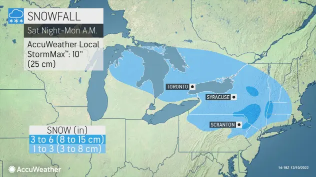
northern watch
TB Fanatic
From my email inbox The Old Farmer's Almanac December 11 2022

alpha
Veteran Member
Electroverse
Part one...
 Extreme Weather
Most recently (Dec 12), Yakutian –the cold pole of Oymyakon– has seen the mercury sink to -61C (-77.8F) — the coldest temperature in the Northern Hemisphere this wintry season–and very early for such a reading.
In fact, and even more impressively, this is Oymyakon’s coldest December temperature since 1984 (solar minimum of cycle 21), and also the second lowest December temperature in ALL of Russia (also since 1984).

[courtesy of @ThierryGooseBC on Twitter]
It’s been historically cold in Northern China, too.
Last month, the coldest temperatures since the 1980s disrupted the seasonal migration of nomadic herders in northwest China’s Xinjiang region.
The inclement conditions trapped many herders and froze thousands of livestock to death as blizzards and temperatures as low as a record-smashing -48.6C (-55.5F) descended from the north.

Serikzhan Bilash
@SerikzhanBilash
The sheep of the Kazakh herdsmen in Xinjiang all froze to death.The Xinjiang authorities systematically bankrupted Kazakh herders and forced them to abandon the grasslands, depriving the Kazakhs of the grasslands. https://t.co/9PyF4NVZyv

2:06 AM · Nov 24, 2022
The blast also froze at least seven Chinese construction workers at a project site in city of Altay.
Even the capital Beijing got in on the cold act, registering its lowest November temperature since 1970.
Looking ahead, the next 10 days are forecast to bring more of the same, perhaps even an intensification.
China will be hit by three cold waves with the the mercury across the nation on course to hold exceptionally low for an extended period of time. Northeast China will find itself in the center of the Arctic outbreak, with record-breaking temperatures of -50C (-58F) on the cards.
China, and indeed Russia, know what’s coming.
Their scientists have long-been warning about it…
Chinese Scientists warn of imminent Global Cooling

As a result of her research, Wu said she was now much more worried about global cooling than global warming…
 Electroverse
The Scottish glens plunged below -15C (5F) over the past few mornings, which, in record books dating back to the 1800s, makes it the UK’s lowest temperatures for Dec 11 and 12 on record, besting the 14.7C from 1967 and the 15C from 1981, respectively.
Needless to say, the MSM is refusing to touch the historical nature of the freeze, instead opting to focusing on aspects such the disruptive snow–which is also unseasonable, and the concerning energy implications–more on that later.
London, for example, rarely sees accumulating snow in December, let alone during the first half of the month, but this was the scene on Sunday evening across the capital:

Joyce Karam
@Joyce_Karam
London and Big Ben under the snow tonight. Just beautiful https://t.co/wbDMxMuKDo

6:11 PM · Dec 11, 2022
https://twitter.com/intent/like?ref...3840widget=Tweet&tweet_id=1602078654791843840

Chloe
@paintingsbycm
Foxes playing in the snow in London! #londonsnow https://t.co/6Kn6CeVd3u

6:14 PM · Dec 11, 2022
Brits have been conditioned to expect ever-milder winters thanks to ‘catastrophic anthropogenic global warming’, they are woefully unprepared for what’s really barreling down the pike.
TV pop-scientists told them the planet was warming uncontrollably, after all, and that nothing, not even a decrease in the Sun’s output, could possibly counter this.
The only course of action, the establishment decreed, was to drastically reduce ones living standards, via what amounts to a defunding of the fossil industry, in order to reduce CO2 output. This is genius in its malevolence, but in its malevolence only, because what it boils down to for the 99.9% is economic and prosperity suicide. Very few seem to acknowledge that. After all, when facing such as grave threat as ‘the end of the world’ all measures are on the table, no matter how anti-human or outright evil, right? Energy restrictions, “of course”; climate lockdowns, “whatever works”; a social credit score system, “if you think it’s best”. The masses have traded free-thought and autonomy for an easy life where everything is decided for them, and there is only-ever one way that’s going to go, and we’re seeing the beginnings of it now. If you fell for this scam, shame on you — truly. Your weak, lazy and fear-driven choices have doomed us all. This chimes with COVID, too. Your cowardice won’t be forgiven.
Snow was a thing of the past, right Britons?
The irony of these gaz-guzzling, Co2-spewing cars skidding about the ice isn’t lost:
continued...
Part one...
Russia Plunges To -61C (-77.8F); Record-Cold And Snow-Chaos Hit The UK, Sending Energy Prices To Unprecedented Highs; Sierra Slammed With Snow, More Threatens Central US; + Australia Busts 20+ Monthly Low Temperature Records
December 12, 2022 Cap AllonRussia Plunges To -61C (-77.8F)
It’s been historically cold across the majority of transcontinental Russia in recent weeks.Most recently (Dec 12), Yakutian –the cold pole of Oymyakon– has seen the mercury sink to -61C (-77.8F) — the coldest temperature in the Northern Hemisphere this wintry season–and very early for such a reading.
In fact, and even more impressively, this is Oymyakon’s coldest December temperature since 1984 (solar minimum of cycle 21), and also the second lowest December temperature in ALL of Russia (also since 1984).

[courtesy of @ThierryGooseBC on Twitter]
It’s been historically cold in Northern China, too.
Last month, the coldest temperatures since the 1980s disrupted the seasonal migration of nomadic herders in northwest China’s Xinjiang region.
The inclement conditions trapped many herders and froze thousands of livestock to death as blizzards and temperatures as low as a record-smashing -48.6C (-55.5F) descended from the north.
Serikzhan Bilash
@SerikzhanBilash
The sheep of the Kazakh herdsmen in Xinjiang all froze to death.The Xinjiang authorities systematically bankrupted Kazakh herders and forced them to abandon the grasslands, depriving the Kazakhs of the grasslands. https://t.co/9PyF4NVZyv
2:06 AM · Nov 24, 2022
The blast also froze at least seven Chinese construction workers at a project site in city of Altay.
Even the capital Beijing got in on the cold act, registering its lowest November temperature since 1970.
Looking ahead, the next 10 days are forecast to bring more of the same, perhaps even an intensification.
China will be hit by three cold waves with the the mercury across the nation on course to hold exceptionally low for an extended period of time. Northeast China will find itself in the center of the Arctic outbreak, with record-breaking temperatures of -50C (-58F) on the cards.
China, and indeed Russia, know what’s coming.
Their scientists have long-been warning about it…
Chinese Scientists warn of imminent Global Cooling
As a result of her research, Wu said she was now much more worried about global cooling than global warming…
Record-Cold And Snow-Chaos Hit The UK…
The UK has been enduring some truly anomalous early-season chills, with snow blanketing much all four home nations.The Scottish glens plunged below -15C (5F) over the past few mornings, which, in record books dating back to the 1800s, makes it the UK’s lowest temperatures for Dec 11 and 12 on record, besting the 14.7C from 1967 and the 15C from 1981, respectively.
Needless to say, the MSM is refusing to touch the historical nature of the freeze, instead opting to focusing on aspects such the disruptive snow–which is also unseasonable, and the concerning energy implications–more on that later.
London, for example, rarely sees accumulating snow in December, let alone during the first half of the month, but this was the scene on Sunday evening across the capital:
Joyce Karam
@Joyce_Karam
London and Big Ben under the snow tonight. Just beautiful
https://t.co/wbDMxMuKDo
6:11 PM · Dec 11, 2022
https://twitter.com/intent/like?ref...3840widget=Tweet&tweet_id=1602078654791843840
Chloe
@paintingsbycm
Foxes playing in the snow in London!
#londonsnow https://t.co/6Kn6CeVd3u
6:14 PM · Dec 11, 2022
Brits have been conditioned to expect ever-milder winters thanks to ‘catastrophic anthropogenic global warming’, they are woefully unprepared for what’s really barreling down the pike.
TV pop-scientists told them the planet was warming uncontrollably, after all, and that nothing, not even a decrease in the Sun’s output, could possibly counter this.
The only course of action, the establishment decreed, was to drastically reduce ones living standards, via what amounts to a defunding of the fossil industry, in order to reduce CO2 output. This is genius in its malevolence, but in its malevolence only, because what it boils down to for the 99.9% is economic and prosperity suicide. Very few seem to acknowledge that. After all, when facing such as grave threat as ‘the end of the world’ all measures are on the table, no matter how anti-human or outright evil, right? Energy restrictions, “of course”; climate lockdowns, “whatever works”; a social credit score system, “if you think it’s best”. The masses have traded free-thought and autonomy for an easy life where everything is decided for them, and there is only-ever one way that’s going to go, and we’re seeing the beginnings of it now. If you fell for this scam, shame on you — truly. Your weak, lazy and fear-driven choices have doomed us all. This chimes with COVID, too. Your cowardice won’t be forgiven.
Snow was a thing of the past, right Britons?
The irony of these gaz-guzzling, Co2-spewing cars skidding about the ice isn’t lost:
continued...
alpha
Veteran Member
Electroverse
Part two...

Urban Pictures
@Urban_Pictures
Vehicles crash & motorists abandon cars as heavy snow hits Gloucestershire. Motorists were involved in crashes as heavy snow hit the Southwest today (Dec 11). Footage taken at Leckhampton Hill in Cheltenham shows motorists struggling to cope. #Gloucestershire #Cheltenham #snow https://t.co/DmunMaPrCg

12:12 PM · Dec 11, 2022
The snow was much heavier in the north, as you might expect.
So heavy, in fact, that four walkers in the Scottish Mountains had to be rescued after they encountered “waist deep” snow.
The UK has not prepared its citizens for what’s coming…

josh
@can_cagzimm
M25 no salt nothing on essex side! @BBCBreaking @LBC @NickFerrariLBC @MayorofLondon #londonsnow #m25 #snow https://t.co/vU985rfefp

5:05 PM · Dec 11, 2022
…the lights (and heating) will soon go off, soon; if not this year, then next–at least this is what the energy CEOs are warning us.

Micheala Cronin
@MichealaCronin
Please can someone update us as to how long we will be stuck? I am low petrol now and can’t heat the car and I have a child. This is really scary. Never seen anything like this and Iv not seen any emergency services. #m25 #news #bbcnews #snow https://t.co/Xa9goIiZ6o

6:55 PM · Dec 11, 2022
Cold kills 20x as many people than heat, according to a recent study published in The Lancet, with that figure shown to be 80x as per other research. While a 2020 study in the U.S. concluded that patients who died of the cold were responsible for 94% of all temperature-related deaths.
Prepare.
Live data from the National Grid showed that wind was providing just 3% of Britain’s electricity generation on Sunday, with gas-fired power stations providing 59%, and nuclear and imports accounting for about 15%.
The day-ahead price settled at a record £674.78 a megawatt-hour on the Epex Spot SE exchange with the price for 5-6 p.m. clearing at an all-time high of £2585.80 a megawatt-hour, as the Met Office extended weather warnings for snow and ice throughout the UK.
Prices are surging as an unseasonably-fierce Arctic outbreak forces Britons to increase their heating usage, pushing up demand for energy –despite record-high bills– and running down the country’s reserves far earlier than expected.
This is the story across Europe, too.
Authorities across the EU say they have enough gas in the tanks to stave off an ‘average’ winter, but this one is looking far from normal as the continent braces for its second disruptive polar blast in as many weeks:

GFS 2m Temperature Anomalies for Dec 13 [tropicaltidbits.com].
Note, for me in on the Iberian Peninsula, things continue to hold mild–albeit very wet and windy.
Myself and my young family are living off-grid in Central Portugal, growing our own food etc. We run all of our power needs off our 5000W solar setup, but do have a back-up generator in case of a failure. However, the generator failed over the weekend, and so I traveled to our closest city to replace it.
But no luck.
Apparently, a massive order was put in last week, destined for the Ukraine.
Very well, so be it, the Ukrainian’s no doubt need them more than me. But still, I can’t help but think this is another turning of the screw for the average citizen; more specifically, that faceless, unelected forces above our heads continue to negatively impact our ability to properly prepare for what’s coming.
I don’t know…
An overnight low of 40F was forecast for San Francisco, with the mercury forecast to plunge lower Tuesday.
A freeze watch is in effect from late Monday through Tuesday morning in the North Bay valleys, encompassing Santa Rosa and the Napa Valley. Overnight it could sink to the mid-20s
The National Weather Service warned of “difficult to impossible” travel conditions throughout the Sierra, with whiteout conditions, major travel delays and chain controls and road closures likely.

The Placer County sheriff’s North Lake Tahoe station is buried in snow Saturday.
The latest GFS run (shown below) reveals the snowiest spots, which currently look set to be eastern Montana, the Dakotas, northern Nebraska and Minnesota. The Northeast also won’t be spared, with another dumping of early-season snow set to follow the historic 6+ feet that clipped the likes of Buffalo last month.

GFS Total Snowfall (inches) Dec 12 – Dec 28 [tropicaltidbits.com].
Some the standouts included Dunedoo’s 1.2C (34.2F), Bairnsdale Airport’s 3C (37.4F) and Grenfell’s 3.5C (38.3F).
The Dunedoo value is particularly impressive, besting the previous December record (1965) by 2.6C.
Looking ahead, the south’s chill won’t abate anytime soon:

GFS 2m Temperature Anomalies (C) for Dec 13 [tropicaltidbits.com].

GFS 2m Temperature Anomalies (C) for Dec 15 [tropicaltidbits.com].

GFS 2m Temperature Anomalies (C) for Dec 25 [tropicaltidbits.com].
Much of the planet is holding unusually-cold.
Taking the Northern Hemisphere, polar air is being displaced and funneled south, with the Arctic itself now holding mild.
This is fully expected during –and explained by– extended periods of low solar activity (such as the historically low output we’re receiving now), but be on watch for MSM obfuscation: “Look, the Arctic is XX-degrees above average, think of the polar bears!” the activist-scientists will cry, as us humans at the lower latitudes struggle to heat our homes due an entirely avoidable energy crisis arriving simultaneously with a cyclically-returning bout of COOLING (…coincidence…).
And then next year, when the issue is ten-times worse and there is no energy left to ration, what do these murderous puppets of the controlled-destructors suggest we do then? Move to an anomalously-mild Arctic? Or will it be the case these traitors to humanity have already been tossed to us proles and lynched by then? Not a suggestion, by the way — just a question…
Part two...
Urban Pictures
@Urban_Pictures
Vehicles crash & motorists abandon cars as heavy snow hits Gloucestershire. Motorists were involved in crashes as heavy snow hit the Southwest today (Dec 11). Footage taken at Leckhampton Hill in Cheltenham shows motorists struggling to cope. #Gloucestershire #Cheltenham #snow https://t.co/DmunMaPrCg
12:12 PM · Dec 11, 2022
The snow was much heavier in the north, as you might expect.
So heavy, in fact, that four walkers in the Scottish Mountains had to be rescued after they encountered “waist deep” snow.
The UK has not prepared its citizens for what’s coming…
josh
@can_cagzimm
M25 no salt nothing on essex side! @BBCBreaking @LBC @NickFerrariLBC @MayorofLondon #londonsnow #m25 #snow https://t.co/vU985rfefp
5:05 PM · Dec 11, 2022
…the lights (and heating) will soon go off, soon; if not this year, then next–at least this is what the energy CEOs are warning us.
Micheala Cronin
@MichealaCronin
Please can someone update us as to how long we will be stuck? I am low petrol now and can’t heat the car and I have a child. This is really scary. Never seen anything like this and Iv not seen any emergency services. #m25 #news #bbcnews #snow https://t.co/Xa9goIiZ6o
6:55 PM · Dec 11, 2022
Cold kills 20x as many people than heat, according to a recent study published in The Lancet, with that figure shown to be 80x as per other research. While a 2020 study in the U.S. concluded that patients who died of the cold were responsible for 94% of all temperature-related deaths.
Prepare.
…Sending Energy Prices To Unprecedented Highs
UK power prices jumped to record levels on Monday as freezing temperatures cause a surge in demand, just as a drop in wind generation compounds a supply crunch.Live data from the National Grid showed that wind was providing just 3% of Britain’s electricity generation on Sunday, with gas-fired power stations providing 59%, and nuclear and imports accounting for about 15%.
The day-ahead price settled at a record £674.78 a megawatt-hour on the Epex Spot SE exchange with the price for 5-6 p.m. clearing at an all-time high of £2585.80 a megawatt-hour, as the Met Office extended weather warnings for snow and ice throughout the UK.
Prices are surging as an unseasonably-fierce Arctic outbreak forces Britons to increase their heating usage, pushing up demand for energy –despite record-high bills– and running down the country’s reserves far earlier than expected.
This is the story across Europe, too.
Authorities across the EU say they have enough gas in the tanks to stave off an ‘average’ winter, but this one is looking far from normal as the continent braces for its second disruptive polar blast in as many weeks:

GFS 2m Temperature Anomalies for Dec 13 [tropicaltidbits.com].
Note, for me in on the Iberian Peninsula, things continue to hold mild–albeit very wet and windy.
Myself and my young family are living off-grid in Central Portugal, growing our own food etc. We run all of our power needs off our 5000W solar setup, but do have a back-up generator in case of a failure. However, the generator failed over the weekend, and so I traveled to our closest city to replace it.
But no luck.
Apparently, a massive order was put in last week, destined for the Ukraine.
Very well, so be it, the Ukrainian’s no doubt need them more than me. But still, I can’t help but think this is another turning of the screw for the average citizen; more specifically, that faceless, unelected forces above our heads continue to negatively impact our ability to properly prepare for what’s coming.
I don’t know…
Sierra Slammed With Snow…
Roads remain closed and conditions dangerous as a winter storm that slammed the Sierra continued Sunday, with low temperatures and freeze watches extended into the new week, and another 2-feet of snow expected overnight Sunday alone.An overnight low of 40F was forecast for San Francisco, with the mercury forecast to plunge lower Tuesday.
A freeze watch is in effect from late Monday through Tuesday morning in the North Bay valleys, encompassing Santa Rosa and the Napa Valley. Overnight it could sink to the mid-20s
The National Weather Service warned of “difficult to impossible” travel conditions throughout the Sierra, with whiteout conditions, major travel delays and chain controls and road closures likely.

The Placer County sheriff’s North Lake Tahoe station is buried in snow Saturday.
…More Threatens Central US
The Sierra snowstorm is now making its way to east, already dropping heavy snow to the north-Central U.S. and bringing severe storms to the South.The latest GFS run (shown below) reveals the snowiest spots, which currently look set to be eastern Montana, the Dakotas, northern Nebraska and Minnesota. The Northeast also won’t be spared, with another dumping of early-season snow set to follow the historic 6+ feet that clipped the likes of Buffalo last month.

GFS Total Snowfall (inches) Dec 12 – Dec 28 [tropicaltidbits.com].
Australia Busts 20+ Monthly Low Temperature Records
Australia’s most-recent cold spell, which follows a colder-than-average-winter, spring and the country’s lowest summer temperature ever recorded, produced at least 20 monthly low temperature records over a just a 2-day period.Some the standouts included Dunedoo’s 1.2C (34.2F), Bairnsdale Airport’s 3C (37.4F) and Grenfell’s 3.5C (38.3F).
The Dunedoo value is particularly impressive, besting the previous December record (1965) by 2.6C.
Looking ahead, the south’s chill won’t abate anytime soon:

GFS 2m Temperature Anomalies (C) for Dec 13 [tropicaltidbits.com].

GFS 2m Temperature Anomalies (C) for Dec 15 [tropicaltidbits.com].

GFS 2m Temperature Anomalies (C) for Dec 25 [tropicaltidbits.com].
Much of the planet is holding unusually-cold.
Taking the Northern Hemisphere, polar air is being displaced and funneled south, with the Arctic itself now holding mild.
This is fully expected during –and explained by– extended periods of low solar activity (such as the historically low output we’re receiving now), but be on watch for MSM obfuscation: “Look, the Arctic is XX-degrees above average, think of the polar bears!” the activist-scientists will cry, as us humans at the lower latitudes struggle to heat our homes due an entirely avoidable energy crisis arriving simultaneously with a cyclically-returning bout of COOLING (…coincidence…).
And then next year, when the issue is ten-times worse and there is no energy left to ration, what do these murderous puppets of the controlled-destructors suggest we do then? Move to an anomalously-mild Arctic? Or will it be the case these traitors to humanity have already been tossed to us proles and lynched by then? Not a suggestion, by the way — just a question…
northern watch
TB Fanatic


TxGal
Day by day
Looks to make its way up the eastern seaboard and be a Nor'easter after it pummels the southern states.
alpha
Veteran Member
Electroverse

Articles
On December 13 and 14, 2009 professor, prophet and soothsayer Al Gore predicted the North Polar Ice Cap could be completely ice free within the next five to seven years.
Gore made his prediction at COP15 Copenhagen –which ran from Dec 7 to Dec 18, 2009– where he repeatedly referenced “state-of-the-art” computer modeling to suggest that the north polar ice cap may lose all of its ice by 2014.
“Some of the models suggest that there is a 75 percent chance that the entire north polar ice cap, during some of the summer months, could be completely ice-free within the next five to seven years,” Gore claimed.
“Join me in asking president Obama and the US Senate to set a deadline of 22 April for final action in the US Senate. I do not believe we can wait till next November or December.”
The Guardian wrote on Dec 16, 2009, in an article entitled “Al Gore rallies the troops in Copenhagen“:
“[Gore] kept up the pace by calling for the international community to sign up to a fully fledged climate change treaty by July 2010 – and then announcing that Mexico was prepared to host a deal-making summit.
“He scolded rich countries for demanding the developing world offer evidence of emissions cuts while at the same time trying to inflate the funds they were prepared to offer poor countries to deal with climate change. And he was just as tough on activists who have embraced him as a hero, demanding they set aside their pride and their principles and embrace a deal – no matter how imperfect. He said he recognized their frustration with the glacial pace of negotiations. He agreed that cap-and-trade schemes to cut carbon emissions were an imperfect solution – Gore confessed to favoring a carbon tax – but the current efforts for a deal were the best prospect of avoiding catastrophic climate change.
“And there was no trace of sympathy for opponents of action on climate change. Gore began with a brief run-through of the latest science on melting of the Arctic ice cap, evidence he said “only reckless fools would ignore.”“
Well, who’s the fool now…
The summer of 2022 saw impressive ice thickness/extent across the Arctic region.
According to the Danish Meteorological Institute (DMI), at its lowest point (mid-Sept) Arctic sea ice volume held at around 6,500km3. This is well within the normal range, and also comfortably above 2019, 2020 and 2021.
Eight years on from Al’s doomsday date, summer ice is not only still with us, but growing.
Moreover, Greenland is gaining mass at a record-breaking rate this season (in books dating back to 1981):
Electroverse
@Electroversenet
Now I don't mean to be a #ClimateCrisis party pooper, but Greenland's SMB --a calculation used to determine the 'health' of a glacier-- has never been higher in books dating back to 1981. In other words, the Ice Sheet has never-before gained so much mass this early into a season: https://t.co/9NUV2MRcp6
5:49 AM · Dec 5, 2022
Instead of graciously admitting defeat, however, the AGW Party continues to simply extend its ‘countdown to catastrophe’, and the climate-alarmists, activist-scientists and lapdog-of-an-MSM continue to turn a blind eye to their ruse.
In 2018 they gave us another 12 years before ‘climate breakdown’:

Greenpeace PressDesk
@greenpeacepress
"We have 12 years to save the world. Don’t waste this year." #COP24 https://t.co/NguPlcNiMf

5:46 AM · Dec 13, 2018
And now that that deadline is looking a little ambitious, we have a new prophesy, or rather, prophesies — there seems to be a fresh countdown added each week by some corrupted, non-profit entity which has resulted in a ‘confusion of clocks’:
The latest IPCC report gives 2025 as a hard deadline to get emissions under control; Concordia University’s Climate Clock (it’s actual name) suggests we have at least 10 years to stay within 1.5C of warming; while the Carbon Clock at the Mercator Research Institute on Global Commons and Climate Change still has a quarter of a century left to run.
Needless to say, these deadlines –along with all those that came and went before it– are unscientific, agenda-driving drivel.
What most alarmist fail to realize is how incredibly complex Earth’s climate system is. The margins for error in the IPCC’s own models are truly immense. How they can even attempt to tell us anything with any certainty based on those models is the joke.
The IPCC was created by the UN for the sole purpose of pushing its AGW agenda; and no real world observations, no matter how contradictory to that agenda, will get in the way.
Just look at past narrative shifts as the real world observations altered. We’re now to believe a catastrophically warming world also means more record snow and more record cold, not less as was previously prophesied.
But reality is fast catching up with these politicized bodies, and real world observations are soon to become insurmountable: The Sun is shutting down (relatively); cloud cover is increasing; as is volcanic activity; all four magnetic fields could be going out of phase; and La Niñas are becoming the dominant ENSO pattern — the upshot of all this will be undeniable global cooling.
Prepare.
Articles
Thirteen Years Ago Today, Al Gore Predicted The North Pole Would Be “Completely Ice Free Within The Next Five Years”
December 13, 2022 Cap AllonOn December 13 and 14, 2009 professor, prophet and soothsayer Al Gore predicted the North Polar Ice Cap could be completely ice free within the next five to seven years.
Gore made his prediction at COP15 Copenhagen –which ran from Dec 7 to Dec 18, 2009– where he repeatedly referenced “state-of-the-art” computer modeling to suggest that the north polar ice cap may lose all of its ice by 2014.
“Some of the models suggest that there is a 75 percent chance that the entire north polar ice cap, during some of the summer months, could be completely ice-free within the next five to seven years,” Gore claimed.
“Join me in asking president Obama and the US Senate to set a deadline of 22 April for final action in the US Senate. I do not believe we can wait till next November or December.”
The Guardian wrote on Dec 16, 2009, in an article entitled “Al Gore rallies the troops in Copenhagen“:
“[Gore] kept up the pace by calling for the international community to sign up to a fully fledged climate change treaty by July 2010 – and then announcing that Mexico was prepared to host a deal-making summit.
“He scolded rich countries for demanding the developing world offer evidence of emissions cuts while at the same time trying to inflate the funds they were prepared to offer poor countries to deal with climate change. And he was just as tough on activists who have embraced him as a hero, demanding they set aside their pride and their principles and embrace a deal – no matter how imperfect. He said he recognized their frustration with the glacial pace of negotiations. He agreed that cap-and-trade schemes to cut carbon emissions were an imperfect solution – Gore confessed to favoring a carbon tax – but the current efforts for a deal were the best prospect of avoiding catastrophic climate change.
“And there was no trace of sympathy for opponents of action on climate change. Gore began with a brief run-through of the latest science on melting of the Arctic ice cap, evidence he said “only reckless fools would ignore.”“
Well, who’s the fool now…
The summer of 2022 saw impressive ice thickness/extent across the Arctic region.
According to the Danish Meteorological Institute (DMI), at its lowest point (mid-Sept) Arctic sea ice volume held at around 6,500km3. This is well within the normal range, and also comfortably above 2019, 2020 and 2021.
Eight years on from Al’s doomsday date, summer ice is not only still with us, but growing.
Moreover, Greenland is gaining mass at a record-breaking rate this season (in books dating back to 1981):
Electroverse
@Electroversenet
Now I don't mean to be a #ClimateCrisis party pooper, but Greenland's SMB --a calculation used to determine the 'health' of a glacier-- has never been higher in books dating back to 1981. In other words, the Ice Sheet has never-before gained so much mass this early into a season: https://t.co/9NUV2MRcp6
5:49 AM · Dec 5, 2022
Instead of graciously admitting defeat, however, the AGW Party continues to simply extend its ‘countdown to catastrophe’, and the climate-alarmists, activist-scientists and lapdog-of-an-MSM continue to turn a blind eye to their ruse.
In 2018 they gave us another 12 years before ‘climate breakdown’:
Greenpeace PressDesk
@greenpeacepress
"We have 12 years to save the world. Don’t waste this year." #COP24 https://t.co/NguPlcNiMf
5:46 AM · Dec 13, 2018
And now that that deadline is looking a little ambitious, we have a new prophesy, or rather, prophesies — there seems to be a fresh countdown added each week by some corrupted, non-profit entity which has resulted in a ‘confusion of clocks’:
The latest IPCC report gives 2025 as a hard deadline to get emissions under control; Concordia University’s Climate Clock (it’s actual name) suggests we have at least 10 years to stay within 1.5C of warming; while the Carbon Clock at the Mercator Research Institute on Global Commons and Climate Change still has a quarter of a century left to run.
Needless to say, these deadlines –along with all those that came and went before it– are unscientific, agenda-driving drivel.
What most alarmist fail to realize is how incredibly complex Earth’s climate system is. The margins for error in the IPCC’s own models are truly immense. How they can even attempt to tell us anything with any certainty based on those models is the joke.
The IPCC was created by the UN for the sole purpose of pushing its AGW agenda; and no real world observations, no matter how contradictory to that agenda, will get in the way.
Just look at past narrative shifts as the real world observations altered. We’re now to believe a catastrophically warming world also means more record snow and more record cold, not less as was previously prophesied.
But reality is fast catching up with these politicized bodies, and real world observations are soon to become insurmountable: The Sun is shutting down (relatively); cloud cover is increasing; as is volcanic activity; all four magnetic fields could be going out of phase; and La Niñas are becoming the dominant ENSO pattern — the upshot of all this will be undeniable global cooling.
Prepare.
desertvet2
Veteran Member
They indeed had 12 years...
12 years to implement the taxation scheme to fund their giant underground bases as they are built.
To ensure that the best of the best have a chance of repopulating the surface after the next freeze/thaw cycle .
Why do you think they have the seed vaults and dumbs?
Pods for incubating humans, dna advancements, off planet survival systems..
So much of what is really going on escapes humanity as a whole.
alpha
Veteran Member
Electroverse
 Extreme Weather
Guadeloupe, for example, has experienced a had a very cool beginning to December. From the 1st to the 10th, the island’s international Airport Le Raizet has registered its coldest start to any month in at least 30 years.
Meanwhile in Martinique on Sunday, the low of 12.1C (53.8F) logged at Morne-Rouge/Champflore is now the lowest temperature ever recorded on the island, besting the 12.6C (54.7F) set during the January of 1975 (solar minimum of cycle 20).
Turning to South America, November in both Brazil and Paraguay finished colder-than-average.
For Brazil, it was particularly chilly across the eastern half of the country; while in Paraguay, it anomalously-cold across the country, with temperature minimums ranging from 1C and 2C below the multidecadal norm.

Australia has been at it again.
Following the nation’s colder-than-average winter, spring and now start to summer (which included Australia’s lowest summer temp ever recorded), another nine December cold benchmarks have been busted this morning (Dec 14).
The most impressive was the -5.4C (22.3F) set at Mt. Hotham, a reading which felled the State of Victoria’s lowest December (and summer) temperature ever recorded, the -5.2C (22.6F) from Dec 20, 1978 (solar minimum of cycle 20).
Gabo Island is also worth a mention.
It reached 6.1C (43F) this morning, which bests an even-longer standing record than Hotham.

Ben Domensino
@Ben_Domensino
NEW SUMMER RECORD > Mount Hotham's -5.4ºC this morning was Victoria's lowest summer temperature on record, beating -5.2ºC from the same place in December 1978. More details: Waterspouts form near tornado-hit town https://t.co/WXlZoguBgk

7:12 PM · Dec 13, 2022
The AGW Party is keen to blame Australia’s persistent and historic cold on a rare third-consecutive La Niña. Fair enough. But what they fail to mention is that their global warming hypothesis decreed El Niño to be the dominant ENSO pattern moving forward.
La Niñas, on the other hand, are tied to planetary cooling.
This real-world observation shocked the climate modelers, who themselves admit they are now scrambling for answers:
The mercury plunged to -15.7C (3.7F) in Braemar, Scotland on the morning of Dec 12; one of the lowest mid-December temperatures ever recorded in books dating back to the 1800s.
The same location sank even lower the following morning, registering an astonishing -17.3C (0.9F) — a reading the AGW Party genuinely claimed would be an impossibility by now.
The days didn’t warm up much, either. Braemar struggled to just -9.3C (15.3F) on Monday; the UK’s lowest maximum since the historically-cold readings (again in books dating back to the 1800s) suffered during the December of 2010.

Met Office
@metoffice
️ It's provisionally been the coldest day in the UK since December 2010 Today's highest temperature recorded in Braemar, Aberdeenshire is minus 9.3 Celsius Assuming temperatures don't rise overnight, this will be the lowest maximum temperature recorded in the UK for 12 years https://t.co/r2eQZE2WrR

11:41 AM · Dec 12, 2022
The country’s rare December snow is also proving disruptive.

Gurbaksh Singh Chahal
@gchahal
WATCH: #BNNUK Reports The United Kingdom's schools were closed for the second day in a row as the country faced another day of snow and ice. As an Arctic freeze engulfed the #UK yesterday, thousands of classrooms were closed, with children working remotely. #London https://t.co/eqo8zEu56W

3:23 AM · Dec 14, 2022
While across Europe, the mercury has been plunging there, too, draining gas reserves far-quicker than hoped.
Switzerland, for example, suffered -27C (-16.6F) this week, in Ofen Pass, Graubünden.

MeteoNews Schweiz
@MeteoNewsAG
Das sind die 8 kältesten Messorte aus dem offiziellen Schweizer Messnetz. Angeführt wird die Liste von #Buffalora mit -27 Grad. Historisch #kalt war die Nacht allerdings nicht, Rekordwerte waren ausser Reichweite. Die Einordnung gibt es unter MeteoNews: Erster Schnee bis in tiefe Lagen, danach teils strenger Frost (5. Dezember 2022) (rv) https://t.co/Qo3r7H6tfN

2:04 AM · Dec 12, 2022
Both Europe’s balmy summer heat and now ferocious December freeze can be FULLY explained by a low solar activity-induced meridional jet stream flow — no world-reshaping, CO2-driven ‘climate scam’ required.
For more:
Summer Frosts In The Highlands Of Portugal & Spain, As Record Heat Sweeps Italy: Low Solar Activity & A ‘Meridional’ Jet Stream, Explained
The AGW hypothesis can confidently explain Central Europe’s heatwave; but it fails when it comes to Western Europe’s simultaneous summer freeze. A new theory is needed: ‘low solar activity’.
And eyeing the latest GFS run (shown below), another truly frigid blast of polar air is on the way, due to invade the West initially, but with Central and Eastern provinces/states on course to cop the worst of it over the weekend and throughout next week:

GFS 2m Temperature Anomalies (C) Dec 17 – Dec 25 [tropicaltidbits.com].
The freeze is forecast to deliver temperatures some -30C below the seasonal norm.
It will also be accompanied by heavy, likely record-breaking snow:

GFS Total Snowfall (inches) Dec 14 – Dec 30 [tropicaltidbits.com].

GFS Total Snowfall (inches) Dec 14 – Dec 30 [tropicaltidbits.com].
This isn’t hyperbole, North Americans; if the forecast holds true, this will prove a disruptive, life-threatening cold event, and one arriving smack-bang in the middle of the holidays, too.
Prepare.
Record Cold Caribbeans; Colder-Than-Average Novembers For Brazil And Paraguay; State Of Victoria Just Set Its Coldest Summer Temp Ever; UK Freeze Breaks Records; + Ferocious Arctic Blast On Course To Slam U.S.
December 14, 2022 Cap AllonRecord Cold Caribbeans
It’s been holding cold across much of The Caribbean of late.Guadeloupe, for example, has experienced a had a very cool beginning to December. From the 1st to the 10th, the island’s international Airport Le Raizet has registered its coldest start to any month in at least 30 years.
Meanwhile in Martinique on Sunday, the low of 12.1C (53.8F) logged at Morne-Rouge/Champflore is now the lowest temperature ever recorded on the island, besting the 12.6C (54.7F) set during the January of 1975 (solar minimum of cycle 20).
Colder-Than-Average Novembers For Brazil And Paraguay
Turning to South America, November in both Brazil and Paraguay finished colder-than-average.For Brazil, it was particularly chilly across the eastern half of the country; while in Paraguay, it anomalously-cold across the country, with temperature minimums ranging from 1C and 2C below the multidecadal norm.

State Of Victoria Just Set Its Coldest Summer Temp Ever
Australia has been at it again.Following the nation’s colder-than-average winter, spring and now start to summer (which included Australia’s lowest summer temp ever recorded), another nine December cold benchmarks have been busted this morning (Dec 14).
The most impressive was the -5.4C (22.3F) set at Mt. Hotham, a reading which felled the State of Victoria’s lowest December (and summer) temperature ever recorded, the -5.2C (22.6F) from Dec 20, 1978 (solar minimum of cycle 20).
Gabo Island is also worth a mention.
It reached 6.1C (43F) this morning, which bests an even-longer standing record than Hotham.
Ben Domensino
@Ben_Domensino
NEW SUMMER RECORD > Mount Hotham's -5.4ºC this morning was Victoria's lowest summer temperature on record, beating -5.2ºC from the same place in December 1978. More details: Waterspouts form near tornado-hit town https://t.co/WXlZoguBgk
7:12 PM · Dec 13, 2022
The AGW Party is keen to blame Australia’s persistent and historic cold on a rare third-consecutive La Niña. Fair enough. But what they fail to mention is that their global warming hypothesis decreed El Niño to be the dominant ENSO pattern moving forward.
La Niñas, on the other hand, are tied to planetary cooling.
This real-world observation shocked the climate modelers, who themselves admit they are now scrambling for answers:
UK Freeze Breaks Records
It’s been holding exceptionally cold across the UK over the past 10-or-so days.The mercury plunged to -15.7C (3.7F) in Braemar, Scotland on the morning of Dec 12; one of the lowest mid-December temperatures ever recorded in books dating back to the 1800s.
The same location sank even lower the following morning, registering an astonishing -17.3C (0.9F) — a reading the AGW Party genuinely claimed would be an impossibility by now.
The days didn’t warm up much, either. Braemar struggled to just -9.3C (15.3F) on Monday; the UK’s lowest maximum since the historically-cold readings (again in books dating back to the 1800s) suffered during the December of 2010.
Met Office
@metoffice
️ It's provisionally been the coldest day in the UK since December 2010 Today's highest temperature recorded in Braemar, Aberdeenshire is minus 9.3 Celsius Assuming temperatures don't rise overnight, this will be the lowest maximum temperature recorded in the UK for 12 years https://t.co/r2eQZE2WrR
11:41 AM · Dec 12, 2022
The country’s rare December snow is also proving disruptive.
Gurbaksh Singh Chahal
@gchahal
WATCH: #BNNUK Reports The United Kingdom's schools were closed for the second day in a row as the country faced another day of snow and ice. As an Arctic freeze engulfed the #UK yesterday, thousands of classrooms were closed, with children working remotely. #London https://t.co/eqo8zEu56W
3:23 AM · Dec 14, 2022
While across Europe, the mercury has been plunging there, too, draining gas reserves far-quicker than hoped.
Switzerland, for example, suffered -27C (-16.6F) this week, in Ofen Pass, Graubünden.
MeteoNews Schweiz
@MeteoNewsAG
Das sind die 8 kältesten Messorte aus dem offiziellen Schweizer Messnetz. Angeführt wird die Liste von #Buffalora mit -27 Grad. Historisch #kalt war die Nacht allerdings nicht, Rekordwerte waren ausser Reichweite. Die Einordnung gibt es unter MeteoNews: Erster Schnee bis in tiefe Lagen, danach teils strenger Frost (5. Dezember 2022) (rv) https://t.co/Qo3r7H6tfN
2:04 AM · Dec 12, 2022
Both Europe’s balmy summer heat and now ferocious December freeze can be FULLY explained by a low solar activity-induced meridional jet stream flow — no world-reshaping, CO2-driven ‘climate scam’ required.
For more:
Summer Frosts In The Highlands Of Portugal & Spain, As Record Heat Sweeps Italy: Low Solar Activity & A ‘Meridional’ Jet Stream, Explained
The AGW hypothesis can confidently explain Central Europe’s heatwave; but it fails when it comes to Western Europe’s simultaneous summer freeze. A new theory is needed: ‘low solar activity’.
Ferocious Arctic Blast On Course To Slam U.S.
It’s been incredibly cold and snowy across the pond, too, in North America.And eyeing the latest GFS run (shown below), another truly frigid blast of polar air is on the way, due to invade the West initially, but with Central and Eastern provinces/states on course to cop the worst of it over the weekend and throughout next week:

GFS 2m Temperature Anomalies (C) Dec 17 – Dec 25 [tropicaltidbits.com].
The freeze is forecast to deliver temperatures some -30C below the seasonal norm.
It will also be accompanied by heavy, likely record-breaking snow:

GFS Total Snowfall (inches) Dec 14 – Dec 30 [tropicaltidbits.com].

GFS Total Snowfall (inches) Dec 14 – Dec 30 [tropicaltidbits.com].
This isn’t hyperbole, North Americans; if the forecast holds true, this will prove a disruptive, life-threatening cold event, and one arriving smack-bang in the middle of the holidays, too.
Prepare.
northern watch
TB Fanatic
Extremely cold air from Siberia will send US into deep freeze days before Christmas
A bitter blast of cold air will challenge records that have stood since the 1980s from the northern Rockies to the Southeast, as well as stress energy grids, in the run up to the Christmas holiday.By Bill Deger, AccuWeather senior meteorologist
Published Dec. 14, 2022 1:18 PM EST | Updated Dec. 14, 2022 3:02 PM EST


Last edited:
northern watch
TB Fanatic
RT: 0.11 minutes
northern watch
TB Fanatic

One do not know what to make of the above photo, a homeless person trying to stay warm with a blanket and sitting on a piece of cardboard?
If that is the case, then the person will not survive the winter.
Last edited:
northern watch
TB Fanatic
From my email inbox The Old Farmer's Almanac December 14 2022

alpha
Veteran Member
Electroverse

Extreme Weather
Temperatures had plunged to -43.4C (-46.1F) on the Greater Hinggan Mountain yesterday evening, with thermometers expected to continue dropping overnight, to perhaps a record-busting -50C (-58F) by morning.
The polar air is now traversing south, into the tropics.
Xinfeng, for example, in Guangdong Province (23.9N), logged -3C (26.6F), the locale’s lowest temperature in 23 years — with more to come.
As reported yesterday (linked below), record cold has swept The Caribbean this week.
The highlands of Hispaniola Island have now also joined in the fun.
The station of Valle Nuevo in the Dominican Republic recently sank to 1.9C (35.4F). This is the country’s lowest temperature ever recorded in the month of December, and the lowest in any month for almost 50 years.
“We had a good drift of snow this morning, but it’s very surreal,” said Jindabyne local Olivier Kapetanakos. “[It’s] not normal”.
Areas like Perisher Valley, Thredbo Village, Charlotte Pass and Selwyn have all seen summer snow this week, with more, as well as sub-zero lows (C), forecast to continue for the foreseeable, as a ‘blocking’ weather pattern prevents warm air from returning to Australia’s southern shore — a pattern that becomes more prevalent during times of low solar activity, such as the historically low output we’ve been receiving since solar cycle 24 (so around 2008).

Charlotte Pass, NSW.

Snow has even fallen in Delegate on the border between NSW and Victoria [Angus Hobson].
And while the snow is undoubtedly impressive, and at times unprecedented, it is the cold that’s the real story here. This is the view of MountainWatch.com‘s Reggae Elliss, who said: “It’s not run of the mill stuff because of the length of time we’re seeing with this period of cold weather.”
The intensity of the freeze is also jaw-dropping…
More cold records from were set this morning, Thursday, December 15 — at least another dozen.
Of the 12 locales that set new monthly low temperature, the standouts are probably Cobar with its 8C (46.4F), Trangie with 6.2C (43.2), and Glen Innes with its truly frigid -1.7C (28.9F)–which is also a new ‘summer’ record low.
Australia has broken almost 100 monthly cold-records so far this December, including Victoria’s -5.4C (22.3F) — the state’s lowest summer temperature ever; and Perisher’s (-7C/19.4F) — the entire Aussie continent’s coldest summer temperature ever recorded.
NOAA forecasters say there is a 75% chance of M-flares and a 15% chance of X-flares today, Dec 15. And with 11 numbered sunspot groups crossing the face of the sun, odds are good that any eruption will be geoeffective (impact Earth).
Yesterday, fast-growing sunspot AR3165 unleashed a remarkable series of M-class solar flares.
All day long, no more than a few hours went by without a significant explosion:

Fortunately, while the sunspot strobed Earth with more than 10 pulses of extreme ultraviolet and X-radiation –which caused shortwave radio blackouts across all longitudes, impacting aviators and mariners using frequencies below 15 MHz– preliminary coronagraph data from SOHO suggests that all of these M-flares will miss Earth.
Maybe next time?
Dr Tony Phillips, of spaceweather.com, points to another large sunspot, ‘AR3163’, which also has unstable ‘beta-gamma’ magnetic field. Such a field poses a threat for M-and-maybe-X-class flares–and it is directly facing Earth:

Sunspots AR3163 and AR3165 have unstable ‘beta-gamma’ magnetic fields that harbor energy for Earth-directed flares. [SDO/HMI]
Stay tuned for updates.
Extreme Weather
China Approaches -50C (-58F); Record Cold In The Dominican Republic; Summer Snow Down Under, Another 12 *Monthly* Low Temp Records Felled; + The Sun Is Crackling With M-Flares
December 15, 2022 Cap AllonChina Approaches -50C (-58F)
China’s lingering –and already record-breaking– freeze has intensified again this week, with Northern provinces in the grips of yet another fierce Arctic Outbreak.Temperatures had plunged to -43.4C (-46.1F) on the Greater Hinggan Mountain yesterday evening, with thermometers expected to continue dropping overnight, to perhaps a record-busting -50C (-58F) by morning.
The polar air is now traversing south, into the tropics.
Xinfeng, for example, in Guangdong Province (23.9N), logged -3C (26.6F), the locale’s lowest temperature in 23 years — with more to come.
Record Cold In The Dominican Republic
As reported yesterday (linked below), record cold has swept The Caribbean this week.The highlands of Hispaniola Island have now also joined in the fun.
The station of Valle Nuevo in the Dominican Republic recently sank to 1.9C (35.4F). This is the country’s lowest temperature ever recorded in the month of December, and the lowest in any month for almost 50 years.
Summer Snow Down Under…
“We had a good drift of snow this morning, but it’s very surreal,” said Jindabyne local Olivier Kapetanakos. “[It’s] not normal”.Areas like Perisher Valley, Thredbo Village, Charlotte Pass and Selwyn have all seen summer snow this week, with more, as well as sub-zero lows (C), forecast to continue for the foreseeable, as a ‘blocking’ weather pattern prevents warm air from returning to Australia’s southern shore — a pattern that becomes more prevalent during times of low solar activity, such as the historically low output we’ve been receiving since solar cycle 24 (so around 2008).
Charlotte Pass, NSW.
Snow has even fallen in Delegate on the border between NSW and Victoria [Angus Hobson].
And while the snow is undoubtedly impressive, and at times unprecedented, it is the cold that’s the real story here. This is the view of MountainWatch.com‘s Reggae Elliss, who said: “It’s not run of the mill stuff because of the length of time we’re seeing with this period of cold weather.”
The intensity of the freeze is also jaw-dropping…
…Another 12 *Monthly* Low Temp Records Felled
More cold records from were set this morning, Thursday, December 15 — at least another dozen.Of the 12 locales that set new monthly low temperature, the standouts are probably Cobar with its 8C (46.4F), Trangie with 6.2C (43.2), and Glen Innes with its truly frigid -1.7C (28.9F)–which is also a new ‘summer’ record low.
Australia has broken almost 100 monthly cold-records so far this December, including Victoria’s -5.4C (22.3F) — the state’s lowest summer temperature ever; and Perisher’s (-7C/19.4F) — the entire Aussie continent’s coldest summer temperature ever recorded.
The Sun Is Crackling With M-Flares
NOAA forecasters say there is a 75% chance of M-flares and a 15% chance of X-flares today, Dec 15. And with 11 numbered sunspot groups crossing the face of the sun, odds are good that any eruption will be geoeffective (impact Earth). Yesterday, fast-growing sunspot AR3165 unleashed a remarkable series of M-class solar flares.
All day long, no more than a few hours went by without a significant explosion:

Fortunately, while the sunspot strobed Earth with more than 10 pulses of extreme ultraviolet and X-radiation –which caused shortwave radio blackouts across all longitudes, impacting aviators and mariners using frequencies below 15 MHz– preliminary coronagraph data from SOHO suggests that all of these M-flares will miss Earth.
Maybe next time?
Dr Tony Phillips, of spaceweather.com, points to another large sunspot, ‘AR3163’, which also has unstable ‘beta-gamma’ magnetic field. Such a field poses a threat for M-and-maybe-X-class flares–and it is directly facing Earth:

Sunspots AR3163 and AR3165 have unstable ‘beta-gamma’ magnetic fields that harbor energy for Earth-directed flares. [SDO/HMI]
Stay tuned for updates.
northern watch
TB Fanatic
Arctic Blast To Freeze Texas Next Week Will Bring Fresh Test To Power Grid
BY TYLER DURDENZERO HEDGE
THURSDAY, DEC 15, 2022 - 05:25 PM
Texas appears to be in the crosshairs of a massive Arctic blast scheduled for next week. Meteorologists warn that temperatures could dive to extremes, while energy traders are concerned about a potential wave of freeze-offs across the state that could affect the flow of natural gas.
Judah Cohen, head of seasonal forecasting at AER, a Verisk company, told Axios the cold blast slated for around the Christmas holiday could be one of the most extreme cold air masses to pour into the southern part of the country in years. Computer model data shows temperatures could dive 30 degrees below average by Dec. 23.
Cohen warned the upcoming cold blast could be on par with the February 2021 episode when an Arctic blast triggered a grid failure across Texas.
Another, more severe weather model was tweeted by meteorologist Ryan Maue who warned:
"Next Thursday, dangerously cold air extends from Canada to Texas up to 58°F below normal."
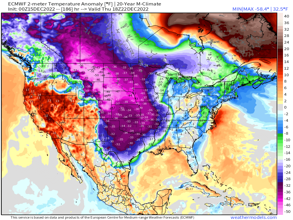
AccuWeather forecasted the cold air could "challenge records that have stood since the 1980s from the northern Rockies to the Southeast, as well as stress energy grids, in the run-up to the Christmas holiday."
Houston-based NatGas research firm Criterion Research has been telling clients all week about the potential for upcoming freeze-offs.
Criterion said, "Midland, Texas, will post average temperatures below freezing for multiple days, with nightly lows of 20 degrees and daily highs just above the freeze line." They said in similar instances, freeze-offs have occurred, curtailing production.
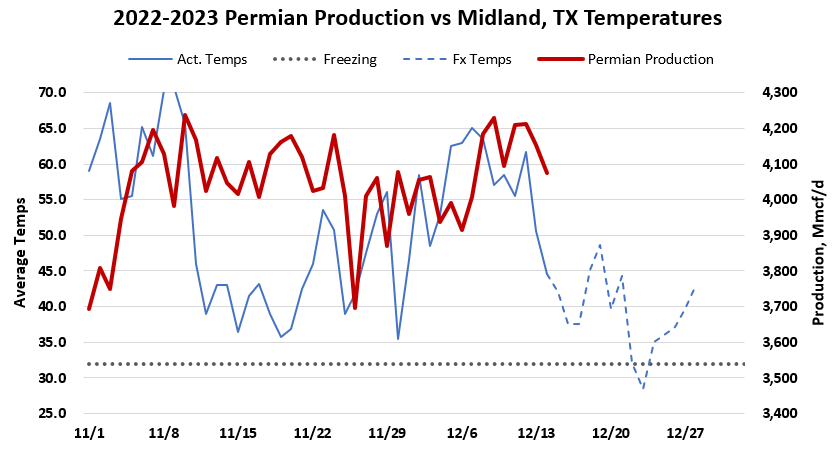
The research firm said ERCOT's guidance for next week "is shaping up to be a big showing, with the ISO showing total load rising to 53 GW on Thursday (12/22). However, the demand shot is not quite as high as peak days during last winter and well off of summer highs for the ISO."
They noted ERCOT's fossil fuel power generation sources would rise next week to 30 GW. Any production freeze-off could affect energy flows to power plants.
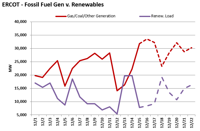
"One concern that could lead to tightness for natural gas supply & demand is the rising risk of freeze-offs in the Southern US," Criterion said.
Next week's forecast for Central US and Texas sent natural gas futures soaring more than 7.5% today.
And as a reminder, Texas largely relies on NatGas for power generation. What could possibly go wrong?
Zerohedge
ZeroHedge - On a long enough timeline, the survival rate for everyone drops to zero
 www.zerohedge.com