
You are using an out of date browser. It may not display this or other websites correctly.
You should upgrade or use an alternative browser.
You should upgrade or use an alternative browser.
WEATHER DERECHO - Significant Thunderstorm Wind Threat This Afternoon for Southern WI and Northern/Central Illinois
- Thread starter Red Baron
- Start date


WanderLore
Veteran Member
central michigan, almost to ohio line. watching this
Capt. Eddie
Veteran Member
This is what it looked like going through western Iowa this morning...

TxGal
Day by day
We were watching the Weather Channel about 20 mts ago. They were showing film of the city of Chicago, and all the boats out on the lake....I don't think they're going to be able to get to shore, even if they tried. If not, a lot of those boats (sailboats, etc.) may well capsize.
psychgirl
Has No Life - Lives on TB
Wow, that almost reminds me of hurricane videos!
The NWS Storm Prediction Center's severe weather forecast has significantly deteriorated since yesterday.
Now a widespread, long lasting severe wind event (Derecho) is forecast.
The SPC Day 1 forecast is being upgraded from an Enhanced to a Moderate Risk.
A rare PDS "Particularly Dangerous Situation" Thunderstorm Watch has been issued.
Stand by for more details.

Just drove through it coming home. Impressive storm. Glad I am home.

Michiana MaJo
Deceased
Winds from 70-80 expected in this area (SW lower Mich.) heading here very soon.....likely high wind damage predicted.
Should be out of here by 8 pm EDT.
Should be out of here by 8 pm EDT.


Michiana MaJo
Deceased
adgal, that sure WAS a terrible storm! I don't think I've ever seen photos of interior damage....I wonder what their roof looked like!
adgal
Veteran Member
There were no pictures of the roof - but I couldn't get over the 2x4s impaling the house. They said wind speeds reached 115 mph.adgal, that sure WAS a terrible storm! I don't think I've ever seen photos of interior damage....I wonder what their roof looked like!
mzkitty
I give up.


Martinhouse
Deceased
Just heard from my brother in Cedar Rapids. They had lots of damage but are both okay. He didn't have time for many details. Figures they will be out of power for several days.
Meadowlark
Has No Life - Lives on TB
and eventually into central and southern Indiana
Ractivist
Pride comes before the fall.....Pride month ended.
Was on the road head d home when it hit champaign Illinois. It picked up a whole lot of dust on the leading edge. Visibility at one point feet, thank God for headlights. I happened to be in a construction sight situation which really made it dusty. Debris on the roads from trees, not much else along my path. Fortunately it's been dry so the tree roots are firm....had it been soggy, be trees down everywhere. The storm front was the dangerous part, not much rain behind it.....but enough for the plants today.
mzkitty
I give up.


Meadowlark
Has No Life - Lives on TB
derecho sized shelf cloud.This is what it looked like going through western Iowa this morning...
View attachment 213757
Meadowlark
Has No Life - Lives on TB
derecho events can be long lasting and can maintain their own tenacity well into the early morning hours. They are already talking about extended more severe storm watches into the Ohio valley and into Kentucky. That means I will be under the gun by 11 PM. I hope I dont get a power outage. I am attending an online webinar tuesday and wednesday afternoon.

Milkweed Host
Veteran Member
I was in Iowa City when this storm came through. It was wild. I lost count to how many
tractor-trailers were blown over. Trees were down, power out and stop and go traffic on the interstate.
Tow trucks and squads all over the place. Sure looked busy and I'm glad that I'm retired....
Sorry, no photos. I have a cell phone that doesn't take photos.
tractor-trailers were blown over. Trees were down, power out and stop and go traffic on the interstate.
Tow trucks and squads all over the place. Sure looked busy and I'm glad that I'm retired....
Sorry, no photos. I have a cell phone that doesn't take photos.
Meemur
Voice on the Prairie / FJB!
Thanks for the prayers!
Just checking in. Post #43 by Capt. Eddie shows what it looked like in my neighborhood about 10:40 am this morning. I quickly moved my porch furniture inside and battened down the hatches and then took the cat to the basement. The wind was howling like a freight train, but I already knew from the weather alert that these were straight-line winds of 70+ mph. Although scary, the derecho is far less likely to implode a house!
When I emerged from the basement about 20 minutes later, the power was out and my neighborhood was full of downed trees, but everyone was fine. We worked on clean up the rest of the day. Power was restored about 3:55 pm (or so).
Pictures of Packy's area are heart-breaking: lots of century-old oak trees up ended and tons of damage. I hope she and OC are OK! They might be without power for awhile. The storm was widespread thoughout the state and crews are stretched thin.
Prep note: so glad I was ready for a power outage! That was one less think I had to think about this morning.
marymonde
Veteran Member
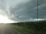
This was taken as the storm approached. Right after I took it the winds were literally blowing the corn sideways. It looks like we have two inches of rain so far, with the radar indicating we have a long way to go before it’s over. Last week we had 13 inches of rain over a three day period.
Attachments
marymonde
Veteran Member
Glad you are ok Meemur!!Thanks for the prayers!
Just checking in. Post #43 by Capt. Eddie shows what it looked like in my neighborhood about 10:40 am this morning. I quickly moved my porch furniture inside and battened down the hatches and then took the cat to the basement. The wind was howling like a freight train, but I already knew from the weather alert that these were straight-line winds of 70+ mph. Although scary, the derecho is far less likely to implode a house!
When I emerged from the basement about 20 minutes later, the power was out and my neighborhood was full of downed trees, but everyone was fine. We worked on clean up the rest of the day. Power was restored about 3:55 pm (or so).
Pictures of our Packy's area are heart-breaking: lots of century-old oak trees up ended and tons of damage. I hope she and OC are OK! They might be without power for awhile. The storm was widespread thoughout the state and crews are stretched thin.
Prep note: so glad I was ready for a power outage! That was one less think I had to think about this morning.
Severe weather threat continues,

Mesoscale Discussion 1461
NWS Storm Prediction Center Norman OK
0517 PM CDT Mon Aug 10 2020
Areas affected...southern lower Michigan...Indiana...southern
Illinois...east-central Missouri...northern Kentucky...and western
Ohio
Concerning...Severe Thunderstorm Watch 428...429...
Valid 102217Z - 110015Z
The severe weather threat for Severe Thunderstorm Watch 428, 429
continues.
SUMMARY...Widespread damaging wind gusts will continue across WW 428
and 429, and eventually will spread into adjacent/downstream areas.
One or more new WW issuances may be needed to cover the fast-moving
threat.
DISCUSSION...Latest radar loop shows a well-defined bowing MCS
moving quickly eastward/southeastward at 40 to 45 kt across the
Midwest, with the main convective line now east of Chicago, and
moving toward Grand Rapids/Indianapolis/St. Louis.
While moderate instability remains just downstream of the
convection, which will allow storms to remain intense over the next
hour, instability lessens with eastward and southeastward extent
east of the existing watches. Still, given the very well-organized
nature of this convective system, an organized/bowing band is likely
to continue east and southeast of the existing watches. While
severe risk should begin to diminish/become more isolated this
evening, a new WW issuance -- into eastern lower Michigan and
western Ohio, may be required. Some risk may also spread southeast
of the existing watches across the Ohio River into northern Kentucky
as well --- which could also require WW consideration.
..Goss.. 08/10/2020
Storm Prediction Center Mesoscale Discussion 1461
Severe weather, tornado, thunderstorm, fire weather, storm report, tornado watch, severe thunderstorm watch, mesoscale discussion, convective outlook products from the Storm Prediction Center.
www.spc.noaa.gov
SouthernBreeze
Has No Life - Lives on TB
Thanks for checking in, Meemur! I was really concerned for you, Packy, and others who were facing this storm. I also hope that Packy and OC are ok. We got word that a neighbor's tree had fallen on their garage, but don't know about their house.
Meemur
Voice on the Prairie / FJB!
Thanks for checking in, Meemur! I was really concerned for you, Packy, and others who were facing this storm. I also hope that Packy and OC are ok. We got word that a neighbor's tree had fallen on their garage, but don't know about their house.
Thanks for your concern! I'm no stranger to wind. (-:
Packy and OC are in a wooded neighborhood with lots of old-growth trees, so I'm not shocked if they are without power. Their house is fairly sturdy but they might be trapped on their street by downed power lines mixed up with fallen trees.
We were warned this morning about this potential on the AM news, and weather warnings went out about 40 minutes or so before the storm hit, not to mention the sky was telegraphing a warning, so it wasn't like this storm came out of nowhere. What surprised me was the high wind speeds. I'm sure there were some gusts 80+, judging by the damage.


Macgyver
Has No Life - Lives on TB
We picked up this storm while driving east at the neb/ia border on 80.
It was a bitch.
Passed over 20 tractor trailers over turned.
Few campers
I lost count at 50 of those digital message boards on wheels flipped as well.
We stoped it the big Iowa 80 truck stop for lunch around 2.
There was destruction all the way into Peoria il.
Big highway signs snapped off and laid over as well.
Just crossed into Indiana. Storm is still ahead of us it looks like.
I get a new wave of appreciation for our fire, EMS and LE in times like these. Plainfield has a working house fire (now under control) and there was an auto accident just north. Pittsboro Road is completely blocked by a large downed tree. There's a lot of lightening with this storm; I sure wouldn't want to be working outside in it.
Blacknarwhal
Let's Go Brandon!
Real attenuated by the time it got here, thank God. We live a good ways from the lake so that tends to help mitigate severe weather. Not even a flicker in the power!
adgal
Veteran Member
A friend of mine - a meteorologist - said the winds were clocked up to 115 mph today in Iowa.Thanks for your concern! I'm no stranger to wind. (-:
Packy and OC are in a wooded neighborhood with lots of old-growth trees, so I'm not shocked if they are without power. Their house is fairly sturdy but they might be trapped on their street by downed power lines mixed up with fallen trees.
We were warned this morning about this potential on the AM news, and weather warnings went out about 40 minutes or so before the storm hit, not to mention the sky was telegraphing a warning, so it wasn't like this storm came out of nowhere. What surprised me was the high wind speeds. I'm sure there were some gusts 80+, judging by the damage.
Meemur
Voice on the Prairie / FJB!
A friend of mine - a meteorologist - said the winds were clocked up to 115 mph today in Iowa.
That doesn't surprise me! So glad I was home.