DISASTER China's Three Gorge Dam in Danger

bw

Fringe Ranger
All I see is normal reservoir operations...Unless there is actual evidence of massive widespread upstream deluges in the last two weeks (which, as best as I can tell, is internet idiots confusing eastern-coast storms for far-west rainfall) there is really nothing to see here.

So perhaps bullet dodged, no collapse imminent. Perhaps. Next questions are what kind of damage has been done to the structure, what will it take to put right, and what risks are involved in normal operations.
 

Countrymouse

Country exile in the city
Recognizing the potential of PWI I deleted a very snarky response to this post, deciding it wasn't very gentlemanly. Instead I'll offer the following:

The best data we have of the reservoir stage-storage-discharge (in this case inflow-stage-discharge) condition is at Three Gorges Dam Monitoring . The latest info we have is represented graphically as:
View attachment 213952

The chart (dismissed previously as "damn statistics" but, in fact, is among the most important data for reservoir management) generally shows a significant reduction of inflow - aka rainfall runoff coming to the dam - since July 28 (green dots). As such, the dicharge (outflow, or red line) has been consciously reduced (fewer gates open) as the stage (water surface level, or blue line) has come down.

All I see is normal reservoir operations...Unless there is actual evidence of massive widespread upstream deluges in the last two weeks (which, as best as I can tell, is internet idiots confusing eastern-coast storms for far-west rainfall) there is really nothing to see here.

Let me know if I'm missing something...

Thank you.

If we can believe it (and it appears there is no reason to doubt it) the charts do seem to indicate less inflow.

Now comes the job of mopping up the mess in the flooded farmlands and cities....
 

DannyBoy

Veteran Member
Recognizing the potential of PWI I deleted a very snarky response to this post, deciding it wasn't very gentlemanly. Instead I'll offer the following:

The best data we have of the reservoir stage-storage-discharge (in this case inflow-stage-discharge) condition is at Three Gorges Dam Monitoring . The latest info we have is represented graphically as:
View attachment 213952

The chart (dismissed previously as "damn statistics" but, in fact, is among the most important data for reservoir management) generally shows a significant reduction of inflow - aka rainfall runoff coming to the dam - since July 28 (green dots). As such, the dicharge (outflow, or red line) has been consciously reduced (fewer gates open) as the stage (water surface level, or blue line) has come down.

All I see is normal reservoir operations...Unless there is actual evidence of massive widespread upstream deluges in the last two weeks (which, as best as I can tell, is internet idiots confusing eastern-coast storms for far-west rainfall) there is really nothing to see here.

Let me know if I'm missing something...
Interesting corroboration, is that the red line (outflow) matches with the level shown in the downstream camera... the level I have mentioned shown by the rocks being exposed. As the outflow drops, so does the downstream water level...
 

OldArcher

Has No Life - Lives on TB
As of 2326 CDT, 3GD000.com/video2, side angle, is frozen- stopped. What appears to be a man standing just before the downward left turn has not moved, nor has the spray or high volume discharge. Anybody have any ideas as to why image is frozen?

Bright Blessings,

OldArcher, Witch

PS Doesn't image, still active of spillway angle appear to have higher water level, yet lower arc of water/vapor?

Blessed Be,

oa, W
 

DannyBoy

Veteran Member
As of 2326 CDT, 3GD000.com/video2, side angle, is frozen- stopped. What appears to be a man standing just before the downward left turn has not moved, nor has the spray or high volume discharge. Anybody have any ideas as to why image is frozen?

Bright Blessings,

OldArcher, Witch

PS Doesn't image, still active of spillway angle appear to have higher water level, yet lower arc of water/vapor?

Blessed Be,

oa, W
Yeah, frozen for me also... on the spillway angle view, it is not frozen... the rock in the center foreground is looking like it might be going back under water, and there is at least one more gate maybe two, open since yesterday. That tracks with the red line on the chart above, Surface Tension posted...
 

OldArcher

Has No Life - Lives on TB
3GD000.com side view camera is still frozen, only sound is makig it through- if it is... Chicom's have shown their lack of technical prowess on this one... Spill way camera, unlike side view, shows near total darkness Wonder if all this means anything?

Bright Blessings,

OldArcher, Witch
 

DannyBoy

Veteran Member
from the spillway camera, several gates open (5:00 am over there). Water level downstream is up, most rocks are not showing. Side view camera is locked for me at this point...
 

LucyT

Senior Member
Paul Furber

@paul_furber

·
6h

Interesting. Xiluodu Dam just disappeared from Google Maps. It was there yesterday. It is a massive landmark - the third largest arch dam in the world - and it's been removed. Is it perhaps no longer there?

...

Xiluodu Dam, Jinsha River, China - Water Technology
The Xiluodu Dam is the second biggest dam in China. Image: courtesy of Vacon. Xiluodu Dam was constructed along the Jinsha River on the upper reaches of the Yangtze River. Image courtesy of Vacon. The fixed hoist headstock gears used for operating the gates of the dam are controlled by Vacon AC drives.


https://twitter.com/paul_furber/status/1294383043940175873
 

LucyT

Senior Member
8/14/20 22:00

272615204

On a local matter in China. The military has been rounding up a lot of folks lately and killing them because of their involvement in the Dam's construction. The method is quite interesting. They are dropping them in curing concrete on several construction projects around China. Quaint. Not sure what this is about. My Russian friend though it was quite funny. Guess they have their own barrels.


Countrymouse

Country exile in the city


it's a blamed BIG dam:

1l-image-19.jpg


Location
Lower Jinsha River


Anyone able to get a satellite of that area, so we can SEE what's happening? It CAN'T be cloudy in China ALL the time...
 

SurfaceTension

Veteran Member
Someone asked earlier if the reservoir engineers "make room" for flood waters. See the vertical orange line below reflecting conditions on 08/12/20. Note that although inflow (green dots) was decreasing and the water surface elevation (blue line) was dropping, they began increasing the discharge (red line). They were drawing down the surface elevation, to provide storage, in anticipation of upstream runoff/inflow that began hitting the reservoir on 08/13/20 and peaked on 08/15/20. If there are no other large rainfall events ongoing right now, the operators will likely begin stepping down the outfall (i.e. closing gates).
Lather, rinse, repeat

1597492968786.png
 

DannyBoy

Veteran Member
Someone asked earlier if the reservoir engineers "make room" for flood waters. See the vertical orange line below reflecting conditions on 08/12/20. Note that although inflow (green dots) was decreasing and the water surface elevation (blue line) was dropping, they began increasing the discharge (red line). They were drawing down the surface elevation, to provide storage, in anticipation of upstream runoff/inflow that began hitting the reservoir on 08/13/20 and peaked on 08/15/20. If there are no other large rainfall events ongoing right now, the operators will likely begin stepping down the outfall (i.e. closing gates).
Lather, rinse, repeat

View attachment 214448
Yeah, there is a bunch of inflow right now... the downstream camera is showing many gates open at this point... note the current level, blue line heading up despite the high flow.

Water levels are showing high per the camera (rocks, etc under water), so the flow on the chart is certainly legit.

Current view, with light show going on...
3gd21-51-8.15.JPG

What was showing last evening our time... lots of gate open
3gd9-14-8.14.JPG
 

SurfaceTension

Veteran Member
Is the flooding just about over and no more damage to the dam, now?
I looked at Accuweather and there is a wicked-nasty storm near the city of Chengdu that appears to be in the Yangtze River watershed. The radar loop looked like it was raining buckets and not moving out anytime soon. I generally don't follow China's weather but it doesn't look like they're out of the woods yet for flooding.

Of course one of the two primary purposes of the 3GD is to receive floodwater, store it, and release it at a slower rate to ameliorate flooding downstream of the dam. Flatten the curve, as it were, of the slugs of floodwaters from storms. It appears they have worked down the reservoir surface level quite low to provide additional storage.

As for the condition of the dam, I don't have a clue. China isn't forthcoming on anything; IIRC the only evidence of anything wrong is a vague quote from a dam worker, then countless videos and pontification from dubious bloggers and alleged time-travellers. As far as I'm concerned it's all speculation; others have more faith in these sources than I do.
 

Squid

Veteran Member
They will be shipping or mixing that stuff with quasi fresh and shipping that to the US if they gave that to locals CCP might give them 1 to the back of the head.

All processing in China should be blocked on shipping back to the US.
 

DannyBoy

Veteran Member
Any hint that the power generation system has been damaged?
the near side in the picture is certainly operating, you can see the turbulence, but no way to tell from the pic how many turbines are running, etc.

note that the angle view camera is operating again. Had been frozen for a couple days or more. Lots of gates open!!
3gd11-21-8.17.JPG
 

soccerdad3

Contributing Member
Seems like a weekly event.....


China's Yangtze River sees fifth flood of the year
Xinhua | Updated: 2020-08-17 20:09
more_art.gif


5f3a738ea3108348fce57700.jpeg
Photo taken on Aug 14, 2020 shows water gushing out from the Three Gorges Dam in Central China's Hubei province. [Photo/Xinhua]
BEIJING -- Yangtze River, China's longest, Monday recorded the fifth flood of the year in its upper reaches after a spell of heavy rainfall, the Ministry of Water Resources said.

The flood formed with a rapid increase of flow at Cuntan hydrologic station in Southwest China's Chongqing municipality. At 2 pm Monday, the station saw a water flow of 50,100 cubic meters per second.

The ministry has called on relevant authorities to strengthen monitoring and early-warning as well as flood prevention efforts in the Three Gorges reservoir and other main reservoirs.

The fourth flood was recorded on Aug 14.
 

soccerdad3

Contributing Member
It looks like flood #6 is next week....


China on alert for Yangtze River flooding as storms close in

Alice Yan
South China Morning Post17 August 2020


Heavy rain is expected across China’s southwest, northwest and northeast in the next three days, raising flood risks and pressure on dams, weather forecasters have warned.
The Ministry of Water Resources urged local authorities to be on alert, particularly along the upper reaches of the Yangtze River and the middle reaches of the Yellow, Hai, Songhua and Liao rivers.
The National Meteorological Centre said Sichuan province in the country’s southwest would be particularly hard hit, with up to 300mm (11.8 inches) of rain forecast for Monday.
Get the latest insights and analysis from our Global Impact newsletter on the big stories originating in China.
Between 30-50mm of rain is expected to fall per hour in the provinces of Yunnan, Gansu, Shaanxi, Hebei, Inner Mongolia and Heilongjiang, rising to over 70mm an hour in some scattered areas.

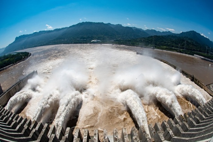
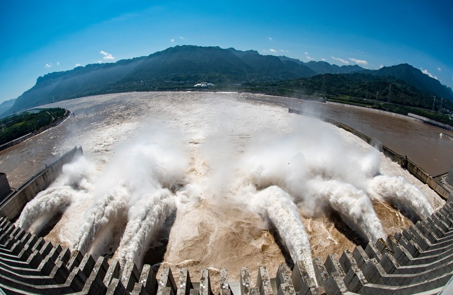
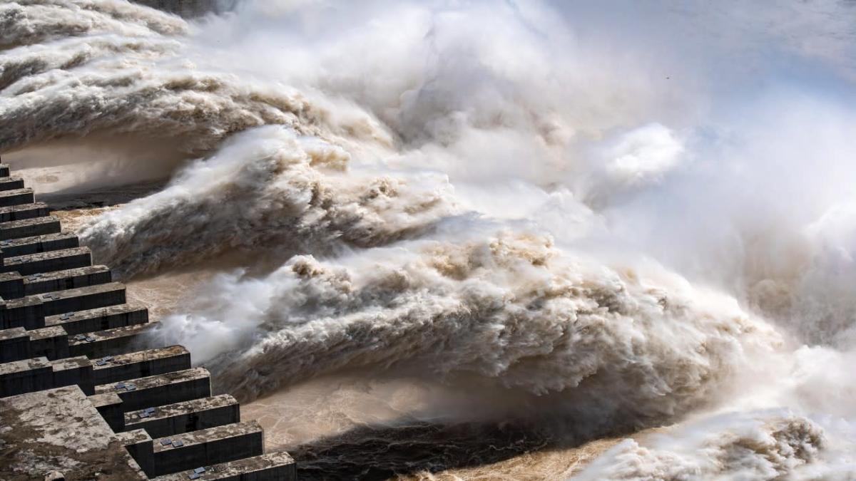
Water Resources Minister E Jingping said the Three Gorges Dam and others in the upper reaches of the Yangtze should release water “precisely” to prevent floods, state news agency Xinhua reported.
Upstream dams should take on as much water as possible to ease pressure on the Three Gorges, he said.
The lower reaches of the Yangtze are still recovering from heavy flooding last month that affected a large part of southeastern China.
In all, 219 people have died or are missing in this year’s floods, and more than 63 million residents have been affected.
The minister said authorities should also pay attention to the possible floods along the Hai, Liao, Songhua, Wei and Yellow rivers, and step up safety checks to ensure new flood defences built on the Wei River in Shanxi province would hold.

The country’s southwest has been ordered to be alert for landslides and mudslides.
In Chongqing, the water level at one monitoring station along the river is expected to exceed the safe level by about one metre on Tuesday night, Xinhua reported.
According to national regulations, floods are designated at critical levels once the water exceeds the safety level.
Conditions are expected to be worse along the Jialing River, a tributary that joins the Yangtze in Chongqing, with water at one monitoring station forecast to rise to 2.5-3.5 metres higher than the safety level on Tuesday morning.
In the northwest, Lueyang county in Shaanxi province ordered residents living in ground-floor housing to move to upper floors to avoid fast-moving floods. The government has allocated primary and middle schools as emergency shelters and set up tents there, Shanghai-based news site Thepaper.cn reported.


Warm Wisconsin

Easy as 3.141592653589..
Anyone keep up with the resent events I'm reading they now have all the flood gates wide open.

Not wide open. They are at 70k cubic Meter per second. On paper the 3GD can do 180k Cubic meters per second, but ideal is to remain below 100k cubic meters per second. That includes the electric generation numbers.

The dam still has 20 meters of reserve height before entering “alert” level.

At the current fill rate of 9-16 cm a day. Well...they have some time for the incoming flood waters to slow
 
Top