WEATHER CentralTexas Coast going to get wet this weekend - Hurricane Harvey Thread

thompson

Certa Bonum Certamen
https://twitter.com/breakingweather/status/900796423620448257

AccuWeather‏Verified account @breakingweather

Mandatory evacuations have been issued for parts of southern Texas, including for the city of Portland: http://ow.ly/X23w30eELFi #Harvey

DIBFkn-XoAAQJVH.jpg
 

shane

Has No Life - Lives on TB
A cat 4 that goes through quick is not as bad as a cat 2 or 3 that parks on top of you for 2 or 3 days.

That's what could make this a monumental mess, if it stalls and hangs around, dumping feet of rain,
and especially on coast to the east of it, where storm surge gets to pile in atop each high tide cycle.

- Shane

PS - Victoria, TX, hour south of us, just issued mandatory evacuation, that's a city of 70,000 that'll
now be headed our way. Our population here in Gonzales is only a tenth of that stampede coming.
Not to mention all the other counties and communities within 100 miles of coast also heading north.
Soon, we'll be sold out of everything, won't be able to get in & around town for all the stalled traffic.
 
Last edited:

peacewithin

Leave a ❤️print wherever u go
http://www.theadvocate.com/new_orleans/news/article_04664174-88d7-11e7-96b4-bb1962e0fe05.html

Landrieu updates New Orleans pumps, says 'more clarity' to come ahead of Hurricane Harvey


Officials still do not have a clear idea of the city's drainage capacity as Hurricane Harvey barrels toward the Texas coast, likely sending heavy bands of rain over New Orleans this weekend.

More information about exactly how much water the S&WB's pumps can remove from the city, and how fast, is expected tomorrow morning, the day Harvey will make landfall, Mayor Mitch Landrieu said during a morning press conference.

Landrieu remained vague about what circumstances could trigger an evacuation.

Though far from New Orleans itself, Harvey is expected to drop between 5 inches and 10 inches of rain on the city, and possibly twice that in some areas, Landrieu said.

That could cause flooding even in the best of circumstances, Landrieu said. But with more than a dozen S&WB drainage pumps offline and only two of the five turbines that power them running, the impacts of heavy rains could be devastating.

Landrieu said officials still do not know what the city's current pumping capacity is with 15 of its 120 pumps offline but said engineers are expected to provide an estimate on Friday.

The city's normal plans call for an evacuation if a Category 3 hurricane is set to strike.

During planning sessions with FEMA and state officials, the Landrieu administration has been considering scenarios that could trigger an evacuation solely for rain because of the diminished capacity of the drainage system.

But asked whether an evacuation could be called for Harvey, Landrieu said, "The answer is 'not yet.' "

Latest forecasts indicated the storm would make landfall along the Texas coast at some point on Friday, likely bringing significant rainfall to much of Louisiana.

"All of us need to lean forward, to be alert, to clean catch basins and be prepared," Landrieu said.

The city has been working with federal officials to establish an evacuation plan for areas is significant rain strikes while the drainage system remains at a diminished capacity. He addressed recent reports that the Lakeview area would be the first to be evacuated in that instance, but did not confirm report.

"[That's] one of many scenarios" being considered, he said.

Check back for more.
 

Red Baron

Paleo-Conservative
_______________
---------
BULLETIN
Hurricane Harvey Intermediate Advisory Number 18A
NWS National Hurricane Center Miami FL AL092017
700 PM CDT Thu Aug 24 2017

...HARVEY MOVING NORTHWESTWARD TOWARD THE TEXAS COAST...
...LIFE-THREATENING AND DEVASTATING FLOODING EXPECTED NEAR THE
COAST DUE TO HEAVY RAINFALL AND STORM SURGE...


SUMMARY OF 700 PM CDT...0000 UTC...INFORMATION
----------------------------------------------
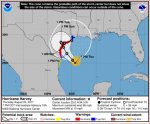
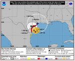
LOCATION...25.0N 94.3W
ABOUT 275 MI...445 KM SE OF CORPUS CHRISTI TEXAS
ABOUT 270 MI...435 KM SSE OF PORT OCONNOR TEXAS
MAXIMUM SUSTAINED WINDS...85 MPH...140 KM/H
PRESENT MOVEMENT...NW OR 325 DEGREES AT 10 MPH...17 KM/H
MINIMUM CENTRAL PRESSURE...974 MB...28.76 INCHES


WATCHES AND WARNINGS
--------------------
CHANGES WITH THIS ADVISORY:

None.

SUMMARY OF WATCHES AND WARNINGS IN EFFECT:

A Storm Surge Warning is in effect for...
* Port Mansfield to High Island Texas

A Storm Surge Watch is in effect for...
* South of Port Mansfield Texas to the Mouth of the Rio Grande

A Hurricane Warning is in effect for...
* Port Mansfield to Sargent Texas

A Tropical Storm Warning is in effect for...
* North of Sargent to High Island Texas
* South of Port Mansfield Texas to the Mouth of the Rio Grande

A Hurricane Watch is in effect for...
* South of Port Mansfield Texas to the Mouth of the Rio Grande

A Tropical Storm Watch is in effect for...
* South of the Mouth of the Rio Grande to Boca de Catan Mexico

A Storm Surge Warning means there is a danger of life-threatening
inundation, from rising water moving inland from the coastline,
during the next 36 hours in the indicated locations. For a depiction
of areas at risk, please see the National Weather Service Storm
Surge Watch/Warning Graphic, available at hurricanes.gov. This is a
life-threatening situation. Persons located within these areas
should take all necessary actions to protect life and property from
rising water and the potential for other dangerous conditions.
Promptly follow evacuation and other instructions from local
officials.

A Hurricane Warning means that hurricane conditions are expected
somewhere within the warning area. A warning is typically issued
36 hours before the anticipated first occurrence of tropical-storm-
force winds, conditions that make outside preparations difficult or
dangerous. Preparations to protect life and property should be
rushed to completion.

A Storm Surge Watch means there is a possibility of life-
threatening inundation, from rising water moving inland from the
coastline, in the indicated locations during the next 48 hours.

A Hurricane Watch means that hurricane conditions are possible
within the watch area.

In addition, interests in southwestern Louisiana should continue to
monitor the progress of this system.

For storm information specific to your area in the United
States, including possible inland watches and warnings, please
monitor products issued by your local National Weather Service
forecast office. For storm information specific to your area outside
the United States, please monitor products issued by your national
meteorological service.


DISCUSSION AND 48-HOUR OUTLOOK
------------------------------
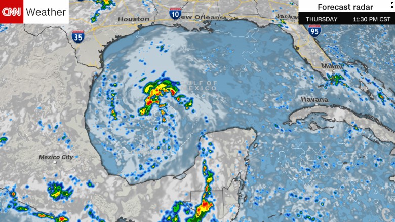
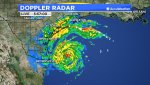
At 700 PM CDT (0000 UTC), the eye of Hurricane Harvey was located
near latitude 25.0 North, longitude 94.3 West. Harvey is moving
toward the northwest near 10 mph (17 km/h). This general motion is
expected to continue with a decrease in forward speed during the
next couple of days.
On the forecast track, Harvey will approach
the middle Texas coast on Friday and make landfall Friday night or
early Saturday. Harvey is then likely to stall near or just inland
of the middle Texas coast through the weekend.

Reports from an Air Force Reserve Hurricane Hunter aircraft
indicate that maximum sustained winds remain near 85 mph (140 km/h)
with higher gusts. While Harvey has changed little in strength
over the past few hours, strengthening is expected to resume during
the next few hours, and Harvey is expected to become a major
hurricane by Friday before it reaches the middle Texas coast.


Hurricane-force winds extend outward up to 25 miles (35 km) from
the center, and tropical-storm-force winds extend outward up to 90
miles (150 km).

The minimum central pressure just reported by the Hurricane Hunter
Aircraft is 974 mb (28.76 inches).

HAZARDS AFFECTING LAND
----------------------
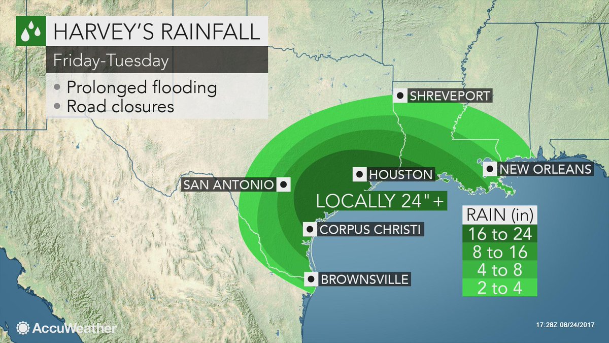
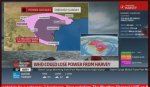
RAINFALL: Harvey is expected to produce total rain accumulations
of 15 to 25 inches and isolated maximum amounts of 35 inches over
the middle and upper Texas coast through next Wednesday
. During the same time period Harvey is expected to produce total rain
accumulations of 7 to 15 inches in far south Texas and the Texas
Hill Country over through central and southwest Louisiana, with
accumulations of up to 7 inches extending into other parts of Texas
and the lower Mississippi Valley. Rainfall from Harvey will cause
devastating and life-threatening flooding.

STORM SURGE: The combination of a dangerous storm surge and the
tide will cause normally dry areas near the coast to be flooded by
rising waters moving inland from the shoreline. The water is
expected to reach the following heights above ground if the peak
surge occurs at the time of high tide...

N Entrance Padre Island Natl Seashore to Sargent...6 to 12 ft
Sargent to Jamaica Beach...5 to 8 ft
Port Mansfield to N Entrance Padre Island Natl Seashore...5 to 7 ft
Jamaica Beach to High Island...2 to 4 ft
Mouth of the Rio Grande to Port Mansfield...2 to 4 ft
High Island to Morgan City...1 to 3 ft

The deepest water will occur along the immediate coast near and to
the northeast of the landfall location, where the surge will be
accompanied by large and destructive waves. Surge-related flooding
depends on the relative timing of the surge and the tidal cycle, and
can vary greatly over short distances. For information specific to
your area, please see products issued by your local National Weather
Service forecast office.

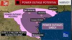
WIND: Hurricane conditions are likely within the hurricane warning
area late Friday or Friday night, with tropical storm conditions
expected to first reach the coast in the hurricane warning area
Friday.

SURF: Swells generated by Harvey are likely to affect the Texas,
Louisiana, and northeast Mexico coasts by Friday. These swells are
likely to cause life-threatening surf and rip current conditions.
Please consult products from your local weather office.

TORNADOES: Isolated tornadoes are possible across portions of the
middle and upper Texas coast on Friday.

NEXT ADVISORY
-------------
Next complete advisory at 1000 PM CDT.

http://www.nhc.noaa.gov/text/refresh/MIATCPAT4+shtml/242359.shtml
 

Red Baron

Paleo-Conservative
_______________
Weather Channel forecasting an almost fantastic strengthening over the next 24 hours. 85 mph (Cat-1) to 125 mph (CAT-3) with landfall of the eye late Friday or early Saturday. Then there will be relatively little movement for a few days resulting in a very significant rain event.

There is going to be a lot happening in a day or so. I hope people on the coast finish preparations and get out of there on Friday.

http://www.nhc.noaa.gov/refresh/graphics_at4+shtml/212153.shtml?cone#contents
 

Attachments

  • Harvey.jpg
    Harvey.jpg
    86.6 KB · Views: 266

Warm Wisconsin

Easy as 3.141592653589..
A cat 4 that goes through quick is not as bad as a cat 2 or 3 that parks on top of you for 2 or 3 days.

That's what could make this a monumental mess, if it stalls and hangs around, dumping feet of rain,
and especially on coast to the east of it, where storm surge gets to pile in atop each high tide cycle.

- Shane

PS - Victoria, TX, hour south of us, just issued mandatory evacuation, that's a city of 70,000 that'll
now be headed our way. Our population here in Gonzales is only a tenth of that stampede coming.
Not to mention all the other counties and communities within 100 miles of coast also heading north.
Soon, we'll be sold out of everything, won't be able to get in & around town for all the stalled traffic.

The current run of the GFS model makes me sick. I don't think there is anyway a storm can stall as longS the model is showing, but it's not looking good.

https://www.tropicaltidbits.com/ana...apcpn&runtime=2017082418&fh=0&xpos=0&ypos=475

In the model (linked above) shows a large area getting 24+ inches of rain. When you go to the link--make sure you select total precipitation and push play.
 
Last edited:

xbeeman412

Contributing Member
We are in Santa Fe Tx just north of Galveston Island and have had rain on and off today. We are raised up 2 feet on 2 acres so will be high and dry on our island if the 30 inches of rain get here.

As an off note We went through 36 inch rain in 79 and survived.
 

Dennis Olson

Chief Curmudgeon
_______________
I just got back from the store. Needed milk, TP and various other things. Also filled up the gas can for the genset should that need arise. All that leaves is covering the car (which I'll do in about an hour), and then button-up for the weekend. The gallons of bottled water leaving the store was incredible. Morons.
 

kenny1659

Veteran Member
We have a few little things to do tomorrow morning Then it is in God's hands. Food, water, fuel for generator, and loose objects secured. I pray we don't get really high winds. We live on a hill so flooding is not a worry.
 

thompson

Certa Bonum Certamen

Buick Electra

TB2K Girls with Guns
Mary-Anne Reed · @LoveWatercolor
Hurricane Harvey · 22 minutes
#HurricaneHarvey is expected to strike as a Category 3 hurricane — meaning with winds greater than 111 miles per hour
 

shane

Has No Life - Lives on TB
This is important, so I'm going to repeat myself, as few know and most miss it, projected storm surges don't fully take into account
what happens when hurricane stalls, it does not just make for a longer sustained surge being higher and going further in country.

It also compounds, because it stalls, with ever more higher tides, twice a day, for as long as it stays there, that never fully recede in
between them
. They add up, every one, w/ resultant surge height & invasion in-land then being well beyond anybodies initial projections.

Can trap a lot of people who thought themselves safe, relying on historical data from hurricanes (some even bugger) but had moved faster.
About 50% of all hurricane deaths are from the surge, that people had underestimated how high and, especially, how far in-land it can go.

- Shane
 
Last edited:

Stormy

Veteran Member
Just spoke with my elderly aunt in Conroe. She is staying put in a flood-prone area; I can't count the times that home has flooded. She just had new flooring put in this spring due to the last bout of flooding.

She said "Oh, I'll be fine, the lake is way down and we need rain." Um, do you need 3 to 4 FEET of rain? I can't tell this lady anything, she is as stubborn as they come. Her son and his family live in a very nice home on a golf course in Montgomery, so they can come and get her unless the creek floods and traps her.

I remember one instance about 25 years ago that she and my uncle fled the house because of rapidly rising water. Can't recall if it was due to a hurricane/tropical storm or not. Anyway, when they finally were able to get back to their home, the only dry thing in the place was a suitcase full of clothes that was left on a bed - the mattress floated up to the ceiling and kept the suitcase dry. And the house was full of snakes.

She is 88 years old and will most likely wake up in her recliner with water all around her. Prayers for her and all good people and animals in the path of this storm.
 

Millwright

Knuckle Dragger
_______________
I just got back from the store. Needed milk, TP and various other things. Also filled up the gas can for the genset should that need arise. All that leaves is covering the car (which I'll do in about an hour), and then button-up for the weekend. The gallons of bottled water leaving the store was incredible. Morons.

Have you started said genset and perhaps run under a little bit of load in the last year or two? :D
 

somdwatcher

Veteran Member
http://weather.cod.edu/satrad/exper/?parms=meso1-13-200-1

Very long satellite loop (IR) for Harvey. Harvey has an inner core with intense convection completely surrounding the eye for the first time this evening, this satellite loop is very long and if you need to save bandwidth set the number of images to a lower number IE 12, 24, 48, 96. Pressure falls have started once again and recon reports have pressures in the 960's. We shall see if the Vortex message from the NHC confirms this latest situation. Prayers for all of you in Texas. This is going to be a real nightmare scenario just from rainfall, let alone any of the damages from a significant hurricane landfall.
 

Firedave

Senior Member
Been though this before in Conroe area. Good way to meet your neighbors and find out you wish you hadn't. Ya have to let them know your out of everything too. Ya just can't change stupid. But a good way to stay on top of your preps. And know who you can trust. [ Know your hood ]
 

Green Co.

Administrator
_______________
We're all ready here, though I think Austin may get as much or more rain than we do here, according to the weather man. Monkey County isn't even in the flash flood watch. **Yet**

Got my old Yamaha genset serviced today, new oil & air filter, ran for about 1/2 hour with a 1500 watt space heater hooked up, fueled up & ready. Already had plenty of groceries, fueled the trucks & cans for the genset. About as ready as we can get.

Now if these forecasters can get together in their predictions. Locals show it coming in between Corpus & Victoria, then eastward along the coast. TWC weather had it coming in closer to Corpus, then veering west towards San Antone & Austin. But both say the heaviest rain will be south of I-10... ok with me.
 

shane

Has No Life - Lives on TB
Glad I don't still have my sailboat in Pt Lavaca anymore. They are gonna get clobbered, it'll be a mish mash of wrecked boats, some
maybe up on main street, it's happened before. Had mine for a decade there, up until two years ago when my son took it to Mexico.

For Hurricane Rita, when mandatory evacuation declared there, I'd sailed off to Pt O'Connor and there confirmed it was still aiming at
straight into Matagorda Bay then, knowing they usually hooked, if not staying straight, more eastward than westward, so from there
I stuck to my original plan to quickly go southwest towards Mexico to put lots more distance between me and it, hopefully.

Trick with these strategies is timing, you have to wait long enough to see (guess) where it'll go before you know (guess) where safer
might be to get headed towards instead as quick as you can. That can be a very thin iffy window to decide and then commit to scoot.

That's how it worked out then, by the time I got to Corpus Christi I had my confirmation Rita had indeed hooked east towards Houston,
missing Pt Lavaca and Pt O'Connor altogether, but today, for this hurricane, I would not have attempted it, too broad to try and out run.

I'd probably of tried storm anchoring it in a small bay along the intercoastal and ride it out on board after stripping off & stowing sails.

Probably very good thing I don't still have that boat...

- Shane
 
Last edited:

mzkitty

I give up.
bradygibson‏ @bradygibson 7m7 minutes ago

#BREAKING National Hurricane Center upgrades Hurricane Harvey to Category 2, calling it a "life-threatening storm" @WISH_TV #Daybreak8
 

compchyk

The Computer Chyck
For those of you in the storm path make sure you have your homeowners and flood ins policies nearby with phone numbers for both. Also if you get flooded out take the number for Servpro. The last 2hurricanes here they saturated the area with people. They do an incredible job helping you dry out and when I needed to file the ins claim I had no problem getting reimbursed.
 

thompson

Certa Bonum Certamen
VIDEO at the source

http://www.cnn.com/2017/08/24/us/tropical-storm-harvey/index.html

'Life-threatening' rainfall expected in Texas, hurricane center says

By Nicole Chavez, Eliott C. McLaughlin and Steve Almasy, CNN
Updated 4:25 AM ET, Fri August 25, 2017

(CNN)Highways in Texas filled with cars Thursday into the night as coastal residents made their way north and out of the path of a hurricane that forecasters say will bring "life-threatening" amounts of rain.

Some areas could get as many as 35 inches of rain from Hurricane Harvey and many will get more than a foot, forecasters from the National Hurricane Center said. Harvey has strengthened to a Category 2 storm, with maximum sustained winds of 100 mph, according to the National Weather Service.

As Harvey gained strength Thursday, residents along the Texas coast made the choice to evacuate or stay. Those staying in place aren't taking any chances; they're filling sandbags, stocking up on water and boarding up windows.

Harvey is rapidly becoming more powerful and is forecast to become a Category 3 hurricane with winds of at least 111 mph by the time it hits the middle Texas coast late Friday or early Saturday, the hurricane center said Thursday. After hitting Corpus Christi, the storm is expected to stall over the state, forecasters say.

In Corpus Christi, where Harvey could make landfall and Mayor Joe McComb has issued a voluntary evacuation order, Walmart shelves were clearing quickly, as the city canceled Friday's dockets in city court and provided self-serve sandbags to residents.

Hurricane-force winds are a concern as the storm builds strength in the Gulf of Mexico, and a potential deluge and subsequent flooding may be a big danger as well, according to meteorologists.

Track Harvey

Timelapse of WP-3D Orion #NOAA42 flying a pass through the eye of #HurricaneHarvey from west to east. Advisories at https://t.co/3phpgKMZaS pic.twitter.com/b5lyqqkW9x
— NOAAHurricaneHunters (@NOAA_HurrHunter) August 24, 2017​


"Harvey is likely to bring multiple hazards, including heavy rainfall, storm surge and possible hurricane conditions to portions of the Texas coast beginning Friday," the National Weather Service said.

"Those conditions can happen far away from the landfall," hurricane specialist John Cangialosi said Thursday afternoon.

People shouldn't focus on where the eye will come ashore but should listen to local authorities and be prepared for rain through the weekend and possibly into next week, he added.

"This is really going to stretch the emergency services in the state of Texas in the days ahead," CNN meteorologist Tom Sater said.

Making preparations

Northbound Interstate 37 out of Corpus Christi was filled as people evacuated. The highway, which goes to San Antonio, was backed up for miles while the southbound lanes were mostly empty, a photo from Mari C. Rivera shows.

Rose Yepez told CNN it took her twice as long as normal to drive from Corpus Christi to San Antonio. Yepez, who was continuing her travels to the Texas Hill Country, said traffic was constantly slowing down and coming to a stop during the 140-mile drive.

170824203838-corpus-christi-traffic-exlarge-169.jpg


Northbound traffic was using the shoulder and three regular lanes to get out of Corpus Christi.

Not everyone is leaving. Rebecca Esparza of Corpus Christi said her family is prepared to stay in their now-boarded up house.

"I want to leave, but I refuse to leave my mom behind," she said, noting that her mom rode out Hurricane Celia in 1970.

"We have lots of bottled water, satellite radio, lanterns, bagged ice," she said.
Amanda Weldy is staying put, too.

170824204135-corpus-christi-stocking-up-exlarge-169.jpg


Amanda Weldy plans to ride out the storm with her family.

She said the family is freezing lots of bottled water to keep perishable food cold. She also plans to have everyone shower Friday morning then fill up the tub in case the water lines get contaminated.

"Mostly we are just making sure our 2- and 1-year-old have everything they need," she said.

Other people around Corpus Christi started stocking up Wednesday on food, bottled water and other essentials.

"We know that if anything as far as flooding happens, that's the one thing everyone runs to, we have to have water," Mariah Barter told CNN affiliate KZTV. "It's a big deal. It scares the hell out of people. It's better to be prepared."

Many residents of South Texas readied sandbags, fueled up power generators and bought plywood to board up their windows, CNN affiliate KRIS reported.

Slow storm means more rain

At 11 p.m. ET, Harvey was a Category 1 hurricane with 85 mph winds. It was about 250 miles southeast of Corpus Christi, and was moving northwest at 10 mph.

It's expected to bring 15 to 25 inches of rain to the Texas coast, with isolated instances where rainfall totals could reach 35 inches, the hurricane center said.

"Rainfall from Harvey will cause devastating and life-threatening flooding," the center warned.

170822140508-weather-possible-hurricane-exlarge-169.jpg


Rainfall amounts increase exponentially when a storm moves at a slower speed, as Harvey has been doing.

The National Hurricane Center has warned Harvey will slow down when it reaches the coast and there will be days of heavy rain and flooding across portions of Texas. Louisiana and Mexico will also be affected by the storm.

Compounding potential problems is the tidal cycle. If peak storm surge arrives during high tide, parts of the coast could see 1 to 8 feet of flooding, with the potential of 6 to 12 feet between Padre Island National Seashore and Sargent, Texas.

"Historically, water from tropical cyclones is more deadly" than from damage done by the powerful winds of the storm, Cangialosi said.

While it has been nine years since Texas last saw a hurricane, the state is no stranger to devastating flooding from tropical systems. In 2001, Tropical Storm Allison was a multibillion-dollar disaster for the state, specifically Houston. Allison became nearly stationary for days, dropping more than 30 inches of rain across portions of the city.

Facing pump problems, New Orleans braces for Harvey

A hurricane warning is in effect from Port Mansfield near Mexico to Sargent, with a storm surge warning stretching from Port Mansfield to High Island in Galveston County.

Harvey could be the first hurricane to hit Texas since 2008 when Hurricane Ike smashed the coast near Galveston. The storm killed 21 people in Texas, Louisiana and Arkansas, and caused widespread destruction.

'It scares the hell out of people'

As Harvey churned toward Texas, Gov. Greg Abbott declared a state of disaster Wednesday in 30 counties along the Gulf of Mexico. The governor's action allows agencies to "quickly deploy resources for the emergency response."

"Texans believe in taking action and always being prepared in the event of an emergency," Abbott said. "That is why I am taking every precaution prior to ... Harvey making landfall."

On Thursday the governor activated 700 members of the Texas Army Guard, Texas Air National Guard and the Texas State Guard.

Energy companies are evacuating personnel from off-shore production platforms, the US Bureau of Safety and Environmental Enforcement announced.

In San Antonio, Mayor Ron Nirenberg issued a local disaster declaration warned residents about going out in the rain.

There are evacuation orders in many counties and cities, including Victoria, near where the eye of the storm may hover for days.

At a Thursday afternoon White House briefing, Press Secretary Sarah Huckabee Sanders said President Donald Trump has been briefed on Harvey. She downplayed concerns about preparedness, given that there is no permanent Homeland Security secretary, and said the White House is in "great shape," given that chief of staff John Kelly was previously in charge of the office.
 

somdwatcher

Veteran Member
Still intensifying.

http://www.nhc.noaa.gov/text/MIAREPNT2.shtml

000
URNT12 KNHC 251017
VORTEX DATA MESSAGE AL092017
A. 25/09:56:10Z
B. 26 deg 06 min N
095 deg 35 min W
C. 700 mb 2693 m
D. 86 kt
E. 135 deg 7 nm
F. 232 deg 92 kt
G. 140 deg 10 nm
[I]H. 953 mb
[/I]I. 13 C / 3061 m
J. 17 C / 3046 m
K. 10 C / NA
L. CLOSED
M. C11
N. 1234 / 7
O. 0.02 / 0.75 nm
P. AF305 1709A HARVEY OB 12
MAX FL WIND 96 KT 116 / 17 NM 08:46:30Z
CNTR DROPSONDE SFC WIND 155 / 16 KT
MAX FL TEMP 17 C 360 / 2 NM FROM FL CNTR
;
 

mzkitty

I give up.
Travis Herzog‏ @TravisABC13 33s33 seconds ago

#BREAKING: #Harvey intensification underway. @NHC_Atlantic has upped winds to 110 mph, just 1 mph shy of cat 3.
 

Attachments

  • harvey 1.jpg
    harvey 1.jpg
    114.7 KB · Views: 202

Warm Wisconsin

Easy as 3.141592653589..
Well there is a well defined eye this morning, and no eye wall replacement cycle happening.

The pressure has dropped 20+mb overnight.

The winds always lag the pressure drop. If this storm gets to be a Cat 3 and the outflows grow the storm surge will be the story. If the surge sustains at all it will slow down the surface rains from flowing out to the gulf.

I think taking Shane's advise above is very wise.
 

Warm Wisconsin

Easy as 3.141592653589..
The outflows are increasing and hurricane force winds now 35 miles from the eye. The shear actually seems to be feeding the outflows. This isn't unheard of but is very rare. If we get to the magic 45 miles hurricane force winds from the eye it will be bad news. I still don't see this storm going above 120 mph winds at the surface level, but could see those 125+ winds at 1200-1500 ft. This will increase the chances of tornadoes.
 

Red Baron

Paleo-Conservative
_______________
Coastal Watches/Warnings and Forecast Cone for Storm Center
 

Attachments

  • Harvey.jpg
    Harvey.jpg
    84.4 KB · Views: 167
Top