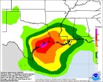
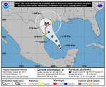
WEATHER CentralTexas Coast going to get wet this weekend - Hurricane Harvey Thread

The Traveler

Veteran Member
I am afraid this is going to suck for a lot of people. Harvey came back from the dead...

http://www.nhc.noaa.gov/

000
WTNT34 KNHC 231448
TCPAT4

BULLETIN
Tropical Depression Harvey Advisory Number 12
NWS National Hurricane Center Miami FL AL092017
1000 AM CDT Wed Aug 23 2017

...HARVEY REGENERATES INTO A TROPICAL DEPRESSION...
...HURRICANE AND STORM SURGE WATCHES ISSUED FOR PORTIONS OF THE
TEXAS COAST...


SUMMARY OF 1000 AM CDT...1500 UTC...INFORMATION
-----------------------------------------------
LOCATION...21.5N 92.5W
ABOUT 535 MI...860 KM SSE OF PORT OCONNOR TEXAS
ABOUT 470 MI...755 KM SE OF PORT MANSFIELD TEXAS
MAXIMUM SUSTAINED WINDS...35 MPH...55 KM/H
PRESENT MOVEMENT...NW OR 310 DEGREES AT 9 MPH...15 KM/H
MINIMUM CENTRAL PRESSURE...1006 MB...29.71 INCHES


WATCHES AND WARNINGS
--------------------
CHANGES WITH THIS ADVISORY:

A Storm Surge Watch has been issued for the coast of Texas from
Port Mansfield to High Island.

A Hurricane Watch has been issued for the coast of Texas from north
of Port Mansfield to San Luis Pass.

A Tropical Storm Watch has been issued for the coast of Texas from
the Mouth of the Rio Grande to Port Mansfield and from north of
San Luis Pass to High Island.

The government of Mexico has issued a Tropical Storm Watch for the
coast of Mexico from Boca De Catan to the Mouth of the Rio Grande.

SUMMARY OF WATCHES AND WARNINGS IN EFFECT:

A Storm Surge Watch is in effect for...
* Port Mansfield to High Island

A Hurricane Watch is in effect for...
* North of Port Mansfield to San Luis Pass

A Tropical Storm Watch is in effect for...
* Boca De Catan Mexico to Port Mansfield Texas
* North of San Luis Pass to High Island

A Storm Surge Watch means there is a possibility of life-
threatening inundation, from rising water moving inland from the
coastline, in the indicated locations during the next 48 hours.
For a depiction of areas at risk, please see the National Weather
Service Storm Surge Watch/Warning Graphic, available at
hurricanes.gov.

A Hurricane Watch means that hurricane conditions are possible
within the watch area. A watch is typically issued 48 hours
before the anticipated first occurrence of tropical-storm-force
winds, conditions that make outside preparations difficult or
dangerous.

A Tropical Storm Watch means that tropical storm conditions are
possible within the watch area, generally within 48 hours.

Interests in southwestern Louisiana should monitor the progress of
this system for possible watches this afternoon.

For storm information specific to your area in the United States,
including possible inland watches and warnings, please monitor
products issued by your local National Weather Service forecast
office. For storm information specific to your area outside the
United States, please monitor products issued by your national
meteorological service.


DISCUSSION AND 48-HOUR OUTLOOK
------------------------------
At 1000 AM CDT (1500 UTC), the center of Tropical Depression Harvey
was located near latitude 21.5 North, longitude 92.5 West. The
depression is moving toward the northwest near 9 mph (15 km/h) and
a track toward the northwest or north-northwest is expected for the
next 48 hours. On the forecast track, Harvey should be approaching
the Texas coast late Friday.

Maximum sustained winds are near 35 mph (55 km/h) with higher gusts.
Some strengthening is forecast during the next 48 hours, and Harvey
could become a hurricane on Friday.

An Air Force Reserve Hurricane Hunter aircraft recently reported a
minimum central pressure of 1006 mb (29.71 inches).


HAZARDS AFFECTING LAND
----------------------
RAINFALL: Harvey is expected to produce total rain accumulations of
10 to 15 inches with isolated maximum amounts of 20 inches over the
middle and upper Texas coast and southwest Louisiana through next
Tuesday, with heavy rainfall beginning as early as Friday morning.
Harvey is also expected to produce total rain accumulations of 3 to
9 inches in portions of south, central, and northeast Texas and the
rest of the lower Mississippi Valley. Rainfall from Harvey could
cause life-threatening flooding.

STORM SURGE: The combination of a dangerous storm surge and the tide
will cause normally dry areas near the coast to be flooded by rising
waters moving inland from the shoreline. The water is expected to
reach the following heights above ground if the peak surge occurs at
the time of high tide...

Port Mansfield to High Island...4 to 6 ft

The deepest water will occur along the immediate coast near and to
the northeast of the landfall location, where the surge will be
accompanied by large and destructive waves. Surge-related
flooding depends on the relative timing of the surge and the tidal
cycle, and can vary greatly over short distances. For information
specific to your area, please see products issued by your local
National Weather Service forecast office.

WIND: Hurricane conditions are possible within the hurricane watch
area by late Friday, with tropical storm conditions possible by
early Friday.

SURF: Swells generated by Harvey are likely to affect the Texas,
Louisiana, and northeast Mexico coasts by Friday. These swells are
likely to cause life-threatening surf and rip current conditions.
Please consult products from your local weather office.


NEXT ADVISORY
-------------
Next intermediate advisory at 100 PM CDT.
Next complete advisory at 400 PM CDT.

$$
Forecaster Blake
 

Publius

TB Fanatic
Buy milk, bread and toilet paper. :hof: But seriously its that time of year again for these storms so best check your supplies.
 

Terrwyn

Veteran Member
Pray for Old as Dirt. She is expecting 14 inches of rain at her place. House sits on high ground but she will be cut off from the world by a flooded creek.
 

Stormy

Veteran Member
Pray for Old as Dirt. She is expecting 14 inches of rain at her place. House sits on high ground but she will be cut off from the world by a flooded creek.

Wow, I sure will! Hope there is someone to help her get supplies in and get ready. Glad her home is on high ground.

Talked to my friend in Aransas Pass this morning. She said they would be ready by this evening. Their home and barn are on high ground and built like a fortress with very sturdy hurricane shutters, so I am not too worried about them and their horses and other animals. They have been through many storms and hurricanes.

Sounds like Houston will have bad flooding:shk:
 
Last edited:

thompson

Certa Bonum Certamen
Was raining cats and dogs here in Brazos county the past 30-45 minutes. Still raining, but down to kittens and puppies. ;)
 

Wise Owl

Deceased
Might as well throw up a radar loop for the US. It will update every 15 mins or so. Just hit refresh.
You can watch it landfall........

usa_None_anim.gif
 

Dennis Olson

Chief Curmudgeon
_______________
Pups are exercised, picked up their meds, and the car is under its cover. I'm as ready as I'm going to get. Forecast says rain in the next 45 minutes or so.
 

TxGal

Day by day
Was raining cats and dogs here in Brazos county the past 30-45 minutes. Still raining, but down to kittens and puppies. ;)

We're just a bit north of you, that was one heck of a rainfall! About 1.5 hrs of very heavy rainfall with no let up until just a few minutes ago...lightning now north of us.
 

shane

Has No Life - Lives on TB
I'm not even close to any bodies of water.

Not yet maybe...

Of course, we're smack in the middle of the 'Cone of Destruction' here, too. An hour south of you, as you know.

It's lightning & thundering here, now, though unrelated to this coming weekend's festivities.

This week, so far, fired up and fueled up 5-ton, tested two generators and trash water pump, filled up an extra
fresh water 55 gal barrel, recharging & topping off all back-up batteries for lights, comms, etc.

Got to get my back-up pick-up truck out of shop this week and its fuel topped off, too.

We're not in low lying flood area and will be fine as long as we keep the roof on and tie things down so we don't
have too much flying loose around the yard here.

Just sold and shipped out my last four mini shelters today...

IMG_1236 (1).JPG

... still have one buried in back of building for tornadoes.

Never boring...

- Shane
 
Last edited:

kenny1659

Veteran Member
Latest news report is calling for landfall near Corpus Christi late Friday or early Saturday morning as a cat 1 hurricane. Forward speed has slowed to 2 mph. This gives it longer over the warm gulf waters. Prayers for everyone in the path of this storm.

PS: Just got back from a topping off run to WM in Beeville, TX. Store was crowded for a Wednesday evening. Canned meats, bottled water, and bread were wiped out.
 

somdwatcher

Veteran Member
It's officially Tropical Storm Harvey now.(special update, flight level winds stronger in NE quadrant)

http://www.nhc.noaa.gov/text/refresh/MIATCUAT4+shtml/240403.shtml

Tropical Storm Harvey Tropical Cyclone Update
NWS National Hurricane Center Miami FL AL092017
1100 PM CDT Wed Aug 23 2017

...AIR FORCE PLANE FINDS TROPICAL STORM FORCE WINDS...

An Air Force Reserve hurricane hunter aircraft just measured
tropical storm force winds in Harvey. The maximum winds are
estimated to be 40 mph (65 km/h) with higher gusts.

SUMMARY OF 1100 PM CDT...0400 UTC...INFORMATION
----------------------------------------------
LOCATION...22.0N 92.6W
ABOUT 500 MI...810 KM SSE OF PORT OCONNOR TEXAS
ABOUT 440 MI...705 KM SE OF PORT MANSFIELD TEXAS
MAXIMUM SUSTAINED WINDS...40 MPH...65 KM/H
PRESENT MOVEMENT...NW OR 325 DEGREES AT 2 MPH...4 KM/H
MINIMUM CENTRAL PRESSURE...1002 MB...29.59 INCHES

$$
Forecaster Avila/Zelinsky
 

somdwatcher

Veteran Member
Prayers for all of you down in Texas, this storm is going to be quite a bad deal. Even if it is "just" a rain maker. Very severe flooding seems to be the big talk on weather forums and weather models. Do not become fixed on maximum wind speed or a precise landfall for this storm. The impacts will very likely be widespread across central/eastern/southern Texas.
 

somdwatcher

Veteran Member
Anthony Sagliani

@anthonywx
Large amount of lightning in evolving TS Harvey. Specifically, there is a rather unusually high amount of positive C-G (yellow +) strikes.
12:36 AM - Aug 24, 2017
 

somdwatcher

Veteran Member
http://www.nhc.noaa.gov/text/refresh/MIATCPAT4+shtml/240541.shtml?

BULLETIN
Tropical Storm Harvey Intermediate Advisory Number 14A
NWS National Hurricane Center Miami FL AL092017
100 AM CDT Thu Aug 24 2017

...AIR FORCE AND NOAA PLANES FIND HARVEY A LITTLE STRONGER...


SUMMARY OF 100 AM CDT...0600 UTC...INFORMATION
----------------------------------------------
LOCATION...22.6N 92.6W
ABOUT 465 MI...740 KM SSE OF PORT OCONNOR TEXAS
ABOUT 410 MI...660 KM SE OF PORT MANSFIELD TEXAS
MAXIMUM SUSTAINED WINDS...45 MPH...70 KM/H
PRESENT MOVEMENT...NW OR 325 DEGREES AT 7 MPH...11 KM/H
MINIMUM CENTRAL PRESSURE...1001 MB...29.56 INCHES
 

ejagno

Veteran Member
Further reconnaissance is verifying that Harvey has consolidated more north than previously found. Expect this to alter the track a bit north of it's previous track. It has also found it to continue strengthening at this time. I don't think any of the models expected this so quickly. The longer it sits out there meandering around the worse this will get. Models seem to be having a difficult time with this storm.
 

shane

Has No Life - Lives on TB
Hmmm, this could become bigger than anyone first imagined.

There's small military airport on Rt 90A just east of Seguin (Randolph AFB Auxiliary Field) used for
training instructors that FEMA has used the gated grounds there before for hurricanes as a primary
pre-staging area of food/water/cots/medical/coms 18-wheelers. Will check later today and see if
they've been moving in again there and try and get some photos if they have.

- Shane
 

Wise Owl

Deceased
Yeah Thompson, that's nasty! You folks stay safe and dry down there......

Wonder where it will head after Texas? These things have a habit of turning northeast and ending up in Maine as gully washers....sigh. Just had a bad storm up here night before last. Lost power over large parts of western and central Maine...

Good thing we are all preppers, huh.....
 

somdwatcher

Veteran Member
Pressure down to 986mb and this will likely be a cane before noon. Scary situation developing in Texas.

http://www.nhc.noaa.gov/text/refresh/MIATCPAT4+shtml/241146.shtml

BULLETIN
Tropical Storm Harvey Intermediate Advisory Number 15A
NWS National Hurricane Center Miami FL AL092017
700 AM CDT Thu Aug 24 2017

...AIR FORCE HURRICANE HUNTER PLANE FINDS HARVEY STRENGTHENING...


SUMMARY OF 700 AM CDT...1200 UTC...INFORMATION
----------------------------------------------
LOCATION...23.8N 93.0W
ABOUT 380 MI...615 KM SE OF PORT OCONNOR TEXAS
ABOUT 335 MI...540 KM SE OF PORT MANSFIELD TEXAS
MAXIMUM SUSTAINED WINDS...60 MPH...95 KM/H
PRESENT MOVEMENT...NNW OR 345 DEGREES AT 10 MPH...17 KM/H
MINIMUM CENTRAL PRESSURE...986 MB...29.12 INCHES


WATCHES AND WARNINGS
--------------------
CHANGES WITH THIS ADVISORY:

None.

SUMMARY OF WATCHES AND WARNINGS IN EFFECT:

A Storm Surge Warning is in effect for...
* Port Mansfield to San Luis Pass Texas

A Storm Surge Watch is in effect for...
* South of Port Mansfield Texas to the Mouth of the Rio Grande
* North of San Luis Pass to High Island Texas

A Hurricane Warning is in effect for...
* Port Mansfield to Matagorda Texas

A Tropical Storm Warning is in effect for...
* North of Matagorda to High Island Texas
* South of Port Mansfield Texas to the Mouth of the Rio Grande

A Hurricane Watch is in effect for...
* South of Port Mansfield Texas to the Mouth of the Rio Grande

A Tropical Storm Watch is effect for...
* South of the Mouth of the Rio Grande to Boca de Catan Mexico

A Storm Surge Warning means there is a danger of life-threatening
inundation, from rising water moving inland from the coastline,
during the next 36 hours in the indicated locations. For a
depiction of areas at risk, please see the National Weather
Service Storm Surge Watch/Warning Graphic, available at
hurricanes.gov. This is a life-threatening situation. Persons
located within these areas should take all necessary actions to
protect life and property from rising water and the potential for
other dangerous conditions. Promptly follow evacuation and other
instructions from local officials.

A Hurricane Warning means that hurricane conditions are expected
somewhere within the warning area. A warning is typically issued
36 hours before the anticipated first occurrence of tropical-storm-
force winds, conditions that make outside preparations difficult or
dangerous. Preparations to protect life and property should be
rushed to completion.

A Tropical Storm Warning means that tropical storm conditions are
expected somewhere within the warning area within 36 hours.

A Storm Surge Watch means there is a possibility of life-
threatening inundation, from rising water moving inland from the
coastline, in the indicated locations during the next 48 hours.

A Hurricane Watch means that hurricane conditions are possible
within the watch area.

A Tropical Storm Watch means that tropical storm conditions are
possible within the watch area.

In addition, interests in southwestern Louisiana should continue to
monitor the progress of this system.

For storm information specific to your area in the United
States, including possible inland watches and warnings, please
monitor products issued by your local National Weather Service
forecast office. For storm information specific to your area outside
the United States, please monitor products issued by your national
meteorological service.


DISCUSSION AND 48-HOUR OUTLOOK
------------------------------
At 700 AM CDT (1200 UTC), the center of Tropical Storm Harvey was
located by a reconnaissance plane near latitude 23.8 North,
longitude 93.0 West. Harvey is moving toward the north-northwest
near 10 mph (17 km/h). A track toward the northwest or
north-northwest at a faster forward speed is expected for the next
48 hours. On the forecast track, Harvey will approach the southern
Texas coast on Friday.

An Air Force Reserve aircraft reports that the maximum sustained
winds have increased to near 60 mph (95 km/h) with higher gusts.
Additional strengthening is forecast during the next 48 hours, and
Harvey is expected to become a hurricane by Friday.

Tropical-storm-force winds extend outward up to 115 miles (185 km)
from the center.

The minimum central pressure based on data from the Air Force
Hurricane Hunter aircraft is 986 mb (29.12 inches).


HAZARDS AFFECTING LAND
----------------------
RAINFALL: Harvey is expected to produce total rain accumulations of
10 to 15 inches with isolated maximum amounts of 25 inches over the
Texas coast through next Wednesday. During the same time period
Harvey is expected to produce total rain accumulations of 3 to 9
inches along its outer radius including parts of south, central, and
eastern Texas and the lower Mississippi Valley. Rainfall from Harvey
may cause life-threatening flooding.

STORM SURGE: The combination of a dangerous storm surge and the
tide will cause normally dry areas near the coast to be flooded by
rising waters moving inland from the shoreline. The water is
expected to reach the following heights above ground if the peak
surge occurs at the time of high tide...

Port Mansfield to San Luis Pass...5 to 7 ft
San Luis Pass to High Island...2 to 4 ft
Mouth of the Rio Grande to Port Mansfield...2 to 4 ft
 

somdwatcher

Veteran Member
Michael Ventrice

@MJVentrice
#GOES16 data showing an eye wrapping up in the center of #Harvey this morning as the storm undergoes rapid intensification.
7:49 AM - Aug 24, 2017

Eyewall is open to the NW quadrant as per recent recon report.
 

SusieSunshine

Veteran Member
Yep, we are going to get wet. Our weather alert:

From Friday afternoon through Sunday morning * Copious amounts of rain are expected beginning Friday Afternoon and lasting through at least Sunday morning as Tropical Storm Harvey moves onshore. This watch may need to be expanded in time and area over the next several days as Harvey lingers around the area through the weekend. Rainfall totals in the watch area through early next week will average 8 to 15 inches with isolated amounts up to 20 inches.
 

The Traveler

Veteran Member
This goes from bad to worse. Also, Txkstew, can you modify the heading of this thread to reflect the status change of this storm for others to see the changes. Thanks.

http://www.nhc.noaa.gov/text/refresh/MIATCPAT4+shtml/241454.shtml

00
WTNT34 KNHC 241454
TCPAT4

BULLETIN
Tropical Storm Harvey Advisory Number 16
NWS National Hurricane Center Miami FL AL092017
1000 AM CDT Thu Aug 24 2017

...HARVEY QUICKLY STRENGTHENING AND FORECAST TO BE A MAJOR
HURRICANE WHEN IT APPROACHES THE MIDDLE TEXAS COAST...
...LIFE-THREATENING STORM SURGE AND FRESHWATER FLOODING EXPECTED...


SUMMARY OF 1000 AM CDT...1500 UTC...INFORMATION
-----------------------------------------------
LOCATION...24.0N 93.3W
ABOUT 365 MI...590 KM SE OF CORPUS CHRISTI TEXAS
ABOUT 360 MI...580 KM SSE OF PORT OCONNOR TEXAS
MAXIMUM SUSTAINED WINDS...65 MPH...100 KM/H
PRESENT MOVEMENT...NNW OR 340 DEGREES AT 10 MPH...17 KM/H
MINIMUM CENTRAL PRESSURE...982 MB...29.00 INCHES


WATCHES AND WARNINGS
--------------------
CHANGES WITH THIS ADVISORY:

None.

SUMMARY OF WATCHES AND WARNINGS IN EFFECT:

A Storm Surge Warning is in effect for...
* Port Mansfield to San Luis Pass Texas

A Storm Surge Watch is in effect for...
* South of Port Mansfield Texas to the Mouth of the Rio Grande
* North of San Luis Pass to High Island Texas

A Hurricane Warning is in effect for...
* Port Mansfield to Matagorda Texas

A Tropical Storm Warning is in effect for...
* North of Matagorda to High Island Texas
* South of Port Mansfield Texas to the Mouth of the Rio Grande

A Hurricane Watch is in effect for...
* South of Port Mansfield Texas to the Mouth of the Rio Grande

A Tropical Storm Watch is in effect for...
* South of the Mouth of the Rio Grande to Boca de Catan Mexico

A Storm Surge Warning means there is a danger of life-threatening
inundation, from rising water moving inland from the coastline,
during the next 36 hours in the indicated locations. For a
depiction of areas at risk, please see the National Weather
Service Storm Surge Watch/Warning Graphic, available at
hurricanes.gov. This is a life-threatening situation. Persons
located within these areas should take all necessary actions to
protect life and property from rising water and the potential for
other dangerous conditions. Promptly follow evacuation and other
instructions from local officials.

A Hurricane Warning means that hurricane conditions are expected
somewhere within the warning area. A warning is typically issued
36 hours before the anticipated first occurrence of tropical-storm-
force winds, conditions that make outside preparations difficult or
dangerous. Preparations to protect life and property should be
rushed to completion.

A Tropical Storm Warning means that tropical storm conditions are
expected somewhere within the warning area within 36 hours.

A Storm Surge Watch means there is a possibility of life-
threatening inundation, from rising water moving inland from the
coastline, in the indicated locations during the next 48 hours.

A Hurricane Watch means that hurricane conditions are possible
within the watch area.

A Tropical Storm Watch means that tropical storm conditions are
possible within the watch area.

In addition, interests in southwestern Louisiana should continue to
monitor the progress of this system.

For storm information specific to your area in the United
States, including possible inland watches and warnings, please
monitor products issued by your local National Weather Service
forecast office. For storm information specific to your area outside
the United States, please monitor products issued by your national
meteorological service.


DISCUSSION AND 48-HOUR OUTLOOK
------------------------------
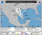
At 1000 AM CDT (1500 UTC), the center of Tropical Storm Harvey was
located by an Air Force Reserve Hurricane Hunter aircraft near
latitude 24.0 North, longitude 93.3 West. Harvey is moving toward
the north-northwest near 10 mph (17 km/h). A turn toward the
northwest is expected later today, and Harvey's forward speed is
forecast to slow down during the next couple of days. On the
forecast track, Harvey will approach the middle Texas coast on
Friday and make landfall Friday night or early Saturday, and then
stall near the middle Texas coast through the weekend.

Data from the Hurricane Hunter plane indicate that maximum sustained
winds have increased to near 65 mph (100 km/h) with higher gusts.
Rapid strengthening is forecast, and Harvey is expected to become a
major hurricane before it reaches the middle Texas coast.

Tropical-storm-force winds extend outward up to 90 miles (150 km)
from the center.

The minimum central pressure based on reconnaissance data is 982 mb
(29.00 inches).


HAZARDS AFFECTING LAND
----------------------
RAINFALL: Harvey is expected to produce total rain accumulations of
12 to 20 inches and isolated maximum amounts of 30 inches over the
middle and upper Texas coast through next Wednesday. During the same
time period Harvey is expected to produce total rain accumulations
of 5 to 12 inches in far south Texas and the Texas Hill Country to
central Louisiana, with accumulations of less than 5 inches
extending into other parts of Texas and the lower Mississippi
Valley. Rainfall from Harvey may cause life-threatening flooding.

STORM SURGE: The combination of a dangerous storm surge and the
tide will cause normally dry areas near the coast to be flooded by
rising waters moving inland from the shoreline. The water is
expected to reach the following heights above ground if the peak
surge occurs at the time of high tide...

N Entrance Padre Island Natl Seashore to Sargent...6 to 10 ft
Sargent to San Luis Pass...5 to 7 ft
Port Mansfield to N Entrance Padre Island Natl Seashore...5 to 7 ft
San Luis Pass to High Island...2 to 4 ft
Mouth of the Rio Grande to Port Mansfield...2 to 4 ft
High Island to Morgan City...1 to 3 ft

The deepest water will occur along the immediate coast near and to
the northeast of the landfall location, where the surge will be
accompanied by large and destructive waves. Surge-related flooding
depends on the relative timing of the surge and the tidal cycle, and
can vary greatly over short distances. For information specific to
your area, please see products issued by your local National Weather
Service forecast office.

WIND: Hurricane conditions are likely within the hurricane warning
area late Friday or Friday night, with tropical storm conditions
expected to first reach the coast in the hurricane warning area
Friday.

SURF: Swells generated by Harvey are likely to affect the Texas,
Louisiana, and northeast Mexico coasts by Friday. These swells are
likely to cause life-threatening surf and rip current conditions.
Please consult products from your local weather office.


NEXT ADVISORY
-------------
Next intermediate advisory at 100 PM CDT.
Next complete advisory at 400 PM CDT.

$$
Forecaster Berg
 

Old as dirt

Old as dirt
According to my weatherman here,[ Boswick} Says just maybe this baby will be a cat three hurricane when it hits land. And then the darn thing will sit off coast or meander around to cause extreme damage. Could make a turn to East and flood Houston. And then hit me. I cannot get to any small towns because of a creek that rises and shuts down the road. Flows extremely fast. So I am stuck here. I am going to wall mart today, Got cat food and dog food at tractor supply yesterday, Not to crowded yet, but did see a guy buy fifteen packages of bottled water.
Also got to gas up the car. I hate being alone in these storms.
I am happy for the fact that maybe not a lot of wind when it meanders my way, I have huge tree's all around the house, Trying to figure out where to park the car. Take care everyone
 

TxGal

Day by day
Confirming what OAD just said....they are forecasting Harvey will be a Cat 3 at landfall, and stay put for a while. Landfall still appears to be near Corpus. Very, very dangerous storm.

Editing to add it will drift eastward eventually, all of South Texas is likely to get heavy rain, Houston included (we're a few hrs north). New Orleans may also feel it....
 

Green Co.

Administrator
_______________
Yup, on the Cat 3

Tropical Storm Harvey projected to make landfall as Category 3 hurricane

Tropical Storm Harvey is strengthening as it heads toward the Texas Gulf Coast, and now is expected to make landfall Friday as a Category 3 hurricane, the National Hurricane Center said Thursday morning.

The last hurricane to strike Texas was Ike in 2008.

Category 3 hurricane winds reach 111 to 129 mph, said Paul Lewis, meteorologist with the National Weather Service. As of 10 a.m. Thursday, Tropical Storm Harvey winds were at 65 mph with even faster gusts - the higher end of a tropical storm.

Tropical Storm Harvey Update
Not specified
Media: Brandpoint
Th tropical storm is expected to become a hurricane later Thursday night or Friday morning.

Harvey was upgraded late Wednesday to a tropical storm, prompting the National Weather Service to issue a slew of hurricane and tropical storm warnings up and down the Texas coast.

A tropical storm warning was in effect through Saturday for Brazoria, Chambers, Fort Bend, Galveston, Harris, Liberty and Wharton counties.

Brazoria County was also under a storm surge warning. Chambers, Galveston and Harris are under storm surge watches.

A hurricane warning was in effect for Jackson and Matagorda counties.

Tropical Storm Harvey - which was upgraded about 11 p.m. Wednesday from a tropical depression - was over the south central Gulf of Mexico on Thursday morning, according to the NWS.

It is becoming faster and better organized as it moves northwest toward the Texas coast.

Thursday morning, the storm was moving toward the Gulf Coast at 10 mph. It is expected to hit the Gulf Coast on Friday, between Corpus Christi and Matagorda Bay, said NWS meteorologist Brian Kyle.

Tropical storm-force winds could pound Brazoria County's coastline as early as Friday afternoon, and continue through Saturday.

Houstonians are more likely to heavy rainfall and flooding, as the storm moves through southeast Texas.

The storm's sluggish pace increases the odds that Harris County - and areas across southeast Texas - could see levels of rainfall comparable to Tropical Storm Allison or the Tax Day Floods, but even more widespread, said Jeff Lindner, meteorologist with the Harris County Flood Control District.

"The potential here is for big rain amounts over a very large area," Lindner said. "That's something that's somewhat unprecedented across the Texas coast."

Residents who live south of Interstate 10 could see upwards of 20 inches of rain between Thursday and early next week, Kyle said.

"It's not all going to fall in a single day," Kyle said. "Totals are going to gradually add up."

Rainfall totals will be between 10 and 20 inches for the rest of Harris County. Officials are cautioning residents to stock up on food and water, prepare for power outages and stay off the roads.

"We're looking at a huge swath of territory on the southeast coasts that are getting a large amount of rain," said Francisco Sanchez, spokesman for the Harris County Office of Emergency Management. "If you have flooded in the past, you know to be watchful. If you are in an area that's gotten lucky over the past two years, please don't rely on that luck anymore."

There is a low-to-moderate chance of scattered showers and thunderstorms hitting Houston early Friday, as the outer bands of the storm come through the coast, according to the NWS.

Gusty winds - mostly below tropical storm speeds - will hit the Houston area Saturday morning and continue through the afternoon.

Isolated tornadoes may form within Tropical Storm Harvey's outer rain and storm bands. According to the NWS, the odds tornadoes will form will increase through Saturday afternoon.

The Harris County Emergency Operations Center is now staffed 24 hours a day. State officials arrived Thursday morning at the center, Sanchez said.

The county has also activated its Regional Joint Information Center - the mechanism it uses to keep people informed.

Once the storm nears the coast, Sanchez said the county will have a better understanding of just how bad flooding may be and whether residents in coastal communities will need to be evacuated.

Public school districts - a handful of which are scheduled to start school next week - said they're keeping an eye on the weather, but may not know whether classes will be cancelled until early Monday.

Fort Bend County Judge Robert Hebert on Thursday declared a local state of disaster, which sparks implementation of the county's emergency plan, according to a county news release.

Galveston County officials are encouraging residents to prep for supplies for up to three days, should they be unable to leave their houses, said Brittany Viegas, spokeswoman for the county.

"People need to be prepared to be stuck in homes with flooding and being stuck in homes without power," Viegas said.

Viegas added the county judge may call Thursday for a voluntary evacuation of the Bolivar Peninsula, as Highway 87 often becomes impassable after storms.

Brazoria County officials are also encouraging residents to prepare for power outages and flooding, especially in coastal communities that are expected to be especially hard hit.

"We're asking our residents to be vigilant and careful," said Brazoria County spokeswoman Sharon Trower. "And to be prepared for all of this heavy rain we're going to be getting."

As part of its preparations for the impending storm, the Red Cross put out a call Thursday for volunteers for warehousing, shelter management, supply distribution and administrative support.

"This is the type of situation we prepare for year-round," said David Brady, regional chief executive officer of the American Red Cross of the Texas Gulf Coast.

"We want to be sure we have enough people to help us help others," Brady added.

Volunteers can register at redcross.org/volunteer.

The Red Cross is also prepping shelter trailers, emergency response vehicles and kitchen support that can be sent out as needed.

http://www.chron.com/news/houston-w...ts-Texas-Latest-tropical-weather-11953474.php
 

Warm Wisconsin

Easy as 3.141592653589..
I study hurricanes as hobby. I am not an expert, but sometimes my forecast on hurricanes has been more accurate then the pros. This is mostly because the pros have to side on the of a larger hurricane, since under forecasting is more dangerous than over forecasting.

I took a look myself at the models and data, and I cant see this hurricane becoming a Cat 3 at this point. (even with the data that just came in moments ago) This could change as new data comes in this afternoon fly overs. However, I would say a strong Cat 1 and maybe a weak Cat 2 right now. The only way this storm could become a Cat 3 is if there is no eyewall replacements before landfall. It would be rare for the eyewall not be replaced sometime overnight or tomorrow morning.

I do expect heavy rains with this storm, and the storm could linger for 2-2.5 days. I think the forecast of the storm coming back and striking the coast twice is way premature of a forecast.

Just my take - Like I said I only do this as a hobby. (Yes, i find it fun)
 
Top