
You are using an out of date browser. It may not display this or other websites correctly.
You should upgrade or use an alternative browser.
You should upgrade or use an alternative browser.
WEATHER CentralTexas Coast going to get wet this weekend - Hurricane Harvey Thread

.jpg")
Txkstew
Veteran Member
This goes from bad to worse. Also, Txkstew, can you modify the heading of this thread to reflect the status change of this storm for others to see the changes. Thanks.
I tried to edit the Thread Heading when I first started it. It wouldn't let me. I've never tried to edit a Heading before. Maybe a Mod will fix it to fit the new developments. Thanks, all. I went to town earlier to get food stuff we were out of. Plenty of stock on the shelves now. Then I back tracked to the liquor store. Now I think I need to go get a jug or two of gasoline.
Shit, this is starting to look like the lead up to Hurricane Rita that hit here in 2005. First they said it was going to Corpus, then it was Angelton, then Galveston, then Bolivar. The next morning, I got up to hear the local weatherman say, that we need to get out now.
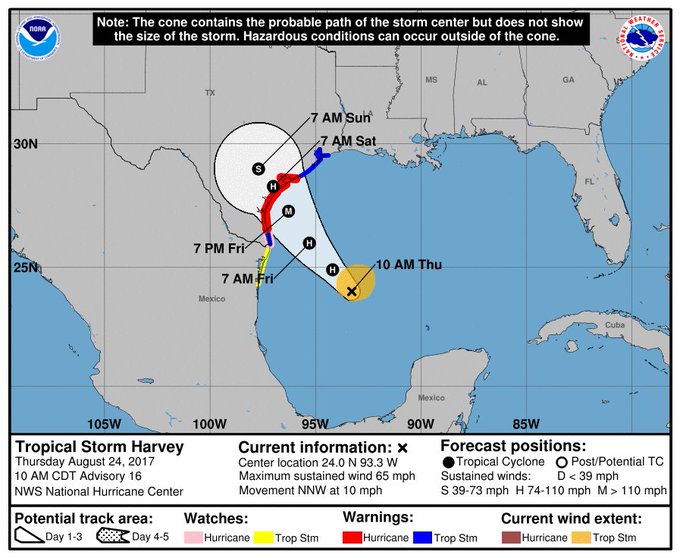
Possible Impact
TB Fanatic
 Natl Hurricane Ctr
 http://www.nhc.noaa.gov/
Last update Thu, 24 Aug 2017 17:08:01 UTC
Hurricane Harvey
...HARVEY STRENGTHENS TO A HURRICANE WITH 80-MPH WINDS...
12:00 PM CDT Thu Aug 24
Location: 24.3°N 93.5°W
Moving: NNW at 10 mph
Min pressure: 981 mb
Max sustained: 80 mph
____________________
NHC Atlantic Ops Verified account @NHC_Atlantic 2h
NEW: Harvey is quickly intensifying
& is now forecast to be a category 3 hurricane at landfall in Texas.
http://hurricanes.gov
 NHC Atlantic Ops Verified account @NHC_Atlantic 18m
 Harvey is now a hurricane w/80-mph winds.
A special advisory is coming by 1p CDT
to update the intensity forecast
http://hurricanes.gov
The evacuees from coast going through towns while heading north can be monster mess well before any storm arrives.
For Hurricane Rita, they'd cleaned out all our grocery stores, gas stations and clogged streets to where no movement.
We'll be popcorn watching those festivities from afar here.
- Shane
For Hurricane Rita, they'd cleaned out all our grocery stores, gas stations and clogged streets to where no movement.
We'll be popcorn watching those festivities from afar here.
- Shane
Sleeping Cobra
TB Fanatic
The Weather Channel said it may be a Cat 3+. Stay alert.
straightstreet
Life is better in flip flops
Storm2k thinks this will come ashore as a Cat4-perhaps 5. But that may be the amateurs talking.
Do you have a link? Thank you!
TxGal
Day by day
The evacuees from coast going through towns while heading north can be monster mess well before any storm arrives.
For Hurricane Rita, they'd cleaned out all our grocery stores, gas stations and clogged streets to where no movement.
We'll be popcorn watching those festivities from afar here.
- Shane
We remember that well, too. They came through like locusts, I kind of understand that but the sheer volume of people and their frame of mind was memorable. Many weren't just shopping for their evacuation time, but also for when they returned home. Some said their own stores had been cleaned out beforehand, so they doubted any stores would be restocked when they returned. Good thinking, actually, but they did a good job of cleaning out the groceries in a lot of small towns around us. Fortunately, most of the country folk we know are always pretty well stocked up.
susie0884
Dooming since 1998
On Saturday, the wind up here in Austin is supposed to be 45 mph. We're a long way from the coast for the wind to be that strong.
Medical Maven
Deceased
Hannity and Bastardi are talking right NOW on the radio program.
Medical Maven
Deceased
http://www.bearpawsweather.com/tropical/
My favorite site for hurricane watching, a compilation of many sources.
My favorite site for hurricane watching, a compilation of many sources.
Medical Maven
Deceased
Bastardi says there is a possible worst case scenario. Hurricane winds, stalls, unbelievable rains, and then turns back into the Gulf and heads to the Golden Triangle at Houston. Galveston Island could get cut off.
"Raking the Texas Coast, loops and comes back at Houston and SW LA".
"Raking the Texas Coast, loops and comes back at Houston and SW LA".
Txkstew
Veteran Member
On Saturday, the wind up here in Austin is supposed to be 45 mph. We're a long way from the coast for the wind to be that strong.
My Dad was going to UT in Austin in 1961 when Hurricane Carla came through. I was 6 years old. I remember big trees blown over in our apartment complex.
Medical Maven
Deceased
Bastardi said that in one Hurricane over Cuba that stalled for 4 days there was 100 inches of rain. Bastardi is an outlier with this forecast for it to go back into the Gulf and come back in. If he is correct, this may surpass Katrina.
packyderms_wife
Neither here nor there.
Bastardi says there is a possible worst case scenario. Hurricane winds, stalls, unbelievable rains, and then turns back into the Gulf and heads to the Golden Triangle at Houston. Galveston Island could get cut off.
"Raking the Texas Coast, loops and comes back at Houston and SW LA".
Bastardi said that in one Hurricane over Cuba that stalled for 4 days there was 100 inches of rain. Bastardi is an outlier with this forecast for it to go back into the Gulf and come back in. If he is correct, this may surpass Katrina.
Got a weatherbug friend on FB and she's saying essentially the same thing. There's a front up here in Iowa (western IA eastern NE) that has stalled out, which is bad for those of you in the path of Harvey.
SusieSunshine
Veteran Member
It doesn't sound good. We are about 3 hours from the coast, yet under Tropical storm warning...up to 20" of rain and gusts up to 70 mph.
Warm Wisconsin
Easy as 3.141592653589..
Got a weatherbug friend on FB and she's saying essentially the same thing. There's a front up here in Iowa (western IA eastern NE) that has stalled out, which is bad for those of you in the path of Harvey.
However if that front moves south and east at all it will shear this storm as it makes landfall. I'm still of the opinion this storm wouldn't make a landfall over a Cat 2. We will see what the late afternoon fly over information looks like.
packyderms_wife
Neither here nor there.
However if that front moves south and east at all it will shear this storm as it makes landfall. I'm still of the opinion this storm wouldn't make a landfall over a Cat 2. We will see what the late afternoon fly over information looks like.
Storm is moving north east.
Warm Wisconsin
Easy as 3.141592653589..
Storm is moving north east.
I said the front, which you referenced in your post, and not the storm.
BTW- The storm is moving North-Northwest
Last edited:
packyderms_wife
Neither here nor there.
I said the front, which you referenced in your post, and not the storm.
BTW- The storm is moving North-Northwest
Just pulled up weather underground and the storm that's pushing through here is now moving towards the south east.
Possible Impact
TB Fanatic
Bastardi said that in one Hurricane over Cuba that stalled for 4 days there was 100 inches of rain. Bastardi is an outlier with this forecast for it to go back into the Gulf and come back in. If he is correct, this may surpass Katrina.
 Updated NHC now shows that too...
NHC Atlantic Ops Verified account @NHC_Atlantic 38m
Hurricane Warning expanded northward along Texas coast
to include the area from Matagorda to Sargent. #Harvey
https://go.usa.gov/xRGQq
.
pinkelsteinsmom
Veteran Member
My Dad was going to UT in Austin in 1961 when Hurricane Carla came through. I was 6 years old. I remember big trees blown over in our apartment complex.
Myself, Mom, Dad, sister and weiner dog were in Galveston at that time. We had no idea what was coming, things looked normal and nice. The weiner dog knew otherwise. Tippy was whining and rolling behind the heavy curtains in the motel room trying to hide herself. My Mom said, "you know what, I think Tippy is trying to tell us something". We were in a slow heavy line of cars that seem to take hours to get out of Galveston. By the time we made it back to East Texas, it hit hard. BTW 10" to 2' of rain is not abnormal for the Houston or E. Texas area. We call it a "frog strangler" and you cannot even see your horns on the hood of the car doing down the freeway.
pinkelsteinsmom
Veteran Member
NHC Atlantic Ops Verified account @NHC_Atlantic 38m
Hurricane Warning expanded northward along Texas coast
to include the area from Matagorda to Sargent. #Harvey
https://go.usa.gov/xRGQq
.
That is a very bad low lying area. Snakes of all poisonous stripes will be in peoples walls if they get 2'. Grew up with a friend that lived in Freeport. Many frog stranglers and her home had ball's of rattlesnakes/copperheads/cotton mouths that poured out of the walls. They cut the bottom of the Sheetrock and then get ready, it's ugly and dangerous.
Ever tired to run over a snake with your car? I chased one in clear lake trying to hit it. The biggest cotton mouth I ever saw. At least 8' long and as big as a coke can around. It dodged my wheels with easy.
Warm Wisconsin
Easy as 3.141592653589..
The data from the 18z run will be the most critical in predicting landfall strength.
The eyewall is still not completely enveloped, which is good news. However, if it closes soon it could intensify quickly before midnight. Hopefully it will hold off for a few more hours.
The flanking in the system is dragging this system northward more than the model showed 2-3 hours ago. It is also now fighting some dry air from the north.
I think the weather channel is being dramatic again like they did for hurricane Matthew. You know the one that was going to destroy Disneyland.
Racing22
Crew Chief
Hannity and Bastardi are talking right NOW on the radio program.
Joe Bastardi is usually more right than wrong. I always follow his predictions and his forecasts usually beat the other talking heads.
You can follow his Twitter feed:
https://twitter.com/BigJoeBastardi
Possible Impact
TB Fanatic
NHC Atlantic Ops Verified account @NHC_Atlantic 19m
Up to 35 inches of rain possible over SE Texas through Wed
& could cause life-threatening flash flooding
http://hurricanes.gov #Harvey
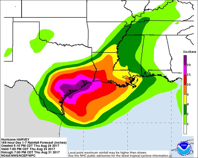
Up to 35 inches of rain possible over SE Texas through Wed
& could cause life-threatening flash flooding
http://hurricanes.gov #Harvey
Old as dirt
Old as dirt
I tried to edit the Thread Heading when I first started it. It wouldn't let me. I've never tried to edit a Heading before. Maybe a Mod will fix it to fit the new developments. Thanks, all. I went to town earlier to get food stuff we were out of. Plenty of stock on the shelves now. Then I back tracked to the liquor store. Now I think I need to go get a jug or two of gasoline.
Shit, this is starting to look like the lead up to Hurricane Rita that hit here in 2005. First they said it was going to Corpus, then it was Angelton, then Galveston, then Bolivar. The next morning, I got up to hear the local weatherman say, that we need to get out now.
Oh my God don't mention Rita, Tore the living hell out of our home, New roof, Tree's down everywhere ,
Old as dirt
Old as dirt
Just heard the local weather, According to Boswick Channel 6 news, its going to stall and just make a mess of everything, Then may even move back into the gulf and regain its strength and head East up the coast. We are looking at a monster maybe.
Old as dirt
Old as dirt
Well, this gets my mind off all the turmoil going on in our country.
I can think of better ways to get our mind off of our country problems.
I went to Wall mart, Wall to wall customers. Gassed up the car, and will ride out what ever, Stay safe Txkstew.
Bubble Head
Has No Life - Lives on TB
I tried to edit the Thread Heading when I first started it. It wouldn't let me. I've never tried to edit a Heading before. Maybe a Mod will fix it to fit the new developments. Thanks, all. I went to town earlier to get food stuff we were out of. Plenty of stock on the shelves now. Then I back tracked to the liquor store. Now I think I need to go get a jug or two of gasoline.
Shit, this is starting to look like the lead up to Hurricane Rita that hit here in 2005. First they said it was going to Corpus, then it was Angelton, then Galveston, then Bolivar. The next morning, I got up to hear the local weatherman say, that we need to get out now.
Dennis gave me a lesson last week. Just go to edit and hit advance. Saves you an encounter with Dennis.
The data from the 18z run will be the most critical in predicting landfall strength.
The eyewall is still not completely enveloped, which is good news. However, if it closes soon it could intensify quickly before midnight. Hopefully it will hold off for a few more hours.
The flanking in the system is dragging this system northward more than the model showed 2-3 hours ago. It is also now fighting some dry air from the north.
I think the weather channel is being dramatic again like they did for hurricane Matthew. You know the one that was going to destroy Disneyland.
Reed Timmer says this storm is going to be BAD!
Warm Wisconsin
Easy as 3.141592653589..
Reed Timmer says this storm is going to be BAD!
If the pressure on the next fly over are sub 960's I will jump on board for a Cat 3. However, the pressures would need sub 952 for this storm to get to Cat 4. All I'm saying is these guys get paid to have people watch them because they are consumed with fear. The NWS still says Cat 3 at most. The TV people are saying "it's the end of the world".
TheSearcher
Are you sure about that?
If the pressure on the next fly over are sub 960's I will jump on board for a Cat 3. However, the pressures would need sub 952 for this storm to get to Cat 4. All I'm saying is these guys get paid to have people watch them because they are consumed with fear. The NWS still says Cat 3 at most. The TV people are saying "it's the end of the world".
A cat 3 is bad enough. Let's stow the napalm hairjel for a little longer, I do agree.
somdwatcher
Veteran Member
Recon plane is in Harvey now and pressure has dropped to at least 972mb and they are not at the center.
Possible Impact
TB Fanatic
If the pressure on the next fly over are sub 960's I will jump on board for a Cat 3. However, the pressures would need sub 952 for this storm to get to Cat 4. All I'm saying is these guys get paid to have people watch them because they are consumed with fear. The NWS still says Cat 3 at most. The TV people are saying "it's the end of the world".
[FONT=Verdana,Arial]
Natl Hurricane Ctr [/FONT] http://www.nhc.noaa.gov/
Last update Fri, 25 Aug 2017 00:00:28 UTC
7:00 PM CDT Thu Aug 24
Location: 25.0°N 94.3°W
Moving: NW at 10 mph
Min pressure: 974 mb
Max sustained: 85 mph