Lilbitsnana
On TB every waking moment
Oh my gosh, one of the hotels deemed the safest place to be (didn't catch which town) that a lot of media are staying in, had a large section of the siding blown off!
Apparently this hotel is in Clear Lake.

Oh my gosh, one of the hotels deemed the safest place to be (didn't catch which town) that a lot of media are staying in, had a large section of the siding blown off!
Yes, I see. You are definitely the Sassy in the better location!
Take care Blue. Wish I was with Sassy in AZ right now!
Will pray for your friends/family, you, me, us and everybody.
I am about to lose power I think - it's flickering.
SpeckledTrout, I don't think they're going to get rescued. The rescuers said they were shutting down. It's dark with hurricane winds there now and it's too dangerous.
Dear God, I know they were acting stupid but I can't imagine the terror they are experiencing now.
Maybe I have more compassion because when I was young I did a dumb thing during a Nor'Easter that got our picture on the front page of the Boston paper. We could have been killed. Lesson learned. So I'll be praying for some miracles.
Take care Blue. Wish I was with Sassy in AZ right now!
Will pray for your friends/family, you, me, us and everybody.
I am about to lose power I think - it's flickering.
KHOU reporting rooftop clingers on Crystal Beach. 3 on top of Seaside Lumber and 15 at the church across the street (tied together).
Yes they stopped heli rescues a while ago after getting 95.
Sorry I didn't see your post, edited to include it.
Agreed, Celtic Rose!
BlueNewton, I pray your family members make it through tonight and tomorrow. I will be praying along with you that they are safe in a hospital shelter somewhere.
Here in Texarkana, we had one hell of a rain storm about 5:30 this afternoon. Its the first of the rain bands from the hurricane to come thru here. It is amazing to be this far inland and be under a tropical storm warning for the next 24 hours.
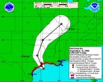
on another note, before I left to go to my daughter's volleyball game around 5:00 or so this afternoon, the talking heads on either FOX or MSNBC had a meteorologist on from the National Weather/Hurricane Center and he said that the position of the storm was setting up a "tsunami" type event for the shipping canal that goes into Houston. He went on to comment that the water would be funneled down that channel and with the winds driving it they couldn't speculate how how the wave would be but that the devastation would be immense.
Anybody heard anything more about this?
ETA: you Sassys take care too!
Houston Chronicle has a good slide show on its front page (on the left - click on the pic of the dude in waders) - one is a 'wow' artsy photo of waves in Galveston crashing over the memorial to the old Galveston hurricane.
http://www.chron.com/
I can't belive that anyone could look at these photos and not be completely stunned. The wind is hardly blowing yet in the vast majority. But the water is already several feet high. And I wonder how many folks standing on the Galveston Seawall to watch the water come in will be washed out to sea. Frightening photos.
Thank you very much for your kind thoughts, Mole.
sassy.....
Take good care.....
Jarhead

I will. Thanks again for all of your updates.
They are saying that there is a house fire on the west end of Galveston now and it is jumping from house to house. The fire dept cannot get to it.
BlueNewton, I pray your family members make it through tonight and tomorrow. I will be praying along with you that they are safe in a hospital shelter somewhere.
Here in Texarkana, we had one hell of a rain storm about 5:30 this afternoon. Its the first of the rain bands from the hurricane to come thru here. It is amazing to be this far inland and be under a tropical storm warning for the next 24 hours.
on another note, before I left to go to my daughter's volleyball game around 5:00 or so this afternoon, the talking heads on either FOX or MSNBC had a meteorologist on from the National Weather/Hurricane Center and he said that the position of the storm was setting up a "tsunami" type event for the shipping canal that goes into Houston. He went on to comment that the water would be funneled down that channel and with the winds driving it they couldn't speculate how how the wave would be but that the devastation would be immense.
Anybody heard anything more about this?
ETA: you Sassys take care too!
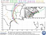
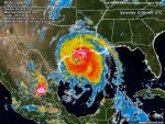
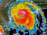
NWS/NHC reporting that Ike is approx. 600 miles wide! Whoo...
Jarhead
Ok, while I still have power I have to ask...
Everybody is sitting outside right now and we are seeing something I have never seen before..
The sky is lighting up pink, orange and blue!
Incredible show...no lightning or thunder....just entire sky lighting up in neon type colors
What is that?
I'm not sure I believe that.