
You are using an out of date browser. It may not display this or other websites correctly.
You should upgrade or use an alternative browser.
You should upgrade or use an alternative browser.
Volcano Update 2 - Additional vents opening -Volcano on La Palma island in the Canary Islands has erupted
- Thread starter Warm Wisconsin
- Start date
packyderms_wife
Neither here nor there.
Someone asked earlier what to look for. To the best of my knowledge the North Atlantic doesn't have the tidal wave bowies that the Pacific has. I would bookmark live beach view from the Azores and the Bahamas. If you see the tidal wave hit the Bahamas, the East coast of the US has about 45 minutes, or less, depending on where you are...
Maybe the USGS should be installing more!
danielboon
TB Fanatic
Last edited:
packyderms_wife
Neither here nor there.
what are we looking for in this photo?
Walrus Whisperer
Hope in chains...
what are we looking for in this photo?

mudlogger
Veteran Member
The two pics are taken from the same location...see the road sign on the left. They're showing the pre-volcano and the current view.what are we looking for in this photo?
skwentnaflyer
Veteran Member
packyderms_wife
Neither here nor there.
The two pics are taken from the same location...see the road sign on the left. They're showing the pre-volcano and the current view.
Thank you!
danielboon
TB Fanatic
yesBefore and after?
packyderms_wife
Neither here nor there.
That's a significant change in the landscape there!
danielboon
TB Fanatic
indeedThat's a significant change in the landscape there!
Walrus Whisperer
Hope in chains...
Look at all the dead trees in right photo.... Toxic fumes I guess.
The views are different, the left one is further away, the right quite a bit closer, looks like the same road....
The views are different, the left one is further away, the right quite a bit closer, looks like the same road....
danielboon
TB Fanatic
Yes that's a new mountainIs that a wall of lava? A new mountain????
Martinhouse
Deceased
Looks like the same mountains to me, just lots closer in the picture on the right. Other than all the dead vegetation, the big difference I can see is it looks like the road is all torn up, like maybe even big slabs of the pavement pushed around.
Mprepared
Veteran Member
This might be the same road, but in the video, huge lava floating on by.
View: https://www.youtube.com/watch?v=oavSNNzXAuo
danielboon
TB Fanatic
Jimbopithecus
Deceased
Rhe borthern quarter of the island reportedly uplifted 18 cm
overnight.
overnight.
Last edited:
Jimbopithecus
Deceased
deletedRhe borthern quarter of the island reportedly uplifted 18 c
overnight.
Lone_Hawk
Resident Spook
Well, Hal has a tendency to jump, but he is referencing official info. Also he has misplaced the ridge that is the issue and shows it to be way south of where it is, which is north of the active vents.

However, having said that, the area that is lifting is a concern for sure.
However, having said that, the area that is lifting is a concern for sure.
packyderms_wife
Neither here nor there.
Well, Hal has a tendency to jump, but he is referencing official info. Also he has misplaced the ridge that is the issue and shows it to be way south of where it is, which is north of the active vents.
However, having said that, the area that is lifting is a concern for sure.
Well, I don't want to freak people out, however, this volcano is following an eerily similar path that Tambora took, and we all know how that worked out.
Lone_Hawk
Resident Spook
Looking at the picture again, the Western coastal areas that have dropped 10cm is also a concern in that is a significant shifting of the island. Makes me wonder what is happening under the surface on the ocean floor. I think I will try to see if there is any sat radar imaging going on in the area... Hmmm
packyderms_wife
Neither here nor there.
Looking at the picture again, the Western coastal areas that have dropped 10cm is also a concern in that is a significant shifting of the island. Makes me wonder what is happening under the surface on the ocean floor. I think I will try to see if there is any sat radar imaging going on in the area... Hmmm
Good questions. I see quakes are still popping off in the Sandwich Island region not far off the coast of Antartica. and have been wondering if this is affecting La Palma any.
Doc1
Has No Life - Lives on TB
I've been watching the live streams and the lava streams and explosive ejections have increased in intensity quite a bit this afternoon (our time). Apparently the northern section of the island has risen by 10 to 15 centimeters today and the lower have has sunk by at least several centimeters.
Some of you may recall that I posted several days ago about a conversation I had with a geologist friend. At that time, he placed the odds of the lower western half of the island falling into the sea at 50-50. He called me this afternoon and has upped his personal odds to 60%.
That part of the island cleaving into the sea is what is predicted to cause the catastrophic tsunami which would take out the Eastern Seaboard and communities around the entire Gulf of Mexico.
Board members should keep a close eye on this. If it lets go, those in affected zones will have at least several hours to get to higher ground. I'm not predicting that this will happen, but if it does, you will only have a very narrow window of opportunity before the roads become parking lots.
DW and I are about fifty miles north of the GOM coast and are at approximately 250' above sea level. We're still considering our options, as our location is not - apparently - in critical danger, but who knows...
Best
Doc
Krayola
Veteran Member
Did your geologist friend give a time frame?I've been watching the live streams and the lava streams and explosive ejections have increased in intensity quite a bit this afternoon (our time). Apparently the northern section of the island has risen by 10 to 15 centimeters today and the lower have has sunk by at least several centimeters.
Some of you may recall that I posted several days ago about a conversation I had with a geologist friend. At that time, he placed the odds of the lower western half of the island falling into the sea at 50-50. He called me this afternoon and has upped his personal odds to 60%.
That part of the island cleaving into the sea is what is predicted to cause the catastrophic tsunami which would take out the Eastern Seaboard and communities around the entire Gulf of Mexico.
Board members should keep a close eye on this. If it lets go, those in affected zones will have at least several hours to get to higher ground. I'm not predicting that this will happen, but if it does, you will only have a very narrow window of opportunity before the roads become parking lots.
DW and I are about fifty miles north of the GOM coast and are at approximately 250' above sea level. We're still considering our options, as our location is not - apparently - in critical danger, but who knows...
Best
Doc
Doc1
Has No Life - Lives on TB
Doomer Doug
TB Fanatic
Well, here is a link to LIVE VIDEO FEEDS OF THE ACTUAL ERUPTION. AMAZING AND AWE INSPIRING.
View: https://www.youtube.com/watch?v=XLeYZY6VVAw
LIVE: La Palma Volcano Eruption in the Canary Islands (Feed #1) 105
LIVE: La Palma Volcano Eruption in the Canary Islands (Feed #1) 105
Doomer Doug
TB Fanatic
For the megatsunami, rock slide etc etc you need all of this stuff that is now happening in the middle and southern part of the island to MOVE NORTH.
If that starts to happen, and you can see the quakes increase in number, intensity and start to happen shallower and under the NORTHERN PART OF THE ISLAND, then Doc1 can hold his horses, cows, chickens or anything else he can get his paws on.
The volcanic eruption is not calming down as far as I can tell, but I will check with "my guy," diamond from Magnetic Reversal and see what is going on tonight.
Lilbitsnana
On TB every waking moment
Well, Hal has a tendency to jump, but he is referencing official info. Also he has misplaced the ridge that is the issue and shows it to be way south of where it is, which is north of the active vents.
However, having said that, the area that is lifting is a concern for sure.
It is the Southern part of the island that has the rift/fault or whatever you want to call it running thru the top of the ridge that has always been the concern for the massive landslide and that the Western part is what would slide. I think I had posted a map that shows it and the area of concern. Basically, it was like drawing a line North to South down the middle of island and most of the bottom half to 2/3rds of the island West of the line is what would eventually collapse/slide off.
As far as the lift, I had posted something a few weeks ago that a scientist form the Spanish Institute had talked about how the weight of the lava would cause uplift in areas where the lava wasn't while other parts where the lava flows are going would actually end up sinking lower due to the weight.
His point was that the island is basically one island built on three volcanoes/pillars, but that they share part of the lower common starting point of lava. (ha, best I could get from translate while I was reading/listening to what he had said)
He did mention that it was possible that new vents would open farther North or that the volcano on the Northern part could become active again. (it was hard to follow sometimes)
So two possible reasons for uplift. (magma inflow and/or gravity/weight)
I wish I could find all the info I had thought I had saved, but apparently didn't save.
I found a report from several years ago that is along the lines of his discussion.
The info at the first link is several years old, but the map on page nine shows where the weak line is, although the professor I watched on a livestream had said new data shows it does or might actually extends to or almost to the salt mines...they are at the Southern tip of the country.
page 9 has the map (12 page pdf)
different map/source :
Don't think this map/image can paste, but posting link (above). It gives a quick idea of why the professor had said to think of three support columns coming from one source that creates the island, but overall, the danger part is actually much larger the tiny section marked as Cumbre Nueva. The danger part is shown on left image, although as I said the professor thinks it actually extends farther South. The right image shows the names of the three volcanic systems (support columns).
Last edited:
Lilbitsnana
On TB every waking moment
For the megatsunami, rock slide etc etc you need all of this stuff that is now happening in the middle and southern part of the island to MOVE NORTH.
If that starts to happen, and you can see the quakes increase in number, intensity and start to happen shallower and under the NORTHERN PART OF THE ISLAND, then Doc1 can hold his horses, cows, chickens or anything else he can get his paws on.
The volcanic eruption is not calming down as far as I can tell, but I will check with "my guy," diamond from Magnetic Reversal and see what is going on tonight.
It is not the Northern part that was ever said it was going to collapse/slide off.
Do you have a link that shows that is the part that was predicted to eventually slide/collapse? I have never seen one, but lots and lots showing the lower 2/3rds or Western section.
Lone_Hawk
Resident Spook
It is not the Northern part that was ever said it was going to collapse/slide off.
Do you have a link that shows that is the part that was predicted to eventually slide/collapse? I have never seen one, but lots and lots showing the lower 2/3rds or Western section.
The ridge line in both of the documents, the dotted line in the first and red line in the second. That is where I saw that there was a fault. The largest mass of land that could slide is north of the current eruption. All of this is one environment that is affecting the rest of it. Now if the whole damn thing lets go it is going to be a big, big, problem.
Doomer Doug
TB Fanatic
I have never said there would be a megatsunami from this eruption since it is miles south of where the 1949 slide started.
To get a megatsunami the quakes would need to be shallower, stronger, and MUCH farther north and west. All this hype is bs. I could see from day 1 there was ZERO chhance of "the" rockslide because the eruption wasn't anywhere near the area needed to continue the 1949 rockslide.
To get a megatsunami the quakes would need to be shallower, stronger, and MUCH farther north and west. All this hype is bs. I could see from day 1 there was ZERO chhance of "the" rockslide because the eruption wasn't anywhere near the area needed to continue the 1949 rockslide.
Lilbitsnana
On TB every waking moment
The ridge line in both of the documents, the dotted line in the first and red line in the second. That is where I saw that there was a fault. The largest mass of land that could slide is north of the current eruption. All of this is one environment that is affecting the rest of it. Now if the whole damn thing lets go it is going to be a big, big, problem.
I think I posted this weeks ago, but great explanation of how and what portion would slide.
page 2 has the map and the slide area is very close to what the professor had talked a few weeks ago, but his went even farther to the East at the very Southern tip area than this one shows.
No eruption needed farther North as you suggested.
page 2 has map/breakdown of future slide.
Interesting that all of the quakes are getting bigger and vast majority of the quakes are in Southern area.
Three magnitude 4 plus in last 24 hours and only five total over last 30 days.
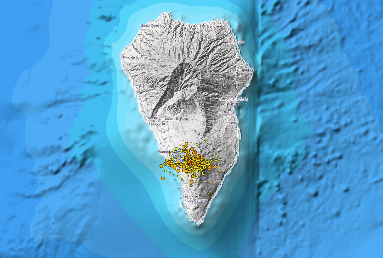
Earthquakes on La Palma Island This Month: List, Stats, & Map
Look up recent and past earthquakes on or near La Palma Island. See how many quakes there were in the past 30 days. Frequently updated list and interactive map, updates, links and background info.
www.volcanodiscovery.com
| Monday, October 11, 2021 03:10 GMT (3 earthquakes) | |||
| Sunday, October 10, 2021 23:44 GMT (67 earthquakes) | |||
| Oct 10, 2021 10:46 pm (GMT +1) (Oct 10, 2021 21:46 GMT) 6 hours ago | 4.3 39 km | La Palma Island, Canary Islands, Spain I FELT IT - 25 reports |
| Map | |||
| Oct 10, 2021 2:05 pm (GMT +1) (Oct 10, 2021 13:05 GMT) 15 hours ago | 4.0 38 km | La Palma Island, Canary Islands, Spain I FELT IT - 1 report |
| Map | |||
| Oct 10, 2021 12:54 pm (GMT +1) (Oct 10, 2021 11:54 GMT) 16 hours ago | 4.1 37 km | Tenerife, Canary Islands, Spain I FELT IT - 13 reports |
| Map | |||
| Saturday, October 9, 2021 23:32 GMT (44 earthquakes) | |||
| Friday, October 8, 2021 23:55 GMT (20 earthquakes) | |||
| Oct 9, 2021 12:55 am (GMT +1) (Oct 8, 2021 23:55 GMT) 2 days ago | 4.2 38 km | La Palma Island, 12 km southeast of Los Llanos de Aridane, Spain I FELT IT - 9 reports |
| Map | |||
| Thursday, October 7, 2021 23:31 GMT (27 earthquakes) | |||
| Oct 7, 2021 12:17 pm (GMT +1) (Oct 7, 2021 11:17 GMT) 4 days ago | 4.3 35 km | La Palma Island, 12 km south of Santa Cruz de La Palma, Spain I FELT IT - 24 reports |

Lilbitsnana
On TB every waking moment
Thank you Kayak.
My computer or maybe the way I was trying to do it, kept giving me different error messages.
My computer or maybe the way I was trying to do it, kept giving me different error messages.
Lilbitsnana
On TB every waking moment
Interesting livestream showing volcano plus three insets of comparison: last night, yesterday and two days ago.
View: https://www.youtube.com/watch?v=-f_xPnRlPoM