
You are using an out of date browser. It may not display this or other websites correctly.
You should upgrade or use an alternative browser.
You should upgrade or use an alternative browser.
Solar Solar Weather and Space News 2024
- Thread starter packyderms_wife
- Start date

Tom McDowell
BAMN
RT 03:51

Suspicious0bservers
743K subscribers
===
.
SIX SOLAR STORMS ON THEIR WAY TO EARTH | S0 News May.10.2024
Suspicious0bservers
743K subscribers
===
.
Blacknarwhal
Let's Go Brandon!
I’m expecting satellites to be wiggy and that’s it.
ETA meaning I might not get to stream online shows and this is why I bought a blue ray dvd player recently! Ummm yeah.
I can certainly do without the internet for a night if needs be. Especially on the weekend when I'm not working.
DannyBoy
Veteran Member
And interestingly, iirc, after the last "X" eclipses over the USA, in the mid 1800's there was a major New Madrid earthquake... seems like it was a few weeks later. That was the one where the Mississippi ran backwards for a while. That along with the plasma punch might be additive as far as earthquake stuff... hmmm...No, we're not all going to die. No, I don't think it'll be an EMP type event. I would expect some weird satellite things going on, so if you go grocery shopping don't be surprised of the computer operated cash register might not work... ditto on getting gas. I'm expecting it to be random, not nation wide.
As for multiple X flares coming at us, these are small in comparison to the Carrington Event. However, because our magnetosphere is growing weaker, repeated small class X flares would be like an EF1 tornado going over a town, circling back, and doing that repeatedly. Eventually something is going to break from the stress.
I myself am more concerned about a major earthquake happening as a result of these X flares hitting the planet.
Last edited:
tech
Veteran Member
ALERT: X-Ray Flux exceeded M5
Threshold Reached: 2024 May 10 1407 UTC
NOAA Scale: R2 - Moderate
www.swpc.noaa.gov/noaa-scales-explanation
Potential Impacts: Area of impact centered on sub-solar point on the sunlit side of Earth. Extent of blackout of HF (high frequency) radio communication dependent upon current X-ray Flux intensity.
Do you know the actual dates of those last x eclipses?And interestingly, iirc, after the last "X" eclipses over the USA, in the mid 1800's there was a major New Madrid earthquake... seems like it was a few weeks later. That was the one where the Mississippi ran backwards for a while. That along with the plasma punch might be additive as far as earthquake stuff... hmmm...
packyderms_wife
Neither here nor there.
And interestingly, iirc, after the last "X" eclipses over the USA, in the mid 1800's there was a major New Madrid earthquake... seems like it was a few weeks later. That was the one where the Mississippi ran backwards for a while. That along with the plasma punch might be additive as far as earthquake stuff... hmmm...
1811/1812 and lets not speak of this lest mother nature should get any ideas!
tech
Veteran Member
Just out:
Space Weather Message Code: WARSUD
Serial Number: 222
Issue Time: 2024 May 10 1647 UTC
WARNING: Geomagnetic Sudden Impulse expected
Valid From: 2024 May 10 1700 UTC
Valid To: 2024 May 10 1730 UTC
IP Shock Passage Observed: 2024 May 10 1639 UTC
www.swpc.noaa.gov/noaa-scales-explanation
Space Weather Message Code: WARSUD
Serial Number: 222
Issue Time: 2024 May 10 1647 UTC
WARNING: Geomagnetic Sudden Impulse expected
Valid From: 2024 May 10 1700 UTC
Valid To: 2024 May 10 1730 UTC
IP Shock Passage Observed: 2024 May 10 1639 UTC
www.swpc.noaa.gov/noaa-scales-explanation
John Deere Girl
Veteran Member
View: https://twitter.com/SunWeatherMan/status/1788986460038701296

SpaceWeatherNews
@SunWeatherMan
The first impact struck as I was on live with Alex Jones, it appears we are going to hit level three from just this first event. That is not good
SpaceWeatherNews
@SunWeatherMan
The first impact struck as I was on live with Alex Jones, it appears we are going to hit level three from just this first event. That is not good
DannyBoy
Veteran Member
Sorry, just remember they were the mid 1800's? see if I can find something quickly...Do you know the actual dates of those last x eclipses?
Yup, looks like 1811 and 1812... I think the two eclipses were earlier in the year 1811... but looks like they did not make an X over the US... maybe depends on how you consider the path...
Earthquake causes fluvial tsunami in the Mississippi River | February 7, 1812 | HISTORY
On February 7, 1812, the most violent of a series of earthquakes near Missouri causes a so-called fluvial tsunami in the Mississippi River, actually making the river run backward for several hours. The series of tremors, which took place between December 1811 and March 1812, were the most...
On February 7, 1812, the most violent of a series of earthquakes near Missouri causes a so-called fluvial tsunami in the Mississippi River, actually making the river run backward for several hours. The series of tremors, which took place between December 1811 and March 1812, were the most powerful in the history of the United States.
The unusual seismic activity began at about 2 a.m. on December 16, 1811, when a strong tremor rocked the New Madrid region. The city of New Madrid, located near the Mississippi River in present-day Missouri, had about 1,000 residents at the time, mostly farmers, hunters and fur trappers. At 7:15 a.m., an even more powerful quake erupted, now estimated to have had a magnitude of 8.6. This tremor literally knocked people off their feet and many people experienced nausea from the extensive rolling of the earth. Given that the area was sparsely populated and there weren’t many multi-story structures, the death toll was relatively low. However, the quake did cause landslides that destroyed several communities, including Little Prairie, Missouri.

Featured
How a Trio of Hellish Earthquakes Prompted America’s First Disaster Relief Act
When the New Madrid earthquakes rattled the Midwest in 1811 and 1812, William Clark, of the Lewis and Clark Expedition, convinced the government to step in.Read more
Read more about How a Trio of Hellish Earthquakes Prompted America’s First Disaster Relief Act
The earthquake also caused fissures—some as much as several hundred feet long—to open on the earth’s surface. Large trees were snapped in two. Sulfur leaked out from underground pockets and river banks vanished, flooding thousands of acres of forests. On January 23, 1812, an estimated 8.4-magnitude quake struck in nearly the same location, causing disastrous effects. Reportedly, the president’s wife, Dolley Madison, was awoken by the tremor in Washington, D.C. Fortunately, the death toll was smaller, as most of the survivors of the first earthquake were now living in tents, in which they could not be crushed.
The strongest of the tremors followed on February 7. This one was estimated at an amazing 8.8-magnitude, a reading that ranks among the strongest quakes in human history. Church bells rang in Boston, thousands of miles away, from the shaking. Brick walls were toppled in Cincinnati. In the Mississippi River, water turned brown and whirlpools developed suddenly from the depressions created in the riverbed. Waterfalls were created in an instant; in one report, 30 boats were helplessly thrown over falls, killing the people on board. Many of the small islands in the middle of the river, often used as bases by river pirates, permanently disappeared. Large lakes, such as Reelfoot Lake in Tennessee and Big Lake at the Arkansas-Missouri border, were created by the earthquake as river water poured into new depressions.
This series of large earthquakes ended in March, although there were aftershocks for a few more years. In all, it is believed that approximately 1,000 people died because of the earthquakes, though an accurate count is difficult to determine because of a lack of an accurate record of the Native American population in the area at the time.
Then this one...

The Great Midwest Earthquake of 1811
Two hundred years ago, a series of powerful temblors devastated what is now Missouri. Could it happen again?
 www.smithsonianmag.com
The Great Midwest Earthquake of 1811
Two hundred years ago, a series of powerful temblors devastated what is now Missouri. Could it happen again?
Elizabeth Rusch
December 2011
/https://tf-cmsv2-smithsonianmag-media.s3.amazonaws.com/filer/Phenomena-earthquake-central-631.jpg "New Madrid earthquake")
At 2:15 a.m. on December 16, 1811, residents of the frontier town of New Madrid, in what is now Missouri, were jolted from their beds by a violent earthquake. The ground heaved and pitched, hurling furniture, snapping trees and destroying barns and homesteads. The shaking rang church bells in Charleston, South Carolina, and toppled chimneys as far as Cincinnati, Ohio.
“The screams of the affrighted inhabitants running to and fro, not knowing where to go, or what to do—the cries of the fowls and beasts of every species—the cracking of trees falling...formed a scene truly horrible,” wrote one resident.
As people were starting to rebuild that winter, two more major quakes struck, on January 23 and February 7. Each New Madrid earthquake had a magnitude of 7.5 or greater, making them three of the most powerful in the continental United States and shaking an area ten times larger than that affected by the magnitude 7.8 San Francisco earthquake of 1906.
The Midwest was sparsely populated, and deaths were few. But 8-year-old Godfrey Lesieur saw the ground “rolling in waves.” Michael Braunm observed the river suddenly rise up “like a great loaf of bread to the height of many feet.” Sections of riverbed below the Mississippi rose so high that part of the river ran backward. Thousands of fissures ripped open fields, and geysers burst from the earth, spewing sand, water, mud and coal high into the air.
Geologists once assumed that the 1811-12 disaster was a one-time event and little cause for concern for the people who now live near the epicenter. Then, two decades ago, paleoseismology expert Martitia Tuttle and her colleagues began dissecting “sand blows” in the five states surrounding New Madrid. The sand blows were left by geysers when debris surged up through narrow dikes and landed in wide mounds. “Sand blows tell a dramatic story of the widespread shaking of these large earthquakes,” she says.
Tuttle’s team excavated potsherds, spear points and corn kernels and realized that many of the sand blows were more than 200 years old. “Some had archaeological sites on top of them with 2,000-year-old artifacts,” Tuttle says. “There’s no way the New Madrid earthquakes were a one-time freak event.” The Midwest had been slammed by violent quakes around A.D. 1450 and 900 and 2350 B.C.—and probably more often.
Most earthquakes occur at the edges of the earth’s 15 major tectonic plates; when they slide against each other, the ground gets a jolt. But New Madrid sits in the middle of a plate. Its seismic history—and the magnitude 5.8 Virginia quake that shook the East Coast earlier this year—is a reminder that earthquakes can strike in surprising places.
Plate interiors are riddled with ancient faults. Beatrice Magnani wants to find out why some, like New Madrid’s, are still seismically active. Early one morning, Magnani, a seismologist at the University of Memphis, guided a steel cylindrical air gun from a tugboat into the silty waters of the Mississippi River and then tested it. Boom! Everyone onboard felt, more than heard, the shot. Muddy water rippled, and a bubble bigger than a coffee table rose to the surface. Sound waves from the air gun traveled to the bottom of the river, then through the sludge and sediment to bedrock and a mile deep into the earth’s crust.
Magnani’s team dropped a large buoy off the tug with a splash. The buoy drifted downriver, dragging a 300-foot-long, two-inch-wide tube strung with microphones. A crane lifted what looked like a large yellow manta ray, an instrument called a Chirp, and lowered it into the water.
The Chirp started pinging, five times every second. The air gun blasted every seven seconds. When data from the microphones reached the computers onboard, they beeped. Ping, ping, ping, ping, Boom!, beep. The racket would continue for eight hours as the boat floated ten miles downriver.
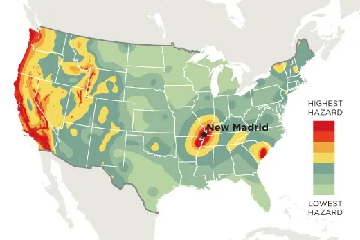
Over the past three years, Magnani has used these tools to map the ground below the river in the New Madrid Seismic Zone, a fault system stretching about 150 miles from Cairo, Illinois, to Marked Tree, Arkansas. It’s the most active seismic area in the United States east of the Rockies, with about 200 small quakes a year.
Magnani’s most startling discovery came south of the seismic zone: two faults, one near Memphis, both active in the past 10,000 years. Other researchers have recently identified faults near Commerce, Missouri, and other places outside the New Madrid Seismic Zone that have been active in the past few thousand to millions of years, suggesting that the middle of the country is less stable than it seems.
Geologists have long blamed the New Madrid earthquakes on the Reelfoot Rift, a 500-million-year-old area of weakness in the crust. But the newfound faults lie outside the rift. “Maybe the reason we haven’t been able to solve the mystery of the New Madrid earthquakes is that we’ve been too focused on New Madrid,” Magnani says. “Maybe earthquake activity moves around systematically over time.”
Tuttle has begun a four-year project to date sand blows inside and outside the New Madrid Seismic Zone. “We’ve got to get a solid understanding of what large earthquakes happened where and when,” she says. That’s the best way to estimate the hazard to the Midwest and its millions of people and countless highways, bridges, skyscrapers and crumble-prone brick buildings.
The U.S. Geological Survey estimates that the risk of another New Madrid-scale catastrophe in the next 50 years is about 7 to 10 percent. The risk of a smaller, though still devastating, 6.0 earthquake in the next 50 years is 25 to 40 percent. Ongoing research should help identify which areas are most in danger.
“We need a broader, yet clearer picture of all the networks of faults that have been active in the region,” says Magnani. “We need to find out how big they are and their underlying structures. That’s the only way we can hope to understand intraplate earthquakes—and ultimately keep people safe.”
Elizabeth Rusch wrote about extracting energy from ocean waves for Smithsonian.
1 / 3
The U.S. Geological Survey’s seismic hazard map is used to set building codes and plan for emergencies. Map: Guilbert Gates; Source: USGS National Seismic Hazard Maps, 2008
packyderms_wife
Neither here nor there.
Severe (G4) Geomagnetic Storm in Progress
May 10, 2024 @ 16:50 UTC (UPDATED)
One, or perhaps a combination of at least two coronal mass ejections just reached both the ACE and DSCOVR spacecrafts. The solar wind is fairly high nearing 700 km/s. A passage past our planet should take place within the next 45 minutes. Stay tuned.
Strong CME Impact:
A geomagnetic sudden impulse measuring 108 nT was detected around 17:00 UTC by ground based magnetometers. A geomagnetic storm is already in progress and reached the Severe (G4) threshold. The solar wind speed is above 700 km/s and the Bz component of the interplanetary magnetic field is shifting wildly. More to follow.
ALERT: Geomagnetic K-index of 8, 9-
Threshold Reached: 2024 May 10 1739 UTC
Synoptic Period: 1500-1800 UTC
Active Warning: Yes
NOAA Scale: G4 - Severe

SUMMARY: Geomagnetic Sudden Impulse
Observed: 2024 May 10 1645 UTC
Deviation: 108 nT
Station: Boulder

www.solarham.com
May 10, 2024 @ 16:50 UTC (UPDATED)
One, or perhaps a combination of at least two coronal mass ejections just reached both the ACE and DSCOVR spacecrafts. The solar wind is fairly high nearing 700 km/s. A passage past our planet should take place within the next 45 minutes. Stay tuned.
Strong CME Impact:
A geomagnetic sudden impulse measuring 108 nT was detected around 17:00 UTC by ground based magnetometers. A geomagnetic storm is already in progress and reached the Severe (G4) threshold. The solar wind speed is above 700 km/s and the Bz component of the interplanetary magnetic field is shifting wildly. More to follow.
ALERT: Geomagnetic K-index of 8, 9-
Threshold Reached: 2024 May 10 1739 UTC
Synoptic Period: 1500-1800 UTC
Active Warning: Yes
NOAA Scale: G4 - Severe
SUMMARY: Geomagnetic Sudden Impulse
Observed: 2024 May 10 1645 UTC
Deviation: 108 nT
Station: Boulder
www.solarham.com
packyderms_wife
Neither here nor there.

X3.9 Solar Flare / Radiation Storm
May 10, 2024 @ 08:50 UTC (UPDATED)
The largest solar flare yet produced by AR 3664 was just observed at 06:54 UTC. This X3.9 blast is associated with a Type II radio emission with an estimated velocity of 1248 km/s, along with a 10cm radio burst (TenFlare) measuring 900 SFU and lasting 16 minutes. A coronal mass ejection (CME) is now becoming visible and it appears the main bulk is heading to the west, but there will likely still be an Earth directed component. More to follow.
Click HERE for video.
Also click HERE for a summary video of the past few days.
Radiation Storm: The minor (S1) radiation storm threshold was reached at 13:35 UTC (May 10). This is possibly related to X3.9 flare this morning, or can also be due to a combination of all previous eruptions nearing Earth.
www.solarham.com
packyderms_wife
Neither here nor there.
| Special Space Weather Alert |
| May 10, 2024 @ 01:30 UTC |
| Severe (G4) Geomagnetic Storm Watch For the first time in nearly 20 years, a Severe (G4) geomagnetic storm watch has been issued by NOAA Space Weather Prediction Center. 
A number of strong solar flares around active sunspot region 3664 was responsible for at least four Earth directed plasma eruptions, better known as coronal mass ejections. They are expected to reach Earth begining late on May 10th and into 11th. The first two observed on May 8th following X1 and M8 solar flares may combine together for an initial first impact. This is expected to be followed up by additional impacts to Earth's geomagnetic field as the weekend moves along. Visible aurora will be likely for locations at middle latitudes should a strong (G3) to severe (G4) storm be observed as forecast. Sky watchers across Scandinavia, Northern Europe, UK, Canada, northern tier USA and Alaska should all be alert. Should a period of severe (G4) storming take place, locations as far south as Texas and California could see aurora on the horizon once dark outside. Other impacts during a severe geomagnetic storm include degraded HF radio propagation, some issues with power systems especially at high latitudes and satellite navigation issues. Please keep in mind that the forecast is subject to change depending on the CME impact strength and timing. Generally speaking, there should be no threat to humans here on our planet. |
| X2.2 Solar Flare and Severe Storm Watch |
| May 9, 2024 @ 09:10 UTC (UPDATED) |
| AR 3664 does it again with a long duration X2.2 solar flare peaking at 09:13 UTC (May 9). Coronal dimming is already evident meaning this flare will likely be the source of a fourth Earth directed CME. The geomagnetic storm watch for this weekend was upgraded to the Severe (G4) level and this latest event could add even more fuel to the storm. Aurora sky watchers even at middle latitudes rejoice, it could be a great weekend! Fourth Halo CME Confirmed: Updated coronagraph imagery following the X2.2 solar flare confirms that a fourth halo CME was produced and appears Earth directed. With now four plasma clouds expected to pass Earth, the chances for a severe geomagnetic storm this weekend just increased. ALERT: Type II Radio Emission Begin Time: 2024 May 09 0902 UTC Estimated Velocity: 1004 km/s |
www.solarham.com
packyderms_wife
Neither here nor there.
I even got an alert on my phone for severe geomagnetic storm just now lol
That’s a new one!
Yep, definitely wasn't on my Bingo card, not even the secret one, for this year!
psychgirl
Has No Life - Lives on TB
Kinda crazy, huh!Yep, definitely wasn't on my Bingo card, not even the secret one, for this year!
Blacknarwhal
Let's Go Brandon!
Kinda crazy, huh!
I stopped playing after assembling the postage stamp with "Secret Jew Tunnels under Manhattan" and "Guy Named 'Barbecue' In Charge of Haiti."

danielboon
TB Fanatic
Saw this on another forum 
packyderms_wife
Neither here nor there.
FIRST IMPACT - Level 4 Storm
RT 1:34 - SuspiciousObserversbw
Fringe Ranger
The essay in question: How the sun could wipe us outinteresting
packyderms_wife
Neither here nor there.
The essay in question: How the sun could wipe us out
Thanks!
pauldingbabe
The Great Cat
I stopped playing after assembling the postage stamp with "Secret Jew Tunnels under Manhattan" and "Guy Named 'Barbecue' In Charge of Haiti."
Yeah, you gotta stop drinking after that.
Crazysauce.
Zoner
Veteran Member
Ed Dowd reposted this. I listened to NOAA today speak to the Press.
This is a weekend event and no one really knows what will happen.
View: https://twitter.com/CollinRugg/status/1789001672779567541
This is a weekend event and no one really knows what will happen.
View: https://twitter.com/CollinRugg/status/1789001672779567541
danielboon
TB Fanatic

danielboon
TB Fanatic

danielboon
TB Fanatic


bw
Fringe Ranger
Presumably the color indicates the energy. Violet would be high energy, I'm guessing.so booful :: sigh ::
packyderms_wife
Neither here nor there.
Ed Dowd reposted this. I listened to NOAA today speak to the Press.
This is a weekend event and no one really knows what will happen.
View: https://twitter.com/CollinRugg/status/1789001672779567541
We hav a massive gas line going down our street, it's under the street, and I mean it is HUGE. The voltage control thing concerns me.

packyderms_wife
Neither here nor there.
| Extreme (G5) Storm Reached / Widespread Aurora |
| May 10, 2024 @ 21:45 UTC (UPDATED) |
| A severe geomagnetic storm continues with the Kp index nearing the Extreme (G5) storm threshold. Aurora is happening now across many locations even at lower latitudes where it is dark outside. For ham radio operators, 6 meters is currently j am packed with stations working via the aurora with very strong and distorted signals. Antennas to the north! Extreme (G5) Storm: For the first time since the great Halloween Storm of 2003, the Extreme (G5) Geomagnetic Storm threshold has been reached! ALERT: Geomagnetic K-index of 9 Threshold Reached: 2024 May 10 2254 UTC Synoptic Period: 2100-2400 UTC Active Warning: Yes NOAA Scale: G5 - Extreme Have aurora photos you would like to share? Please send to kevin@solarcycle24.com 
Aurora from Czech Republic courtesy of Martin Pavelek. Thank you for sharing! 
|
www.solarham.com