WEATHER Severe Weather for the Week of April 1st, 2024

Millwright

Knuckle Dragger
_______________
Starting to see a dozen or so chasers up that way.

I guess they got stirring, hit the hotel bar for a bloody mary and hit the road.
 
Last edited:

homecanner1

Veteran Member
Blowing sideways, coming down thick.

Its primary day in Wisc too.

And Brewers opening day.

Mom nature packing a punch.

It is hitting 75 in Louisville and this cold Canadian snow line will tangle down there brutally.

475A2AF3-0B48-4575-BACF-A36E9D054AC9.jpeg
 

Red Baron

Paleo-Conservative
_______________
I'm thinking it's just a wee bit chilly for things to really spin up into nasty storms.

Hopefully


The SPC has to play a more conservative hand for warnings.

The chasers are in the loop and have good insight. They spend their own money to go out and maybe get some footage that will sell.

If they aren't stacking up, then it's an indication that chances aren't as great as the SPC is saying.

The SPC will never admit it but they do consider population density, early season public awareness and day/night when issuing Convective Outlooks and Watches.

The current Moderate Risk may have been issued a little too early IMHO. Models did not resolve the ongoing storms very well which is producing a rather chaotic forecasting environment.

Supposedly the tornadic potential for OH/KY ramps up at around 6:00 pm tonight.

We'll see . . .
 

Millwright

Knuckle Dragger
_______________
A few more red boxes popping up.


validww.png
 

packyderms_wife

Neither here nor there.
Severe Weather Statement
National Weather Service Morristown TN
516 PM EDT Tue Apr 2 2024

TNC013-129-151-022200-
/O.CON.KMRX.TO.W.0001.000000T0000Z-240402T2200Z/
Morgan TN-Campbell TN-Scott TN-
516 PM EDT Tue Apr 2 2024

...A TORNADO WARNING REMAINS IN EFFECT UNTIL 600 PM EDT FOR NORTHERN
MORGAN...SOUTHWESTERN CAMPBELL AND CENTRAL SCOTT COUNTIES...

At 516 PM EDT, a severe thunderstorm capable of producing a tornado
was located 12 miles northwest of Wartburg, moving northeast at 50
mph.

HAZARD...Tornado and quarter size hail.

SOURCE...Radar indicated rotation.

IMPACT...Flying debris will be dangerous to those caught without
shelter. Mobile homes will be damaged or destroyed. Damage
to roofs, windows, and vehicles will occur. Tree damage is
likely.

This dangerous storm will be near...
Huntsville around 535 PM EDT.

Other locations impacted by this tornadic thunderstorm include Rugby,
Rugby State Park, Smokey Junction, Deerlodge, Honey Creek State Park,
Norma, Elgin, Robbins, Slick Rock, and Sunbright.

PRECAUTIONARY/PREPAREDNESS ACTIONS...

TAKE COVER NOW! Move to a basement or an interior room on the lowest
floor of a sturdy building. Avoid windows. If you are outdoors, in a
mobile home, or in a vehicle, move to the closest substantial shelter
and protect yourself from flying debris.

&&

LAT...LON 3624 8427 3616 8473 3624 8480 3630 8480
3633 8477 3633 8476 3634 8474 3635 8474
3635 8473 3637 8472 3637 8470 3640 8466
3642 8468 3654 8449
TIME...MOT...LOC 2116Z 240DEG 42KT 3625 8472

TORNADO...RADAR INDICATED
MAX HAIL SIZE...1.00 IN

$$

19
 

packyderms_wife

Neither here nor there.
Tornado Warning
WVC075-022145-
/O.NEW.KRLX.TO.W.0013.240402T2112Z-240402T2145Z/

BULLETIN - EAS ACTIVATION REQUESTED
Tornado Warning
National Weather Service Charleston WV
512 PM EDT Tue Apr 2 2024

The National Weather Service in Charleston West Virginia has issued a

* Tornado Warning for...
Southwestern Pocahontas County in northeastern West Virginia...

* Until 545 PM EDT.

* At 511 PM EDT, a severe thunderstorm capable of producing a tornado
was located over Leonard, or 9 miles north of Renick, moving east
at 45 mph.

HAZARD...Tornado and quarter size hail.

SOURCE...Radar indicated rotation.

IMPACT...Flying debris will be dangerous to those caught without
shelter. Mobile homes will be damaged or destroyed.
Damage to roofs, windows, and vehicles will occur. Tree
damage is likely.

* This dangerous storm will be near...
Marlinton around 520 PM EDT.

Other locations impacted by this tornadic thunderstorm include
Buckeye, Minnehaha Springs, Hillsboro, and Cranberry Mountain Nature
Center.

PRECAUTIONARY/PREPAREDNESS ACTIONS...

TAKE COVER NOW! Move to a basement or an interior room on the lowest
floor of a sturdy building. Avoid windows. If you are outdoors, in a
mobile home, or in a vehicle, move to the closest substantial shelter
and protect yourself from flying debris.

&&

LAT...LON 3808 7996 3806 7996 3806 8011 3804 8017
3805 8027 3811 8036 3819 8036 3824 7995
3809 7994
TIME...MOT...LOC 2111Z 267DEG 41KT 3812 8040

TORNADO...RADAR INDICATED
MAX HAIL SIZE...1.00 IN

$$

JP
 

packyderms_wife

Neither here nor there.
Tornado Warning
INC029-115-137-155-022200-
/O.NEW.KILN.TO.W.0024.240402T2114Z-240402T2200Z/

BULLETIN - EAS ACTIVATION REQUESTED
Tornado Warning
National Weather Service Wilmington OH
514 PM EDT Tue Apr 2 2024

The National Weather Service in Wilmington has issued a

* Tornado Warning for...
Ohio County in southeastern Indiana...
Southern Ripley County in southeastern Indiana...
Southwestern Dearborn County in southeastern Indiana...
Northwestern Switzerland County in southeastern Indiana...

* Until 600 PM EDT.

* At 513 PM EDT, radar indicated that a tornado-producing storm was
located 10 miles south of Vernon, moving east at 55 mph.

HAZARD...Damaging tornado and quarter size hail.

SOURCE...Law enforcement confirmed tornado.

IMPACT...Flying debris will be dangerous to those caught without
shelter. Mobile homes will be damaged or destroyed.
Damage to roofs, windows, and vehicles will occur. Tree
damage is likely.

* Locations impacted include...
Dillsboro, Pleasant, Fairview, Rexville, Benham, Moorefield,
Avonburg, Farmers Retreat, Friendship, Bear Branch, Cross Plains,
Mount Sterling, Jacksonville, and Olean.

PRECAUTIONARY/PREPAREDNESS ACTIONS...

To repeat, a tornado is on the ground. TAKE COVER NOW! Move to a
basement or an interior room on the lowest floor of a sturdy
building. Avoid windows. If you are outdoors, in a mobile home, or in
a vehicle, move to the closest substantial shelter and protect
yourself from flying debris.

To report severe weather, go to our website at weather.gov/iln and
submit your report via social media, when you can do so safely.

&&

LAT...LON 3907 8505 3879 8503 3879 8520 3892 8520
3891 8544 3896 8545
TIME...MOT...LOC 2113Z 250DEG 47KT 3883 8564

TORNADO...OBSERVED
MAX HAIL SIZE...1.00 IN

$$

McGinnis
 

packyderms_wife

Neither here nor there.
Tornado Warning
INC077-022200-
/O.NEW.KLMK.TO.W.0020.240402T2126Z-240402T2200Z/

BULLETIN - EAS ACTIVATION REQUESTED
Tornado Warning
National Weather Service Louisville KY
526 PM EDT Tue Apr 2 2024

The National Weather Service in Louisville has issued a

* Tornado Warning for...
Northeastern Jefferson County in south central Indiana...

* Until 600 PM EDT.

* At 526 PM EDT, a confirmed tornado was located 9 miles northwest of
Madison, moving northeast at 45 mph.

HAZARD...Damaging tornado.

SOURCE...Law enforcement confirmed tornado.

IMPACT...Flying debris will be dangerous to those caught without
shelter. Mobile homes will be damaged or destroyed.
Damage to roofs, windows, and vehicles will occur. Tree
damage is likely.

* This tornadic thunderstorm will remain over mainly rural areas of
northeastern Jefferson County, including the following locations...
Middlefork, Canaan, Five Points, Dupont, Belleview, Bryantsburg,
and Barbersville.

PRECAUTIONARY/PREPAREDNESS ACTIONS...

To repeat, a tornado is on the ground. TAKE COVER NOW! Move to a
basement or an interior room on the lowest floor of a sturdy
building. Avoid windows. If you are outdoors, in a mobile home, or in
a vehicle, move to the closest substantial shelter and protect
yourself from flying debris.

&&

LAT...LON 3883 8521 3883 8554 3888 8555 3888 8554
3891 8553 3891 8520
TIME...MOT...LOC 2126Z 245DEG 41KT 3888 8549

TORNADO...OBSERVED
MAX HAIL SIZE...<.75 IN

$$

Wilkins
 

packyderms_wife

Neither here nor there.
BULLETIN - EAS ACTIVATION REQUESTED
Tornado Warning
National Weather Service Louisville KY
535 PM EDT Tue Apr 2 2024

The National Weather Service in Louisville has issued a

* Tornado Warning for...
South central Clark County in south central Indiana...
Oldham County in central Kentucky...
North central Shelby County in central Kentucky...
Southwestern Henry County in central Kentucky...
Northern Jefferson County in central Kentucky...

* Until 600 PM EDT.

* At 535 PM EDT, a severe thunderstorm capable of producing a tornado
was located near Prospect, moving east at 45 mph.

HAZARD...Tornado.

SOURCE...Radar indicated rotation.

IMPACT...Flying debris will be dangerous to those caught without
shelter. Mobile homes will be damaged or destroyed.
Damage to roofs, windows, and vehicles will occur. Tree
damage is likely.

* This dangerous storm will be near...
Prospect around 540 PM EDT.
La Grange around 550 PM EDT.

Other locations impacted by this tornadic thunderstorm include
Buckner, Harmony Village, Watson, Ballardsville, Utica, River Ridge,
Centerfield, Crestwood, Orchard Grass Hills, and Tarascon.

PRECAUTIONARY/PREPAREDNESS ACTIONS...

TAKE COVER NOW! Move to a basement or an interior room on the lowest
floor of a sturdy building. Avoid windows. If you are outdoors, in a
mobile home, or in a vehicle, move to the closest substantial shelter
and protect yourself from flying debris.

&&

LAT...LON 3850 8528 3831 8526 3833 8571 3837 8573
3850 8532
TIME...MOT...LOC 2135Z 263DEG 37KT 3836 8566

TORNADO...RADAR INDICATED
MAX HAIL SIZE...<.75 IN

$$

Padgett
 

packyderms_wife

Neither here nor there.
Tornado Warning
INC079-022145-
/O.NEW.KIND.TO.W.0010.240402T2125Z-240402T2145Z/

BULLETIN - EAS ACTIVATION REQUESTED
Tornado Warning
National Weather Service Indianapolis IN
525 PM EDT Tue Apr 2 2024

The National Weather Service in Indianapolis has issued a

* Tornado Warning for...
Southeastern Jennings County in southeastern Indiana...

* Until 545 PM EDT.

* At 525 PM EDT, a confirmed tornado was located 9 miles southeast of
Vernon, or 21 miles east of Seymour, moving east at 45 mph.

HAZARD...Damaging tornado and quarter size hail.

SOURCE...Law enforcement confirmed tornado.

IMPACT...Flying debris will be dangerous to those caught without
shelter. Mobile homes will be damaged or destroyed.
Damage to roofs, windows, and vehicles will occur. Tree
damage is likely.

* This tornadic thunderstorm will remain over mainly rural areas of
southeastern Jennings County.

PRECAUTIONARY/PREPAREDNESS ACTIONS...

To repeat, a tornado is on the ground. TAKE COVER NOW! Move to a
basement or an interior room on the lowest floor of a sturdy
building. Avoid windows. If you are outdoors, in a mobile home, or in
a vehicle, move to the closest substantial shelter and protect
yourself from flying debris.

&&

LAT...LON 3893 8557 3899 8544 3891 8545 3891 8554
3888 8554 3888 8556 3889 8556
TIME...MOT...LOC 2125Z 248DEG 40KT 3888 8550

TORNADO...OBSERVED
MAX HAIL SIZE...1.00 IN

$$

KF
 

Red Baron

Paleo-Conservative
_______________
Multiple Confirmed Tornados!

--------
College of DuPage Meteorology
Severe Weather and Flash Flood Warnings

Note: This page will reload every 2 minutes. Warnings are listed with the most recent first.
Click on the station ID to bring up list of recent severe weather statements.

SVR T-STORM WARNING WILMINGTON OH - KILN 541 PM EDT TUE APR 2 2024
SVR T-STORM WARNING BLACKSBURG VA - KRNK 541 PM EDT TUE APR 2 2024
TORNADO WARNING LOUISVILLE KY - KLMK 538 PM EDT TUE APR 2 2024
TORNADO WARNING LOUISVILLE KY - KLMK 535 PM EDT TUE APR 2 2024
SVR T-STORM WARNING LOUISVILLE KY - KLMK 532 PM EDT TUE APR 2 2024
TORNADO WARNING LOUISVILLE KY - KLMK 526 PM EDT TUE APR 2 2024
TORNADO WARNING INDIANAPOLIS IN - KIND 525 PM EDT TUE APR 2 2024
TORNADO WARNING WILMINGTON OH - KILN 514 PM EDT TUE APR 2 2024
SVR T-STORM WARNING LOUISVILLE KY - KLMK 513 PM EDT TUE APR 2 2024
TORNADO WARNING CHARLESTON WV - KRLX 512 PM EDT TUE APR 2 2024
TORNADO WARNING MORRISTOWN TN - KMRX 507 PM EDT TUE APR 2 2024
SVR T-STORM WARNING PADUCAH KY - KPAH 404 PM CDT TUE APR 2 2024
TORNADO WARNING BLACKSBURG VA - KRNK 504 PM EDT TUE APR 2 2024
TORNADO WARNING LOUISVILLE KY - KLMK 454 PM EDT TUE APR 2 2024
TORNADO WARNING INDIANAPOLIS IN - KIND 453 PM EDT TUE APR 2 2024


packyderms_wife

Neither here nor there.
Tornado Warning
TNC013-151-022230-
/O.NEW.KMRX.TO.W.0002.240402T2144Z-240402T2230Z/

BULLETIN - EAS ACTIVATION REQUESTED
Tornado Warning
National Weather Service Morristown TN
544 PM EDT Tue Apr 2 2024

The National Weather Service in Morristown has issued a

* Tornado Warning for...
Campbell County in east Tennessee...
Southeastern Scott County in east Tennessee...

* Until 630 PM EDT.

* At 543 PM EDT, a confirmed large and extremely dangerous tornado
was located near Huntsville, or 11 miles southeast of Oneida,
moving northeast at 35 mph.

This is a PARTICULARLY DANGEROUS SITUATION. TAKE COVER NOW!

HAZARD...Damaging tornado.

SOURCE...Public confirmed tornado.

IMPACT...You are in a life-threatening situation. Flying debris
may be deadly to those caught without shelter. Mobile
homes will be destroyed. Considerable damage to homes,
businesses, and vehicles is likely and complete
destruction is possible.

* This tornadic thunderstorm will remain over mainly rural areas of
Campbell and southeastern Scott Counties, including the following
locations... Jellico, Elk Valley, Indian Mountain State Park,
Fincastle, Royal Blue, White Oak, Norma, and Caryville.

This includes Interstate 75 in Tennessee between mile markers 138 and
161.

PRECAUTIONARY/PREPAREDNESS ACTIONS...

To repeat, a large, extremely dangerous and potentially deadly
tornado is on the ground. To protect your life, TAKE COVER NOW! Move
to a basement or an interior room on the lowest floor of a sturdy
building. Avoid windows. If you are outdoors, in a mobile home, or in
a vehicle, move to the closest substantial shelter and protect
yourself from flying debris.

Torrential rainfall is occurring with this storm, and may lead to
flash flooding. Do not drive your vehicle through flooded roadways.

&&

LAT...LON 3659 8398 3657 8398 3647 8394 3646 8393
3643 8392 3643 8390 3642 8390 3626 8447
3640 8455 3659 8422
TIME...MOT...LOC 2143Z 242DEG 32KT 3637 8442

TORNADO...OBSERVED
TORNADO DAMAGE THREAT...CONSIDERABLE
MAX HAIL SIZE...1.50 IN

$$

19
 

packyderms_wife

Neither here nor there.
Tornado Warning
KYC103-022230-
/O.NEW.KLMK.TO.W.0022.240402T2156Z-240402T2230Z/

BULLETIN - EAS ACTIVATION REQUESTED
Tornado Warning
National Weather Service Louisville KY
556 PM EDT Tue Apr 2 2024

The National Weather Service in Louisville has issued a

* Tornado Warning for...
Henry County in central Kentucky...

* Until 630 PM EDT.

* At 556 PM EDT, a severe thunderstorm capable of producing a tornado
was located near La Grange, moving east at 55 mph.

HAZARD...Tornado.

SOURCE...Radar indicated rotation.

IMPACT...Flying debris will be dangerous to those caught without
shelter. Mobile homes will be damaged or destroyed.
Damage to roofs, windows, and vehicles will occur. Tree
damage is likely.

* This dangerous storm will be near...
New Castle around 600 PM EDT.

Other locations impacted by this tornadic thunderstorm include
Pendleton, North Pleasureville, Drennon Springs, Delville, Bethlehem,
Slabtown, Orville, Pleasureville, Smithfield, and Lacie.

PRECAUTIONARY/PREPAREDNESS ACTIONS...

TAKE COVER NOW! Move to a basement or an interior room on the lowest
floor of a sturdy building. Avoid windows. If you are outdoors, in a
mobile home, or in a vehicle, move to the closest substantial shelter
and protect yourself from flying debris.

&&

LAT...LON 3851 8503 3851 8498 3849 8499 3847 8495
3843 8495 3846 8493 3846 8491 3844 8493
3842 8488 3838 8490 3836 8487 3835 8489
3837 8491 3834 8499 3836 8528 3840 8533
3846 8535 3848 8533 3856 8500
TIME...MOT...LOC 2156Z 265DEG 46KT 3840 8530

TORNADO...RADAR INDICATED
MAX HAIL SIZE...<.75 IN

$$

Padgett
 

packyderms_wife

Neither here nor there.
Tornado Warning
KYC015-037-117-022245-
/O.NEW.KILN.TO.W.0026.240402T2215Z-240402T2245Z/

BULLETIN - EAS ACTIVATION REQUESTED
Tornado Warning
National Weather Service Wilmington OH
615 PM EDT Tue Apr 2 2024

The National Weather Service in Wilmington has issued a

* Tornado Warning for...
Central Kenton County in northern Kentucky...
Central Campbell County in northern Kentucky...
Central Boone County in northern Kentucky...

* Until 645 PM EDT.

* At 614 PM EDT, a severe thunderstorm capable of producing a tornado
was located over Rising Sun, moving east at 60 mph.

HAZARD...Tornado and half dollar size hail.

SOURCE...Radar indicated rotation.

IMPACT...Flying debris will be dangerous to those caught without
shelter. Mobile homes will be damaged or destroyed.
Damage to roofs, windows, and vehicles will occur. Tree
damage is likely.

* Locations impacted include...
Covington, Florence, Independence, Erlanger, Edgewood, Alexandria,
Elsmere, Highland Heights, Taylor Mill, Fort Wright, Crestview
Hills, Rising Sun, Oakbrook, Claryville, Burlington, Union, Wilder,
Silver Grove, Cold Spring, and Ryland Heights.

This includes I-75 in Kentucky between mile markers 175 and 182.

PRECAUTIONARY/PREPAREDNESS ACTIONS...

TAKE COVER NOW! Move to a basement or an interior room on the lowest
floor of a sturdy building. Avoid windows. If you are outdoors, in a
mobile home, or in a vehicle, move to the closest substantial shelter
and protect yourself from flying debris.

To report severe weather, go to our website at weather.gov/iln and
submit your report via social media, when you can do so safely.

&&

LAT...LON 3896 8483 3898 8483 3905 8442 3891 8440
3891 8484 3896 8484
TIME...MOT...LOC 2214Z 262DEG 50KT 3895 8480

TORNADO...RADAR INDICATED
MAX HAIL SIZE...1.25 IN

$$

McGinnis
 

packyderms_wife

Neither here nor there.
Tornado Warning
TNC013-025-022315-
/O.NEW.KMRX.TO.W.0003.240402T2223Z-240402T2315Z/

BULLETIN - EAS ACTIVATION REQUESTED
Tornado Warning
National Weather Service Morristown TN
623 PM EDT Tue Apr 2 2024

The National Weather Service in Morristown has issued a

* Tornado Warning for...
Northwestern Claiborne County in east Tennessee...
Northeastern Campbell County in east Tennessee...

* Until 715 PM EDT.

* At 622 PM EDT, a severe thunderstorm capable of producing a tornado
was located 7 miles south of Wilkerson, or 10 miles northeast of La
Follette, moving northeast at 30 mph.

HAZARD...Tornado and quarter size hail.

SOURCE...Radar indicated rotation.

IMPACT...Flying debris will be dangerous to those caught without
shelter. Mobile homes will be damaged or destroyed.
Damage to roofs, windows, and vehicles will occur. Tree
damage is likely.

* This dangerous storm will be near...
Harrogate around 700 PM EDT.

Other locations impacted by this tornadic thunderstorm include White
Oak, Arthur, Clairfield, and Cumberland Gap.

PRECAUTIONARY/PREPAREDNESS ACTIONS...

TAKE COVER NOW! Move to a basement or an interior room on the lowest
floor of a sturdy building. Avoid windows. If you are outdoors, in a
mobile home, or in a vehicle, move to the closest substantial shelter
and protect yourself from flying debris.

Torrential rainfall is occurring with this storm, and may lead to
flash flooding. Do not drive your vehicle through flooded roadways.

&&

LAT...LON 3646 8363 3644 8406 3654 8412 3659 8402
3658 8369 3660 8367
TIME...MOT...LOC 2222Z 243DEG 26KT 3650 8402

TORNADO...RADAR INDICATED
MAX HAIL SIZE...1.00 IN

$$

19
 

mzkitty

I give up.

Mass power outages, possible tornadoes reported as storms tear through Middle America​

At least 1 person, a homeless Oklahoma woman, has been reported dead​

Associated Press
Published April 2, 2024 6:29pm EDT

  • Severe weather across the Midwest, Great Plains and Appalachia left at least one person dead Tuesday, as well as thousands without power.
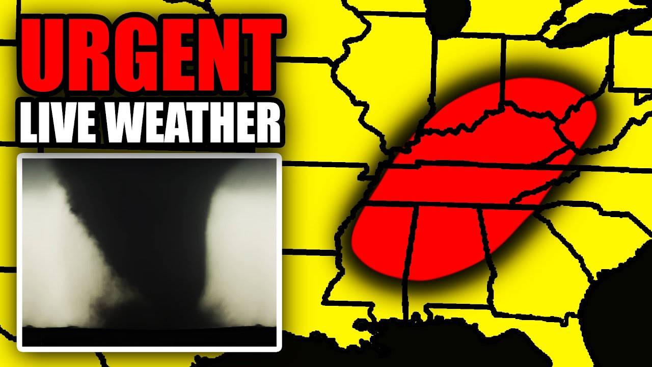
  • Three suspected tornadoes were reported in northern Oklahoma, while over a foot of snow is expected to hit Wisconsin.
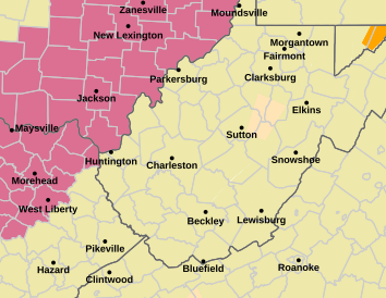
  • Meanwhile, in West Virginia, about 140,000 customers remained without electricity Tuesday afternoon — roughly 14% of the state tracked by poweroutage.us.
Thousands of homes and businesses were without power Tuesday as severe weather roared through several states, causing at least one death and spawning possible tornadoes.

In West Virginia, about 140,000 customers were without electricity Tuesday afternoon, or about 14% of all customers tracked in the state by poweroutage.us. Meanwhile, a spring snowstorm was expected to drop more than a foot of snow in Wisconsin.

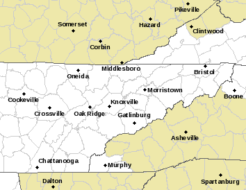
One of the hardest-hit areas was northeastern Oklahoma, where a strong weather system containing heavy rains produced three suspected tornadoes. The storms were also blamed for the death of a 46-year-old homeless woman in Tulsa who died inside a drainage pipe, police said.

Tulsa Fire Department spokesperson Andy Little said the woman’s boyfriend told authorities the two had gone to sleep at the entrance of the drainage pipe and were awakened by the flood waters. National Weather Service meteorologist Robert Darby said up to 1.5 inches of rain fell in Tulsa in about one hour before moving northeastward out of the state.

"It wasn’t a whole lot. But when it came down it was pretty rapid," Darby said.

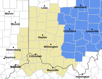
In Ohio, firefighters came to the rescue of two people who were trapped under a bridge early Tuesday when the waters of an Ohio river began rising, and forecasters warned more severe weather was headed to the area.

The two people were sleeping under the bridge around 8:45 a.m. when the Scioto River started to rise, the Columbus Fire Department reported. While the pair were never directly in the water, the flooding prevented them from returning to the shore, so a fire department boat was sent to rescue them.

No injuries were reported.
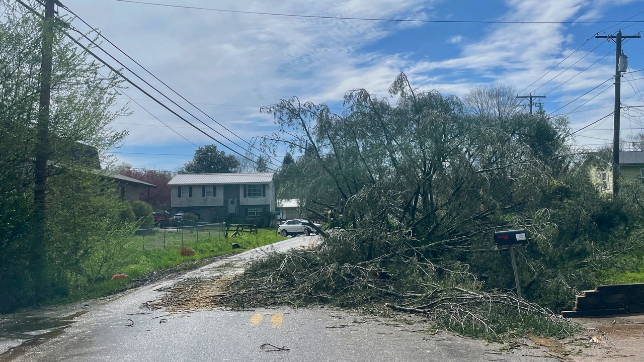
In southern Ohio, Mindy Broughton, 49, rushed into her mobile home Tuesday morning as the hail began pouring down and the winds picked up at the RV Park where she has lived near Hanging Rock for two years.

Broughton and her fiancé hunkered down as the mobile home quickly began rocking. Broughton said her fiancé used his body to shield her as the winds raged outside.

"I said I think we may die today," she said.

In a matter of seconds, the winds died down. When Broughton opened her mobile home door, she saw the devastation left behind. The RV Park was littered with debris and overturned RVs. Luckily, Broughton said there was no one inside the overturned mobile homes that could be seen in her Facebook Live video.

One neighbor told Broughton that he had seen a funnel cloud. The National Weather Service of Charleston, West Virginia, had issued a tornado warning for the Mid-Ohio valley Tuesday morning.

After Tuesday’s storm, Broughton headed to a nearby American Legion building. She said she’s not sticking around in case the weather worsens.

More:


Groucho

Has No Life - Lives on TB
It looks like it totally missed us. We had some winds around 30mph and some rain. I'm thankful and pray for those South of us who look like they got hit.
 

jward

passin' thru
Crime With Bobby
@crimewithbobby
BREAKING | Tornado touchdown in Conyers Georgia

Reports of trees down, trees on homes, injuries and people trapped

Many roads are blocked, first responders not able to reach all calls
 

zeker

Has No Life - Lives on TB
northern ontario..

started getting a bit breezy yesterday afternoon.

winds began to increase slowly for several hrs

by 9pm winds were really howling.

heard the trees cracking after supper.

9.30 power out

12.30 winds die down very fast and heavy rain began

power back at 2.30am and still raining, albeit, just a heavy drizzle.
 
Top