We had relief from the smoke all day yesterday and this morning. The new guys are taking over the Table Mt Complex.
Here is the update from today. We are now at 10% containment. It's progress, we'll take it!
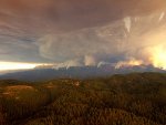
Table Mountain Fire News Release - 9/23/2012
Incident: Table Mountain Fire Wildfire
Released: 1:22 hrs. ago
Related Information
PDF Version of Update (PDF 131 kb)
Table Mountain Fire Information Update
Contact: Public Information Office - 206-947-9705 or 206-947-9737
Sunday, September 23, 2012 - 11:00 am PDT Fire Status Update
Size: 30,484 acres·
Containment: 10%
Personnel: 1,050
News & Events for the Table Mountain Fire:
· Pacific Northwest Team 2 (Incident Commander Mike Morcom) has assumed management of the Table Mountain Fire. The efforts made by Washington Incident Management Team 2 (IC Rex Reed), the Washington State Fire Marshall, Kittitas County Fire Department, Kittitas and Yakima County Sheriffs, the National Guard and the federal land management agency resources is greatly appreciated.
· It has been confirmed that two cabins destroyed by the Table Mountain Fire include the Table Mountain A-frame rental cabin and the Riders Cabin, both US Forest Service-administered properties.
· Evacuation levels, area and road closures remain in place for public safety purposes (detailed information below); approximately 800 structures remain threatened. The Table Mountain Fire has new social media sites; see below for more information.
· The Incident Command Post, currently located in Teanaway, will move to the Rotary Park sports complex in Ellensburg (tentatively scheduled for Tuesday, September 24, 2012).
· Fire activity is expected to increase slightly today from yesterday with interior burning occurring within the fire perimeter and potential for intense flare-ups and rapid rates of spread in some areas if wind and topography are aligned.
· Today/tonight is the last shift for Washington State structure protection resources; however, other assigned resources will remain on night shift for patrolling and initial attack response as needed.
Table Mountain Fire Operations Summary:
Last night, fire crews made good progress with structure protection and mop up efforts in Reecer. Crews also continued efforts to strengthen and tie in portions of the fire line along the W/S flanks down to US Hwy 97 with some smaller burnout operations conducted on the N flank. Historic mining structures were protected on the S flank near Reecer and sprinklers were installed at Green Cabin. Hotshot crews made progress tying in hand lines with dozer lines near Wilson Creek. On the W flank, crews strengthened contingency lines.
Fire crews continue to provide initial attack response and structure protection around Liberty and Reecer in the Liberty, Liberty Mountain, Pine Gulch, Harkness and Deer Gulch areas.
For firefighter safety purposes, future burnout operations planned for the N flank of the fire will be closely coordinated with fire operations personnel assigned to the Wenatchee Complex. With the reduced fire activity, firefighters will look for opportunities to take a direct attack approach, particularly on the E flank, in an effort to minimize fire spread. The fire has been slowed by rocky terrain in the Naneum Basin area.
Closures: Local road closures remain in effect; go to the Kittitas County Emergency Operations Center, Inciweb or the Okangon-Wenatchee National Forest website for current road and area closure information.
Area Closures: As of September 22, 2012, all State lands east of the Naneum State Forest line to the Columbia River are closed due to fire hazards. This includes the Colockum, Quilomene and Whiskey Dick's Wildlife Areas. Forest closures remain in place for the Naneum State Forest and the Okanogan-Wenatchee National Forest east of Highway 97.
US Highway 97 has been closed intermittently, or restricted access, due to the fire situation. For the most updated information, visit the WADOT website at
http://www.wsdot.was.gov/
Forest Service and Department of Natural Resource Road Closures: Reecer Creek Road at the Snowpack, Wilson Creek Rd. at the end of the county road, Coleman Canyon Rd., Schnebly Canyon Rd., and Cook Canyon Rd. Additional roads include Liberty Rd., Williams Creek Rd., Harkness Rd., Pine Gulch Rd. east of Red Top Rd., Cougar Gulch Rd., Boulder Creek Rd., Upper Green Canyon Rd., Sun East Rd. at the top of Robbins Rd., and Elk Springs Rd.
Red Cross Shelter: The shelter at Mercer Creek Church remains open. The church is located at 407 North "B" Street in Ellensburg. The shelter can provide meals, toiletries, showers or other services, even for those who do not need to stay overnight.
Animal Shelter: Evacuated livestock and temporary housing for small pets available until a vet clinic can be found for providing long-term care. There is 30 livestock currently housed at the shelter for this purpose. Shelter staff are taking calls from 8:00 a.m. to 5:00 p.m. Monday-Friday at 509-962-7639. If a need arises outside of normal business hours, please call the Emergency Operations Center at 509-933-8305.
FIRE FACTS:
Table Mountain Fire: Started: September 8, 2012 Cause: lightning Location: Cle Elum, WA/Kittitas County Resources: A total of 1,050 personnel assigned to the fire, including 6 hotshot crews, 17 type II hand crews, 7 helicopters, 84 engines, 10 dozers and 20 water tenders.
SAFETY CONCERNS: Transfer of command day with a new fire management team increases the need to ensure communications and work assignments to the firefighters are clear and understood.
RESOURCE CONCERNS: Multiple historic cabins, archaeological sites, mines, threatened and endangered species, old growth reserves.
WEATHER: No Red Flag warning today. Skies partly cloudy with areas of valley smoke in the morning and patchy smoke in the afternoon. Max temps 76 degrees at lower elevations and 66 degrees at higher elevations. Relative humidities 28-38%, down 5-7% from yesterday. Downslope winds 3-6 mph becoming upslope 4-8 mph with gusts to 14 mph after 11:00 a.m. Ridgetop winds NE to E 7-10 mph with gusts to 18 mph.
WEATHER OUTLOOK: Partly cloudy tonight with areas of smoke. Good humidity recoveries o the mid slopes and ridges. Temps 50-58 degrees at the ridge tops and 43-50 in canyon bottoms. Relative humidity max 50 to 70% midslope to ridgetop and 70 to 90% in canyon bottoms. Downslope winds 4 to 8 mph and strong NW winds with gusts to 30 mph likely in the Kittitas Valley into Monday morning.
TODAY'S EXPECTED FIRE BEHAVIOR: On the NW flank of the fires, fire behavior is expected to be similar to yesterday with predicted S and E winds. There is potential for flare-up and interior burning, although the fire is in rocky areas that will limit spread. On the W flank, S winds may increase fire behavior in the Green Canyon area. On the SW flank, the fire will continue to back downslope and against the wind, particularly in Wilson Canyon. On the E flank, there is a potential for very rapid spread and intense flare-ups where fuels, wind and slopes align.
COOPERATING AGENCIES & PARTNERS: Washington Department of Natural Resources, Washington Department of Fish and Wildlife, Washington State Fire Marshall, Kittitas County Fire Districts #1, #2, #7, Kittitas County Sheriff, Yakima County Sheriff, National Guard Resources, British Columbia Wildfire and the Okanagon-Wenatchee National Forest.
·Next scheduled infrared flight will provide acreage update
http://www.inciweb.org/incident/article/3269/17756/