DISASTER Serious Wildfires Spreading Fast, eastern Washington + Oregon

Cascadians

Leska Emerald Adams
Extreme danger, health hazard, immediate evacuations, not contained at all, no significant rain any time in the near future.

[ Fair Use: For Educational / Research / Discussion Purposes Only ]
http://usnews.nbcnews.com/_news/201...-new-evacuations-in-washington-wildfires?lite
September 20, 2012, By Miguel Llanos, NBC News

Chunks of flying, burning bark cause new evacuations in Washington wildfires

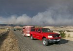
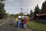
Crews on Thursday were battling a fire that forced dozens of eastern Washington residents to flee overnight with their valuables -- and some even with livestock in trailers. The evacuations add to the hundreds of people who earlier evacuated across the region due to fires raging over the last few weeks.

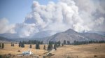
The new evacuations, this time in the Mission Ridge area near Wenatchee, came as eight-inch chunks of burning bark were reported to have fallen in Mission Ridge. Those chunks were coming from an explosive fire inside the Table Mountain Complex some six miles away, a fire incident spokesman said.
"There are indicators of extreme fire behavior and residents of these areas are strongly advised to leave the closure area as soon as possible
," the incident team said in a statement.

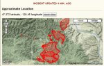
The Table Mountain Fire Complex is actually four fires that have so far burned 9,500 acres within the Wenatchee National Forest. The fires, and dozens of others in eastern Washington, were started by lightning earlier this month.
A second Table Mountain fire on Wednesday caused the closure of Highway 97 for much of the day.

The complex of fires was just 4 percent contained on Thursday morning.
In Liberty, a town of several dozen that's just two miles from one of the Table Mountain fires, some residents were preparing to leave if an evacuation order is issued.

"This time we're watching it pretty close, real close," Larry Smith told NBC affiliate KING5.com as he and his wife packed up.

But Paul Heit told KING5.com that he wasn't packing just yet.
"If I see flames coming over the hill and it's coming 80 miles per hour," he said, "yeah, I'll probably leave."

Some 5,000 firefighters are battling the eastern Washington fires, the largest of which is the Wenatchee Complex at nearly 40,000 acres. Nearly 2,000 firefighters have been deployed there but that complex of fires is just 12 percent contained.

The fires have created bad air quality for residents, especially in Cashmere, where the school district suspended classes for the week as a result.
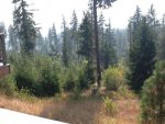
Heavy dust has also covered parts of the region. Some locals have even said the conditions are worse than when the Mount St. Helens volcano blew in 1980, sending ash across the state.
 

Flippper

Time Traveler
But you can't burn a newspaper in a trash burner because it makes pollution.

We saw quite a bit of smoke here last night but winds must have taken them away-Wenatchee is over 100 miles west of here. So far, we've been fortunate, no major fires to speak of, and this time of year firefighters are spread out pretty thin, the last out are the dregs pulled from janitorial, desk or maintenance jobs. We haven't had rain for a long time now, our rainy season begins around mid October.
 

Issy

Veteran Member
I read this morning in one of the local papers online (can't remember which now), that these fires cover 88 square miles! Everything that didn't burn in the Taylor Bridge fire is burning now. The freak lightening storm on Sept 8th did strike into the "black" from that fire too. The Taylor Bridge fire was a monster in it's behavior. These fires are monsters in sheer volume!

Issy in Cle Elum
 

almost ready

Inactive
ugh - another day in the smoke. cough cough gag -- the weather people call it "haze". Sounds nicer, I guess but doesn't smell any better.

Haven't had any measurable rain since June, and none in sight.
 

Cascadians

Leska Emerald Adams
As old-timers know, I'm an aspie and one of my special interests is the weather here, and how the Death Lines have killed the moisture. Been watching closely since 1998, documenting, photos and real time satellite pix, and going out in the wilderness and seeing for myself how tinder dry it's been progressively getting.

The Death Lines are more persistent than ever, no signs they'll let up at all, no matter how many fires are raging.

I tried to warn a group of Newf owners planning a get-together, starting 15 months ago, that east of the Cascades in July - Aug - Sept - Oct would not be wise due to extreme dryness and heat and dust and fire danger, but nope, of course nobody listened, and now they are pissed that the warning turned out obviously true and accurate, and they're had to cancel but are planning to go to the same extremely dangerous place next year ... cannot fix DGIs even with gentle explanations and links to incident reports, fire maps, news articles etc.

All I can say is that being burned alive is not a fun way to exit the planet. But even that statement would be scoffed at. *sigh*

Those who desire to burn to death, go ahead, maybe the experience will teach you something, or maybe not.
 

Cascadians

Leska Emerald Adams
http://www.kirotv.com/weblogs/rebec...og/2012/sep/19/raging-fire-next-door-seattle/

2012_WILDFIRE_EAT.jpg


" .... Huge wildfires are burning a mere 75 miles from Seattle ....

Wenatchee, Ellensburg, Leavenworth and several other eastern Washington cities are socked in with smoke from raging wildfires in the lee of the Cascades. Air quality has been ranked as hazardous in Wenatchee for the last 7 days.

After a month of dry, hot weather the fires were sparked by lightning September 9th . Lightning strikes caused about 100 individual fires and strong wind led to the rapidly expanding burn zones to be labeled the Wenatchee Complex. The complex includes over 50 lightning caused fires in Chelan county. These fires have been growing and consuming for the last 10 days.

The tally of burned and demolished homes, farms and wild land continues today. Fire is a way of nature regenerating itself but we have so many of our firefighters trying to contain it that the concern has become much larger, not to mention the health hazard the smoke has created for residents and firefighters. .... "
 
Thanks Leska,

It's looking rather grim for the Idaho panhandle and NW Montana too. The conditions are setting up to be even dryer with consistent heat. The woods have an abundance of fuels from both undergrowth and disease stricken and beetle infested trees. Looking for a moisture trend soon or we may be in trouble.

===

.
 

Cascadians

Leska Emerald Adams
Yes, Orka and I are safe. Although the western side of the Cascades is also totally dry and parched and until today was very hot. We also are in extreme fire danger.

Looking at real-time satellite, no rain for a long time to come.

I'm literally in the rivers here every day and the water level is very low. Lowest I've ever seen.

Praying for all the good ppl in eastern flanks and also Idaho and Montana etc. Let others be fire aware even though it seems most ppl react violently if you gently mention there's something worth keeping a watch out for. The ostriches are more stubbornly virulent than ever.
 

Cascadians

Leska Emerald Adams
Last year we went to the east side to scope out the Barlow Trail for mushing. I was shocked at how dry and dusty everything was, like Mars, with tall dead trees leaning everywhere. The place was like an advertisement for RUN: FIRE!!!

My eyeballs about fell out when I saw multiple campfires going and random bonfires in the midst of this. Campgrounds there were full so ppl were improvising their own sites. Big fires throwing sparks all over the place.

We hightailed it out of there and I knew the western flanks were doomed. Really does not take a rocket scientist, just a look in the ground at how many feet the holes go of utter dryness where dead trees fell over.

Burning to a crisp and choking on smoke is not a fun way to exit the planet.
 

cuz1961

Membership Revoked
issy is having internet issues...

so here are the pic issy sent me

stay safe sis,,,,
 

Attachments

  • photo-6.jpg
    photo-6.jpg
    51.8 KB · Views: 222
  • photo-3.JPG
    photo-3.JPG
    44.4 KB · Views: 220
  • photo-4.JPG
    photo-4.JPG
    54.6 KB · Views: 222
  • photo-5.JPG
    photo-5.JPG
    36.5 KB · Views: 221

Flippper

Time Traveler
I've fought wildfires, and one faller, an older wise feller said "You know, we're here fighting this thing, but in truth, there's not a damn thing we can do to put it out. It'll go out when it's good and ready, and not one moment before. If you think otherwise, you're fooling yourself." And he was quite correct, I knew it but didn't want to say it and dishearten the other firefighters. Small fires of only a few acres are one thing, you can douse them with retardant or bubbles, but larger ones create their own weather and winds, not much you can do about that but pray.
 

maric

Short but deadly
Spokane has been smokey for days but I think today it was just a tad better ~cough~ Maybe.
 

Cascadians

Leska Emerald Adams
[ Fair Use: For Educational / Research / Discussion Purposes Only ]
http://news.lalate.com/2012/09/20/wenatchee-fire-map-2012-prompts-new-washington-wildfire-concerns/
September 20th, 2012 in Fires by LALATE

Wenatchee Fire Map 2012 Prompts New Washington Wildfire Concerns

ST LOUIS (LALATE) – A growth in the Wenatchee River Complex Fire map 2012 tonight and the Table Mountain Complex Fire have prompted new Washington wildfire concerns Thursday. Officials tell news that the Wenatchee Fire and the Table Mountain Fire are both advancing prompting new evacuations tonight.

In a news briefing this evening September 20, 2012, officials indicated that six hundred newly threatened residence were evacuated. These join the they already one hundred sixty homes recently evacuated.

Officials are worried that the two fires could merge south of Wenatchee, reports the Seattle Times. The Table Mountain Complex Fire is at only four percent containment having already taken more than thirty thousand acres. The Wenatchee River fire, in contrast, has taken nearly forty thousand acres and remains only twenty-two percent contained.

Incident Commander Jeff Pendleton tells news that the two fires are being advanced by timber, brush and grass. Nearly two thousand fire fighters are on scene.

The Wenatchee Complex Fire includes the Canyon, Poison Canyon, Byrd, Pevine Canyon, First Creek, Pyramid, Klone, Cashmere, and Basalt fires. “Priority response has been given to those areas which posed the greatest threat to life and communities” officials tell news tonight. For the latest fire map, click HERE.
http://www.inciweb.org/incident/3258/
 

Cascadians

Leska Emerald Adams
Thank you Heliobas, exactly what needs to be posted so ppl can see the extent of this and how fast it is spreading.
 

Old Futz

Inactive
For those of us in the area, keep a close eye on the Saturday weather scenario. Currently a 20% chance of dry lightning in both sides of the Cascades into Saturday evening, and expect the current fire weather warning to be boosted to a Red Flag warning if this develops. No manpower reserves left in our valley. You might think of taking out your maps, compass and binoculars, doing some volunteer patrolling and lookout work, and report any fire starts you see before they have a chance to grow. Carry shovel, axe/pulaski, and water if you travel. Even smoking now is forbidden.
 

Cascadians

Leska Emerald Adams
Looking at that map, you can see the fires will form a long barrier to roads. Folks, get out your maps and chart your escape routes now, with a few alternatives figured out in advance.

Praying for all. There is no real rain in the forecast but there is dry lightning coming up. Thanks for the tips Old Futz.
 

Great Northwet

Veteran Member
I started the thread about the Taylor Bridge fire a few weeks ago(to tired to link it now), and will be going over on saturday to look at impacts on wildlife and infrastucture in the area.

I'm pretty sure that the Colockum Pass area is closed by now, and back west through Lion Rock to Liberty. SR 97 also may be closed through Blewitt Pas(not sure though).

Thanks for the tips and maps everyone.
 

Issy

Veteran Member
larger than the city of Seattle.

http://www.yakima-herald.com/storie...ildfires-continue-to-grow-160-homes-evacuated

Alarming trend: State wildfires continue to grow; 160 homes evacuated
By Brian M. Rosenthal 
and CRAIG WELCH
The Seattle Times

WENATCHEE – Among the pine-draped hills southwest of Wenatchee on Thursday the state’s two biggest wildfires threatened to merge into an inferno larger than the city of Seattle.

Fire officials spent the day warily eying the spreading flames east of Highway 97 near Blewett Pass, not sure whether a merger might prove a welcome step toward finally wrestling these blazes under control — or lead to a far more volatile conflagration.

But after firefighters scrambled to protect more than 600 at-risk homes in Chelan and Kittitas counties, it was becoming clearer by early evening that the merger was coming whether fire officials wanted it or not.

"It’s just one of those things that’s probably going to happen," said fire spokeswoman Connie Mehmel. "It’s really to the point where we need to back off a bit. We don’t want to be in the middle of those two fires that are trying to come together."

The Table Mountain Complex and Wenatchee Complex fires had burned across more than 70,000 acres by early evening in what officials called the largest fire event in years.

As of Thursday night, no civilian lives or homes had been lost, but a firefighter in the Wenatchee Complex died at the hostpital this week. Hundreds have been evacuated and smoky air continues to flood the entire region, raising public health concerns and grounding aircraft, complicating life and the firefighting effort.

"The smoke seems to be getting thicker and thicker," said another fire spokesman, Alan Hoffmeister.

The rapidly spreading flames raged a full month after the typical peak of fire season, in a year that has seen the fewest fires nationwide in the past decade. But those fires have devastated nearly 8.5 million acres, more than in all but one of the past 10 years.

"Typically, our fire danger indices spike on Aug. 19," said Jason Loomis, a fire analyst with the Northwest Interagency Coordination Center in Portland. "But we didn’t see that this year. We’ve just had this relentless, persistent pattern of hot, dry weather."

Rex Reed, incident commander on the Wenatchee Complex fires, said a fire this big in September is unprecedented in his career, which began in 1974. And while the behavior of the flames hasn’t been extreme, they have been relentless.

"Typically our fires’ burn period is six to seven hours a day, and then it moderates for the remaining 17 or 18 hours," Loomis said. "The last few days it’s been gaining ground 24 hours a day, not even settling down at night."

Meanwhile, the smoke-filled valleys make seeing new blazes difficult, so by the time firefighters arrive to put out spot fires, the blazes have grown substantially.

The blazes started on Sept. 8, when a huge lightning storm ignited 110 fires.

While smaller fires continue to burn from the Methow Valley to Mount Adams, the Chelan and Kittitas blazes came together into two main groups. The Wenatchee Complex neared 42,000 acres Thursday evening and was 24 percent contained, while the Table Mountain Complex topped 30,000 acres.

Both exploded overnight Wednesday, and by Thursday it had become clear they were headed toward one another.

"When they start to get close, they can start sucking each other in, building the intensity up," said John Segar, fire-management branch chief for the U.S. Fish and Wildlife Service in Boise, Idaho.

In the worst case, merging fires can feed off each other’s energy and burn hotter and send flames shooting higher into the trees where they spit out more embers and create more spot fires, causing the new larger blaze to gobble up ground even faster.

Alternatively, the two approaching fires may consume all available fuel and help snuff each other out while weary firefighters get to focus on scratching out a single fire break instead of two.

"From a strategic standpoint, it will make things easier and more predictable," said Mehmel.

The Table Mountain Complex was the more concerning during part of the day Thursday, as it appeared to lurch toward hundreds of homes including those in the small Kittitas County community of Liberty.

But the latest evacuations were farther north, where residents near the Mission Ridge ski area were urged to leave Wednesday night after reports of "raining burning ashes," said Hoffmeister.

One of those evacuees, 45-year-old homemaker Michelle Shermer, said she and her five children had been preparing for the possibility of leaving for a week.

When the call came, Shermer said, they grabbed some keepsakes — including an old dollhouse — and left.

In 13 years of living up on Forrest Ridge, the family had never before had to evacuate, Shermer said.

"We knew it would happen someday," said Shermer, sitting in a Wenatchee Wendy’s parking lot and wearing a mask to protect herself from the ashy air. "You live with it up here. I’m glad we were prepared."

Many residents were wearing similar masks Thursday, including 7-year-old Emily Jimenez.

Emily couldn’t help playing with the mask as she left Lewis and Clark Elementary School at around 3 p.m.

Her uncle, Moses Verduzco, said the girl would be wearing a mask for the next two weeks.

"You better believe it," the 22-year-old said. "Better than getting all kinds of diseases from the smoke."
 

Issy

Veteran Member
Table Mountain fire triples in size

http://www.king5.com/news/local/Table-Mountain-fire-in-Wash-triples-in-size-170587306.html

The Table Mountain Complex of wildfires in central Washington's Chelan and Kittitas counties has tripled in size to more than 47 square miles, fire spokeswoman Jan Ulrich said Thursday.

A combination of factors -- including warm temperatures, winds, very low humidity and low moisture in the vegetation -- caused the complex to grow and merge into one large fire on Wednesday, Ulrich said.

"It was very active fire behavior yesterday and we are expecting the same today,"' Ulrich said Thursday.

Emergency operations officials said they are watching the fire's massive smoke plume closely. The smoke column reached 40,000 feet on Wednesday and was expected to do the same on Thursday. The fear is that cooler air in the upper atmosphere would cause the column to collapose on itself, spreading hot gas and embers along the fire's base in every direction.

Learn how a smoke column can create its own lightning.

The Table Mountain blaze is being fought by 655 firefighters and is 4 percent contained. Crews from as far away as Arizona and Louisiana are helping fight the fire.

It has not burned any homes, but Kittitas County Sheriff Gene Dana said Thursday that 161 homes north of Ellensburg and in the Liberty area are under a Level 3 evacuation, meaning residents are urged to leave.

The Table Mountain Complex is one of several wildfires burning on the eastern slopes of the Cascade Range. The largest, the Wenatchee River Complex, has grown to about 61 square miles. It is 22 percent contained and is being fought by nearly 2,000 firefighters.
 

Issy

Veteran Member
OOps, part 2 of the above article

The fires are blanketing Eastern Washington with smoke, and dry conditions have led the state to issue restrictions on logging and other industrial activities in the forests.

The Table Mountain and Wenatchee River complexes are moving closer together, fire officials have said.

Thousands of firefighters are battling dozens of wildfires that were sparked up lightning earlier this month up and down the east slopes of the Cascades. Many of the blazes are small and in remote areas, but all together the fires have covered more than 108 square miles.

Hundreds of people have been evacuated from their homes in the paths of the fires.

Smoke from the fires is pouring across Eastern Washington, obscuring the air 200 miles away in Spokane. State officials have warned of hazardous air quality in Ellensburg and Wenatchee from the thick smoke. They are advising residents to stay indoors, limit physical activity and keep doors and windows closed.

The smoke has already prompted some schools to relocate weekend sporting events. Central Washington University is moving its Saturday football game against Azusa Pacific from Ellensburg to the Seattle suburb of Bothell.

"Unfortunately, areas around Wenatchee remain in the worst shape," said Sean Hopkins, of the state Department of Ecology, in Yakima. "At the same time, other areas are experiencing unhealthy air anywhere smoke lingers from the hundreds of wildfires that are burning."

Air-quality monitors in Chelan County are reading in the hazardous and unhealthy ranges, the agency said. Conditions are getting worse in the Quincy area, and conditions could worsen around Spokane, Pullman and Clarkston.

Central Washington University moved its Saturday football game against Azusa Pacific University from Ellensburg to Bothell, in what would have been the school's home opener. A Friday night high school game between Wenatchee and Eastmont also was moved to Moses Lake.

The Red Cross has re-activated the emergency shelter in Wenatchee at the Seventh Day Adventist Church on the corner of 5th and Western.

An emergency animal shelter has been opened at the Chelan County Fairgrounds for large domestic animals. Small animals may be sheltered at the Countryside Veterinary Clinic, 405 Ohme Road.

The Washington state Department of Natural Resources on Thursday announced a shutdown of all logging and industrial operations in the woods to avoid accidental starting of fires. The shutdown covers portions of Douglas, Chelan, Kittitas, Yakima and Klickitat counties.
 

Issy

Veteran Member
I started the thread about the Taylor Bridge fire a few weeks ago(to tired to link it now), and will be going over on saturday to look at impacts on wildlife and infrastucture in the area.

I'm pretty sure that the Colockum Pass area is closed by now, and back west through Lion Rock to Liberty. SR 97 also may be closed through Blewitt Pas(not sure though).

Thanks for the tips and maps everyone.

I think Blewett Pass is still closed. Everything around Liberty is closed. They have the list of road closures on www.co.kittitas.wa.us
Since Table Mountain Complex and Wenatchee Complex are still listed seperately, you will have to click on each incident to get all the closures.

Yes, hubby has been patroling with binocs from "up high" for weeks. It's very hard to get up to date info. We just have to be in a constant state of ready. The prolonged state is taxing mentally week after week.
 

Cascadians

Leska Emerald Adams
Issy and all, thank you so much for updating this and sharing your info. Of all the disasters possible I think fire is the most horrendous. Hoping there will be time for everybody to get out when they need to. It's ssoooo dry, think it would take months of rain to even get rootballs soaking sufficiently to de-fuel the trees.
 

maric

Short but deadly
KREM.com

Posted on September 20, 2012 at 5:23 PM


SPOKANE-- Smoke from Central Washington wildfires drifted into Eastern Washington this week.

Haze over Spokane was seen Thursday. The Spokane Regional Clean Air Agency downgraded air quality condition.

Thursday the air was considered unhealthy for elderly people and anyone with breathing problems.

Wildfire smoke continued to linger in Benewah, Kootenai, Shoshone Bonner and Boundary Counties. Concentrations of fine particulate remain elevated in most areas Improvement in air quality is expected as today progresses. However, poor atmospheric mixing will persist and we could likely see pollutants build again through the weekend.

Kootenai County had moderate air quality. Unusually sensitive people were asked to reduce prolonged or heavy exertion outdoors. No open outdoor burning was allowed by state air quality rule.

Click here to download the KREM 2 WeatherCaster iPad or Stormtracker 2 smartphone app.

The Pinehurst, Silver Valley air quality was named unhealthy for sensitive groups. People with heart or lung disease, older adults, and children were asked to reduce prolonged or heavy exertion outdoors. No open outdoor burning was allowed by state air quality rule.

The Greater Sandpoint area had moderate air quality. Unusually sensitive people were asked to reduce prolonged or heavy exertion outdoors. No open outdoor burning was allowed by state air quality rule.

The Bonners Ferry area had good air quality.

St. Maries’ air quality was named unhealthy for sensitive groups. People with heart or lung disease, older adults, and children were asked to reduce prolonged or heavy exertion outdoors. No open outdoor burning was allowed by state air quality rule.


http://www.krem.com/news/Wildfires-...-in-N-Idaho-Eastern-Washington-170597346.html
 

cuz1961

Membership Revoked
im pretty sure death lines is a reference to chem trails,,

aluminum used in weather modification geo engineering
to rob moisture from one area and bring it to another,
bring drought. fine aluminum , very flammable , coating
EVERYTHING. (maybe why monsato has alum resistant gmo seed)

ive noticed on the tv coverage of the fires here in nor cal
that the flames are of an intensity and color i have never
seen on 39 of the forest fires ive been working at.

do i think there is a positive connection ?

kinda, but that doesn't mean im right.
 

Flippper

Time Traveler
Her uncle, Moses Verduzco, said the girl would be wearing a mask for the next two weeks.

"You better believe it," the 22-year-old said. "Better than getting all kinds of diseases from the smoke."

WTF has he been smoking?
 

almost ready

Inactive
If she's 22 she's been thoroughly indoctrinated that inhaling even small amounts of smoke will cause all sorts of diseases, from the anti-tobacco campaigns in the schools.
 

Issy

Veteran Member
I started the thread about the Taylor Bridge fire a few weeks ago(to tired to link it now), and will be going over on saturday to look at impacts on wildlife and infrastucture in the area.

I'm pretty sure that the Colockum Pass area is closed by now, and back west through Lion Rock to Liberty. SR 97 also may be closed through Blewitt Pas(not sure though).
Thanks for the tips and maps everyone.

Here is an update on the area for you.

09/21/2012 - 1:36 pm: Effective 12pm today, all state lands are closed east of the Naneum State Forest line to the Columbia River, and north of Vantage Highway to just north of the Kittitas-Chelan County line. This includes the Colockum, Quilomene and Whiskey Dick wildlife areas.

http://www.inciweb.org/incident/3269/
 

Issy

Veteran Member
If she's 22 she's been thoroughly indoctrinated that inhaling even small amounts of smoke will cause all sorts of diseases, from the anti-tobacco campaigns in the schools.

Agreed. But some news the last few days on tv have said if you inhale the smoke, you are inhaling unseen particles that can give you pneumonia. Maybe that was his concern? I don't have a clue if that's true. And of course any excuse to sensationalize by the media is a given.
 

Issy

Veteran Member
Wow. Just heard on KEPR tv news that the fires are now 100 square miles. It is hard to grasp 100 square miles of fire.

Issy
 
Top