Snow Chaos In Serbia & The Balkans, Colder & Snowier Winter Headed For U.S. With Incoming 'Polar Vortex', + FEMA Guilty Of Twister 'Climateering' - Electroverse
Extreme Weather GSM
SNOW CHAOS IN SERBIA & THE BALKANS, COLDER & SNOWIER WINTER HEADED FOR U.S. WITH INCOMING ‘POLAR VORTEX’, + FEMA GUILTY OF TWISTER ‘CLIMATEERING’
DECEMBER 13, 2021 CAP ALLON
Dr. Vincent Gray: “The [IPCC] climate change statement is an orchestrated litany of lies.”
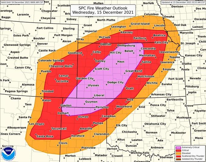
SNOW CHAOS IN SERBIA & THE BALKANS
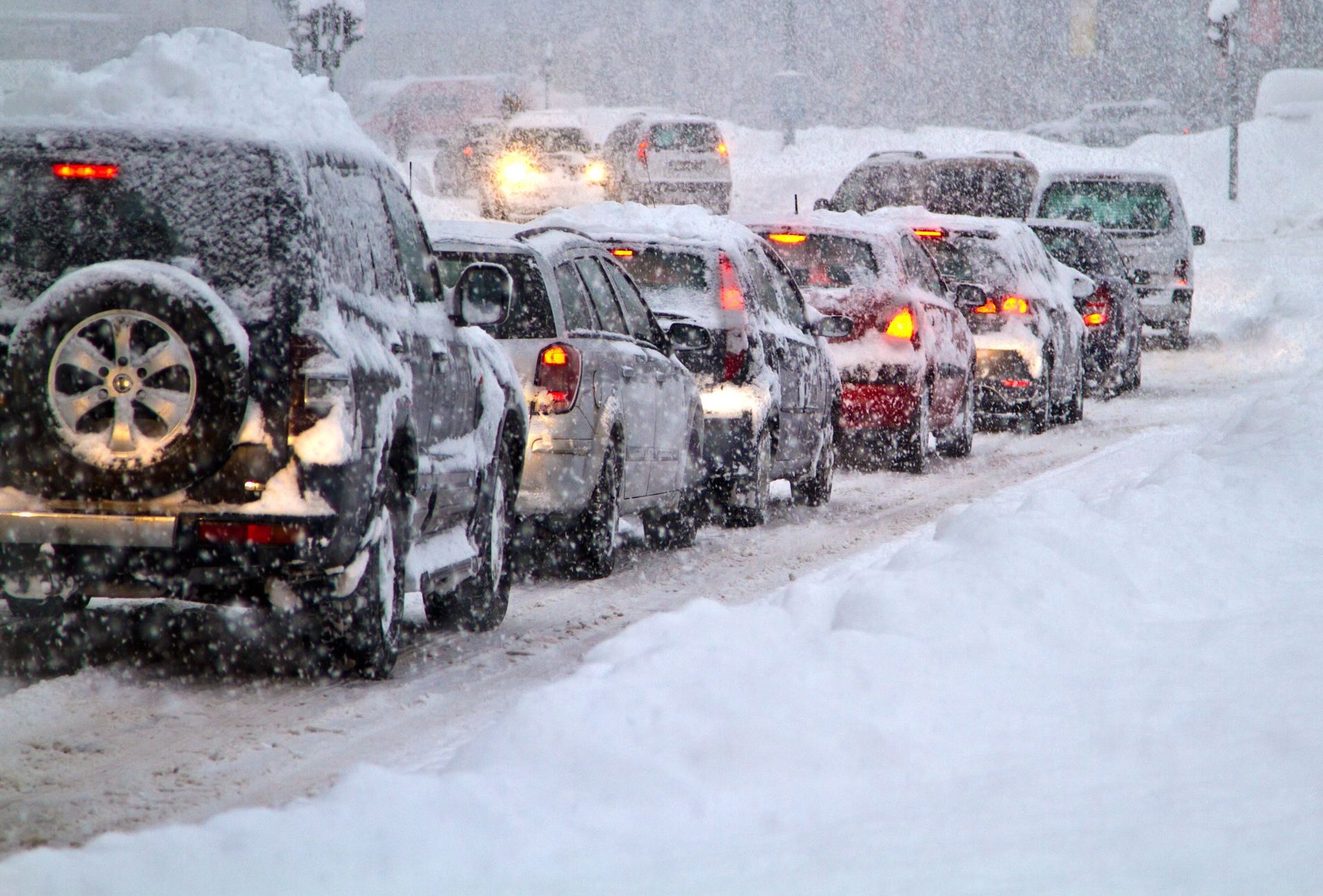
Over the weekend, heavy snow hit Serbia as well as much of the Balkans, disrupting traffic and public transport, canceling flights, and knocking out the power to tens of thousands of homes.
Much of western Serbia was without electricity on Sunday, and authorities warned against unnecessary travel and appealed to all Serbian’s to conserve power.
View: https://twitter.com/itsmesindja/status/1470007947656777729
Run time is 0:12
In the nation’s capital, Belgrade, several trees fell under the weight of the heavy snow, damaging cars and buildings — some people had to be rescued after being trapped in their vehicles.
A number of flights in and out of Belgrade’s main airport were canceled due to the snow, while a brief power cut to the main terminal also resulted in delays. A highway leading to the airport was also blocked by snow, causing further issues.
And passengers on a train to Belgrade were stuck in snow for seven hours.
Emergency services have been assisting authorities in the cleanup operation, but their efforts may be in vain as another alert for
more heavy snow and disruptive ice has been issued in and around the Balkans for this week.
View: https://twitter.com/sutija_web/status/1470173026788466689
In neighboring
Bulgaria, authorities declared a state of emergency due to intense flooding.
And likewise in
Albania, the government there has mobilized police, army and emergency forces to cope with floods following three days of continuous rain and snow.
Looking ahead, and as hinted at above, the Balkans are set for yet more snows and anomalous lows this week; while conversely, much of the European continent will enjoy a brief reprieve from the Arctic conditions that have prevailed since early-November.
But this reprieve will indeed be brief — polar cold is forecast to recommence mid-December, with the most notable temperature departures (-28C below average) gripping the east (Poland, Ukraine, Russia etc.):

GFS 2m Temp Anomalies (C) Dec 20 -Dec 29 [
tropicaltidbits.com].
COLDER & SNOWIER WINTER HEADED FOR U.S. WITH INCOMING ‘POLAR VORTEX’
Despite America’s mild Fall –which is due to low solar activity and a meridional jet stream, not man’s irrelevant CO2 emissions– southern Minnesotans saw record snow last Friday–deemed a taster of what’s to come when winter ‘proper’ hits.
Late last week, the official total at
Rochester Airport came in at
6.5 inches — this, according to National Weather Service (NWS) data, was more than an inch higher than the previous record for December 10, set back in 1970,
Reports of
9+ inches of snow were dotted throughout the city, and there were two reports of
10.5 inches to the north.
Totals at the NWS office (at the Twin Cities airport) also set a new record for Dec 10 — at
11 inches.
There were also reports of
11 inches in both
Kasson and
Owatonna.
While
12 inches hit Lake City.
Heavier accumulations were noted on the south and east edges of the Twin Cities, with
21 inches noted in
East St. Paul.
POLAR VORTEX TO SEND NATURAL GAS SOARING AGAIN
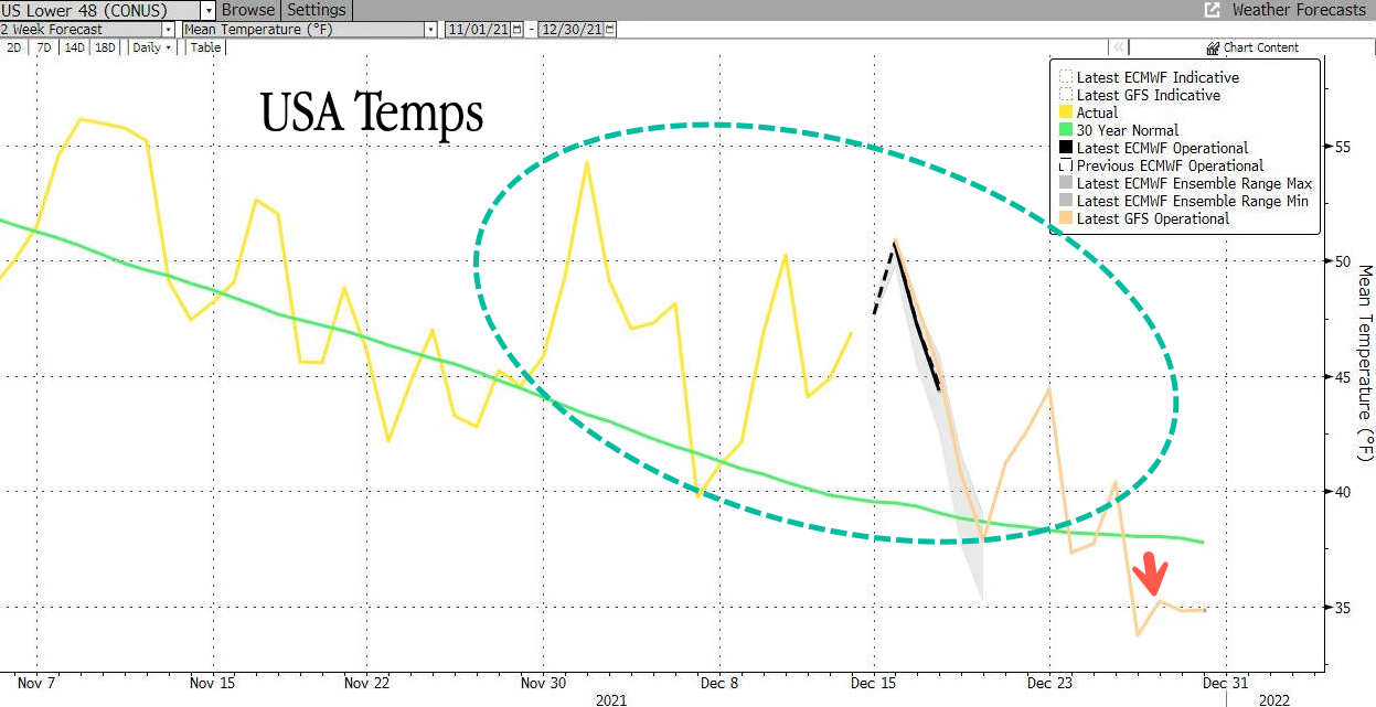
A mild fall has made many doubt that this winter will mirror last year’s of record snow and deadly freezes; however, latest weather models will check any complacency as they reveal that the U.S. should start bracing for a winter of old.
Since mid-Oct, U.S. natural gas futures have been down as the threat of colder weather and tight supplies waned, crushing bullish traders. But now, with winter less than two weeks away, comes new weather models suggesting “significantly colder” temperatures will hit later this month as the Northern Hemisphere enters its
second La Nina winter, and markets are set to rally.
Meteorologists at private weather forecasting firm
BAMWX foresee a bullish setup for natural gas futures.
They say the narrative is flipping from warmer weather to the complete opposite as a “polar vortex” (aka Arctic outbreak) threatens to plunge much of the U.S. into a far colder pattern by the New Year.
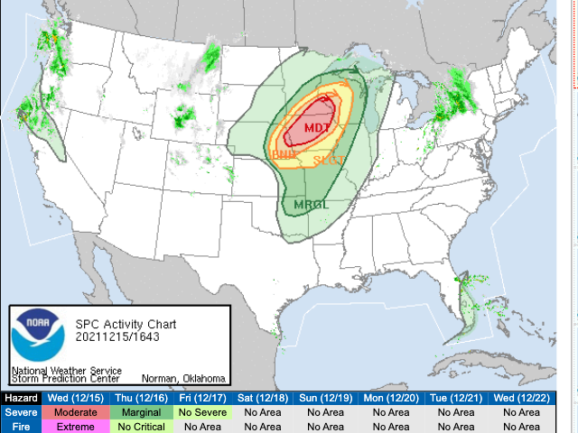
Kirk Hinz, chief meteorologist at BAMWX, said: “Seeing an interesting pattern developing ahead leading up to Christmas and into Jan ’22, as higher pressure looks to finally re-establish towards Alaska and the North Atlantic, pushing cold from the Arctic down into the US.” Atmospheric phenomenons are currently conspiring “to increase the potential for a Polar Vortex displacement event, sending more consistent cold air deeper into the US … a big risk to watch for the energy markets ahead,” added Hinz, who provided the below graphics on Twitter early Monday morning:
View: https://twitter.com/Met_khinz/status/1470225423942488064
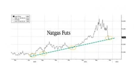
Natural gas traders are being urged to carefully monitor temperature forecasts and heating degree day estimates for the U.S. to gauge future energy demand. Futures found support on an upward sloping diagonal trend line in recent trading, with Bloomberg reporting earlier this week that traders were “buying the dip” on the prospects of colder weather later this month:
Looking across the Atlantic, colder weather and tight supplies sent Dutch natural gas for next month, the European benchmark, over the 100 euro mark and very close to the all-time highs witnessed early November:

If BAMWX calls for a ‘Polar Vortex’ play out, a monster reversal in U.S. natural gas futures will occur. And while this will be seen as good news for bullish traders, it will be bad news for consumers as bills soar and possible shortages ensue.

Latest BAMWX forecasts for ‘Polar Vortex’.
FEMA GUILTY OF TWISTER ‘CLIMATEERING’
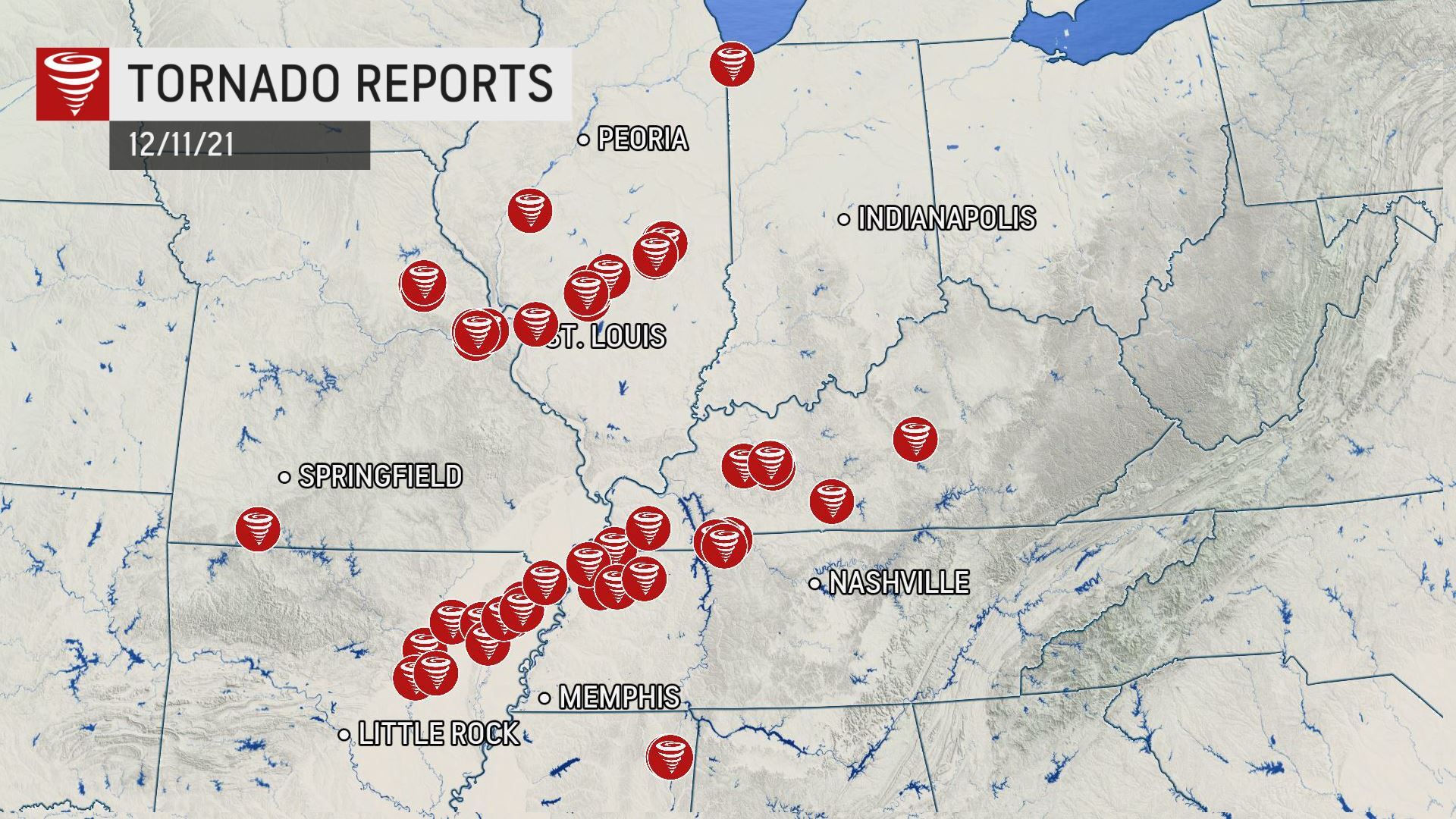
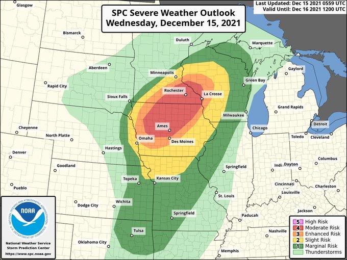
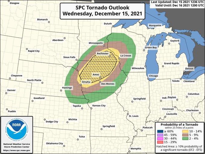
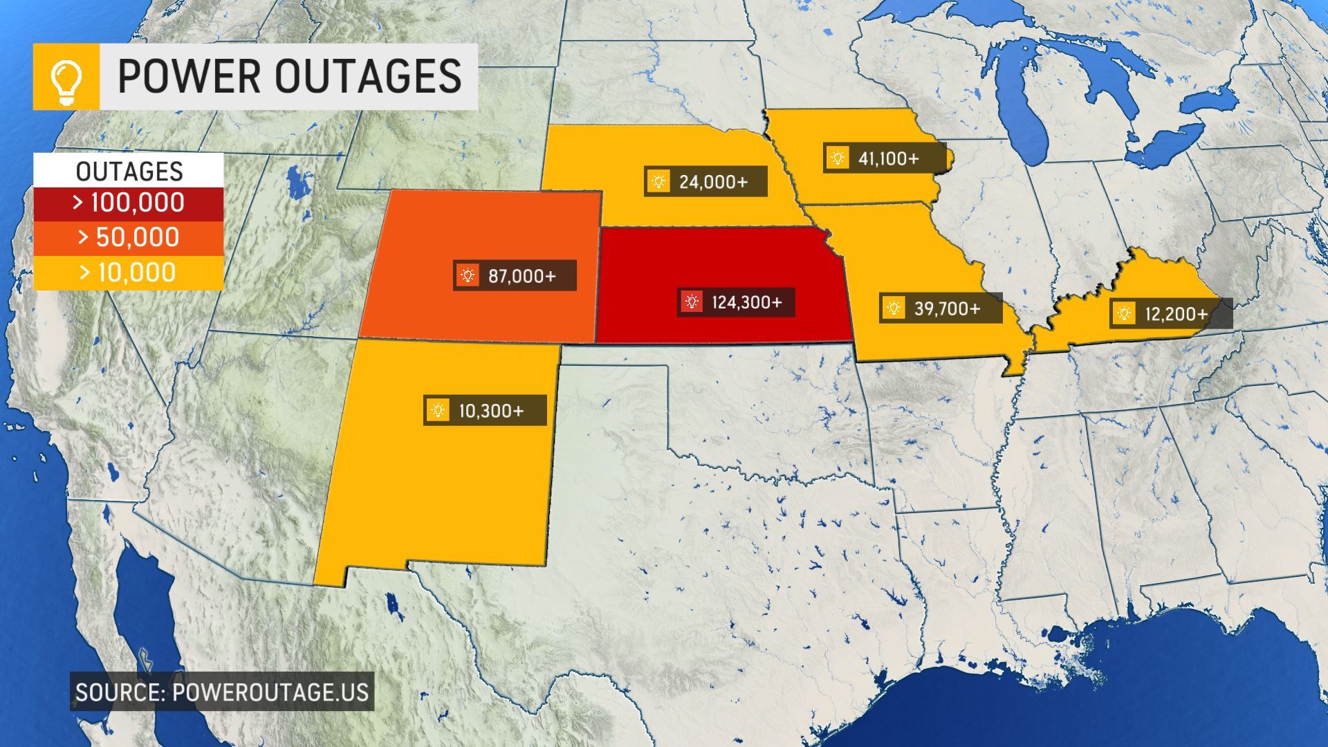
Following the weekend’s deadly U.S. tornadoes, Federal Emergency Management Agency (FEMA) Administrator Deanne Criswell could’t miss out on an opportunity to play the AGW card, saying that extreme weather events like the storms and twisters that swept through a number of states this weekend “is going to be our new normal”.
“This is going to be our new normal and the effects that we’re seeing from climate change are the crisis of our generation,” Criswell told co-host Jake Tapper on CNN’s “State of the Union”–so credibility instantly lost then.
Severe storms and tornadoes tore through states in the South and Midwest late Friday into Saturday, leaving devastating damage, tens of thousands of homes without power and almost 100 people dead.
View: https://twitter.com/mitchell_knight/status/1469656473068265479
Run time is 0:35
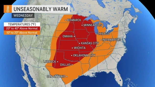
This was a tragedy, undoubtedly — a truly hellish ordeal for those there; but to blame global warming and to climateer during such a disaster is disgusting, even by CNN standards.
These days, ‘progressives’ don’t hesitate to blame any kind of severe weather on AGW.
This is even though
The Science that said alarmists repeatedly insist we follow states that
tornadoes require unusually cool air to form. As climatologist and former NASA scientist Dr. Roy Spencer explains: Very few thunderstorms produce tornadoes. In the hot and humid tropics, they are virtually unheard of. The reason why is that (unlike hurricanes) tornadoes require strong wind shear, which means wind speed increasing and changing direction with height in the lower atmosphere — conditions that exist only when a cool air mass collides with a warm air mass
–which is what occurred over the weekend:
View: https://twitter.com/extremetemps/status/1469759219599560709
The catastrophist caterwaulings of agenda-drivers like FEMA are opposed by scientific discovery and meteorological theory: This weekend’s collision of opposing air masses is actually better explained by
low solar activity:
Intense bursts of heat will linger in one area, while a teeth-chattering chill will dominate nearby -- and then the regions will "switch". GSM.

electroverse.net
Alarmists do not get to alter known reality in order to advance their warped ideologies.
History will hold them to account.
The
COLD TIMES are returning, the mid-latitudes are
REFREEZING, in line with
the great conjunction,
historically low solar activity,
cloud-nucleating Cosmic Rays, and a
meridional jet stream flow (among other forcings).
Both NOAA and NASA appear to agree,
if you read between the lines, with NOAA saying we’re entering a
‘full-blown’ Grand Solar Minimum in the late-2020s, and NASA seeing this upcoming solar cycle
(25) as “
the weakest of the past 200 years”, with the agency correlating previous solar shutdowns to prolonged periods of global cooling
here.
Furthermore, we can’t ignore the slew of new scientific papers stating the immense impact
The Beaufort Gyre could have on the Gulf Stream, and therefore the climate overall.

 Prepare accordingly
—
learn the facts, relocate if need be, and grow your own.


")