
You are using an out of date browser. It may not display this or other websites correctly.
You should upgrade or use an alternative browser.
You should upgrade or use an alternative browser.
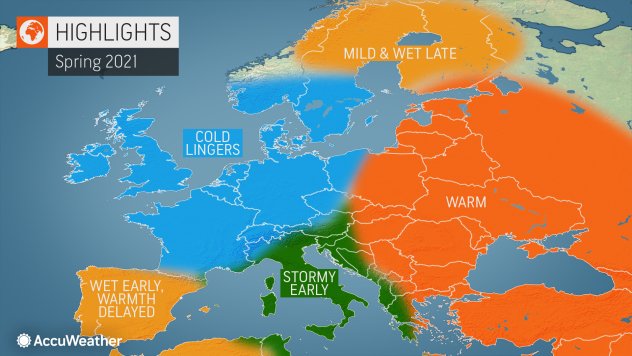
Solar Grand Solar Minimum part deux
- Thread starter Dennis Olson
- Start date
-
- Tags
- grand solar minimum
northern watch
TB Fanatic
seems like a big challenge would be knowing where to move to if one were so inclined. Central America. ie Panama?if there is going to be global cooling and a mini-ice age
very few are prepared
that will be difficult to figure. weather patterns will change.seems like a big challenge would be knowing where to move to if one were so inclined. Central America. ie Panama?
place that before, had rainfall, could end up being warm enough but turn into desert.
places that were desert could end up will too much rain.
and waiting to move until the last minute will meet with resistance from locals who will be experiencing shortages of stuff
Martinhouse
Deceased
TxGal, If you go below zero, I'm pretty sure we will here, too. Right now Sunday and Monday are showing 7 and 2 for their overnight lows. If your forecast keeps that minus 0, I'm sure we'll get at least that cold up here.
I can insulate my rabbit cages, but I fear for my chickens and my pump house. If we lose power, I'll be fearing for the household plumbing, too. Heck, I'll even be fearing for me!
Not seeing any sun to speak of until the far end of my ten-day forecast. Sun would help a lot. Hope I don't lose the things in my greenhouse. A lot of it is pretty important!
TxGal
Day by day
TxGal, If you go below zero, I'm pretty sure we will here, too. Right now Sunday and Monday are showing 7 and 2 for their overnight lows. If your forecast keeps that minus 0, I'm sure we'll get at least that cold up here.
I can insulate my rabbit cages, but I fear for my chickens and my pump house. If we lose power, I'll be fearing for the household plumbing, too. Heck, I'll even be fearing for me!
Not seeing any sun to speak of until the far end of my ten-day forecast. Sun would help a lot. Hope I don't lose the things in my greenhouse. A lot of it is pretty important!
Finally sitting down having something warm. We've been trying desperately to tie up loose ends. I'll try to pull up some Joe Bastardi tweets about this being a historic winter week ahead.
Martinhouse, the forecasters have us back to single digits Monday night into Tuesday morning, which is much better than below zero! This is going to be bad enough. I don't recall when we were above freezing last...or saw the sun! It isn't supposed to be sunny at all until the end of next week. Good grief.
Everything here is still coated in ice...and that doesn't look to be going to change at all for a good while.
TxGal
Day by day
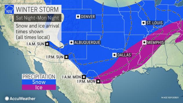
Major Winter Storms to Blanket the West and Plains in Heavy Snow and Ice - Icy Weather in the Mid-Atlantic - Ice Age Now
Major Winter Storms to Blanket the West and Plains in Heavy Snow and Ice – Icy Weather in the Mid-Atlantic
February 13, 2021 by Robert
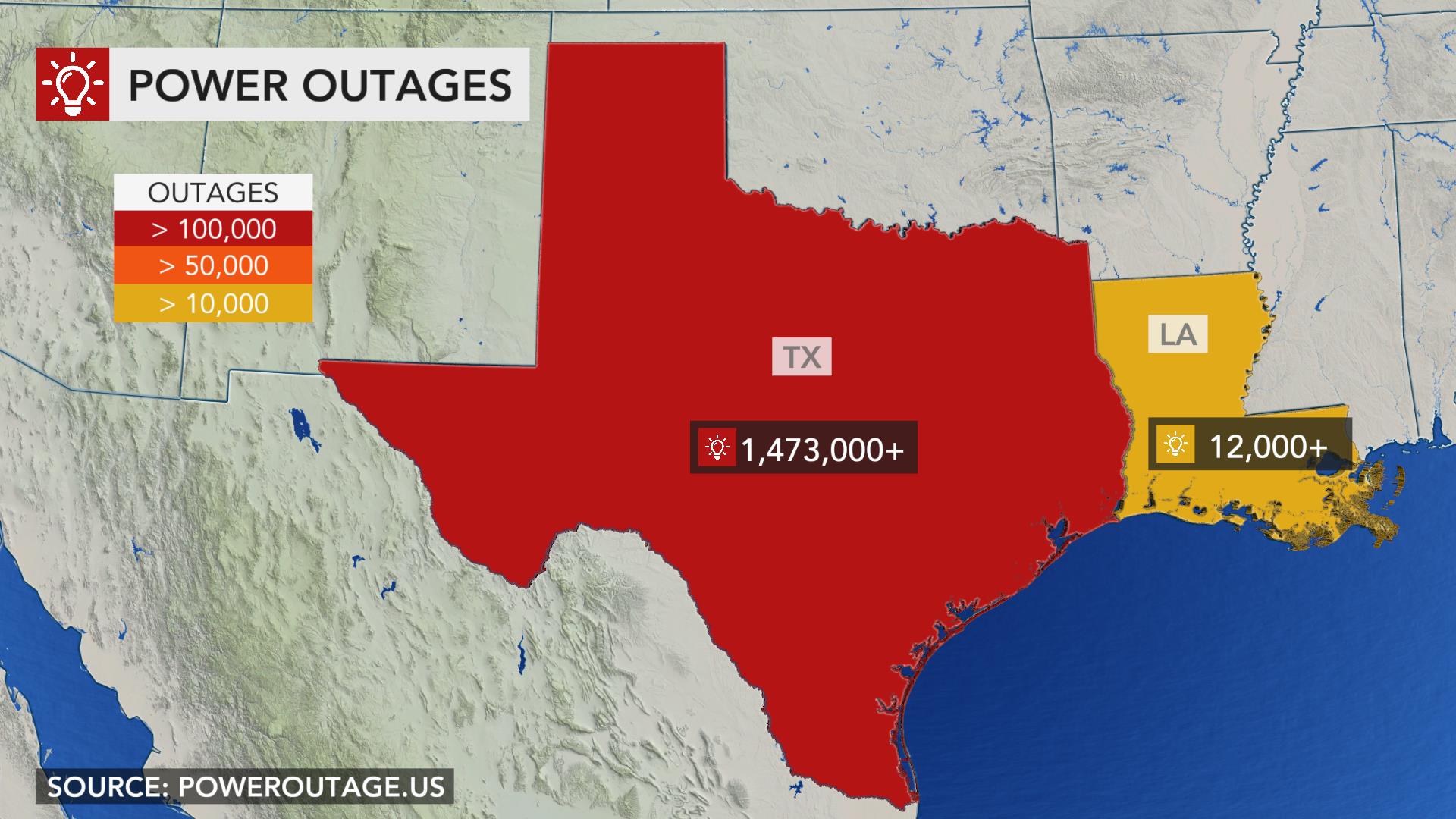
More than 100 million Americans under winter-related watches, warnings, or advisories. Brace for record cold, significant snow accumulations, icy roads, treacherous travel, blizzard conditions as far south as Dallas and beyond. Power outages.
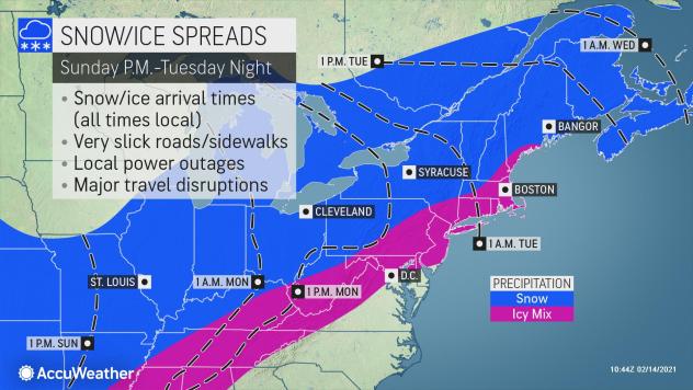
Heavy snow is falling across the mountains and lowlands of Washington and Oregon today with significant icing in northwest Oregon, according to the National Weather Service. Significant icing will also occur over Virginia and southern Maryland into Sunday. A major winter storm is expected to develop over the Southern U.S. Sunday lifting into the Northeast through Tuesday with a large area of snow, sleet, and freezing rain expected.
Starting in the East, look for showers and thunderstorms from the Carolinas to Florida. Flash Flood Watches are in effect for parts of the Florida Panhandle and both southern Georgia and Alabama this weekend where over 2″ of rainfall is expected.
Downed tree limbs and power outages expected
Farther north, Winter Weather Advisories extend from northern North Carolina to the Delaware Valley where ice accumulations as high as a quarter inch are possible into Saturday evening. The worst impacts are likely in central Virginia where Ice Storm Warnings and Winter Storm Warnings are in effect through Saturday night, with up to a half inch of ice possible in these areas. Downed tree limbs and power outages expected. Hazardous travel conditions will be common throughout these areas of the Mid-Atlantic Saturday night and into Sunday morning.
In the West, a major winter storm is unfolding as Pacific moisture clashes with very cold temperatures from the Pacific Northwest to the Intermountain West. Significant snow accumulations are expected in western Washington and Oregon with dangerously icy conditions possible in the Willamette Valley into midday Saturday. Heavy mountain snow is anticipated in higher elevations of the West on Saturday, including portions of the Great Basin and some lower lying valleys as well.
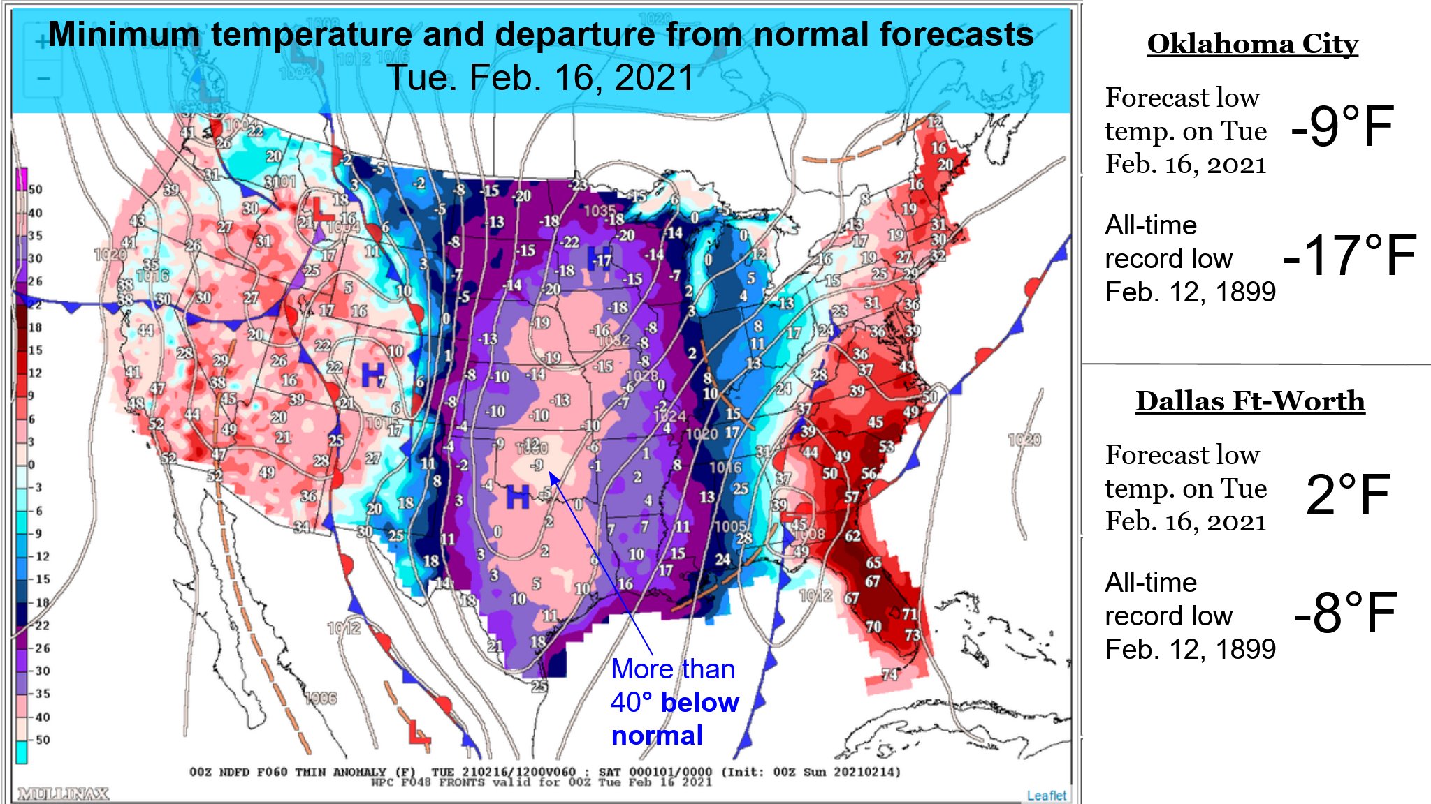
As much as a foot of snow in parts of Oklahoma and the Texas Panhandle
By Sunday, look for well-below-normal temperatures throughout the Plains and disruptive snow and ice accumulations in the South-Central region. The central and southern Plains can expect a snowy Sunday with whiteout conditions and high snow drifts. The latest forecast through Sunday night calls for as much as a foot of snow in parts of Oklahoma and the Texas Panhandle.
By Sunday night, an icy wintry mix is forecast from southern and eastern Texas to the Lower Mississippi Valley. Travel conditions Sunday night into Monday morning in these areas will be treacherous with some roads impossible to travel on safely. Look for moderate-to-heavy snow over the lower Great Lakes into the northern Mid-Atlantic by Monday morning. Winter Storm Watches have been posted for parts of the Ohio and Tennessee Valleys for heavy snowfall and dangerous ice accumulations.
Many record lows likely from the Northwest to the Plains
Teeth-chattering cold continues across the Nation’s Heartland into the first half of the upcoming week. Numerous daily record low max temps are likely to be broken from the Northwest to the Plains. High temperatures are forecast in the single digits in the Central Plains and Midwest today, struggling to get above zero Fahrenheit on Sunday.
Temperatures in the northern Rockies and Plains are forecast to be as cold as -30 degrees. Add in gusty winds and the result is life-threatening wind chills between -30 to -60 in the North-Central U.S. Wind Chill Advisories extend as far south as the Southern Plains and could persist into the start of the work-week.
WPC's Short Range Public Discussion
Major Winter Storms to Blanket the West and Plains in Heavy Snow and Ice – Icy Weather in the Mid-Atlantic
February 13, 2021 by Robert
More than 100 million Americans under winter-related watches, warnings, or advisories. Brace for record cold, significant snow accumulations, icy roads, treacherous travel, blizzard conditions as far south as Dallas and beyond. Power outages.
Heavy snow is falling across the mountains and lowlands of Washington and Oregon today with significant icing in northwest Oregon, according to the National Weather Service. Significant icing will also occur over Virginia and southern Maryland into Sunday. A major winter storm is expected to develop over the Southern U.S. Sunday lifting into the Northeast through Tuesday with a large area of snow, sleet, and freezing rain expected.
- More than 100 million Americans are now under winter-related watches, warnings, or advisories.
- Extensive impacts from coast-to-coast this weekend.
- Icy weather and slick travel conditions in the Mid-Atlantic later today.
- Major winter storm to blanket the West and Plains in heavy snow and significant ice accumulations.
- Frigid Arctic air and dangerously cold wind chills to persist in the Heartland.
Starting in the East, look for showers and thunderstorms from the Carolinas to Florida. Flash Flood Watches are in effect for parts of the Florida Panhandle and both southern Georgia and Alabama this weekend where over 2″ of rainfall is expected.
Downed tree limbs and power outages expected
Farther north, Winter Weather Advisories extend from northern North Carolina to the Delaware Valley where ice accumulations as high as a quarter inch are possible into Saturday evening. The worst impacts are likely in central Virginia where Ice Storm Warnings and Winter Storm Warnings are in effect through Saturday night, with up to a half inch of ice possible in these areas. Downed tree limbs and power outages expected. Hazardous travel conditions will be common throughout these areas of the Mid-Atlantic Saturday night and into Sunday morning.
In the West, a major winter storm is unfolding as Pacific moisture clashes with very cold temperatures from the Pacific Northwest to the Intermountain West. Significant snow accumulations are expected in western Washington and Oregon with dangerously icy conditions possible in the Willamette Valley into midday Saturday. Heavy mountain snow is anticipated in higher elevations of the West on Saturday, including portions of the Great Basin and some lower lying valleys as well.
As much as a foot of snow in parts of Oklahoma and the Texas Panhandle
By Sunday, look for well-below-normal temperatures throughout the Plains and disruptive snow and ice accumulations in the South-Central region. The central and southern Plains can expect a snowy Sunday with whiteout conditions and high snow drifts. The latest forecast through Sunday night calls for as much as a foot of snow in parts of Oklahoma and the Texas Panhandle.
By Sunday night, an icy wintry mix is forecast from southern and eastern Texas to the Lower Mississippi Valley. Travel conditions Sunday night into Monday morning in these areas will be treacherous with some roads impossible to travel on safely. Look for moderate-to-heavy snow over the lower Great Lakes into the northern Mid-Atlantic by Monday morning. Winter Storm Watches have been posted for parts of the Ohio and Tennessee Valleys for heavy snowfall and dangerous ice accumulations.
Many record lows likely from the Northwest to the Plains
Teeth-chattering cold continues across the Nation’s Heartland into the first half of the upcoming week. Numerous daily record low max temps are likely to be broken from the Northwest to the Plains. High temperatures are forecast in the single digits in the Central Plains and Midwest today, struggling to get above zero Fahrenheit on Sunday.
Temperatures in the northern Rockies and Plains are forecast to be as cold as -30 degrees. Add in gusty winds and the result is life-threatening wind chills between -30 to -60 in the North-Central U.S. Wind Chill Advisories extend as far south as the Southern Plains and could persist into the start of the work-week.
WPC's Short Range Public Discussion
TxGal
Day by day
Record snowfall blankets frozen Moscow - Ice Age Now
Record snowfall blankets frozen Moscow
February 13, 2021 by Robert
Meteorologist calls it ‘a snow Armageddon, a snow apocalypse.”
___________
Heavy snowfalls have buried Moscow, disrupting transport, delaying flights and making it tough even to walk, braving strong winds and temperatures of minus 15C (5F).
The snowfall started late Thursday and was expected to end on Sunday. Russia’s emergency service advised people to stay away from trees, warning of winds gusts of 18 meters per second (40 mph).
“It’s a real snowstorm, a snow Armageddon, a snow apocalypse. This is not a practice alert, but a combat alert,” warned Evgeny Tishkovets from the weather service Fobos before the snowfall began.
By early Saturday, snow depth in the city reached 56 cms (22 inches), Fobos said. This was close to exceeding a record high of 60 cm for accumulated snow on a Feb. 13, it said.
On Friday Moscow saw record snowfall for a Feb. 12, breaking the previous record set for the date in 1973, Russian news agencies reported.
There have been multiple flight delays at the airports in Moscow, a city of more than 12 million people. Unusually for a weekend, traffic was jammed in many places.
Around 60,000 people were working to clear the streets, the Moscow mayor’s office said.
See photos:
'Snow apocalypse' blankets frozen Moscow
Martinhouse
Deceased
TxGal, I have single digit lows still forecast for Sunday and Monday nights.
My house is so cold so when the sun actually came out earlier this afternoon, I felt warm when I stepped into the greenhouse after it had warmed up to 50. So I opened the living room doors and let some of that warm into the house. It has gotten to a nice 75-80 by now and I think I'll be able to keep the doors open another two hours. Every little bit af heat helps. This space heater is barely heating the air it blows out so I suspect it will conk out on me soon,. I have one more backup and then it will be back to the little infrared heater that I truly dislike. But at this stage, I'll just be glad if we don't lose power.
Someone came down and put the tarp on the east end of the chicken house/pen for me and and supposedly plugged some leaks in the bunny area roof. They did not properly plug the holes in the rabbit area roof, but the cages are protected from leaks anyway and tomorrow I will stuff all the cages full of bagged leaves for them to burrow in during the coldest nights. I may have to bring the ladder back to the bunny "house" and put screws into those remaining nail holes from the inside, which will do until it's warm enough to get the bad places repaired and tarred properly. I also turned on a new light bulb in my pump house.
Amazingly, there were two eggs in the chicken house. They had stopped laying about a week ago so this really surprised me. I will crack the eggs into a bowl and if they have not frozen, I will scramble them for supper. If they have frozen, I will scramble them for the two outdoor cats who have adopted me.
Winter is so exhausting! I HATE WINTER!!!!!
Last edited:
You can eat those eggs even if they froze. Won't hurt them (or you!) a bit!
Summerthyme
Summerthyme
Martinhouse
Deceased
Summerthyme, I know I can eat them but sometimes, after they are frozen, they are rubbery or maybe rather drier than they should be. And without teeth, I need them to scramble just right so I can mash them to a fine and TENDER mush. This would be easier if I liked underdone eggs, but runny eggs make me dry heave. Can't help it.....I was just born that way about food dislikes.
TxGal
Day by day
Blizzard or Armageddon for Sakhalin and the Khabarovsk Territory - Ice Age Now
Blizzard or Armageddon for Sakhalin and the Khabarovsk Territory
February 14, 2021 by Robert
While Moscow is recovering from its snowstorm, it is time for the Far East to prepare for its own snowstorm. That is not true for the entire Far East, but only for Sakhalin and the Khabarovsk Territory.
Here’s what the head of the Meteo forecasting center Alexander Vasilyevich Shuvalov thinks.
“On Sunday and Monday, a huge cyclone will develop over the Sea of Japan. In the next two days, on Tuesday and Wednesday, it will cover northern Japan, Sakhalin and the coast of the Sea of Okhotsk from Khabarovsk Territory with heavy rains and hurricane winds, ” he explained.
According to the forecast, in Yuzhno-Sakhalinsk for the period from Monday night to Wednesday inclusive, up to 80 mm of snow may fall, and the wind will increase to 30 m/s, that is, to more than 100 km/h. In addition, on Tuesday, February 16, the temperature will rise to 3-5 degrees. This means that the new snow will become moist, heavy and sticky. Wire breaks, power outages in the villages are almost inevitable.
The situation will be much more serious than in the Central region. In Moscow, about 30 mm of snow fell the day before, the wind increased to 50 km/h and the snow at a temperature of -10 … -15°C was light and flowing freely. But in Sovetskaya Gavan and Cape Terpeniya, a “true” black snowfall “is expected with winds up to 120-130 km/h”.
However, as Alexander Vasilyevich summarized, “for the Armageddon capital of Sakhalin it’s an annual practice. But the cyclone is very serious and we must be prepared for this hurricane ”.
Черная пурга или Армагеддон: что ждет Дальний Восток?
TxGal
Day by day
"Extreme freeze" - Record low February temperatures across the UK - Ice Age Now
“Extreme freeze” – Record low February temperatures across the UK
February 13, 2021 by Robert
Records fall, not just for the day, but for the entire month of February. Some records broken by “quite some way”.
___________
Fifteen weather stations across the UK recorded their lowest temperatures ever for February overnight on Wednesday, according to the Met Office.

The forecaster’s station in Braemar, Aberdeenshire, recorded a temperature of minus 23C, the lowest in the UK since 1995.
And the “extreme freeze” also saw the mercury plummet in areas in the Scottish Highlands, such as Kinbrace and Strathallan, to minus 21.3C and minus 18.2C respectively.
The lowest temperature recorded in England and Wales was at Ravensworth, in north Yorkshire, which dropped to minus 13.1C.
Oli Claydon, a spokesman for the Met Office, said that some of the records had been broken by “quite some way”.
The previous lowest temperature recorded at Strathallan was minus 13.8C – a difference of 4.4 degrees.
Elsewhere, Chillingham Barns in Northumberland dropped to minus 12C and Shap in Cumbria recorded a low of minus 11.6C.
The joint record for the lowest temperature ever recorded in the UK is held by Braemar and Altnaharra, in the Scottish Highlands, which have recorded minus 27.2C on three separate occasions.
View: https://youtu.be/iDefdxzZ-Ms
Run time is 4:59
Record low February temperatures recorded at weather stations across the UK
“Extreme freeze” – Record low February temperatures across the UK
February 13, 2021 by Robert
Records fall, not just for the day, but for the entire month of February. Some records broken by “quite some way”.
___________
Fifteen weather stations across the UK recorded their lowest temperatures ever for February overnight on Wednesday, according to the Met Office.
The forecaster’s station in Braemar, Aberdeenshire, recorded a temperature of minus 23C, the lowest in the UK since 1995.
And the “extreme freeze” also saw the mercury plummet in areas in the Scottish Highlands, such as Kinbrace and Strathallan, to minus 21.3C and minus 18.2C respectively.
The lowest temperature recorded in England and Wales was at Ravensworth, in north Yorkshire, which dropped to minus 13.1C.
Oli Claydon, a spokesman for the Met Office, said that some of the records had been broken by “quite some way”.
The previous lowest temperature recorded at Strathallan was minus 13.8C – a difference of 4.4 degrees.
Elsewhere, Chillingham Barns in Northumberland dropped to minus 12C and Shap in Cumbria recorded a low of minus 11.6C.
The joint record for the lowest temperature ever recorded in the UK is held by Braemar and Altnaharra, in the Scottish Highlands, which have recorded minus 27.2C on three separate occasions.
Run time is 4:59
Record low February temperatures recorded at weather stations across the UK
TxGal
Day by day
From Adapt 2030:
Dangerous Cold (Achilles Heel for Green Power) as IMF Starts Citizen Credit Monitoring - YouTube
Dangerous Cold (Achilles Heel for Green Power) as IMF Starts Citizen Credit Monitoring
12,836 views • Premiered 12 hours ago
View: https://youtu.be/6MvyOuXDwYc
Run time is 11:41
Synopsis provided:
A few realities to deal with at the same time now that the Grand Solar Minimum cooling is no longer hide-able. Solar panels by the millions covered in snow not seen in decades producing no power, wind turbines iced in requiring de-icing by helicopter. Blistering 50F below normal temperatures sending electric and natural gas prices to highest ever, which will draw more savings out of the public, quickening the financial collapse. IMF now wants to track individuals for creditworthiness.
Dangerous Cold (Achilles Heel for Green Power) as IMF Starts Citizen Credit Monitoring - YouTube
Dangerous Cold (Achilles Heel for Green Power) as IMF Starts Citizen Credit Monitoring
12,836 views • Premiered 12 hours ago
Run time is 11:41
Synopsis provided:
A few realities to deal with at the same time now that the Grand Solar Minimum cooling is no longer hide-able. Solar panels by the millions covered in snow not seen in decades producing no power, wind turbines iced in requiring de-icing by helicopter. Blistering 50F below normal temperatures sending electric and natural gas prices to highest ever, which will draw more savings out of the public, quickening the financial collapse. IMF now wants to track individuals for creditworthiness.
TxGal
Day by day
Martinhouse, you doing okay up there?
We've been in the low 20s for days now, going down to 12 or so overnight, they say. Have had freezing drizzle since dawn, snow is supposed to be coming in around midnight and continuing until dawn. Looking at 4"-6"+ on top of whatever frozen stuff is already down there. It's bitter cold out there.
So far, power is holding. Scares the dickens out of me to think it might go out. We'll be okay for a while if we can get the propane Little Buddy heaters to work, it'll be our first time. I'm wondering if the HVAC will hold up, but we also have space heaters for that. As long as we have power...that's the biggee.
Water is freezing quickly in the chickens and ducks housing, can't do much about that. We go out every few hours with warm water and replace it. Cows look pitiful, covered in ice on top, miserable weather. Thankfully we have a good amount of hay, but it's just bone chilling cold out there.
We're supposed to get above freezing next weekend. Of all the irony, I ordered a Spring wreath for our front door and it arrived two days ago. It's almost funny. Almost. I really, really hate winter!
Martinhouse
Deceased
I am fine here so far. Last of the space heaters loaned to me didn't really work any better than the one I've been using. But I'm warmer today than I've been so far, even though it only got up to 14 here. I'm heating several big pots of water and it makes a world of difference. I've still got to cover the plants in the greenhouse this evening and then there will be a bare minimum of things to do. Taking care of the chickens and rabbits was hell today and will be for the next two days, but it will eventually pass and I'll again be hoping for spring. Supposed to get down to 8 here tonight and 3 tomorrow night. UGH!
You take care, too, you have a lot more outdoor chores than I do.
And please all here, stay warm and be well and hope we all do not lose power through this. Only half an inch of snow so far and it's stopped for now, Hope it forgets to start back up!!!!
You take care, too, you have a lot more outdoor chores than I do.
And please all here, stay warm and be well and hope we all do not lose power through this. Only half an inch of snow so far and it's stopped for now, Hope it forgets to start back up!!!!
Last edited:
TxGal
Day by day
I am fine here so far. Last of the space heaters loaned to me didn't really work any better than the one I've been using. But I'm warmer today than I've been so far, even though it only got up to 14 here. I'm heating several big pots of water and it makes a world of difference. I've still got to cover the plants in the greenhouse this evening and then there will be a bare minimum of things to do. Taking care of the chickens and rabbits was hell today and will be for the next tow days, but it will eventually pass and I'll again be hoping for spring. Supposed to get down to 8 here tonight and 3 tomorrow night. UGH!
You take care, too, you have a lot more outdoor chores than I do.
And please all here, stay warm and be well and hope we all do not lose power through this. Only half an inch of snow so far and it's stopped for now, Hope it forgets to start back up!!!!
Glad you're doing well, we're keeping up with what needs to be done for the animals, I really feel bad for them and everyone else dealing with this mess. We're now at 22 and going to either 12 or 8 depending on who's reporting. Stuff is falling, can't quite tell if it's sleet or tiny snow pellets, but it's darn windy. Gosh, this is just miserable! Snow is supposed to start around 9 now, I think.
But,like you said, the worst is supposed to be over in just a few days, thank heavens, and next week looks lovely! Thank heavens!
Martinhouse
Deceased
Quarter to 8 PM and it's now 11 degrees and we're supposed to get down to 8 by morning. But I vbet it will get plenty colder than that. I just heard there are 400 customers without power ten or fifteen miles south of me.
If it snowed more while I was busy in the greenhouse it must have been a few on-and-off flurries, because it still looks like barely half an inch out there.
If it snowed more while I was busy in the greenhouse it must have been a few on-and-off flurries, because it still looks like barely half an inch out there.
northern watch
TB Fanatic
northern watch
TB Fanatic
northern watch
TB Fanatic
northern watch
TB Fanatic
Ok, really? If we followed that last sentence of advice, we wouldn't leave the house for 7 months output of the year!
Summerthyme
This is just crazy that you guys are 20 degrees COLDER than we are, and were just south of the Great Lakes! (Of course, I did see that crazy Fort Worth forecasts for subzero tonight, but 70 degrees by Friday! That's crazy!
Summerthyme
Summerthyme
Martinhouse
Deceased
It is 4 degrees right now here in NW central Arkansas. Predicted high today is 14 and overnight low to be 0 degrees. Looks like except for one more dip to single digit Thursday night, we will start to see gradual warming after tomorrow.
Summerthyme, could it be warmer where you are because of being downwind of such large bodies of water?
Summerthyme, could it be warmer where you are because of being downwind of such large bodies of water?
northern watch
TB Fanatic
With all respect to you, I was almost killed in a car crash due to black ice, I went to the hospital, car was totaled.Ok, really? If we followed that last sentence of advice, we wouldn't leave the house for 7 months output of the year!
Summerthyme
northern watch
TB Fanatic
northern watch
TB Fanatic
Martinhouse
Deceased
Just checked outside and it looks like we have about 6 inches of snow. It is snowing right now.....small soft flakes and straight down, thank goodness.
It is now 6 degrees out and forecast is for down to 1 degree overnight. Wonder if it'[s supposed to snow all day?
It is now 6 degrees out and forecast is for down to 1 degree overnight. Wonder if it'[s supposed to snow all day?
Yes? What does that have to do with the fact that if we followed the advice to "Don't drive during freezing temperatures after rain or snowmelt"... we'd be stuck at home?With all respect to you, I was almost killed in a car crash due to black ice, I went to the hospital, car was totaled.
That describes probably 70-80% of the days here between November 1st and April 1st...
There is no question ice, and especially black ice (which technically is an ice film thin enough that it is invisible- it doesn't even reflect light to warn you it's there) is very dangerous. You won't catch me driving on it, barring a dire emergency (or totally unexpected conditions)
But to say that you just don't drive if there is a "chance" of black ice is silly.
Summerthyme
Last edited:
TxGal
Day by day
Just checked outside and it looks like we have about 6 inches of snow. It is snowing right now.....small soft flakes and straight down, thank goodness.
It is now 6 degrees out and forecast is for down to 1 degree overnight. Wonder if it'[s supposed to snow all day?
We also got 6" of powder, rather than the heavy, wet 8+" we got the last time. We're still forecasted to be 0 officially overnight, but the local forecasters are hoping it won't be quite that cold. Ha! We got a tad bit of light snow just a while ago, forecasters say it's being squeezed out of the atmosphere as the storm system moves off, lovely...guessing that's what you're getting?
Not staying long on the net today, so many people here without power and officials pleading for conservation. I totally get it, this is NOT NORMAL for here.
Have absolutely no doubt this is GSM in the making.
Martinhouse
Deceased
I think the next 6 months or so will assure us one way or another that we are definitely into a GSM. And if we are, I will for sure be devising a way to move my chickens and rabbits into the greenhouse by next Nov. or Dec. I have only five hens and hopefully soon, a rooster, plus six rabbits each in a 30" x 30" x 18" cage. Greenhouse is 18' x 25' of usable area and ranges from5 1/2' to 7' high, so I do have room to work with, and I could do without the growing space that I'd be repurposing over the winter.