Solar Grand Solar Minimum part deux

TxGal

Day by day
TxGal, what you've posted in the last couple of days on this thread makes me wonder if we will even have a real summer next year!
Hey there, Martinhouse, I hope you're doing okay up there! How are your temps up there?

This is fast becoming one of the weirdest falls I can remember here. We're now in an exceptional drought status. I think it's been months since we've had a decent rainfall...can't even remember when our last good rain was. We're pumping into our ponds to keep them going, and we've been doing that for months! Usually that's a summer event and fall is our rainy season.

We're going to be chilly today, but not dipping down too low at night. That comes later in the week. It would be nice to see the sun, though....

And as you and I always say, I HATE WINTER!!
 

Martinhouse

Deceased
TxGal, I'm doing more or less fine. Instead of patching and tarring, my nephew built a new roof of used lumber and old sheet metal over my rabbit enclosure. Very little cost. No more leaks! He will be finishing up this afternoon. And I have several leaf bags full of loose dry leaves in a protected area to stuff in the rabbit cages if or when it gets so cold that they should have something to burrow in.

I got nine 50# bags of whole corn, nine of layer pellets, and six of rabbit pellets and my sister's new neighbor emptied them into the feed cans for me. He did this when he made a few trips down here with a total of 46 big well-packed leaf bags. Sis did all her raking for the year and had far more leaves than she needed for composting and insulating her water tank. My chickens LOVE rooting around in leaves and will be enjoying themselves while making me lots of good rich compost.

My place still needs raking badly, but I can't do it any more and plan to have my mowing guy rake everything after I get my next SS check on the 3rd of Dec.

Tree service should be here around then, too to take down a HUGE dead pine in my driveway, so by the time all that is done, I will be having a nice frugal Christmas if I even bother.

After listening to David DuByne's latest podcast, I kind of half wonder if I should bother with any of this at all! It very much called to mind something Ed Dames predicted a very long time ago about something happening that would not allow one to even stand up.....we'd be flat on the ground for about three days and would hopefully have at least water to help us wait it out, whatever it was. Well, actually, I'm not a quitter and don't intend to give up. I'll keep on keeping on no matter what happens in the future and if I die trying, that's a good way to go.

I haven't been mentioning new podcasts on this thread as much as I used to because I tend to sleep a lot later in the mornings now and by the time I come across them, you've already posted about them here.

Stay warm! I HATE WINTER!!!!!
 

TxGal

Day by day
Not much out there this morning yet in the GSM-news world, but LucyT sent this to me:

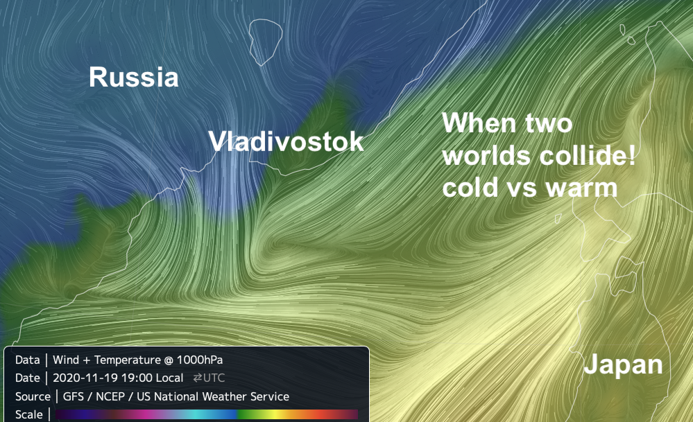
The Big Wobble : Wires and trees encrusted in ice up to 1.2cm (0.4in) thick, an occurrence not seen in 30 years in the port city of Vladivostok, winds brought down frozen trees and ice-laden power lines. A state of emergency has been declared across the region and tens of thousands left without electricity.

Wires and trees encrusted in ice up to 1.2cm (0.4in) thick, an occurrence not seen in 30 years in the port city of Vladivostok, winds brought down frozen trees and ice-laden power lines. A state of emergency has been declared across the region and tens of thousands left without electricity.


When two worlds collide, credit Earthwindmap.

A snowstorm has battered parts of the Russian Far-East, causing power cuts, transport chaos and school closures. The storm hit the Primorsky region on Thursday. In the port city of Vladivostok, winds brought down frozen trees and ice-laden power lines. A state of emergency has been declared across the region.

Rescue services and the army are scrambling to deal with the fallout. At least 150,000 homes have been left without electricity. "The situation with the electricity supply remains very difficult - the destruction is widespread," the deputy head of the region's government, Elena Parkhamenko, said. She said electricity may not be restored to some homes for several days.


The chief of the regional meteorological service, Boris Kubay, said the situation has been "aggravated by a strong gale wind that breaks everything". He said a clash between two storms, one carrying hot air and another carrying cold, caused freezing rain on Thursday. The meteorologist said wires and trees were encrusted in ice up to 1.2cm (0.4in) thick, an occurrence not seen in 30 years.

Local media said some hospitals in Vladivostok, including one treating coronavirus patients, had to use back-up generators for electricity. Power engineers were working to restore power to these hospitals, but recovery work has been complicated by snow and wind. Meanwhile, there were long delays for public transport and flights as freezing conditions hampered travel.

Photos and videos published by local authorities and on social media gave an indication of the chaos. One viral video filmed in Vladivostok showed a man narrowly evading a giant slab of concrete that plummeted from a high-rise apartment block and crushed his car. Forecasters hope the snow and ice will melt as temperatures gradually increase in the coming days.

View: https://twitter.com/jonnytickle/status/1329702238957268992
 

TxGal

Day by day
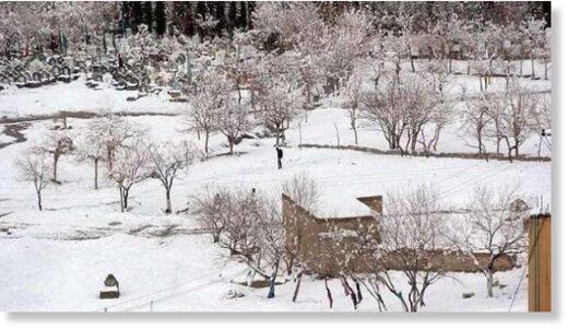
Heavy Snowfall Closes 86-km-long Road in Kashmir, Northern India - Electroverse

snow-india-road-2-1-e1606219346734.jpg


HEAVY SNOWFALL CLOSES 86-KM-LONG ROAD IN KASHMIR, NORTHERN INDIA
NOVEMBER 24, 2020 CAP ALLON

The historic 86km-(53.5-mile)-long Mughal road, which connects the northern Indian regions of Shopian in Kashmir with Rajouri and Poonch in Jammu, has been closed to all traffic on Monday following a foot+ of fresh snowfall.

The new snow combined with sub-zero temperatures and impressive accumulations already on the ground to deliver treacherous driving conditions, avalanches, and the suspension of all traffic in the region–a reality which means many remote towns and villages have now been completely cut off.

The National Highway Authority of India (NHAI) and Border Roads Organisation (BRO) have reportedly deployed two snow cats along the Mughal road, but have said further snowfall is hampering the clearing efforts.

View: https://twitter.com/LadakhNews/status/1331153379108614145


View: https://youtu.be/zQHdFir46A4


Sub divisional magistrate, Gurez Mudasir Ahmad told KNS that food and supplies have been delivered to the worst hit and hardest to reach regions.

Ahmad says medicines have also been stocked up in the Gurez Valley.

snow-india-road-2-edited.jpg

Snow-clearing efforts, Mughal Road, Razdan Top, Gurez.

The substantial snow cover in northern India is creating issues down south, too. The nation’s capital city, Delhi has suffered record low temperatures through the months of October and November: October averaged as Delhi’s coldest since 1962, while November has suffered its coldest temperature in 17 years.

As Mahesh Palawat, an expert at Skymet Weather explains: the dip in the capital’s mercury is due to the icy cold winds blowing in from the snow-laden northern mountains.

And looking forward, there seems to be no let-up to India’s cold and snow in sight–with heavy snowfall persisting today, Tuesday, November 24:

View: https://twitter.com/uniindianews/status/1331199194518888448


View: https://twitter.com/PBNS_India/status/1331065986976415746


Northern India’s substantial snow cover is also assisting in driving the Northern Hemisphere’s Total Snow Mass to levels some 400 gigatons above the 1982-2012 average:


FMI [globalcryospherewatch.org].

The COLD TIMES are returning, the mid-latitudes are REFREEZING in line with historically low solar activity, cloud-nucleating Cosmic Rays, and a meridional jet stream flow.

Both NOAA and NASA appear to agree, if you read between the lines, with NOAA saying we’re entering a ‘full-blown’ Grand Solar Minimum in the late-2020s, and NASA seeing this upcoming solar cycle (25) as “the weakest of the past 200 years”, with the agency correlating previous solar shutdowns to prolonged periods of global cooling here.

Furthermore, we can’t ignore the slew of new scientific papers stating the immense impact The Beaufort Gyre could have on the Gulf Stream, and therefore the climate overall.


Prepare accordinglylearn the facts, relocate if need be, and grow your own.
 

BenIan

Veteran Member
Our fall has been very warm & dry. My garden is still chugging along. I had pulled a bunch of plants and for some reason I left a Seminole pumpkin plant that was struggling along. It has now exploded and grown exponentially in the last month with many small fruit on it. Also, I found two volunteer tomato seedlings by the chicken coop in October and put them into a garden bed to see what the would do. Well one of them is starting to flower on November 23.
 

TxGal

Day by day
Martinhouse, looks like that line of thunderstorms with the cold front is heading your way, too, I guess overnight. There were tornado warnings north of us near DFW, hopefully won't be too bad here when it comes in after midnight.

I really hate night storms! Keep an eye on that weather of yours!
 

Martinhouse

Deceased
It's been raining here for several hours now, but nothing heavy and no rough stuff. Thank goodness any rain in the ten-day forecast isn't on nights that call for below freezing temps. There's a bunch of those coming next week so I guess winter's here for sure now. And I truly do HATE WINTER!!!!!

Got the garden hose drained today and a bunch of the raking done. Nephew finished the roof over the rabbit area this afternoon and then tarred all the nail holes in the use metal panels and also finished the tarring of the roof of the chicken house/pen area which was built a year ago. His kids were here and the boy who is sixteen needs to earn a little money for parts cuz he's fixing a used 4-wheeler he got. So I had him rake and spread pine straw, then put most of the fallen leaves into the big compost bin and a few odds and ends type little chores that his deteriorating spine allows him to do. Little sister helped him so I paid her a little, too.

Nephew noticed a couple of the hens seem to be coughing so tomorrow he's bringing down some tetracycline to put in their water.

He finally accepted a little bit of money from me. Up til now he mostly would only take money for the materials he's been having to buy for the various projects.

Only big outdoor things that can't be postponed any longer are insulating the outdoor faucet and getting four bags of rabbit feed scooped into eight 5 gallon pails that I can handle. And now I can do it without rain leaking on me from overhead. And it's a sit-down job that I can handle easily.

So I've had a good day and am a few steps closer to being able to deal with the coming winter, even if it turns out to be colder than I'd like.

ADDED: I just looked at Intellicast Radar and it looks like there's another batch of rain headed this way and appears like the kind that isn't as gentle as what we've had so far today. UGH!
 

TxGal

Day by day
Wow, between this posting and your previous one from a few day ago, you have gotten one heck of a lot done! That's huge!!

Hopefully that second line wasn't too bad for you. The line came through here around 1230 - 0100. Thankfully wasn't ugly, just strong wind and heavy rain. We desperately needed the rain, it hasn't rain here since early September. Fire danger was becoming serious, and grass just went dormant early.

Another storm line comes in early Friday supposedly with a lot of rain, then another on Sunday...I think that one could be severe. What a strange year!
 

TxGal

Day by day
Toronto Obliterates All-Time November Snowfall Records - Electroverse

Toronto-snow-Nov-e1606302928611.jpeg


TORONTO OBLITERATES ALL-TIME NOVEMBER SNOWFALL RECORDS
NOVEMBER 25, 2020 CAP ALLON

Environment and Climate Change Canada (ECCC) had issued multiple snowfall warnings across the southeast for this past weekend, and the weather did not disappoint.

On the back of its warning that the NWT will suffer a “colder-than-average winter” with “more snow,” ECCC reports that 19.4 cm (7.64 inches) of powder fell at Pearson airport Sunday, total’s which obliterated the previous Nov. 22 record of 7.6 cm (2.99 inches) set in 2007 (solar minimum of cycle 23).

For a similarly significant amount of snowfall during the month of November you have flip the record books back 80 years, to Nov. 26, 1940, when the city saw 16.5 cm (6.5 inches). Sunday’s totals finished 3rd in the list of snowiest November days on record, behind Nov. 30, 1940, and Nov. 24, 1950.

View: https://twitter.com/MelsonDsouza/status/1330655796812779523


And there’s more.

As pointed out by Toronto Weather Records, with 17cm (6.69 inches) of snow cover on Monday the day went down as Toronto’s “deepest” Nov. 23 since records began in 1955:

View: https://twitter.com/YYZ_Weather/status/1330867075297013762


In addition, with 11 cm (4.33 inches) of snow cover remaining on Tuesday, the day entered the books as the city’s “deepest” Nov. 24 on record:

View: https://twitter.com/YYZ_Weather/status/1331243806780493829


And finally, having two consecutive November days with a snow depth of ≥10cm puts this run in 3rd place for the longest stretches on record.

If the run continues, 1st place will be reached by Thursday, and will match both last year’s stretch (Nov. 12 to Nov. 15) and 1997’s (Nov.14 to Nov. 17):

View: https://twitter.com/YYZ_Weather/status/1331240020980719618


Looking ahead, a few additional inches are forecast for the Toronto area Wednesday, flurries that will threaten the above record.

And then eyeing further forward, the GFS is suggesting more substantial snowfall could hit next week, as the calendar flips to December.

Stay tuned for updates.

The COLD TIMES are returning, the mid-latitudes are REFREEZING in line with historically low solar activity, cloud-nucleating Cosmic Rays, and a meridional jet stream flow.

Both NOAA and NASA appear to agree, if you read between the lines, with NOAA saying we’re entering a ‘full-blown’ Grand Solar Minimum in the late-2020s, and NASA seeing this upcoming solar cycle (25) as “the weakest of the past 200 years”, with the agency correlating previous solar shutdowns to prolonged periods of global cooling here.

Furthermore, we can’t ignore the slew of new scientific papers stating the immense impact The Beaufort Gyre could have on the Gulf Stream, and therefore the climate overall.


Prepare accordinglylearn the facts, relocate if need be, and grow your own.
 

TxGal

Day by day
Denver Breaks November Snowfall Record - Electroverse

Denver-Nov-Snow-e1606298251563.jpg


DENVER BREAKS NOVEMBER SNOWFALL RECORD
NOVEMBER 25, 2020 CAP ALLON

Denver just busted its first daily November snow record since 1994 (since the solar minimum of cycle 22).

Colorado’s latest snowstorm may now be wrapping up, but it certainly left its mark, gaining a spot in the history books.

Denver International Airport received 5 inches (12.7 cm) of snow on Tuesday, November 24 — a new daily record for the date, busting the old mark of 4 inches (10.2 cm) set back in 1946 (solar minimum of cycle 17).

View: https://twitter.com/WxReppert/status/1331305905837641729


Even more notably, and as touched on above, this was the first new daily November snow record in the city since 1994 (solar minimum of cycle 22).

Another rarity lies within the heavy and wet nature of the snow.

Colorado is accustomed to light and fluffy powder but Tuesday’s hefty blanketing, while great for making snowmen and snowballs, was difficult to shovel. However, the snow’s high water content will only prove beneficial for the state’s ongoing drought: the 5 inches at DIA melted down to just under a half of an inch of liquid, making it Denver’s fifth wettest day in all of 2020.

Related article:

Wellington set for Cloudiest November ever, Seoul breaks Rainfall Record — “Cosmic Ray Flux” Explained (electroverse.net)

Tuesday’s snow totals across the rest of the metro area reportedly ranged from 3 to 6 inches (7.6 to 15.2 cm), with heavier amounts up to 10 inches (25.4 cm) in the western suburbs.

View: https://twitter.com/accuweather/status/1331296924796923909


The COLD TIMES are returning, the mid-latitudes are REFREEZING in line with historically low solar activity, cloud-nucleating Cosmic Rays, and a meridional jet stream flow.

Both NOAA and NASA appear to agree, if you read between the lines, with NOAA saying we’re entering a ‘full-blown’ Grand Solar Minimum in the late-2020s, and NASA seeing this upcoming solar cycle (25) as “the weakest of the past 200 years”, with the agency correlating previous solar shutdowns to prolonged periods of global cooling here.

Furthermore, we can’t ignore the slew of new scientific papers stating the immense impact The Beaufort Gyre could have on the Gulf Stream, and therefore the climate overall.


Prepare accordinglylearn the facts, relocate if need be, and grow your own.
 

TxGal

Day by day
Galyat, Pakistan pummelled by another spell of heavy snow - a foot in 24 hours -- Earth Changes -- Sott.net

Galyat, Pakistan pummelled by another spell of heavy snow - a foot in 24 hours

Ateeq Abbasi
Express Tribune (Pakistan)
Tue, 24 Nov 2020 19:36 UTC

Second spell of heavy snowfall continues in Galyat

Tourists stranded as Thandiani, Nathiagali, Ayubia receive one-foot snow

Continuous heavy snowfall in the hilly areas of Hazara division on Monday brought the mercury below the freezing point, however, the main Muree Road remained open for traffic but roads to and from Koza Gali, Khanspur Road, Bakot, Nathia Gali Road, Boi Sawar Gali Road, were closed.

In the second spell of snowfall in the current winter season, Thandiani, Nathiagali and Ayubia received up to one foot of snow during the last 24 hours where a large number of tourists were stranded because of the slippery road conditions.


Snow-clearing machinery of the Galyat Development Authority (GDA), the Khyber-Pakhtunkhwa Highways Authority (KPHA) and the works department has been deployed at various places of Galyat to meet any eventuality.

View: https://youtu.be/1tuJ6E-AMtk


View: https://youtu.be/LeGEu9BefcA


View: https://youtu.be/gQDS4yhrd98


The GDA Spokesperson Ahsan Hameed said that the authority had issued an advisory for the tourists and locals to avoid unnecessary travel because of the slippery roads after continuous snowfall and rain.

The Met Department has forecast more snowfall in the next 48 hours in the upper parts of Hazara division. In the wake of the forecast, the GDA has directed its staff to remain vigilant and present in Galyat to respond to any emergencies and clear the road.

Because of the cold weather, there is a huge increase in the prices of firewood, however, in some areas, firewood is not available. The forest department has imposed a ban on felling trees in jungles. The recent snowfall is expected to continue till Thursday

(With input from APP)

Comment: The earlier spell of heavy snow: Record November snowfall of 3 feet hits northern Pakistan, blocking roads
 

TxGal

Day by day
"Dangerous" Blizzards Battered Labrador Tuesday: Almost 3 Feet Buried Some Parts-the most November Snow in Recorded History - Electroverse


Lab-snow-Nov-e1606307364989.jpg


“DANGEROUS” BLIZZARDS BATTERED LABRADOR TUESDAY: ALMOST 3 FEET BURIED SOME PARTS–THE MOST NOVEMBER SNOW IN RECORDED HISTORY
NOVEMBER 25, 2020 CAP ALLON

By Tuesday’s end (Nov. 24), record breaking volumes of snow had buried Labrador, Canada — unprecedented accumulations that almost doubled previous benchmarks.

More than 50 cm (1.64 ft) of snow had already been reported in central parts of Labrador early Tuesday morning, with heavy snow continuing through the day bumping totals to 80 cm (2.6 ft) and beyond in some parts.

Blizzard warnings remained in effect all day as winds strengthened to create near zero visibility and treacherous travel conditions, reports theweathernetwork.com.

“It’s just going to be a dirty, dirty day across Labrador, really — no better way to put it,” said Mike Vandenberg, a meteorologist with Environment and Climate Change Canada (ECCC), on Tuesday morning.

“Travel is not recommended,” he added: “If you can stay home, that would be great.”

The same snowstorm that delivered “record-obliterating” totals to Toronto on Sunday barreled through southern Quebec Monday, smacking the most easterly Canadian province Monday night through Tuesday:

View: https://twitter.com/PhilipEarle/status/1331182969881391104


According to Weather Network meteorologist Matt Grinter, Happy Valley-Goose Bay had picked-up 59 cm (1.94 ft) before 9AM on Tuesday, with the snow falling at an “unbelievable rate” of 5-10 cm per hour.

By Tuesday evening, a whopping 70 cm (2.3 ft) was reported.

Grinter pointed out these totals not only broke the record for Happy Valley-Goose Bay’s snowiest November day in recorded history but almost doubled it, beating-out the previous benchmark of 40.6 cm (1.33 ft) from 1944 (solar minimum of cycle 17).

“There is the potential to also break their 2-day November snowfall record of 70.6 cm [in a single day],” adds Grinter, with 70 cm having settled by the early evening and therefore a few hours left to run.

View: https://twitter.com/GarrettBarry/status/1331291224947437568


View: https://twitter.com/chelseaabarrett/status/1331235774193397760


As a result of the unprecedented powder and rapidly deteriorating conditions, schools were closed in both Happy Valley-Goose Bay and North West River, as well as the regional College of the North Atlantic campus.

In addition, Canada Post issued a red alert for mail delivery in Happy Valley-Goose Bay and North West River, meaning the agency is suspending service for the day and isn’t sending workers outdoors due to “unsafe conditions”.

Air Borealis cancelled its Tuesday flights to coastal Labrador, citing the weather. And while the blizzard warnings stretched up the coast from Postville to Hopedale on Tuesday, conditions were expected to gradually taper-off through Tuesday night into Wednesday.

The COLD TIMES are returning, the mid-latitudes are REFREEZING in line with historically low solar activity, cloud-nucleating Cosmic Rays, and a meridional jet stream flow.

Both NOAA and NASA appear to agree, if you read between the lines, with NOAA saying we’re entering a ‘full-blown’ Grand Solar Minimum in the late-2020s, and NASA seeing this upcoming solar cycle (25) as “the weakest of the past 200 years”, with the agency correlating previous solar shutdowns to prolonged periods of global cooling here.

Furthermore, we can’t ignore the slew of new scientific papers stating the immense impact The Beaufort Gyre could have on the Gulf Stream, and therefore the climate overall.


Prepare accordinglylearn the facts, relocate if need be, and grow your own.
 

TxGal

Day by day
Record-setting blizzard paralyzes Labrador - Ice Age Now

Record-setting blizzard paralyzes Labrador
November 25, 2020 by Robert


More snow in a matter of hours than YEARLY totals for many major Canadian cities
___________

A record-setting blizzard shut down parts of Labrador, forcing the closures of roads, government offices and flights Tuesday, as well as schools.

The potent storm had already slammed Ontario and Quebec with widespread, heavy snow last weekend.

Labrador-23-Nov-2020.png


After picking up 75 cm of snow from just one potent storm, Happy Valley-Goose Bay has now officially outsnowed several major Canadian cities’ annual snowfall totals. That’s more snow than what somewhere like Nanaimo, British Columbia would see in an entire year.

It’s an historic early season snowfall for the books, breaking several significant records for the region. Those records include the snowiest day in November history and the largest two-day November snowfall.

At one point, the snow was falling at an astonishing rate of 5-10 cm per hour.

See video:
The Weather Network - Labrador just outsnowed YEARLY totals for many major Canadian cities

See video:
The Weather Network - PHOTOS: Labrador buried under historic 75 cm of snow, towns shut down
 

TxGal

Day by day
Toronto Shatters November Snowfall Records - Ice Age Now

Toronto Shatters November Snowfall Records
November 26, 2020 by Robert

Obliterated daily record and finished 3rd on the list of snowiest November days on record.

On the back of its warning that the Northwest Territories will suffer a “colder-than-average winter” with “more snow,” Environment and Climate Change Canada (ECCC) reports that 19.4 cm (7.64 inches) of powder fell at Pearson airport Sunday, which shattered the previous Nov. 22 record of 7.6 cm (2.99 inches) set in 2007 (solar minimum of cycle 23).

For a similarly significant amount of snowfall during the month of November you have flip the record books back 80 years, to Nov. 26, 1940, when the city saw 16.5 cm (6.5 inches). Sunday’s totals finished 3rd in the list of snowiest November days on record, behind Nov. 30, 1940, and Nov. 24, 1950.

Toronto Obliterates All-Time November Snowfall Records (electroverse.net)
 

TxGal

Day by day
Solar Cycle 25 Releases its first Big CME - Electroverse

20201124_0624_c2_512-1-e1606387124223.jpg


SOLAR CYCLE 25 RELEASES ITS FIRST BIG CME
NOVEMBER 26, 2020 CAP ALLON

“AR2786” was already a big sunspot, but it has just grown even bigger with the addition of multiple trailer spots behind the primary dark core:


AR2786 with multiple trailer spots.

Martin Wise of Trenton, Florida was monitoring the active region on November 25 when he caught an explosion in progress among the new additions:


A recent AR2786 “explosion” [courtesy of spaceweather.com].

C-class solar flares are likely on Nov. 26 as the sunspot continues to develop, risking further electrical disturbances and radio blackouts here on Earth–such as occurred during the late hours of Nov. 23 (23:35 UT), when AR2785 produced a C4-class solar flare that hurled a plume of plasma more than 350,000 km across the sun, which led to a pulse of ultraviolet radiation hitting Earth, briefly ionizing the top of our atmosphere. This, in turn, caused a shortwave radio blackout over the South Pacific, including eastern Australia and all of New Zealand.

NASA’s Solar Dynamics Observatory recorded the violent Nov. 23 explosion:


NASA’s Solar Dynamics Observatory (Nov. 23).

More solar flares are in the offing.

Three of the biggest sunspots of young Solar Cycle 25 (AR2783, AR2785, and AR2786) are either facing Earth or turning in our direction. Each poses a significant threat for further C-class flares (like the one shown above) and even stronger M-flares.

For reference, NASA classifies solar flares according to their strength: the smallest are A-class, followed by B, C, M and X, the largest.

FIRST BIG CME

During this general increase in activity, the Sun also released its biggest coronal mass ejection (CME) of the new solar cycle so far, on Nov 24.

Fortunately, this titanic eruption (shown below) came off the far side of the Sun, meaning it won’t result in any big geomagnetic storms here on Earth.


CME on Nov 24 [ you can watch the “movie” yourself at soho.nascom.nasa.gov, simply select the date and hit “generate”].

View: https://twitter.com/erikapal/status/1331423185179348992


Looking forward though, the newly formed cluster of trailer spots behind the primary dark core is something of a concern, particularly given the timing of their materialization: just as the magnetic region crosses the Earth-facing disc.

If an M-class flare (or worse) were to be fired in our direction, the implications could prove somewhat problematic, to say the least. Such a powerful outburst would be more than capable of knocking-out localized electrical grids, just as occurred in Quebec in 1989 (more on that linked below).

One more factor to consider, the risks are even greater today given the ongoing waning of Earth’s magnetic field due to an intensifying GSM and Pole Shift (more on that, too, linked below).

Why a Strong Solar Cycle 25 still Spells Disaster (electroverse.net)

Coronal Mass Ejections and their Increasing Threat Moving Forward (electroverse.net)

Prepare accordinglylearn the facts, relocate if need be, and grow your own.
 

TxGal

Day by day
STEVE’s Little Green Cannonballs of Light - Electroverse

Harlan-Thomas-Yamnuska-Steve-Aurora_041018-19_1523742195_lg-1-e1606392723514.jpg


STEVE’S LITTLE GREEN CANNONBALLS OF LIGHT
NOVEMBER 26, 2020 CAP ALLON

Just when you thought “STEVE” couldn’t get any weirder, a new paper published in the journal AGU Advances reveals that the luminous purple ribbon is often accompanied by green cannonballs of light that streak through the atmosphere at 1000 mph.

[Below is an abridged version of Dr. Tony Phillip’s excellent article–the full version of which is available at spaceweatherarchive.com, dated November 22, 2020.]

STEVE (Strong Thermal Velocity Enhancement) is a relatively recent discovery, first spotted and photographed by Canadian citizen scientists around 10 years ago. It looks like an aurora, but it is not. The purple glow is caused by hot (3000 °C) rivers of gas flowing through Earth’s magnetosphere faster than 13,000 mph. This distinguishes it from auroras, which are ignited by energetic particles raining down from space.

“Citizen scientists have been photographing these green streaks for years,” says Joshua Semeter of Boston University, lead author of the new paper. “Now we’re beginning to understand what they are.”

There is a dawning realization that STEVE is more than just a purple ribbon, as photographers routinely catch it flowing over a sequence of green vertical pillars known as the “picket fence” (example shown below).


“Picket fence” below STEVE: Taken by Harlan Thomas
on April 10, 2018 in Alberta, Canada.

These aren’t auroras either.

And now, Semeter’s team has identified yet another curiosity: “Beneath the picket fence, photographers often catch little horizontal streaks of green light,” explains Semeter: “This is what we studied in our paper.”

Entitled The Mysterious Green Streaks Below STEVE, Semeter’s research involved gathering as many images of these little horizontal streaks as possible, and citizen scientists across North America and New Zealand were only too happy to help:


[spaceweatherarchive.com]

In a few cases, the same streaks were captured by widely-separated photographers, allowing a triangulation of their position:

triangulation.jpg

[spaceweatherarchive.com].

Upon analyzing dozens of high-quality images, the researchers came to these three conclusions:

1. The streaks are not in fact streaks, they are instead point-like balls of gas moving horizontally through the sky. In photos, the ‘green cannonballs’ are smeared into streaks by the exposure time of the cameras.

2. The cannonballs are typically 350 meters wide, and located about 105 km above Earth’s surface.

3. The color of the cannonballs is pure green–much moreso than ordinary green auroras, reinforcing the conclusion that they are different phenomena.

So, what exactly are STEVE’s green cannonballs?

Semeter and his team believe they are a sign of turbulence: “During strong geomagnetic storms, the plasma river that gives rise to STEVE flows at extreme supersonic velocities. Turbulent eddies and whirls dump some of their energy into the green cannonballs.”

This idea may explain their prevalence of late: given ongoing waning of Earths magnetic field (thought to be tied to a GSM and Pole Shift), geomagnetic storms could-well be having a bigger impact closer to the ground, with streams of plasma penetrating deeper into Earth’s atmosphere.

Semeter’s musings may also explain their pure color, writes Dr. Phillips. Auroras tend to be a mixture of hues caused by energetic particles raining down through the upper atmosphere. The ‘rain’ strikes atoms, ions, and molecules of oxygen and nitrogen over a wide range of altitudes. A hodge-podge of color naturally results from this chaotic process. STEVE’s cannonballs, on the other hand, are monochromatic. Local turbulence excites only oxygen atoms in a relatively small volume of space, producing a pure green at 557.7 nm; there is no mixture.

“It all seems to fit together, but we still have a lot to learn,” concludes Semeter. “Advancing this physics will benefit greatly from the continued involvement of citizen scientists.”

According the mainstream position, however, when it comes to science, “you must not do your own research“. By this logic, citizen scientists around the world should immediately cease all endeavors and their groups be disbanded.
But why? What do the powers-that-be deem so threatening and dangerous with people exploring the reality around them, and what business is it of theirs how a person searches for the truth?

(note - I think the below is part of the article...getting harder to tell on Electroverse sometimes)

The elite’s plan, it now seems obvious, is to herd society down one very specific thought-path, a path which offers a very narrow set of answers to all life’s questions and problems. People are misled into thinking science is definitive, that there is one simplistic answer to each and every query–but science doesn’t work on consensus, and even the most seemingly far-reaching hypothesis, if properly and honestly devised, has about as much chance being proven correct as any widely-held theory.

Nothing at all is settled.

Questioning everything is key, and mistakes are part-and-parcel.

This is science.
 

TxGal

Day by day
Possible dzud in Mongolia - Ice Age Now

Possible dzud in Mongolia
November 26, 2020 by Robert

25 Nov 2020 – Dzud is possible in Bayankhongor, Uvurkhangai, Dundgovi and Gobi-Altai.

The Institute of Meteorology, Hydrology and Environmental Research has released a variety of ground observation and satellite data related to droughts, snowstorms and dzuds. As of November 20, more than 50 percent of the area was covered with snow.

Of these, Altai, Khangai, Khentei, Khuvsgul highlands, Kharkhiraa Turgen mountains, Khan Khukhii mountain range more than 20 cm. (..)

According to the dzud risk map, about 40 percent of the country is at high risk and about 30 percent is moderately at risk.

The risk of dzud is very high in Bayankhongor aimag, eastern Gobi-Altai, Uvurkhangai and Dundgovi as a whole, and some areas of Umnugovi, Dornogovi, Tuv and Sukhbaatar aimags.

Thanks to Argiris Diamantis for this info(I have asked him for a link.)
_________

What is a dzud?

According to Wikipedia, a dzud is a Mongolian term for a severe winter in which large number of livestock die, primarily due to starvation due to being unable to graze, in other cases directly from the cold. There are various kinds of dzud, including white dzud, which is an extremely snowy winter in which livestock are unable to find nourishing foodstuff through the snow cover and starve.

One-third of Mongolia’s population depends entirely on pastoral farming for its livelihood, and harsh dzuds can cause economic crises and food security issues in the country. This natural disaster is unique to Mongolia.
 

TxGal

Day by day
Australia's 2-day Heatwave over-hyped, as December 1st threatens Record Cold and rare Summer Snow - Electroverse

Dec-2-chill-1-e1606473533192.png


AUSTRALIA’S 2-DAY HEATWAVE OVER-HYPED, AS DECEMBER 1ST THREATENS RECORD COLD AND RARE SUMMER SNOW
NOVEMBER 27, 2020 CAP ALLON

While the mainstream media reports “Australians are set to sizzle through the most dangerous heatwave of the year so far,” what they also fail to mention is that 1) such bursts of heat are typical for this time of year, 2) the conditions will last fewer than three days, and 3) they will be closely followed by record-cold Antarctic air and even rare December snow.

The MSM is using images of last year’s wildfires in the hope that their readers are too trusting and/or stupid (or perhaps too busy) to do their own research.

Chief warm-mongers, The Guardian are warning that Friday’s temperatures will lead to heat-related illness such as dizziness, tiredness, irritability, shallow breathing, vomiting and confusion.

However, one quick check of the weather charts reveals the only vomit-inducing and confusing things here are the MSM’s bias reporting, not the mercury: 1) 30C to 40C is hardly unprecedented at this time of year, and 2) the heat is also very fleeting, running from the evening of Nov 26 and concluding, for most, on Nov 28.

Moreover, the balmy temps will be replaced by record polar cold as the calendar flips to December (a setup serving as yet another example of the prevalence of swing between extremes during times of low solar activity).

Both the GFS and ECMWF are currently in alignment here, with each weather model foreseeing Antarctic air sweeping in from the west on Tuesday and engulfing central and southern regions by Wednesday:


GFS 2m Temp Anomalies (C) for Dec 2.

The picture turns a little uncertain after that, but by then the higher elevations of Tasmania are forecast to have received a rare dumping of summer snow, perhaps as much as 2.2 inches (5.9 cm):


ECMWF “new snow” forecast for Dec 1 [windy.com].


GFS “total snowfall” for Dec 1 [tropicaltidbits.com].

Eyeing east and across the Tasman sea, New Zealand’s South Island is on for some truly astonishing December totals by the end of next week.

The cold air mass that engulfed southern Australia at the start of the week is set to deliver bone-chilling lows and up to 31.8 inches (80.8 cm) of summer snow down the western mountain ranges:


ECMWF “new snow” forecast from Nov 27 to Dec 6 [windy.com].

These dumpings could threaten all-time December snowfall records.

Stay tuned for updates.

Winter 2020 was a relatively mild one across New Zealand, but with the arrival of spring came a violent switch in fortunes.

September 1 saw widespread snowfall across the South Island with accumulations building at abnormally low-levels: inland parts of Canterbury and Otago, for example, saw 5+cm (2+inches):

New Zealand’s first day of Spring delivers “Bitterly Cold” Temperatures and “Widespread Snow” to the South Island (electroverse.net)

The cold and snowy conditions lingered through September, and conspired to deliver 1.3 feet of spring snow to the nation’s ski-fields mid-month:

1.3 Feet of Spring Snow Buries New Zealand’s Ski-fields + there’s much more where that came from (electroverse.net)

The COLD TIMES are returning, the mid-latitudes are REFREEZING in line with historically low solar activity, cloud-nucleating Cosmic Rays, and a meridional jet stream flow.

Both NOAA and NASA appear to agree, if you read between the lines, with NOAA saying we’re entering a ‘full-blown’ Grand Solar Minimum in the late-2020s, and NASA seeing this upcoming solar cycle (25) as “the weakest of the past 200 years”, with the agency correlating previous solar shutdowns to prolonged periods of global cooling here.

Furthermore, we can’t ignore the slew of new scientific papers stating the immense impact The Beaufort Gyre could have on the Gulf Stream, and therefore the climate overall.


Prepare accordinglylearn the facts, relocate if need be, and grow your own.
 

TxGal

Day by day
Record snowfall in Minnesota - Ice Age Now

Record snowfall in Minnesota
November 27, 2020 by Robert

Admittedly it beat the previous record by only a small amount, but still, a record is a record.

The official snowfall total at the Rochester International Airport of 2.9″ is the new daily record snowfall record for Rochester.

This beat the previous record of 2.2″ set back in 1996.

Rochester-record-snowfall.png


Areas in Filmore and Winona Counties sent in reports of 4-5″ of snow. Even the southeastern portion of Olmsted County report up to 3″ of snow.

Recapping a snowy Tuesday; Mild holiday weekend (kttc.com)

Thanks to Clay Olson for this link
 

Martinhouse

Deceased
My coment toRobert about this article just posted.....I don't think over 1/2" is such a small difference. And Rochester is in the southern part of the Minnesota!
 

TxGal

Day by day
The Oppenheimer Ranch Project has a new podcast out:

Florida Chills Out - Snow For Texas & Georgia - Fire and Ice Map - The Ether - Elongated Skulls - YouTube

Florida Chills Out - Snow For Texas & Georgia - Fire and Ice Map - The Ether - Elongated Skulls
2,544 views • Premiered 10 hours ago

Run time is 33:09

Synopsis provided:

Florida to welcome December with major cold front https://bit.ly/39nIGjG
Storm brings snow to Arizona's high country after Thanksgiving https://bit.ly/39mN1Ur
Monday night storm 'significant' snowfall to Northeast Ohio https://bit.ly/3mlEN2I
First solid snow to hit part of Michigan on Monday https://bit.ly/2V7zkk1
First big snow of the season possible next week in metro Detroit https://bit.ly/36gJdSR
2 systems developing with just days left in 2020 hurricane season https://bit.ly/39iZKYh
GFS Model Total Snow US https://bit.ly/36fVLtm
GFS Model Temperature Contour https://bit.ly/2JdKyAU
GFS Model Total Snow Europe https://bit.ly/332e83w
Heavy Rainfall to Spread Across the Southeast; Mild Conditions for Much of the East https://www.weather.gov/
A huge solar explosion stops radio communication on Earth https://bit.ly/39jc8rj
Worldwide Volcano News http://bit.ly/2v9JJhO
Fire and ice: New database maps and classifies the dangers of glacierized volcanoes Physics.Org is an Embarrassment - Read The Title... https://phys.org/news/2020-11-ice-dat...
The world is set to change on December 21… and it’s literally written in the stars https://bit.ly/2VcX2eK
Scientists Find Earth’s Atmosphere Is Much Bigger Thant We Thought, it Encompasses the Moon https://bit.ly/2V957AO
Physicists Say Universe Filled With Mystery Substance Called “Quintessence” LMFAO - https://bit.ly/33ow1cw
Gods of Antiquity: Elongated Skulls From Africa https://bit.ly/33nMPQR
The Great Reset: If Only It Were Just a Conspiracy https://bit.ly/3q75MBd
 

TxGal

Day by day
Heavy Snow and Lowest-Maximum-Temperature-Records Fall across India - Electroverse

snow-india-Nov-2020-e1606474609582.jpg


HEAVY SNOW AND LOWEST-MAXIMUM-TEMPERATURE-RECORDS FALL ACROSS INDIA
NOVEMBER 28, 2020 CAP ALLON

Heavy snow continued in northern India yesterday, Nov. 26, as southern regions continued to register anomalous, often record-breaking cold.

As originally reported by sify.com, the city of Shimla, Himachal Pradesh was greeted with a fresh spell of snow and sub-zero temperatures on Thursday, November 26 (see featured image), with Keylong district clocking the northern state’s lowest temperature, a nippy -2.6C (27.3F).

District authorities have now commenced snow-clearing operations at the Kharapathar-Shimla highway as drifts totaling many feet blocked key passes.

View: https://twitter.com/pinankjoshi/status/1332199564758183937


WALTAIR AND CHANDIGARH RECORD THEIR LOWEST-MAXIMUM NOVEMBER TEMPERATURES FOR 11 AND 10 YEARS, RESPECTIVELY

In the southern port city of Waltair (aka Vizag or Visakhapatnam) cold winds blowing down from the snow-laden north drove the mercury to a daytime high of just 18.4C (65F).

Temperature is relative, of course, and while a maximum of 65F may be deemed a balmy November day for most across the northern Hemisphere, in Vizag it was actually the lowest-max November reading of the past 11 years, and just shy of city’s the all-time low of 63.7F set back in 1975 (solar minimum of cycle 20).

This year’s “cold” has also continued the cooling trend seen over the past few years, since the let-up of 2015/16 record strong El Niño.

The same can also be said in Chandigarh, the capital of the northern Indian states of Punjab and Haryana, where a low-max of 19.2C (66.6F) on Nov 25 went down as the city’s first sub-20C November high since at least 2009 (solar minimum of cycle 23).

The graphic below shows Chandigarh’s lowest-maximum November temperatures since 2010. What it reveals is that the city has cooled sharply since 2016, a reality that again correlates with the end of 2015/16’s record strong El Niño, but also with the historically low solar activity Earth has been receiving of late, as well as with the recent switch to El Niño’s colder counterpart, known as La Niña.


Lowest-Maximum November Temperatures in Chandigarh [India Meteorological Department].

This time-frame also matches the plunging mercury across North America.

Using the same data tool NOAA cites in its latest report (released Jan, 2020) as well as the same 5-year time-frame, it is revealed that temperatures in North America declined at a rate of 2.03C per decade between 2015-2019:


North America, 2.03C/Decade decline (2015-2019).

This is a monster drop in temps, one 29-times Earth’s official average rate of increase since 1880 according to the NOAA report: “The global annual temperature has increased at an avg. rate of 0.07C (0.13F) per decade since 1880.”

For more:

Why is North America Immune To Global Warming? (electroverse.net)

Heavy Snowfall Closes 86-km-long Road in Kashmir, Northern India (electroverse.net)

The COLD TIMES are returning, the mid-latitudes are REFREEZING in line with historically low solar activity, cloud-nucleating Cosmic Rays, and a meridional jet stream flow.

Both NOAA and NASA appear to agree, if you read between the lines, with NOAA saying we’re entering a ‘full-blown’ Grand Solar Minimum in the late-2020s, and NASA seeing this upcoming solar cycle (25) as “the weakest of the past 200 years”, with the agency correlating previous solar shutdowns to prolonged periods of global cooling here.

Furthermore, we can’t ignore the slew of new scientific papers stating the immense impact The Beaufort Gyre could have on the Gulf Stream, and therefore the climate overall.


Prepare accordinglylearn the facts, relocate if need be, and grow your own.
 

TxGal

Day by day
2 feet of snowfall in 24 hours dumped on Chilcotin, Canada -- Earth Changes -- Sott.net

2 feet of snowfall in 24 hours dumped on Chilcotin, Canada

Monica Lamb-Yorski
Houston Today
Fri, 27 Nov 2020 12:36 UTC

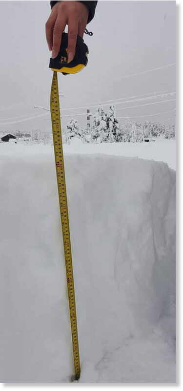
A member of Ulkatcho First Nation measures the snow on Friday, Nov. 27, 2020 showing that more than 60 cms of snow has fallen since a snowfall warning went into effect for northern portions of the Chilcotin on Thursday

A member of Ulkatcho First Nation measures the snow on Friday, Nov. 27, 2020 showing that more than 60 cms of snow has fallen since a snowfall warning went into effect for northern portions of the Chilcotin on Thursday
Graham West of Ulkatcho First Nation captures the scene on video

More than 60 cm of snow has fallen in parts of the Chilcotin since a snowfall warning went into effect Thursday, Nov. 26.

On Friday afternoon Graham West, a member of Ulkatcho First Nation near Anahim Lake, forwarded a photograph to the Tribune depicting a measuring tape with a snow level of 64 cm or two feet and one inch.

"Just got word the RCMP are on a snowmoblie with a nurse delivering meds to clients within the community," he said.

Earlier in the afternoon West said he hoped to get up on his roof to shovel because the snow was getting heavier.

"I believe my workout's gonna be interesting," he said.


A heavy snowfall in the Chilcotin overnight, as seen here at Ulkatcho First Nation near Anahim Lake on Friday, Nov. 27, has resulted in several downed power lines and the closure of some of Highway 20.
© Graham West

A heavy snowfall in the Chilcotin overnight, as seen here at Ulkatcho First Nation near Anahim Lake on Friday, Nov. 27, has resulted in several downed power lines and the closure of some of Highway 20.

Highway 20 is closed between Anahim Lake and Bella Coola and there is a travel advisory in effect between Anahim Lake and Tatlayoko Road.

The next update from DriveBC is expected at 4 p.m. about the highway conditions.

There are also 917 BC Hydro customers in the Bella Coola Valley without power due to down power lines as well as some customers in the Anahim Lake area, although West said he still has power.

(See video here)
 

TxGal

Day by day
Snowstorm (including thundersnow) hits island of Madeira -- Earth Changes -- Sott.net

Snowstorm (including thundersnow) hits island of Madeira

Jackson Groves
YouTube
Thu, 26 Nov 2020 12:26 UTC

snow

With snow reported the day before, we woke at 430am and drove as far up the mountain as possible. The roads were too icy to continue driving so we began hiking 10 kilometers below the summit of Pico do Arieiro a couple of hours before sunrise. In a crazy snowstorm, with frozen fingers and toes we reached the summit to see lightning strike the tower!
Can't believe it was snowing on Madeira!

View: https://youtu.be/i9Ie8vC1Ro8
 

TxGal

Day by day
We've finally been getting rainfall here, for the last few days now. First decent rain we've had since September, and this is our rainy season. Also been warm up until now. Next week gets interesting, with lows in the upper 20 and low 30s....every single night. Not much looking forward to that!
 

Windwood

Contributing Member
We've finally been getting rainfall here, for the last few days now. First decent rain we've had since September, and this is our rainy season. Also been warm up until now. Next week gets interesting, with lows in the upper 20 and low 30s....every single night. Not much looking forward to that!
We are also getting rain! The first substantial rain since Hurricane Delta. It is such a blessing. We have been so dry!!!
 

TxGal

Day by day
The Oppenheimer Ranch Project has a new podcast out:

Full Beaver Moon - Penumbral Eclipse - Snow way? Yes Way, Many Regions Will Receive Their First Snow - YouTube

Full Beaver Moon - Penumbral Eclipse - Snow way? Yes Way, Many Regions Will Receive Their First Snow
1,640 views • Premiered 8 hours ago

Run time is 14:06

Synopsis provided:

Louisville's first snow could fall early this week https://bit.ly/33rvu9J
Potent storm brings potential for measurable snow to Cincinnati https://bit.ly/3liyvzx
Snow showers move into Michiana Monday and Tuesday https://bit.ly/37gFMuH
First snow of the season could start Sunday night, bring 1-2 inches to Central Indiana https://bit.ly/3mm1hAr
Enough snow to have to 'move it around a bit' predicted for Tuesday and Wednesday in Buffalo https://bit.ly/36hygjN
Southeast Michigan to be 'clipped' by snowstorm Monday https://bit.ly/2J927Cs
GFS Model Total Snow US https://bit.ly/3miwaWh
Latest Picture Of The Sun https://sdo.gsfc.nasa.gov/assets/img/...
GOES X-RAY FLUX (DYNAMIC PLOT) https://bit.ly/30YhLGA
Worldwide Volcano News http://bit.ly/2v9JJhO Climate ‘apocalypse’ fears stopping people having children https://bit.ly/3o9hb1J
Biden COVID-19 adviser: Many who celebrated Thanksgiving with family or friends will be in ICUs over Christmas https://cbsn.ws/2JbcOEy
Here's how Earth looked to astronauts aboard the SpaceX capsule https://cnn.it/2VcDPKb
Victor Glovers Video From Space Of A Round Ball Called Earth https://bit.ly/33qKFQE
Full November ‘beaver moon’ and lunar eclipse to put on a sky show this wee
k https://bit.ly/3o7SK4O
 

Jubilee on Earth

Veteran Member
Some observations and musings: I had to come on here and talk about our winter so far. We are in northern Michigan at about the 45th parallel where winters are typically very cold and very snowy. I’ve lived in this area since 2011, and each year it started snowing at the end of October and didn’t let up until mid-April. Except for one year, winter of 2015/2016. That winter it didn’t snow until just after Christmas, but January and February made up for it. The Polar Vortex winter the year before that was ridiculously harsh.

This year, we are having another one of those mild starts. It only snowed once, about a week ago and it didn’t last even a day before it all melted. There’s a big winter storm coming into the Midwest on Tuesday, but we’re only forecasted to get an inch or two out of it. Then the temps go back up into the 40s, so it will also melt quickly. The forecast for the next 10 days is very mild and shows no potential for any other snowfall. I suspect we might have one of those strange “green Christmases” here in the mitten state.

I see all these articles about record breaking snow and cold, particularly in the east (India, Russia, etc). It really feels as if the jet stream has shifted, that it’s more than just a solar minimum and colder temps. If it were just that, then we’d be getting dumped on with lots of snow and cold blasts of air. But we’re not. Today is supposed to be a high of 50. That’s bizarre.

I haven’t read through this whole thread, but I came on here to hear your thoughts on this. Having spent last winter in Missouri and witnessed the scorching heat and droughts of the summer, I definitely feel like the microclimates of our country are changing. The Ozarks are now very much like Texas—lots of cactus, armadillos, snakes, scorpions, etc. It’s kinda nuts.

Your thoughts?
 

Windwood

Contributing Member
Some observations and musings: I had to come on here and talk about our winter so far. We are in northern Michigan at about the 45th parallel where winters are typically very cold and very snowy. I’ve lived in this area since 2011, and each year it started snowing at the end of October and didn’t let up until mid-April. Except for one year, winter of 2015/2016. That winter it didn’t snow until just after Christmas, but January and February made up for it. The Polar Vortex winter the year before that was ridiculously harsh.

This year, we are having another one of those mild starts. It only snowed once, about a week ago and it didn’t last even a day before it all melted. There’s a big winter storm coming into the Midwest on Tuesday, but we’re only forecasted to get an inch or two out of it. Then the temps go back up into the 40s, so it will also melt quickly. The forecast for the next 10 days is very mild and shows no potential for any other snowfall. I suspect we might have one of those strange “green Christmases” here in the mitten state.

I see all these articles about record breaking snow and cold, particularly in the east (India, Russia, etc). It really feels as if the jet stream has shifted, that it’s more than just a solar minimum and colder temps. If it were just that, then we’d be getting dumped on with lots of snow and cold blasts of air. But we’re not. Today is supposed to be a high of 50. That’s bizarre.

I haven’t read through this whole thread, but I came on here to hear your thoughts on this. Having spent last winter in Missouri and witnessed the scorching heat and droughts of the summer, I definitely feel like the microclimates of our country are changing. The Ozarks are now very much like Texas—lots of cactus, armadillos, snakes, scorpions, etc. It’s kinda nuts.

Your thoughts?
Hello! Yes, it has been unusually mild so far. I am in South West Louisiana. This year we had 2 devastating hurricanes ( there is still debris everywhere you look) and dry and hot weather after the hurricanes. We have just gotten our first substantial rain since Hurricane Delta. It has been so hot, as of yesterday we were still running the A/C. Our first freeze of the new season is due on Tuesday morning. Gotta get the plants moved to the greenhouse before then.

Usually down here we will get a cold snap but it doesn't last long and we're back to the air conditioning. This time it looks like we are going to stay with consistent highs in the 60's and lows in the 30's and 40's, so maybe, finally, we can turn off the A/C!
 

TxGal

Day by day
Adapt 2030 has a new podcast out:

Equatorial Eruptions, Electric Petroglyphs and Blizzards - YouTube

Equatorial Eruptions, Electric Petroglyphs and Blizzards
7,864 views • Nov 29, 2020

Run time is 7:01

Synopsis provided:

Myth and legend come to the skies as plasma ropes follow Earths magnetic field lines and higher voltage interact with atoms and parts of Jacobs Ladder come to life. Equatorial eruption to 50,000 feet Indonesia and a blizzard in the USA.
 

TxGal

Day by day
The Oppenheimer Ranch Project has a new podcast out:

Massive M4.4 Solar Flare & Coronal Mass Ejection - Solar Cycle 25 Is Ramping Up Quickly - YouTube

Massive M4.4 Solar Flare & Coronal Mass Ejection - Solar Cycle 25 Is Ramping Up Quickly
3,073 views • Premiered 12 hours ago

Run time is 3:18

Synopsis provided:

A Massive Solar Flare Just Kicked Off The Limb Of Our Sum . The M4.4 Solar Flare And Accompanying CME are not a threat to Earth but remind us of the possibilities to come.
GOES X-RAY FLUX (DYNAMIC PLOT) https://www.swpc.noaa.gov/products/go...
ISWA Spiral Plot https://iswa.gsfc.nasa.gov/IswaSystem...
Soho Movie Maker https://soho.nascom.nasa.gov/data/The...
 

TxGal

Day by day
Possible Impact following Massive M-4.4 Solar Flare/Coronal Mass Ejection - Electroverse

CME-image.jpg


POSSIBLE IMPACT FOLLOWING MASSIVE M-4.4 SOLAR FLARE/CORONAL MASS EJECTION
NOVEMBER 30, 2020 CAP ALLON

Yesterday (Nov. 29), Earth-orbiting satellites detected the biggest solar flare in more than 3 years.

NASA’s Solar Dynamics Observatory recorded the extreme-ultraviolet M-4.4 category blast, which was ejected off the eastern limb of the Sun:


NASA’s Solar Dynamics Observatory.

NOAA’s GOES X-Ray Flux confirmed the M-4.4 categorization:


NOAA’s GOES X-Ray Flux (1-minute data, 3-day) [swpc.noaa.gov].

X-rays and UV radiation from the flare ionized the top of Earth’s atmosphere, producing a shortwave radio blackout over the South Atlantic. Ham radio operators and mariners in the affected regions noticed strange propagation effects at frequencies below 20 MHz, with some transmissions below 10 MHz completely extinguished.

Remarkably, this flare was even bigger than it seems, writes Dr Tony Phillips from spaceweather.com. The blast site is located just behind the sun’s southeastern limb. As a result, the explosion was partially eclipsed by the body of the sun. It might even have been an X-class event.

The flare also hurled a significant coronal mass ejection (CME) into space, shown below in a coronagraph movie from SOHO (Solar and Heliospheric Observatory: a spacecraft built by a European industrial consortium led by Matra Marconi Space -now Airbus Defence and Space– and launched in 1995):


LASCO C3 [swpc.noaa.gov].

View: https://twitter.com/_SpaceWeather_/status/1333104825236598787


At first it appeared that the CME would completely miss Earth.

However, NOAA analysts now believe that the outskirts of the cloud could deliver a “glancing blow” to Earth’s magnetic field on Dec. 1-2 (maybe Dec. 3), as visualized in the screen-grab below–with Earth being the small yellow dot directly to the right of the larger, centrally-positioned Sun:

download-2.png

NOAA’s WSA-ENLIL PREDICTION [swpc.noaa.gov].

The impact will, at most, spark a minor G1-class geomagnetic storm with auroras over northern countries such as Canada, Iceland, Norway and Sweden likely. However, things could have played out very differently had the main body of the CME been Earth-bound. Then we would be anticipating a strong geomagnetic storm with the possibility of localized grid failure.

This coming CME is merely a warning shot of what to expect moving forward, any disturbances we see on Dec. 1-2 should be seen as a forewarning of what’s about to hit as Solar Cycle 25 continues its ramp-up. Next time we may not be so lucky. And “next time” could be just days away: the hidden sunspot that produced this major flaring event will rotate onto the Earth-facing solar disc during the next 24 hours-or-so. Eyes to the skies…

Prepare accordinglylearn the facts, relocate if need be, and grow your own.
 

TxGal

Day by day
Not good, this was another big one:

Indonesia's Lewotolo Volcano Erupts to 50,000 Feet (15.2 km) - Global Cooling - Electroverse

lewotolo-Nov-29-e1606733123457.jpg


INDONESIA’S LEWOTOLO VOLCANO ERUPTS TO 50,000 FEET (15.2 KM) — GLOBAL COOLING
NOVEMBER 30, 2020 CAP ALLON

A high-level eruption took place at the symmetrical stratovolcano “Lewotolo” at 01:50 UTC on November 29, located on Lembata Island, Indonesia.

According to the Darwin VAAC, a thick volcanic ash cloud was discernible on satellite imagery (Himawari-8, Copernicus Sentinel-2) rising to maximum altitude of 50,000 feet (15.2 km).

As a result, the Aviation Color Code was raised to Red.

View: https://twitter.com/defis_eu/status/1332986550976716805


Particulates ejected to altitudes above 32,800 feet (10 km) –and so into the stratosphere– often linger and can have a direct cooling effect on the planet.

View: https://twitter.com/disclosetv/status/1333022146742902786


The Center for Volcanology and Geological Hazard Mitigation (CVGHM) has advised that an area with a radius of 1.2 miles (2 km) around the summit of the volcano be evacuated.

View: https://twitter.com/Dhan_17atan/status/1332955858330796032


View: https://twitter.com/sxrahaguiar/status/1333231370932457473


The Indonesian National Board for Disaster Management (BNPB) is still coordinating with relevant authorities to assess the impact of the eruption — however, initial indications reveal that an estimated 487,833 people are exposed to the hazard, with USD$1.38 Billion of infrastructure at risk.

According to CVGHM, Lewotolok has been in Alert Level II status since Oct. 7, 2017 following a significant increase in seismicity, especially local tectonic earthquakes, deep volcanic and shallow volcanic since mid-Sept. 2017.

Before that though, there had been little to no seismic activity since 2012.

Finally, last Thursday, on Nov. 26, 2020 Lewotolo awoke, sending a small but dense gray-black ash plume to 1,640 feet (500 m).

View: https://twitter.com/volcanohawk/status/1332108114292731904


BACKGROUND

Stratovolcano: 1423 m / 4,669 ft
Central Java, Indonesia: -8.27°S / 123.51°E
Current status: ERUPTING (4 out of 5)
Lewotolo (or Ile Api Lewotolok) is located on the eastern end of a peninsula of Lembata (formerly Lomblen) Island, and forms a perfect symmetrical cone.

Historical eruptions, recorded since 1660, have consisted of explosive activity from the summit crater.
For more see volcano.si.edu.
Full Eruption list: 2012, 1951, 1920, 1899, 1864, 1852, 1849, 1819, 1660
For more see volcanodiscovery.com.

UPTICK

Seismic and Volcanic activity has been correlated to changes in our sun.
The recent global uptick in earthquakes and volcanic eruptions is likely attributed to the drop-off in solar activity, coronal holes, a waning magnetosphere, and the influx of Cosmic Rays penetrating silica-rich magma.
Check out these link for more info:

https://principia-scientific.org

https://www.researchgate.net

Prepare accordinglylearn the facts, relocate if need be, and grow your own.
 

TxGal

Day by day
Jaw-dropping Snowfall buries Towns and Cities across Krasnoyarskiy Kray, Russia - Electroverse

Nor-4-1-e1606736726343.jpg


JAW-DROPPING SNOWFALL BURIES TOWNS AND CITIES ACROSS KRASNOYARSKIY KRAY, RUSSIA
NOVEMBER 30, 2020 CAP ALLON

An incredible amount of snow encased Russia’s central federal subject of Krasnoyarskiy Kray (Krai) in an icy tomb Sunday, November 29.

“Mountains of snow” were reported in towns and cities across the vast Siberian district, including in its administrative center of Krasnoyarsk.

The below 2:28 minute report from START on YouTube sums up the scenes:

View: https://youtu.be/Xz6xxl2Bz_k


The below footage comes from Nature News on YouTube.

It was shot in Talnakh (aka Norilsk) –a small town located at the foot of the Putoran Mountains in Taymyr Peninsula, Krasnoyarsk Kray– and shows cars, and in some cases even buildings, buried under 10-foot+ drifts:

View: https://youtu.be/x-3ov9e_CqA


Next is a video posted by Norilsk local olga_zapsever on Instagram:

Instagram video by Ольга • Nov 28, 2020 at 4:40 AM

And finally, below are four additional images of Norilsk’s Sunday snowstorm, courtesy of a gallery created by @WeatherSarov1 on Twitter:

1606744088599.png


1606744123644.png

1606743870601.png

1606743895046.png


The MSM were all-too keen to report on Russia’s anomalous summer heat earlier in the year. Well, now let’s put that “impartiality” they routinely brag about to the test — let’s see if they document the transcontinental nation’s truly jaw-dropping, early-season, and no doubt record-breaking snowfall.

View: https://twitter.com/forumatmosfer/status/1333142608978341895


The COLD TIMES are returning, the mid-latitudes are REFREEZING in line with historically low solar activity, cloud-nucleating Cosmic Rays, and a meridional jet stream flow.

Both NOAA and NASA appear to agree, if you read between the lines, with NOAA saying we’re entering a ‘full-blown’ Grand Solar Minimum in the late-2020s, and NASA seeing this upcoming solar cycle (25) as “the weakest of the past 200 years”, with the agency correlating previous solar shutdowns to prolonged periods of global cooling here.

Furthermore, we can’t ignore the slew of new scientific papers stating the immense impact The Beaufort Gyre could have on the Gulf Stream, and therefore the climate overall.


Prepare accordinglylearn the facts, relocate if need be, and grow your own.
 

packyderms_wife

Neither here nor there.

Martinhouse

Deceased
Got up at 7:00 this morning. Computer said it was 19 degrees in my area. My backyard thermometer said 23. No idea what it may have been earlier.

Sure am glad I got my little heater set up last night! It felt warmer when I stepped into the kitchen from the back porch where I feed my cat. Up until the last few days, it's been warmer outdoors than it's been in my house.

I HATE WINTER!!!!!
 
Top