Solar Grand Solar Minimum part deux

TxGal

Day by day

OK-ice-storm-e1603877676466.jpg


EARLIEST OKLAHOMA ICE STORM IN RECORDED HISTORY LEAVES 300,000 WITHOUT POWER
OCTOBER 28, 2020 CAP ALLON

A rare and dangerous ICE STORM is continuing Wednesday, October 28 in Oklahoma — a storm that, so far, has knocked out the power to 300,000.

Widespread damage and disruption has been reported across the South Central state of Oklahoma, mostly the result of frozen tree limbs buckling under the weight of accreting ice and bringing down power-lines.

Social media has been packed with the incredible scenes this week:

View: https://twitter.com/KOCOMichael/status/1320912729075601408


View: https://twitter.com/live2chase/status/1321227907172306952


It was the first time that the National Weather Service (NWS) issued an ice storm warning in the month of October in OK, and, as reported by the WP, “the pre-Halloween glaze was the worst ice storm to strike at any time of year in at least five years.”

View: https://twitter.com/burgwx/status/1321130572232740864


View: https://twitter.com/BraydenSiau/status/1321228410979495937


View: https://twitter.com/Tornado_Steejo/status/1321123565559795713


Oklahoma City Memorial and Oklahoma Forestry Services crews were scrambling to save the “Survivor Tree,” an American elm at the Oklahoma City National Memorial. The monument honors the 168 people who lost their lives at the Alfred P. Murrah Federal Building in a terrorist bombing on April 19, 1995.

“We lost a branch but have propped up others to save them,” wrote the Oklahoma City National Memorial and Museum on Facebook. “We will continue to monitor it 24/7 throughout this historic storm.”

View: https://twitter.com/KOCOZach/status/1321119912077758469


According to the forecasts, another half-inch of freezing rain –rain that freezes on contact with the surface– is possible Wednesday. A period of heavy snow is even possible late Wednesday into Thursday, with neighboring Texas and New Mexico also set for additional record setting flurries.

According to the forecasts, another half-inch of freezing rain –rain that freezes on contact with the surface– is possible Wednesday. A period of heavy snow is even possible late Wednesday into Thursday, with neighboring Texas and New Mexico also set for additional record setting flurries.


GFS Total Snowfall (inches) for Oct, 28 – Oct 29 [tropicaltidbits.com].

This continent spanning “winter” storm has been truly historic.

Hundreds upon hundreds of cold records have been toppled over the past few days, including a “biggie” — on Sunday, the United States set its coldest temperature ever recorded this early in the season:


And it ain’t over yet.

Latest GFS forecasts see the Arctic cold lingering across the majority of North America for the remainder of the week. Then, the models suggest another round of polar air will engulf the eastern half of the continent during the first few days of November. Looking even further ahead, and admittedly into the unreliable time-frame, the GFS sees a third mass of brutal Arctic air –one to rival the first– hitting North America by November 10th:


gfs_T2ma_namer_56.png

GFS 2m Temp Anomalies (C) Nov 10 [tropicaltidbits.com].

Everything that we are witnessing, from a “warming” Arctic to the refreezing of the mid-latitudes, can be fully explained by a Grand Solar Minimum.

The COLD TIMES are returning in line with historically low solar activity, cloud-nucleating Cosmic Rays, and a meridional jet stream flow.

Both NOAA and NASA appear to agree, if you read between the lines, with NOAA saying we’re entering a ‘full-blown’ Grand Solar Minimum in the late-2020s, and NASA seeing this upcoming solar cycle (25) as “the weakest of the past 200 years”, with the agency correlating previous solar shutdowns to prolonged periods of global cooling here.

Furthermore, we can’t ignore the slew of new scientific papers stating the immense impact The Beaufort Gyre could have on the Gulf Stream, and therefore the climate overall.


Prepare accordinglylearn the facts, relocate if need be, and grow your own.
 

TxGal

Day by day

Rare October ice storm hits Oklahoma, knocks out power to 300,000

Matthew Cappucci
Washington Post
Tue, 27 Oct 2020 18:22 UTC

Icicles hang from power lines and poles Tuesday in Oklahoma City
© Brad Carl
Icicles hang from power lines and poles Tuesday in Oklahoma City.

A disruptive and dangerous ice storm is underway in Oklahoma, with ice storm warnings plastering the map and more than 300,000 people without power. "Tree carnage" has been reported in Oklahoma City, where vegetation and power lines have been collapsing beneath the weight of the accreting rime. Up to another half-inch of freezing rain — rain that freezes on contact with the surface — is possible as more waves move through the affected regions into Wednesday.

The University of Oklahoma warned students of "lightning-infested sleet and freezing rain storms" that would hit the central Oklahoma campus, with thunder echoing throughout Oklahoma City. Social media was replete with photos of toppled trees, the storm posing a particular danger to agriculture.

It was the first time that the National Weather Service in either Norman or Tulsa had issued an ice storm warning during the month of October, and the pre-Halloween glaze was the worst ice storm to strike at any time of year in at least five years.

View: https://youtu.be/MyVVpM2lfNA


View: https://youtu.be/1yIz4pm0tnE


At least an inch of ice had already accreted on surfaces by early afternoon just west of Oklahoma City in the town of El Reno.

Oklahoma City Memorial and Oklahoma Forestry Services crews were scrambling to save the "Survivor Tree," an American elm at the Oklahoma City National Memorial. The monument honors the 168 people who lost their lives at the Alfred P. Murrah Federal Building in a terrorist bombing on April 19, 1995.

"We lost a branch but have propped up others to save them," wrote the Oklahoma City National Memorial and Museum on Facebook. "We will continue to monitor it 24/7 throughout this historic storm."

One of the heaviest bands of freezing rain was working northeast along Interstate 44 in southwest Oklahoma midmorning Tuesday, riding along the heavily traveled H.E. Bailey Turnpike. The Oklahoma Department of Transportation reported "severe" travel hazards, stating: "Driving in these conditions can be dangerous. Please avoid driving if possible."

In Stephens County, just east of Lawton-Fort Sill, commercial vehicles were restricted from Highway 81 between Marlow and Duncan because of power lines hanging low over the roadway. Numerous house fires occurred Monday, many a result of downed wires.

Interstate 40 eastbound was narrowed to one lane in Gore, near the Arkansas border, because of a crash.

Emergency management also reported trees blocking the eastbound lanes of Southwest 119th Street in Moore, a suburb just south of Oklahoma City.

Some residents took to social media to voice their experiences weathering the storm. One Twitter user wrote that their father, age 55, fell and fractured a vertebrae while trimming a tree coated in ice in Oklahoma City.

View: https://twitter.com/KOCOMichael/status/1320912729075601408


"So many tree limbs popping, pulverizing our power lines," wrote another.

Numerous school and extracurricular program closings were reported across the state, with some classes canceled entirely while others were moved online for virtual instruction.

"It's been years since [Oklahoma City] has had to deal with a significant winter weather event," wrote Brad Carl, a former Tulsa television meteorologist who now works for the Nature Conservancy in Oklahoma City. "I think this ice storm has painfully reminded us that winter can be wicked around these parts when it really wants to be."

View: https://twitter.com/Tornado_Steejo/status/1321123565559795713


Carl said he experienced flickering lights throughout the day Monday, finally losing power like tens of thousands of others in the city limits early Tuesday morning. He captured images of iced-over leaves and branches, and icicles hanging from power lines like stalactites.

The time of year, when trees are still fully-leafed and vegetation is somewhat verdant, means the ice event is even more disruptive, since there is greater surface area on trees where ice can accrete. That allows more weight to build up, making it easier for limbs and branches to collapse.

The cause of the ice storm is a narrow layer of cold air at the surface below a mile in altitude. At 7,800 feet, it was nearly 47 degrees Tuesday morning over Oklahoma City, yet temperatures at ground level have remained below freezing since midmorning Monday. That permits liquidwater to fall and hit the ground, quickly freezing on contact.

In the warmer air at the mid-levels, periodic surges of moisture have brought repeated rounds of moderate precipitation, with some sleet mixing in at times. That's cut back on freezing rain totals in a few spots but made for more difficult travel.

Overnight temperatures will warm just above freezing, allowing the final bout of precipitation Wednesday — perhaps the heaviest — to fall as rain. A period of heavy snow is even possible with moisture wrapping around the low-pressure system late Wednesday into Thursday in West Texas and the Texas Panhandle.

Highs across central Oklahoma will rebound into the 60s by the weekend, leaving residents to clean up the mess in more comfortable conditions.

Comment: See also:
 

BenIan

Veteran Member
Adapt 2030 has a new podcast out:

View: https://www.youtube.com/watch?v=3cTrqLLKXT4


Apocalyptic Ice Storm Slams Into Hurricane Zeta
28,931 views • Premiered 9 hours ago

Run time is 17:22

Synopsis provided:

With the coldest October temperatures ever recorded in any year smashing thousands of historic all time cold records back to 1879, winter storm Betty is now colliding with the incoming front of Hurricane Zeta. Ice accumulations are forecast up to 1.5 inches in areas across the Midwest USA.
I've got Zeta coming in just east of me and this Arctic front coming in from the west. Will be interesting to see how they interact.
 

summerthyme

Administrator
_______________
I've got Zeta coming in just east of me and this Arctic front coming in from the west. Will be interesting to see how they interact.
Do you have a storm shelter? It seems this combo could spawn some serious tornados! Stay safe down there... that ice storm is awful!

Summerthyme
 

TxGal

Day by day
I've got Zeta coming in just east of me and this Arctic front coming in from the west. Will be interesting to see how they interact.
Oh my...it looks like this Arctic front is what's keeping Zeta off the Houston area. We're hovering at 40 up here now with wind chills in the 30s and light rain. Just got back inside from taking care of the poultry and our hands are red from the cold.

It's too early for this here!
 

TxGal

Day by day

Record snow and ice in the U.S.
October 28, 2020 by Robert

No precedent in either Tulsa or Oklahoma City for an ice storm warning in October. Beats out the previous earliest issuance by six weeks. Amarillo could see record snowfall.

___________

26 Oct 2020 – Accompanying the recent record cold, heavy snow plastered parts of the High Plains and Rockies. Denver picked up just under three inches of snow. Boulder wound up with more than a foot.

Missoula logged its eighth-biggest snowstorm on record, with a hefty 13.8 inches in just two days.

Farther south, almost the entire state of New Mexico was under a winter storm warning Monday, with heavy snow of half a foot or more likely in most areas. Higher elevations in the mountains could see 12 to 18 inches.

Amarillo could see record snowfall

Thundersnow was reported across the Texas Panhandle on Monday morning with more on the way. Four to 10 inches could fall Tuesday into Wednesday. That may break the October record for Amarillo’s snowiest calendar day, which stands at 5.5 inches.

Wichita – Heaviest snow ever so early in the season

The snow came sweeping down the Plains, too. Wichita had accumulated 1.3 inches by lunchtime Monday, the heaviest snow it has experienced so early in a season. Every county in the state was under a winter weather advisory, a combination of snow, sleet and freezing rain making for slick travel.

Winter storm and ice storm warnings for most of Colorado, New Mexico, Texas Panhandle and Oklahoma

Winter storm and ice storm warnings were up for most of Colorado, New Mexico, the Texas Panhandle and Oklahoma, while winter weather advisories stretched northeast into Kansas City toward the Iowa border.

Meanwhile, much of central Oklahoma was under an ice storm warning, including the I-35 corridor north of Oklahoma City. Some parts of the state could see a half-inch to an inch of ice accretion by Wednesday.

No precedent in either Tulsa or Oklahoma City for an ice storm warning in October

It’s exceptionally early in the season to see an episode like this; in fact, there is no precedent for the Weather Service offices in either Tulsa or Oklahoma City issuing an ice storm warning in October. The warning issued Monday morning by the Tulsa office beats out the previous earliest issuance by six weeks.

Oklahoma City, Lawton-Fort Sill, Okla., and Wichita Falls, Tex., — all home to roughly 100,000 people or more — could see a half-inch to an inch of ice, making this a high-impact event. For some, the freezing rain could mix with or change to sleet for a time, which would limit ice accumulations on trees and power lines.

https://www.washingtonpost.com/weather/2020/10/26/snow-ice-storm-plains-rockies/
 

TxGal

Day by day

Coldest temperature ever recorded this early in the season in the “Lower 48”
October 28, 2020 by Robert

Temperatures plunged to minus-29.2 in Potomac, Montana, early Sunday — the coldest temperature ever observed this early in the season across the contiguous United
States (the “Lower-48”).

The U.S. historical temperature database contains 14.5 million observations from Oct 1 to Oct 25, and Potomac’s reading on Sunday morning was the coldest!

Hundreds of new low temperature records have been set over the past few days alone, but all have been eclipsed by Montana’s “biggie.”

Hundreds of cold and snow records have also fallen of late: from Texas to Montana, many of the lowest temperatures and the highest snowfall totals ever recorded at this time of year are not only being broken, they’re being smashed.

A few examples:

The National Weather Service reported two broken snowfall records at their Marquette office: “We recorded 8.3 inches [on Sunday], which breaks the old record of 3.1 inches set in 1976 [solar minimum of cycle 20]! This recent snowfall also established a new monthly snowfall record for the month of October at our office. Total snowfall recorded for the month stands at 19.2 inches! This breaks the old record of 18.6 inches set in 1979.”

Eastern Idahoans woke to bone-chilling weather Monday morning, reports eastidahonews.com. According to NWS data, Idaho Falls saw a low of just 1F, utterly shattering the previous record of 17F. In addition, Pocatello reached 3F, smashing its previous record low of 13F. The previous day, Sunday, also saw new record lows of 8 degrees in Idaho falls and 11 degrees in Pocatello.

Brrr!!! Eastern Idaho sets record low temperatures Monday - East Idaho News
 

TxGal

Day by day

snow-Hawaii-Oct-2020-e1603885156210.jpg


OCTOBER SNOW IS FALLING IN HAWAII
OCTOBER 28, 2020 CAP ALLON

For many, October, 2020 has been one of the longest and “wintriest” Octobers in a very long time — further signs that the Grand Solar Minimum is upon us.

Benchmarks for both cold and snow across the Northern Hemisphere are not only being broken, the are being obliterated — as National Weather Service meteorologist Corby Dickerson says: “It’s not normal to set this many records in this short of a time – and monumental records.”

While cool, wet and unstable weather brought thunderstorms and heavy rain to the western half of Hawaii this week, conditions conspired to deliver a dusting of snow to the tropical island state’s mountains.

View: https://twitter.com/danielmoser/status/1320944177396342785


Atop Mauna Kea, cameras at the Weather Center captured a blanket of October snow at 4 p.m. on Monday, Oct 26 — an incredibly rare sight this early in the season, and even rarer still is that the powder has stuck around, with further flurries falling Tuesday:

View: https://twitter.com/KITV4/status/1321198767492780033


According to Ken Rubin, professor at the Department of Geology and Geophysics University of Hawaii, Honolulu, this is indeed a rare event. He says that the highest peaks only get “dusted with snow a few times a year, [but that] it rarely stays on the ground for more than a few days”.

As reported by hawaiinewsnow.com, the Mauna Kea Visitor Information Station said the unusually snowy conditions lead to the closure of the mountain’s main road from Monday.

View: https://twitter.com/HawaiiNewsNow/status/1321004065074094080


Looking ahead, even more snow is likely to fall over the coming days as weather systems converge with near-freezing temperatures.

Buckle up folks, and don’t say you weren’t warned — the winter of 2020-21 across the northern hemisphere is shaping up to be something of a doozy.

The COLD TIMES are returning, the mid-latitudes are REFREEZING in line with historically low solar activity, cloud-nucleating Cosmic Rays, and a meridional jet stream flow.

Both NOAA and NASA appear to agree, if you read between the lines, with NOAA saying we’re entering a ‘full-blown’ Grand Solar Minimum in the late-2020s, and NASA seeing this upcoming solar cycle (25) as “the weakest of the past 200 years”, with the agency correlating previous solar shutdowns to prolonged periods of global cooling here.

Furthermore, we can’t ignore the slew of new scientific papers stating the immense impact The Beaufort Gyre could have on the Gulf Stream, and therefore the climate overall.


Prepare accordinglylearn the facts, relocate if need be, and grow your own.
 

TxGal

Day by day

US corn crops are becoming increasingly sensitive to drought

Stanford University
Phys.org
Wed, 28 Oct 2020 11:05 UTC

corn
© Pixabay/CC0 Public Domain

Like a baseball slugger whose home run totals rise despite missing more curveballs each season, the U.S. Corn Belt's prodigious output conceals a growing vulnerability. A new Stanford study reveals that while yields have increased overall — likely due to new technologies and management approaches — the staple crop has become significantly more sensitive to drought conditions. The research, published Oct. 26 in Nature Food, uses a novel approach based on wide differences in the moisture-holding capabilities among soils. The analysis could help lay the groundwork for speeding development of approaches to increase agricultural resilience to climate change.

"The good news is that new technologies are really helping to raise yields, in all types of weather conditions," said study lead author David Lobell, the Gloria and Richard Kushel Director of the Center on Food Security and the Environment. "The bad news is that these technologies, which include some specifically designed to withstand drought, are so helpful in good conditions that the cost of bad conditions are rising. So there's no sign yet that they will help reduce the cost of climate change."

Comment: Yield is one thing, quality of product is another. YouTuber Ice Age farmer has reported that numerous farmers are also documenting increasingly poor quality yields that are only good for animal fodder, meaning less product available for consumers. Also bear in mind that what an animal eats will impact the nutritional quality of its meat and, in turn, will lead to a deterioration in the health of the consumer.

Corn production in the U.S. is a seemingly unstoppable juggernaut. Despite concerns about resistant weeds, climate change and many other factors, the industry has set record yields in five of the last seven years. Likely drivers of these bumper crops include changes in planting and harvesting practices, such as adoption of drought-tolerant varieties, and changes in environmental conditions, such as reduced ozone levels and increased atmospheric carbon dioxide concentrations that generally improve the water-use efficiency of crops.

Comment: Note increased CO2 should lead to an increase in crop health.

As climate change intensifies, however, the cost to maintain crop yields will likely increase.

Using county soil maps and satellite-based yield estimates, among other data, the researchers examined fields in the Corn Belt, a nine-state region of the Midwest that accounts for about two-thirds of U.S. corn production. By comparing fields along gradients of drought stress each year, they could identify how sensitivity to drought is changing over time.

View: https://youtu.be/yyiet37xrSk


Even within a single county, they found a wide range of soil moisture retention, with some soils able to hold twice as much water as others. As might be expected, there were generally higher yields for soils that held more water. They found yield sensitivity to soil water storage in the region increased by 55 percent on average between 1999 and 2018, with larger increases in drier states.

The results made clear soil's ability to hold water was the primary reason for yield loss. In some cases, soil's ability to hold an increased amount of moisture was three times more effective at increasing yields than an equivalent increase in precipitation.


So, why have yields become more sensitive to drought? A variety of factors, such as increased crop water needs due to increased plant sowing density may be at play. What is clear is that despite robust corn yields, the cost of drought and global demand for corn are rising simultaneously.

Comment: It's likely that a combination of shifts in the climate as well harmful farming practices that destroy the biology of the soil, that, crucially, helps retain moisture, are all contributing to increased stress and loss in crop harvests. And it's not only droughts and flooding that are causing crop losses, but early frosts too.

To better understand how climate impacts to corn are evolving over time, the researchers call for increased access to field-level yield data that are measured independently of weather data, such as government insurance data that were previously available to the public but no longer are.

"This study shows the power of satellite data, and if needed we can try to track things from space alone. That's exciting," Lobell said. "But knowing if farmers are adapting well to climate stress, and which practices are most helpful, are key questions for our nation. In today's world there's really no good reason that researchers shouldn't have access to all the best available data to answer these questions."

Lobell is also a professor of Earth System Science in Stanford's School of Earth, Energy & Environmental Sciences; the William Wrigley Senior Fellow at the Stanford Woods Institute for the Environment and a senior fellow at the Freeman Spogli Institute for International Studies and the Stanford Institute for Economic Policy Research. Study co-authors include Jillian Deines, a postdoctoral research fellow in Stanford's School of Earth, Energy & Environmental Sciences, and Stefania Di Tommaso, a research data analyst at the Center on Food Security and the Environment.

More information: Changes in the drought sensitivity of US maize yields, Nature Food (2020). DOI: 10.1038/s43016-020-00165-w , www.nature.com/articles/s43016-020-00165-w Journal information: Nature Food
 

TxGal

Day by day

Historic hurricane and ice storm warnings simultaneously in effect across the southern US

Marko Korosec
Sever Weather Europe
Tue, 27 Oct 2020 16:32 UTC

Hurricane Zeta

A catastrophic ice storm with destructive freezing rain is now underway across northwestern Texas and west-central Oklahoma. While at the same time, Tropical Storm Zeta is emerging back to the Gulf of Mexico after a damaging landfall as a hurricane in the Yucatan peninsula, Mexico last night. It will re-strengthen into a hurricane and head for the Gulf Coast on Wednesday.
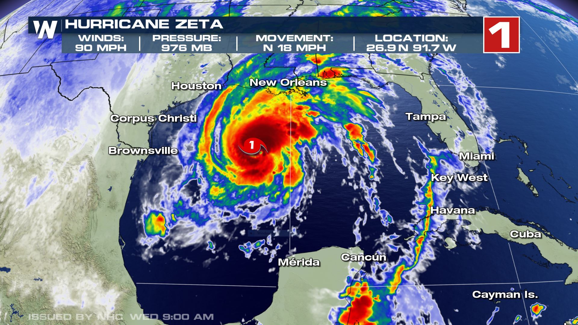
Hurricane Zeta

Hurricane Zeta, the 6th Greek alphabet named storm of Atlantic hurricane season 2020, has made landfall near the city of Consumel, Mexico last night, Oct 26th late evening. The landfall was of a Category 1 strength.

Now, Zeta is soon emerging into the Gulf of Mexico and will re-strengthen into a hurricane and head towards another dangerous landfall at the central Gulf Coast tomorrow.

The same hurricane Delta did two weeks ago. Delta crossed the northern tip of the Yucatan peninsula and made its second landfall in Louisiana a few days later.

Hurricane Warning
A Hurricane Warning is in effect for the coastal areas of southern Louisiana, Mississippi, and Louisiana.

A Hurricane Warning is in effect for the coastal areas of southern Louisiana, Mississippi, and Louisiana.

Ice Storm in northwest Texas and Oklahoma

As we discussed last night, a historic and record-breaking early season Arctic outbreak has penetrated deep south into the southern United States. The core of the Arctic trough has developed a new surface low which is resulting in a catastrophic ice storm across northwest Texas and west-central Oklahoma.

Ice storm damage
© Photo by: Mateusz Taszarek
Ice storm damage in Norman, Oklahoma.

A massive amount of freezing rain is expected on Tuesday, with widespread tree damage and power outages already reported from parts of Oklahoma and Texas. Heavy rainfall is occurring with subfreezing surface temperature, so ice accumulation is rapidly increasing.

The dangerous winter storm continues, with additional freezing rain and sleet expected through portions of western north Texas and Oklahoma. The Ice Storm Warning continues through Wednesday morning.

And in addition, the Oklahoma City area is under a record-breaking warning - the earliest ice storm warning ever issued.

ice storm warning

A combination of both, the tropical and winter events, is creating a unique Hurricane Warning versus Ice Storm Warning event across the Southern Plains/Gulf Coast domain.

Both areas under different warning hazards, hurricane warnings, and ice storm warnings are separated by *only* around 400 miles (650 km). This has never happened before.

An ongoing ice storm across Oklahoma and Texas while hurricane Zeta is emerging over the Gulf of Mexico and heading for a landfall in Louisiana tomorrow.

The only other time that a *winter* and a *tropical* warnings could have been in close proximity was with hurricane Sandy in 2012, while the Winter Storm Warning was in effect across western Virginia. But the winter warning was far less prominent than the ongoing event in Texas and Oklahoma.

Hurricane Sandy had its landfall point in New Jersey and it was separated by the swath of intense snowfall in West Virginia. The distance between the events was roughly 350 miles (500 kilometers).

The snowfall event was actually produced by outer bands of Hurricane Sandy.

snowfall

However, Sandy was transitioning to post-tropical storm at that time and as such, the National Hurricane Center (NHC) had discontinued all 'tropical' warnings for the system north of the North Carolina coast. Therefore, although it is the closest idea to the current situation, these events wouldn't fit.

This means the late October Ice Storm Warning across northwestern Texas and west-central Oklahoma versus the hurricane warning in Louisiana are creating a unique and historic event that has never happened before.

It looks like this could be THE year, seriously.

The global Covid-19 pandemic ... a record-breaking Atlantic hurricane season with 10+ United States mainland landfalls ... a historic early season Arctic outbreak with a catastrophic ice storm across the Southern Plains of the United States ... the Arctic sea ice is not freezing In October for the first time since records began ... The worst wildfires across the United States, Siberia ...


What else ... ? Wait, did someone say 2020?!

ICE STORM CONTINUES UNTIL WEDNESDAY MORNING

While additional deep snow is forecast for areas across New Mexico, the Panhandles, and Kansas, the biggest concern is now a very significant impact of freezing rain* with a major ice storm forecast for parts of Texas and Oklahoma until Wednesday.

Ice storms and freezing rain (black ice) are extremely dangerous and damaging during the winter months, but right now it is still only October and most of the trees still have their leaves.

Numerous residential structures could lose electricity for days. To keep in mind that the power lines could break under the weight of the ice alone, even without overhead tree branches crashing down.

*Freezing rain forms when a layer of warm air aloft is placed above a layer of below-freezing (subfreezing) air at the surface. Snowflakes that falling towards the ground, melt as they fall through this warm layer. If the flakes are completely melted, then it is falling as rain towards the ground which is much colder. This liquid droplet then freeze on contact with exposed surfaces

The second round of wintry precipitation has begun across the western portions of Texas and Oklahoma overnight to Tuesday and is now intensifying. The precipitation are also increasing coverage.

There has already been a lot of tree damage and power outages reported, while the greatest amount of snow and ice accumulations in this ice storm event are expected through Tuesday afternoon and evening hours.

Temperatures remain below freezing across the western half of Oklahoma.

Here is the Skew-T (sounding temperature vertical cross-section diagram) for Norman, Oklahoma City (central Oklahoma) at 00 UTC Tuesday. It is revealing an exceptionally deep warm layer placed above the much colder, subfreezing near-surface layers.

Skew-T Oklahoma City

There are temperatures of nearly 13 degrees Celsius (33 degrees F) warmer at 2500 meters above the ground than those at around 1000 meters above the ground. Temperatures are below freezing up to around 1300 meters.

Above freezing temperatures are seen across the layer from 1300 to 3600 meters (approx. 4200 to 11800 feet) above the ground.

Notice there is also strong southwesterly wind aloft, helping to transport high moisture into the region.

The event will continue to produce widespread catastrophic tree damage from northwest Texas into west-southwest and central Oklahoma on Tuesday into early Wednesday. It will also cause power line destruction with numerous power outages as tree branches will be crashing down the powerlines.

The weight of ice accumulating will be significant with this ice storm, especially on trees that still have leaves.

Here is the early Tuesday weather forecast for the total amount of freezing rain by the Pivotalweather model HRRR. A broad corridor of thick ice accumulation is spread across northwest Texas and west, southwest, and central Oklahoma.

weather forecast texas

Some areas could see between 1 and 1.5″ (2.5-4 cm) of freezing rain (black ice*) accumulation by Wednesday morning. The event is becoming historic for October this far south in the United States. But it is also extremely destructive.

The snowy and icy conditions will lead to significant travel hazards across the west north Texas and most of Oklahoma. Be extremely cautious about the rapidly worsening conditions today and through Tuesday night into early Wednesday.

Further west, a swath of impressively high snowfall accumulation remains forecast across northern New Mexico. Additional 10-15 inches (25-40 cm) is forecast by the latest HRRR model.

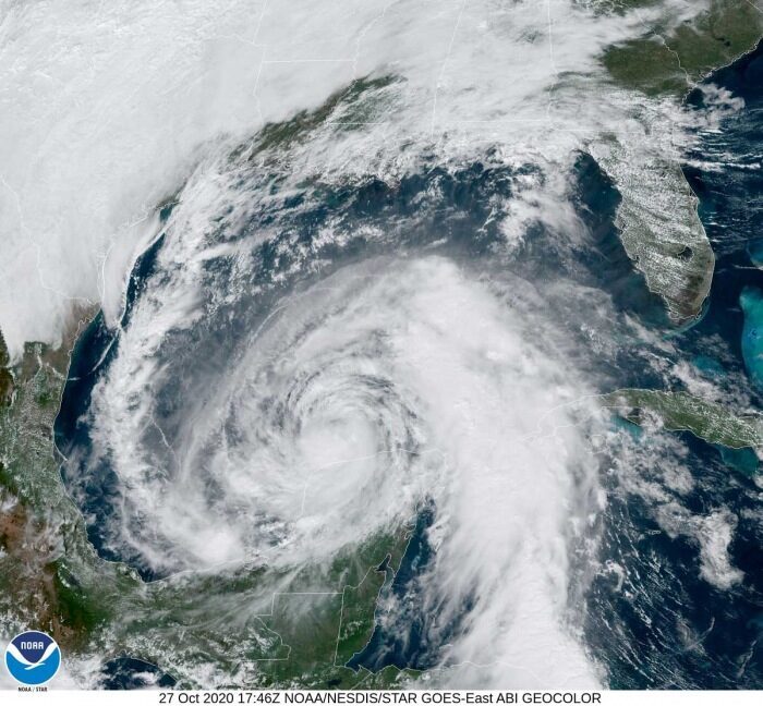
ZETA ON THE WAY FOR HURRICANE LANDFALL AT THE GULF COAST

*Latest on Hurricane Zeta: New storms exploding over the Gulf of Mexico, life-threatening landfall is now expected near New Orleans on Wednesday*

According to the National Hurricane Center (NHC), there is a life-threatening storm surge is expected along portions of the northern Gulf Coast by late Wednesday, with the highest inundation occurring somewhere between the Mouth of the Pearl River and Dauphin Island, Alabama. Residents in the Storm Surge Warning area should follow any advice given by local officials.

Zeta is expected to re-intensify over the southern Gulf of Mexico tonight as its structure comes over the still-warm Gulf of Mexico completely. There are still close to 29 °C seawater temperatures across the southern portions of the Gulf, gradually cooler towards the Gulf Coast of the United States.

hurricane warning
A Hurricane Warning is in effect for the coastal areas of southern Louisiana, Mississippi, and Louisiana.

Hurricane conditions are expected by late Wednesday within portions of the Hurricane Warning area between Morgan City, Louisiana, and the Mississippi/Alabama border. Damaging winds, especially in gusts, will spread well inland across portions of southeast Mississippi and southern Alabama Wednesday night due to Zeta's fast forward speed.

tropical storm winds

Tropical storm conditions will continue in portions of the northern Yucatan Peninsula of Mexico during the next few hours. Heavy rainfall is expected across the Yucatan Peninsula, the Cayman Islands, and western Cuba today, which will lead to flash flooding in urban areas.

According to Philip Klotzbach, Hurricane Zeta has made landfall in the Mexican state of Quintana Roo as a Category 1 hurricane. This set a new record as it was the 3rd named storm to make landfall in Quintana Roo this month (Gamma and Delta were the other two). The previous record for October Quintana Roo named storm landfalls was two, set in 1887 and 2005.

Zeta is forecast to be near hurricane strength again prior to making landfall tomorrow (Wednesday) along the northern Gulf Coast. Potentially in southern Louisiana, very near New Orleans.

If Zeta indeed makes landfall as a hurricane, it would be the latest calendar year hurricane to hit the continental United States since Hurricane Kate in 1985.

Hurricane Zeta will bring a lot of rain along its path across the Gulf and across the southeast United States.

Between tonight and Thursday, heavy rainfall is expected from portions of the central U.S. Gulf Coast into the Ohio Valley and the Mid-Atlantic States near and in advance of Zeta. This rainfall will lead to flash, an urban, small stream, and minor river flooding.

After Zeta, the 27th storm of the season, any additional storm names will head into an uncharted area past the existing record of 6 Greek alphabets used in 2005. Tropical Storm Zeta was the last storm name that was designated by the National Hurricane Center in 2005, the only year using the Greek alphabet prior to the 2020 Atlantic hurricane season.

Here is the latest update on a re-developing Zeta tonight:

Hurricane warning for the central Gulf Coast ahead of the re-emerging Zeta, landfall is now expected near New Orleans on Wednesday

*** SEE ALSO ***

The North Atlantic low becomes the most intense extratropical storm of the fall season so far, massive waves spreading towards Ireland and the UK
 

TxGal

Day by day
Uh-oh, not good:

Adapt 2030 has a new podcast out:

View: https://www.youtube.com/watch?v=jCha9_U8Dlk


Ocean Current Disrupted Arctic Basin Not Freezing
11,201 views • Premiered 10 hours ago

Run time is 15:12

Synopsis provided:

The Arctic Ocean has not refrozen in October the first time in "recorded history". The new incredible fast moving current that is blocking water circulation is coming from the Gakkel Ridge where the Earth's crust has split and water in the planet's crust is pouring out like a pressurized aquifer, disrupting the Murman and Spitzbergen Currents in the Laptev and Kara Seas.
 
Last edited:

TxGal

Day by day

cold-us-oct-2020-e1603966532244.jpg


OVER THE PAST 7 DAYS, THE UNITED STATES BROKE 3,782 LOW TEMPERATURE RECORDS VS JUST THE 518 MAX
OCTOBER 29, 2020 CAP ALLON

Between Oct 20 and Oct 26, the United States set 3,434 new DAILY low temp records (vs the 517 max), 234 new MONTHLY low temp records (vs just the 1 max), as well as 114 ALL-TIME low temp records (vs the big fat 0 max).

For decades it has been hammered into us that extreme cold events and severe snowstorms will be “a thing of the past”, that a steadily warming world will see the back of recording breaking lows and all time heavy snows.

But now, after an undeniable increase in Arctic outbreaks over recent years, some members of the AGW party have felt the need to “tweak” the narrative.

In an affront to all logic and reasoned thinking, a catastrophically warming world now also means regular outbreaks of severe polar cold.

As DR JAY LEHR and TOM HARRIS write:

The climate scare industry has achieved such a level of absurdity that, on February 1, journalist Andrew Revkin reported in a National Geographic article that, “Many stories in recent days highlighted studies concluding that global warming is boosting the odds of cold outbreaks.”

Among the most absurd climate alarm statements attributing recent cold spells to man-made global warming came from University of Michigan professor emeritus of environment and sustainability Donald Scavia, who said: “In the past there was a very strong gradient of cold air at the poles and warmer air south of the poles. That gradient kept the cold where it is. As the poles are warming faster than the rest of the planet, that gradient weakens, allowing the cold air currents to dip south.”

Dr. Tim Ball, an environmental consultant and former climatology professor at the University of Winnipeg in Manitoba, said that Scavia’s statement “is utter rubbish,” adding: “It’s wrong in every aspect, from the basic assumption to the interpretation. In fact, a gradient makes things move. It doesn’t ‘keep the cold where it is.”

It’s also a mistake to think that, if human-produced CO2 is actually causing global warming, the poles will warm first and faster: “There is no evidence of that; they just are assuming it to be the case,” Dr. Ball emphasized.

If the poles were warming faster, continued Ball, the reduced temperature difference between the poles and lower latitude regions would lead to a reduction of extreme weather events, not an intensification of them, as climate campaigners claim. After all, weather and extreme weather events are driven by the temperature gradient between latitudes, and if the difference between temperatures at the poles and the lower latitudes were actually narrowing, then intense cold outbreaks should be reducing — but this is the opposite of what we’re seeing: climate alarmists have their science backwards. Because while the evidence does indeed suggest that the Arctic is warming, 1) this phenomenon is entirely predicted by a Grand Solar Minimum, and 2) the evidence also suggests that the lower latitudes are cooling, a setup that is actually increasing the temperature difference between itself and the pole.

Ball concluded that the real cause of the severe cold outbreaks in the United States is a wavy Jet Stream. This is the cause we’ve long been touting at Electroverse: an increasingly meridional flow (in line with historically low solar activity) is diverting Arctic air anomalously-far south, and more often.

AN HISTORIC 7 DAYS OF COLD

These numbers will increase over the coming days, as data from this month’s historic Arctic outbreak continue to roll in — but as it stands, from Oct 20 to Oct 26 the Unites States set a total of 3,782 new LOW temperature records vs just the 518 max.

This feat is even more impressive when you consider that the data is coming from NOAA, an agency with a “checkered” warm-mongering past to say the least, and one that routinely ignores the key component propping up what’s left of the global warming theory: the Urban Heat Island (UHI) effect.

Over the past 7 days, a whopping 3,434 new DAILY low temp records were set (vs the 517 max), 234 new MONTHLY low temp records fell (vs just the 1 max), and a staggering 114 ALL-TIME low temp records were toppled (vs 0 for max).

Moreover, records haven’t merely been “broken”, they’ve been utterly obliterated. As NWS meteorologist Corby Dickerson said recently: “It’s not normal to set this many records in this short of a time – and monumental records … It’s truly remarkable. There’s no other way to describe it.”

Don’t fall for bogus political ideologies and agendas: climate is cyclic, never linear; and the COLD TIMES are returning, the mid-latitudes are REFREEZING in line with historically low solar activity, cloud-nucleating Cosmic Rays, and a meridional jet stream flow.

Both NOAA and NASA appear to agree, if you read between the lines, with NOAA saying we’re entering a ‘full-blown’ Grand Solar Minimum in the late-2020s, and NASA seeing this upcoming solar cycle (25) as “the weakest of the past 200 years”, with the agency correlating previous solar shutdowns to prolonged periods of global cooling here.

Furthermore, we can’t ignore the slew of new scientific papers stating the immense impact The Beaufort Gyre could have on the Gulf Stream, and therefore the climate overall.


Prepare accordinglylearn the facts, relocate if need be, and grow your own.
 

Martinhouse

Deceased
TxGal the podcast you postsed at 6:23 this morning is from Adapt 2030, not Oppenheimer Ranch Project, but you're sure rright that it is NOT good!
 

TxGal

Day by day

UP-cold-and-snow-2-e1603974901320.jpg


CENTURY-OLD “LOWS” FOLLOW CENTURY-OLD “SNOWS” ACROSS MICHIGAN’S UPPER PENINSULA
OCTOBER 29, 2020 CAP ALLON

Following on from its record SNOWFALL earlier in the week, the largest city in the Upper Peninsula (UP) has now suffered record-smashing COLD.

On Sunday, the National Weather Service (NWS) reported two broken snowfall records at their Marquette office: “We recorded 8.3 inches, which breaks the old record of 3.1 inches set in 1976 (solar minimum of cycle 20)!” read the NWS report. “This recent snowfall also established a new monthly snowfall record for the month of October at our office. Total snowfall recorded for the month stands at 19.2 inches! This breaks the old record of 18.6 inches set in 1979.”

View: https://twitter.com/NWSMarquette/status/1320610157995290624


Hot on the heels of all this unprecedented UP snow, a stack of new low temperature records fell ACROSS the region on Monday, Tuesday, and Wednesday.

As reported by mlive.com, the big record-breaker was once again Marquette: “On Tuesday, the low temperature of 20 degrees recorded at the city’s water treatment facility smashed a record low minimum temperature for that date set on Oct. 27, 1887 (solar minimum of cycle 12).”

View: https://twitter.com/mqtweather/status/1321204362174148613


In addition, the site of the NWS Marquette office in nearby Negaunee Township also busted a record — the office’s low of 12F on Tuesday comfortably eclipsed the previous record of 17F, set back in 1976 (solar minimum of cycle 20).

“The 12-degree mark was also the second-lowest October temperature ever recorded at NWS Marquette,” NWS meteorologists said. “The coldest October temperature at the office was 9 degrees, set back on Oct. 23, 1969 (solar minimum of cycle 19).”


Compare the low solar activity/low temp correlation yourself using this ‘combined’ sunspot chart.

It seems somewhat futile me documenting the odd new low temp record here and the odd new snowfall record there, when the reality is that THOUSANDS upon THOUSANDS of cold records have been annihilated across the U.S. over the past 7 days:


My plea, as always: don’t fall for bogus warm-mongering political agendas. Our futures will see a REFREEZING of the mid-latitudes, in line with historically low solar activity, cloud-nucleating Cosmic Rays, and a meridional jet stream flow.

Both NOAA and NASA appear to agree, if you read between the lines, with NOAA saying we’re entering a ‘full-blown’ Grand Solar Minimum in the late-2020s, and NASA seeing this upcoming solar cycle (25) as “the weakest of the past 200 years”, with the agency correlating previous solar shutdowns to prolonged periods of global cooling here.

Furthermore, we can’t ignore the slew of new scientific papers stating the immense impact The Beaufort Gyre could have on the Gulf Stream, and therefore the climate overall.


Prepare accordinglylearn the facts, relocate if need be, and grow your own.
 

TxGal

Day by day

World's largest hail record may be challenged by exceptionally large 8+ inches hailstones that hit Tripoli, Libya on Oct 27

Severe Weather Europe
Wed, 28 Oct 2020 12:58 UTC

Giant hailstones. Photos reported by Saad Aldeen Hmouda

The capital of Libya, Tripoli has been hit by an unprecedented severe supercell storm on Tuesday, Oct 27th, 2020. The storm produced exceptionally large, *giant* hail, possibly more than 8 inches (20 cm) in diameter. The first reports indicate that hailstones could be one of the largest ever recorded on Earth!

Such hail size would definitely fit into the world's Top 3 giant hailstone events reported globally. Besides the Vivian (south Dakota) hailstorm from 2010 and the so-called 'gargantuan' hailstorm in Argentina in 2018.

View: https://youtu.be/qseFnq8N928


View: https://youtu.be/Pm5EAKNbBqs


EVENT ANALYSIS

The event occurred on Tuesday afternoon (Oct 27th) when an upper trough was moving across the Mediterranean. A trough axis with a frontal boundary was moving from west to east across the southern portions of the Mediterranean sea.

And one of the storms along the front brought an intense organized storm in the early evening hours. Social media were soon flooded with numerous giant hail reports!

View: https://twitter.com/ayhanerd/status/1321506149250859008


View: https://twitter.com/severeweatherEU/status/1321466797539971074


Photos reported by Saad Aldeen Hmouda

Photos reported by Saad Aldeen Hmouda

Hailstorm diameter estimation of Tripoli, Libya hailstone.
© Dr. Mateusz Taszarek
Hailstorm diameter estimation of Tripoli, Libya hailstone.

Conditions ahead and along the front very strongly supportive of severe weather, with very high to extreme instability within a strongly sheared environment. The winds ahead of the trough, strengthening with height, favored organized convective storms. Including rotating, supercell storms.

map storm
A band of convective storms was moving along the front, as seen by the NASA MODIS satellite image below. A discrete supercell storm can be analyzed at the tail-end of the storm.

Tail-end storms tend to be the strongest and most organized in the line as they have the best conditions available for their organization.

Based on the clouds visible over northern Libya, there was likely a north-northeasterly moist inflow advecting from the warm Mediterranean sea further inland. This normally provides backing winds near the surface, which supports an important ingredient, the wind shear.

storm

(Read more here)
http://www.addthis.com/bookmark.php
 

TxGal

Day by day
The Oppenheimer Ranch Project has a new podcast out:

View: https://www.youtube.com/watch?v=ZT4JcdsPnzc


MILLIONS WITHOUT POWER As Zeta Roars Through South - Record Snow & Cold From Wisconsin To Texas
2,929 views • Premiered 9 hours ago

Run time is 15:55

Synopsis provided:

29 below: bitter cold obliterates records in western US, storm dumps snow, ice https://bit.ly/3oCf3At
Power outages top 2M as Zeta roars through South https://fxn.ws/3e5Sak8
Power Outage US https://poweroutage.us/
Hurricane Zeta slams Louisiana as Category 2 storm https://bit.ly/2HM342J
Snow is still on the ground in Spokane https://bit.ly/3e7zVdY
A look at ‘Wintober’ records over past few days https://bit.ly/3e9f0Hr
Longmont sets record low temperature Tuesday morning https://bit.ly/35KHCDk
Temperatures plunge to -33 degrees in Colorado town https://bit.ly/2HJlP6G
New Mexico continues to see record cold temperatures, snow for some https://bit.ly/3jH4s3m How much snow fell around New Mexico? Preliminary snow totals for October 26-28 storm https://bit.ly/2HKThK8
Abilene breaks earliest snowfall record Tuesday; expect warmer weather for Halloween https://bit.ly/3oyqusS
Record earliest measurable snowfall https://bit.ly/3mBszTe
Record Snowfall in Marquette https://bit.ly/35Pe07N
SNOWFALL ANALYSIS FROM THE LAST 72 HOURS http://bit.ly/37ZQHZh
Heavy Rainfall, Gusty Winds, and Flooding Over Parts of the East http://bit.ly/2p2GER3
GFS Model Total Snow https://bit.ly/35LHfrV https://www.nhc.noaa.gov/
Strong inflation detected in Reykjanes volcano after Mw5,6 earthquake https://bit.ly/313mSWn
World's Largest Solar Farm to Be Built in Australia https://bit.ly/34GAsAy
Hubble Examines Massive Metal Asteroid Called ‘Psyche’ That’s Worth Way More Than Our Global Economy https://bit.ly/37URtZQ
Irregular Appearances of Glacial and Interglacial Climate States https://bit.ly/3mAaRj0
As Climate Disasters Pile Up, a Radical Proposal Gains Traction https://nyti.ms/3oDwxMX
A new coronavirus variant is seen spreading across Europe, research says https://cnb.cx/3jFdFJC
Emergence and spread of a SARS-CoV-2 variant through Europe in the summer of 2020 https://bit.ly/3e6wG6K
Rare blue moon will spookily rise on Halloween 2020 https://bit.ly/35KJEDs


TxGal

Day by day

cold-Delhi-oct-2020-e1604052514164.jpg


DELHI, INDIA LOGS ITS COLDEST OCTOBER TEMPERATURE IN 26 YEARS
OCTOBER 30, 2020 CAP ALLON

Winter has knocked early for India this year, including in Delhi where unusually low temperatures have persisted for much of October.

Last Tuesday, Delhi experienced its coldest October night in 11 years when the mercury dropped to 13.7C (56.7F) — not since 2009 (solar minimum of cycle 23) has India’s capital registered such a low in the month of October.

Now comes the news that yesterday’s minimum temperature has gone and shaved a further 1.2C off that mark. Scientists from the Indian Meteorological Department (IMD) said the city’s 12.5C (54.5F) on Thur, Oct 29 was its lowest October temperature for 26 years.

Kuldeep Srivastava, head of the IMD’s regional forecasting center, said the last time Delhi registered such an October low was back on October 31, 1994 (solar minimum of cycle 22) — that day, a low of 12.3C (54.1F) was reached.

Srivastava added that the mercury is expected to sink even further during the final two days of the month. Friday could see a minimum of 12C, while a historic 11C was “likely” on Saturday, October 31.

For reference, Delhi’s average October low is 19.1C (66.4F). And it’s record minimum for the month was the 9.4C (48.9F) set back On October 31, 1937.

Low temperatures and low wind speeds also increase air pollution in the city – which has become an annual health crisis with the onset of winter every year, reports pledgetimes.com. VK Soni, head of IMD’s Environmental Monitoring Research Center, said: “Temperature plays a huge role in determining pollution levels. If the morning temperature is low then the pollution particles get trapped close to the ground.”

Low temperatures were one reason that kept pollution levels close to the critical area on Thursday: “Delhi recorded an average air quality index (AQI) reading of 395 (very poor category) on Thursday and before that some areas of the capital Air quality was severe (above 400),” said Soni.

The COLD TIMES are returning, the mid-latitudes are REFREEZING in line with historically low solar activity, cloud-nucleating Cosmic Rays, and a meridional jet stream flow.

Both NOAA and NASA appear to agree, if you read between the lines, with NOAA saying we’re entering a ‘full-blown’ Grand Solar Minimum in the late-2020s, and NASA seeing this upcoming solar cycle (25) as “the weakest of the past 200 years”, with the agency correlating previous solar shutdowns to prolonged periods of global cooling here.

Furthermore, we can’t ignore the slew of new scientific papers stating the immense impact The Beaufort Gyre could have on the Gulf Stream, and therefore the climate overall.


Prepare accordinglylearn the facts, relocate if need be, and grow your own.
 

TxGal

Day by day

the-new-hockey-stick-e1604060119700.jpg


NORTH AMERICA’S OCTOBER SNOW COVER IS NOW THE HIGHEST IN RECORDED HISTORY: THE NEW “HOCKEY STICK”
OCTOBER 30, 2020 CAP ALLON

This was a busy week for the weather books: following on from the thousands of new low temperature records –including the U.S. setting its coldest-ever temp this early in the season– the past week has also laid waste to the all-time record for North America’s October snow cover.

Tuesday set a new all-time record for the greatest snow cover in the U.S. during the month of October — there was, and still is, snow on the ground from Montana all the way down to Texas.

The charts speak for themselves.

Here’s the first, from Environment Canada, which reveals the unprecedented build-up of snow across the North American continent:


Snow Cover Extent North America [ccin.ca].

Some have jokingly referred to it as the new “Hockey Stick”, mocking Michael Mann’s fraudulent “departures in temp over the past 1000 years” chart which intentionally failed to identify the well-documented Medieval Warm Period (MWP).

As explained in more detail here, the IPCC needed to remove the MWP from the historical record books because the period blew apart their global warming theory: any forcing other than CO2 able to cause terrestrial warming is an inconvenient spanner in the AGW works, and so, with the help of Mann, the panel completely erased every one of them from history.

The next chart comes from NOAA. It shows October snow cover for North America + Greenland from 1967-2019.

Contrary to the AGW party line, the revealed trend is one of increasing snow cover, exponentially so in recent years:


NA-and-GReenland-snow-cover-Oct.png

Snow Cover for North America + Greenland [ncdc.noaa.gov].

The next dataset is provided by Rutger’s Global Snow Lab, whose map for Day 301 (or Oct 27) visualizes the staggering extent of the snowpack:


Northern Hemisphere Snow Cover on Oct 27 [climate.rutgers.edu].

Note the impressive accumulations in Russia, too — these totals are not just confined to North America + Greenland: snow cover ACROSS the Northern Hemisphere is also at record-early levels.

Data from the Finish Meteorological Institute (shown below) backs this up.

The institute’s “Total Snow Mass for the Northern Hemisphere” chart has its first few datapoints of the 2020-21 season plotted, and what they reveal is that snow mass is holding 300 gigatons above the 1982-2012 average:


Total Snow Mass for the Northern Hemisphere (FMI).

Finally, NOAA also confirms the trend of Northern Hemisphere snow cover has been increasing (shown below). Similar to the agency’s North America + Greenland chart (shown a few images up), it is revealed that solar-driven “global warming” ran from around 1980 to the mid/late 1990s, and that since then, snow cover has been rising sharply:


Snow Cover for North America + Greenland [ncdc.noaa.gov].

Furthermore, the year 2020 is now expected to rival the record holder–1976.

Stay tuned for updates.

The snowpack is building — this is how glaciers form, this is how ice ages begin.


The COLD TIMES are returning, the mid-latitudes are REFREEZING in line with historically low solar activity, cloud-nucleating Cosmic Rays, and a meridional jet stream flow.

Both NOAA and NASA appear to agree, if you read between the lines, with NOAA saying we’re entering a ‘full-blown’ Grand Solar Minimum in the late-2020s, and NASA seeing this upcoming solar cycle (25) as “the weakest of the past 200 years”, with the agency correlating previous solar shutdowns to prolonged periods of global cooling here.

Furthermore, we can’t ignore the slew of new scientific papers stating the immense impact The Beaufort Gyre could have on the Gulf Stream, and therefore the climate overall.


Prepare accordinglylearn the facts, relocate if need be, and grow your own.
 

TxGal

Day by day
Adapt 2030 has a new podcast out:

View: https://www.youtube.com/watch?v=tym8PVTphw8


Largest Hail Ever as Civilization Timeline Re-Written Again
1,560 views • Premiered 23 minutes ago

Run time is 10:30

Synopsis provided:

Add a thousand years to what we know about dairy and cheese production in Harappa 4500 years ago, as new research tells us that scholars still know little about our global civilization's past. Largest ever recorded hail falls in Libya. Federal Reserve begins giving every citizen in the USA a
digital wallet for cryptocurrency as PayPal debuts cryptocurrency for 350 million customers. So many shifts coinciding.
 

TxGal

Day by day

cold-and-snow-pueblo-oct-2020-1-scaled-e1603970792927.jpg


COLORADO’S HISTORIC OCTOBER COLD TURNS DEADLY
OCTOBER 31, 2020 CAP ALLON

Two men in Pueblo are dead following the recent record-breaking frigid temperatures. According to the Pueblo County Coroner’s Office, one man was found dead near the Arkansas River, the other was discovered near I-25. The Coroner’s Office said both men were thought to be homeless.

The Pueblo Mayor’s Office believe the deaths were cold-related, but they are now referring questions to the Pueblo County Coroner’s office.

The record-smashing low temperatures suffered over recent days led to the City of Pueblo opening an emergency warming shelter to keep it’s most vulnerable population safe, and the uptake was high — the Pueblo Rescue Mission said they were very busy during the polar outbreak but insisted that no one was turned away.

As we reported on back in August, a new study by researchers at the University of Illinois at Chiago reveals that it is the COLD which should concern us, not the heat.

According to the study, which looked at hospital visits in Illinois between 2011 and 2018: “the crude annual inpatient admission incidence rate was more than four-fold higher for cold injuries compared to heat injuries (10.2 vs 2.4 per 100,000 people),” and, crucially, “patients who died because of cold temperatures were responsible for 94% of temperature-related deaths.”

All mainstream western institutions, particularly the media, have made it their mission to demonize heat — but this stance makes no sense. History shows us time and time again that periods of warmth should be embraced for they have brought-about the expansion of every great empire of the past, whereas it is prolonged bouts of cold that have been the catalyst for ancient political turmoils and eventual societal collapse:

gisp2-projection.jpg


“Currently, the public health community focuses almost exclusively on heat injury,” said Lee Friedman, associate professor and corresponding author of the new study. “Our data demonstrate that improved awareness and education are needed around the risk for cold injuries,” he concluded.

For more:


In related news, a group of hunters became the focus of a search and rescue mission in the New Mexico mountains earlier this week.

They got caught off-guard by the historic October storm and found themselves stranded on a mountain in the snow, reports krqe.com — from sunny skies on Saturday to two feet of snow on Monday.

“Oh man, this is real, we’re actually going to be stranded,” said hunter Joe Lovato.

Cell service on the mountain wasn’t great, but eventually, Lovato reached his wife, who contacted the Forest Service and Search and Rescue. Lovato said Search and Rescue crews worked with a private landowner to plow a path for them to drive down the mountain. “We’re driving down following this snowmobile and everything was working out great, just moving along slowly.”

The group reached the main road, and safety, in three hours, a drive that usually takes a half-hour.

The COLD TIMES are returning, the mid-latitudes are REFREEZING in line with historically low solar activity, cloud-nucleating Cosmic Rays, and a meridional jet stream flow.

Both NOAA and NASA appear to agree, if you read between the lines, with NOAA saying we’re entering a ‘full-blown’ Grand Solar Minimum in the late-2020s, and NASA seeing this upcoming solar cycle (25) as “the weakest of the past 200 years”, with the agency correlating previous solar shutdowns to prolonged periods of global cooling here.

Furthermore, we can’t ignore the slew of new scientific papers stating the immense impact The Beaufort Gyre could have on the Gulf Stream, and therefore the climate overall.


Prepare accordinglylearn the facts, relocate if need be, and grow your own.
 

TxGal

Day by day

New Mexico – Record cold across entire state
October 31, 2020 by Robert

Video – Temperatures 40 to 50 degrees below normal across the state.

27 Oct 2020 – NEW MEXICO (KRQE) – Record-breaking winter storm continues overnight for parts of New Mexico bringing more snow and cold.

(There's a video I can't get to copy over, but the run time is about 4:32. Please go to the link above to see it.)

Bracing for a second night of record cold across the entire state

More than a foot of snow in some areas.

Broke record cold high temperatures across the entire state.

New Mexico continues to see record cold temperatures, snow for some
 

TxGal

Day by day

Delhi, India – October has not seen such a low temperature in the last 26 years
October 31, 2020 by Robert

Mercury will go down even further.

Winter has knocked in North India including Delhi. Scientists from the Meteorological Department of India (IMD) said the national capital recorded a minimum temperature of 12.5C on Thursday.

According to IMD, the normal minimum temperature at this time of the year is 15–16C. Kuldeep Srivastava, head of IMD’s regional forecasting center, said the last low temperature in Delhi in October was recorded in 1994.

On October 31, 1994, the city’s minimum temperature was recorded at 12.3C. On October 31, 1937, the city recorded its lowest temperature of the month – 9.4C.

The minimum temperature is likely to be around 12 ° C in the next two-three days.

IMD scientist said that the minimum temperature is likely to fall to 11C in Delhi by 1 November.

26-year October cold record broken in Delhi, India -- Sott.net
 

TxGal

Day by day

Record snowfall in Boston
October 31, 2020 by Robert


Early snowfall blankets much of northeast US.

30 Oct 2020 — Several inches of snow fell across much of the northeastern U.S. on Friday, accumulating on lawns, fouling roads and inspiring social media posts with a mock “snowpocalypse” theme.

The National Weather Service said Boston set an October snowfall record with 3.5 inches (8.89 cm), breaking the previous record of 1.1 inches (2.79 cm) set on Halloween in 2005.


TxGal

Day by day

Now this is what I call an ice storm! – Video
October 31, 2020 by Robert

And Biden wants to ban their heating oil??

Ice storm in El Reno, Oklahoma, on 27 Oct 2020.

View: https://youtu.be/LJ7Ohb6rhCQ
Run time is 3:16

More on the man-made global-warming hoax.
 

nchomemaker

Veteran Member
Can someone please explain how a difference in average temps of 1.8 degree F, would make such a huge change? My husband and I are thinking about moving back to N.Y., we are presently in N.C. I am hesitant because of GSM, but he saw a report that said it would only be a difference of 1.8 degree F, so he thinks it's no big deal.

There are other reasons why I would really like to move back to N.Y., we miss family and friends, but if I'm going to freeze for the next 20 winters, or however long I live, I'd rather be lonely here in N.C. and not suffer so much physically.
 

Martinhouse

Deceased
Don't remember the actual reasoning behind it, but a change of just one or two degrees C in the average global temperature makes a huge difference in overall climate.

Maybe someone else here knows how to find a good article on it that's not too technical for us non-tech types who would really like to know.

Before making a move further north, I'd want to find out what the climate was like in my intended area during several of the last Grand Solar Minima.
 

TxGal

Day by day
Can someone please explain how a difference in average temps of 1.8 degree F, would make such a huge change? My husband and I are thinking about moving back to N.Y., we are presently in N.C. I am hesitant because of GSM, but he saw a report that said it would only be a difference of 1.8 degree F, so he thinks it's no big deal.

There are other reasons why I would really like to move back to N.Y., we miss family and friends, but if I'm going to freeze for the next 20 winters, or however long I live, I'd rather be lonely here in N.C. and not suffer so much physically.

Pretty much what Martinhouse said :-) I'll go back and look at earlier posts in this GSM thread and the original thread. I know the explanation is there, and I sure don't want to screw it up by not pulling up the scientific post. Unfortunately, it's the global temp not something as specific as the temps in my area will be down by just 1.8 degrees. As I recall it translates to a much steeper drop in temps than just 1.8 degrees, but again, to get it right requires the scientific explanation and I sure don't want to make it any more confusing.

I won't be able to dig deep looking for it until tomorrow afternoon at the earliest. If someone finds it sooner I'd be thrilled, but you have a legitimate question that I'm sure a lot of people wonder about. I know it was brought up several times before, so I'm sure the data is on the threads....but they are long!

Having said all of that, for us personally - we'd very likely go ahead and move where we wanted to live and plan our housing and plans/preps accordingly. YMMV, of course, but day to day happiness - especially where it involves family and friends - it truly vital especially in the most challenging of times. We have family in VA, PA, and upstate NY (Utica area), so I totally understand a bit of what it's like in winter...lived in VA for most of our lives. I sure miss our basements for food storage! If we were going back, I'd definitely plan on wood stoves, serious insulation, alternative sources of heat, water, power, etc.....all the classic prepper cold weather preps.

Lots to think about!
 

nchomemaker

Veteran Member
Thank you, I'm going to need a video or an article that explains in plain English so he can grasp it. I haven't ruled it out for the reasons stated but yes, good idea, how did upstate N.Y. folks make it through the previous solar minimums. I'm a gardener and hate the thought of going back to such a short growing season. It would be shorter than I was used to when I lived in N.Y. before I guess. But I'm 63, and have back issues as well as other health problems, not so easy to garden anymore anyways. Then there is the whole grid down situation, Northern folk are going to freeze to death if it happens for a long period of time.
 
Top