Solar Grand Solar Minimum part deux

northern watch

TB Fanatic

Round 2: Toxic Wildfire Smoke From Canada Set To Blanket Northeast Cities​

BY TYLER DURDEN
ZERO HEDGE
WEDNESDAY, JUN 28, 2023 - 11:05 AM

This week, smoke from Canadian wildfires has blanketed Chicago and much of the Upper Midwest. By Wednesday morning, air quality warnings are in effect for Pittsburgh, Pennaysvia, and Rochester, New York, as the smoke is being blown into the Mid-Atlantic and Northeast regions.

After weeks of smoke relief, metro areas from Washington, DC to Baltimore to Philadelphia to New York City will receive another blast of toxic smoky haze from Canadian wildfires.

On Tuesday, Governor Kathy Hochul said, "We're expecting smoke and haze to come all across the state." However, the potential intensity of the smoke wasn't clear, but air quality maps tweeted by the governor this morning show unhealthy air quality in Western New York, Central New York, and the Eastern Lake Ontario regions.

Smoke forecast maps via The New York Times show the polluted air is expected to arrive in major Mid-Atlantic and Northeast metro areas this afternoon.


According to AirNow.gov, unhealthy air conditions have been reported as far east as Harrisburg, Pennsylvania.

Bryan Jackson, a forecaster with the Weather Prediction Center, told Bloomberg the reason for the smoke shifting to the east is a weather pattern that brought rain across the Northeast is moving out, forcing wind from north to south. This will allow Canada's wildfire smoke to move south.

Fox News Weather explains more about the wildfire smoke pouring into the US.

NOAA's weather satellites captured the "grayish smoke" plume drifting across the US.

.@NOAA's #GOESEast ️ is tracking a large amount of grayish smoke from Canadian #wildfires drifting across the U.S. this morning.

Numerous #AirQuality Alerts are in effect from the Great Lakes to the East Coast.

Get the latest: National Weather Service pic.twitter.com/sx3b3w4X7W
— NOAA Satellites (@NOAASatellites) June 28, 2023
The smoke has even spread across the Atlantic into Europe.

Wildfire smoke from Canada will overspread western Europe in the coming days - from Portugal & Spain to France, Ireland & southern England...

Most of this will be lofted high in the atmosphere, causing some unique sun rises & sun sets but not affecting air quality. pic.twitter.com/0gOyq2g5Rw
— Ben Noll (@BenNollWeather) June 26, 2023
For those of us residing on the East Coast, brace yourselves for another round of smoke.


TheSearcher

Are you sure about that?
There was a big change in Atlantic Ocean temperatures in the past several days. HUGE shift, and as yet unexplained. If this kills the AMOC, we have a problem. I've seen discussions of this stuff in various fora, and it seems like a rumbling in the discourse on the topic of earth changes is growing.
 

TheSearcher

Are you sure about that?
That ocean temperature shift, BTW, was from a high temp deviation to a low twmp deviation. I'm not saying this is what happened, but what if the high temps killed the AMOC, and now the cold water has flooded south, making the Atlantic temps drop?

Sheeeeeit....
 

northern watch

TB Fanatic

"Here We Go Again": Iceland Volcano Erupts; Authorities Raise Aviation Alert To "Red"​

BY TYLER DURDEN
ZERO HEDGE
MONDAY, JUL 10, 2023 - 01:55 PM

For days, swarms of earthquakes have rattled parts of the Reykjanes peninsula in Iceland. We previewed this in a note titled Earthquake Swarm Rattles Iceland As Experts Warn "Eruption Could Occur Within Days." In fact, days later, AFP News Agency just reported, "Volcano erupts near Iceland's capital: met office."

The Icelandic Meteorological Office has just raised the aviation code to "red" after the eruption northwest of Litli-Hrutur on the Reykjanes Peninsula. The main airport, Keflavik, is nearby and said there are no flight disruptions.

F0sQHoiaYAACTUN.jpg


"From web-camera imagery, there are visible gas emissions and the beginning of a lava glow," IMO said.

In 2010, nearly all flights in Europe and across the Atlantic Ocean were halted for a week as ash from the Eyjafjallajokull volcano sparked one of the most significant air traffic disruptions in peacetime until the Covid virus pandemic in 2020.

 
Last edited:

mecoastie

Veteran Member
There was a big change in Atlantic Ocean temperatures in the past several days. HUGE shift, and as yet unexplained. If this kills the AMOC, we have a problem. I've seen discussions of this stuff in various fora, and it seems like a rumbling in the discourse on the topic of earth changes is growing.
Where are these discussions? Would love to read them.
 

northern watch

TB Fanatic

Cold temperatures to continue in South Africa but no further snowfall is predicted​

Story by The Canadian Press
Yesterday 5:09 a.m.

Cold temperatures to continue in South Africa but no further snowfall is predicted
Cold temperatures to continue in South Africa but no further snowfall is predicted© Provided by The Canadian Press

JOHANNESBURG (AP) — South African weather officials warned on Tuesday of continued extremely cold weather, but said no further snow was predicted for the rest of the week after parts of the country experienced unusual flurries.

In Johannesburg, residents experienced snowfall on Monday for the first time since 2012.

Snow was reported in the provinces of Gauteng, Mpumalanga, Eastern Cape and the Free State starting Monday morning, according to the South African Weather Services.

On Tuesday, parts of Johannesburg remained very cold, with temperatures falling to 1 degree Celsius (34 F).

Johannesburg residents wake up to first snowfall in more than a decade

“We will have these extremely cold weather conditions for the rest of the week,”
forecaster Puseletso Mofokeng said.

He said no further snow is expected for the rest of the week.

“In parts of Mpumalanga we still have snow on the ground, but it will melt over the next few days. We are not expecting any more snowfall this week,” he said.

Officials were still determining how much snow fell, since amounts varied across the country.
Mogomotsi Magome, The Associated Press


Laur

Veteran Member
This man is an astrometeorologist and he has been predicting global cooling for quite some time.


Theodore White

July 13
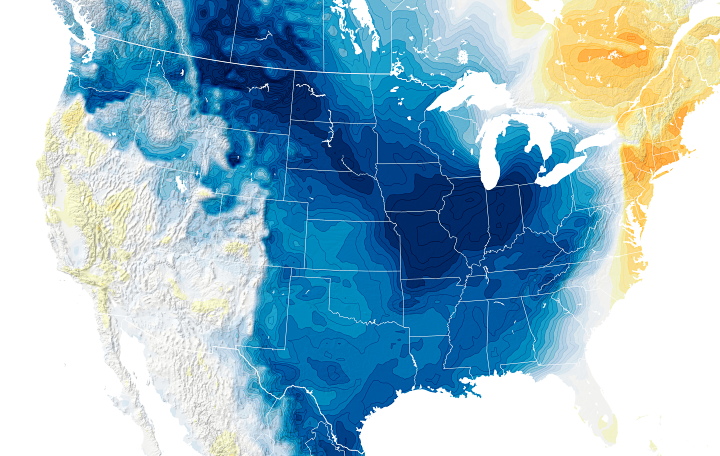
Global Cooling: 2020s, 2030s & 2040s
The Sun’s Grand Minimum
‘Stupid Is As Stupid Does:
Climate Change Pinheads Want To Bury Carbon Dioxide’
By Theodore White, astromet.sci

In all my years as a astrometeorologist who forecasts climate and weather here in the real world, I continue to be amazed at how IQ levels have plummeted – especially among those serving in government.

I also continue to state that there is no such thing as ‘man-made global warming,’ and that CO2 has never has been a threat to the Earth, its atmosphere, climate, weather, nor to humanity.

Carbon good for the Earth. We are made of carbon.

We humans exhale it, the plants and trees inhale carbon and release the oxygen we human beings inhale to exist, right?

When we were kids, we all knew this scientific fact of our climate; our environment; our world.

It was like, 'duh,' no shit Sherlock.

So anyone who does not get that fact (taught in all schools as an unbroken scientific principle during our childhoods) certainly does not have all 52 cards in their deck. That's for sure.

It is the Sun that governs the Earth’s climate.
That is a fact.
Anyone who says otherwise does not have all 52 cards in their deck and has no business whatsoever commenting on the Earth’s climate, much less its weather.

Those who claim that there is ‘man-made climate change’ are living in a total fantasy world where the law of physics and thermodynamics do not exist according to their pea-brained ideas and ridiculous comments on CO2 and the Earth’s climate.

Recently, writer Nicholas Kusnetz reported that:
“A rush is on across the Midwest and Gulf Coast to build thousands of miles of new pipelines that would carry carbon dioxide, the main driver of global warming.
The pipes would become a critical piece of a burgeoning industry that aims to remove the climate pollutant from industrial smokestacks before it reaches the atmosphere, and then store the gas deep underground.

But advocacy groups are warning that energy companies are moving faster than regulators and that some of the proposed pipelines could be up and running before there are any federal safety regulations to cover them.
At least two companies are planning to convert existing natural gas pipelines to carry carbon dioxide instead.
But because of a regulatory loophole, there are currently no federal safety standards for this process.

“This is happening,” said Bill Caram, executive director of the Pipeline Safety Trust, an independent watchdog group.
“These pipelines are getting converted, and in some cases, it’s very clear that they’re not regulated.”

The Pipeline and Hazardous Materials Safety Administration, or PHMSA, is in the process of updating its rules for carbon dioxide pipelines, but the proposed regulations are not expected until next year.

In May 2023, Pipeline Safety Trust and five major environmental groups wrote a letter to Transportation Secretary Pete Buttigieg, who oversees PHMSA, urging him to issue an immediate interim rule stating that all carbon dioxide pipelines are covered under existing regulations until the upcoming rules are in effect.
Caram and other experts say the regulatory gap could pose safety hazards for people living near the pipelines.

Carbon dioxide has different chemical properties than natural gas that could, under certain conditions, corrode or embrittle the pipes that carry it.
In the event of a rupture or leak, CO2 also sinks and can pool in low-lying areas, whereas natural gas rises and tends to disperse more quickly.

Carbon dioxide is an asphyxiant that can cause health problems and even be fatal at high enough concentrations. It can also render vehicle engines inoperable.
Advocates say that without proper regulations, there’s no guarantee that emergency responders would know what to do in the event of an accident.

“This stuff can kill,” said Richard Kuprewicz, an independent consultant and pipeline safety expert.
“I don’t say that to scare anybody. I just say that to say, you have to think this through.”
Across the country, energy companies and other industries are racing to take advantage of a newly-expanded federal tax credit for capturing and storing carbon dioxide and billions of dollars in federal grants and loans for the practice that were approved with the 2021 bipartisan infrastructure bill.

Some projects could reap hundreds of millions of dollars per year for 12 years from the tax credit, which was enhanced as part of the Biden administration’s signature climate legislation enacted last year.

There are currently more than 90 permits to inject CO2 underground awaiting approval from state and federal regulators, and dozens of proposals to build new pipelines and carbon capture operations across the country.

Many environmental advocates have warned that carbon capture and storage could prove to be an enormously expensive and ineffective way to cut the nation’s climate pollution.
They have also raised concerns about new hazards and threats posed by the process, including leaks of carbon dioxide.

Many of the projects would be built in communities that already suffer from the pollution and safety risks posed by industrial operations.
These communities often are home to predominantly Black, Latino and Indigenous people.
But industry groups along with some academics and policy experts have argued that carbon capture could be a key means for reducing pollution from heavy industries like fertilizer production and cement and steel manufacturing.
Ethanol plants across the Midwest and many heavy industries along the Gulf Coast are likely to be some of the first projects to move.

Pipeline proposals have become particularly controversial. PHMSA began updating its rules for carbon dioxide pipelines last year in response to a 2020 rupture of an existing line that sent dozens of people to the hospital.

The existing rules only apply to pipelines that carry CO2 as a “supercritical liquid,” a form it takes under high pressure and temperatures.
Nearly all existing carbon dioxide pipelines, including the one that ruptured, carry the CO2 in a supercritical state because it is far more dense and efficient than piping it in gaseous form.
As a result, that was all federal regulators focused on when they first enacted regulations decades ago.

In 2012, Congress directed the Transportation Department to adopt minimum safety standards for gaseous CO2 pipelines, too, but it has yet to do so.
There are no major pipelines in operation that carry carbon dioxide as a gas, experts say, but there are now at least two conversions in the works.

A company called 'Tallgrass' is planning to convert a pipeline that runs through Nebraska, Colorado and Wyoming, and EnLink Midstream says it plans to convert some of its 4,000 miles of natural gas pipelines in Louisiana.
EnLink has announced deals to carry millions of tons of carbon dioxide annually for ExxonMobil, Occidental Petroleum and others, who plan to capture CO2 from fertilizer plants and other heavy industry.

Last month in June 2023, Louisiana’s Department of Natural Resources updated its safety regulations to extend coverage to all carbon dioxide pipelines, including those carrying it in gaseous form, so the EnLink project would be covered by state regulations.
“CO2 is a whole different critter than it was 10 years ago,” said Patrick Courreges, a department spokesperson, who said the update came in response to plans by EnLink and other companies.

“We need to start looking at what rule changes, what safety standards, what more specificity we’re going to need.”
Caram said the new rules from Louisiana are an improvement but still leave dangerous gaps.
The rules do not set standards for what levels of water or impurities can be mixed into the carbon dioxide as a result of the capturing process, for example.
When water mixes with carbon dioxide, it forms carbonic acid, which is highly corrosive to steel.
There are also no requirements that operators add an odorant, to help residents know a leak has occurred.

Courreges said state regulators would handle those concerns on a case by case basis, and that the regulations set broad guidelines to ensure pipelines are carrying materials consistent with their design.

Megan Wright, an EnLink spokesperson, said that “transporting CO2 as a gas is very similar to transporting natural gas, so we can safely operate our gaseous phase CO2 pipelines at existing pressures where our current natural gas system runs.”
Tallgrass’ Trailblazer project in the Midwest would not currently be covered by any pipeline safety standards.
Rachel Carmichael, a company spokesperson, said that “we expect PHMSA guidance will be in place during the timeframe when Trailblazer is under construction. Currently, we are working with regulators to ensure we comply with their requirements.”
However, the PHMSA rules are still in progress and not yet complete, Caram noted, and will be subject to public review and changes even after the proposed rules are published.
“I have no reason to think Tallgrass is trying to dodge regulatory oversight,” Caram said in response to the company’s statement, “and I believe they would prefer this pipeline to be regulated. But the reality is that it is not.”

In the event that the new federal rules introduce more stringent construction standards, those would not apply to pipelines that have already been completed.
In other words, while existing pipelines might have to change how they operate or are inspected, they likely would not be required to be retrofitted to meet the new construction standards.

In an email, a PHMSA spokesperson said that even though the agency has no regulations to cover gaseous carbon dioxide pipelines, it still has the authority to “investigate and address any safety issues, issue safety orders, and verify compliance with safety orders.”
For some residents and advocates, that is not enough.

Scott Eustis, community science director for Healthy Gulf, a Louisiana-based advocacy group, has been tracking dozens of carbon dioxide pipeline proposals in that state, including many planned to cross fragile and degraded wetlands.
Most of those would carry the gas in supercritical form, and therefore be covered under current federal regulations.
But he said even existing state and federal standards have been inadequate to protect the Louisiana residents from the industries that surround them.
“CO2 is an asphyxiant, so it stops your car motor, it stops your boat motor,” Eustis said.
“We’ve been evacuating thousands of people through oil vapor clouds, but I don’t want to think about what seems to be being contemplated, which is evacuating thousands of people through an asphyxiant cloud.”

Courreges, with the state Department of Natural Resources, said he understands the concerns about safety, but that the projects remain years away from completion.
EnLink would need state approval to convert its natural gas pipelines, he said, but has yet to request it.”

As usual, the Al Gore and John Kerry pinheads continue to push their ‘man-made global warming’ 19th century ideology that originated with the same men who claimed that rocks did not fall from the skies (meteorites) and that the human body could not withstand the speed of 35 miles per hour while sitting on a train.
These were the same men who claimed that the Earth was a closed greenhouse (with glass covering the skies) that trapped heat.
These are the same Goobers and Gilligans pushing the ‘man-made climate change’ propaganda.
Do not believe a word that they say as every single climate prediction they have made has never come true.

Fossil fuels do NOT raise global temperatures and extreme weather is not caused by 'man-made global warming,' or its ideological cover term: 'man-made climate change.'
The Arctic and Antarctic are not melting - but in fact their ice extents have been growing and expanding and this is because for years the Earth has been cooling - not warming - and that is caused by the activity of the Sun.

If you believe in 'man-made global warming' then you have been brainwashed to believe in something that does not exist.
This was confirmed by physicists Gerlich and Tscheuschner, who stated in their 2009 scientific paper published in the International Journal of Modern Physics, titled: 'Falsification Of The Atmospheric CO2 Greenhouse Effects Within The Frame Of Physics,' that:
"The atmospheric greenhouse effect, an idea that many authors trace back to the traditional works of Fourier (1824) Tyndall (1861) and Arrhenius (1896) and which is STILL supported in global climatology essentially describes a fictitious mechanism.
That mechanism is where a planetary atmosphere acts as a heat pump driven by an environment that is radiatively interacting with but radiatively equilibrated to the atmospheric system.

According to the Second Law of Thermodynamics - such a planetary machine can never exist.
That means that man-made global warming is impossible.

Those who want to know the truth about their own planet’s climate and how it functions can go to the link attached.
And remember, the truth will set you free.
See ->>
https://solarcycle25com.proboards.com/.../climate-phases...
 

northern watch

TB Fanatic

Some wildfire evacuations end in British Columbia, but fire threatens community farther north​

The wildfire situation has showed some improvement in British Columbia, with more people being allowed to return to their homes over the weekend, but blazes continue to threaten communities in Canada’s Northwest Territories
By JIM MORRIS Associated Press
August 27, 2023, 6:55 PM

Canada Wildfires

Thick smoke from the Lower East Adams Lake wildfire fills the air around a Canadian flag fluttering in the wind as Royal Canadian Mounted Police officers on a boat patrol Shuswap Lake, in Scotch Creek, British Columbia, on Sunday, Aug. 20, 2023. (Darryl Dyck/The Canadian Press via AP)

VANCOUVER, British Columbia -- The wildfire situation showed some improvement in British Columbia on Sunday, with more people being allowed to return home, but blazes continued to threaten communities farther north in Canada's Northwest Territories.

Hot temperatures and winds expected to gust to up to 40 kph (25 mph) were fanning flames around the Northwest Territories town of Hay River, on the south shore of Great Slave Lake
.

The blaze, which has burned across 4,000 square kilometers (1,544 square miles), was about a kilometer (one-half mile) west of the town's airport and 1.5 kilometer (one mile) from the town center.

“These conditions are supportive of the potential for severe fire activity,” Mike Westwick, a fire information officer for the Northwest Territories government, said in a telephone interview. “We’ve got a big team of firefighters on the ground who are doing everything they can to prevent that eventuality."

On Saturday, the fire destroyed two cabins and a travel trailer near the shore of Great Slave Lake.

Over 200 people were battling the fire along with 10 helicopters, 21 pieces of heavy equipment and airtankers.

About 240 wildfires were burning in Canada’s northern territory. So far, 296,678 hectares (733,107 acres) had been affected.

Canada has seen a record number of wildfires this year, and their choking smoke has sometimes reached into the United States.

Fire crews also continued to battle a blaze near the Northwest Territories capital of Yellowknife. That fire has burned over 1,670 square kilometers (645 square miles), but firefighters have kept it to 15 kilometers (nine miles) northwest of the city’s boundaries for at least a week and a half. The fire forced the evacuation of nearly all of the city’s 20,000 residents.

“The team is doing some really good work on the ground there to reduce those risks and to support a safe return as soon as possible,” Westwick said.

To the south, British Columbia reported 370 active blazes, including 12 designated as ``wildfires of note,″ meaning they are highly visible or pose a threat to public safety.

Donna MacPherson, a fire information officer with the BC Wildfire Coordination Centre, said the province was still feeling the effects of above normal temperatures and the chance of lightning.

“It’s not over yet for us by a longshot,” she said. “It’s been a really long fire season and we’ve still got some to go before it’s over.”

The BC Wildfire Service said the West Kelowna fire department was returning to ``normal day-to-day operations″ 10 days after a fast-moving wildfire forced thousands to flee that town and went on to destroy more than 170 homes in the area.

An additional 1,800 people were allowed to return their homes in that area this weekend as evacuation orders in communities on both sides of Okanagan Lake were lifted. The Central Okanagan Emergency Operations Centre said evacuation orders were still in effect for 1,588 properties in West Kelowna and 1,114 in rural areas of the regional district as well as on Westbank First Nation lands.

The McDougall Creek wildfire, responsible for much of the destruction in the West Kelowna area, still burned out of control over 123 square kilometers (47 square miles).

A 430-square-kilometer (166-square-mile) fire in the Shuswap region has destroyed more than 130 structures and damaged about 40 others.

MacPherson said the shortening days with the approach of fall usually mean cooler weather, but temperatures remained high across the province.

“Everywhere is warmer than it normally is at this time of year,” she said.

The provincial seven-day forecast calls for rain beginning Tuesday and lasting until the weekend.

But MacPherson said, “From our standpoint, we’re still looking for fire to be in B.C. for some time to come.”


northern watch

TB Fanatic
HEAVY SNOW REVIVES NEW ZEALAND’S RUAPEHU RESORT; BANFF, ALBERTA REPORTS FIRST SNOWFALL OF THE SEASON; + LOW SUNSPOT COUNT
AUGUST 28, 2023 CAP ALLON
Electroverse.

HEAVY SNOW REVIVES NEW ZEALAND’S RUAPEHU RESORT

New Zealand’s Ruapehu ski field has been blasted with healthy dumpings of snow. Record snow, in fact, has crowned the North Island mountain, according to 1news.co.nz: Ruapehu is boasting the world’s deepest snow base, at 2.55cm (8.4ft).


This is a stark turnaround from events last year when the resort was closed due to a severe bout of ‘global boiling’ — a closure which was effectively on course to liquidate the business until the NZ government stepped in with a $5 million “lifeline”.

Looking forward, Ruapehu Chief Operating Officer Travis Donaghue said the best days of the season are yet to come.
“We’ll keep rolling that title out [World’s Deepest Snow Base] for a while yet, we have a long season to come. It runs right through to Labour weekend so we’re not yet halfway,” said Donaghue.

“We tend to have great conditions later in the year when we don’t see as many frosts so this base will set us up perfectly.”

Skiers are also returning to the slopes.

Hotel owner Ben Tuck said he was booked up for the season: “Compared to last year, we were only a quarter full, and to now have every weekend full is just outstanding, very grateful,” he said of the swing between extremes.

TCB ski-shop owner Ben Wiggins said this past month has been a huge relief for Ohakune businesses: After four years of doing it tough with tourist numbers and weather, this was special,” said Wiggins. “Not only do we have the business relief, but we also have the relief of coming up and shredding on all this snow. We’re all up here enjoying it and the town is enjoying it as well.”

After the recent wobbles of Covid and the liquidation process, all mountain lovers are stoked to have things back in balance, concludes the reports1news.co.nz article.

BANFF, ALBERTA REPORTS FIRST SNOWFALL OF THE SEASON

The memory of North America’s truly historic winter of 2022/23 is still fresh, yet already a myriad of mountains have received their first snows of the new season; the most recent addition being Sunshine Village Ski Area, in Banff, Alberta.

The Village uploaded the season’s first flakes to Instagram:

Banff is home to three world-class resorts: Sunshine Village, Lake Louise, and Mount Norquay, which together are known as the “Big Three.” The former, Sunshine Village, is known for attracting snowboarders from around the world due to the plentiful volumes of natural snow that the area receives which typically builds from early-November to late-May.

Does this early snow mean a cold and snowy winter is on the cards?

The Farmer’s Almanac seems to think so, with its calls of well-below average temperatures and significant snowfalls:


Canada’s 2023/24 Winter Outlook is a cold one [Farmers’ Almanac].

The Almanac predicts a story for south of the border, too, for the United States:


An unseasonably cold/wet forecast suggests an ‘active’ winter for many Americans.


LOW SUNSPOT COUNT

Over the weekend, an M1-class solar flare near the Sun’s eastern limb hurled a coronal mass ejection (CME) toward Mars.
NASA modeling suggests the Red Planet will be hit on Friday, September 1:


The impact could spark ultraviolet auroras and erode a small amount of the Martian atmosphere, writes Dr Tony Phillips of spaceweather.com.

Looking elsewhere over the Earth-facing solar disk, other than sunspot AR3415, which posses a ‘beta-delta’ magnetic field that harbors energy for additional M-class solar flares, there really isn’t much to speak of.

Solar Cycle 25 has, at times, impressed when compared to its predecessor, the historically weak SC24. But for an approaching solar maximum, which most solar physicists have determined will arrive early, in 2024, this isn’t exactly ‘all cylinders firing’:


[SDO/HMI]

Solar Cycle 26 is where I’ve long contended the ‘chill of solar minimum’ will begin. An uneventful fizzling out of SC25 will only add support to this.

 
Last edited:

TheSearcher

Are you sure about that?
HEAVY SNOW REVIVES NEW ZEALAND’S RUAPEHU RESORT; BANFF, ALBERTA REPORTS FIRST SNOWFALL OF THE SEASON; + LOW SUNSPOT COUNT
AUGUST 28, 2023 CAP ALLON
Electroverse.

HEAVY SNOW REVIVES NEW ZEALAND’S RUAPEHU RESORT

New Zealand’s Ruapehu ski field has been blasted with healthy dumpings of snow. Record snow, in fact, has crowned the North Island mountain, according to 1news.co.nz: Ruapehu is boasting the world’s deepest snow base, at 2.55cm (8.4ft).


This is a stark turnaround from events last year when the resort was closed due to a severe bout of ‘global boiling’ — a closure which was effectively on course to liquidate the business until the NZ government stepped in with a $5 million “lifeline”.

Looking forward, Ruapehu Chief Operating Officer Travis Donaghue said the best days of the season are yet to come.
“We’ll keep rolling that title out [World’s Deepest Snow Base] for a while yet, we have a long season to come. It runs right through to Labour weekend so we’re not yet halfway,” said Donaghue.

“We tend to have great conditions later in the year when we don’t see as many frosts so this base will set us up perfectly.”

Skiers are also returning to the slopes.

Hotel owner Ben Tuck said he was booked up for the season: “Compared to last year, we were only a quarter full, and to now have every weekend full is just outstanding, very grateful,” he said of the swing between extremes.

TCB ski-shop owner Ben Wiggins said this past month has been a huge relief for Ohakune businesses: After four years of doing it tough with tourist numbers and weather, this was special,” said Wiggins. “Not only do we have the business relief, but we also have the relief of coming up and shredding on all this snow. We’re all up here enjoying it and the town is enjoying it as well.”

After the recent wobbles of Covid and the liquidation process, all mountain lovers are stoked to have things back in balance, concludes the reports1news.co.nz article.

BANFF, ALBERTA REPORTS FIRST SNOWFALL OF THE SEASON

The memory of North America’s truly historic winter of 2022/23 is still fresh, yet already a myriad of mountains have received their first snows of the new season; the most recent addition being Sunshine Village Ski Area, in Banff, Alberta.

The Village uploaded the season’s first flakes to Instagram:

Banff is home to three world-class resorts: Sunshine Village, Lake Louise, and Mount Norquay, which together are known as the “Big Three.” The former, Sunshine Village, is known for attracting snowboarders from around the world due to the plentiful volumes of natural snow that the area receives which typically builds from early-November to late-May.

Does this early snow mean a cold and snowy winter is on the cards?

The Farmer’s Almanac seems to think so, with its calls of well-below average temperatures and significant snowfalls:


Canada’s 2023/24 Winter Outlook is a cold one [Farmers’ Almanac].

The Almanac predicts a story for south of the border, too, for the United States:


An unseasonably cold/wet forecast suggests an ‘active’ winter for many Americans.


LOW SUNSPOT COUNT

Over the weekend, an M1-class solar flare near the Sun’s eastern limb hurled a coronal mass ejection (CME) toward Mars.
NASA modeling suggests the Red Planet will be hit on Friday, September 1:


The impact could spark ultraviolet auroras and erode a small amount of the Martian atmosphere, writes Dr Tony Phillips of spaceweather.com.

Looking elsewhere over the Earth-facing solar disk, other than sunspot AR3415, which posses a ‘beta-delta’ magnetic field that harbors energy for additional M-class solar flares, there really isn’t much to speak of.

Solar Cycle 25 has, at times, impressed when compared to its predecessor, the historically weak SC24. But for an approaching solar maximum, which most solar physicists have determined will arrive early, in 2024, this isn’t exactly ‘all cylinders firing’:


[SDO/HMI]

Solar Cycle 26 is where I’ve long contended the ‘chill of solar minimum’ will begin. An uneventful fizzling out of SC25 will only add support to this.

Here it comes...
 

dawgofwar10

Veteran Member
I am an old Tard, I don’t know how make a new post. But damnit stay with me Dennis, pull up those Boot Straps and Don’t quit on me, life sucks and it will eventually envelope you. But fight and fight some more, do not give up, you have a lot pups depending on you, and all of us praying for You.
 

northern watch

TB Fanatic

12 Signs of a Bad Winter: Acorns, Onion Skins, and Weather Folklore​

onion-1627132_1920.jpg


Will this winter be warm and mild or snowy and cold?​

James J. Garriss
September 11, 2023
The Old Farmer's Almanac

The weather-predicting business is a tough one. How do you know if the winter will be exceptionally snowy? Is it going to be a cold, long winter? According to folklore, all you need to do is look at the squirrels! Or measure the thickness of onion skins! Let’s look at signs of a bad winter according to weather lore passed down through the ages.

What do the Squirrels Know?​

The squirrels offer up some impressive rodent wisdom as well.

Squirrels gathering nuts in a flurry,

Will cause snow to gather in a hurry.

That makes sense. If winter is going to be cold, better store up more food! In addition, a tough winter is ahead if squirrels’ tails are very bushy. Even squirrel nesting patterns tell us how cold a winter will be. Nests higher in trees suggest a colder, snowier winter; nests located lower in trees suggest a milder winter.

Squirrels gathering nuts in a flurry,  Will cause snow to gather in a hurry. weather folkore graphic with house in snow with snowy trees

The Birds and the Bees​

In this case, knowing the “birds and the bees” is about closer observation of nature. As with squirrels, when birds migrate early, or bees build their nests high in the trees, the winter is going to be awful. The old saying goes:
See how high the hornets nest,
‘twill tell how high the snow will rest.

Larger spider webs are also signs of a bad winter.

The Famous Woolly Worm​

How about the woolly worms? Ever seen those fuzzy-wuzzy worms cross the road in autumn? The furry bands of brown and rust on a woolly caterpillar will tell you if the upcoming winter will be cold.

1024px-chrysanthemum.show__full_width.jpg

Are your chrysanthemums really pretty? Get out the mittens.” Even the flowers know!
Source: Wikimedia

Onion, Apple, and Corn​

Then there are the onion skins! Folklore claims that thicker onion skins can signal a cold and snowy winter.

Onion’s skin very thin,
Mild winter coming in;
Onion’s skin thick and tough,
Coming winter cold and rough.

–Gardener’s Rhyme Same with tough apple skins!
Other plants and trees also give cues about rain and cold weather if you observe closely.
  • Like onions, thick skins on apples signal a bad winter.
  • And thicker than normal corn husks indicate a harsh winter, too.
  • Flowers in bloom late in autumn indicate a lousy winter.
  • When leaves drop early, autumn and winter will be mild; but if they fall late, winter will be severe.

Weather Lore and Science Go Together​

Some of these are based on old-fashioned observation. But some goes back to science.

Interestingly, weather folklore warning of a harsh winter is based on La Niña and El Nino which are natural climate phenomenon related to the temperatures of the oceans. So, it’s a little bit of art and science!
  • La Niña conditions tends to be dry in summer and cold in winter, so if birds leave early, the leaves fall quickly, onions and apples are tough, and caterpillars are short, it may be due to the La Niña drought. A miserable La Niña winter will follow.
  • El Niño conditions (which are expected for winter 2023) typically result in wetter-than-average conditions from southern California to along the Gulf Coast and drier-than-average conditions in the Pacific Northwest.
Other folklore is just based on the idea that you shouldn’t let your guard down. Lots of berries, nuts, and flowers may be the sign of a lovely warm November. However, weather wise, winter will probably be awful.


northern watch

TB Fanatic

FACTORS COMBINE TO SUGGEST A POWERFUL ARCTIC OUTBREAK (POLAR VORTEX) COULD STRIKE THIS WINTER​

SEPTEMBER 14, 2023 CAP ALLON
Electroverse

Winter 2023-24 is approaching, and a new Polar Vortex is strengthening in the Stratosphere over the North Pole.
In recent years, the phrase ‘Polar Vortex’ has been adopted by the climate cabal to mean descending Arctic air masses. In this article it will reflect the strength of the stratospheric polar circulation which, whether it be weak or strong, plays a crucial part in our Winter weather.

As we head into autumn, the Sun gets lower and the polar regions begin to cool as there is less energy to fuel them.
However, as polar temperatures drop, the atmosphere further south remains relatively warm. This causes a strong temperature difference between the polar and sub-tropical regions, and a large low-pressure (cyclonic) circulation starts to develop across the Northern Hemisphere, extending from the surface layers to high up into the atmosphere — the ‘Polar Vortex’.

Climate alarmists claim that a warming Arctic is leading to an increase in violent storms. However, if the Arctic is indeed warming “twice as fast as the rest of the planet”, as is also claimed, then the temperature difference between it and the lower latitudes will actually decrease which, The Science informs, will lead to less favorable conditions for low pressure systems to develop.

Key to note, the Polar Vortex is not just one winter storm or a single cold outbreak. Rather, it is a large cyclonic area spinning above the entire Northern Hemisphere, from the ground to the top of the Stratosphere–and beyond to over 50 km (31 miles).


https://i0.wp.com/electroverse.info/wp-content/uploads/2023/09/image-46.png?ssl=1
Polar Vortex at around 30 km (18.5 miles) during Winter. Temperatures drop quickly as you approach its cold inner core.

The strength of this stratospheric polar circulation (Polar Vortex) can mean the difference between a very cold and snowy winter and a warm and dry winter.

Though not an exact science, a strong Polar Vortex will see cold air locked in the Polar regions, meaning milder conditions for the mid-latitudes. Conversely, weak Polar Vortex will lead to a looser polar jet stream flow, and the Arctic will have a harder time containing its cold air which is now free to escape south and crash into the likes of North America and/or Europe:

polar-vortex-weather-forecast-north-hemisphere-what-is-strong-weak-polar-vortex-winter-pattern-ssw

By a logical extension, solar activity can also contribute to the stability of the jet streams.

Since around 2008, solar output has been holding at historically low levels. Combined, the past two solar cycles (24 and the ongoing 25) are on course to be the weakest pair of cycles since those of the Dalton Minimum (1795 – 1815).

This low output is appears to be changing our weather by weakening the jet streams, which has the effect (in the NH) of either pulling up Tropical warmth to unusually-high latitudes, or dragging down Polar cold unusually-far south.


A 2022 study in Nature attributed the increasing number European heatwaves (ignoring the lower qualifying criteria) to a ‘wavy jet stream’. Of course, the opposite –i.e. cold outbreaks– are also on the increase, but the Scientific community isn’t set up to reward such an exploration.

We saw this–a weakening/wavy jet stream flow–in Europe just last week:

COOLING OVER THE NORTH POLE HAS ALREADY BEGUN

This Stratospheric cooldown will intensify through the remainder of September and October, reaching its lowest temperatures in December–when the Polar Vortex is usually at its strongest.

Below is NASA‘s mid-stratosphere temperature chart over the north pole.

The pink line (within the red box, a little hard to distinguish) is the latest analysis.
It shows that the Polar Vortex is currently running colder than normal.

polar-vortex-weather-winter-middle-stratosphere-temperature-graph-2023-2024-nasa-data-analysis

The temperature is dropping hard in the Stratosphere at around the 30 km (18.5 miles) altitude mark.

The next image, courtesy of severe-weather.eu, shows the temperature change forecast for late September.

Clear to see, the mercury over and around the North Pole will take a sharp plunge over the next 10-or-so days:

polar-vortex-16-day-stratosphere-temperature-change-cooling-cold-weather-season-latest-data

And looking at the actual temperature forecast, we can see a cold core developing over the polar circle — the colder this core gets, the stronger the Polar Vortex can become (as it feeds off the temperature/pressure difference between the polar and southern regions).

polar-vortex-winter-2023-2024-mid-stratosphere-temperature-september-16-day-forecast

THE QUASI-BIENNIAL OSCILLATION (QBO)

There are many other forcings at play determining the activity of the polar vortex–many we don’t understand or have likely even noticed.

The Quasi-Biennial Oscillation (QBO) is one such key aspect of weather development in Winter that can affect the Polar Vortex and the jet stream. The power and direction of the winds in the polar jet stream can change with the QBO.

Long story short, the QBO is a regular variation of the winds high above the Equator. These winds change from west to east every 14-or-so months. A wind analysis for the 10mb level (see below) shows a negative wind stream above the tropical regions. The negative values mean that easterly winds are prevalent. This means that the QBO is in the east (negative) mode.


The QBO is worth paying attention to because its easterly (negative) phase gives an increased chance of a weaker jet stream, sudden stratospheric warming (SSW) events, and so harsher winters for the likes of North America and Europe.

Conversely, a strong polar vortex usually arises when the QBO is in its westerly (positive) phase which increases the chances of those cold polar air masses remaining locked in the Arctic–they have a harder time punching out of the strong circulation–which makes for a milder winter across the mid-latitudes.

SUDDEN STRATOSPHERIC WARMING EVENT

Typically, a Polar Vortex weakens due to a rise in temperature and pressure in the Stratosphere — a Sudden Stratospheric Warming (SSW) event. Such a setup will often collapse the Polar Vortex which then beings a chain reaction, disrupting the jet stream, creating high pressure over the Arctic Circle, and releasing the cold Arctic air into the U.S. and Europe.

An SSW event is usually triggered by specific pressure patterns in the lower levels that can send a lot of energy upwards vertically into the Stratosphere. The image below shows an example of a typical SSW event and how it progresses over a 30-day period:

winter-2023-2024-sudden-stratospheric-warming-evolution-schematic

Such an event played out in February this year (2023).

Warming gripped the Polar Vortex, and with the pressure rising in the Stratosphere and the winds reversing, a full-blown SSW event was soon marked. The disruption occurred on a large scale and extended over much of the Stratosphere.

However, though strong, it still takes time for weather effects to filter down to the lower layers. It wasn’t until two weeks after the initial SSW event that the resulting pressure pattern was fully established. The main result back in Feb was a strong blocking high over Greenland, with displaced low-pressure systems from the United States over the North Atlantic into Northern Europe.

winter-polar-vortex-north-hemisphere-forecast-pressure-gefs-ensemble-united-states-snowfall

This pressure pattern is a textbook ‘weak vortex event’ — the cold polar air easily escape the Arctic and crashed into the lower latitudes.

This event mercifully spared the majority Europe (given the energy woes there). Looking at the temperature anomalies for that time, we see a strong cold outbreak that was confined to the United States, particularly the West — a setup which no doubt contributed to those 19+ Western ski resorts posting their highest winter snowfall totals of all-time.

winter-polar-vortex-north-hemisphere-forecast-surface-temperature-ecmwf-ensemble-united-states-canada-cold

ENSO PHASE (EL NIÑO)

The ENSO phase can also increase the chances of a Polar Vortex disruption event occurring.

The graph below depicts the typical SSW event frequency by month and by the ENSO phase.

An El Niño setup, which we’re in now, has a higher chance of producing a Polar Vortex collapse event in the early parts of winter. Typically, major SSW events do occur during this period (Dec/early-Jan) — so that’s another box ticked.

polar-vortex-collapse-weather-forecast-winter-2023-2024-el-nino-el-nino-data-update

FORECAST

Looking ahead, the EMCWF stratospheric temperature anomaly forecast for 30 km (18.5 miles) suggests that we’re set for a warmer polar region, which hints at a potentially weaker Polar Vortex:

polar-vortex-winter-2023-2024-mid-stratosphere-temperature-anomaly-forecast-january-ssw-ecmwf-latest

While impossible to forecast a SSW this far out, historical patterns, trends, emerging signals, and an overall global configuration point to a high probability that a collapsing stratospheric circulation and subsequent ‘Arctic Outbreak’ will hit this winter, spelling hardships and misery for mid-latitudes residents–particularly Europeans given the suicidal energy policies there.

We certainly have signals to keep an eye on, is all I’m saying.

More than that though–and for whatever it’s worth–this winter feels to me like it’s going be a cold, snowy and all-round testing one.

Bring it on.

 
Last edited:
Top