
You are using an out of date browser. It may not display this or other websites correctly.
You should upgrade or use an alternative browser.
You should upgrade or use an alternative browser.
Solar Grand Solar Minimum part deux
- Thread starter Dennis Olson
- Start date
-
- Tags
- grand solar minimum
alpha
Veteran Member
Electroverse
 Articles Extreme Weather GSM
Century-Old Lows Fall Across Iowa; Toronto’s Delayed Spring; + La Niña “Struggling To Break”, Expected To Linger Into Winter
April 27, 2022 Cap Allon
Century-Old Lows Fall Across Iowa
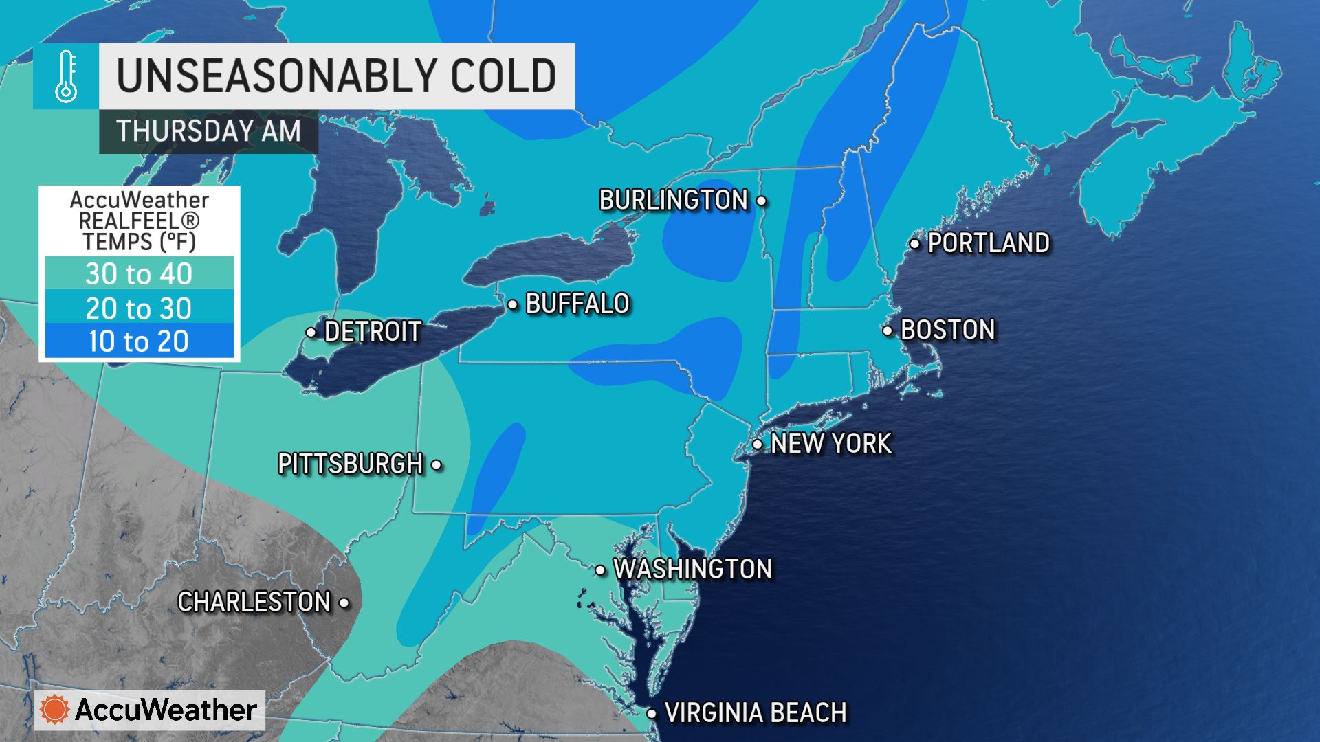
Vast, record-breaking pockets of Arctic air are continuing to invade North America this week, even as the calendar nears May.
On Tuesday morning, at least five Iowa cities set record low temperatures for the date: Ottumwa, Cedar Rapids, Huron, and Burlington all busted benchmarks, with Sioux City tying the other.
Ottumwa saw a temperature of 26F at 6 a.m. Tuesday, breaking the previous record of 29F set in 1926; Cedar Rapids dipped to 22F, busting its old low of 24 set way back in 1907; Huron dropped to 21F, usurping the old record of 22F from 1931; Burlington suffered 30F and in the process pipped its previous low of 31F, which was set in 1976; and finally, Sioux City’s 25F tied the low from 1950.
 GFS 2m Temperature Anomalies (C) April 26 – May 5 [tropicaltidbits.com].
This rare late-April chill is being felt across a large swathe of North America, not just Iowa:

And the anomalous freeze is negatively impacting crop planting, compounding the misery caused by the ‘controlled demolition’ of our food supply–such as the massively-reduced planting in the Ukraine and Russia (who supply 30% of the world’s grain), and the refusal of the Russian Federation to supply fertilizers (and grain itself) to ‘unfriendly’ nations: no fertilizers (or herbicides/pesticides–also reduced) = drastically lower crop yields.
This crisis will be coming to a head soon, perhaps even by harvest time 2022 (Sept/Oct).
Prepare for the ‘penny to drop’ among the masses — expect a price shock, perhaps shortages and even rationing.
I know this message is on the extreme side, conspiratorial even, but the historical literature is littered with such collapses, shortages, suffering, and famines–and back during periods of history when a majority of the people grew their own food, too.
There is a collapse inbound.
It’s baked in, all-but guaranteed — and it’s one fully orchestrated by the elites.
How will the masses handle the silos running dry, or all the poultry being culled (in the name of “bird flu”)? Picture the sheer panic at the sight of empty grocery store shelves, and that sinking realization of “what now?”.
How do you think our modern fragile society will fare when the state’s sustaining teat is removed? It will be chaos. Truly. Looting, fire and death. But it’s from these ashes that TPTB will rise, and with no meaningful resistance they will be free ‘build back better’ in whatever totalitarian order they see fit. The ‘lucky’ surviving 20-30%, now beaten down and hungry after months/years of struggle, strife and the omnipresent threat of starvation will mercifully accept any proposed regime, no matter how draconian, authoritarian or backwards, because it will surely beat seeing your children go hungry.
This, at least to me, appears to be their plan. I can find no other reasoning. They kindly set-up the sections of society for us, and got us utterly dependent on them, but like a domino run they’ve now triggered the first one and have created a chain reaction of disruption–a collapse that their now idly standing by and watching without a thought of intervention even as mass starvation looms.
The Rockefellers, World Bank, IMF And WEF All Warn Of A “Massive Global Food Crisis”

The world faces a “human catastrophe” from a food crisis. The elites are broadcasting warnings. Heed them.
 Electroverse
Toronto’s Delayed Spring
As in the U.S., spring is proving something of a ‘no show’ north of the border, too.
Taking Toronto as our example, the Ontario capital is on the cusp of busting a historical record.
According to The Weather Network meteorologist Rachel Modestino, if the city doesn’t hit 20F by May 3 then this year will have seen the latest 20C (68F) since 1993 — and looking at the forecast, this seems highly likely.
Also entirely possible, again according to Modestino, is Toronto not seeing its first 20F much further into May, which would threaten the city’s all-time latest 20C (68F)-day, currently held by May 19, 1978.
“Next week will be a roll of the dice when it comes to 20C weather, as we will need a well-timed sunny break with a southerly breeze to get it, but the odds are beginning to stack up against us,” said Modestino.
La Niña “Struggling To Break”, Expected To Linger Into Winter 2022-23
La Niña is an oceanic and atmospheric phenomenon that is the colder counterpart of El Niño, as part of the broader El Niño–Southern Oscillation climate pattern — the latest forecast for a prolonged or ‘double-dip’ La Niña is noteworthy.
Very briefly, La Niña is characterized by unusually cold ocean temperatures in the Equatorial Pacific (region 3.4). The climate pattern tends to generate colder, snowier conditions across much of North America, Europe and Asia, and a wetter, stormier weather in Australia.

Meteorologist Dennis Todey, director of the USDA’s Midwest Climate Hub in Ames, says the experts had expected La Niña to fade this spring. Moreover, La Niña conditions commenced in mid-2020 and then made a surprise return in late-2021 –with NOAA infamously tweeting “she’s baaaaaaaaack!“– but for La Niña to persist through 2022 would be something really quite unusual.
Shown below is the monthly sea surface temperatures of region 3.4.
Revealed is 1) the first La Niña ‘dip’, 2) the return in late-2021, and 3) the new down turn as of March 2022–when experts saw us climbing above the ‘La Niña threshold’:

The below ‘upper-ocean’ temperature anomaly chart also clearly shows the prevailing cold, through early-April:

While the latest high-resolution depth analysis ‘under’ the ENSO regions also confirms the return of colder-than-normal temperatures:

Looking ahead, the ENSO forecast from the CFSv2 (shown below) has the current cooling extending deep into 2022, perhaps even well into the winter of 2022/2023 — a rare 3-year cold event.

In North America, the main feature of a La Niña winter is a persistent high-pressure system in the North Pacific. This usually sees the jet stream descend from the NW down into the SE, bringing colder weather conditions with it:

While a La Niña summer tends to see blocking high-pressure system in the North Pacific:

However, I contend that these are unprecedented climatic times that we’re entering into, driven by historical low solar activity, electrical changes, and increased cosmological forcings (such as an influx of cosmic rays) — in other words, it’s a wait and see…
The COLD TIMES are returning, the mid-latitudes are REFREEZING in line with historically low solar activity, cloud-nucleating Cosmic Rays, and a meridional jet stream flow (among many other forcings, including the impending release of the Beaufort Gyre). Prepare accordingly — learn the facts, relocate if need be, and grow your own.
Century-Old Lows Fall Across Iowa; Toronto’s Delayed Spring; + La Niña “Struggling To Break”, Expected To Linger Into Winter
April 27, 2022 Cap Allon
Century-Old Lows Fall Across Iowa
Vast, record-breaking pockets of Arctic air are continuing to invade North America this week, even as the calendar nears May.
On Tuesday morning, at least five Iowa cities set record low temperatures for the date: Ottumwa, Cedar Rapids, Huron, and Burlington all busted benchmarks, with Sioux City tying the other.
Ottumwa saw a temperature of 26F at 6 a.m. Tuesday, breaking the previous record of 29F set in 1926; Cedar Rapids dipped to 22F, busting its old low of 24 set way back in 1907; Huron dropped to 21F, usurping the old record of 22F from 1931; Burlington suffered 30F and in the process pipped its previous low of 31F, which was set in 1976; and finally, Sioux City’s 25F tied the low from 1950.
 GFS 2m Temperature Anomalies (C) April 26 – May 5 [tropicaltidbits.com].
This rare late-April chill is being felt across a large swathe of North America, not just Iowa:

And the anomalous freeze is negatively impacting crop planting, compounding the misery caused by the ‘controlled demolition’ of our food supply–such as the massively-reduced planting in the Ukraine and Russia (who supply 30% of the world’s grain), and the refusal of the Russian Federation to supply fertilizers (and grain itself) to ‘unfriendly’ nations: no fertilizers (or herbicides/pesticides–also reduced) = drastically lower crop yields.
This crisis will be coming to a head soon, perhaps even by harvest time 2022 (Sept/Oct).
Prepare for the ‘penny to drop’ among the masses — expect a price shock, perhaps shortages and even rationing.
I know this message is on the extreme side, conspiratorial even, but the historical literature is littered with such collapses, shortages, suffering, and famines–and back during periods of history when a majority of the people grew their own food, too.
There is a collapse inbound.
It’s baked in, all-but guaranteed — and it’s one fully orchestrated by the elites.
How will the masses handle the silos running dry, or all the poultry being culled (in the name of “bird flu”)? Picture the sheer panic at the sight of empty grocery store shelves, and that sinking realization of “what now?”.
How do you think our modern fragile society will fare when the state’s sustaining teat is removed? It will be chaos. Truly. Looting, fire and death. But it’s from these ashes that TPTB will rise, and with no meaningful resistance they will be free ‘build back better’ in whatever totalitarian order they see fit. The ‘lucky’ surviving 20-30%, now beaten down and hungry after months/years of struggle, strife and the omnipresent threat of starvation will mercifully accept any proposed regime, no matter how draconian, authoritarian or backwards, because it will surely beat seeing your children go hungry.
This, at least to me, appears to be their plan. I can find no other reasoning. They kindly set-up the sections of society for us, and got us utterly dependent on them, but like a domino run they’ve now triggered the first one and have created a chain reaction of disruption–a collapse that their now idly standing by and watching without a thought of intervention even as mass starvation looms.
The Rockefellers, World Bank, IMF And WEF All Warn Of A “Massive Global Food Crisis”
The world faces a “human catastrophe” from a food crisis. The elites are broadcasting warnings. Heed them.
Toronto’s Delayed Spring
As in the U.S., spring is proving something of a ‘no show’ north of the border, too.
Taking Toronto as our example, the Ontario capital is on the cusp of busting a historical record.
According to The Weather Network meteorologist Rachel Modestino, if the city doesn’t hit 20F by May 3 then this year will have seen the latest 20C (68F) since 1993 — and looking at the forecast, this seems highly likely.
Also entirely possible, again according to Modestino, is Toronto not seeing its first 20F much further into May, which would threaten the city’s all-time latest 20C (68F)-day, currently held by May 19, 1978.
“Next week will be a roll of the dice when it comes to 20C weather, as we will need a well-timed sunny break with a southerly breeze to get it, but the odds are beginning to stack up against us,” said Modestino.
La Niña “Struggling To Break”, Expected To Linger Into Winter 2022-23
La Niña is an oceanic and atmospheric phenomenon that is the colder counterpart of El Niño, as part of the broader El Niño–Southern Oscillation climate pattern — the latest forecast for a prolonged or ‘double-dip’ La Niña is noteworthy.
Very briefly, La Niña is characterized by unusually cold ocean temperatures in the Equatorial Pacific (region 3.4). The climate pattern tends to generate colder, snowier conditions across much of North America, Europe and Asia, and a wetter, stormier weather in Australia.

Meteorologist Dennis Todey, director of the USDA’s Midwest Climate Hub in Ames, says the experts had expected La Niña to fade this spring. Moreover, La Niña conditions commenced in mid-2020 and then made a surprise return in late-2021 –with NOAA infamously tweeting “she’s baaaaaaaaack!“– but for La Niña to persist through 2022 would be something really quite unusual.
Shown below is the monthly sea surface temperatures of region 3.4.
Revealed is 1) the first La Niña ‘dip’, 2) the return in late-2021, and 3) the new down turn as of March 2022–when experts saw us climbing above the ‘La Niña threshold’:

The below ‘upper-ocean’ temperature anomaly chart also clearly shows the prevailing cold, through early-April:

While the latest high-resolution depth analysis ‘under’ the ENSO regions also confirms the return of colder-than-normal temperatures:

Looking ahead, the ENSO forecast from the CFSv2 (shown below) has the current cooling extending deep into 2022, perhaps even well into the winter of 2022/2023 — a rare 3-year cold event.

In North America, the main feature of a La Niña winter is a persistent high-pressure system in the North Pacific. This usually sees the jet stream descend from the NW down into the SE, bringing colder weather conditions with it:

While a La Niña summer tends to see blocking high-pressure system in the North Pacific:

However, I contend that these are unprecedented climatic times that we’re entering into, driven by historical low solar activity, electrical changes, and increased cosmological forcings (such as an influx of cosmic rays) — in other words, it’s a wait and see…
The COLD TIMES are returning, the mid-latitudes are REFREEZING in line with historically low solar activity, cloud-nucleating Cosmic Rays, and a meridional jet stream flow (among many other forcings, including the impending release of the Beaufort Gyre). Prepare accordingly — learn the facts, relocate if need be, and grow your own.
northern watch
TB Fanatic
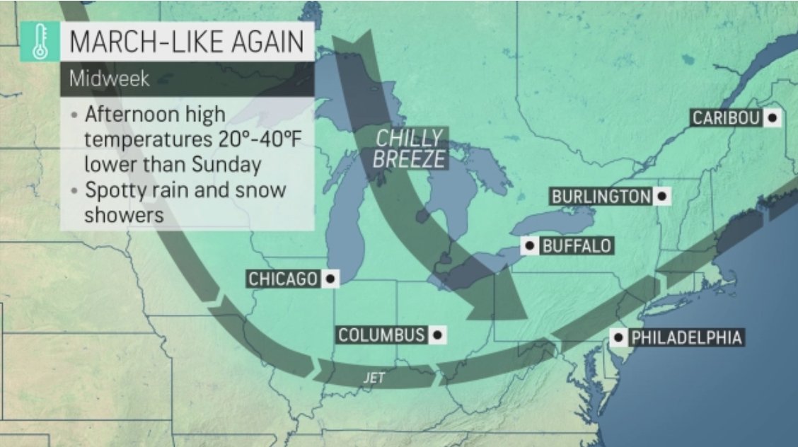
Frost warnings and overnight night snow hits southern Ontario
Digital Writers
The Weather Network
Tuesday, April 26th 2022, 7:38 am - Spring will hit the pause button Wednesday as temperatures plunge below zero and the threat for frost and snow creeps in.
Southern Ontario has taken a step back into March-like weather territory, with a sharp temperature plummet that was accompanied by snow flurries and a frost threat that will last into Thursday morning. Those in frost-prone areas are urged to cover up plants. However, conditions will improve for the end of the week, thanks to a blocking pattern in Eastern Canada. Several days of sunshine lies ahead for southern Ontario, continuing through the weekend. More on the major temperature dip and what's coming, below.
MID-WEEK: TEMPERATURES TUMBLE, WITH THREAT FOR SNOW AND FROST
A trough brought in much cooler air Tuesday, with a quick burst of Arctic air pushing into the lower Great Lakes region, sending temperatures plummeting. This prompted Environment and Climate Change Canada (ECCC) to issue a frost advisory for the City of Toronto, Niagara and the Windsor-Essex regions.

"Cover up plants, especially those in frost-prone areas. Take preventative measures to protect frost-sensitive plants and trees," ECCC says in the advisory, adding that the threat for frost will persist Wednesday night into Thursday, as well.
In addition to the frost, as rain showers moved out of southern Ontario, a band of scattered flurries made its way into the region Tuesday evening from southern Lake Huron, pushing into the western Greater Toronto Area (GTA), Golden Horseshoe and Niagara in the overnight hours.
Another band of flurries will push in Wednesday morning from northern Lake Huron shores, eventually petering out in the afternoon.

Temperatures could be up to 10°C below seasonal on Wednesday, taking us back to March-like weather. Daytime highs stuck in the low single digits, hovering close to the freezing mark in many areas. In fact, the streak of below-seasonal air will put parts of southern Ontario on par with the regions closer to the Arctic Circle. Kincardine, for example, can expect a high of just 0°C on Wednesday.
Beyond Wednesday, Ontario's weather will be locked into a more pleasant ridging pattern with sunshine, but it's not enough to pump temperatures into seasonal or above seasonal territory.
The colder northerly air moving in will keep temperatures cool and below seasonal for the days ahead. An easterly wind will develop off Lake Ontario this weekend, holding temperatures back a few degrees around the west end of Lake Ontario, including the GTA.

Several days of sunshine for southern Ontario will continue through the weekend.
This spell of below-seasonal conditions looks to continue through the beginning of May, with no signs of consistent warmth locking in any time soon.
The Weather Network - Frost warnings and overnight night snow hits southern Ontario
Digital Writers
The Weather Network
Tuesday, April 26th 2022, 7:38 am - Spring will hit the pause button Wednesday as temperatures plunge below zero and the threat for frost and snow creeps in.
Southern Ontario has taken a step back into March-like weather territory, with a sharp temperature plummet that was accompanied by snow flurries and a frost threat that will last into Thursday morning. Those in frost-prone areas are urged to cover up plants. However, conditions will improve for the end of the week, thanks to a blocking pattern in Eastern Canada. Several days of sunshine lies ahead for southern Ontario, continuing through the weekend. More on the major temperature dip and what's coming, below.
MID-WEEK: TEMPERATURES TUMBLE, WITH THREAT FOR SNOW AND FROST
A trough brought in much cooler air Tuesday, with a quick burst of Arctic air pushing into the lower Great Lakes region, sending temperatures plummeting. This prompted Environment and Climate Change Canada (ECCC) to issue a frost advisory for the City of Toronto, Niagara and the Windsor-Essex regions.
"Cover up plants, especially those in frost-prone areas. Take preventative measures to protect frost-sensitive plants and trees," ECCC says in the advisory, adding that the threat for frost will persist Wednesday night into Thursday, as well.
In addition to the frost, as rain showers moved out of southern Ontario, a band of scattered flurries made its way into the region Tuesday evening from southern Lake Huron, pushing into the western Greater Toronto Area (GTA), Golden Horseshoe and Niagara in the overnight hours.
Another band of flurries will push in Wednesday morning from northern Lake Huron shores, eventually petering out in the afternoon.
Temperatures could be up to 10°C below seasonal on Wednesday, taking us back to March-like weather. Daytime highs stuck in the low single digits, hovering close to the freezing mark in many areas. In fact, the streak of below-seasonal air will put parts of southern Ontario on par with the regions closer to the Arctic Circle. Kincardine, for example, can expect a high of just 0°C on Wednesday.
Beyond Wednesday, Ontario's weather will be locked into a more pleasant ridging pattern with sunshine, but it's not enough to pump temperatures into seasonal or above seasonal territory.
The colder northerly air moving in will keep temperatures cool and below seasonal for the days ahead. An easterly wind will develop off Lake Ontario this weekend, holding temperatures back a few degrees around the west end of Lake Ontario, including the GTA.
Several days of sunshine for southern Ontario will continue through the weekend.
This spell of below-seasonal conditions looks to continue through the beginning of May, with no signs of consistent warmth locking in any time soon.
The Weather Network - Frost warnings and overnight night snow hits southern Ontario

northern watch
TB Fanatic
From my email inbox The Old Farmers Almanac

northern watch
TB Fanatic
From what I am seeing, Spring is a lot colder than last year.
jed turtle
a brother in the Lord
Thanks everyone for keeping this thread going! I try to read it everyday. The weather is the bottom line for most everyone as it involves everything and everyone. Even if most of them don’t realize it. Yet...
from my perspective the COSMOS is not pleased with most of the humans/us . Change of focus and attitude is required. More focus on the gardens And next year’s wood supply, less goofing off, (prime offender, here...)...
don’t forget Helen’s repeated warnings about fire mitigation. It takes a lot of effort to rake the leaves away from the buildings and properly dispose /compost them.
spring does seem colder. My dad here in Maine always used to caution against planting the corn before May 15, or even June 1. The season is short up here, so we only get one shot at it.
northern watch
TB Fanatic
northern watch
TB Fanatic
Thanks everyone for keeping this thread going! I try to read it everyday. The weather is the bottom line for most everyone as it involves everything and everyone. Even if most of them don’t realize it. Yet...
from my perspective the COSMOS is not pleased with most of the humans/us . Change of focus and attitude is required. More focus on the gardens And next year’s wood supply, less goofing off, (prime offender, here...)...
don’t forget Helen’s repeated warnings about fire mitigation. It takes a lot of effort to rake the leaves away from the buildings and properly dispose /compost them.
spring does seem colder. My dad here in Maine always used to caution against planting the corn before May 15, or even June 1. The season is short up here, so we only get one shot at it.
spring does seem colder. My dad here in Maine always used to caution against planting the corn before May 15, or even June 1. The season is short up here, so we only get one shot at it. - very true
TheSearcher
Are you sure about that?
Adapt 2030 has some videos releasing today about "Food Forests" that have been interesting. I don't have the time to cut-n-paste on my phone right now, but I thought y’all should be aware of them.
Martinhouse
Deceased
These newest videos from Adapt 2030 are part 1 of 3 and part 2 of 3. I think I'll wait. Most likely he'll post the last (all three in one) tonight or tomorrow. I like listening to the whole interview at the same time, maybe over a long lunch break or while I'm busy with a sit-down type of chore.
Thanks for the reminder...I'd forgotten to check his site this afternoon.
Thanks for the reminder...I'd forgotten to check his site this afternoon.
alpha
Veteran Member
Posted on TB2K report-food-grocery-shortages-price-increases-here-2022-edition
Farm Crisis Hits Dakotas As Floods Delay Plantings, May Trigger US Food Shortage
It would appear that Mother Nature has joined the chorus...
Farm Crisis Hits Dakotas As Floods Delay Plantings, May Trigger US Food Shortage
It would appear that Mother Nature has joined the chorus...
Martinhouse
Deceased
I just saw that part three of that Adapt 2030 interview that we mentioned here earlier today in posts #4890 and #4891 is now posted. I'm assuming it will also be posted as one long interview tomorrow. Hope it's a good one!
TxGal
Day by day
I just saw that part three of that Adapt 2030 interview that we mentioned here earlier today in posts #4890 and #4891 is now posted. I'm assuming it will also be posted as one long interview tomorrow. Hope it's a good one!
I'll try to remember to check for it in the morning, and post it when he has it up. Thanks, Martinhouse!
We're working like crazy on the garden and have been transplanting off-shoots of our thornless blackberry bushes that so kindly have been popping up near the mother bush. Free berry bushes! A few months ago I wanted to get some more (Arapaho is one), but my gosh the garden centers had them for like $25.00 this year - about twice the cost from last year as I recall. I lucked out and got one at Aldi's for $5.99, and it's growing nicely. Free is just so nice :-)
We have about one week before our daily highs are forecasted to jump into the mid-90s. We're trying to get as much done before then as possible. Although, our tomato plants aren't happy with highs in the 70s.
alpha
Veteran Member
Electroverse
 Articles Crop Loss Extreme Weather GSM
Wintry Blasts To Lash Australia; Temps Across Antarctica Remain Below Average; + Ukraine Planting Woes Persist
April 28, 2022 Cap Allon
Wintry Blasts To Lash Australia
Wet wintry weather will sweep much of Australia’s southeast states over the weekend as an Antarctic front moves in.
“Winds will increase around this front, with the possibility of damaging wind gusts across elevated parts of Tasmania, Victoria and southern alpine NSW,” said BoM meteorologist Miriam Bradley.
The front will bring icy temperatures with lows around 3C on the cards for many Thursday through Sunday.
In Western Australia, the mercury has already begun to plummet with Perth suffering temps 8C below the seasonal average.
Looking further ahead, though, something far more impressive could be building as we enter the month of May.
An expansive polar front is currently on course to engulf the majority of the Aussie beginning May 4:
 GFS 2m Temperature Anomalies (C) May 4 – May 7 [tropicaltidbits.com].
A dusting of snow could also be on the cards.
Stay tuned for updates.
Temps Across Antarctica Remain Below Average
Inconveniently for the AGW Party (not that they’ll ever address it), since that entirely natural atmospheric river event of March 18 temperatures across Antarctica have been holding BELOW the multidecadal average.
According to data from the Climate Change Institute at the University of Maine (which runs hot btw), today, April 28, the mercury at the bottom of the world is holding -3.8C below the 1979-2000 base (also note that global temp stands at an anomaly of just 0.1C):

We’ve now seen a month and a half of below-average temps across Antarctica. This fits the overall cooling trend witnessed across the continent in recent years — the South pole suffered its coldest ‘coreless winter’ (April-Sept) in recorded history last year. TPTB and their MSM lapdogs can disinform the compliant masses all they want, but it doesn’t change the facts.
And in line with the persistent freeze of the past few years, the Antarctic ice sheet has been EXPANDING, continuing the trend of growth witnessed over the past 4+ decades (the satellite era).
Sea ice around the continent rebounded sharply in 2020 and 2021 to the levels of some 3-decades ago. This rebound is visualized in the chart below, as is the multidecadal expansion which stands at approximately 1% per decade:

Official data also reveals that East Antarctica, which covers two thirds of the continent, has cooled 2.8C over the past 40-odd years, with West Antarctica cooling 1.6C. It stands that only a tiny slither of Antarctica (the Antarctic Peninsula) has seen any warming –statistically insignificant warming, at that– but there are no prizes for guessing which region the MSM focuses on.
Ukraine Planting Woes Persist
According to the latest update from the country’s agriculture ministry, Ukraine’s spring sowing campaign continued to pick up speed with progress advancing by another 570,000 hectares, or 3.4%, between April 21-25, amounting to around 25% of the forecast for spring crops.
However, planting problems are persisting across the country, particularly in eastern fields where land mines have been laid.
Ukraine’s minister of agrarian policy and food, Mykola Solsky, outlines some of the issues:
“Part of the land will not be sown due to unexploded bombs, mines and debris in the ground. Everyone is working, from the central government to farmers and villagers, who themselves identify the coordinates and pass them on to sappers so that they have less work to do,” the minister said, referring to military personnel tasked with clearing the land minds.
Although planting is picking up, it is still far behind schedule. And although a recent government announcement has increased its overall spring sowing estimates to 75%, other industry forecasts have pegged that figure at well-under 50% — this, of course, will send ripples across the rest of the planet — Ukraine and Russia supply 30% of the world’s grain.
The country traditionally starts spring field work in late February or in March but this year’s record-cold spring delayed that significantly–not to mention the disruption caused by the invasion. Back in mid-March, Ukraine President Volodymyr Zelenskiy urged farmers to plant as many fields as possible. And although the planting situation in Ukraine remains dire, Solsky remains stoic (at least publicly): “The main thing is that this process is underway and no one has given up.”
However, the reality is visible across the country’s supermarket shelves, in both shortages and spiraling prices.
Solsky is warning that logistics and supply chain issues are continuing to mount, along with cripplingly-high fuel prices and fertilizer shortages: “We bring it, the channels have narrowed, the demand exceeds the supply — these are the logical consequences of standard market laws,” Solsky explained.
And finally, North America is suffering its own planting woes with sowing significantly down due to cold weather, late-spring snow, drought, and fertilizer shortages — and prices continue to climb.
Added to pricing pressures comes the news that Indonesia has broadened its export ban on raw materials for cooking oil to fight food inflation. As a result, U.S. soyoil futures surged to a record high on Wednesday.
“The move dramatically tightens an already tight global supply of edible oils that saw global prices surge when the Russian invasion of Ukraine took Ukrainian sunflower oil supplies off the market,” StoneX chief commodities economist Arlan Suderman wrote in a client note.
Corn futures also rallied, with the most-active contract hitting its highest in a decade as the weather outlook showed little relief from the cold and wet weather that was keeping growers around the U.S. Midwest out of the fields.
The latest forecast threatened to push corn planting past the ideal window in many areas of the Midwest, which will likely cause harvest prospects to drop significantly at a time when grain supplies were already tight due to the breadbaskets of the world all facing issues simultaneously (U.S., Canada, Ukraine, Russia, Argentina, Brazil, and most recently Kazakhstan).
“We can’t lose acres and we can’t lose yield,” said John Zanker, market analyst at Risk Management Commodities in Indiana.
The Rockefellers, World Bank, IMF And WEF All Warn Of A “Massive Global Food Crisis”
The world faces a “human catastrophe” from a food crisis. The elites are broadcasting warnings. Heed them.
And in related news, U.S. natural gas futures 5% Wednesday on expectations liquefied natural gas (LNG) will remain near record highs for months to come, after Russia halted gas supplies to Bulgaria and Poland after the nation’s rejected its demand for payment in rubles.
U.S. prices also rose on forecasts of higher-than-expected domestic gas demand over the next two weeks, as well as a continued drop in U.S. output due to a late-season cold snap that froze oil and gas wells in North Dakota.
Everywhere you turn the system is crumbling.
Prepare.
Confluence Of Catastrophes: The Next Great Depression Could Be Just Months Away

Prepare NOW.
The COLD TIMES are returning, the mid-latitudes are REFREEZING in line with historically low solar activity, cloud-nucleating Cosmic Rays, and a meridional jet stream flow (among many other forcings, including the impending release of the Beaufort Gyre). Prepare accordingly — learn the facts, relocate if need be, and grow your own.
Wintry Blasts To Lash Australia; Temps Across Antarctica Remain Below Average; + Ukraine Planting Woes Persist
April 28, 2022 Cap Allon
Wintry Blasts To Lash Australia
Wet wintry weather will sweep much of Australia’s southeast states over the weekend as an Antarctic front moves in.
“Winds will increase around this front, with the possibility of damaging wind gusts across elevated parts of Tasmania, Victoria and southern alpine NSW,” said BoM meteorologist Miriam Bradley.
The front will bring icy temperatures with lows around 3C on the cards for many Thursday through Sunday.
In Western Australia, the mercury has already begun to plummet with Perth suffering temps 8C below the seasonal average.
Looking further ahead, though, something far more impressive could be building as we enter the month of May.
An expansive polar front is currently on course to engulf the majority of the Aussie beginning May 4:
 GFS 2m Temperature Anomalies (C) May 4 – May 7 [tropicaltidbits.com].
A dusting of snow could also be on the cards.
Stay tuned for updates.
Temps Across Antarctica Remain Below Average
Inconveniently for the AGW Party (not that they’ll ever address it), since that entirely natural atmospheric river event of March 18 temperatures across Antarctica have been holding BELOW the multidecadal average.
According to data from the Climate Change Institute at the University of Maine (which runs hot btw), today, April 28, the mercury at the bottom of the world is holding -3.8C below the 1979-2000 base (also note that global temp stands at an anomaly of just 0.1C):

We’ve now seen a month and a half of below-average temps across Antarctica. This fits the overall cooling trend witnessed across the continent in recent years — the South pole suffered its coldest ‘coreless winter’ (April-Sept) in recorded history last year. TPTB and their MSM lapdogs can disinform the compliant masses all they want, but it doesn’t change the facts.
And in line with the persistent freeze of the past few years, the Antarctic ice sheet has been EXPANDING, continuing the trend of growth witnessed over the past 4+ decades (the satellite era).
Sea ice around the continent rebounded sharply in 2020 and 2021 to the levels of some 3-decades ago. This rebound is visualized in the chart below, as is the multidecadal expansion which stands at approximately 1% per decade:

Official data also reveals that East Antarctica, which covers two thirds of the continent, has cooled 2.8C over the past 40-odd years, with West Antarctica cooling 1.6C. It stands that only a tiny slither of Antarctica (the Antarctic Peninsula) has seen any warming –statistically insignificant warming, at that– but there are no prizes for guessing which region the MSM focuses on.
Ukraine Planting Woes Persist
According to the latest update from the country’s agriculture ministry, Ukraine’s spring sowing campaign continued to pick up speed with progress advancing by another 570,000 hectares, or 3.4%, between April 21-25, amounting to around 25% of the forecast for spring crops.
However, planting problems are persisting across the country, particularly in eastern fields where land mines have been laid.
Ukraine’s minister of agrarian policy and food, Mykola Solsky, outlines some of the issues:
“Part of the land will not be sown due to unexploded bombs, mines and debris in the ground. Everyone is working, from the central government to farmers and villagers, who themselves identify the coordinates and pass them on to sappers so that they have less work to do,” the minister said, referring to military personnel tasked with clearing the land minds.
Although planting is picking up, it is still far behind schedule. And although a recent government announcement has increased its overall spring sowing estimates to 75%, other industry forecasts have pegged that figure at well-under 50% — this, of course, will send ripples across the rest of the planet — Ukraine and Russia supply 30% of the world’s grain.
The country traditionally starts spring field work in late February or in March but this year’s record-cold spring delayed that significantly–not to mention the disruption caused by the invasion. Back in mid-March, Ukraine President Volodymyr Zelenskiy urged farmers to plant as many fields as possible. And although the planting situation in Ukraine remains dire, Solsky remains stoic (at least publicly): “The main thing is that this process is underway and no one has given up.”
However, the reality is visible across the country’s supermarket shelves, in both shortages and spiraling prices.
Solsky is warning that logistics and supply chain issues are continuing to mount, along with cripplingly-high fuel prices and fertilizer shortages: “We bring it, the channels have narrowed, the demand exceeds the supply — these are the logical consequences of standard market laws,” Solsky explained.
And finally, North America is suffering its own planting woes with sowing significantly down due to cold weather, late-spring snow, drought, and fertilizer shortages — and prices continue to climb.
Added to pricing pressures comes the news that Indonesia has broadened its export ban on raw materials for cooking oil to fight food inflation. As a result, U.S. soyoil futures surged to a record high on Wednesday.
“The move dramatically tightens an already tight global supply of edible oils that saw global prices surge when the Russian invasion of Ukraine took Ukrainian sunflower oil supplies off the market,” StoneX chief commodities economist Arlan Suderman wrote in a client note.
Corn futures also rallied, with the most-active contract hitting its highest in a decade as the weather outlook showed little relief from the cold and wet weather that was keeping growers around the U.S. Midwest out of the fields.
The latest forecast threatened to push corn planting past the ideal window in many areas of the Midwest, which will likely cause harvest prospects to drop significantly at a time when grain supplies were already tight due to the breadbaskets of the world all facing issues simultaneously (U.S., Canada, Ukraine, Russia, Argentina, Brazil, and most recently Kazakhstan).
“We can’t lose acres and we can’t lose yield,” said John Zanker, market analyst at Risk Management Commodities in Indiana.
The Rockefellers, World Bank, IMF And WEF All Warn Of A “Massive Global Food Crisis”
The world faces a “human catastrophe” from a food crisis. The elites are broadcasting warnings. Heed them.
And in related news, U.S. natural gas futures 5% Wednesday on expectations liquefied natural gas (LNG) will remain near record highs for months to come, after Russia halted gas supplies to Bulgaria and Poland after the nation’s rejected its demand for payment in rubles.
U.S. prices also rose on forecasts of higher-than-expected domestic gas demand over the next two weeks, as well as a continued drop in U.S. output due to a late-season cold snap that froze oil and gas wells in North Dakota.
Everywhere you turn the system is crumbling.
Prepare.
Confluence Of Catastrophes: The Next Great Depression Could Be Just Months Away
Prepare NOW.
The COLD TIMES are returning, the mid-latitudes are REFREEZING in line with historically low solar activity, cloud-nucleating Cosmic Rays, and a meridional jet stream flow (among many other forcings, including the impending release of the Beaufort Gyre). Prepare accordingly — learn the facts, relocate if need be, and grow your own.
Cacheman
Ultra MAGA!
I don't know why he's making such a misleading statement as what's highlighted in blue. I know for a fact April 11 is the EARLIEST corn can be planted in that area and be covered by insurance, any earlier and the risk is on the grower. The LATEST the crop in that area can be planted to have full insurance coverage is May 31. The optimum planting date is dictated now by soil temperature and moisture. In general, look to plant corn once soil temperatures have risen above 50F and are expected to continue to rise. Generally Iowa doesn't see reduced yields until planting has been pushed into the last week of May. As for harvesting large amounts of corn in September, it really doesn't happen as the moisture content is still quite high and Soybeans are ready to harvest. The corn usually harvested before very late September is stored as high moisture grain in silos for cattle feed but even that is limited. Lot's of fear mongering in that one.
TheSearcher
Are you sure about that?
The info sent to him said that the farmer was hoping to get seeds planted early, and not only has that not happened, the farmer felt that the situation was not going to improve soon. Based on that farmer's plans, the economic damage is real, as they were hoping to recover losses and now can not. For at least that farmer, they have a real problem.I don't know why he's making such a misleading statement as what's highlighted in blue. I know for a fact April 11 is the EARLIEST corn can be planted in that area and be covered by insurance, any earlier and the risk is on the grower. The LATEST the crop in that area can be planted to have full insurance coverage is May 31. The optimum planting date is dictated now by soil temperature and moisture. In general, look to plant corn once soil temperatures have risen above 50F and are expected to continue to rise. Generally Iowa doesn't see reduced yields until planting has been pushed into the last week of May. As for harvesting large amounts of corn in September, it really doesn't happen as the moisture content is still quite high and Soybeans are ready to harvest. The corn usually harvested before very late September is stored as high moisture grain in silos for cattle feed but even that is limited. Lot's of fear mongering in that one.
IAF was pointing out that the knock-on effect is that this is not the only testimony he is receiving, and that global crop losses need to be offset by big gains more locally. Those gains aren't likely to happen because the early plantings aren't happening. Not a lot fear needs mongering in light of that.
Last edited:
Martinhouse
Deceased
I just listened to all three parts of the above mentioned interview on Adapt 2030. The guest guy lives in Florida and he's part of a company that will consult with clients to help plan a "food forest" designed for the client's particular property.
I didn't find it especially helpful and wish I had not spent an hour and a half listening to it.
-----
Did a little shopping this morning.....just a bit more of my normal panic buying. (: (: I got ten boxes of regular size canning lids but was watching my last few dollars. Too much month left at the end of the money this time. Next Tuesday is Social Security day for me so maybe I'll get more lids then if they are still in stock.
TxGal
Day by day
I just listened to all three parts of the above mentioned interview on Adapt 2030. The guest guy lives in Florida and he's part of a company that will consult with clients to help plan a "food forest" designed for the client's particular property.
I didn't find it especially helpful and wish I had not spent an hour and a half listening to it.
-----
Did a little shopping this morning.....just a bit more of my normal panic buying. (: (: I got ten boxes of regular size canning lids but was watching my last few dollars. Too much month left at the end of the money this time. Next Tuesday is Social Security day for me so maybe I'll get more lids then if they are still in stock.
I guess it's probably not worth posting the entire thing here, then :-)
I'm noticing not much left in the vegetable seeds area in some stores down here....some have removed their displays. Fortunately we ordered and received ours months ago. It just shows how many more people are buying seeds, I guess. I've been a fair supply of canning supplies here, including lids. Prices are way up, though.
TheSearcher
Are you sure about that?
I just listened to all three parts of the above mentioned interview on Adapt 2030. The guest guy lives in Florida and he's part of a company that will consult with clients to help plan a "food forest" designed for the client's particular property.
I didn't find it especially helpful and wish I had not spent an hour and a half listening to it.
-----
Did a little shopping this morning.....just a bit more of my normal panic buying. (: (: I got ten boxes of regular size canning lids but was watching my last few dollars. Too much month left at the end of the money this time. Next Tuesday is Social Security day for me so maybe I'll get more lids then if they are still in stock.
It was interesting, but not detail-oriented.


Martinhouse
Deceased
TxGal, I just now read this above latest from Ice Age Farmer. Rather disturbing, isn't it?
TxGal
Day by day
It really is! Our weather has been cooler, our tomatoes aren't doing too well. We watch a farmer about an hour from here with huge acreage plots on either side of the highway. Right now, one does not appear to be planted at all, which is very unusual. The others have crops up a few inches...can't tell yet if it's corn or sorghum.TxGal, I just now read this above latest from Ice Age Farmer. Rather disturbing, isn't it?
Martinhouse
Deceased
TxGal, Ice Age Farmer just added another section to his Telegram post about the grain crops
TxGal
Day by day
TxGal, Ice Age Farmer just added another section to his Telegram post about the grain crops
Thanks, Martinhouse, we literaly just got back inside after working outside in the garden/pastures since late afternoon.
Here's his post:

northern watch
TB Fanatic
Corn and Soybeans Near Record Prices, Push Food Costs Higher; Ukraine war, drought in South America and biofuel demand pressure supplies of the crops
Thursday, April 28, 2022, 3:21 PM ET
By Ryan Dezember
Wall Street Journal
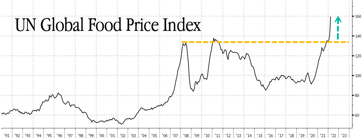
Corn and soybeans prices have risen nearly to records, signaling higher food inflation to come.
Global food prices had already reached records when Russia invaded Ukraine in late February and jeopardized big slices of the world’s grain and oilseed supplies. Poor harvests in South America, inclement planting weather in the U.S. and rising biofuel demand threaten to stretch inventories even thinner and push prices higher.
The price of soybeans, which are fed to cows, chicken and salmon and crushed into oils, has gained 26% so far this year. Futures are trading above $17 a bushel for the first time since a hot, dry summer baked American farms and ruined crops in 2012. Until recently, that drought a decade ago was the only time that corn cost more than $8 a bushel. Corn futures, up 37% this year, traded as high as $8.24 on Thursday, about 15 cents shy of the all-time high.
If corn and soybeans notch new highs, they will be the latest raw materials to do so in the broadest and sharpest commodities rally of the modern trading era. Vegetable oils, oats and wheat already reached records in 2022.
Corn is more than twice as expensive as before the pandemic and in most years without drought. Soybeans have nearly doubled their typical price, too.
The rise in these key ingredients is spilling over into the cost of producing foods ranging from pork chops to Pepsi, eating away at Americans’ purchasing power and adding another challenge to the postpandemic economic recovery.
Food companies say shoppers have so far kept up. But analysts say there are signs, such as stronger private-label sales, that show consumers are responding to the pinch.
“The elasticities that we’re having in the business are better than historical and better than what we had planned,” PepsiCo Inc. Chief Executive Ramon Laguarta told investors on a call this week. “However, we think the consumer is very early in this process of adjusting to the new inflationary environment.”
U.S. food prices in March were up 8.8% from a year earlier, according to the Bureau of Labor Statistics. A United Nations group said global food prices hit a new high last month, and the World Bank said it expects war in Europe to boost food prices about 23% this year, after a 31% climb in 2021 when snarled supply chains and bad weather jolted agricultural commodity markets.
The Federal Reserve responded last month with its first interest-rate increase in more than three years, lifting the benchmark rate to a range between 0.25% and 0.5% and penciling in additional hikes. Many expect the central bank to raise rates another half-percentage point next week.
The Biden administration doesn’t anticipate food shortages at home and is directing aid abroad to places that might run low, White House press secretary Jen Psaki said Tuesday.
“We’re really conducting extensive diplomacy to encourage all countries to refrain from export restrictions and excessive stockpiling,” she said. “It would exacerbate supply-chain challenges and price inflation.”
Ukraine is a major corn exporter, and there are doubts that much will be planted amid the fighting, or that bushels will make it to international markets following harvest. The U.S. Agriculture Department has lowered its projections for Ukraine’s corn exports by about 30% since Russia invaded.
Soybean gains have been driven lately by Brazil’s severe drought and record temperatures, which threaten to shrink the biggest bean grower’s crop.
Drought is a worry in North America, too, because of the La Niña weather pattern. But currently it is cold, wet weather that is delaying planting in the Midwest. Just 7% of this year’s corn was planted by the start of the week, compared with 16% a year ago, the Agriculture Department said. Soybeans are similarly behind schedule.
This year is expected to be just the third on record in which U.S. farmers plant more land with soybeans than with corn. Soaring fertilizer prices are behind the shift. Legumes fix nitrogen in the soil and don’t need the nutrient added like corn does.
BofA Securities analysts say one way to boost food supplies would be for governments to cut rules mandating that biofuels made from crops be blended into gasoline and diesel.
The Biden administration eased summer smog rules to allow higher blends of corn-made ethanol, an effort to tame prices at the pump. Oil producers, environmental groups and meat companies that feed their animals corn were displeased.
The analysts forecast the U.S. will use about five times as much corn to make motor fuels this year than Ukraine typically exports in total.
“For wealthy countries, the pressure on food supply created by biofuel blending may seem tolerable, but lower-income countries would realize greater food inflation relief from even small reductions in blending,” the BofA analysts wrote in a research note last week.
Write to Ryan Dezember at ryan.dezember@wsj.com
Corn and Soybeans Near Record Prices, Push Food Costs Higher - WSJ
Thursday, April 28, 2022, 3:21 PM ET
By Ryan Dezember
Wall Street Journal
Corn and soybeans prices have risen nearly to records, signaling higher food inflation to come.
Global food prices had already reached records when Russia invaded Ukraine in late February and jeopardized big slices of the world’s grain and oilseed supplies. Poor harvests in South America, inclement planting weather in the U.S. and rising biofuel demand threaten to stretch inventories even thinner and push prices higher.
The price of soybeans, which are fed to cows, chicken and salmon and crushed into oils, has gained 26% so far this year. Futures are trading above $17 a bushel for the first time since a hot, dry summer baked American farms and ruined crops in 2012. Until recently, that drought a decade ago was the only time that corn cost more than $8 a bushel. Corn futures, up 37% this year, traded as high as $8.24 on Thursday, about 15 cents shy of the all-time high.
If corn and soybeans notch new highs, they will be the latest raw materials to do so in the broadest and sharpest commodities rally of the modern trading era. Vegetable oils, oats and wheat already reached records in 2022.
Corn is more than twice as expensive as before the pandemic and in most years without drought. Soybeans have nearly doubled their typical price, too.
The rise in these key ingredients is spilling over into the cost of producing foods ranging from pork chops to Pepsi, eating away at Americans’ purchasing power and adding another challenge to the postpandemic economic recovery.
Food companies say shoppers have so far kept up. But analysts say there are signs, such as stronger private-label sales, that show consumers are responding to the pinch.
“The elasticities that we’re having in the business are better than historical and better than what we had planned,” PepsiCo Inc. Chief Executive Ramon Laguarta told investors on a call this week. “However, we think the consumer is very early in this process of adjusting to the new inflationary environment.”
U.S. food prices in March were up 8.8% from a year earlier, according to the Bureau of Labor Statistics. A United Nations group said global food prices hit a new high last month, and the World Bank said it expects war in Europe to boost food prices about 23% this year, after a 31% climb in 2021 when snarled supply chains and bad weather jolted agricultural commodity markets.
The Federal Reserve responded last month with its first interest-rate increase in more than three years, lifting the benchmark rate to a range between 0.25% and 0.5% and penciling in additional hikes. Many expect the central bank to raise rates another half-percentage point next week.
The Biden administration doesn’t anticipate food shortages at home and is directing aid abroad to places that might run low, White House press secretary Jen Psaki said Tuesday.
“We’re really conducting extensive diplomacy to encourage all countries to refrain from export restrictions and excessive stockpiling,” she said. “It would exacerbate supply-chain challenges and price inflation.”
Ukraine is a major corn exporter, and there are doubts that much will be planted amid the fighting, or that bushels will make it to international markets following harvest. The U.S. Agriculture Department has lowered its projections for Ukraine’s corn exports by about 30% since Russia invaded.
Soybean gains have been driven lately by Brazil’s severe drought and record temperatures, which threaten to shrink the biggest bean grower’s crop.
Drought is a worry in North America, too, because of the La Niña weather pattern. But currently it is cold, wet weather that is delaying planting in the Midwest. Just 7% of this year’s corn was planted by the start of the week, compared with 16% a year ago, the Agriculture Department said. Soybeans are similarly behind schedule.
This year is expected to be just the third on record in which U.S. farmers plant more land with soybeans than with corn. Soaring fertilizer prices are behind the shift. Legumes fix nitrogen in the soil and don’t need the nutrient added like corn does.
BofA Securities analysts say one way to boost food supplies would be for governments to cut rules mandating that biofuels made from crops be blended into gasoline and diesel.
The Biden administration eased summer smog rules to allow higher blends of corn-made ethanol, an effort to tame prices at the pump. Oil producers, environmental groups and meat companies that feed their animals corn were displeased.
The analysts forecast the U.S. will use about five times as much corn to make motor fuels this year than Ukraine typically exports in total.
“For wealthy countries, the pressure on food supply created by biofuel blending may seem tolerable, but lower-income countries would realize greater food inflation relief from even small reductions in blending,” the BofA analysts wrote in a research note last week.
Write to Ryan Dezember at ryan.dezember@wsj.com
Corn and Soybeans Near Record Prices, Push Food Costs Higher - WSJ
Last edited:
northern watch
TB Fanatic
"We Are On The Precipice Of A Global Food Crisis," Goya Foods CEO Warns
BY TYLER DURDEN
THURSDAY, APR 28, 2022 - 09:00 PM
The effects of pandemic lockdowns, related supply chain strains, and conflict in Ukraine are wreaking havoc on the world's agricultural system. Readers have heard the likes of the UN warning that Middle Eastern countries are at "breaking points" as food prices hit record highs, and as of last week, the Rockefeller Foundation began the countdown (about six months) to a "massive, immediate food crisis."
Now, Goya Foods CEO Bob Unanue has issued a similar warning: "We are on the precipice of a global food crisis."
In a Wednesday interview, Unanue told Fox Business's Maria Bartiromo, "Americans will have to tighten their belts and consume less," in response to her question about a potential food shortage crisis.
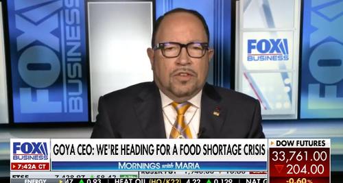
Bartiromo then asked a series of questions, such as "Do you think things will get worse?" and "Do you think food prices will go even higher later this year?"
He warned about an imbalance in world food production, indicating "farmers are paying double for fertilizer, they're planting less and yields will be less."
Unanue then spoke about "30% of the global wheat production in Ukraine goes unplanted." He said the "global food supply chain is a very tight balance. If we interrupt the food production, we will have a food crisis that will send prices through the roof."

He went on to say, "as a rich country, we can afford higher-priced food, but other countries won't be able to bear it," suggesting the US will be the last affected.
To the Unanue's point, the dominos are already beginning to fall as inflation riots have already sparked socio-economic turmoil in Sir Lanka and Peru. Countries across Africa and the Middle East, many of which are importers of food, are experiencing soaring prices and imminent shortages.
Unanue's interview is more proof the world's agricultural system is fracturing and storm clouds are gathering.
Watch the full interview here.
"We Are On The Precipice Of A Global Food Crisis," Goya Foods CEO Warns | ZeroHedge
BY TYLER DURDEN
THURSDAY, APR 28, 2022 - 09:00 PM
The effects of pandemic lockdowns, related supply chain strains, and conflict in Ukraine are wreaking havoc on the world's agricultural system. Readers have heard the likes of the UN warning that Middle Eastern countries are at "breaking points" as food prices hit record highs, and as of last week, the Rockefeller Foundation began the countdown (about six months) to a "massive, immediate food crisis."
Now, Goya Foods CEO Bob Unanue has issued a similar warning: "We are on the precipice of a global food crisis."
In a Wednesday interview, Unanue told Fox Business's Maria Bartiromo, "Americans will have to tighten their belts and consume less," in response to her question about a potential food shortage crisis.

Bartiromo then asked a series of questions, such as "Do you think things will get worse?" and "Do you think food prices will go even higher later this year?"
He warned about an imbalance in world food production, indicating "farmers are paying double for fertilizer, they're planting less and yields will be less."
Unanue then spoke about "30% of the global wheat production in Ukraine goes unplanted." He said the "global food supply chain is a very tight balance. If we interrupt the food production, we will have a food crisis that will send prices through the roof."
He went on to say, "as a rich country, we can afford higher-priced food, but other countries won't be able to bear it," suggesting the US will be the last affected.
To the Unanue's point, the dominos are already beginning to fall as inflation riots have already sparked socio-economic turmoil in Sir Lanka and Peru. Countries across Africa and the Middle East, many of which are importers of food, are experiencing soaring prices and imminent shortages.
Unanue's interview is more proof the world's agricultural system is fracturing and storm clouds are gathering.
Watch the full interview here.
"We Are On The Precipice Of A Global Food Crisis," Goya Foods CEO Warns | ZeroHedge
northern watch
TB Fanatic
northern watch
TB Fanatic
alpha
Veteran Member
Electroverse
 Crop Loss Extreme Weather GSM
Historic Freeze Returns To SE Asia; + Snow, Rain, Cold Keeps U.S. Farmers From Planting Corn, Yet America Continues To Sell To China
April 29, 2022 Cap Allon
Historic Freeze Returns To SE Asia
The first week-or-so of May will see another unusually frigid mass of polar cold sweep Southeast Asia.
The cold air is forecast to descend as far south as Vietnam, Laos and Thailand.
After recently breaking its low temperature record for April, Laos is expected to bust its record low for May, too.
 GFS 2m Temperature Anomalies (C) April 29 – May 1 [tropicaltidbits.com].
Also, shifting to South America, a cold front is advancing ‘up’ the continent with frost noted in Patagonia and also a remarkable -3.2C (26F) logged at San Antonio Oeste, Argentina. Temperatures will drop sharply as we enter the weekend, even at tropical latitudes — a chill that will threaten to further reduced already ropy-looking Argentinian and Brazilian crop estimates.
And I’ll conclude this brief southern hemisphere roundup with Australia where a fierce blast of polar cold is also on the cards as we enter early May:
Wintry Blasts To Lash Australia; Temps Across Antarctica Remain Below Average; + Ukraine Planting Woes Persist

Everywhere you turn the system is crumbling: Prepare.
Snow, Rain, Cold Keeps U.S. Farmers From Planting Corn
Late-season snow, heavy rains, and record cold are resulting in mounting planting delays across the U.S. (and Canada). “It’s just too cold for corn,” said Iowa farmer Kelly Nieuwenhuis, who farms 3,000 acres in O’Brien County.
Nationally, the planting pace is dragging, with only 7% of corn acreage and 3% of soybeans planted through April 24–less than half the acres planted at this time last year, reported the USDA–a gov agency tasked with stabilizing markets.
Focusing in on Iowa, America’s largest corn grower, this year is seeing the state’s slowest planting pace since 2013.
Adding to the planting pressures are global fertilizer, pesticide and herbicide shortages; and while I consider these inputs poisons, they are required by our modern, mono-cropping agricultural industry to achieve anything like decent yield: for every 1% decline in fertilizer usage there is a corresponding 1% decline in yield (with similar numbers for pesticides and herbicides).
Farmers already are complaining about fertilizer prices, which have jumped 300% or more due to supply chain concerns. In addition, the U.S. has imposed trade sanctions on Russia, a major exporter of fertilizers.
Nieuwenhui said some growers are worried about whether they’ll have fertilizer for next year’s growing season.
“It has everyone on edge,” he said. “They’re not sure how those supply chain issues will work out.”
Russia’s invasion of Ukraine (two agricultural powerhouses), combined with planting uncertainty elsewhere (including the U.S., Argentina, Brazil and Kazakhstan), is driving food prices higher and higher, globally. Ukraine is the world’s seventh-largest corn producer, eighth-largest wheat grower and the global leader in sunflowers — Ukraine and Russia combined provide approx. 30% of the total global grain supply, reductions here impact the entire world.
U.S. farmers have until early-May to plant corn before worries of lost yields begin being realized, with the window for soybeans extending until late May or early June.
“About the third week of May, you’re guaranteed to have some yield loss (on corn)”, said Mark Licht, an Iowa State University assistant agronomy professor. Then after that, Nieuwenhuis added: “People start to get nervous.”
May commences this weekend and the latest forecasts (shown below) are suggesting further delays.
Large swathes of the Midwest are expected to see severe cold and heavy rain over the next week, with Iowa expecting up to 1.5 inches of precipitation, according to Justin Glisan, the state climatologist.
Equally troublesome is Iowa’s soil temperature which is approx. 6F below average this month. It’s usually in the low to mid-50s this time of year, added Glisas, but this month looks like it will be among the top 10 coldest Aprils on record.
And May isn’t looking much better:
 GFS 2m Temperature Anomalies (C) April 28 – May 9 [tropicaltidbits.com].
Additional rounds of late-season snow are also on the cards for many:
 GFS Total Snowfall (inches) April 29 – May 15 [tropicaltidbits.com].
The Consumer Price Index climbed 8.5% in March, the largest increase since 1981. This was predominantly driven by energy and fuel rises, but spiraling food prices also had an impact with farm goods making up about 20% of every dollar spent at the grocery store.
Additionally, corn and soybeans are used to feed livestock, either directly or indirectly: higher grain prices = higher meat prices.
Yet while the risk of shortages mount…
…America Continues To Sell To China
Another 1.09 million mt of US corn has been sold to China –the fourth significant order this month– raising expectations that the Asian importer is turning to U.S. supply to help plug the loss of supply from Ukraine.
China has raced to the top of the global list of corn importers, and imported just under 8 million mt of Ukrainian corn in the 2021 calendar year, according to the Agricensus Export Dashboard. However, the Russian invasion has curtailed exports, with Ukraine’s major deep sea ports either blockaded or severely damaged, making it impossible to load the panamax vessels that typically ply that route.
The Chinese have been increasing their purchases each week through April.
“Old crop Ukrainian business was canceled. And they had to buy… one way or another,” said a trader.
Beside turning to U.S. corn, China has also opened its gates to corn imports from Myanmar, with the volume bought in March surging 640% versus the same point of last years.
“I suspect there will be additional purchases still to come… China has little coverage for June-Aug, as well as Sep-Jan. There is still a lot of work to be done… A storm is brewing and the world’s consumers need to wake up,” one broker said.
That shortage has also renewed rumors about the possibility that Brazilian corn could finally be allowed as an export option for China, perhaps even within the next month (pending strict GMO checks). However, given the delayed planting and poor yields mounting across South America, Brazil accepting any large order from China would, as they would re. the U.S., raise eyebrows; but as we see time and time again, nation’s are more than willing to risk their own domestic supply in order to fulfill contracts.
Historic Freeze Returns To SE Asia; + Snow, Rain, Cold Keeps U.S. Farmers From Planting Corn, Yet America Continues To Sell To China
April 29, 2022 Cap Allon
Historic Freeze Returns To SE Asia
The first week-or-so of May will see another unusually frigid mass of polar cold sweep Southeast Asia.
The cold air is forecast to descend as far south as Vietnam, Laos and Thailand.
After recently breaking its low temperature record for April, Laos is expected to bust its record low for May, too.
 GFS 2m Temperature Anomalies (C) April 29 – May 1 [tropicaltidbits.com].
Also, shifting to South America, a cold front is advancing ‘up’ the continent with frost noted in Patagonia and also a remarkable -3.2C (26F) logged at San Antonio Oeste, Argentina. Temperatures will drop sharply as we enter the weekend, even at tropical latitudes — a chill that will threaten to further reduced already ropy-looking Argentinian and Brazilian crop estimates.
And I’ll conclude this brief southern hemisphere roundup with Australia where a fierce blast of polar cold is also on the cards as we enter early May:
Wintry Blasts To Lash Australia; Temps Across Antarctica Remain Below Average; + Ukraine Planting Woes Persist
Everywhere you turn the system is crumbling: Prepare.
Snow, Rain, Cold Keeps U.S. Farmers From Planting Corn
Late-season snow, heavy rains, and record cold are resulting in mounting planting delays across the U.S. (and Canada). “It’s just too cold for corn,” said Iowa farmer Kelly Nieuwenhuis, who farms 3,000 acres in O’Brien County.
Nationally, the planting pace is dragging, with only 7% of corn acreage and 3% of soybeans planted through April 24–less than half the acres planted at this time last year, reported the USDA–a gov agency tasked with stabilizing markets.
Focusing in on Iowa, America’s largest corn grower, this year is seeing the state’s slowest planting pace since 2013.
Adding to the planting pressures are global fertilizer, pesticide and herbicide shortages; and while I consider these inputs poisons, they are required by our modern, mono-cropping agricultural industry to achieve anything like decent yield: for every 1% decline in fertilizer usage there is a corresponding 1% decline in yield (with similar numbers for pesticides and herbicides).
Farmers already are complaining about fertilizer prices, which have jumped 300% or more due to supply chain concerns. In addition, the U.S. has imposed trade sanctions on Russia, a major exporter of fertilizers.
Nieuwenhui said some growers are worried about whether they’ll have fertilizer for next year’s growing season.
“It has everyone on edge,” he said. “They’re not sure how those supply chain issues will work out.”
Russia’s invasion of Ukraine (two agricultural powerhouses), combined with planting uncertainty elsewhere (including the U.S., Argentina, Brazil and Kazakhstan), is driving food prices higher and higher, globally. Ukraine is the world’s seventh-largest corn producer, eighth-largest wheat grower and the global leader in sunflowers — Ukraine and Russia combined provide approx. 30% of the total global grain supply, reductions here impact the entire world.
U.S. farmers have until early-May to plant corn before worries of lost yields begin being realized, with the window for soybeans extending until late May or early June.
“About the third week of May, you’re guaranteed to have some yield loss (on corn)”, said Mark Licht, an Iowa State University assistant agronomy professor. Then after that, Nieuwenhuis added: “People start to get nervous.”
May commences this weekend and the latest forecasts (shown below) are suggesting further delays.
Large swathes of the Midwest are expected to see severe cold and heavy rain over the next week, with Iowa expecting up to 1.5 inches of precipitation, according to Justin Glisan, the state climatologist.
Equally troublesome is Iowa’s soil temperature which is approx. 6F below average this month. It’s usually in the low to mid-50s this time of year, added Glisas, but this month looks like it will be among the top 10 coldest Aprils on record.
And May isn’t looking much better:
 GFS 2m Temperature Anomalies (C) April 28 – May 9 [tropicaltidbits.com].
Additional rounds of late-season snow are also on the cards for many:
 GFS Total Snowfall (inches) April 29 – May 15 [tropicaltidbits.com].
The Consumer Price Index climbed 8.5% in March, the largest increase since 1981. This was predominantly driven by energy and fuel rises, but spiraling food prices also had an impact with farm goods making up about 20% of every dollar spent at the grocery store.
Additionally, corn and soybeans are used to feed livestock, either directly or indirectly: higher grain prices = higher meat prices.
Yet while the risk of shortages mount…
…America Continues To Sell To China
Another 1.09 million mt of US corn has been sold to China –the fourth significant order this month– raising expectations that the Asian importer is turning to U.S. supply to help plug the loss of supply from Ukraine.
China has raced to the top of the global list of corn importers, and imported just under 8 million mt of Ukrainian corn in the 2021 calendar year, according to the Agricensus Export Dashboard. However, the Russian invasion has curtailed exports, with Ukraine’s major deep sea ports either blockaded or severely damaged, making it impossible to load the panamax vessels that typically ply that route.
The Chinese have been increasing their purchases each week through April.
“Old crop Ukrainian business was canceled. And they had to buy… one way or another,” said a trader.
Beside turning to U.S. corn, China has also opened its gates to corn imports from Myanmar, with the volume bought in March surging 640% versus the same point of last years.
“I suspect there will be additional purchases still to come… China has little coverage for June-Aug, as well as Sep-Jan. There is still a lot of work to be done… A storm is brewing and the world’s consumers need to wake up,” one broker said.
That shortage has also renewed rumors about the possibility that Brazilian corn could finally be allowed as an export option for China, perhaps even within the next month (pending strict GMO checks). However, given the delayed planting and poor yields mounting across South America, Brazil accepting any large order from China would, as they would re. the U.S., raise eyebrows; but as we see time and time again, nation’s are more than willing to risk their own domestic supply in order to fulfill contracts.
northern watch
TB Fanatic

BenIan
Veteran Member
Ice Age Farmer
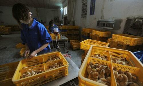
Wow: H5N1 bird flu confirmed in a Colorado man who had direct poultry exposure.
Remember we’ve just been warned H5N1 would be an apocalyptic “the real pandemic”:
Fmr CDC Director: Bird Flu is the Real Pandemic – C19 was just practice
— #BirdFlu did crossover in January in the UK as well:
UK: “Apocalyptic Bird Flu” Jumps to Humans as Authorities Cull Millions of Birds
Martinhouse
Deceased
TxGal, I just sent you a PM.
northern watch
TB Fanatic
China Reports 1st Ever Human Case Of H3N8 Bird Flu
BY TYLER DURDEN
ZERO HEDGE
THURSDAY, APR 28, 2022 - 11:20 PM
Authored by Dorothy Li via The Epoch Times (emphasis ours),
A boy in China has contracted the H3N8 strain of bird flu, which appears to be the first known human case in the world, said the Chinese regime’s health authorities.
Workers vaccinate chicks with the H9 bird flu vaccine at a farm in Changfeng county, Anhui province, China, on April 14, 2013. (Stringer/Reuters)
The case involved is a 4-year-old boy who had been hospitalized on April 10 in Zhumadian city in the central province of Henan, China’s health commission said in an April 26 statement.
No human (to human) infection of this strain has been reported, the agency added.
H3N8 is known to infect horses, seals, and dogs. It is one of the two strains that cause dog flu in the United States, according to the U.S. Centers for Disease Control and Prevention (CDC). It has been detected in dogs across much of the United States, CDC said on its website, adding it hasn’t infected a human.
The commission said that the chances of it spreading among people were low.
“This infection is an accidental cross-species transmission,” read the statement. “There is a low risk of large-scale transmission.”
Though rare, infections in humans can lead to adaptive mutations that potentially allow these viruses to more easily spread in mammals, said Erik Karlsson, deputy head of the virology unit at the Institut Pasteur in Cambodia.
Karlsson said the virus warranted expanded surveillance. He added its implication in the 1889 influenza pandemic, known as the Russian flu, was “a major concern for the risk of the virus.”
China’s commission said an initial assessment determined the variant is of avian origin. It noted there were chickens and crows raised in the boy’s home and that wild ducks were populated in the area.
His close contacts did not show any abnormalities during the medical surveillance period, it added.
The boy developed symptoms including a fever on April 5 and was diagnosed with H3N8 about two weeks later on April 24, according to the statement.
He is in critical condition, according to Hong Kong’s health department, citing a notification from Beijing. The National Health Commission did not mention this detail in the statement.
Last year, China reported a 41-year-old man contracted H10N3, which is also believed to be the first human infection of the type of avian influenza.
In 2021, China has reported 21 human infections with the H5N6 subtype of avian influenza to the World Health Organization (WHO). Though the numbers are much lower than the hundreds infected with H7N9 in 2017, infections leave many critically ill and have resulted in at least six deaths, raising concerns among experts.
“We need to be concerned about all spillover events,” Karlsson said.
Reuters contributed to this report.
China Reports 1st Ever Human Case Of H3N8 Bird Flu | ZeroHedge
BY TYLER DURDEN
ZERO HEDGE
THURSDAY, APR 28, 2022 - 11:20 PM
Authored by Dorothy Li via The Epoch Times (emphasis ours),
A boy in China has contracted the H3N8 strain of bird flu, which appears to be the first known human case in the world, said the Chinese regime’s health authorities.

Workers vaccinate chicks with the H9 bird flu vaccine at a farm in Changfeng county, Anhui province, China, on April 14, 2013. (Stringer/Reuters)
The case involved is a 4-year-old boy who had been hospitalized on April 10 in Zhumadian city in the central province of Henan, China’s health commission said in an April 26 statement.
No human (to human) infection of this strain has been reported, the agency added.
H3N8 is known to infect horses, seals, and dogs. It is one of the two strains that cause dog flu in the United States, according to the U.S. Centers for Disease Control and Prevention (CDC). It has been detected in dogs across much of the United States, CDC said on its website, adding it hasn’t infected a human.
The commission said that the chances of it spreading among people were low.
“This infection is an accidental cross-species transmission,” read the statement. “There is a low risk of large-scale transmission.”
Though rare, infections in humans can lead to adaptive mutations that potentially allow these viruses to more easily spread in mammals, said Erik Karlsson, deputy head of the virology unit at the Institut Pasteur in Cambodia.
Karlsson said the virus warranted expanded surveillance. He added its implication in the 1889 influenza pandemic, known as the Russian flu, was “a major concern for the risk of the virus.”
China’s commission said an initial assessment determined the variant is of avian origin. It noted there were chickens and crows raised in the boy’s home and that wild ducks were populated in the area.
His close contacts did not show any abnormalities during the medical surveillance period, it added.
The boy developed symptoms including a fever on April 5 and was diagnosed with H3N8 about two weeks later on April 24, according to the statement.
He is in critical condition, according to Hong Kong’s health department, citing a notification from Beijing. The National Health Commission did not mention this detail in the statement.
Last year, China reported a 41-year-old man contracted H10N3, which is also believed to be the first human infection of the type of avian influenza.
In 2021, China has reported 21 human infections with the H5N6 subtype of avian influenza to the World Health Organization (WHO). Though the numbers are much lower than the hundreds infected with H7N9 in 2017, infections leave many critically ill and have resulted in at least six deaths, raising concerns among experts.
“We need to be concerned about all spillover events,” Karlsson said.
Reuters contributed to this report.
China Reports 1st Ever Human Case Of H3N8 Bird Flu | ZeroHedge
northern watch
TB Fanatic
India
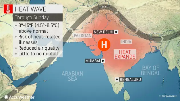
northern watch
TB Fanatic
northern watch
TB Fanatic
Brazil's Top Farmer To Slash Fertilizer Usage By 25% Amid Shortage
BY TYLER DURDEN
ZERO HEDGE
FRIDAY, APR 29, 2022 - 03:30 PM
Soaring prices for industrial fertilizer have forced one of Brazil's largest farmers to initiate plans to reduce nutrient spreading on fields by at least a quarter in 2022-23, according to Bloomberg.
SLC Agricola SA, which manages soybeans, corn, and cotton fields in an area larger than the state of Delaware, will reduce the use of fertilizer by 20% and 25%, Chief Executive Officer Aurelio Pavinato said.
Pavinato's planned reduction of fertilizer comes as prices have soared to record highs due to shortages stemming from the Russian invasion of Ukraine. He said fewer nutrients won't necessarily affect crop production yet.
SLC's decision to reduce fertilizer on fields is a prime example of how farmers worldwide are coping with high prices and shortages. Some farmers are switching to crops that need less fertilizer.
Even though Pavinato doesn't think harvests will be affected in the near term. The prospect of lower yields is a significant concern among ag traders and continues to push global food prices to record highs.

CBoT trader Tommy Grisafi (also risk advisor at commodity trading firm Advance Trading Inc.) said, "fertilizer supply issues will remain a problem for a few years and will soon result in declining yield production of crops in some of the world's top growing regions."
Grisafi warned: "It's not if, it's when."
The news from Brazil is very alarming because 80% of the country's farmland is very reliant on fertilizers, and more than 85% of its fertilizer is imported from abroad (susceptible to disruptions).
Brazil is also a top ag exporter of coffee, sugar, soybeans, manioc, rice, maize, cotton, edible beans, and wheat. If future harvests decline because of less fertilizer usage, this could then exacerbate the global food crisis that the Rockefeller Foundation expects to hit "in the next six months."
It might be a perfect time to plant a garden and become more independent as cracks in the global food supply chain emerge.
Brazil's Top Farmer To Slash Fertilizer Usage By 25% Amid Shortage | ZeroHedge
BY TYLER DURDEN
ZERO HEDGE
FRIDAY, APR 29, 2022 - 03:30 PM
Soaring prices for industrial fertilizer have forced one of Brazil's largest farmers to initiate plans to reduce nutrient spreading on fields by at least a quarter in 2022-23, according to Bloomberg.
SLC Agricola SA, which manages soybeans, corn, and cotton fields in an area larger than the state of Delaware, will reduce the use of fertilizer by 20% and 25%, Chief Executive Officer Aurelio Pavinato said.
Pavinato's planned reduction of fertilizer comes as prices have soared to record highs due to shortages stemming from the Russian invasion of Ukraine. He said fewer nutrients won't necessarily affect crop production yet.
"It's possible to cut fertilizers in a year and have a null impact on production," he said in an interview, adding there are fertilizer reserves in the soil from previous seasons.
SLC's decision to reduce fertilizer on fields is a prime example of how farmers worldwide are coping with high prices and shortages. Some farmers are switching to crops that need less fertilizer.
Even though Pavinato doesn't think harvests will be affected in the near term. The prospect of lower yields is a significant concern among ag traders and continues to push global food prices to record highs.
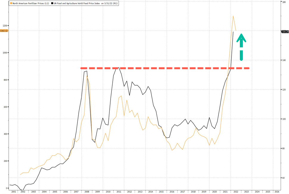
CBoT trader Tommy Grisafi (also risk advisor at commodity trading firm Advance Trading Inc.) said, "fertilizer supply issues will remain a problem for a few years and will soon result in declining yield production of crops in some of the world's top growing regions."
Grisafi warned: "It's not if, it's when."
The news from Brazil is very alarming because 80% of the country's farmland is very reliant on fertilizers, and more than 85% of its fertilizer is imported from abroad (susceptible to disruptions).
Brazil is also a top ag exporter of coffee, sugar, soybeans, manioc, rice, maize, cotton, edible beans, and wheat. If future harvests decline because of less fertilizer usage, this could then exacerbate the global food crisis that the Rockefeller Foundation expects to hit "in the next six months."
It might be a perfect time to plant a garden and become more independent as cracks in the global food supply chain emerge.
Brazil's Top Farmer To Slash Fertilizer Usage By 25% Amid Shortage | ZeroHedge
TxGal
Day by day
Well, I haven't post anything from The Oppenheimer Ranch Project in a while...here's one:
Karymsky Volcano Erupts To 33,000ft - Cold Records Tumble - The North Pole Moon Fraud - Sonic Boom - YouTube
Karymsky Volcano Erupts To 33,000ft - Cold Records Tumble - The North Pole Moon Fraud - Sonic Boom
6,295 views
Premiered Apr 28, 2022
View: https://youtu.be/E0n00I1621g
Run time is 10:05
Synopsis provided:
Spring storm to bring heavy snow to SW Montana https://bit.ly/3kmOWwI
Record-low temps to start the day Thursday https://bit.ly/38zq1D9
Unofficial Record Lows For Last 24hrs http://coolwx.com/record/usamovie.day...
Iowa cities see record-low temperatures on freezing Tuesday morning https://bit.ly/3EVdGW9
Storms possible Thursday; severe weather risk upgraded for Friday https://bit.ly/3EX0zno
Extremely Critical Fire Weather; Severe Storms in the Plains https://www.weather.gov/
GFS Model US http://bit.ly/3aHgjLQ
Worldwide Volcano News https://bit.ly/3y58XgJ
Karymsky volcano, Kamchatka: news https://bit.ly/3vnnbKE
The Karymsky volcano erupting, blanketing a snowy landscape in ash. https://bit.ly/3F0MOUS
3 Day Geomagnetic and Aurora Forecast https://www.solarham.net/geo_forecast...
NASA confirms loud noise heard by Mississippians was a meteor https://bit.ly/3MBbgyG
Viral North Pole Moon Video Is Extremely Fake https://bit.ly/3koGxJ8
Karymsky Volcano Erupts To 33,000ft - Cold Records Tumble - The North Pole Moon Fraud - Sonic Boom - YouTube
Karymsky Volcano Erupts To 33,000ft - Cold Records Tumble - The North Pole Moon Fraud - Sonic Boom
6,295 views
Premiered Apr 28, 2022
Run time is 10:05
Synopsis provided:
Spring storm to bring heavy snow to SW Montana https://bit.ly/3kmOWwI
Record-low temps to start the day Thursday https://bit.ly/38zq1D9
Unofficial Record Lows For Last 24hrs http://coolwx.com/record/usamovie.day...
Iowa cities see record-low temperatures on freezing Tuesday morning https://bit.ly/3EVdGW9
Storms possible Thursday; severe weather risk upgraded for Friday https://bit.ly/3EX0zno
Extremely Critical Fire Weather; Severe Storms in the Plains https://www.weather.gov/
GFS Model US http://bit.ly/3aHgjLQ
Worldwide Volcano News https://bit.ly/3y58XgJ
Karymsky volcano, Kamchatka: news https://bit.ly/3vnnbKE
The Karymsky volcano erupting, blanketing a snowy landscape in ash. https://bit.ly/3F0MOUS
3 Day Geomagnetic and Aurora Forecast https://www.solarham.net/geo_forecast...
NASA confirms loud noise heard by Mississippians was a meteor https://bit.ly/3MBbgyG
Viral North Pole Moon Video Is Extremely Fake https://bit.ly/3koGxJ8
TxGal
Day by day
Another from Oppenheimer (note he has a segment in this podcast about the Atlantic Meridional Current being very weak):
PNW Volcano Uptick - Extreme Critical Fire Conditions - Geomagnetic Forecast - ESA Big Announcement - YouTube
PNW Volcano Uptick - Extreme Critical Fire Conditions - Geomagnetic Forecast - ESA Big Announcement
4,413 views
Premiered 17 hours ago
View: https://youtu.be/v8BMLmAgx4E
Run time is 14:52
Synopsis provided:
Storm Threatens Plains as Northeast below-average temperatures https://fxn.ws/3xXelF8
Extremely critical fire conditions return to the Southwest and tornadoes threaten the Central Plains https://cnn.it/3vWiLt0
Hail reported in overnight storms in Kansas https://bit.ly/3rXNQvy
Insurance companies report uptick in calls following Tuesday night's hailstorm https://bit.ly/372Ndtk
Extremely Critical Fire Weather; Severe Storms and Flooding in the Plains https://www.weather.gov/
GFS Model US https://www.tropicaltidbits.com/analy...
Pacific Northwest Seismic Center https://pnsn.org/volcanoes
3 Day Geomagnetic and Aurora Forecast https://www.solarham.net/geo_forecast...
‘One of the worst invasive species on earth’ found in western Washington https://bit.ly/39sm6Zu
Hiker snaps ‘ghost-like figure’ on mountain and it turns out to be rare phenomenon https://bit.ly/3LCoGdK
Total Lunar Eclipse Will Bring Full Super Flower Blood Moon To Colorado In May https://cbsloc.al/3vWI2DL
May 15–16, 2022 Total Lunar Eclipse (Blood Moon) https://bit.ly/3Kt2sJM
A Major Ocean Current Is at Its Weakest Point in 1,000 Years https://bit.ly/39g4Giu
Current Atlantic Meridional Overturning Circulation weakest in last millennium https://go.nature.com/3kqyXxx
Lost Maya City Inside Volcano Crater Explored by Archaeologists https://bit.ly/3MHHxns
Sharp pictures! James Webb Space Telescope completes alignment in huge milestone https://bit.ly/3OF3w0e
New theory explains mystery behind fast magnetic reconnection https://bit.ly/37MS5TS
First-principles theory of the rate of magnetic reconnection in magnetospheric and solar plasmas https://www.nature.com/articles/s4200...
Astronomers Are About to Make a Massive Announcement About Something in The Milky Way https://bit.ly/38yMrVe
PNW Volcano Uptick - Extreme Critical Fire Conditions - Geomagnetic Forecast - ESA Big Announcement - YouTube
PNW Volcano Uptick - Extreme Critical Fire Conditions - Geomagnetic Forecast - ESA Big Announcement
4,413 views
Premiered 17 hours ago
Run time is 14:52
Synopsis provided:
Storm Threatens Plains as Northeast below-average temperatures https://fxn.ws/3xXelF8
Extremely critical fire conditions return to the Southwest and tornadoes threaten the Central Plains https://cnn.it/3vWiLt0
Hail reported in overnight storms in Kansas https://bit.ly/3rXNQvy
Insurance companies report uptick in calls following Tuesday night's hailstorm https://bit.ly/372Ndtk
Extremely Critical Fire Weather; Severe Storms and Flooding in the Plains https://www.weather.gov/
GFS Model US https://www.tropicaltidbits.com/analy...
Pacific Northwest Seismic Center https://pnsn.org/volcanoes
3 Day Geomagnetic and Aurora Forecast https://www.solarham.net/geo_forecast...
‘One of the worst invasive species on earth’ found in western Washington https://bit.ly/39sm6Zu
Hiker snaps ‘ghost-like figure’ on mountain and it turns out to be rare phenomenon https://bit.ly/3LCoGdK
Total Lunar Eclipse Will Bring Full Super Flower Blood Moon To Colorado In May https://cbsloc.al/3vWI2DL
May 15–16, 2022 Total Lunar Eclipse (Blood Moon) https://bit.ly/3Kt2sJM
A Major Ocean Current Is at Its Weakest Point in 1,000 Years https://bit.ly/39g4Giu
Current Atlantic Meridional Overturning Circulation weakest in last millennium https://go.nature.com/3kqyXxx
Lost Maya City Inside Volcano Crater Explored by Archaeologists https://bit.ly/3MHHxns
Sharp pictures! James Webb Space Telescope completes alignment in huge milestone https://bit.ly/3OF3w0e
New theory explains mystery behind fast magnetic reconnection https://bit.ly/37MS5TS
First-principles theory of the rate of magnetic reconnection in magnetospheric and solar plasmas https://www.nature.com/articles/s4200...
Astronomers Are About to Make a Massive Announcement About Something in The Milky Way https://bit.ly/38yMrVe
nomifyle
TB Fanatic
Around here I don't see the weather colder than usual. But then what is usual. I always said if the temps got into the 90's in April we would be in for a long hot summer. Although its gotten into the mid 80's, thank God its not the 90's. But that will come soon enough. I am rationing the A/C this year, got to get some control on the electric bill.
Last edited: