California Megaflood: Lessons from a Forgotten Catastrophe
A 43-day storm that began in December 1861 put central and southern California underwater for up to six months, and it could happen again
By B. Lynn Ingram on January 1, 2013
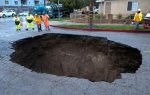
Credit: USGS.gov
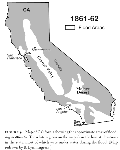
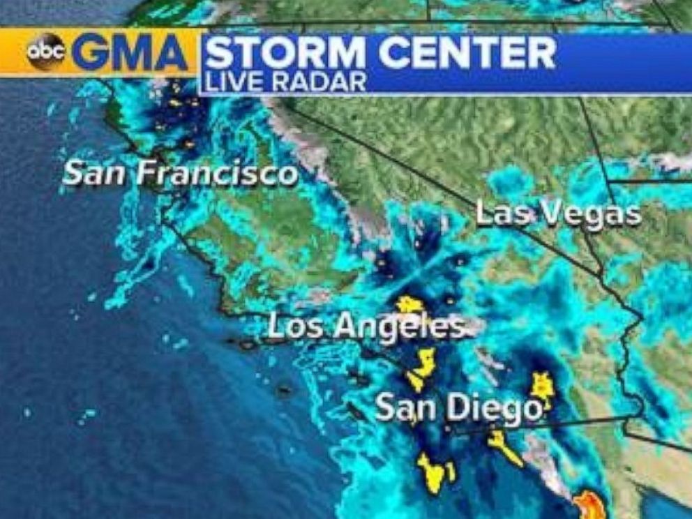
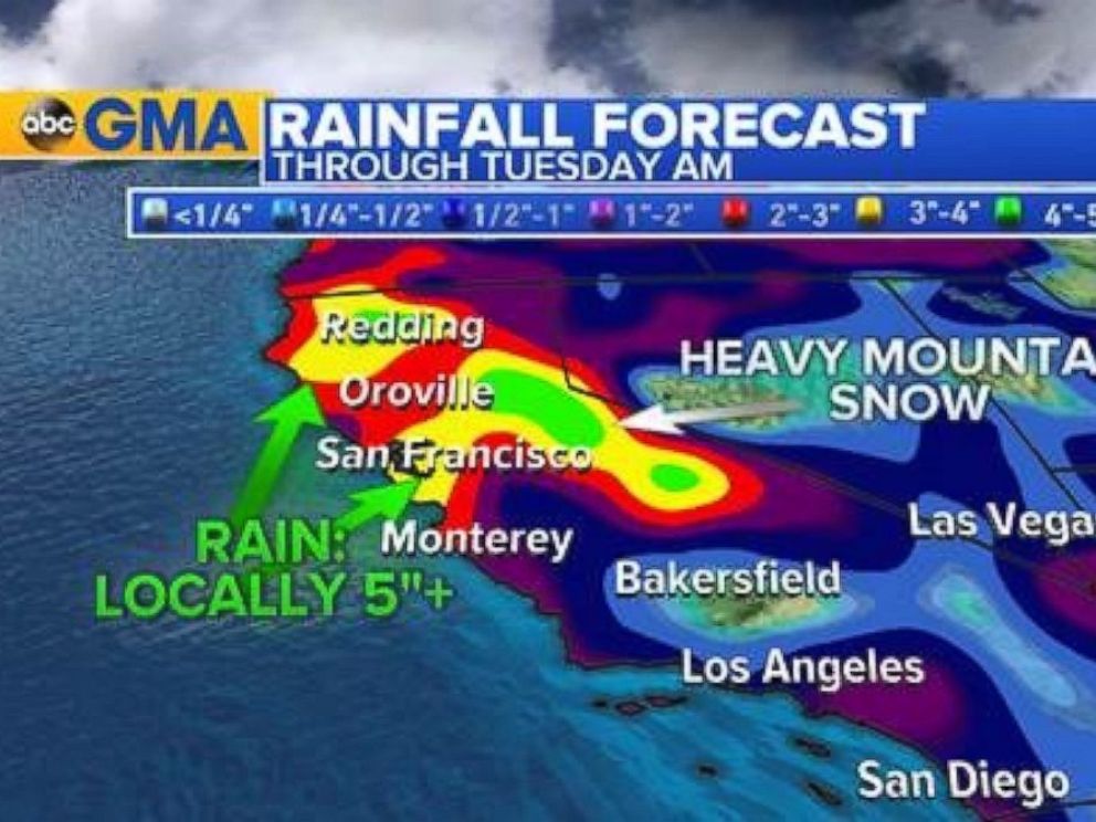
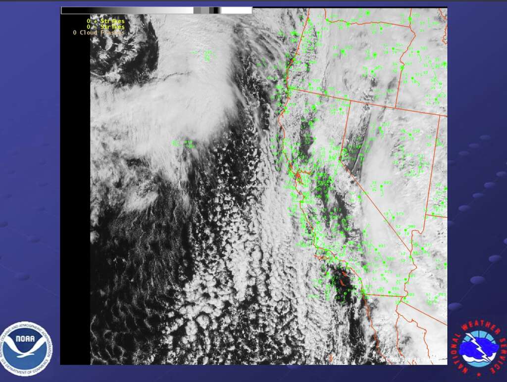
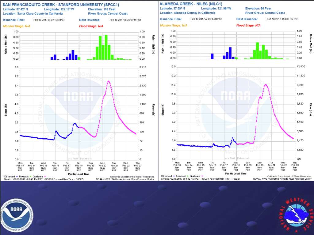
Geologic evidence shows that truly massive floods, caused by rainfall alone, have occurred in California every 100 to 200 years. Such floods are likely caused by atmospheric rivers: narrow bands of water vapor about a mile above the ocean that extend for thousands of kilometers.
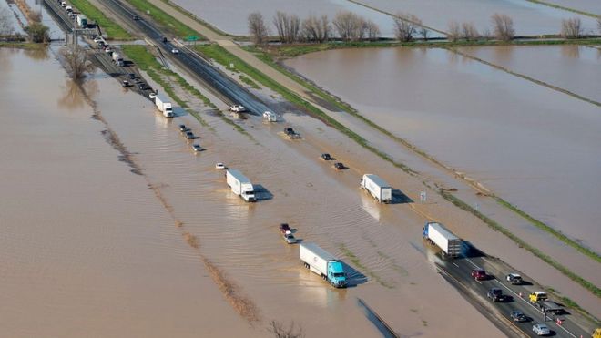
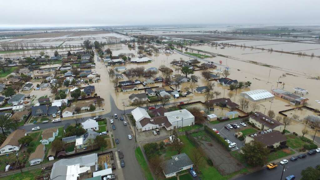
The atmospheric river storms featured in a January 2013 article in Scientific American that I co-wrote with Michael Dettinger, The Coming Megafloods, are responsible for most of the largest historical floods in many western states. The only megaflood to strike the American West in recent history occurred during the winter of 1861-62. California bore the brunt of the damage. This disaster turned enormous regions of the state into inland seas for months, and took thousands of human lives.
The costs were devastating: one quarter of California’s economy was destroyed, forcing the state into bankruptcy.
Today, the same regions that were submerged in 1861-62 are home to California’s fastest-growing cities. Although this flood is all but forgotten, important lessons from this catastrophe can be learned. Much of the insight can be gleaned from harrowing accounts in diary entries, letters and newspaper articles, as well as the book Up and Down California in 1860-1864, written by William Brewer, who surveyed the new state’s natural resources with state geologist Josiah Whitney.
In 1861, farmers and ranchers were praying for rain after two exceptionally dry decades. In December their prayers were answered with a vengeance, as a series of monstrous Pacific storms slammed—one after another—into the West coast of North America, from Mexico to Canada. The storms produced the most violent flooding residents had ever seen, before or since.
Sixty-six inches of rain fell in Los Angeles that year, more than four times the normal annual amount, causing rivers to surge over their banks, spreading muddy water for miles across the arid landscape. Large brown lakes formed on the normally dry plains between Los Angeles and the Pacific Ocean, even covering vast areas of the Mojave Desert. In and around Anaheim, , flooding of the Santa Ana River created an inland sea four feet deep, stretching up to four miles from the river and lasting four weeks.
Residents in northern California, where most of the state’s 500,000 people lived, were contending with devastation and suffering of their own. In early December, the Sierra Nevada experienced a series of cold arctic storms that dumped 10 to 15 feet of snow, and these were soon followed by warm atmospheric rivers storms. The series of warm storms swelled the rivers in the Sierra Nevada range so that they became raging torrents, sweeping away entire communities and mining settlements in the foothills—California’s famous “Gold Country.” A January 15, 1862, report from the Nelson Point Correspondence described the scene: “On Friday last, we were visited by the most destructive and devastating flood that has ever been the lot of ‘white’ men to see in this part of the country. Feather River reached the height of 9 feet more than was ever known by the ‘oldest inhabitant,’ carrying away bridges, camps, stores, saloon, restaurant, and much real-estate.” Drowning deaths occurred every day on the Feather, Yuba and American rivers. In one tragic account, an entire settlement of Chinese miners was drowned by floods on the Yuba River.
This enormous pulse of water from the rain flowed down the slopes and across the landscape, overwhelming streams and rivers, creating a huge inland sea in California’s enormous Central Valley—a region at least 300 miles long and 20 miles wide. Water covered farmlands and towns, drowning people, horses and cattle, and washing away houses, buildings, barns, fences and bridges. The water reached depths up to 30 feet, completely submerging telegraph poles that had just been installed between San Francisco and New York, causing transportation and communications to completely break down over much of the state for a month.
William Brewer wrote a series of letters to his brother on the east coast describing the surreal scenes of tragedy that he witnessed during his travels in the region that winter and spring. In a description dated January 31, 1862, Brewer wrote:
Thousands of farms are entirely under water—cattle starving and drowning. All the roads in the middle of the state are impassable; so all mails are cut off. The telegraph also does not work clear through. In the Sacramento Valley for some distance the tops of the poles are under water. The entire valley was a lake extending from the mountains on one side to the coast range hills on the other. Steamers ran back over the ranches fourteen miles from the river, carrying stock, etc, to the hills. Nearly every house and farm over this immense region is gone. America has never before seen such desolation by flood as this has been, and seldom has the Old World seen the like.
Brewer describes a great sheet of brown rippling water extending from the Coast Range to the Sierra Nevada. One-quarter of the state’s estimated 800,000 cattle drowned in the flood, marking the beginning of the end of the cattle-based ranchero society in California. One-third of the state’s property was destroyed, and one home in eight was destroyed completely or carried away by the floodwaters.
Sacramento, 100 miles up the Sacramento River from San Francisco, was (and still is) precariously located at the confluence of the Sacramento and American rivers. In 1861, the city was in many ways a hub: the young state’s sparkling new capital, an important commercial and agricultural center, and the terminus for stagecoaches, wagon trains, the pony express and riverboats from San Francisco. Although floods in Sacramento were not unknown to the residents, nothing could have prepared them for the series of deluges and massive flooding that engulfed the city that winter. The levees built to protect Sacramento from catastrophic floods crumbled under the force of the rising waters of the American River. In early January the floodwaters submerged the entire city under 10 feet of brown, debris-laden water. The water was so deep and dirty that no one dared to move about the city except by boat. The floodwaters caused immense destruction of property and loss of life.
California’s new Governor, Leland Stanford, was to be inaugurated on January 10, but the floodwaters swept through Sacramento that day, submerging the city.
Citizens fled by any means possible, yet the inauguration ceremony took place at the capital building anyway, despite the mounting catastrophe. Governor Stanford was forced to travel from his mansion to the capital building by rowboat. Following the expedited ceremony, with floodwaters rising at a rate of one foot per hour, Stanford rowed back to his mansion, where he was forced to steer his boat to a second story window in order to enter his home. Conditions did not improve in the following weeks. California’s legislature, unable to function in the submerged city, finally gave up and moved to San Francisco on January 22, to wait out the floods.
Sacramento remained underwater for months. Brewer visited the city on March 9, three months after the flooding began, and described the scene:
Such a desolate scene I hope to never see again. Most of the city is still under water, and has been there for three months. A part is out of the water, that is, the streets are above water, but every low place is full—cellars and yards are full, houses and walls wet, everything uncomfortable. No description that I can write will give you any adequate conception of the discomfort and wretchedness this must give rise to. I took a boat and two boys, and we rowed about for an hour or two. Houses, stores, stables, everything, were surrounded by water. Yards were ponds enclosed by dilapidated, muddy, slimy fences; household furniture, chairs, tables, sofas, the fragments of houses, were floating in the muddy waters or lodged in nooks and corners. I saw three sofas floating in different yards. The basements of the better class of houses were half full of water, and through the windows, one could see chairs, tables, bedsteads, etc., afloat. Through the windows of a schoolhouse I saw the benches and desks afloat. Over most of the city boats are still the only way of getting around.
The new Capital is far out in the water—the Governor’s house stands as in a lake—churches, public buildings, private buildings, everything, are wet or in the water. Not a road leading from the city is passable, business is at a dead standstill, everything looks forlorn and wretched. Many houses have partially toppled over; some have been carried from their foundations, several streets (now avenues of water) are blocked up with houses that have floated in them, dead animals lie about here and there—a dreadful picture. I don’t think the city will ever rise from the shock, I don’t see how it can.
The death and destruction of this flood caused such trauma that the city of Sacramento embarked on a long-term project of raising the downtown district by 10 to 15 feet in the seven years after the flood. Governor Stanford also raised his mansion from two to three stories, leaving empty the ground floor, to avoid damage from any future flooding events.
Downstream of Sacramento, towns and villages throughout the eastern San Francisco Bay Area were struggling with catastrophes of their own. Twenty miles northeast of San Francisco, four feet of water covered the entire town of Napa; to the east, the small town of Rio Vista on the Sacramento River was under six feet of water. The entire population of Alamo, at the foot of Mt. Diablo 50 miles east of San Francisco, was forced to flee rising floodwaters. People abandoned their homes in the middle of the night. Some found refuge, others drowned. The San Ramon Valley was one sheet of water from hill to hill as far as the eye could see. The destructive force of the floods was awesome: houses, otherwise intact and complete with their contents, were carried away in the rapids; horses, cattle, and barns were swept downstream for miles.
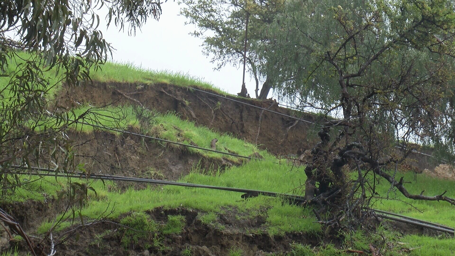
The heavy rains also triggered landslides and mud slides on California’s steep hillsides. For instance, in Knights Ferry and Mokelumne Hill, nearly every building was torn from its foundation and carried off by thundering landslides, and a major landslide also occurred at the town of Volcano in the Sierra foothills, killing seven people.
The 1861-62 floods extended far beyond the borders of California. They were the worst in recorded history over much of the American West, including northern Mexico, Oregon, Washington State and into British Columbia, as well as reaching inland into Nevada, Utah and Arizona. In Nevada, a normally arid state, twice its typical annual rainfall occurred in the two-month period of December 1861 to January 1862. All this excess water transformed the Carson Valley into a large lake, inundating Nevada City with nine feet of rain in 60 days.
In southern Utah, 1861-62 became known as the “year of the floods,” as homes, barns, a fiber and molasses mill and many forts were washed away, including the adobe home of a Mormon Bishop, John D. Lee. Lee had carefully recorded the weather throughout January 1862 in his diary, noting a solid period of alternating rain and snow with strong winds for most of that month. In Oregon, two and a half weeks of solid rain caused the worst flooding in this state’s history. Deluges covered huge portions of the lower Willamette Valley where Oregon City is located. Oregon City was the terminus of the Oregon Trail, and it was the state’s capital, where George Abernathy, an Oregon pioneer and the state’s first elected governor, lived and ran a thriving business. The flood destroyed his home, forcing him (and many others) to leave. Arizona was also impacted: floods occurred in the Gila, Verde, Bright Angel and Colorado River basins between January 19 and 23, 1862, and flooding was severe in Yuma, destroying the city.
Why so many people were caught off-guard by these floods remains a mystery, but clearly these immigrants did not recognize the climatic warning signs. They had never experienced such extreme flooding in the 12 years since the Gold Rush began, although lesser floods were not uncommon. It appears that the Native American populations, who had lived in the region for thousands of years, had deeper insights to the weather and hydrology, and recognized the patterns that result in devastating floods. A piece in the Nevada City Democrat described the Native American response on January 11, 1862:
We are informed that the Indians living in the vicinity of Marysville left their abodes a week or more ago for the foothills predicting an unprecedented overflow. They told the whites that the water would be higher than it has been for thirty years, and pointed high up on the trees and houses where it would come. The valley Indians have traditions that the water occasionally rises 15 or 20 feet higher than it has been at any time since the country was settled by whites, and as they live in the open air and watch closely all the weather indications, it is not improbable that they may have better means than the whites of anticipating a great storm.
The specific weather pattern that the Native Americans of the West recognized and knew would bring particularly severe flooding is once again understood today. The powerful storms originate in the warm and moist tropical Pacific Ocean. Recent research describes these storms more broadly as “atmospheric rivers,” and they often result in the worst floods in not only the American West, but across the globe.
The tragic 1861-62 floods may have temporarily served to wake-up the residents of California and the West to the possible perils of their region’s weather They saw nature at its most unpredictable and terrifying, turning in a day or an hour from benign to utterly destructive. But the costs to the state went beyond the loss of life, property and resources: California’s spirit and confidence was badly shaken.
The lessons of the 1861-62 floods should provide the impetus for flood disaster planning efforts in a region where housing developments and cities are spreading across many floodplains. A critical element of living in a place like California is an awareness of these natural disasters, which requires a deep understanding of the natural patterns and frequencies of these events. Today we have building codes for earthquake safety, but millions of new westerners are not aware of the region’s calamitous climate history. Most have never even heard of the 1861–62 floods, and those may not have been the worst that nature can regularly dish out to the region.
In a forthcoming book I co-wrote with Frances Malamud-Roam, THE WEST WITHOUT WATER: What Past Floods, Droughts, and Other Climatic Clues Tell Us About Tomorrow (University of California Press, Spring 2013) we present evidence for similar if not larger floods that have occurred every one to two centuries over the past two millennia in California, as well as nature’s flip-side: deep and prolonged droughts.
B. Lynn Ingram is a professor in the Earth and Planetary Science Department at the University of California, Berkeley. She studies past climatic and environmental change in California and other locations around the Pacific Rim.