
You are using an out of date browser. It may not display this or other websites correctly.
You should upgrade or use an alternative browser.
You should upgrade or use an alternative browser.
DISASTER Fast Fire and my daughter is stuck - UPDATE, post 156
- Thread starter SpokaneMan
- Start date
coloradohermit
Veteran Member
Adding prayers for all concerned and hoping for an update.
Lilbitsnana
On TB every waking moment

Lena Howland
@LenaHowland
·
44m
Here’s a look at what’s left of one property at 25390 Pine View Dr in Colfax in the #RiverFirearound 5:30am. Last update from Cal Fire said 35 to 40 structures were possibly damaged or destroyed by the fire. Next update expected at 7am.
@ABC10
34 sec
Lilbitsnana
On TB every waking moment
Lena Howland
@LenaHowland
·
16m
Very surreal seeing the damage from the #RiverFire in Colfax off the 25000 block of Pine View Drive. Homes in every direction on the end of this road have been reduced to rubble, power lines down and we’re still seeing active flames.
@ABC10


Lilbitsnana
On TB every waking moment
River Fire: Thousands in Nevada, Placer counties evacuated
Share

Updated: 7:22 AM PDT Aug 5, 2021
COLFAX, Calif. —
Thousands of residents in both Placer and Nevada counties were forced to evacuate Wednesday as a wildfire in the area grew to a threatening size, officials said.
Named the River Fire, it had burned at least 2,400 acres with no containment as of Thursday morning, Cal Fire said. The fire started around 2 p.m. Wednesday near Milk Ranch Road. The entire town of Colfax was told to evacuate Wednesday afternoon, along with the Bear River campground, as the fire took off up the river, spreading from Placer County into Nevada County.
Anywhere between 35-40 structures have been either damaged or destroyed, Cal Fire said in a Wednesday evening briefing.
Cal Fire said access is not a challenge, more so the spot fires that kept appearing Wednesday. Crews plan on aggressively attacking the fire overnight as it.
The fire was heading toward the direction of Highway 174 on Wednesday night.
EVACUATION ORDERS
Click here for a zone-to-zone breakdown of where current evacuations are
Placer County (2,400 people under evacuation order)
- The town of Colfax
- west of the railroad tracks to the Bear River, from Mt. Howell Road north to Rollins Lake
- Bear River Campground
- Milk Ranch Road to Tokayana Way
- North of Moorhaven Way from the Bear River to Placer Hills Road
- Placer Hills Road east to the Bear River
- Ben Taylor Road south along Placer Hills Road to Moorhaven Way
- East of Dog Bar Road
- South of Mount Olive Road
- West of Mountain Lion Road
- South of Greenhorn Access Road, west of Rollins Lake, north of the Bear River and east of Highway 174
Placer County
- State Route 174 at Lower Colfax Road and Bear River Bridge
- The on and off ramps for both directions of Interstate 80 at the State Route 174 separation and Canyon Way/Placer Hills Road
Nevada County
Evacuated residents can head to Bear River High School 11130 Magnolia Road in Grass Valley.
Placer County
There is a shelter at the Regional Park Gymnasium on 3770 Richardson Dr. in Auburn. Evacuated residents who have pets can go to the Auburn Veterans Memorial Hall at 100 East Street in Auburn.
ANIMAL SHELTERS
Nevada County
The Nevada County Fairgrounds has opened to accept animals evacuated from the fire.
This is a developing story.
California Wildfire Map & Tracker

 www.frontlinewildfire.com
California wildfires map
The most recent fire is the House fire, which started on Aug. 4. It is 20% contained and has burned 35 acres so far.
The largest active fire is the Dixie fire, which has burned 322,502 acres so far. It started on July 14 and is 35% contained.

 www.latimes.com
Live California Fire Map and Tracker | Frontline
Use this live California wildfire map and tracker to keep up to date on active California wildfires and fire activity across the state.
www.frontlinewildfire.com
California wildfires map
The most recent fire is the House fire, which started on Aug. 4. It is 20% contained and has burned 35 acres so far.
The largest active fire is the Dixie fire, which has burned 322,502 acres so far. It started on July 14 and is 35% contained.
California Fire Map: Active Wildfires
A map of wildfires currently burning in California
www.latimes.com
Lilbitsnana
On TB every waking moment

Scott Rodd
@SRodd_CPR
·
21m
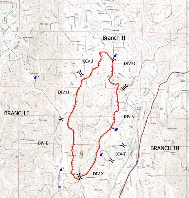
New on #RiverFire: About 5,200 evacuees, no expected repopulation of evac’d areas today. 3,400 structures are threatened, mostly residential. Cause of fire still under investigation. Fire front expected to be most active today in Div J and E on map below.

Lian Media
@LianMedia
·
20m
Grass Valley Air Attack 230 just took off from Nevada County airport and is making its first orbit to assess the River Fire. #RiverFire


Merci Merci Me
@OneMarzian
·
17m
Replying to
@girlsreallyrule
#DixieFire expanded by 70 miles last night. There is a new huge & uncontrolled fire that began in Colfax. The #RiverFire is burning out of control as I write this.
pinkelsteinsmom
Veteran Member
So sad.....I can't help but think there are groups of traitors doing this to us.
mzkitty
I give up.
So sad.....I can't help but think there are groups of traitors doing this to us.
If so, they need to be shot dead.

So sad.....I can't help but think there are groups of traitors doing this to us.
Meh. That Bear River fire started in a campground. All it takes is one idiot, and gawd knows, the world is full of 'em.
I just got off the phone with my friend. She said they have 14 air tankers on the job today (River Fire). They're fine so far...staying with the kids a little farther north.
babysteps
Veteran Member
Some of the fires are caused by idiots, and unfortunately, lots of them are caused by lightning. The traitors are the ones who refused for decades to manage the forests properly - but realistically, even if they had been, we'd still probably be seeing fires these last few years because of the drought. K Falls area has domestic wells drying up left and right. It's bad.
Does anyone have contact info for SpokaneMan? I'm very worried about him and his family.
Does anyone have contact info for SpokaneMan? I'm very worried about him and his family.
Siskiyoumom
Veteran Member
Greenville in its entirety is burned. Very horrific.
I'm guessing he has had to evacuate.Some of the fires are caused by idiots, and unfortunately, lots of them are caused by lightning. The traitors are the ones who refused for decades to manage the forests properly - but realistically, even if they had been, we'd still probably be seeing fires these last few years because of the drought. K Falls area has domestic wells drying up left and right. It's bad.
Does anyone have contact info for SpokaneMan? I'm very worried about him and his family.
babysteps
Veteran Member
I'm guessing he has had to evacuate.
I would certainly assume so, but cell phone? Email? When we had to evac from Beachie Creek last fall, all the evac centers had internet access and wifi set up.
More important things to do than post to a forum?I would certainly assume so, but cell phone? Email? When we had to evac from Beachie Creek last fall, all the evac centers had internet access and wifi set up.
So sad.....I can't help but think there are groups of traitors doing this to us.
Also, PG&E may be responsible for at least part of the Dixie fire; something about blown fuses and a downed tree. An employee working in the area called it in.Some of the fires are caused by idiots, and unfortunately, lots of them are caused by lightning. The traitors are the ones who refused for decades to manage the forests properly - but realistically, even if they had been, we'd still probably be seeing fires these last few years because of the drought. K Falls area has domestic wells drying up left and right. It's bad.
Does anyone have contact info for SpokaneMan? I'm very worried about him and his family.
I just spoke with cousin, about 10 minutes ago, at their home near Auburn on Sierra Estates Drive. They are safe for awhile. Their son and his family from Colfax had to evacuate to Auburn and my cousins home yesterday. They have no smoke there at the moment...seems wind has changed. She was talking so fast I had difficulty understanding her...I was attempting to ask specific questions but spent more time trying to calm her down, and letting them know we held them in prayer. However, they are all fine for now. Their son does not know yet if he has a home to go back to in Colfax. Pretty much touch and go... Cousin is preparing things to evacuate if need be.
Prayers for all board members, and all others who are affected by these fires... I can't imagine...
Prayers for all board members, and all others who are affected by these fires... I can't imagine...
Josie
Has No Life - Lives on TB
Exactly what I was thinking beyond the prayers for all those in the middle of this especially Spokanman and his dear daughter. Just an FYI...Cali recall election is scheduled for Sept. 14. Isn't northern California more red than blue?So sad.....I can't help but think there are groups of traitors doing this to us.
babysteps
Veteran Member
I'm sure you're right. Sorry. I was hoping maybe someone had off-forum contact and could reassure us.More important things to do than post to a forum?
medic38572
TB Fanatic
Wow I feel blessed.
pinkelsteinsmom
Veteran Member
Some here in Wa state have been caught throwing things out their car windows to start fires here.Also, PG&E may be responsible for at least part of the Dixie fire; something about blown fuses and a downed tree. An employee working in the area called it in.
danielboon
TB Fanatic
May the Lord grant safe passage to those in danger
Lilbitsnana
On TB every waking moment

Nevada County OES
@NevCoOES
·
18m
There are 4,298 Nevada County residents under a evacuation ORDER and 5,375 residents under an evacuation WARNING for the #RiverFire. Find info on evacuations at http://community.zonehaven.com and info on evacuation terms at http://readynevadacounty.org/2763/Understand-Evacuation-Terms….
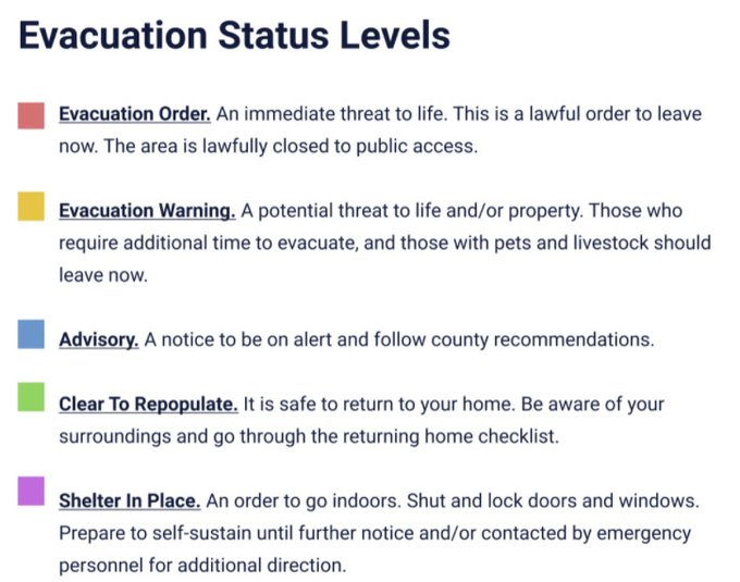
Understand Evacuation Terms
Learn these terms so you are ready to follow instructions from emergency managers.
Evacuation Order
An immediate threat to life. This is a lawful order to leave now. The area is lawfully closed to public access.
Evacuation Warning
A potential threat to life and/or property. Those who require additional time to evacuate, and those with pets and livestock should leave now.
Advisory
A notice to be on alert and follow county recommendations.
Clear To Repopulate
It is safe to return to your home. Be aware of your surroundings and go through the returning home checklist.
Shelter In Place
An order to go indoors. Shut and lock doors and windows. Prepare to self-sustain until further notice and/or contacted by emergency personnel for additional direction.
Normal
There is no current knowledge of threats affecting your area and that you can carry on with normal activity.
TRAFFIC CLOSURE LEVELS AND TERMS
Level 1: Open to emergency responders, critical resources (public works, utilities, animal rescue) and residents only.
Level 2: Closed to all traffic except emergency responders and critical resources.
Level 3: Closed to all traffic except emergency responders.
Level 4: Closed to all traffic due to potential hazard to life.
One-way Evacuation Operations: All the travel lanes on a designated section of road proceed in one direction, heading away from an approaching wildland fire. This provides a way to handle the additional traffic anticipated as residents and visitors leave the area in advance of a wildland fire.
BE AWARE
Be sure to obey officers’ directions and follow traffic cones and route markers. Message boards may be used to provide key information. Please follow instructions and remain calm. Stopping to talk to officers during an emergency is not recommended as it slows the evacuation process.
Understand Evacuation Terms | Nevada County, CA
Know how to go. Learn the evacuation terms and what they mean to you and your family.
 readynevadacounty.org
Exactly what I was thinking beyond the prayers for all those in the middle of this especially Spokanman and his dear daughter. Just an FYI...Cali recall election is scheduled for Sept. 14. Isn't northern California more red than blue?
Didn’t this happen in 2020, too? Or maybe 2016? I remember someone mentioning it.
Live Stream
8.05.21 - Dixie Fire - Grim Dawn - Battle for Chester - Greenville is Gone - Hell on Earth II
View: https://youtu.be/U2zmAYP1cOE
8.05.21 - Dixie Fire - Grim Dawn - Battle for Chester - Greenville is Gone - Hell on Earth II
dioptase
Veteran Member
Damn, just damn. Praying that they can quickly put a stop to these fires. Praying that nobody gets hurt or killed (homes lost is bad enough).
I saw that the fires are up by Lassen Volcanic NP, which DD and I visited when she was young. Damn. At the rate things are going, pretty soon there won't be any scenic (wooded) places left in this state!
(Far northern CA is mostly red, but Sacramento could be considered N. CA and I'd be very surprised if that and the surrounding area were not blue. (I can't tell from the map, but Sacramento county supposedly went for Biden.) )
I saw that the fires are up by Lassen Volcanic NP, which DD and I visited when she was young. Damn. At the rate things are going, pretty soon there won't be any scenic (wooded) places left in this state!
(Far northern CA is mostly red, but Sacramento could be considered N. CA and I'd be very surprised if that and the surrounding area were not blue.
(I can't tell from the map, but Sacramento county supposedly went for Biden.) )
Last edited:
mzkitty
I give up.
This is going to continue for another 2 weeks, according to something I read this morning.


View: https://twitter.com/RealMiBaWi/status/1423335939422801921
View: https://twitter.com/RealMiBaWi/status/1423335939422801921
adgal
Veteran Member
This is from the Paradise Fire (2018) - a dad and his sons trying to make it out. It's a very intense video - but it really gives you an idea about how terrifying these fires can be.

 gloria.tv
Paradise California Fire Dad, Kids & Pets Near Death Escape WARNING VERY INTENSE VIDEO Camp Fire Ca
Paradise California Fire Dad, Kids & Pets Near Death Escape WARNING VERY INTENSE VIDEO Camp Fire Ca. FAMILY IN MIDDLE OF CALIFORNIA FIRE...SCAPE FROM HELL
gloria.tv
SpokaneMan
Veteran Member
Thank you all so very much for your thoughts and prayers! We are safe. My daughter was caught in traffic on Highway 49 . So I got on the maps and had her take side roads until she cleared the traffic jam and made it back to Auburn safely. It was a long night for us all. Not exactly easy sleeping with fire creeping in your back yard. And for the record, we do reside in Auburn, CA. In fact I grew up on the Bear River where this fire started. It is looking like the investigation is gearing towards a homeless encampment on the long term Bear River Campground in Colfax, CA. It's a small town about 15 minutes north of me. Overnight, thankfully, the winds changed directions and starting blowing to the Northeast of us. It's still a very fluid situation however. Thankfully I taught them well, because the first thing both of my daughters did when they got home was update their BOB's.
I can attest to your prayers! Thank you again all!")
I can attest to your prayers! Thank you again all!
Sherrynboo
Veteran Member
So glad y'all are safe!
pauldingbabe
The Great Cat
Amen!