We are still evacuated. I received a response from Calaveras County Animal Services stating that they do not have the authority and are not coordinating getting people in the fire evacuation area to feed animals. They could send a animal services officer to my residence to check on them. My house is locked with security doors so I am so glad I did not give them my address or I am sure they would have been more than happy to break into my house. On the bright side the power is back on at my house. Please pray for me today as I am very upset at the whole situation with my kitties and the idiotic response from our county. I know for a fact they were escorting people on the other side of the county to their residences to retrieve/feed animals. Please forgive me for being so negative today.
Butte Fire update:
71,780 acres with 45% containment
Expected containment: September 24, 2015
Cause: Still under investigation
Personnel: 4,961
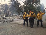
Structures lost: 408
September 16, 2015 at 7:34 AM
Control objectives again today are to keep the fire:
1. North of the Stanislaus River
2. South of Ridge, Sutter Creek Volcano, Pioneer Creek and Mill Creek Roads and the North Fork of the Mokelumne River
3. East of Highway 49
4. West of the Stanislaus National Forest DPA boundry
Weather and fire behavior forecast
Today will be the last day of the cooler weather and slightly increased humidity. The humidity will decrease from the day before, however there is still a slight chance of showers. Temperatures will be 63-70 degrees during the day and 46-53 degrees overnight. The minimum humidity will be 35-45% during the day and 55- 63% overnight. The winds will be south to southwest 6-10 mph with gusts to 13 mph in the valleys/slopes and 15-20 mph with gust to 30 mph on the ridges during the day. Winds overnight will continue to be from the southwest 10-15 mph with gust to 25 on the ridges and slightly less in the valleys and slopes, until midnight.
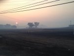
The fine fuels in the area were able to recover for most of the day on Tuesday, however by late afternoon they began to dry out. The skies will be clear in the morning increasing the drying on the fuels. The heavier fuels have had no recovery with the higher humidity and are available to burn. The potential for spot fires will increase when the fuels are exposed to the sun. Rates of spread and Probability of Ignition will continue to increase as the fuels continue to dry over the next 24-48 hours. This also has the potential for previous spot fires to become active.
The northeast portion of the fire, in the middle and south fork of the Mokelumne River, will once again have a southwest wind. This wind can blow embers across the line or across the canyon. Be aware of any flare ups of brush near the line or trees in the area of the line or on the ridges. The wind will be strong enough to carry embers 1 /3 to 3/4 of a mile. These embers may turn into spot fires as the humidity decreases. The east side of the fire also has the potential for spot fires as the wind will continue to blow across the line. The south and west portions of the fire will have less of a problem from spot fires in general but terrain can create eddies in the wind, directing it back across the line. Any spot fire will have a moderate to rapid rate of spread dependent on the fine dead fuel moisture. Remember the spread of this fire has been determined by the spotting ahead of the fire front.
Air operations will be limited until the smoke lifts out of the area, in the late morning or early afternoon.
September 16, 2015 at 7:15 AM
Minimal activity overnight.
http://yubanet.com/2015Local/ButteAEU.php
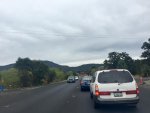
Evacuation listing from Cal fire as of September 16, 2015 7:00 am:
(Calaveras County) West Murray Creek/Murraydale Lane (entire street). Fricot City Road North of Sheep Ranch Road. Fricot City Road is closed 1 mile East of the intersection of Calaveritas Road and Fricot City Road. Fricot City Road is also closed in Sheep Ranch. The areas north along Sheep Ranch Road at Avery Sheep Ranch to the intersection of Morris Rd/Valley View Road. The entire area of Railroad Flat.
Hwy 26 in Mokelumne Hill at Italian Vista to West Point
all areas to include Glencoe, Westpoint and Wilseyville. Bald Mountain Road, Winton Road Blue Mountain Road, Mitchell Mill Road, Skunk Hollow Road.
Evacuations Advisory:
(Amador County) Canyon View, Fig Tree Lane, and Pondersosa Way; Tabeau Road south of Arrowhead to Amador Road, Ranch Drive and Aqueduct Grove Road. Hwy 88 from Ranch Road East to Tiger Creek Road (Red Corral and Buckhorn Areas).
***All previously mandatory evacuated areas being re-populated are still under evacuation advisory. The public is reminded that there are still emergency vehicles and personnel working in the area. Please use caution and remain alert to any changes in fire conditions***
(Calaveras County) The corridor along Hwy 49 from the Amador County Line south to the city limits of Angels Camp and all areas east of Hwy 49 that were previously released are now under an advisory. The areas southeast of Calaveritas Road to Costa Road. The areas along Fricot City Road along the southside to Sheep Ranch Road. The areas South of Avery Sheep Ranch Road to Morris Road in Avery. The town of Murphys, Forrest Meadows, Avery and along the Hwy 4 corridor from Avery to Arnold, including the town of Arnold.
http://cdfdata.fire.ca.gov/incidents/incidents_details_info?incident_id=1221