My big concern is Ian hasn’t really started to intensify yet. Ian was to peak early and be on the downside near landfall for many reasons. However, late start to the intensification process could mean stronger landfall.
Just something to keep your eye on with this storm.
If it’s not a hurricane by noon tomorrow then I change my opinion on this storm.
updated 3 hours ago
Tropical Storm Ian is about to undergo explosive intensification into a major hurricane in the western Caribbean Sea and Gulf of Mexico, a danger to the Cayman Islands, western Cuba and Florida in the coming days.
As Florida prepares for Ian, Florida Gov. Ron DeSantis
has declared a state of emergency for all 67 counties. This will make more resources available for storm preparation and will also activate members of the Florida National Guard to be put on standby ahead of Ian's arrival.
The National Hurricane Center issued a tropical storm watch for the lower Florida Keys Sunday evening. It is the first watch issued in the U.S.
The forecast has trended westward over the last day or so. There are aspects of the forecast in which we have more confidence, while others remain uncertain, which is typical for tropical forecasting this far out in time.
Here's a look at everything we know right now about Ian.
Latest Status
Tropical Storm Ian is located in the western Caribbean Sea and is beginning to make its long-anticipated turn toward the northwest.
It is producing some outer bands of showers with locally heavy rain wrapping into Jamaica.
Satellite And Location
(The icon shows the location of the system's center.)
First Look At Forecast Path
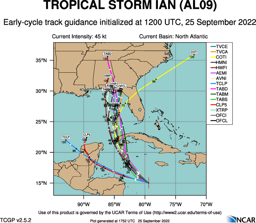
Here is the latest forecast path of Ian, according to the National Hurricane Center.
Ian will first track near the Cayman Islands, then western Cuba, then in the general direction either of the Florida Panhandle or Florida Peninsula.
Remember, impacts with any tropical storm or hurricane typically occur outside the cone and can arrive before the center.
Now, let's delve into more of the details with Ian's forecast and impacts.
Current Watches, Warnings and Caribbean Threats
A hurricane warning is in effect for Grand Cayman in the Cayman Islands, as well as for parts of western Cuba, as shown in the map below. This means hurricane conditions are expected, in this case by early Monday in Grand Cayman and by early Tuesday in western Cuba. Tropical storm conditions will arrive in those areas sooner, making preparations difficult.
A tropical storm warning is in effect for other parts of western and central Cuba, meaning tropical storm conditions are expected there Monday night or Tuesday.
A tropical storm watch is in effect for the lower Florida Keys. A tropical storm watch means tropical storm conditions are possible in the watch area by Tuesday night.
Storm surge flooding of up to 4 feet above normal tides may occur in the Cayman Islands into Monday. In western Cuba, a life-threatening storm surge of up to 14 feet above normal tide levels is possible Monday night into Tuesday in hurricane-warned areas where winds blow onshore.
Heavy rain is expected in parts of the western Caribbean from Ian through Monday or Tuesday. This could lead to dangerous flash flooding and mudslides in hilly and mountainous areas, particularly in Jamaica and western Cuba.
Up to 8 inches of rain may fall in Jamaica and the Cayman Islands, and up to 16 inches could occur in western and central Cuba, according to the National Hurricane Center.
In the Florida Keys into southern and central Florida, up to 6 inches of rain are expected between Monday morning and Wednesday evening. Additionally, up to 3 feet of storm surge is expected in the Keys.
Forecast: How Strong?
Ian is forecast by the National Hurricane Center to become a hurricane in the western Caribbean Sea sometime Sunday or early Monday.
Rapid intensification is expected as the storm approaches western Cuba. Ian could be Category 3 status at that point.
Lower wind shear and an ample supply of warm, deep water in the Caribbean Sea are factors expected to contribute to Ian's rapid strengthening ahead.
Ian could also get a boost from the
Loop Current, a northward current of warm water from the western Caribbean Sea into the southern Gulf of Mexico long known to be a fuel source for intense Gulf hurricanes.
By the time it reaches the southern Gulf of Mexico Tuesday,
Ian could be at Category 4 intensity.
Ocean Heat Content
(This map shows areas of deep, warm water color-coded according to the legend. All other factors equal, deep, warm water helps fuel intensification of tropical storms and hurricanes. )
After that, increased wind shear may cause Ian's winds to weaken a bit as it approaches the northern or eastern Gulf Coast later this week.
However, the size of Ian's circulation will also grow and it may also slow down somewhat in the Gulf of Mexico, meaning it will be a formidable hurricane, regardless of its wind intensity, when it reaches the U.S. Gulf Coast later this week.
Forecast: Where Is It Headed?
For now, computer forecast models curl Ian northward into the eastern Gulf of Mexico by Tuesday.
However, the range of possible tracks remains from the Florida Panhandle to some part of the Florida Peninsula.
NOAA's Gulfstream high-altitude flights and
extra balloon launches from National Weather Service offices are being conducted to help the computer forecast models narrow this considerable, but typical, track uncertainty.
Computer Model Forecast Tracks Next 5 Days
(The lines on this graphic represent several of the many track forecasts from various computer models. This is not an official forecast, but these are used as guidance for creating the projected path.)
Ian's growth in size and its potential to slow down as it nears the Gulf Coast makes it a formidable storm surge threat, regardless of any intensity it may lose before landfall, as alluded to earlier.
Bands of heavier rain well ahead of Ian could begin in Florida as soon as Monday.
Up to 6 inches of rain is possible from the Florida Keys to the southern and western Florida Peninsula through early Wednesday, according to the National Weather Service. That heavy rain could trigger flash flooding.
Rainfall Outlook
(This should be interpreted as a broad outlook of where the heaviest rain may fall and may shift based on the forecast path of the tropical cyclone. Higher amounts may occur where bands of rain stall over a period of a few hours. )
This isn't just a Florida or Gulf Coast story.
Ian will then either move inland somewhere over the Southeast U.S., or could track near or along parts of the Eastern Seaboard late this week.
It's far too soon to tell where Ian will end up, but there could be wind, flooding rain and other impacts extending into other parts of the East late this week.
For now, all interests near and along the Gulf Coast, including Florida, and in the Eastern U.S. should monitor Ian's forecast and make sure
hurricane plans are in place, in case they are needed.
Check back with us at weather.com for the very latest on this developing situation.
Here's what we know, and don't yet know, about this latest storm, Ian. - Articles from The Weather Channel | weather.com

weather.com