packyderms_wife
Neither here nor there.
Tornado Warning
IAC031-055-061-105-113-162045-
/O.NEW.KDVN.TO.W.0011.240416T2020Z-240416T2045Z/
BULLETIN - EAS ACTIVATION REQUESTED
Tornado Warning
National Weather Service Quad Cities IA/IL
320 PM CDT Tue Apr 16 2024
The National Weather Service in the Quad Cities has issued a
* Tornado Warning for...
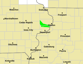
Northwestern Cedar County in east central Iowa...
Southwestern Dubuque County in northeastern Iowa...
Western Jones County in east central Iowa...
Southeastern Delaware County in northeastern Iowa...
Eastern Linn County in east central Iowa...
* Until 345 PM CDT.
* At 320 PM CDT, a severe thunderstorm capable of producing a tornado
was located over Martelle, or 8 miles southwest of Anamosa, moving
north at 70 mph.
HAZARD...Tornado.
SOURCE...Radar indicated rotation.
IMPACT...Flying debris will be dangerous to those caught without
shelter. Mobile homes will be damaged or destroyed.
Damage to roofs, windows, and vehicles will occur. Tree
damage is likely.
* This dangerous storm will be near...
Anamosa, Springville, Langworthy, Viola, Stone City, Wapsipinicon
State Park, and Matsell Bridge Natural Area around 325 PM CDT.
Monticello, Prairieburg, Monticello Municipal Airport, and Jones
County Fairgrounds around 330 PM CDT.
Hopkinton and Buck Creek around 335 PM CDT.
Turtle Creek Park around 340 PM CDT.
PRECAUTIONARY/PREPAREDNESS ACTIONS...
TAKE COVER NOW! Move to a basement or an interior room on the lowest
floor of a sturdy building. Avoid windows. If you are outdoors, in a
mobile home, or in a vehicle, move to the closest substantial shelter
and protect yourself from flying debris.
&&
LAT...LON 4191 9133 4193 9145 4245 9142 4238 9100
TIME...MOT...LOC 2020Z 194DEG 60KT 4200 9137
TORNADO...RADAR INDICATED
MAX HAIL SIZE...<.75 IN
$$
Gunkel
IAC031-055-061-105-113-162045-
/O.NEW.KDVN.TO.W.0011.240416T2020Z-240416T2045Z/
BULLETIN - EAS ACTIVATION REQUESTED
Tornado Warning
National Weather Service Quad Cities IA/IL
320 PM CDT Tue Apr 16 2024
The National Weather Service in the Quad Cities has issued a
* Tornado Warning for...
Northwestern Cedar County in east central Iowa...
Southwestern Dubuque County in northeastern Iowa...
Western Jones County in east central Iowa...
Southeastern Delaware County in northeastern Iowa...
Eastern Linn County in east central Iowa...
* Until 345 PM CDT.
* At 320 PM CDT, a severe thunderstorm capable of producing a tornado
was located over Martelle, or 8 miles southwest of Anamosa, moving
north at 70 mph.
HAZARD...Tornado.
SOURCE...Radar indicated rotation.
IMPACT...Flying debris will be dangerous to those caught without
shelter. Mobile homes will be damaged or destroyed.
Damage to roofs, windows, and vehicles will occur. Tree
damage is likely.
* This dangerous storm will be near...
Anamosa, Springville, Langworthy, Viola, Stone City, Wapsipinicon
State Park, and Matsell Bridge Natural Area around 325 PM CDT.
Monticello, Prairieburg, Monticello Municipal Airport, and Jones
County Fairgrounds around 330 PM CDT.
Hopkinton and Buck Creek around 335 PM CDT.
Turtle Creek Park around 340 PM CDT.
PRECAUTIONARY/PREPAREDNESS ACTIONS...
TAKE COVER NOW! Move to a basement or an interior room on the lowest
floor of a sturdy building. Avoid windows. If you are outdoors, in a
mobile home, or in a vehicle, move to the closest substantial shelter
and protect yourself from flying debris.
&&
LAT...LON 4191 9133 4193 9145 4245 9142 4238 9100
TIME...MOT...LOC 2020Z 194DEG 60KT 4200 9137
TORNADO...RADAR INDICATED
MAX HAIL SIZE...<.75 IN
$$
Gunkel


")